
Showing 13 items matching "'no' to lot sub-division"
-
 Marysville & District Historical Society
THE TRIANGLE NEWS-VOL 42 NO 13-APRIL 3 2015
... ...'no' to lot sub-division...marysville victoria australia alexandra secondary college debutante ball a success what's on when in april community announcement open garden a success gallipoli park precinct creative triangle church notices recreation vehicle discharge yea swimming pool advertisements lions triangle tool library 'no' to lot sub-division taggerty market eildon saturday marysville triangle good friday appeal mayor's chair by cr margaret rae women in business introduction event lily m news buxton progress assocn autumn pot luck dinner easter monday with marysville preschool marysville golf report new at country touch marysville & triangle commmunity foundation easter church services intrepid triangle bushwalkers alexandra district ambulance support highwood health open house day marysville cultural community agm marysville jazz & blues weekend free community seminars for bushfire affected communities council adopts new rating strategy easter office closures notice of special meeting of council marysville has a new vicar residential and rural real estate pet registrations easter saturday street stalls marysville triangle real estate THE TRIANGLE NEWS-VOL 42 NO 13-APRIL 3 2015 ...marysville, victoria, australia, alexandra secondary college debutante ball a success, what's on when in april, community announcement, open garden a success, gallipoli park precinct, creative triangle, church notices, recreation vehicle discharge, yea swimming pool, advertisements, lions triangle tool library, 'no' to lot sub-division, taggerty market eildon saturday, marysville triangle good friday appeal, mayor's chair by cr margaret rae, women in business introduction event, lily m news, buxton progress assocn autumn pot luck dinner, easter monday with marysville preschool, marysville golf report, new at country touch, marysville & triangle commmunity foundation, easter church services, intrepid triangle bushwalkers, alexandra district ambulance support, highwood health open house day, marysville cultural community agm, marysville jazz & blues weekend, free community seminars for bushfire affected communities, council adopts new rating strategy, easter office closures, notice of special meeting of council, marysville has a new vicar, residential and rural real estate, pet registrations, easter saturday street stalls, marysville triangle real estate -
 Greensborough Historical Society
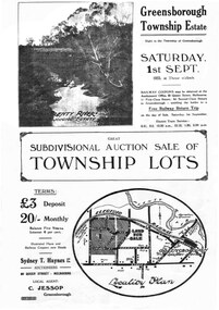
Flyer - Advertising Leaflet - Digital Image, Greensborough Township Estate, 01/09/1923
... Sub-division into 129 lots of land belonging to the Scotland Family, bounded by William Street, Eliza Street, James (Jessop) Street and south of Lorimer Street. ...Sub-division into 129 lots of land belonging to the Scotland Family, bounded by William Street, Eliza Street, James (Jessop) Street and south of Lorimer Street. ...Sub-division into 129 lots of land belonging to the Scotland Family, bounded by William Street, Eliza Street, James (Jessop) Street and south of Lorimer Street. Auction 1 September 1923Digital copy of plan. Has been digitally corrected from damaged original.subdivision plans, greensborough township estate, scotland family -
 Greensborough Historical Society
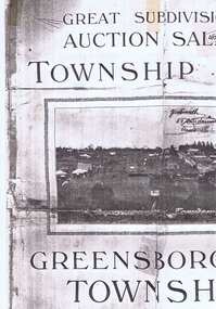
Plan, Greensborough Township Estate, 01/09/1923
... Sub-division into 129 lots of land belonging to the Scotland Family, bounded by William Street, Eliza Street, James (Jessop) Street and south of Lorimer Street. ...Sub-division into 129 lots of land belonging to the Scotland Family, bounded by William Street, Eliza Street, James (Jessop) Street and south of Lorimer Street. ...Sub-division into 129 lots of land belonging to the Scotland Family, bounded by William Street, Eliza Street, James (Jessop) Street and south of Lorimer Street. Auction 1 September 1923Photocopy, double-sidedsubdivision plans, greensborough township estate, scotland family -
 Ringwood and District Historical Society
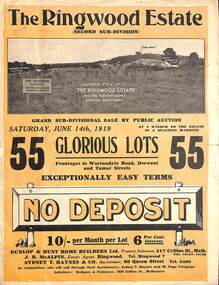
Pamphlet - Land Auction Brochure, The Ringwood Estate - Second Sub-Division, Ringwood, Victoria - 1919
... Lot 37 Tamar Street. Double sided bi-fold leaflet advertising subdivision site, layout of streets and allotments, summary of local features and services and terms of sale. The Ringwood Estate - Second Sub-Division ...Double sided bi-fold leaflet advertising subdivision site, layout of streets and allotments, summary of local features and services and terms of sale. Auction Saturday June 14th, 1919. 55 Lots. Subdivision includes Warrandyte Road, Tamar Street, Mersey Street and Derwent Street. Property Sales - Dunlop & Hunt Home Builders Ltd., 317 Collins Street, Melbourne, Tels 10104-10105. Agents - J.B. McAlpin, Tel. Ringwood 7. Auctioneers - Sydney T. Haynes & Co., 60 Queen Street, Melbourne, Tel. 3400. Solicitors - Hodgson & Finlayson, 360 Collins Street, Melbourne. Inset photographs of local views including existing 4-roomed bungalow on Lot 37 Tamar Street. -
 Greensborough Historical Society
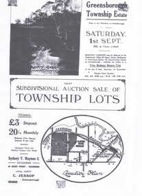
Flyer - Advertising Leaflet, J.C.Jessop, Greensborough Township Estate, 01/09/1923
... Sub-division into 129 lots of land belonging to the Scotland Family, bounded by William Street, Eliza Street, James (Jessop) Street and south of Lorimer Street. ...Sub-division into 129 lots of land belonging to the Scotland Family, bounded by William Street, Eliza Street, James (Jessop) Street and south of Lorimer Street. ...Sub-division into 129 lots of land belonging to the Scotland Family, bounded by William Street, Eliza Street, James (Jessop) Street and south of Lorimer Street. Auction 1 September 1923Copy of plan. Has been digitally corrected from damaged original.subdivision plans, greensborough township estate, scotland family, greensborough -
 Eltham District Historical Society Inc
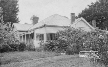
Photograph, Belle Vue, Livingstone Road, Eltham, c.1960, 1960c
... lot in Livingstone Road. The house and many old trees on the site have been subject to a heritage overlay under the Nillumbik Planning Scheme. Despite that overlay, most of the heritage trees were removed during sub-division and development of the property....lot in Livingstone Road. The house and many old trees on the site have been subject to a heritage overlay under the Nillumbik Planning Scheme. Despite that overlay, most of the heritage trees were removed during sub-division and development of the property. belle vue, eltham, eric staff, houses, livingstone road, staff family Digital file only from scan of copy on loan to EDHS Belle Vue, Livingstone Road, Eltham, c.1960 Photograph Photograph ...Photo taken at time of ownership by Eric Staff. Originally purchased by pioneer Eltham farmer Henry Stooke, Belle Vue farm comprised about 56 ha (140 acres) extending northerly from the northern boundary of Holloway’s 1851 Little Eltham subdivision. On the present day map the southern boundary was just north of Elsa Court and Grove Street. The western boundary was the Diamond Creek and extended northerly to Main Road where it turns easterly towards Research. It was traversed by the main road to Kangaroo Ground and beyond and from 1912 by the railway to Hurstbridge. From 1895 the farm was owned by William Williams and his wife Mary Ann. In 1914-1915 they built a new house now known as “Belle Vue”. They sold the land in 1920 and residential subdivision began soon after that. “Belle Vue” remains today on a large residential lot in Livingstone Road. The house and many old trees on the site have been subject to a heritage overlay under the Nillumbik Planning Scheme. Despite that overlay, most of the heritage trees were removed during sub-division and development of the property.Digital file only from scan of copy on loan to EDHSbelle vue, eltham, eric staff, houses, livingstone road, staff family -
 Eltham District Historical Society Inc
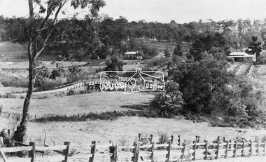
Photograph, View at Eltham, Vic, c.1924
... Bridge Street was created as part of the sub-division. Most of the sub-division was residential lots but the creek valley was divided into lots for small farms. ...Bridge Street was created as part of the sub-division. Most of the sub-division was residential lots but the creek valley was divided into lots for small farms. ...Copy of possible Rose Stereograph Co. postcard “View at Eltham, Vic.”, c.1924 looking southwest from Main Road near York Street to Bridge Street and the original 1875 bridge across what is now the Alistair Knox Park The land in the foreground was first bought from the Crown by J.M. Holloway in 1851. The land was sub-divided and called "Little Eltham". Bridge Street was created as part of the sub-division. Most of the sub-division was residential lots but the creek valley was divided into lots for small farms. Council started to buy the land for the Eltham Town park in the early 1960s. The area was used as a garbage tip and filled above the flood plain of the creek. Development of the land for a park began in the early 1970s. The house on the right was owned for many years by the Hill family until Council bought it in the early 1960s. The house was built in the 1850s or 60s. The house on the left stood on what is now the southwest corner of Susan and Bridge Streets. The Braithwaite family was associated with this house. The double line of fencing in the foreground was a continuation of York Street to the creek. The Bridge Street bridge was built in 1875 and replaced in 1958. (Ref: Early view of Little Eltham; Byways of History by Colleen Ison, Publication unk, 24 August 1982) Reproduced on p61 of 'Pioneers & Painters' Date estimated on same as View at Hurstbridge featuring Wattle Valley EstateThis photo forms part of a collection of photographs gathered by the Shire of Eltham for their centenary project book,"Pioneers and Painters: 100 years of the Shire of Eltham" by Alan Marshall (1971). The collection of over 500 images is held in partnership between Eltham District Historical Society and Yarra Plenty Regional Library (Eltham Library) and is now formally known as the 'The Shire of Eltham Pioneers Photograph Collection.' It is significant in being the first community sourced collection representing the places and people of the Shire's first one hundred years.Digital image 120 format B&W negative Prints 17 x 25 cm and 10 x 15 cmsepp, shire of eltham pioneers photograph collection, eltham, bridge street, bridge, alistair knox park, braithwaite, bridge street bridge, eltham town park, hill family home, main road, pioneers and painters, york street -
 Eltham District Historical Society Inc
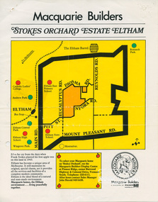
Document, Stokes Orchard Estate Eltham; Macquarie Builders, 1979c
... lots and streets were divided up into 5 acre blocks, which were not able to be subdivided till the 1990s when the sewer was run up Diosma Road. Stokes Place was part of the Stokes Orchard Estate which was developed from the break-up of the the orchard owned by Frank Stokes who lived on the northeast corner of Nyora Road and Eucalyptus Road. His daughter Beryl advised that the Shire had levied a rate assessment on individual parcels of land within the orchard which became unaffordable resulting in its sub-division...lots and streets were divided up into 5 acre blocks, which were not able to be subdivided till the 1990s when the sewer was run up Diosma Road. Stokes Place was part of the Stokes Orchard Estate which was developed from the break-up of the the orchard owned by Frank Stokes who lived on the northeast corner of Nyora Road and Eucalyptus Road. His daughter Beryl advised that the Shire had levied a rate assessment on individual parcels of land within the orchard which became unaffordable resulting in its sub-division ...Sales brochure including photocopy map of Stokes Place lots and Sales Manager's business card (John J. Herold). Stage 1 implemented c.1976 and Stage 2 c.1979. As shown on the plan, the lots along Diosma Road did not eventuate due to the lack of sewer system. These lots and streets were divided up into 5 acre blocks, which were not able to be subdivided till the 1990s when the sewer was run up Diosma Road. Stokes Place was part of the Stokes Orchard Estate which was developed from the break-up of the the orchard owned by Frank Stokes who lived on the northeast corner of Nyora Road and Eucalyptus Road. His daughter Beryl advised that the Shire had levied a rate assessment on individual parcels of land within the orchard which became unaffordable resulting in its sub-division and sell off. The Stokes Orchard Estate was developed by Macquarie Builders in two stages starting with stage 1 in 1976. Stokes Place was part of Stage 2 in 1979. The Estate was bounded between Nyora Road, Eucalyptus Road, Diosma Road and Stokes Place. The original orchard only just reached the left most portions of Stokes Place and did not go fully up to Diosma, rather to just beyond the extant of Stokes Place. Stokes Place was known within the family as "The Oats" as that is where they grew oats. Frank Stokes moved to Eltham c.1945 after visiting Harold Bird to view his orchard, located diagonally opposite Stokes Orchard from the intersection of Eucalyptus Road, Pitt Street and Nyora Road. It was on Harold Bird's recommendation that Frank purchased the land.The Stokes Orchard Estate collection is typical of housing developments of the late 1970s and 1980s. It was one of the earliest estates in Eltham following the nearby Woodridge Estate development.A4 colour brochure double sided, A4 photocopy and business cardAs notedstokes place, eltham, stokes orchard, stokes orchard estate, streets, houses, peter and carla vermey -
 Bendigo Historical Society Inc.
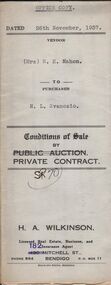
Document - H.A. & S.R. WILKINSON COLLECTION: CONTRACT OF SALE
... Svanosio (buyer) for land situate in Sternberg Street, Bendigo, being lot 3 on plan of sub-division No. 13862, having a frontage of 60 feet by a depth of 107 feet. ...Svanosio (buyer) for land situate in Sternberg Street, Bendigo, being lot 3 on plan of sub-division No. 13862, having a frontage of 60 feet by a depth of 107 feet. ...This business was owned by father and son, Henry Archibald Wilkinson and Samuel Ronald "Ron" Wilkinson. Henry (1882-1954) was born in Shepparton and died in Bendigo. He was married to Grace Hovendon in 1908. Samuel Ronald "Ron" (1914-1995), Henry's son, was married to Florence Jean McKerlie in 1937.Conditions of sale by private contract dated 26th November, 1937 between Mrs. R.E. Mahon (seller) and N.L. Svanosio (buyer) for land situate in Sternberg Street, Bendigo, being lot 3 on plan of sub-division No. 13862, having a frontage of 60 feet by a depth of 107 feet. Price 40 pounds. Attached a drawing of the sub-division.organization, business, h.a. & s.r wilkinson real estate -
 Warrnambool and District Historical Society Inc.
Map - Soldier Settlement Map, Soldier Settlement Commission, Tarrone Estate Alex Boyd, 1940s
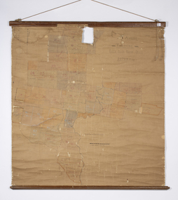
... divisions probably produced by the Soldier Settlement Commission. The map is incomplete with lots 48,49 and 50 missing. The Soldier Settlement Commission purchased 23,373 acres of Tarrone Station from the Boyd brothers in 1947 and the sub divided lots were occupied by soldier settlers commencing in 1949. ...divisions probably produced by the Soldier Settlement Commission. The map is incomplete with lots 48,49 and 50 missing. The Soldier Settlement Commission purchased 23,373 acres of Tarrone Station from the Boyd brothers in 1947 and the sub divided lots were occupied by soldier settlers commencing in 1949. ...This is a map of the Tarrone Soldier Settlement land divisions probably produced by the Soldier Settlement Commission. The map is incomplete with lots 48,49 and 50 missing. The Soldier Settlement Commission purchased 23,373 acres of Tarrone Station from the Boyd brothers in 1947 and the sub divided lots were occupied by soldier settlers commencing in 1949. Tarrone Station was established in 1840 by Doctors Kilgour and Bernard and the Boyd brothers secured the free hold in the 1890s and retained it until 1947. The map hung for many years in the Warrong school near Hawkesdale.This map is of considerable interest as an original item from the establishment of the Tarrone Soldier Settlement..The map is made of brown cloth and creased. The edges are tattered and there is a piece missing at the top. It is a map of allotments, hand drawn and with faded colours in red, blue and yellow. The names of localities and land holders are hand written in ink and chalk. The map is contained within two pieces of wood at the bottom and the top. There are two screws and a cord to hang on a wall. A scale of measurement is shown under the map. tarrone soldiers settlement, boyd brothers tarrone -
![Map, Millbank Estate Bacchus Marsh Thursday 4th October 1888 [Land sales], 1924](/media/collectors/5e461d8021ea67224c82f2a1/items/67765662eb6d2cbd24e0797f/item-media/67765682eb6d2cbd24e07a41/item-fit-380x285.jpg?cb=6) Bacchus Marsh & District Historical Society
Bacchus Marsh & District Historical SocietyMap, Millbank Estate Bacchus Marsh Thursday 4th October 1888 [Land sales], 1924
... sub-divided and offered for sale in 62? lots on the 4th October 1888. The lots had frontages to Ballarat Road (Main Street), Maddingley Road (now Grant Street), Turner Street, Millbank Street, Clarinda Road (now Clarinda Street), and an unnamed street south of Turner Street (possibly known as Grant Street at this time) which connected to Maddingley Road through the vicinity of the present day Bacchus Marsh Hospital. This was a significant sub-division...sub-divided and offered for sale in 62? lots on the 4th October 1888. The lots had frontages to Ballarat Road (Main Street), Maddingley Road (now Grant Street), Turner Street, Millbank Street, Clarinda Road (now Clarinda Street), and an unnamed street south of Turner Street (possibly known as Grant Street at this time) which connected to Maddingley Road through the vicinity of the present day Bacchus Marsh Hospital. This was a significant sub-division ...The Millbank Estate was a parcel of land close to the centre of the shopping area of Bacchus Marsh which was sub-divided and offered for sale in 62? lots on the 4th October 1888. The lots had frontages to Ballarat Road (Main Street), Maddingley Road (now Grant Street), Turner Street, Millbank Street, Clarinda Road (now Clarinda Street), and an unnamed street south of Turner Street (possibly known as Grant Street at this time) which connected to Maddingley Road through the vicinity of the present day Bacchus Marsh Hospital. This was a significant sub-division of land and represented a major expansion of residential housing in Bacchus Marsh in the late 19th century. The map includes a wealth of detail about the time of the sale, where it will take place, who the selling agents were, the deposit terms for purchases and details of a special train from Melbourne to Bacchus Marsh on sale day. The location of the allotments in relation to the shopping and commercial area of Bacchus Marsh, Maddingley and the railway station are indicated on an inset map within the overall map and poster. The Millbank Estate area was an area which had once belonged to the Grant family who were prominent early citizens of Bacchus Marsh and lived in a house in this area known as 'Millbank'.This land sale map is a typical example of housing estate land sales advertising maps produced by real estate agents in this era. The map is significant for the detailed information it provides about when and where land was sold for new housing estates in Bacchus Marsh in the late nineteenth century.Single page map showing land allotments for sale at auction in Bacchus Marsh in October 1888. A significant portion of the map is missing from the bottom right side. land sales bacchus marsh, land subdivsion bacchus marsh, housing estates land sales bacchus marsh, grant family bacchus marsh, millbank estate land sales -
 Bacchus Marsh & District Historical Society
Map - Land Sales Plan, Grantbank Estate Bacchus Marsh, 1924
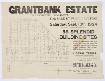
... sub-divided and offered for sale in 58 lots on the 13th September, 1924. It comprised an area of 15 acres, being a portion of the Millbank Estate which had been in the hands of the Grant family for 75 years. The lots had frontages to Gisborne Road, Patterson, William and Sutherland Streets. This was a significant sub-division...sub-divided and offered for sale in 58 lots on the 13th September, 1924. It comprised an area of 15 acres, being a portion of the Millbank Estate which had been in the hands of the Grant family for 75 years. The lots had frontages to Gisborne Road, Patterson, William and Sutherland Streets. This was a significant sub-division ...The Grantbank Estate was a parcel of land close to the centre of the shopping area of Bacchus Marsh which was sub-divided and offered for sale in 58 lots on the 13th September, 1924. It comprised an area of 15 acres, being a portion of the Millbank Estate which had been in the hands of the Grant family for 75 years. The lots had frontages to Gisborne Road, Patterson, William and Sutherland Streets. This was a significant sub-division of land and represented a major expansion of residential housing in Bacchus Marsh in the early 20th century.This land sale map is a typical example of housing estate land sales advertising maps produced by real estate agents in this era. The map is significant for the detailed information it provides about when and where land was sold for new housing estates in Bacchus Marsh in the early twentieth century.Printed paper mapland sales bacchus marsh, land subdivsion bacchus marsh, housing estates land sales bacchus marsh, grant family bacchus marsh -
 Melbourne Tram Museum
Ephemera - Real estate sale, Duncan & Weller Auctioneers, "Burwood Park Estate" Boundary Road, 1926
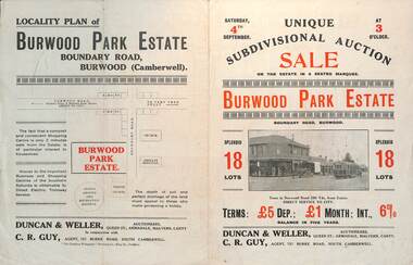
... The plan of sub-division shows 18 lots for sale....The plan of sub-division shows 18 lots for sale. Demonstrates the style of land sale pamphlet including the availability of tram services to prospective purchasers. ...Pamphlet advertising the sale of land at the Burwood Park Estate, Boundary Road Burwood, Saturday 4th September. Does not give the year, most likely 1926. Promotes the tram service, nearby shops, the suitability of the soil for gardening and other facilities. Has a photo of possibly W 259 at the terminus. The plan of sub-division shows 18 lots for sale.Demonstrates the style of land sale pamphlet including the availability of tram services to prospective purchasers.Pamphlet - folded - printed in two colours of cream coloured paper with photographs and plans.sale of land, trams, real estate, burwood park, burwood
