Showing 73 items matching "'points of view'"
-
 City of Warrnambool Rowing Club
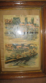
Picture (copy), "Points of View"
... "Points of View"......'points of view'...Armour titled 'Points of View' and subtitled 'The River as it Appears to the Winners of an Easy Race' showing starboard view of a straight four rowing erect and without obvious distress. ...Armour titled 'Points of View' and subtitled 'The River as it Appears to the Winners of an Easy Race' showing starboard view of a straight four rowing erect and without obvious distress. ...Points of view G.D. Armour...Armour titled 'Points of View' and subtitled 'The River as it Appears to the Winners of an Easy Race' showing starboard view of a straight four rowing erect and without obvious distress. ...Half page illustration from Punch p. 37. Two panel illustration by G.D. Armour titled 'Points of View' and subtitled 'The River as it Appears to the Winners of an Easy Race' showing starboard view of a straight four rowing erect and without obvious distress. Below 'As it Appears to the Losers of a Hard Race' showing closeup starboard stern quarter view of a straight four collapsed over their oars, with the surrounding scenery drawn in a wavy haze. Part of the Tom Weil Collection. Thomas E Weil is a very knowledgeable and respected collector of rowing memorabilia from all over the world. His extensive collection includes material from many years of the Oxford and Cambridge University Boat Race, and Henley Royal Regatta. He also lectures and writes on rowing history and is a Trustee of the River and Rowing Museum. River & Rowing Museum, Mill Meadows, Henley on Thames, Oxfordshire, RG9 1BF Telephone: 01491 415600 General enquiries: [email protected] of an Ink and watercolor painting of two rowing crews. Two panel copy of an illustration by G.D. Armour titled 'Points of View' and subtitled 'The River as it Appears to the Winners of an Easy Race' showing starboard view of a straight four rowing erect and without obvious distress. Below 'As it Appears to the Losers of a Hard Race' showing closeup starboard stern quarter view of a straight four collapsed over their oars, with the surrounding scenery drawn in a wavy haze.Points of view G.D. Armourcity of warrnambool rowing club, warrnambool rowing club, hopkins river warrnambool, hopkins river warrnambool, g.d. armou, 'points of view' -
 Yarra City Council
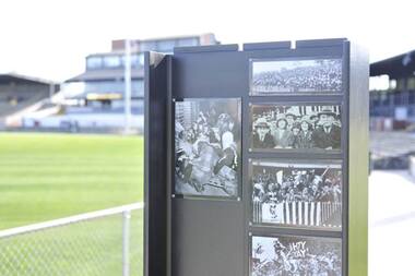
Artwork, other - Integrated archives, Futago, Points of View, 2011
... Points of View...Each panel incorporates a pin board on one side with archival photographs, cartoons and humorous or nostalgic ephemera. Points of View Artwork, other Integrated archives Futago ...Five interpretive panels have been installed around the perimeter of the oval at Victoria Park. Each panel incorporates a pin board on one side with archival photographs, cartoons and humorous or nostalgic ephemera.local history, community, collingwood -
 Bendigo Art Gallery
Painting, Peter ATKINS, Points of view (an anthology of short stories), 2007
... Points of view (an anthology of short stories)...Bendigo Art Gallery 42 View Street Bendigo goldfields australian artist colour circles abstract c.l; PATCHES TARPS, c.r; SHEBP(illeg.) TRANSPORT Points of view (an anthology of short stories) Painting Peter ATKINS ...c.l; PATCHES TARPS, c.r; SHEBP(illeg.) TRANSPORTaustralian artist, colour, circles, abstract -
 Surrey Hills Historical Society Collection
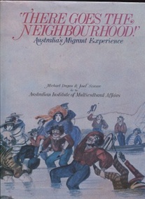
Book, Michael Dugan et al, There goes the Neighbourhood, 1984
... It also looks at the new arrivals - those accepted and those rejected - from the points of view of people already established in the country....It also looks at the new arrivals - those accepted and those rejected - from the points of view of people already established in the country. ...The book presents a rich picture of a nation in the making. It is a portrait of Australia's development during the 19th and 20th centuries seen through the eyes of people arriving to make their homes here. It also looks at the new arrivals - those accepted and those rejected - from the points of view of people already established in the country.The book has a place in this collection by virtue of Michael Dugan having been a local resident.34 cm H; 200 p; includes chronology, List of sources and texts for each chapterTitle page: signed by one of the authors: Michael Dugansocial interaction--australia--history, australia - social life and customs, australia - social conditions, australia - emigration and immigration - history, minorities - australia - history, (mr) michael dugan, (mr) josef szware -
 Bendigo Historical Society Inc.
Document - SUMMARY OF A TALK BY COUNCILLOR DAVID JONES
... Summary mentions War history briefly, changing peoples points of view and climate change. There is also a contribution by Carol Holsworth of an article that was in the Bendigo Advertiser about a man who was asked to produce proof of his age....Summary mentions War history briefly, changing peoples points of view and climate change. There is also a contribution by Carol Holsworth of an article that was in the Bendigo Advertiser about a man who was asked to produce proof of his age. ...Five copies of a Summary of talk by Councillor David Jones, Mayor City of Greater Bendigo to Society AGM August 2006. Titled A society which does not understand history is sure to repeat its mistakes. Summary mentions War history briefly, changing peoples points of view and climate change. There is also a contribution by Carol Holsworth of an article that was in the Bendigo Advertiser about a man who was asked to produce proof of his age.history, summary of talk by councillor david jones, city of greater bendigo, graeme pearlman, csiro, carol holsworth, bendigo advertiser, mr berriman pm -
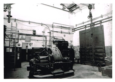 Melbourne Tram Museum
Photograph - Set of 5 Black & White Photograph/s, Department of Infrastructure (DOI), 1999
... Set of 5 black and white photographs of the Glenhuntly depot sub-station, taken by the photographic section of the Dept of Infrastructure during early 1999. .1 - interior view of sub-station showing a rotary converter, crane rail and substation equipment. .2 - ditto .3 - High Voltage cable entry points .4 - view of Glenhuntly Depot showing location of sub-station through the large doors. .5 - Transformer with Mike Ryan standing alongside...Set of 5 black and white photographs of the Glenhuntly depot sub-station, taken by the photographic section of the Dept of Infrastructure during early 1999. .1 - interior view of sub-station showing a rotary converter, crane rail and substation equipment. .2 - ditto .3 - High Voltage cable entry points .4 - view of Glenhuntly Depot showing location of sub-station through the large doors. .5 - Transformer with Mike Ryan standing alongside Photograph Set of 5 Black & White Photograph/s Department of Infrastructure (DOI) ...Set of 5 black and white photographs of the Glenhuntly depot sub-station, taken by the photographic section of the Dept of Infrastructure during early 1999. .1 - interior view of sub-station showing a rotary converter, crane rail and substation equipment. .2 - ditto .3 - High Voltage cable entry points .4 - view of Glenhuntly Depot showing location of sub-station through the large doors. .5 - Transformer with Mike Ryan standing alongsideEach photo has on the rear a "Copyright Department of Infrastructure with details for reordering and a hand written numbers - 1999 - 101 to 110 (not all photos printed).trams, tramways, substation, rotary converters, glenhuntly tram depot -
 Pyrenees Shire Council
photograph, Avoca in 1866 by J.N. Dallimore, 1866
... The Avoca Mail of 7 November 1866 reported: Mr Dallimore of Woodstock, determined that the town of Avoca and its environs shall be pictorially represented at the Victorian and Paris Exhibitions, has we learn, forwarded a series of photographs representing the High Street and the Pyrenees [Victoria] from different points of view. All the photographs are well executed and will possess considerable interest for the friends of Avocaites visiting the World’s Fair in 1867. ...The Avoca Mail of 7 November 1866 reported: Mr Dallimore of Woodstock, determined that the town of Avoca and its environs shall be pictorially represented at the Victorian and Paris Exhibitions, has we learn, forwarded a series of photographs representing the High Street and the Pyrenees [Victoria] from different points of view. All the photographs are well executed and will possess considerable interest for the friends of Avocaites visiting the World’s Fair in 1867. ...J.N. Dalimore was an amateur photographer and settler who arrived at Port Phillip (Victoria) with his wife in September 1840 on board the Himalaya. Dalimore lived at Woodstock Station, near Avoca, he exhibited view photographs of the district at the 1866 Melbourne Intercolonial Exhibition that were sent on to the 1867 Paris Universal Exhibition. The Avoca Mail of 7 November 1866 reported: Mr Dallimore of Woodstock, determined that the town of Avoca and its environs shall be pictorially represented at the Victorian and Paris Exhibitions, has we learn, forwarded a series of photographs representing the High Street and the Pyrenees [Victoria] from different points of view. All the photographs are well executed and will possess considerable interest for the friends of Avocaites visiting the World’s Fair in 1867. Also included were views of Dallimore’s own station. They won him a medal 'for good Landscape Photography’. His panoramic photograph of Avoca is in the Shire Council significant as a historic photograph of Avoca, locally significant to the Central Highlands Region of Victoria as a representation of local landscape and/or culture Black and white photograph of Avoca showing Rutherford Street to the left and the original site of the Avoca Hotel"verso (affixed): AVOCA MAIL, 1st JUNE 1867. ""A remarkably well-executed photograph of the town of Avoca taken in 1866. and forming one of the exhibits at the Melbourne Exhibition, has been presented to the Avoca Shire Councilby F.W. Dalimore formally of Woodstock verso (affixed): No. 875 Intercolonial Exhibition 1866 Exhibitor: Avoca Shire Council Class: Section:" -
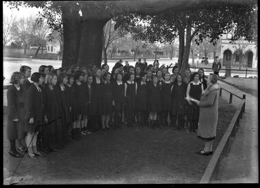 City of Melbourne Libraries
Photograph (item), Bull, Hugh Jones, 1897-1993, Miss Ida Park conducts the North Fitzroy State School Choir
... In his speech Monsieur Puaux stated that “from the cultural, linguistic and artistic points of view it was excellent that the Australian public should have an opportunity to see foreign film in the original language.” ...In his speech Monsieur Puaux stated that “from the cultural, linguistic and artistic points of view it was excellent that the Australian public should have an opportunity to see foreign film in the original language.” ...The pupils of Falconer Street Central School No.3918 in North Fitzroy rehearse with conductress Miss Ida Park for their performance at the Temperance Hall, Russell Street Melbourne with proceeds going to the Lord Mayor’s Fund. The house on the right of the photograph is Jubilee House, 126 Michael Street North Fitzroy and is extant. Photographer notations on slide: Choir At Fitzroy State School 1933 B5 While this photograph appears not to have been published, a photograph taken from a different angle of the same event was published in The Age 21 July 1933. SCHOOL CHILDREN SING IN THE OPEN AIR. “A choir of children at North Fitzroy practise their songs for a Pantomime, to be given in the Temperance Hall for the Lord Mayor's Fund on Wednesday next. On the extreme left is the conductress of the Choir (Miss Ida Park).” Reference: http://nla.gov.au/nla.news-article204368572 Research by project volunteer, Fiona Collyer: Children of The Falconer Street Central School Choral Society, trained by conductress Miss Ida Park, along with dance and gymnastics pupils of Misses Dorothy Gibb and Inez Ellis, performed in the “Cinderella” pantomime at the Temperance Hall in Russell Street, Melbourne on 26 July, 1933. The proceeds went to the Lord Mayor’s Fund. Conductress Miss Ida Park (1904- 1952) lived in the North Fitzroy and Clifton Hill area all her life. She was immersed in the music world of Melbourne and was a member of the Musical Society of Victoria. Ida graduated from Melbourne University Conservatorium with a Bachelor of Music degree in 1929 before departing for London where she studied piano and organ at the Royal Academy of Music. Ida returned to Melbourne in 1931, and billed as “The Gifted Young Australian Pianist”, held pianoforte recitals of classical music at Assembly Hall, Collins Street. She also played the organ for services at St Paul’s Independent Church in Delbridge Street, North Fitzroy and later St Luke’s, North Fitzroy. Ida conducted the children of the Falconer Street Central School Choral Society as they competed in the State School Choral Championships and the 85 children of the Fitzroy City Centenary Choir who sang at Melbourne’s Centenary celebrations of 1934/35. In 1945, Ida married Charles Hazeldine, a tenor and returned digger who had served in two world wars. The pair performed together in many concerts over the years. Tragically, both Ida and Charles were badly injured when struck by a car while crossing Queens Parade Clifton Hill in June 1952, with Ida dying from head injuries at St Vincent’s Hospital soon after. She was 48 years old. Charles wrote on Ida’s death notice - “Called home.” The choir were pupils of Falconer Street Central School No. 3918 in North Fitzroy which was built in 1915 to provide upper primary education for grades 5 to 8 for the area. In 1957 it became Fitzroy High School. In 1992, the Kennett Government swept to power, embarking on a program of fiscal austerity and privatisation of government services. 390 government schools were closed, with the land proposed to be sold to developers. 7000 teachers were sacked: 10% of Victoria’s public school teachers. Auxiliary school staff also lost their jobs. Amongst the first to close was Fitzroy High School. Fearful that the land would be sold, hundreds of students, parents, teachers and local residents occupied the building around-the-clock in four hour shifts and overnight for 14 months, sleeping on gym mats in the principal’s office and administrators’ wing. The blockade was lifted when a arrangement was reached to allow Kangan Batman TAFE to use the school from 1993 until 1998. With the election of the Bracks Government in 1999, and construction of new buildings, Fitzroy High School was reopened in 2004 after a 12 year battle. Temperance Hall, at 172 Russell Street, where the children performed “Cinderella”, was built in 1872 by the Melbourne Total Abstinence Society as a venue for lectures, meetings and alcohol-free community concerts and events. From 1934, Temperance Hall was fitted out as a cinema and renamed the Imperial Theatre, showing popular Hollywood films, before closing in 1939 for renovations and reopening as the Savoy Theatre, Melbourne’s first “Continental” talkies cinema. At this time, Australian cinema programming was dominated by American and British films. The lessees, Continental Film Art Theatre began negotiating for theatre properties in Melbourne, Sydney, Adelaide, Brisbane, Perth and Auckland to screen foreign language films, hoping to present the finest productions from France, Germany, Holland and Italy. At the cost of £6000, the theatre was fitted with the latest Mirrophonic sound and projection system and enlarged to seat 800 patrons with luxurious, ultra modern fittings and furnishings in a colour palette of rust and beige. Instead of usherettes, General Manager Peter Dawson, hoping to bring a sophisticated European atmosphere to the theatre, employed attractive, multilingual “Continental hostesses” to assist guests (not patrons) and answer queries relating to the films. Collectively the hostesses spoke English, French, Dutch, German, Russian and Italian. The Age 20 May 1939- “Atmosphere is a very important part of the theatre's scheme. Ushers in the ordinary sense will not be employed; hostesses will look upon patrons as guests. They will be dressed in full evening dress, and the only indication that they are not guests is the little medallion pinned to their evening dress, on which their names are inscribed.” The hostesses were dressed in evening gowns of olive-green velvet, the full skirts embroidered with gold loops, wine velvet bolero jackets and long white kid gloves with silvery tiaras in their hair. For guests worried that they may not understand the plot, the management assured patrons that- “By means of superimposed English translations on the bottom of the screen, the dialogue is perfectly understandable and the whole witty story can be followed with ease.” The Gala opening of the Savoy Theatre, on 31 May 1939 was attended by a “who’s who” of Melbourne Society, the women wearing beautiful gowns, headdresses and furs. Amongst the guests were former premier Sir Stanley Argyle and Lady Argyle, former Lord Mayor Sir Harold Gengoult-Smith and his wife Cynthia, Field Marshall Thomas Blamey and Lady Blamey and Miss Jessie Brookes. The Vice Consul for France, Monsieur Frank Puaux and his wife attended, Madame Puaux dressed in a black satin gown and a musquash fur cape. She was presented with a beautiful bouquet of scarlet carnations and lily of the valley tied with the tricolour of France. In his speech Monsieur Puaux stated that “from the cultural, linguistic and artistic points of view it was excellent that the Australian public should have an opportunity to see foreign film in the original language.” “Letty” writing in Table Talk magazine described the atmosphere of “Continental” gaiety that had permeated Melbourne - “The Letters of Letty”, Table Talk 8 June 1939 “The “foreign influence” is definitely obtruding itself into the even tenor of Melbourne life these days…. but in the pleasantest manner possible! Included in the great number of Continental people who have recently made their homes here, we have stars of the Russian ballet settling in our midst…. and now… we have been presented with our own Continental picture theatre in the attractive shape of The Savoy, which opened its doors on Wednesday night for the exclusive release of foreign films. One could hardly recognise the old Temperance Hall in its adaptation to the smart, comfortable and thoroughly-intriguing Savoy Theatre. Where once this rather draughty old building stood in Russell Street there now greets us an unmistakable “Continental” edifice, living up to its exterior by sustaining within its walls its overseas’ atmosphere. Indeed, one feels as though one has crossed the threshold into a European city, stepping out of the unmistakably Australian street that is Russell into The Savoy lounge to be greeted by polite “messieurs” from the attractive, Continental-looking usherettes and to gaze upon a film as delightfully French in story and presentation as “La Kermesse Heroique.” But successful though “La Kermesse Heroique” proved on its initial presentation inside the theatre, the debut was no more triumphal than that made by the winning and pretty little French lass who had charge of the booking office outside in the foyer. With her attractive accent and Continental flair for making one “feel at home” she was undoubtedly one of the hits of the night-especially with the susceptible males, who spent very much longer in the lounge than is customary, racking their brains for excuses for making conversation with the attractive Parisienne! Those French girls certainly have a way with them!” The opening film, the 1935 French comedy “La Kermesse Heroique”, (The Heroic Sex) starring Francoise Rosay and Jean Murat (film now called “Carnival in Flanders”) was the winner of the Grand Prix du Cinema Francais as the finest picture of 1936 and described in the advertisement as “The Gay French Comedy of Laughter and Romance” The film is set during the 17th century Spanish occupation of Flanders in the Flemish town of Boom at the time of their annual festival. Hearing news of a pending visit to Boom by the commander, the Duke of Olivares and his army, and fearing rape and pillage, the boorish burgomaster feigns his own death, hoping the Spaniards will bypass the grieving town out of respect. The army arrives and the cowardly men of the town flee. The womenfolk decide on a different approach. Lead by the burgomaster’s beautiful wife Cornelia, they set out to to preserve the peace with grace and hospitality only to find the Spaniards attractive and virile, unlike their own husbands. The Sun newspaper described the film as “Mellow as a Stilton cheese, and as ripely suited to adult taste.” Preceding “La Kermesse Heroique” was a Gaumont British newsreel of King George VI and Queen Elizabeth departing for a tour of Canada and the Soviet documentary “Nine Months on a Drifting Ice Floe” During the war “Continental” films became difficult to source, so the Savoy screened Hollywood movies and held fund raisers for the war effort. After World War Two, the Savoy continued to screen “Continental” films, catering to post-war immigrants from Europe and bohemian Melburnians. In 1953, the Savoy had a wildly popular season with queues winding around the block to see Swedish summer romance “One Summer of Happiness” (Hon dansade en sommar) with its nude swimming scenes. The Chief Commonwealth Censor declined to cut the film on the grounds that although it displayed nudity, it was genuinely artistic. According to Wikipedia, film director Fred Schepisi was first exposed to European films such as “Bicycle Thieves”, “Rocco and His Brothers” and “The Wages of Fear” at the Savoy as a teenager, leading to his long career in filmmaking. In 1955, in response to the massive rise in car ownership, the Melbourne City Council recommended that parking stations be built on every block. The Savoy Theatre and adjacent buildings, which included the Golden Fleece Hotel were demolished in 1963 and replaced with Total House, a Brutalist commercial building consisting of a seven storey car park crowned by a four storey office block, shops at street level, and a basement theatre which housed the Lido Theatre Restaurant-Cabaret from 1965. The building was designed by architectural firm Bogle & Banfield Associates and named for the original tenant of the offices, French oil company, Total Oil Products P/L. The Lido Theatre Restaurant was managed by former Tivoli dancer and promoter David Hamilton McIlwraith, presenting dinner and a glamorous cabaret floor show of showgirls, (some topless) to accompany variety acts by local and international actors, singers, comedians and magicians. The interior of the Lido was opulently decorated in deep, lush green with old world gold trim and chandeliers. Handily, patrons could enter and leave via an elevator, straight from the building’s own car park! A four course gourmet dinner with show and dancing cost $8.00 in 1968. The Lido advertised in 1966 that “Every visitor to Melbourne soon discovers the brightest entertainment spot in the Southern Hemisphere with its million dollar decor, dining delights and spectacular stage productions.” Australian Jewish News - 21 April 1967 - “Superb decor and atmosphere, cuisine and service have been readily recognised as the contributing factors to the excellence of stage presentations, staging, costumes, decor and, of course, the actual choice of artists.” The bedazzling ensemble of 40 high-kicking, feathered and sequinned showgirls were advertised as the “Fabulous Lido girls and the controversial Baretop Lido Goddesses” who were described as “Statuesque Beauty as Nature intended” and “…a host of glamorous gals whose favourite shade is flesh pink.” Some of the acts who performed at the Lido were- -Broken Hill’s own - opera singer June Bronhill -1967. -Versatile singer Lovelace Watkins known as “Black Sinatra - 1967. -“Queen of the five-fingered boogie", honky-tonk and rollicking rag-time pianist, Winifred Atwell - 1967. -New Zealand pop duo, Bill and Boyd -1968. -American actress and soprano Kathryn Grayson -1968. -Denise Drysdale in “Say It With Music” -1968. -“Catwoman” Eartha Kitt -1969. -Internationally recognised female impersonator, Sydneysider Tracey Lee, (Maxwell Richie) billed as "controversial impressionist and singing personality from the famous Carousel Nightspot in Paris". -Frances Faye, American comedienne and show-tune singer and pianist-1969. -“Cry Guy” histrionic singer Johnnie Ray -1970. -Risqué revue “Oh Calcutta!” with some segments and the “four letter” words removed-1970. In 1970, under new management, the Lido was renovated with claret and gold wallpaper, midnight blue ceiling and a computerised fountain with fairy lights and relaunched by “The Tigress from Tiger Bay”, Shirley Bassey. The relaunch was short lived however, as later that year the venue became El Toro Espana, a Spanish restaurant and nightclub offering a four course meal for $4.50 while you watched the floorshow. The venue then briefly became the Red Garter Music Hall Theatre from 1972, then in 1974 the site became the 600 seat Total Theatre comprising of a cinema with a stage for live acts. There were also three bars to choose from - the Crush Bar, the Bleachers and the Snake Pit. Total Theatre had the unusual concept of a live music act, or plays, musicals and magicians followed by a film. In 1975 soprano Suzanne Steele featured, followed by the film “The Voyage” starring Sophia Loren and Richard Burton. In 1975, the Total held a rock film festival showing a Jimi Hendrix documentary, “Monterey Pop Festival”, “Pink Floyd in Pompeii” and more. In 1976, 17 year old Chrissy Amphlett, later of rock band Divinyls, played the role of Linda Lips for nine months in the Australian stage production of R-rated “sexual musical”, “Let My People Come” at the Total Theatre. The Total Theatre closed in 1979 and from 1980 to 2014 the venue became Billboard Nightclub, hosting local and international acts, including INXS, Tina Turner and John Farnham, and in 2009, 18 year old Taylor Swift. The venue is now called 170 Russell and presents hundreds of live local and international acts every year. In 2014, after being under threat of demolition, Total House was listed on the Victorian Heritage Register as “a landmark of post-World War II modernist design and…one of the earliest and best expressions of Brutalist architecture in Victoria”. References: RICHARD CROOKS ARRIVES SCHOOL AGAIN VENUE OF ROYAL VISIT (1939, May 31). The Age (Melbourne, Vic. : 1854 - 1954), p. 17. Retrieved November 21, 2025, from http://nla.gov.au/nla.news-article205629696 AMUSEMENTS. (1933, July 27). The Age (Melbourne, Vic. : 1854 - 1954), p. 12. Retrieved September 19, 2025, from http://nla.gov.au/nla.news-article204378853 https://larzra.wordpress.com/origins/ CONTINENTAL HOSTESSES, (1939, May 31). The Sun News-Pictorial (Melbourne, Vic. : 1922 - 1954; 1956), p. 27. Retrieved November 21, 2025, from http://nla.gov.au/nla.news-article278189387 The Letters of Letty (1939, June 8). Table Talk (Melbourne, Vic. : 1885 - 1939), p. 12. Retrieved October 29, 2025, from http://nla.gov.au/nla.news-article149320966 SAVOY THEATRE (1939, June 1). The Age (Melbourne, Vic. : 1854 - 1954), p. 7. Retrieved September 19, 2025, from http://nla.gov.au/nla.news-article205639035 NEW THEATRE OPENED (1939, June 1). The Argus (Melbourne, Vic. : 1848 - 1957), p. 8. Retrieved September 21, 2025, from http://nla.gov.au/nla.news-article12134234 https://en.wikipedia.org/wiki/Total_House Page [?] TOUCH OF SPAIN (1970, December 18). The Australian Jewish News (Melbourne, Vic. : 1935 - 1999), p. 35. Retrieved September 23, 2025, from http://nla.gov.au/nla.news-article262493757 No title (1935, June 11). The Herald (Melbourne, Vic. : 1861 - 1954), p. 27. Retrieved September 29, 2025, from http://nla.gov.au/nla.news-article244840169 Dine, wine, and watch a stage show (1966, November 16). The Australian Women's Weekly (1933 - 1982), p. 6. Retrieved November 9, 2025, from http://nla.gov.au/nla.news-article44025050 http://jonathanbollen.net/2011/02/26/tracey-lee/ LIDO ‘ART’ (1967, April 21). The Australian Jewish News (Melbourne, Vic. : 1935 - 1999), p. 8. Retrieved November 9, 2025, from http://nla.gov.au/nla.news-article263003136 THE FABULOUS LIDO (1965, October 22). The Australian Jewish News (Melbourne, Vic. : 1935 - 1999), p. 17. Retrieved November 9, 2025, from http://nla.gov.au/nla.news-article262983995 No title (1939, May 31). The Argus (Melbourne, Vic. : 1848 - 1957), p. 6. Retrieved November 21, 2025, from http://nla.gov.au/nla.news-article12134144 #NEW THEATRE OPENED (1939, June 1). The Argus (Melbourne, Vic. : 1848 - 1957), p. 8. Retrieved September 29, 2025, from http://nla.gov.au/nla.news-article12134234 https://en.wikipedia.org/wiki/Tracey_Lee_(female_impersonator) https://citycollection.melbourne.vic.gov.au/35b-40h-image-of-a-model-for-the-total-house-offices-and-car-park-on-russell-street/ https://www.theage.com.au/national/victoria/from-the-archives-1990-s-hundreds-of-school-closures-hit-victoria-20190801-p52cwj.html http://jonathanbollen.net/2011/05/29/the-lido-melbourne/Photographer notations on slide: primary schools, schools, music, education, choirs, fitzroy, cars, theatre restaurants, venues, films -
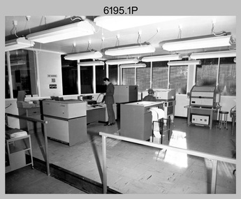
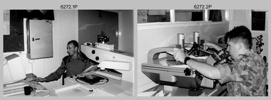
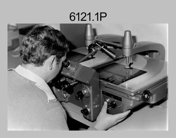
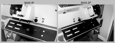 Bendigo Military Museum
Photograph - Aerotriangulation Production – Army Survey Regiment, Fortuna, Bendigo, c1989
... points on aerial photographs. Wild PUG4 point transfer devices as shown in photo .17P, were introduced in c1968 superseding the PUG2 devices. PUG4 devices were used by technicians to stereoscopically view the photography containing the survey control points and the mapping aerial photography. ...points on aerial photographs. Wild PUG4 point transfer devices as shown in photo .17P, were introduced in c1968 superseding the PUG2 devices. PUG4 devices were used by technicians to stereoscopically view the photography containing the survey control points and the mapping aerial photography. ...This collection of 17 photographs of Air Survey Squadron aerotriangulation equipment and personnel was taken at the Army Survey Regiment, Fortuna, Bendigo, circa 1989. The PDP 11/70 minicomputer was the operating system introduced in 1977 as the mainframe system for the control of the APC4, aerial triangulation block adjustments, SORA OP Analytical Orthophoto control, APR Analytical Terrain Profile Recorder computation, graphics, and general computing. The OMI/Nistri AP/C-3 analytical plotter shown in photo .1P to .6P and .9P was introduced in 1972–1973. The Zeiss (Jena) Stecometer analytic stereocomparator for air photography shown in photo .16P was introduced at Air Survey Squadron in 1963. Aerotriangulation production was expedited using computers for analytical photogrammetric processes. The technician accurately measured between pass, tie, and survey control points on aerial photographs. Wild PUG4 point transfer devices as shown in photo .17P, were introduced in c1968 superseding the PUG2 devices. PUG4 devices were used by technicians to stereoscopically view the photography containing the survey control points and the mapping aerial photography. The Control points were transferred from the control photography to the mapping diapositives of aerial photography by drilling their locations into the photographic emulsion. See item 6195.19P for more photos of aerotriangulation equipment and their operation in map production.This is a set of 17 photographs of Air Survey Squadron aerotriangulation equipment and personnel taken at the Army Survey Regiment at Fortuna, Bendigo, circa 1989. The photographs are on 35mm negative film and scanned at 96 dpi. They are part of the Army Survey Regiment’s Collection. .1) to .7) - Photo, black & white, c1989, OMI/Nistri APC/3-1 analytical stereoplotter. .8) - Photo, black & white, c1989, miscellaneous aerotriangulation equipment. .9) to.10) - Photo, black & white, c1989, Digital Equipment Corporation (DEC) 11 VO3-L Superminicomputer, with VT52 DECScope terminal. .11) to .15) - Photo, black & white, c1989, miscellaneous aerotriangulation equipment. .16) - Photo, colour, c1989, Zeiss (Jena) Stecometer, unidentified technician. .17) - Photo, black & white, c1989, Wild PUG4 point transfer device, unidentified technician..1P to .17P – There are no annotationsroyal australian survey corps, rasvy, fortuna, army survey regiment, air survey, aerotrig -
 Bendigo Military Museum
Photograph - Aerotriangulation Production – Army Survey Regiment, Fortuna, Bendigo, c1979
... points on aerial photographs. The OMI/Nistri AP/C-3 analytical plotter shown in photos .10P and .11P was introduced in 1972–1973. Photo .11P shows a coordinatorgraph attached to the AP/C-3. The Zeiss D2 Planimat Stereoplotter shown in photo .12P was used for analytical orthophoto control. Wild PUG4 point transfer devices shown in photos .17P to .19P were introduced in c1968 superseding the PUG2 devices. PUG4 devices were used by technicians to stereoscopically view...points on aerial photographs. The OMI/Nistri AP/C-3 analytical plotter shown in photos .10P and .11P was introduced in 1972–1973. Photo .11P shows a coordinatorgraph attached to the AP/C-3. The Zeiss D2 Planimat Stereoplotter shown in photo .12P was used for analytical orthophoto control. Wild PUG4 point transfer devices shown in photos .17P to .19P were introduced in c1968 superseding the PUG2 devices. PUG4 devices were used by technicians to stereoscopically view ...This collection of 19 photos was most likely taken in 1979 in Air Survey Squadron. The PDP 11/70 minicomputer shown in photos .2P to .3P was the operating system introduced in 1977 as the mainframe system for the control of the APC4, aerial triangulation block adjustments, SORA OP Analytical Orthophoto control, APR Analytical Terrain Profile Recorder computation, graphics, and general computing. The Zeiss (Jena) Stecometer analytic stereocomparator for air photography shown in photos .5P to .9P was introduced at Air Survey Squadron in 1963. Aerotriangulation production was expedited using computers for analytical photogrammetric processes. The technician accurately measured between pass, tie, and survey control points on aerial photographs. The OMI/Nistri AP/C-3 analytical plotter shown in photos .10P and .11P was introduced in 1972–1973. Photo .11P shows a coordinatorgraph attached to the AP/C-3. The Zeiss D2 Planimat Stereoplotter shown in photo .12P was used for analytical orthophoto control. Wild PUG4 point transfer devices shown in photos .17P to .19P were introduced in c1968 superseding the PUG2 devices. PUG4 devices were used by technicians to stereoscopically view the photography containing the survey control points and the mapping aerial photography. The Control points were transferred from the control photography to the mapping diapositives of aerial photography by drilling their locations into the photographic emulsion.See item 9045.17P for more photos of aerotriangulation equipment and their operation in map production.This is a set of 19 photographs of Air Survey Squadron personnel operating aerotriangulation equipment at the Army Survey Regiment at Fortuna, Bendigo, c1979. Black and white photos are on photographic paper and were scanned at 300 dpi. They are part of the Army Survey Regiment’s Collection. .1) - Photo, black & white, c1979, Aerotriangulation tasks, unidentified technicians. .2) to .3) - Photo, black & white, c1979, PDP-11 minicomputers tasks, unidentified technician. .4) - Photo, black & white, c1979, Aerotriangulation tasks, unidentified technician. .5) - Photo, colour, c1979, Zeiss (Jena) Stecometer, unidentified technician. .6) to.9) - Photo, black & white, c1979, Zeiss (Jena) Stecometer, unidentified technician. .10) - Photo, black & white, c1984, OMI/Nistri APC/3-1 analytical stereoplotter, SPR Kristin (Isaac) Skidmore. .11) - Photo, colour, c1979, OMI/Nistri APC/3-1 analytical stereoplotter, unidentified technician. .12) - Photo, colour, c1979, Zeiss D2 Planimat Stereoplotter, unidentified technician. .13) - Photo, black & white, c1979, Aerotriangulation tasks, unidentified technician. .14) - Photo, black & white, c1979, Aerotriangulation tasks, unidentified technician. .15) - Photo, black & white, c1979, Aerotriangulation tasks, CPL Ken Talbot-Smith .16) - Photo, black & white, c1979, Aerotriangulation tasks, SPR David Jobe. .17) - Photo, black & white, c1979, Wild PUG4 point transfer device, WO2 Brian Mead. .18) - Photo, black & white, c1979, Wild PUG4 point transfer device, CPL Andy Wilson. .19) - Photo, black & white, c1979, Wild PUG4 point transfer device, unidentified technician..5P is annotated ‘OMI-Nistri AP/C Analytical Plotter’ and ’Topo 36’. .12P is annotated ‘Zeiss Jena Stecometer Stereocomparator’ and ’Topo 35’. There are no annotations on the other photos.royal australian survey corps, rasvy, army survey regiment, army svy regt, fortuna, asr, aerotrig, air survey -
 Bendigo Military Museum
Photograph - Aerotriangulation Production – Army Survey Regiment, Fortuna, Bendigo, c1993
... PUG4 devices were used by technicians to stereoscopically view the photography containing the survey control points and the mapping aerial photography. ...PUG4 devices were used by technicians to stereoscopically view the photography containing the survey control points and the mapping aerial photography. ...This is a collection of eight photographs of Air Survey Squadron personnel operating aerotriangulation equipment at the Army Survey Regiment at Fortuna, Bendigo, c1993. PUG4 devices were used by technicians to stereoscopically view the photography containing the survey control points and the mapping aerial photography. The Control points were transferred from the control photography to the mapping diapositives of aerial photography by drilling their locations into the photographic emulsion. The Zeiss (Jena) Stecometer analytic stereocomparator for air photography shown in photo .1P was introduced at Air Survey Squadron in 1963. Wild PUG4 point transfer devices shown in photos .2P to .4P were introduced in c1968 superseding the PUG2 devices. See item 6195.19P for more photos and descriptions of Air Survey Squadron personnel and aerotriangulation equipment.This is a set of eight photographs of Air Survey Squadron personnel operating aerotriangulation equipment at the Army Survey Regiment at Fortuna, Bendigo, c1993. The photographs were on 35mm negative film and were scanned at 96 dpi. They are part of the Army Survey Regiment’s Collection. .1) - Photo, black & white, c1993, Zeiss (Jena) Stecometer, SPR Kim Baker. .2) - Photo, black & white, c1993, Wild PUG4 point transfer device, CPL Paul Bouton. .3) to .4) - Photo, black & white, c1993, Wild PUG4 point transfer device, L to R: CPL Darren Scott, CPL Paul Bouton. .5) to .6P) - Photo, black & white, c1993, CPL Doug Willis. .7) - Photo, black & white, c1993, WO2 Noel ‘Macca’ McNamara. .8) - Photo, black & white, c1993, SGT Barry Miller..1P to .8P - There are no annotations.royal australian survey corps, rasvy, army survey regiment, army svy regt, fortuna, asr, aerotrig -
 Bendigo Military Museum
Photograph - Aerotriangulation Production – Army Survey Regiment, Fortuna, Bendigo, c1970s to 1980s
... points on aerial photographs. Wild PUG4 point transfer devices shown in photos .12P to .13P were introduced in c1968 superseding the PUG2 devices. PUG4 devices were used by technicians to stereoscopically view...points on aerial photographs. Wild PUG4 point transfer devices shown in photos .12P to .13P were introduced in c1968 superseding the PUG2 devices. PUG4 devices were used by technicians to stereoscopically view ...This collection of 14 photos was most likely taken in the 1970s and 1980s in Air Survey Squadron. The PDP 11/70 minicomputer shown in photo .1P was the operating system introduced in 1977 as the mainframe system for the control of the APC4, aerial triangulation block adjustments, SORA OP Analytical Orthophoto control, APR Analytical Terrain Profile Recorder computation, graphics, and general computing. Technicians used the Wild A9 Stereocomparator shown in photo .2P to accurately measure between pass, tie, and survey control points on aerial photographs. The Zeiss D2 Planimat Stereoplotter shown in photos .3P to .4P was used for analytical orthophoto control. It was introduced in 1972-1973 The Zeiss (Jena) Stecometer analytic stereocomparator for air photography shown in photos .5P to .11P and .14P was introduced at Air Survey Squadron in 1963. Aerotriangulation production was expedited using computers for analytical photogrammetric processes. The technician accurately measured between pass, tie, and survey control points on aerial photographs. Wild PUG4 point transfer devices shown in photos .12P to .13P were introduced in c1968 superseding the PUG2 devices. PUG4 devices were used by technicians to stereoscopically view the photography containing the survey control points and the mapping aerial photography. The Control points were transferred from the control photography to the mapping diapositives of aerial photography by drilling their locations into the photographic emulsion.This is a set of 14 photographs of Air Survey Squadron personnel operating aerotriangulation equipment at the Army Survey Regiment at Fortuna, Bendigo, c1970s to 1980s. Photographs .1P to .13P were on 35mm colour slide film and scanned at 96 dpi. Photograph.14P was printed on photographic paper and was scanned at 300 dpi. They are part of the Army Survey Regiment’s Collection. .1) - Photo, colour, c1979, PDP-11 minicomputer. .2) - Photo, colour, c1970s, Unidentified technician operating a Wild A9 Stereocomparator. .3) - Photo, colour, c1970s, Zeiss D2 Planimat Stereoplotter. .4) - Photo, colour, c1970s, Zeiss D2 Planimat Stereoplotter, unidentified technicians. .5) - Photo, colour, c1970s, Zeiss D2 Planimat Stereoplotter, SGT Christopher Wardley. .6) - Photo, colour, c1970s, Zeiss D2 Planimat Stereoplotter. .7) to.9) - Photo, colour, c1970, Zeiss (Jena) Stecometer, unidentified technicians. .10) to.11) - Photo, colour, c1988, SPR Toni Wright operating a Zeiss (Jena) Stecometer. .12) - Photo, colour, c1970s, Wild PUG4 point transfer device, SPR John Shepard. .13) - Photo, colour, c1970s, Wild PUG4 point transfer device, SPR David Edwards. .13) - Photo, colour, c1970s, Wild PUG4 point transfer device, SPR David Edwards. .14) - Photo, colour, c1980, Zeiss (Jena) Stecometer, SGT Bruce Hammond.Some of the equipment is annotated on the frame of the 35mm slides.royal australian survey corps, rasvy, army survey regiment, army svy regt, fortuna, asr, aerotrig, photogrammetry -
 Bendigo Military Museum
Photograph - Johnson Ground Elevation Meter (JGEM) Survey Vehicle - Army Survey Regiment, Fortuna, Bendigo, c1960s
... points across. SPR Lyn Thompson and SPR Bob McDonagh teamed with CPL Hook on some of these JGEM operations. When RA Svy was integrated into the Royal Australian Engineers in 1996, the JGEM vehicle with the Survey Corps collection was donated to its museum. It is believed to be the last of the original manufactured fleet in existence. The JGEM has undergone extensive refurbishment to achieve roadworthiness and is currently housed at The Australian Army Museum of Military Engineering, Hoslworthy Barracks, NSW. It can be viewed...points across. SPR Lyn Thompson and SPR Bob McDonagh teamed with CPL Hook on some of these JGEM operations. When RA Svy was integrated into the Royal Australian Engineers in 1996, the JGEM vehicle with the Survey Corps collection was donated to its museum. It is believed to be the last of the original manufactured fleet in existence. The JGEM has undergone extensive refurbishment to achieve roadworthiness and is currently housed at The Australian Army Museum of Military Engineering, Hoslworthy Barracks, NSW. It can be viewed ...This is a set of 16 photograph of the Royal Australian Survey Corps’ Johnson Ground Elevation Meter (JGEM) Survey Vehicle taken at the Army Survey Regiment, Fortuna, Bendigo. The JGEM vehicle was extensively used by RA Svy within Australia from the late 1960s. A limited number of Ground Elevation Meter (GEM) station wagon type vehicles were manufactured by General Motors Corporation (GMC) in the USA for the United States Geological Survey, Canada’s mapping agencies, RA Svy and National Mapping (Natmap). The GEM was a four-wheel drive, four-wheel steer vehicle. Four-wheel steering was necessary to avoid systematic errors caused by non-tracking of front and rear wheels on conventionally steered vehicles. The manufacturer substituted the rear axle with a front axle and connected them to form the four-wheel steering mechanism. The two Australian GEM vehicles, referred to as Johnson GEMs (JGEMs) were converted into right-hand drive. After delivery in 1964, acceptance Natmap and RA Svy testing and operator training was undertaken at the Army's School of Military Survey located at Balcombe, Victoria. A small fifth wheel was mounted on a cantilever arm suspension midway between the front and rear wheels on the right side of the vehicle. It was lowered to and raised from its operating position by use of a constant pressure air cylinder. A telescopic bar, suspended between the front and rear axles, provided the reference datum for the angle measurement. The wheel provided the velocity or distance signal through a pulse generator system. A sensitive pendulum mounted on this bar provided the angle measurement for each minute distance traversed. The JGEM contained electromechanical instruments used to determine relative elevations, by trigonometric principles, along a traversed path. These relative elevations were obtained through apparatus which measures the instantaneous angle of inclination of the road and the instantaneous velocity of the meter along such a path. Road routes over which the JGEM operated were planned so that each started and ended as near as practicable to an existing point of known elevation (formally referred to as a level traverse bench mark). The difference in height from the bench mark and the road surface alongside the JGEM’s fifth wheel was measured with a level and staff. Along each route, mapping control photo reference points where new elevation values were required were identified on aerial photographs. Under favourable conditions it was possible to survey as much as 160km in an ordinary working day. The first of RA Svy’s JGEM operations was undertaken in 1:250,000 scale map areas of Queensland. CPL John Hook was the JGEM’s main operator in the early 1970s undertaking operations covering 1:250,000 scale map blocks over northern Victoria and central NSW, each requiring 36 points (9 runs of photography and 4 points across. SPR Lyn Thompson and SPR Bob McDonagh teamed with CPL Hook on some of these JGEM operations. When RA Svy was integrated into the Royal Australian Engineers in 1996, the JGEM vehicle with the Survey Corps collection was donated to its museum. It is believed to be the last of the original manufactured fleet in existence. The JGEM has undergone extensive refurbishment to achieve roadworthiness and is currently housed at The Australian Army Museum of Military Engineering, Hoslworthy Barracks, NSW. It can be viewed by making an appointment with the museum’s curator.This is a set of 16 photograph of the Royal Australian Survey Corps’ Johnson Ground Elevation Meter (JGEM) Survey Vehicle taken at the Army Survey Regiment, Fortuna, Bendigo. The photographs were on 35mm slide film and were scanned at 96 dpi. They are part of the Army Survey Regiment’s Collection. .1) - Photo, colour, c1960s, Johnson Ground Elevation Meter (JGEM) Survey Vehicle .2) - Photo, colour, c1960s, JGEM instrumentation, on-board computer. .3) - Photo, colour, c1960s, JGEM instrumentation. .4) - Photo, colour, c1960s, JGEM instrumentation, on-board computer. .5) - Photo, colour, c1960s, JGEM tyre pressure controller .6) - Photo, colour, c1960s, JGEM rear doors, SGT Geoff Briggs. .7) - Photo, colour, c1960s, JGEM 5th wheel distance/angle measurement device in lowered position, SGT Geoff Briggs. .8) - Photo, colour, c1960s, JGEM 5th wheel distance/angle measurement device in lowered position. .9) & .10) - Photo, colour, c1960s, JGEM tyre pressure system, SGT Geoff Briggs. .11) - Photo, colour, c1960s, JGEM tyre pressure system. SGT Geoff Briggs. .12) - Photo, colour, c1960s, JGEM levelling scope, levelling staff, unidentified technicians. .13) & .14) - Photo, colour, c1960s, JGEM levelling scope, unidentified technician. .15) & .16) - Photo, colour, c1960s, probably survey operation adjusted height plotted on block base sheet. .1P to .16P - Some of the equipment is annotated on the frame of the 35mm slides.royal australian survey corps, rasvy, army survey regiment, army svy regt, fortuna, asr, surveying -
 Bendigo Military Museum
photograph - Aerotriangulation Production – Army Survey Regiment, Fortuna, Bendigo, c1980
... Wild PUG4 point transfer devices were used by technicians in Air Survey Squadron to stereoscopically view the photography containing the survey control points and the mapping aerial photography. ...Wild PUG4 point transfer devices were used by technicians in Air Survey Squadron to stereoscopically view the photography containing the survey control points and the mapping aerial photography. ...This collection of five photos was most likely taken in 1980. Wild PUG4 point transfer devices were used by technicians in Air Survey Squadron to stereoscopically view the photography containing the survey control points and the mapping aerial photography. The Control points were transferred from the control photography to the mapping diapositives of aerial photography by drilling their locations into the photographic emulsion. The Zeiss (Jena) Stecometer analytic stereocomparator for air photography was introduced at Air Survey Squadron in 1963. Aerotriangulation production was expedited using computers for analytical photogrammetric processes. The technician accurately measured between pass, tie, and survey control points on aerial photographs.Air Survey Squadron Aerotriangulation Section - Army Survey Regiment, Bendigo. c1980. This is a set of five photographs of Air Survey Squadron personnel operating aerotriangulation equipment at the Army Survey Regiment at Fortuna, Bendigo, c1980. Photographs .1P to .4P are on 35mm negative film and were scanned at 96 dpi. Black and white photo .5P is on photographic paper and was scanned at 300 dpi. They are part of the Army Survey Regiment’s Collection. .1) - Photo, black & white, c1980, Wild PUG4 point transfer device, unidentified technician. .2) - Photo, black & white, c1980, Wild PUG4 point transfer device, unidentified technician. .3) - Photo, black & white, c1980, Wild PUG4 point transfer device, unidentified technician. .4) - Photo, black & white, c1980, Zeiss (Jena) Stecometer, unidentified technician. .5) - Photo, black & white, c1980, Zeiss (Jena) Stecometer..1P to .5P No personnel are identified.royal australian survey corps, rasvy, army survey regiment, army svy regt, fortuna, asr, air survey, aerotrig -
 Federation University Historical Collection
Document - Document - Information, VIOSH: Health and Safety Unit; Overall Objectives
... be known for a number of major themes which are recognised as the Ballarat View Each of these points is expanded on. ...The way each of these can be achieved it would be necessary to a. run high quality courses b. produce high quality research and development in at least one area of Occupational Health and Safety c. act as advisors to State and Federal Governments, Trade Unions and Employers d. be seen as a focus of knowledge on the role and training and effective use of inspectorates e. be known for a number of major themes which are recognised as the Ballarat View Each of these points is expanded on. viosh victorian institute of occupational safety and health health and safety unit ballarat college of advanced education major objectives quality course research advisors governments Two A4 pages type written. ...Victorian Institute of Occupational Safety and Health (VIOSH) Australia is the Asia-Pacific centre for teaching and research in occupational health and safety (OHS) and is known as one of Australia's leaders on the field. VIOSH has a global reputation for its innovative approach within the field of OHS management. VIOSH had its first intake of students in 1979. At that time the Institution was known as the Ballarat College of Advanced Education. In 1990 it became known as Ballarat University College, then in 1994 as University of Ballarat. It was 2014 that it became Federation University. VIOSH Australia students are safety managers, senior advisors and experienced OHS professionals. They come from all over Australia and industry. Students are taught active research and enquiry; rather than textbook learning and a one-size fits all approach. VIOSH accepts people into the Graduate Diploma of Occupational Hazard Management who have no undergraduate degree - on the basis of extensive work experience and knowledge. Description of the Aims of the Health and Safety Unit (Ballarat College of Advanced Education). Three overall objectives are listed. The way each of these can be achieved it would be necessary to a. run high quality courses b. produce high quality research and development in at least one area of Occupational Health and Safety c. act as advisors to State and Federal Governments, Trade Unions and Employers d. be seen as a focus of knowledge on the role and training and effective use of inspectorates e. be known for a number of major themes which are recognised as the Ballarat View Each of these points is expanded on. Two A4 pages type written. Done in point formviosh, victorian institute of occupational safety and health, health and safety unit, ballarat college of advanced education, major objectives, quality course, research, advisors, governments -
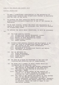
 Orbost & District Historical Society
stereoscope
... points of sight. The stereoscope was a model for the creation of the Viewfinder in the 1950's, a popular children's toy. stereoscope reynolds-edward audio-visual appliances Small stereoscope with wire rack for viewing photos. ...Used by Mr E. F. Reynolds, who conducted a hardware and tinsmith shop in Orbost until 1905. He married Elizabeth Davidson.The stereoscope became popular after being exhibited at the Crystal Palace Exhibition in London. The stereoscope is an instrument that unites images that are seen differently by each eye into one image creating a three-dimensional scene that allows the viewer to experience depth. The stereoscope is especially important to landscape photographers helping them to equally represent a landscape from two different points of sight. The stereoscope was a model for the creation of the Viewfinder in the 1950's, a popular children's toy. Small stereoscope with wire rack for viewing photos. Wooden eye mask.stereoscope reynolds-edward audio-visual appliances -
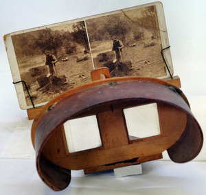
 Greensborough Historical Society
Newspaper - Newspaper Clipping - Digital Image, Diamond Valley News, It's great - if you can fly, 31/08/1971
... A view of the intersection of Sherbourne and Para Roads in Montmorency in 1971, just after it was completed. The article points...Greensborough Historical Society 34A Glenauburn Road Lower Plenty Lower Plenty melbourne A view of the intersection of Sherbourne and Para Roads in Montmorency in 1971, just after it was completed. The article points ...A view of the intersection of Sherbourne and Para Roads in Montmorency in 1971, just after it was completed. The article points out the number of poles in the photograph.Digital copy of newspaper articlesherbourne road montmorency, para road montmorency, montmorency -
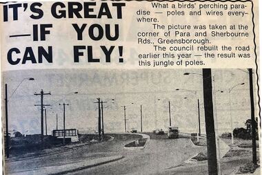
 Montmorency–Eltham RSL Sub Branch
Uniform - Helmet, Steel, Japanese, Type 92, Circa WWII
... Montmorency–Eltham RSL Sub Branch Petrie Park 16 Mountain View Road Montmorency melbourne Circa WWII type 92 Japanese steel helmet Circa WWII japanese type 92 steel helmet helmet japanese Headgear WWII Japanese steel helmet, Type 92, painted silver post-war. A five point star is soldered to the front. There are four small holes (two on either side) in the top of the helmet. A circular metal stud is located on either side of the helmet at the rear. Three liner mounting attachment points ...Circa WWII type 92 Japanese steel helmetCirca WWII japanese type 92 steel helmetWWII Japanese steel helmet, Type 92, painted silver post-war. A five point star is soldered to the front. There are four small holes (two on either side) in the top of the helmet. A circular metal stud is located on either side of the helmet at the rear. Three liner mounting attachment points are located on the inside rim of the helmet. The rim of the helmet is cracked in two places.helmet, japanese, headgear -
 Montmorency–Eltham RSL Sub Branch
Artwork, other - Trench Art - Vase, 1941
... View Road Montmorency melbourne anti-tank gun shell trench art 1941 vase Insignia - Australian Commonwealth Military Forces (collar badge). Outer edge under shell - 1941 LOT 110 RM/C 2PR No1. Inner area under shell - 1941 113 11-41 1941 40mm 2-pounder brass anti tank gun shell case made into a vase with 5 splayed points at top the casing with the collar insignia badge on front. ...1941 40mm 2-pounder brass anti tank gun shell case made into a vase with 5 splayed points at top the casing with the collar insignia badge on front.Insignia - Australian Commonwealth Military Forces (collar badge). Outer edge under shell - 1941 LOT 110 RM/C 2PR No1. Inner area under shell - 1941 113 11-41anti-tank, gun shell, trench art, 1941, vase -
 Montmorency–Eltham RSL Sub Branch
Artwork, other - Trench Art - Vase, 1941
... View Road Montmorency melbourne gun shell anti-tank trench art 1941 vase Insignia - Australian Commonwealth Military Forces (collar badge). Outer edge under shell - 1941 LOT 113 RM/C 2PR No2 Inner area under shell - 1941 110 11-41 No/2 MK1 1941 40mm 2-pounder brass anti tank gun shell case made into a vase with 5 splayed points at top the casing with the collar insignia badge on front. ...1941 40mm 2-pounder brass anti tank gun shell case made into a vase with 5 splayed points at top the casing with the collar insignia badge on front.Insignia - Australian Commonwealth Military Forces (collar badge). Outer edge under shell - 1941 LOT 113 RM/C 2PR No2 Inner area under shell - 1941 110 11-41 No/2 MK1gun shell, anti-tank, trench art, 1941, vase -
 Montmorency–Eltham RSL Sub Branch
Accessory - Money Belt, AMF Money Belt
... Montmorency–Eltham RSL Sub Branch Petrie Park 16 Mountain View Road Montmorency melbourne harrison ww2 The inscription on the brass button nearest the buckle refers to “Australian Military Forces”; and the remaining brass button has inscription too small to decipher, with a rose imprint. Brown leather money belt with metal buckle and 3 pockets secured by metal zips. Affixed to the belt is a brass regimental shoulder badge, with the initials “ RF” ( Royal Fusiliers ) and brass flaming grenade with 7 points ...Brown leather money belt with metal buckle and 3 pockets secured by metal zips. Affixed to the belt is a brass regimental shoulder badge, with the initials “ RF” ( Royal Fusiliers ) and brass flaming grenade with 7 points. Also affixed are 2 brass buttons.The inscription on the brass button nearest the buckle refers to “Australian Military Forces”; and the remaining brass button has inscription too small to decipher, with a rose imprint.harrison, ww2 -
 Montmorency–Eltham RSL Sub Branch
Flag - Australian National Flag
... Montmorency–Eltham RSL Sub Branch Petrie Park 16 Mountain View Road Montmorency melbourne Presented with Cerificate from the Speaker of the House of Representatives Neil Andrews on June 22nd 1999 polyester australian flag national The flag has three elements on a blue background: the Union Jack, the Commonwealth Star and the Southern Cross. ... Below the Union Jack is a white Commonwealth, or Federation, star. It has seven points ...Presented with Cerificate from the Speaker of the House of Representatives Neil Andrews on June 22nd 1999The flag has three elements on a blue background: the Union Jack, the Commonwealth Star and the Southern Cross. ... Below the Union Jack is a white Commonwealth, or Federation, star. It has seven points representing the unity of the six states and the territories of the Commonwealth of Australia.polyester, australian, flag, national -
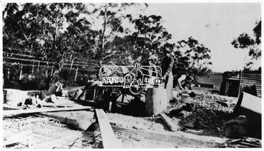 Eltham District Historical Society Inc
Negative - Photograph, Construction of the new concrete bridge over the Diamond Creek on Main Road, Eltham, c.May 1926
... Viewed from northern approach looking south east towards Eltham Park (Eltham Lower Park), showing the power lines that used to run in front of the park. The original long suspension bridge over the Diamond Creek on Main Road at Eltham collapsed during flooding of the Diamond Creek on October 13 and 14, 1923. The original bridge was built around 1840 for the coach road when Cobb & Co.'s coach was the only conveyance between Eltham and Melbourne. Widespread damage was done in Melbourne and surrounding areas by floods resulting from the overflow of the Yarra at many points...Viewed from northern approach looking south east towards Eltham Park (Eltham Lower Park), showing the power lines that used to run in front of the park. The original long suspension bridge over the Diamond Creek on Main Road at Eltham collapsed during flooding of the Diamond Creek on October 13 and 14, 1923. The original bridge was built around 1840 for the coach road when Cobb & Co.'s coach was the only conveyance between Eltham and Melbourne. Widespread damage was done in Melbourne and surrounding areas by floods resulting from the overflow of the Yarra at many points ...Construction of the new concrete bridge over the Diamond Creek on Main Road, Eltham, c.May 1926. Viewed from northern approach looking south east towards Eltham Park (Eltham Lower Park), showing the power lines that used to run in front of the park. The original long suspension bridge over the Diamond Creek on Main Road at Eltham collapsed during flooding of the Diamond Creek on October 13 and 14, 1923. The original bridge was built around 1840 for the coach road when Cobb & Co.'s coach was the only conveyance between Eltham and Melbourne. Widespread damage was done in Melbourne and surrounding areas by floods resulting from the overflow of the Yarra at many points along its banks. A temporary bridge rigged up was severely damaged by the flooding of the creek and was closed to vehicular traffic in April 1924. A new concrete bridge was constructed to replace it and by May 1926 all the concrete piles and abutments had been completed. The bridge was finally completed and opened for traffic in September 1926, almost three years after it initially collapsed.This photo forms part of a collection of photographs gathered by the Shire of Eltham for their centenary project book,"Pioneers and Painters: 100 years of the Shire of Eltham" by Alan Marshall (1971). The collection of over 500 images is held in partnership between Eltham District Historical Society and Yarra Plenty Regional Library (Eltham Library) and is now formally known as the 'The Shire of Eltham Pioneers Photograph Collection.' It is significant in being the first community sourced collection representing the places and people of the Shire's first one hundred years.Digital image 4 x 5 inch B&W Negshire of eltham pioneers photograph collection, bridge, bridge construction, cement mixer, diamond creek (creek), eltham, eltham lower park, eltham south, main road bridge -
 Eltham District Historical Society Inc
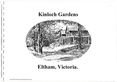
Document, Prospectus: Kinloch Gardens, Eltham Victoria, 1998c
... “Kinloch Gardens is situated on one of the highest points in Eltham and enjoys panoramic views in all directions.” ...“Kinloch Gardens is situated on one of the highest points in Eltham and enjoys panoramic views in all directions.” ...“Kinloch Gardens at Eltham, Victoria is planned as a comprehensively designed and cohesive residential environment.” “Only twelve innovatively designed houses ,will be situated within the established gardens and grounds of this historic Eltham estate. Building design and development will be under the control of the Kinloch Gardens design and construction team.” “Kinloch Gardens is situated on one of the highest points in Eltham and enjoys panoramic views in all directions.” “Kinloch Gardens lies hidden from the outside world behind high stone retaining walls, terraced embankments and extensive landscaping. The existing buildings, amongst the most significant of the Eltham / Montsalvat domestic building tradition are set in park like surrounds and enjoy panoramic views of the ranges to the north east and the city sky line to the west. New houses combined with sensitive landscaping will blend immediately into the established garden environment and will share the amenity and ambience of a very private and unique estate. The central theme of the landscape master plan is a garden reserve and a planted avenue terminating in a -small square.” “Houses vary in size from 120m2 (12.9 squares) to 210m2 (22.6 squares) (or larger) and include an extensive range of planning options. House types include: The Studio House The Tower House The Pergola House The Gallery House 'The Barn' is one of the existing buildings of Kinloch Gardens and is situated on the premium Lot 11.” Developer: Kinloch Pty Ltd. Project Managers: Creative Block Design Pty Ltd. Architects: Graeme Gunn and Ian Jelbart. Landscape Architect: Suzy Boyd. Builder: Vizarje Homes Pty Ltd. Surveyors and Engineers: Miller Merrigan.Digital file only; created from scan undertaken by EDHSarthur street, creative block design pty ltd., eltham, graeme gunn, houses, ian jelbart, kinloch gardens, kinloch pty ltd, miller merrigan, real estate, suzy boyd, vizarje homes pty ltd. -
 Eltham District Historical Society Inc
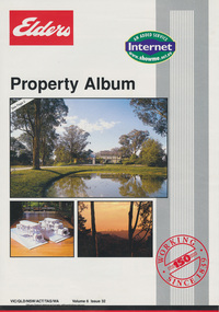
Document, Kinloch Gardens Property Album; Elders Real Estate sales material, 1998
... “Kinloch Gardens is situated on one of the highest points in Eltham and enjoys panoramic views in all directions.” ...“Kinloch Gardens is situated on one of the highest points in Eltham and enjoys panoramic views in all directions.” ...“Kinloch Gardens at Eltham, Victoria is planned as a comprehensively designed and cohesive residential environment.” “Only twelve innovatively designed houses ,will be situated within the established gardens and grounds of this historic Eltham estate. Building design and development will be under the control of the Kinloch Gardens design and construction team.” “Kinloch Gardens is situated on one of the highest points in Eltham and enjoys panoramic views in all directions.” “Kinloch Gardens lies hidden from the outside world behind high stone retaining walls, terraced embankments and extensive landscaping. The existing buildings, amongst the most significant of the Eltham / Montsalvat domestic building tradition are set in park like surrounds and enjoy panoramic views of the ranges to the north east and the city sky line to the west. New houses combined with sensitive landscaping will blend immediately into the established garden environment and will share the amenity and ambience of a very private and unique estate. The central theme of the landscape master plan is a garden reserve and a planted avenue terminating in a -small square.” “Houses vary in size from 120m2 (12.9 squares) to 210m2 (22.6 squares) (or larger) and include an extensive range of planning options. House types include: The Studio House The Tower House The Pergola House The Gallery House 'The Barn' is one of the existing buildings of Kinloch Gardens and is situated on the premium Lot 11.” Developer: Kinloch Pty Ltd. Project Managers: Creative Block Design Pty Ltd. Architects: Graeme Gunn and Ian Jelbart. Landscape Architect: Suzy Boyd. Builder: Vizarje Homes Pty Ltd. Surveyors and Engineers: Miller Merrigan.Digital file only; created from scan undertaken by EDHSarthur street, elders real estate, eltham, kinloch gardens, real estate agent, the barn -
 Eltham District Historical Society Inc
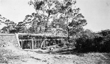
Negative - Photograph, Construction of the new concrete bridge over the Diamond Creek on Main Road, Eltham, c.May 1926
... Viewed from present day Wingrove Park. The original long suspension bridge over the Diamond Creek on Main Road at Eltham collapsed during flooding of the Diamond Creek on October 13 and 14, 1923. The original bridge was built around 1840 for the coach road when Cobb & Co.'s coach was the only conveyance between Eltham and Melbourne. Widespread damage was done in Melbourne and surrounding areas by floods resulting from the overflow of the Yarra at many points...Viewed from present day Wingrove Park. The original long suspension bridge over the Diamond Creek on Main Road at Eltham collapsed during flooding of the Diamond Creek on October 13 and 14, 1923. The original bridge was built around 1840 for the coach road when Cobb & Co.'s coach was the only conveyance between Eltham and Melbourne. Widespread damage was done in Melbourne and surrounding areas by floods resulting from the overflow of the Yarra at many points ...Construction of the new concrete bridge over the Diamond Creek on Main Road, Eltham, c.May 1926. Viewed from present day Wingrove Park. The original long suspension bridge over the Diamond Creek on Main Road at Eltham collapsed during flooding of the Diamond Creek on October 13 and 14, 1923. The original bridge was built around 1840 for the coach road when Cobb & Co.'s coach was the only conveyance between Eltham and Melbourne. Widespread damage was done in Melbourne and surrounding areas by floods resulting from the overflow of the Yarra at many points along its banks. A temporary bridge rigged up was severely damaged by the flooding of the creek and was closed to vehicular traffic in April 1924. A new concrete bridge was constructed to replace it and by May 1926 all the concrete piles and abutments had been completed. The bridge was finally completed and opened for traffic in September 1926, almost three years after it initially collapsed.This photo forms part of a collection of photographs gathered by the Shire of Eltham for their centenary project book,"Pioneers and Painters: 100 years of the Shire of Eltham" by Alan Marshall (1971). The collection of over 500 images is held in partnership between Eltham District Historical Society and Yarra Plenty Regional Library (Eltham Library) and is now formally known as the 'The Shire of Eltham Pioneers Photograph Collection.' It is significant in being the first community sourced collection representing the places and people of the Shire's first one hundred years.Digital image 4 x 5 inch B&W Neg Print 9 x 12.5 cmshire of eltham pioneers photograph collection, eltham, eltham lower park, main road bridge, eltham south, bridge, diamond creek (creek), wingrove park, bridge construction -
 Eltham District Historical Society Inc
Negative - Photograph, Bridge on Main Road, Eltham, c.1890
... points along its banks. A temporary bridge rigged up was severely damaged by the flooding of the creek and was closed to vehicular traffic in April 1924. A new concrete bridge was constructed to replace it and by May 1926 all the concrete piles and abutments had been completed. The bridge was finally completed and opened for traffic in September 1926, almost three years after it initially collapsed. Viewed...points along its banks. A temporary bridge rigged up was severely damaged by the flooding of the creek and was closed to vehicular traffic in April 1924. A new concrete bridge was constructed to replace it and by May 1926 all the concrete piles and abutments had been completed. The bridge was finally completed and opened for traffic in September 1926, almost three years after it initially collapsed. Viewed ...Possibly produced as a postcard. Caption in lower right hand corner reads: Bridge (at) Main Road Eltham. The long wooden suspension bridge over the Diamond Creek on Main Road at Eltham collapsed during flooding of the Diamond Creek on October 13 and 14, 1923. The original bridge was built around 1840 for the coach road when Cobb & Co.'s coach was the only conveyance between Eltham and Melbourne. Widespread damage was done in Melbourne and surrounding areas by floods resulting from the overflow of the Yarra at many points along its banks. A temporary bridge rigged up was severely damaged by the flooding of the creek and was closed to vehicular traffic in April 1924. A new concrete bridge was constructed to replace it and by May 1926 all the concrete piles and abutments had been completed. The bridge was finally completed and opened for traffic in September 1926, almost three years after it initially collapsed. Viewed from Antoinette Boulevard looking northwest towards Falkiner Street. The building in the distance believed to be Souters Cottage. On the far right on the very edge of the road verge are two Eucalypt trees, one of which is believed to be the large dead trunk still standing in present day.This photo forms part of a collection of photographs gathered by the Shire of Eltham for their centenary project book,"Pioneers and Painters: 100 years of the Shire of Eltham" by Alan Marshall (1971). The collection of over 500 images is held in partnership between Eltham District Historical Society and Yarra Plenty Regional Library (Eltham Library) and is now formally known as the 'The Shire of Eltham Pioneers Photograph Collection.' It is significant in being the first community sourced collection representing the places and people of the Shire's first one hundred years.Digital image 4 x 5 inch B&W Neg Black and white print 35mm positive transparencyshire of eltham pioneers photograph collection, eltham, main road bridge, eltham south, bridge, diamond creek (creek), significant tree, souters cottage, eltham lower park, main road, sepp -
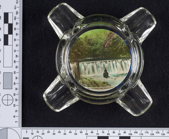 Melbourne Water
Ashtray, Graceburn Weir, Healesville Souvenir, 1930s-1940s
... This souvenir item has been curated by Melbourne Water as it represents an important historical aspect of the organisation by demonstrating the popularity of its water asset sites as recreational places and tourist attractions, and although these sites are functional parts of the water supply system, they were also designed to be enjoyed by the public both aesthetically and recreationally. melbourne metropolitan board of works, mmbw, maroondah, dam, healesville, melbourne water, scenic view, souvenir, glass, ashtray graceburnweir This Souvenir glass ashtray, used as a receptacle for ash from cigarettes, features a photograph of the Graceburn Weir on the base, with text reading “The Graceburn Weir, Healesville”. Rather small in size, this ashtray has a unique shape with four protruding glass points ...The Maroondah System was first and foremost developed as a functional component of Melbourne's Water Supply System. In addition to functionality, the Melbourne and Metropolitan Board of Works (MMBW) envisioned the Maroondah Reserve to be enjoyed aesthetically and recreationally by the public. This souvenir illustrates the realisation of the Maroondah System as a local recreational and tourist attraction in the early 20th century. The Maroondah Reserve gardens were landscaped with English-style ornamental stonework, exotic trees, flower beds and rose gardens. All features of the water supply system became widely celebrated as beauty spots that continue to be very popular to this day with tourists and locals alike. This souvenir is a product of that flourishing tourist trade. These water supply sites continue to enhance Melbourne’s charm and liveability and are now recognised as places of cultural and historic significance.This souvenir item has been curated by Melbourne Water as it represents an important historical aspect of the organisation by demonstrating the popularity of its water asset sites as recreational places and tourist attractions, and although these sites are functional parts of the water supply system, they were also designed to be enjoyed by the public both aesthetically and recreationally.This Souvenir glass ashtray, used as a receptacle for ash from cigarettes, features a photograph of the Graceburn Weir on the base, with text reading “The Graceburn Weir, Healesville”. Rather small in size, this ashtray has a unique shape with four protruding glass points to place cigarettes. melbourne metropolitan board of works, mmbw, maroondah, dam, healesville, melbourne water, scenic view, souvenir, glass, ashtray, graceburnweir -
Ringwood and District Historical Society
Document, Notes for Historical Hike of Heathmont by Frank Secomb with assistance from Doug Muller, January 1994
... Description of an historical walk with various points of interest in Heathmont including relating to Pump, Wieland, Sharp, Muller, Bennett, Charm View Estate, Washusens etc. ...Description of an historical walk with various points of interest in Heathmont including relating to Pump, Wieland, Sharp, Muller, Bennett, Charm View Estate, Washusens etc. ...A4 document typed document (photocopy). Based on Recollections of Early Heathmont by Frank Secomb with Assistance from Doug Muller. Description of an historical walk with various points of interest in Heathmont including relating to Pump, Wieland, Sharp, Muller, Bennett, Charm View Estate, Washusens etc. -
 Glenelg Shire Council Cultural Collection
Artwork, other - Illustration, n.d
... View of Bentinck Street Portland Victoria from old London corner, looking south towards Macs Hotel. Scene depicts street life, horse and carts, a man in a top hat, coat and walking cane points south. ...View of Bentinck Street Portland Victoria from old London corner, looking south towards Macs Hotel. Scene depicts street life, horse and carts, a man in a top hat, coat and walking cane points south. ...Illustration. Taken and cut from a book. Image is not bordered. View of Bentinck Street Portland Victoria from old London corner, looking south towards Macs Hotel. Scene depicts street life, horse and carts, a man in a top hat, coat and walking cane points south. Two lady's in dresses with an umbrella talk on the corner and various individuals gather out the front of the Old London. Trailer of ivy, top left section. Printed bottom middle BENTINCK STREET, PORTLAND.Front: 'BENTINCK STREET, PORTLAND' - printed, lower edge.bentinck street, city of portland, old london