Showing 269 items matching " campus map"
-
 Creswick Campus Historical Collection - University of Melbourne
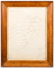
Map - Campus map, framed, Fire Protection Map, 1969-1974
... Campus map, framed...Campus Building 719/718 Creswick goldfields VSF Fire protection Plan. Framed. Prepared in interval between construction of Science Block and commencement of Certificate Courses (1969-1974) (Bob Orr) fire protection victorian school of forestry creswick Hand drawn map of the School of Forestry showing fire protection services in a Wooden frame with glass cover Fire Protection Map Map Campus map, framed Victorian School of Forestry ...VSF Fire protection Plan. Framed. Prepared in interval between construction of Science Block and commencement of Certificate Courses (1969-1974) (Bob Orr)Hand drawn map of the School of Forestry showing fire protection services in a Wooden frame with glass coverfire protection, victorian school of forestry, creswick -
 Glen Eira Historical Society
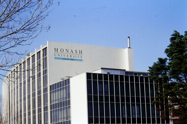
Article - MONASH UNIVERSITY CAULFIELD CAMPUS
... ... Campus Map...NHArchitecture Altoon and Porter (Master Planner and Urban Designer ) Huczek Wojciech (Architect) Lipsys Andrius (Photographer) Martens Karel Station Square Development Campus Map Derby Lane Princess Lane Post Office Place Caulfield Station Sir John Monash Drive Derby Road The Hub The Mat Post Office Square Station Square Zagame’s Hotel Dandenong Road OASE 33 Art and Design Building Monash University Caulfield Campus Caulfield East Universities Tertiary Education Article MONASH UNIVERSITY CAULFIELD CAMPUS ...This folder contains 6 items about this educational institution: 1/Undated colour slides showing various angles of two different building facades of Monash Caulfield Campus. 2/Article 'Martens Matters' re launch of exhibition of covesr of OASE 33 Magazine by Designer Karel Martens. Date noted as 01/04/2011 in 'The Age'. 3/Collection of 6 separate cards, all Priority Development Panel Submissions, Design Visualization, dated May 2006 (Architectural drafts) dated 31/03/2006 plus 2 identical cards dated 01/05/2006 - all drawings and one plan for NHArchitecture. 4/Collection of 4 colour separate cards, all Priority Development Panel Submissions, Design Visualization for Architect Wojciech Huszek of existing buildingsdated 31/03/2006. 5/Collection of 4 colour separate cards all Priority Development Panel Submissions, Design Visualization of existing buildings by photographer Andrius Lipsys, dated March 2006. (No architect stated.) 6/Article 'Uni rank sign of the Times' from Glen Eira Port Phillip Leader dated 12/03/2013 concerning Monash University’s world ranking in 100 best universities.nharchitecture, altoon and porter (master planner and urban designer ), huczek wojciech (architect), lipsys andrius (photographer), martens karel, station square development, campus map, derby lane, princess lane, post office place, caulfield station, sir john monash drive, derby road, the hub, the mat, post office square, station square, zagame’s hotel, dandenong road, oase 33, art and design building, monash university, caulfield campus, caulfield east, universities, tertiary education -
 Federation University Historical Collection
Letter - Photocopy of letter, Letter regarding the naming of Vincent Drive, Mount Helen, 1984, 1984
... Photograph of letter plus a Ballarat University campus map showing Vincent Drive, plus a newspaper clipping and photocopy of the clipping regarding a new access road to the Ballarat Technology Park ( The Courier, Ballarat, Tuesday, March 19,1996)....Vincent Drive was named in recognition of the years of service Richard Vincent gave to the Shire of Buninyong as a councillor. vincent drive federation university buninyong shire ballarat university ballarat technology park Photograph of letter plus a Ballarat University campus map showing Vincent Drive, plus a newspaper clipping and photocopy of the clipping regarding a new access road to the Ballarat Technology Park ( The Courier, Ballarat, Tuesday, March 19,1996). ...Provides information about the naming of Vincent Drive Ballarat University 1984. Vincent Drive was named in recognition of the years of service Richard Vincent gave to the Shire of Buninyong as a councillor.Photograph of letter plus a Ballarat University campus map showing Vincent Drive, plus a newspaper clipping and photocopy of the clipping regarding a new access road to the Ballarat Technology Park ( The Courier, Ballarat, Tuesday, March 19,1996).vincent drive, federation university, buninyong shire, ballarat university, ballarat technology park -
NMIT (Northern Melbourne Institute of TAFE)
Report: Campuses, buildings and rooms - Layouts and listings July 1994 NMCOT
... Consists mainly of campus location maps and room layout plans by building. ...Consists mainly of campus location maps and room layout plans by building. ...Spiral bound report of 284 pages, A4 size. Consists mainly of campus location maps and room layout plans by building. Prepared by Neville Lester for Northern Metropolitan College of TAFE.northern metropolitan college of tafe, buildings, reports, nmit -
 NMIT (Northern Melbourne Institute of TAFE)
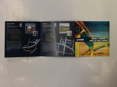
Brochure - NMIT, What's where and how to get there, 2004
... This brochure lists areas of study available at each of NMIT's campuses around Victoria. Includes maps and photos of NMIT campuses....Includes maps and photos of NMIT campuses....NMIT (Northern Melbourne Institute of TAFE) This brochure lists areas of study available at each of NMIT's campuses around Victoria. Includes maps and photos of NMIT campuses. nmit campuses nmit Small colour brochure, folds five pages into a square. ...This brochure lists areas of study available at each of NMIT's campuses around Victoria. Includes maps and photos of NMIT campuses.Small colour brochure, folds five pages into a square. Includes maps and photos of NMIT campuses.nmit campuses, nmit, -
 Federation University Historical Collection
Book - Handbook, University of Ballarat Handbook, 1995, 1995
... Barker Library Regulations, Appeals, Non-Sexist language, Student discipline, Academic Board Policy, Student Union, Enrolment, Parking, Campus plan, Locality map....Barker Library Regulations, Appeals, Non-Sexist language, Student discipline, Academic Board Policy, Student Union, Enrolment, Parking, Campus plan, Locality map. University of Ballarat Handbook, 1995 Book Handbook ...The University of Ballarat was formed in 1994, and is a predecessor organisation of Federation University Australia. White covered book with blue and maroon printing and logo. Information includes staff, admission policies and procedures, fees, Aboriginal and Torres Strait Islander Students, Scholarships, accomodation, International Students, courses, units, academic regulations, E.J. Barker Library Regulations, Appeals, Non-Sexist language, Student discipline, Academic Board Policy, Student Union, Enrolment, Parking, Campus plan, Locality map.university of ballarat handbook, courses, student association, marg thorne, mary rhyne, vicki anwyl, jenny geddes, wendy keyte, lynne billstone-convery, toni palmer, mary williams, steve blomeley, jenny gallagher, tracey fox -
 Warrnambool and District Historical Society Inc.
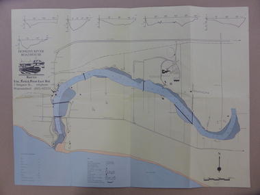
Map - An Angler's map of the Hopkins River Estuary, Angler's map Hopkins River, 1980s
... The map has been produced by the Warrnambool Institute of Advanced Education which was developed in the late 1960s from the tertiary section of the Warrnambool Technical College and with all its departments established by 1984 at the Sherwood Campus five kilometres from Warrnambool on the Princes Highway. ...campus. The Warrnambool Anglers’ Club has its headquarters on the banks of the Hopkins River near the mouth of the river and the Lyndoch Aged Care facility. This map ...This is a map of the Hopkins River Estuary prepared by Dr John Sherwood for the benefit of anglers. The information on the sheet includes the location of sand banks, the water depths, boat ramp facilities and public access facilities. Some of the information has been gathered from aerial photographs. The map has been produced by the Warrnambool Institute of Advanced Education which was developed in the late 1960s from the tertiary section of the Warrnambool Technical College and with all its departments established by 1984 at the Sherwood Campus five kilometres from Warrnambool on the Princes Highway. Today the site is occupied by Deakin University, Warrnambool campus. The Warrnambool Anglers’ Club has its headquarters on the banks of the Hopkins River near the mouth of the river and the Lyndoch Aged Care facility.This map is of interest as a specialist one, providing fishermen with detailed information on all aspects of the Hopkins river estuary. Fishing has been both a profession and a popular recreational pursuit for Warrnambool residents since the early days of the city’s settlement. The Hopkins River Estuary has been a focal point for fishermen throughout Warrnambool’s history. This is a sheet of paper folded three times to produce a folded map. The front cover has a black and white photograph of two fishermen with a large fish. The map of the Hopkins River Estuary is in yellow, blue and black and covers the side of one sheet and three quarters of the other side. There is an advertisement for the Hopkins River Boathouse with a black and white sketch of the boathouse and notes on the map written by Dr John Sherwood. There are several diagrams showing the water depths. The map has some silverfish damage and some tearing at the folds. warrnambool anglers’ club, history of warrnambool, hopkins river, hopkins river estuary, john sherwood -
 Warrnambool and District Historical Society Inc.
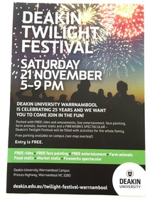
Document, Deaking Twilight Festival, 2015
... The other side has a white background with green and black printed material and a map of Deakin University Warrnambool campus. ...Campus of that university. This brochure is of interest as a memento of the 25th anniversary celebrations of Deakin University Warrnambool. Deakin University Warrnambool Education in Warrnambool Warrnambool History This is a single sheet of paper advertising the Deakin University Twilight Festival in November 2015. One side has a black background with a coloured image of people watching a fireworks display and white printed material on a black and green background. The other side has a white background with green and black printed material and a map ...This is a brochure advertising the Twilight Festival at Deakin University, Warrnambool Campus, in November 2015. The festival was held to celebrate the 25th anniversary of the founding of the Warrnambool Campus of Deakin University in 1990. The Warrnambool Institute of Advanced Education had previously occupied the site at Sherwood Park and in 1990 the Institute merged with Deakin University to form the Warrnambool Campus of that university. This brochure is of interest as a memento of the 25th anniversary celebrations of Deakin University Warrnambool. This is a single sheet of paper advertising the Deakin University Twilight Festival in November 2015. One side has a black background with a coloured image of people watching a fireworks display and white printed material on a black and green background. The other side has a white background with green and black printed material and a map of Deakin University Warrnambool campus. deakin university warrnambool, education in warrnambool, warrnambool history -
 Warrnambool and District Historical Society Inc.
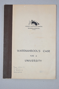
Booklet, Warrnambool's Case for a university, 1961
... campus at Sherwood Park after a merger with the Warrnambool Institute of Advanced Education. This booklet has some historical significance as it contains the information collated on the campaign in Warrnambool and the Western District for a university to be established in the Warrnambool area. deakin university history of warrnambool This is a soft cover booklet of 48 pages. It has a beige-coloured cover with black printing. The booklet has been bound with brown tape. It has printed information, black and white photographs, a fold-out map ...The information in this booklet was prepared by a University Investigation Committee formed in Warrnambool in 1961 to present the case for the establishment of a university in the Warrnambool area. The chairman of this committee was the Mayor of Warrnambool, Cr P. O’Sullivan and the secretary was W. L. George of Warrnambool. This submission was unsuccessful at the time but campaigning for a university continued. In 1961 Warrnambool Technical School in Timor Street was offering both secondary and tertiary courses in the technical and trades areas and in 1969 the tertiary section of this Technical School became the Warrnambool Institute of Advanced Education. The tertiary section was relocated in 1984 to Sherwood Park, a 94 hectare site on the Princes Highway five kilometres from Warrnambool’s C.B.D. In 1990 Deakin University established a regional campus at Sherwood Park after a merger with the Warrnambool Institute of Advanced Education. This booklet has some historical significance as it contains the information collated on the campaign in Warrnambool and the Western District for a university to be established in the Warrnambool area.This is a soft cover booklet of 48 pages. It has a beige-coloured cover with black printing. The booklet has been bound with brown tape. It has printed information, black and white photographs, a fold-out map, graphs and tables.deakin university, history of warrnambool -
Federation University Historical Collection
Plan, Federation University Mount Helen Campus, 2022, 2022
... A map showing the layout of buildings, roads and carparks on the Federation University Mount Helen Campus....Barker Library (top floor) Mount Helen goldfields Federation University Mount Helen Campus Campus Plan Founders Theatre Albert Coates Centre Student accomodation student residences Albert Coates Complex APRETC Tower Caro Convention Centre Helath and Sports Precinct Fedliving E.J. .Barker Library Aboriginal Education Centre Bai Err Murnong Geoffrey Blainey Research Centre Swimming Pool International Student Support Fed Children's Centre Muslim Prayer Room acquatic centre herbert werner frederick de nully Peter Lalor Hall Bella Guerin Hall A map showing the layout of buildings, roads and carparks on the Federation University Mount Helen Campus. ...A map showing the layout of buildings, roads and carparks on the Federation University Mount Helen Campus.federation university mount helen campus, campus plan, founders theatre, albert coates centre, student accomodation, student residences, albert coates complex, apretc tower, caro convention centre, helath and sports precinct, fedliving, e.j. .barker library, aboriginal education centre, bai err, murnong, geoffrey blainey research centre, swimming pool, international student support, fed children's centre, muslim prayer room, acquatic centre, herbert werner frederick de nully, peter lalor hall, bella guerin hall -
Federation University Historical Collection
Map, Aboriginal Language Areas in Victoria: A Reconstruction
... Campus Federation University Australia E.J. Barker Library (top floor) Mount Helen goldfields Aboriginal Aboriginal Language Victoria Djadja Wurrung Woi Wurrung Watha Wurrung Gadubanud Girai Wurrung Dhauwurd Wurrung djab wurrung wiradjuri Tatungalung WadiWadi Dadidadi Yuyu A4 sized map of Victoria showing Aboriginal Langauge Areas. ...A4 sized map of Victoria showing Aboriginal Langauge Areas. Black, white and red writing aboriginal, aboriginal language, victoria, djadja wurrung, woi wurrung, watha wurrung, gadubanud, girai wurrung, dhauwurd wurrung, djab wurrung, wiradjuri, tatungalung, wadiwadi, dadidadi, yuyu -
 Federation University Historical Collection
Document - Document - Tourist Guide, Jeff Zilles, ZILLES COLLECTION: Your Guide to Galleries Antique and Craft Shops in Ballarat, c1984
... Campus Federation University Australia E.J. Barker Library (top floor) Mount Helen goldfields Zilles Printers was begun by Lewis Zilles in the early 1930s. It was in McKenzie Street Ballarat. His son Jeffrey also became a printer - letterpress, offset and screen printer. The business became Zilles Printers/Graphics and was in Armstrong Street and later Bell Street Ballarat. Tourist guide listing Galleries, Antique and Craft shops in Ballarat. Reverse side show map ...Zilles Printers was begun by Lewis Zilles in the early 1930s. It was in McKenzie Street Ballarat. His son Jeffrey also became a printer - letterpress, offset and screen printer. The business became Zilles Printers/Graphics and was in Armstrong Street and later Bell Street Ballarat. Tourist guide listing Galleries, Antique and Craft shops in Ballarat. Reverse side show map and locationsBuff coloured paper printing in red inkantiques, map, zilles, ballarat, gallaries, craft shops -
Federation University Historical Collection
Map - Ephemera, Melbourne City Tourist Shuttle, c2006
... Campus Federation University Australia E.J. Barker Library (top floor) Mount Helen goldfields John So was Mayor of Melbourne from 2001-2008 Melbourne Southbank Melbourne Docks Fitzroy Carlton East Melbourne John So A brochure with a map of the Melbourne Central Business District. ...John So was Mayor of Melbourne from 2001-2008A brochure with a map of the Melbourne Central Business District.melbourne, southbank, melbourne docks, fitzroy, carlton, east melbourne, john so -
 Federation University Historical Collection
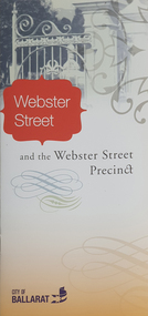
Ephemera - Map, Webster Street Precinct, c2010
... Campus Federation University Australia E.J. Barker Library (top floor) Mount Helen goldfields The Webster Street Precinct was actively mined during the 1850s. By the 1860s cottages had been built along the street and became fashionable. Webster Street Ballarat Architecture Peplow HOuse Cairnhurst Roffensis timeline NOvar Glenholme Trerelffe Banyena Balderton Locksley Trelawne A small pamphlet outlining houses in Webster Street, Ballarat. Webster Street Precinct Ephemera Map ...The Webster Street Precinct was actively mined during the 1850s. By the 1860s cottages had been built along the street and became fashionable.A small pamphlet outlining houses in Webster Street, Ballarat.webster street ballarat, architecture, peplow house, cairnhurst, roffensis, timeline, novar, glenholme, trerelffe, banyena, balderton, locksley, trelawne -
Federation University Historical Collection
Programme, Ballarat Heritage Weekend - Mothers Day 8-9 May 2010
... Barker Library (top floor) Mount Helen goldfields Federation University has a Campus in Ballarat and therefore Ballarat's Heritage is significant Ballarat Heritage Weekend Judy Verlin The George Hotel Craig's Royal Hotel Old Colonists' Club Sovereign Hill Ballarat Railway Station Sturt Street Her Majesty's Theatre Maps Ballarat Town Hall City of Ballarat Ballarat Mining Exchange Programme outlining events and places of interest for Ballarat Heritage Weekend May 2010 Ballarat Heritage Weekend - Mothers Day 8-9 May 2010 Programme ...Federation University has a Campus in Ballarat and therefore Ballarat's Heritage is significantProgramme outlining events and places of interest for Ballarat Heritage Weekend May 2010ballarat heritage weekend, judy verlin, the george hotel, craig's royal hotel, old colonists' club, sovereign hill, ballarat railway station, sturt street, her majesty's theatre, maps, ballarat town hall, city of ballarat, ballarat mining exchange -
 Federation University Historical Collection
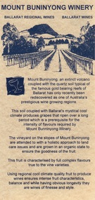
Card - Card - Advertising, ZILLES COLLECTION: Advertising Card promoting Mount Buninyong Winery
... Campus Federation University Australia E.J. Barker Library (top floor) Mount Helen goldfields Zilles Printers was begun by Lewis Zilles in the early 1930s. It was in McKenzie Street Ballarat. His son Jeffrey also became a printer - letterpress, offset and screen printer. The business became Zilles Printers/Graphics and was in Armstrong Street and later Bell Street Ballarat. Mount Buninyong has become one of Victoria's prestigious wine growing areas due to the soil and the climate. zilles printers ballarat mount buninyong winery Double-sided light beige card with black print. Map ...Zilles Printers was begun by Lewis Zilles in the early 1930s. It was in McKenzie Street Ballarat. His son Jeffrey also became a printer - letterpress, offset and screen printer. The business became Zilles Printers/Graphics and was in Armstrong Street and later Bell Street Ballarat. Mount Buninyong has become one of Victoria's prestigious wine growing areas due to the soil and the climate. Double-sided light beige card with black print. Map showing location.zilles printers, ballarat, mount buninyong, winery, -
Federation University Historical Collection
Book - Astronomy, Richard A. Proctor, Other Worlds Than Ours: The Plurality of Worlds Studied under the Light of Recent Scientific Researches, 1878
... Campus Federation University Australia E.J. Barker Library (top floor) Mount Helen goldfields THis book was no 388 in the Evansford Public Library. astronomy planets telescope earth sun jupitar saturn uranus neptune moon meteors comets solar system nebulae galaxies milky way Richard Anthony Proctor (23 March 1837 – 12 September 1888) was an English astronomer who produced one of the earliest maps of Mars in 1867 from 27 drawings by the English observer William Rutter Dawes. ...Richard Anthony Proctor (23 March 1837 – 12 September 1888) was an English astronomer who produced one of the earliest maps of Mars in 1867 from 27 drawings by the English observer William Rutter Dawes. He used old drawings of Mars dating back to 1666 to try to determine the sidereal day of Mars. His final estimate, in 1873, was 24h 37m 22.713s, very close to the modern value of 24h 37m 22.663s. Proctor was already a well-known populariser of science when he published this book, joining a ferocious debate about the possibility of life on other planets. The crater Proctor on Mars is named after him.Red hard covered book of 318 pages. Includes early images of planets as seen through a J. Browning Telescope. Proctor discusses Victorian discoveries about the solar system and describes what was then known about each of the planets. He evaluates the habitability of Mars, Jupiter, Mercury, Venus and Saturn in the light of his belief in the possibility of extraterrestrial life. The text includes many illustrations of the planets, a spectacular map of Mars, and theoretical views of the Milky Way. Influenced by Darwin, Proctor had a teleological view of the universe and believed that eventually the cosmos would be filled with living things. non-fictionRichard Anthony Proctor (23 March 1837 – 12 September 1888) was an English astronomer who produced one of the earliest maps of Mars in 1867 from 27 drawings by the English observer William Rutter Dawes. He used old drawings of Mars dating back to 1666 to try to determine the sidereal day of Mars. His final estimate, in 1873, was 24h 37m 22.713s, very close to the modern value of 24h 37m 22.663s. Proctor was already a well-known populariser of science when he published this book, joining a ferocious debate about the possibility of life on other planets. The crater Proctor on Mars is named after him.astronomy, planets, telescope, earth, sun, jupitar, saturn, uranus, neptune, moon, meteors, comets, solar system, nebulae, galaxies, milky way -
 Federation University Historical Collection
Map, Geological Map (Southern Western Australia), post 1880
... Campus Federation University Australia E.J. Barker Library (top floor) Mount Helen goldfields Includes the routes of exploration, including E. Giles, A. W. Howitt, Burke & Wills, Hume & Hovell, Major Mitchell, A Forrest. geology exploration railways electric telegraphs A section of a map showing geology and routes of exploration. ...Includes the routes of exploration, including E. Giles, A. W. Howitt, Burke & Wills, Hume & Hovell, Major Mitchell, A Forrest.A section of a map showing geology and routes of exploration. Southern Western Australia only geology, exploration, railways, electric telegraphs -
 Federation University Historical Collection
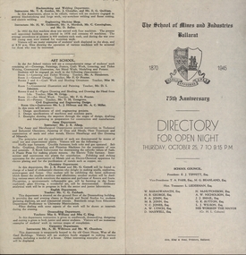
Programme, School of Mines: 75th Anniversary, Directory for Open Night, 1945, 1945
... Campus Federation University Australia E.J. Barker Library (top floor) Mount Helen goldfields To celebrate the 75th Anniversary of the School of Mines and Industries an Open Night was held on Thursday, October 25 (1945) from 7 to 9.15 p.m. The Principal was Mr A Heseltine and the Registrar was Mr F Ferguson. Members of the School Council included E J Tippett, M G Beanland who have a building or walkway named after them. A map ...To celebrate the 75th Anniversary of the School of Mines and Industries an Open Night was held on Thursday, October 25 (1945) from 7 to 9.15 p.m. The Principal was Mr A Heseltine and the Registrar was Mr F Ferguson. Members of the School Council included E J Tippett, M G Beanland who have a building or walkway named after them. A map of the buildings shows the various areas and information is given for each department. Though it was an Open Night it would also serve as an Information Night for student enrolling for the following year.Paper folded in half and printed on each of the four sections. Map showing layout of buildings. Information on each department of the school.ballarat school of mines and industries, 75 anniversary, a heseltine, principal, f e ferguson, registrar, e j tippett, m g beanland, open night, information night -
 Federation University Historical Collection
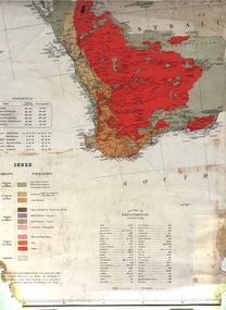
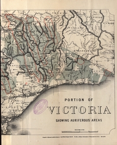
Map - Map and Information, Department of Mines: Map and Suggestions to Prospectors, 1891
... Federation University Historical Collection Federation University Australia, Mt Helen Campus Federation University Australia E.J. Barker Library (top floor) Mount Helen goldfields The map outlines the auriferous (gold bearing) areas in Victoria. ...The map outlines the auriferous (gold bearing) areas in Victoria. The information for prospectors was prepared by the Department of Mines in 1894Document: 4 page type written Map: Portion of Victoria divided into Counties of 1891. Auriferous areas with red.Reference section on mapgold, auriferous areas, department of mines, victoria, map of victoria, prospectors, commissioner of crown lands, hon a mclean, alexander black, surveyor general, a mclean -
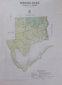 Federation University Historical Collection
Map, Broadlands, County of Dargo, 1887
... Campus Federation University Australia E.J. Barker Library (top floor) Mount Helen goldfields broadford j.g. easton DARGO GEOLOGICAL Plan of Broadlands, County of Dargo, Victoria. Broadlands, County of Dargo Map ...Plan of Broadlands, County of Dargo, Victoria.broadford, j.g. easton, dargo, geological -
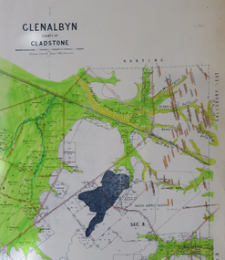 Federation University Historical Collection
Map, Glenalbyn, County of Gladstone
... Campus Federation University Australia E.J. Barker Library (top floor) Mount Helen goldfields glenalbyn county of gladstone tarnagulla inglewood kingower kurting old inglewood deep lead salisbury west Copy of a geological map of Glenalbyn. ...Copy of a geological map of Glenalbyn. Some areas have been colours green. Creeks have been coloured blue, roads and reefs have been coloured orange.glenalbyn, county of gladstone, tarnagulla, inglewood, kingower, kurting, old inglewood deep lead, salisbury west -
Federation University Historical Collection
Map, Central Ballarat Retail and Business Guide, 2003, 07/2003
... Campus Federation University Australia E.J. Barker Library (top floor) Mount Helen goldfields scarsdale grenville krause browns and scarsdale mopianimum watershed yarrowee woady yalloak timber reserve department of mines plans cgt crown lands ferdinand krause Map of Central Ballarat Streets, Central Square, Bridge Mall Shopping Centre and Creswick Plaza, with a legend of businesses and locations. ...Map of Central Ballarat Streets, Central Square, Bridge Mall Shopping Centre and Creswick Plaza, with a legend of businesses and locations. scarsdale, grenville, krause, browns and scarsdale, mopianimum, watershed, yarrowee, woady yalloak, timber reserve, department of mines, plans, cgt, crown lands, ferdinand krause -
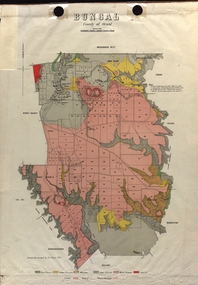 Federation University Historical Collection
Map - Plan, E.J. Dunn, Bungal County of Grant Parish Plan
... Campus Federation University Australia E.J. Barker Library (top floor) Mount Helen goldfields E.J. Dunn was the surveyor of this parish plan. plan bungal bungeltap black horse co. egerton egerton mount egerton sister rose shaft south learmonth co Kerrit Bareet Bungaeeltap Yaloak Eastern Moorabool River Corong Bungal Station Preemptive Right Lal Lal Western Moorabool River Moorabool Rover Borhoneychurck Mount Egerton Battery Bungal Creek Colour geological plan of Bungal in the County of Grant, Victoria. The areas circled in red ar craters. Bungal County of Grant Parish Plan Map ...E.J. Dunn was the surveyor of this parish plan.Colour geological plan of Bungal in the County of Grant, Victoria. The areas circled in red ar craters.plan, bungal, bungeltap, black horse co. egerton, egerton, mount egerton, sister rose shaft, south learmonth co, kerrit bareet, bungaeeltap, yaloak, eastern moorabool river, corong, bungal station preemptive right, lal lal, western moorabool river, moorabool rover, borhoneychurck, mount egerton battery, bungal creek -
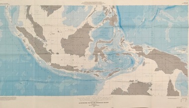 Federation University Historical Collection
Map - Geological, U.S. Government Printing Office, Bathymetric Map of the Indonesian Region: Folio of the Indonesian Region Map I-875-A, 1974, 1974
... Federation University Historical Collection Federation University Australia, Mt Helen Campus Federation University Australia E.J. Barker Library (top floor) Mount Helen goldfields Map was prepared on behalf of the Government of Indonesia, The United Nations Economic Commission for Asia and the Far East, the Agency for International Development and the U.S. ...Map was prepared on behalf of the Government of Indonesia, The United Nations Economic Commission for Asia and the Far East, the Agency for International Development and the U.S. Department of State in cooperation with the Geological Survey of Indonesia. The area covered shows the islands and seas from Latitude 12 degree North to 16 degrees South and Longitude 90 degrees to 148 degrees. Various water features are also named.Large map showing the Indonesian area - islands and seasLongitude and Latitude are shown. Major / Capitol cities indicated. Names of those responsible for the productionindonesia, united nations economic commission, department of state, geological survey, latitude, longitude, government of indonesia -
 Federation University Historical Collection
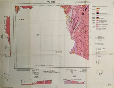
Map - Geological, Tallangatta, New South Wales: 1:250,000 Geological Series, SJ 55-3, 1966, 1966
... Campus Federation University Australia E.J. Barker Library (top floor) Mount Helen goldfields Compiled by the Geological Survey of N.S.W., Division of Regional Geology. Topographical base compiled from Snowy Mountains Hydro Electrical Authority, Department of Lands, County maps and Snowy Lease Map. ...Compiled by the Geological Survey of N.S.W., Division of Regional Geology. Topographical base compiled from Snowy Mountains Hydro Electrical Authority, Department of Lands, County maps and Snowy Lease Map. Other sheet adjoin this map. There are 13 formation sections grouped into 9 - Quaternary, Tertiary, Middle Devonian, Lower to Middle Devonian, Lower Devonian, Upper Silurian, Silurian, Upper Ordovician and Ordovician.Large coloured map showing geological features, faults, bores, rivers and mineral deposits.Scale of map, longitude and latitude, river names. "Tallangatta 1:250,00" written in black pen.tallangatta, new south wales, geological survey, topographical base, snowy mountains hydro electrical authority, department of lands, snowy lease map, department of mines, quaternary, tertiary, middle devonian, lower to middle devonian, lower devonian, uper siluran, silurian, upper ordovician, ordovician -
 Federation University Historical Collection
Map - Geological, Arnham Bay-Cove, Northern Territory: 1:250,000 Geological Series SD 53,4, 1968
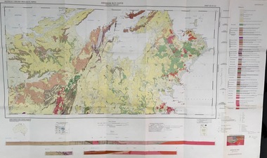
... Campus Federation University Australia E.J. Barker Library (top floor) Mount Helen goldfields Arnham Bay-Cove, Northern Territory: 1:250,000 Geological Series SD 53,4, 1968 Map - Geological ... -
 Federation University Historical Collection
Map - Geological, Nova Scotia Department of Natural Resources, Kejimkujik Lake, Nova Scotia: Geological Map 94-05, 1994
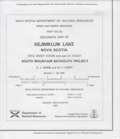
... Campus Federation University Australia E.J. Barker Library (top floor) Mount Helen goldfields Produced b Nova Scotia Department of Natural Resources, Mines and Energy Branches. The Minister of the Department was the Honourable Donald R Downe and the Deputy Minister was Darrell D Hiltz nova scotia kejimkujik lake geological survey cartography mine and energy branches donald r downe minister darrell d hiltz deputy mnister south mountain batholith project legend symbols Symbols Large coloured map depicting different areas and deposits. ...Produced b Nova Scotia Department of Natural Resources, Mines and Energy Branches. The Minister of the Department was the Honourable Donald R Downe and the Deputy Minister was Darrell D HiltzLarge coloured map depicting different areas and deposits. Includes a legend, symbols used, mineral abbreviations and alteration abbreviations.Symbolsnova scotia, kejimkujik lake, geological survey, cartography, mine and energy branches, donald r downe, minister, darrell d hiltz, deputy mnister, south mountain batholith project, legend, symbols -
Federation University Historical Collection
Map - Map - Geological, Kejimkujik Lake, Nova Scotia: Geological Map 94-05, 1994
... Campus Federation University Australia E.J. Barker Library (top floor) Mount Helen goldfields Produced by Nova Scotia Department of Natural Resources, Mines and Energy Branches. The Minister of the Department was the Honourable Donald R Downe and the Deputy Minister was Darrell D Hiltz Kejimkujik Lake Nova Scotia Symbols Large coloured map depicting different areas and deposits. ...Produced by Nova Scotia Department of Natural Resources, Mines and Energy Branches. The Minister of the Department was the Honourable Donald R Downe and the Deputy Minister was Darrell D HiltzLarge coloured map depicting different areas and deposits. Includes a legend, symbols used, mineral abbreviations and alteration abbreviations.Symbolskejimkujik lake, nova scotia -
 Federation University Historical Collection
Map - Geological, Kejimkujik Lake, Nova Scotia: Glacial and Till Clast Geology: Map 94-12, 1994
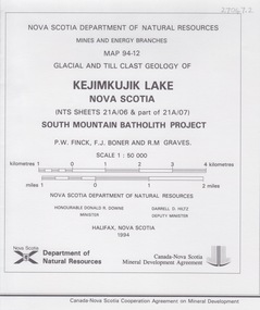
... Campus Federation University Australia E.J. Barker Library (top floor) Mount Helen goldfields Produced b Nova Scotia Department of Natural Resources, Mines and Energy Branches. The Minister of the Department was the Honourable Donald R Downe and the Deputy Minister was Darrell D Hiltz Symbols Large coloured map depicting different areas and deposits. ...Produced b Nova Scotia Department of Natural Resources, Mines and Energy Branches. The Minister of the Department was the Honourable Donald R Downe and the Deputy Minister was Darrell D HiltzLarge coloured map depicting different areas and deposits. Includes a legend, symbols used, mineral abbreviations and alteration abbreviations.Symbols