Showing 2623 items matching " canning street"
-
 Sunshine and District Historical Society Incorporated
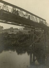
Document - Maribyrnong Valley Study Canning Street Bridge to Brimbank Park December 1990, Henshall Hansen Associates
... Maribyrnong Valley Study Canning Street Bridge to Brimbank Park December 1990...... Canning Street...Maribyrnong Valley Study Canning Street Bridge to Brimbank Park December 1990...Typed Report Maribyrnong Valley Study Canning Street Bridge to Brimbank Park December 1990 for the Western Region Commission...Maribyrnong Valley Maribyrnong River Canning Street Bridge Typed Report Maribyrnong Valley Study Canning Street Bridge to Brimbank Park December 1990 for the Western Region Commission Maribyrnong Valley Study Canning Street Bridge to Brimbank Park December 1990 Document Maribyrnong Valley Study Canning Street Bridge to Brimbank Park December 1990 Henshall Hansen Associates ...Typed Report Maribyrnong Valley Study Canning Street Bridge to Brimbank Park December 1990 for the Western Region Commissionmaribyrnong valley, maribyrnong river, canning street, bridge -
 Sunshine and District Historical Society Incorporated
Document - Maribyrnong Valley Land Use Strategy. Brimbank Park to Canning Street Bridge 1992, Maribyrnong Valley Land Use Committee February 1992, 1992
... Brimbank Park to Canning Street Bridge 1992...... Canning Street...Brimbank Park to Canning Street Bridge. Maribyrnong Valley Land use Committee February 1992....Maribyrnong Valley Maribyrnong River Canning Street Bridge Maribyrnong Valley Land Use. ...Maribyrnong Valley Land Use. Brimbank Park to Canning Street Bridge. Maribyrnong Valley Land use Committee February 1992.maribyrnong valley, maribyrnong river, canning street, bridge -
 Sunshine and District Historical Society Incorporated
Administrative record - City of Sunshine - Commissioner Mr Alexander Alex George Gillon Collection 1976 - 1982 - Report of Committee Meetings 9th December 1980, City of Sunshine, 9th December 1980
... ...Canning Street...Closure Omar Street Telephone Box Removal Darnley Street corner Burnet Avenue Purchase ICI Oval Railway Walkover Ardeer Railway Station Condition of House 5 Hillside Crescent Maribyrnong Ernie Shepherd Gardens Keeping Chickens and Birds Parking Ballarat Road and Glencairn Avenue ICI Practice Wickets Canning Street Bridge Sunshine Football Club vandalism at Skinner Reserve Southwold Street Pre-School Centre Sunshine Park Tennis Club asphalting of two courts at Parsons Reserve Footpath Radio Street Offensive Trade Maida Avenue Pedestrian Operated Signals St. ...Omar Street Maidstone Darnley Street Burnet Avenue Braybrook Ardeer Railway Station Ardeer Hillside Crescent Maribyrnong Ernie Shepherd Gardens Yardley Street Ballarat Road ICI Oval John McLeod Reserve Deer Park Canning Street Bridge Canning Street Avondale Heights Sunshine Football Club Skinner Reserve Churchill Avenue Southwold Street St. ...Closure Omar Street Telephone Box Removal Darnley Street corner Burnet Avenue Purchase ICI Oval Railway Walkover Ardeer Railway Station Condition of House 5 Hillside Crescent Maribyrnong Ernie Shepherd Gardens Keeping Chickens and Birds Parking Ballarat Road and Glencairn Avenue ICI Practice Wickets Canning Street Bridge Sunshine Football Club vandalism at Skinner Reserve Southwold Street Pre-School Centre Sunshine Park Tennis Club asphalting of two courts at Parsons Reserve Footpath Radio Street Offensive Trade Maida Avenue Pedestrian Operated Signals St. Albans Roadomar street, maidstone, darnley street, burnet avenue, braybrook, ardeer railway station, ardeer, hillside crescent, maribyrnong, ernie shepherd gardens, yardley street, ballarat road, ici oval, john mcleod reserve, deer park, canning street bridge, canning street, avondale heights, sunshine football club, skinner reserve, churchill avenue, southwold street, st. albans, sunshine park tennis club, parsons reserve, stanford street, sunshine, radio street, maida avenue, sunshine north, st. albans road -
 Sunshine and District Historical Society Incorporated
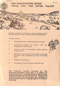
Document - The Maribyrnong River Ideas for the River Valley, City of Sunshine
... ... Canning Street...Maribyrnong Valley Maribyrnong River Canning Street Bridge Flyer The Maribyrnong River Ideas for the River Valley The Maribyrnong River Ideas for the River Valley Document The Maribyrnong River Ideas for the River Valley City of Sunshine ...Flyer The Maribyrnong River Ideas for the River Valleymaribyrnong valley, maribyrnong river, canning street, bridge -
 Sunshine and District Historical Society Incorporated
Photograph - Mr. Syd Dunn diving, 1921
... Dale, 13 Alameda Ave, Maribyrnong, March 5 1921. Near Canning Street dept of supply etc....Dale, 13 Alameda Ave, Maribyrnong, March 5 1921. Near Canning Street dept of supply etc. Photograph of Mr. ...On the back: R. C. Dale, 13 Alameda Ave, Maribyrnong, March 5 1921. Near Canning Street dept of supply etc.syd dunn, maribyrnong river, swimming -
 Sunshine and District Historical Society Incorporated
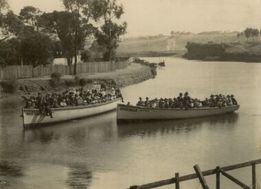
Photograph - Two boat loads of supporters for Syd Dunn on the Maribyrnong River, 1921
... Photograph of two boatloads of supporters from Maribyrnong Swimming Club cheering for Syd Dunn on his successful attempt to swim the salt water river 122 miles from the Solomons Ford 5th March 1921 Presumably donated by Dale Family On back R C Dale 13 Alameda Ave Maribyrnong near Dept of Supply and Canning Street...Syd Dunn Maribyrnong River Swimming Photograph of two boatloads of supporters from Maribyrnong Swimming Club cheering for Syd Dunn on his successful attempt to swim the salt water river 122 miles from the Solomons Ford 5th March 1921 Presumably donated by Dale Family On back R C Dale 13 Alameda Ave Maribyrnong near Dept of Supply and Canning Street Two boat loads of supporters for Syd Dunn on the Maribyrnong River Photograph Two boat loads of supporters for Syd Dunn on the Maribyrnong River ...Photograph of two boatloads of supporters from Maribyrnong Swimming Club cheering for Syd Dunn on his successful attempt to swim the salt water river 122 miles from the Solomons Ford 5th March 1921 Presumably donated by Dale Family On back R C Dale 13 Alameda Ave Maribyrnong near Dept of Supply and Canning Streetsyd dunn, maribyrnong river, swimming -
 Port of Echuca
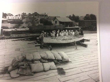
Two black and white photographs, 20/09/1984
... Shackell's Bond Store can be seen in the background. Echuca Hotel in High Street can also be seen in the distance. ...Shackell's Bond Store can be seen in the middle background, and Echcua Hotel, in High Street can be seen in the distance....Shackell's Bond Store can be seen in the background. Echuca Hotel in High Street can also be seen in the distance. ...The photograph is one of a series of photographs taken by Mike Rosel. Photographs P000027, P000028.2, P000029.3, P000030.2, P000031, P000032 are all held by Mike Rosel. This photograph shows Helen Coulson, the first Manager of the Port of Echuca, dressed in period costume, conducting a guided tour for a group of tourists, in the early 1980's. In the background another tour group is being guided through the Echuca Wharf Railway station. Shackell's Bond Store can be seen in the background. Echuca Hotel in High Street can also be seen in the distance. In the foreground there is a pile of sand bags.These photographs are significant because it shows Helen Coulson as a tour guide. It also shows that High Street could be seen from the wharf in the 1980's. These photographs also show the state of the wharf then.2 black and white photographs exactly the same,of tourists standing around a row boat which is sitting on top of the Echuca wharf. The tourists are listening to Helen Coulson, who is dressed in period costume. In the foreground is a pile of sand bags. More tourists can be seen in the background involved in a tour of the Echcua Wharf railway station. Shackell's Bond Store can be seen in the middle background, and Echcua Hotel, in High Street can be seen in the distance.There are no inscriptions or markings.helen coulson, shackell's bond store, echuca hotel, tourism, rosel, mike, echuca wharf -
 Linton and District Historical Society Inc
Photograph, Linton landscape - view from the school, looking to south-east
... Undated black and white photograph, which mostly shows buildings in Sussex Street, Linton, near the corner of Sussex and Clyde Streets. Surrey Street can be seen in the foreground but there are no houses along it....Undated black and white photograph, which mostly shows buildings in Sussex Street, Linton, near the corner of Sussex and Clyde Streets. Surrey Street can be seen in the foreground but there are no houses along it. ...Undated black and white photograph, which mostly shows buildings in Sussex Street, Linton, near the corner of Sussex and Clyde Streets. Surrey Street can be seen in the foreground but there are no houses along it."View of Linton from school. Large tree gum planted was in front of cottage dad built when they were first married. Now half covered with ivy". "(16)".sussex street linton, surrey street linton -
 Box Hill Historical Society
Photograph - Tennis Courts
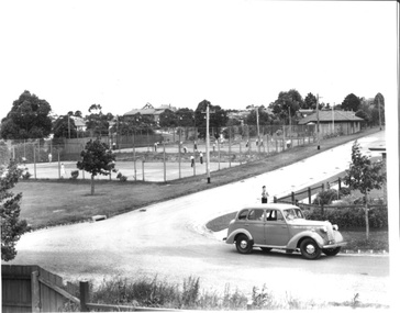
... Box Hill Primary School in Station Street can be seen in background...Box Hill Primary School in Station Street can be seen in background Irving Avenue Box Hill Primary School Tennis courts Sport Motor Vehicles B&w photo Photograph Tennis Courts ...Tennis courts in Irving Avenue, Box Hill. Box Hill Primary School in Station Street can be seen in backgroundB&w photoirving avenue, box hill primary school, tennis courts, sport, motor vehicles -
 Hume City Civic Collection
Photograph, c 1980s
... A coloured photograph of Sunbury Township looking west from above Jacksons Creek and Goonawarra Winery. Macedon Street can be seen in the middle distance and Mt. ...Hume City Civic Collection 44 Macedon Street Sunbury melbourne The photograph although recently taken shows the original settled area in Sunbury, which included Goonawarra Vineyard and Macedon Street which was once the business centre of Sunbury township before the railway was established. sunbury township mt. holden burke hill francis james goodall barnier john jacksons creek goonawarra winery george evans collection A coloured photograph of Sunbury Township looking west from above Jacksons Creek and Goonawarra Winery. Macedon Street can be seen in the middle distance and Mt. ...The photograph although recently taken shows the original settled area in Sunbury, which included Goonawarra Vineyard and Macedon Street which was once the business centre of Sunbury township before the railway was established.A coloured photograph of Sunbury Township looking west from above Jacksons Creek and Goonawarra Winery. Macedon Street can be seen in the middle distance and Mt. Holden and Burke Hill are across the skyline.sunbury township, mt. holden, burke hill, francis, james goodall, barnier, john, jacksons creek, goonawarra winery, george evans collection -
 Kew Historical Society Inc
Photograph - Construction of the Eastern Freeway (F19), Ron Setford, November 1971
... In the distance, the ESSO Service Station at the bottom Princess Street can be seen...In the distance, the ESSO Service Station at the bottom Princess Street can be seen Photograph Construction of the Eastern Freeway (F19) Ron Setford ...Ron Setford and his wife Grace Setford lived in Tanner Avenue, East Kew, from c.1946 to c.1995. A keen photographer, he recorded the changing face of Kew over a 20 year period. Apart from 30 photographs of built structures and places in Kew dating from 1960 and 1961, 145 of his 35mm colour slides chronicle the development of the F19 (later renamed Eastern) Freeway through the Yarra Valley in Kew over a five year period from c.1972 to c.1977. This important collection was donated to the Society by his granddaughter in 2025.This collection of 175 35mm slides is of local and statewide significance, owing to its subject matter, particularly the major development of road transport infrastructure during the 1970s with the construction of the Eastern Freeway. The photographer also took care to annotate and date most of his slides which enable the researcher to pinpoint temporal and spatial locations.Earth moving vehicle at the beginning of construction of the Eastern (F19) Freeway in 1971 with a temporary concrete bridge near Chandler Highway. In the distance, the ESSO Service Station at the bottom Princess Street can be seen"Eastern Freeway / Temporary Bge / Chandler Hwy / Nov 71"ron setford, eastern freeway, f19 freeway -
 Tatura Irrigation & Wartime Camps Museum
Photograph, Aerial of Tatura 1930, 1930
... Main buildings and street can be seen. Copied by W. Purcell. Original held by donor A. ...Main buildings and street can be seen. Copied by W. Purcell. Original held by donor A. ...Early aerial photograph of township of Tatura. Main buildings and street can be seen. Copied by W. Purcell. Original held by donor A. Hampton.Black and white photograph taken from a small plane of township of Taturaon back: aerial photo of Tatura 1930. -
 Whitehorse Historical Society Inc.
Photograph, Looking east to Mitcham, c1952
... Christ Church Mitcham in Edward Street can be seen on the left....Christ Church Mitcham in Edward Street can be seen on the left. Looking east to Mitcham Photograph Photograph ...Sent to a parishioner at Christ Church, Mitcham, by Phyllis Grant who lived at the Migrant Hostel in Mitcham in 1952 -54, where her husband did development work under the P.M.G.Black and white photograph of Mitcham looking east from opposite Albert Street. Note the two lane road with trees each side of the road. Christ Church Mitcham in Edward Street can be seen on the left.whitehorse road, mitcham, christ church anglican church mitcham, grant, phyllis -
 City of Ballarat Libraries
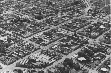
Photograph, Aerial View of the Ballarat CBD in 1957 / 1958
... This aerial view of the Ballarat CBC was taken sometime in 1957 or 1958. Sturt Street can be seen running from the right centre to top left....City of Ballarat Libraries Eureka Centre Eureka Street Ballarat East goldfields This aerial view of the Ballarat CBC was taken sometime in 1957 or 1958. Sturt Street can be seen running from the right centre to top left. ...This aerial view of the Ballarat CBC was taken sometime in 1957 or 1958. Sturt Street can be seen running from the right centre to top left.aerial view, sturt street, ballarat, central business district, cbd -
 Surrey Hills Historical Society Collection
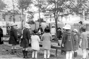
Photograph, Holy Trinity kindergarten group, 1924, 1924
... The house behind the church in Montrose Street can be seen....The house behind the church in Montrose Street can be seen. Holy Trinity kindergarten group, 1924 Photograph Norman Carter ...Norman Carter took many photos of Surrey Hills and Mont Albert from the 1920s; many were associated with events and activities of the Church of England.Black and white photo showing a group of 16 children, mostly girls, and a teacher standing in a circle around a number of benches in the rear of Holy Trinity's land. All are wearing hats. The house behind the church in Montrose Street can be seen.On the back in ink: "Kindergarten outdoors / Leader:- Miss P. Cornell / 18th. May 1924"churches, holy trinity church, anglican church, kindergartens, miss patsy cornell, montrose street, children -
 Box Hill Historical Society
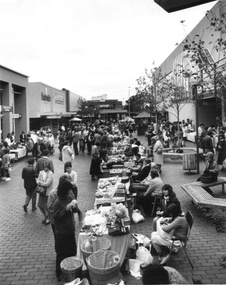
Photograph - Markets
... Crafts Market in Box Hill Hall, looking east towards Bank Street. McEwans can be seen on the right....Crafts Market in Box Hill Hall, looking east towards Bank Street. McEwans can be seen on the right. Box Hill Mall Street stalls Craft markets Shops McEwans B&w photo Photograph Markets ...Crafts Market in Box Hill Hall, looking east towards Bank Street. McEwans can be seen on the right.B&w photobox hill mall, street stalls, craft markets, shops, mcewans -
 Rutherglen Historical Society
Image, 18/05/1892
... Black and white postcard photograph of Rutherglen Main Street looking West. on the south side of the street can be seen the bank at the corner of Main and High Streets, James Tye's fruit and vegetable shop, the Rutherglen Hotel, and the Cumberland Hotel further down the street....can see by the front of this card - Things have been pretty quiet since you have been away! I know that you are on the improve now - and have been walking - so that is great news. Keep up the good work. Haven't sold a bird - yet - have sold a tea towel though. All are missing you at the 'Paris End' of Main Street...Black and white postcard photograph of Rutherglen Main Street looking West. on the south side of the street can be seen the bank at the corner of Main and High Streets, James Tye's fruit and vegetable shop, the Rutherglen Hotel, and the Cumberland Hotel further down the street. ...Identity of 'Jack' and 'Judy' unknown.Black and white postcard photograph of Rutherglen Main Street looking West. on the south side of the street can be seen the bank at the corner of Main and High Streets, James Tye's fruit and vegetable shop, the Rutherglen Hotel, and the Cumberland Hotel further down the street.Message written on back: "Rutherglen 18/5/92 / Dear Jack, As you can see by the front of this card - Things have been pretty quiet since you have been away! I know that you are on the improve now - and have been walking - so that is great news. Keep up the good work. Haven't sold a bird - yet - have sold a tea towel though. All are missing you at the 'Paris End' of Main Street - so home soon I hope. / Best wishes. Judy."main street, rutherglen hotel, james tye fruiterer -
 Federation University Historical Collection
Photograph, Site of Sovereign Hill and Ballarat Lodge
... The start of Magpie Street can be seen on the left hand side of the photograph....The start of Magpie Street can be seen on the left hand side of the photograph. ...The Old Ballarat Travel Inn was located at 613 Main Road. It later Became Ballarat Lodge and Mecure Ballarat.Photograph showing the site of Sovereign Hill in fron to the pine trees, and Elsmore street running along the right. Ballarat Lodge, the brainchild of John Gilbert, can be seen in front of the dam in the centre. The start of Magpie Street can be seen on the left hand side of the photograph.ballarat lodge, john gilbert, sovereign hill, elsmore street, main road, ballarat east, old ballarat travel inn -
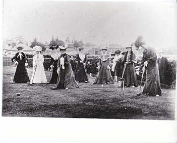 Canterbury History Group
Photograph - Ladies playing croquet, c1890s
... Logan and Cross streets can be seen in the background. The house behind the lady fourth from the right is still standing {2008} ...Logan and Cross streets can be seen in the background. The house behind the lady fourth from the right is still standing {2008} Canterbury Kendall Street Cross Street Logan Street Canterbury Bowling Club Croquet back and white photograph Photograph Ladies playing croquet ...Ladies playing croquet, probably on the site of the old Canterbury Bowling Club in Kendall Street. Logan and Cross streets can be seen in the background. The house behind the lady fourth from the right is still standing {2008} back and white photographcanterbury, kendall street, cross street, logan street, canterbury bowling club, croquet -
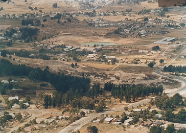
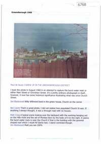 Greensborough Historical Society
Article and Photograph, Greensborough 1968, 2016_
... Photograph courtesy of Paul de Sauty, taken from Hailes Street. Church Street can be seen in this photo, prior to building of Greensborough Plaza....Photograph courtesy of Paul de Sauty, taken from Hailes Street. Church Street can be seen in this photo, prior to building of Greensborough Plaza. ...Information and photo of a burst water main in either Grimshaw or Main Street Greensborough. Photograph courtesy of Paul de Sauty, taken from Hailes Street. Church Street can be seen in this photo, prior to building of Greensborough Plaza.This photograph and text was copied from a Facebook site. Members are people who lived in the Greensborough area and share their reminiscences of the area with others. The site is administered by a GHS member but is not officially affiliated with the Society. Any information is the opinion of the contributor. Article and photograph sourced from social media.greensborough, church street greensborough -
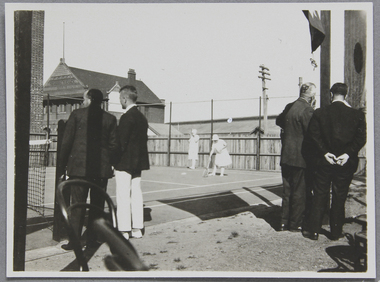 Mission to Seafarers Victoria
Photograph - Photograph, Black and white, Tennis court opening, 18 September 1926
... In the background the former Seamen's Institute, Siddeley Street, can be seen as well as the docks on Australian Wharf....In the background the former Seamen's Institute, Siddeley Street, can be seen as well as the docks on Australian Wharf. ...The picture was possibly taken for the opening of the tennis court Saturday 18 September 1926. Lady Creswell was invited to officially open the court and about a 100 persons attended the ceremony.Photograph taken in 1926 on the tennis court of the Mission to Seafarers, 717 Flinders Street. First plan are unidentified men turning their back to the photographer. On the court are two ladies wearing white tennis attire are playing double. In the background the former Seamen's Institute, Siddeley Street, can be seen as well as the docks on Australian Wharf.tennis, mission to seafarers victoria, tennis court, lady creswell, reverend john reginald weller, 1926, lady adelaide elizabeth creswell nee stow, 1859-1945, william rooke creswell (1852-1933), mission to seamen, weller album -
 Rutherglen Historical Society
Image, 1900 Approximate
... In centre of photograph, right at the end of the street can be seen, faintly, the building called Seppelts Cellars (later Jolimont Winery, Now (2017) Tuileries). ...In centre of photograph, right at the end of the street can be seen, faintly, the building called Seppelts Cellars (later Jolimont Winery, Now (2017) Tuileries). ...Donated by Mr Greg Thomson, a former resident of RutherglenBlack & white photographic reproduction, unframed, laminated. This photograph is of Main St Rutherglen facing West. In centre of photograph, right at the end of the street can be seen, faintly, the building called Seppelts Cellars (later Jolimont Winery, Now (2017) Tuileries). Building on right had side with "saddler" painted on it, is the building that became the Rutherglen Sun officeOn back of photo: "Main St Rutherglen - facing west"main street, seppelts winery, jolimont winery, tuileries -
 Stawell Historical Society Inc
Photograph, The Pleasant Creek Cross Reef No1 Shaft Panorama of a Mining Scene in the Duke Sands area c1875
... St Peters Lutheran Church in Scallan Street can be seen on the right horizon. ...St Peters Lutheran Church in Scallan Street can be seen on the right horizon. stawell mining Two mines and workings on other side of Moonies settling dam. ...Mining Scene Duke Sands area c1875 Behind the tree on left is Extended Cross Mine and on the right is the Oriental Mine. In the centre is the North Cross Mine No1 shaft. In the foreground is one of the Moonlight dams. St Peters Lutheran Church in Scallan Street can be seen on the right horizon. Two mines and workings on other side of Moonies settling dam. Two Gentlemen lower left cornerstawell mining -
 Surrey Hills Historical Society Collection
Photograph - Digital photograph, George L Coop, Whitehorse Road Mont Albert during road widening, 1958, c1958
... The house on the corner of High Street and Whitehorse Road (39 High Street) can be seen in the middle distance. ...The house on the corner of High Street and Whitehorse Road (39 High Street) can be seen in the middle distance. george l coop whitehorse road box hill gas works mont albert 39 high street road works A digital copy of a colour photograph of Whitehorse Road, Mont Albert looking towards Box Hill. ...The donor George Lister Coop was about 21 years of age when he took this photo in 1958 as Whitehorse Road was being widened. This was done in sections. It was taken from adjacent to the Coop family home at No.688. The house on the corner of High Street and Whitehorse Road (39 High Street) can be seen in the middle distance. A digital copy of a colour photograph of Whitehorse Road, Mont Albert looking towards Box Hill. The chimneys of Box Hill Gasworks can be seen in the distance. It was taken from adjacent to No 688.george l coop, whitehorse road, box hill gas works, mont albert, 39 high street, road works -
 Melbourne Tram Museum
Photograph - Two colour slides - St Kilda Road Trackworks, 1-8-1970
... The former tracks into City Road and Sturt Street can be seen in the foreground. .2 - SW6 878 - shows the Arts Centre, YMCA building the intersection with City Road and Sturt Street ...The former tracks into City Road and Sturt Street can be seen in the foreground. .2 - SW6 878 - shows the Arts Centre, YMCA building the intersection with City Road and Sturt Street Photograph Two colour slides - St Kilda Road Trackworks ...Set of two colour slides showing the intersection of St Kilda Road, City Road and Sturt Street. City Road at the start of work to lower City Road under St Kilda Road. The tracks along Sturt Street had been diverted by Nolan Street (now Southbank Blvd). The photo shows that only one of the tracks had been brought into use, the other still under construction. Photography by Warren Doubleday.Yields information on the start of the works to lower City Road under St Kilda Road 1-8-1970Set of two Anscochrome colour slides, of trackwork to place City Road under St Kilda Road. .1 - SW6 959 on St.-Kilda Road deviation - shows the Arts Centre and the scale of the deviation. The former tracks into City Road and Sturt Street can be seen in the foreground. .2 - SW6 878 - shows the Arts Centre, YMCA building the intersection with City Road and Sturt Street Has photographers slide numbers on each slide.trackworks, sturt st, sw6 class, tram 959, tram 878, tramways, track, city road, st kilda road, trams -
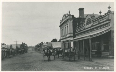 Kilmore Historical Society
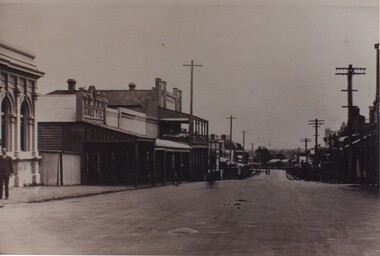
Photograph, Sydney Street Looking South, 1912
... 12.5cm x 20cm black and white photograph looking south on Sydney Street. Can be seen is original building which are now demolished. ...Sydney Str. looking south 1912 Kilmore Historical Society 12.5cm x 20cm black and white photograph looking south on Sydney Street. Can be seen is original building which are now demolished. ...12.5cm x 20cm black and white photograph looking south on Sydney Street. Can be seen is original building which are now demolished. Also can be seen is: Morrissey Butchers, J.Loft Railway Hotel, Bullivant, some unidentified building and the Red Lion Hotel. Also in the picture are horse drawn vehicles and people walking on the footpaths, and power poles. One copy of the image is mounted on archival board.Written on the back of the mounting: 104/1.22 20486/1-22 Looking South Sydney St Kilmore Shops now demolished on left From right Morrissey Butchers, J. Loft Railway Hotel, Bullivant ?, ?, ?, Red Lion Hotel. R.J. Fagg. 17 Link Avenue, Kilmore 3601 Written on the back of one copy: 104/1.22 22 200486/1 22 P.C. Sydney Str. looking south 1912 Kilmore Historical Societyshopfronts, storefronts, retail stores -
 Surrey Hills Historical Society Collection
Photograph, Union Road looking west from the steeple of Holy Trinity Church, 1922, 1922
... In the foreground immature street trees can be seen and an original telephone pole with white insulators. ...In the foreground immature street trees can be seen and an original telephone pole with white insulators. ...At the edge of the church roof and on the horizon is 'The Knoll' on the corner of Union Road and Wandsworth Road. To the left of this is 297 Mont Albert Road, home of the Michael Parer family and further left is "Quamby", home of the Sherar family. This is easily recognised by the square viewing tower located on the west wing of the house. The Sherar family owned 'Quamby' from 1900 until 1925, when it became Mosgiel Private Hospital. Norman Carter took many photos of Surrey Hills and Mont Albert in the 1920s; many associated with events and activities of the Church of England. Black and white photo of taken from the steeple of Holy Trinity Church, during its construction, across Union Road to the north-west. In the foreground immature street trees can be seen and an original telephone pole with white insulators. The street has formed paths and bluestone kerb and channelling. holy trinity anglican church, union road, the knoll, quamby, street trees, telegraph and light poles, mosgiel hospital -
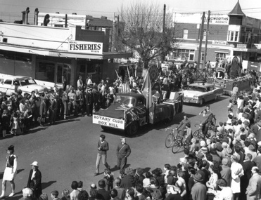 Box Hill Historical Society
Photograph - Street Parade, c1950s
... The Box Hill Fisheries business on the corner of Bank Street and Station Street can be seen to the left of the photo, and Ellingsworth's Estate Agency can be seen on the right of the photograph, on the corner of Rutland Road and Station Street....The Box Hill Fisheries business on the corner of Bank Street and Station Street can be seen to the left of the photo, and Ellingsworth's Estate Agency can be seen on the right of the photograph, on the corner of Rutland Road and Station Street. ...Street Parade of floats travelling north along Station Street, Box Hill. This view shows the Rotary Club of Box Hill and Lions Club entries in the Street Parade as they cross over the Railway line. The Box Hill Fisheries business on the corner of Bank Street and Station Street can be seen to the left of the photo, and Ellingsworth's Estate Agency can be seen on the right of the photograph, on the corner of Rutland Road and Station Street.B&w photofestivals and celebrations, clothing and dress, station street, rotary club of box hill, lions clubs, railway crossings, box hill fisheries, ellingsworth estate agency, bank street, rutland road -
 Eltham District Historical Society Inc
Photograph, Russell Yeoman, Looking south from Swan Street, Eltham, c,1965, 1965c
... Presnt day SES building at corner of Susan and Bridge Street can be seen in centre background.The factory in lower left on Brisbane Street is the Sibbel Builders factory of Martin and Herman Sibbel who were ahead of their time with design and prefabricated frames and also built cabinetry in this factory....Presnt day SES building at corner of Susan and Bridge Street can be seen in centre background.The factory in lower left on Brisbane Street is the Sibbel Builders factory of Martin and Herman Sibbel who were ahead of their time with design and prefabricated frames and also built cabinetry in this factory. eltham streets susan street bridge street brisbane street train bunnings ses state emergency service Sibbel Builders Martin Sibbel Herman Sibbel Digital file only; created from original colour positive slide transparency Looking south from Swan Street, Eltham, c,1965 Photograph Russell Yeoman ...Train in foreground, Bridge street running parallel to train in background and Brisbane Street obscured by train. Susan Street north of Bridge Street (now Brisbane Street) on left. Vacant block of land is now the site of Bunnings. Presnt day SES building at corner of Susan and Bridge Street can be seen in centre background.The factory in lower left on Brisbane Street is the Sibbel Builders factory of Martin and Herman Sibbel who were ahead of their time with design and prefabricated frames and also built cabinetry in this factory.Digital file only; created from original colour positive slide transparencyeltham, streets, susan street, bridge street, brisbane street, train, bunnings, ses, state emergency service, sibbel builders, martin sibbel, herman sibbel -
 Port of Echuca
Photograph, Approx. 1970's
... In the right back corner of the photograph, the 'lantern' roof of the St George's Hall can be seen. The street is level with the front entrance to the Hotel, which is very different to what it is today....In the right back corner of the photograph, the 'lantern' roof of the St George's Hall can be seen. The street is level with the front entrance to the Hotel, which is very different to what it is today. ...The Bridge Hotel was built by Henry Hopwood to house visitors to the town crossing the Murray River on his punt , which was situated just below the Bridge Hotel on the Murray River. The accommodation was spacious and grand! In the right back corner of the photograph, the 'lantern' roof of the St George's Hall can be seen. The street is level with the front entrance to the Hotel, which is very different to what it is today.The photograph shows hotel activities and accommodation in the late 19th Century. The Bridge Hotel was a very busy place as can be seen with women on the balcony, a stage coach full of people, laden carts and buggies.The Bridge Hotel Echuca - photo taken looking south towards front of building. Four people can be seen on the balcony and several gathered under the verandah. In the foreground are several horse-drawn carriages. The road in front of the hotel is unmade and very wide, with the roof of St.George's Hall seen over the right (western) wing of the hotel. Verso: Bridge Hotel, 1860s? St. George's Hall in background.bridge hotel, henry hopwood, lantern roof, st.george's hall, 1870s