
Showing 125 items matching " caulfield’s building heritage"
-
 City of Moorabbin Historical Society (Operating the Box Cottage Museum)
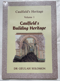
Book, Solomon, Geulah, Caulfield's Building Heritage : Caulfield's Heritage : Volume 1, 1989
... Caulfield's Building Heritage : Caulfield's Heritage : Volume 1...Caulfield buildings Heritage buildings ill., maps, ports. ; Vols. 1-4 together in case. ...ill., maps, ports. ; Vols. 1-4 together in case. Includes bibliographies and indexes.non-fictioncaulfield, buildings, heritage buildings -
 Glen Eira Historical Society
Letter - Westfield, Corner Eskdale and Wyuna Roads, Caulfield North
... Caulfield Historical Society... Caulfield’s Building Heritage...Caulfield Historical Society Caulfield’s Building Heritage Eskdale Road Kambrook Road Wyuna Road Stevens George Pescott David James Pescott James Richard Pescott Keith Woodfull Heathcote Norman Westfield Wyuna Road Woodfull Cecily Woodfull Dorothy Heathcote Norman Mrs. ...Letter from George Stevens to Caulfield Historical Society dated 27/08/2001 regarding the owners of Westfield 1904 to 1952 plus a brief history of the property and the reason for the house name. Photocopy of two photographs plus handwritten notes on the value, owners and builder of Westfield.caulfield historical society, caulfield’s building heritage, eskdale road, kambrook road, wyuna road, stevens george, pescott david james, pescott james richard, pescott keith woodfull, heathcote norman, westfield, wyuna road, woodfull cecily, woodfull dorothy, heathcote norman mrs., heathcote norma, oakley norma, house names, solomon g. dr., dunbar margaret, leonard f., leonard s., timber houses, land values, heathcote dorothy -
 Glen Eira City Council History and Heritage Collection
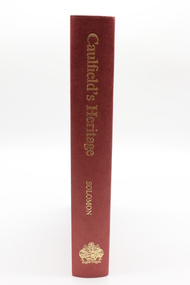
Book, "Caulfield's Heritage"
... Caulfield's Heritage" by Dr Geulah Solomon. Red hardcover book with gold embossed lettering down spine which reads 'Caulfield's Heritage Solomon' and post-1975 City of Caulfield Ensign. Housed in hardcover red sleeve. Includes Volume 1: Caulfield's Building...Caulfield's Heritage" by Dr Geulah Solomon. Red hardcover book with gold embossed lettering down spine which reads 'Caulfield's Heritage Solomon' and post-1975 City of Caulfield Ensign. Housed in hardcover red sleeve. Includes Volume 1: Caulfield's Building ...This book was written by Dr. Geulah Solomon.Single publication combining Volumes 1-4 of "Caulfield's Heritage" by Dr Geulah Solomon. Red hardcover book with gold embossed lettering down spine which reads 'Caulfield's Heritage Solomon' and post-1975 City of Caulfield Ensign. Housed in hardcover red sleeve. Includes Volume 1: Caulfield's Building Heritage, Volume 2: Caulfield's Cultural Heritage, Volume 3: Caulfield's Recreational Heritage, Volume 4: Caufield's Recent Municipal Heritage. -
Glen Eira Historical Society
Letter - Beauville Estate
... She corrects a small error on page 8 of Caulfield’s Building Heritage Volume 1 where Beauville Estate has been mistakenly referred to as Beaufort Estate. ...She corrects a small error on page 8 of Caulfield’s Building Heritage Volume 1 where Beauville Estate has been mistakenly referred to as Beaufort Estate. ...Letter dated 08/10/2001 from Sarah Burgess, Communications Manager at A V Jennings Homes to Glen Eira Historical Society. She corrects a small error on page 8 of Caulfield’s Building Heritage Volume 1 where Beauville Estate has been mistakenly referred to as Beaufort Estate. The file also includes a photocopy of the relevant page with the error highlighted.a v jennings, a v jennings homes, burgess sarah, heritage, beauville estate, beaufort estate, caulfield, builders, residential development, carnegie, heritage, a v jennings library, murrumbeena, glenhuntly, glen huntly -
Glen Eira Historical Society
Letter - Bellecourt, Seymour Road, 85, Elsternwick
... Also included is a document giving additional details on Bellecourt with a black and white illustration (85mm x 130mm) of the house, source unknown though handwritten notes provide that it is a duplicate from the book Caulfield’s Building Heritage...Also included is a document giving additional details on Bellecourt with a black and white illustration (85mm x 130mm) of the house, source unknown though handwritten notes provide that it is a duplicate from the book Caulfield’s Building Heritage Bellecourt Buildings Heritage studies Architectural features History Johnston Mr Hart Trevor Town clerks Caulfield South Filbert Street Beemery Glen Eira Road Kooyong Road Seymour Road Blanche Street Kooyong Estate Caulfield Caulfield North Langdon Charles Pettey Rosecraddock Rose Craddock Tarqua Hengar Victorian style Seymour Street Kooyong Estate Beemery Park Extension Langdon H J Langdon Montague Lirrewa Rennick Samuel The Garrell Langdon family Victorian era Neringa Little Gromer Little Cromer Parson Charles Moloney James Trezise Alex Vassy Albert Johnston Mrs Solomon G Caulfield’s Heritage Volume 1 City of Caulfield City of Glen Eira Heritage Management Plan Ward Andrew Belemery Park Johnston Archibald Letter Bellecourt, Seymour Road, 85, Elsternwick ...A typewritten letter to Mr Johnston from the National Trust Victoria, concerning the listing of Bellecourt by the Trust. The file also includes a print of the Victorian Heritage Database web page on Bellecourt with a black and white photograph (60mm x 45mm) of the house. Also included is a document giving additional details on Bellecourt with a black and white illustration (85mm x 130mm) of the house, source unknown though handwritten notes provide that it is a duplicate from the book Caulfield’s Building Heritagebellecourt, buildings, heritage studies, architectural features, history, johnston mr, hart trevor, town clerks, caulfield south, filbert street, beemery, glen eira road, kooyong road, seymour road, blanche street, kooyong estate, caulfield, caulfield north, langdon charles pettey, rosecraddock, rose craddock, tarqua, hengar, victorian style, seymour street, kooyong estate, beemery park extension, langdon h j, langdon montague, lirrewa, rennick samuel, the garrell, langdon family, victorian era, neringa, little gromer, little cromer, parson charles, moloney james, trezise alex, vassy albert, johnston mrs, solomon g, caulfield’s heritage , volume 1 city of caulfield, city of glen eira heritage management plan, ward andrew, belemery park, johnston archibald -
 Glen Eira Historical Society
Photograph - Elsternwick Club, Sandham Street, 19, Elsternwick
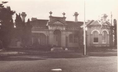
... Building at Sandham Street. 2/ Two identical postcards advertising the opening of the Tabaret at the Elsternwick Club in 1996, with four historic photographs of the club included on the front. The back advertises the opening hours, price of alcohol and gaming machines. 3/ An original colour site plan (300mm x 290mm) on tracing paper in ink of the Club’s premises, prepared by Thomas Watts and Son Architects 77 Swanston Street with a colour photocopy of this same plan. 4/ Photocopy of page 15 from the 1985 second edition of the City of Caulfield's "caulfield's building heritage" directory and information guide which provides basic information about the Elsternwick Club building and includes an illustration (115mm x 85mm) of the exterior of the Club....Building at Sandham Street. 2/ Two identical postcards advertising the opening of the Tabaret at the Elsternwick Club in 1996, with four historic photographs of the club included on the front. The back advertises the opening hours, price of alcohol and gaming machines. 3/ An original colour site plan (300mm x 290mm) on tracing paper in ink of the Club’s premises, prepared by Thomas Watts and Son Architects 77 Swanston Street with a colour photocopy of this same plan. 4/ Photocopy of page 15 from the 1985 second edition of the City of Caulfield's "caulfield's building heritage" directory and information guide which provides basic information about the Elsternwick Club building and includes an illustration (115mm x 85mm) of the exterior of the Club. ...Four items about the Elsternwick Club: 1/ An undated black and white photograph (90mm x 140mm) of the exterior of the Elsternwick Club Building at Sandham Street. 2/ Two identical postcards advertising the opening of the Tabaret at the Elsternwick Club in 1996, with four historic photographs of the club included on the front. The back advertises the opening hours, price of alcohol and gaming machines. 3/ An original colour site plan (300mm x 290mm) on tracing paper in ink of the Club’s premises, prepared by Thomas Watts and Son Architects 77 Swanston Street with a colour photocopy of this same plan. 4/ Photocopy of page 15 from the 1985 second edition of the City of Caulfield's "caulfield's building heritage" directory and information guide which provides basic information about the Elsternwick Club building and includes an illustration (115mm x 85mm) of the exterior of the Club.For item 1 inscription: Elsternwick Club Sandham Stst georges road, elsternwick, elsternwick club, thomas watts and son, sandham street, site plans -
 Glen Eira Historical Society
Album - Album page, Ercildoune (576), Inkerman Street, Circa 1972
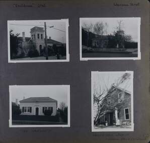
... buildings worthy of preservation. The album is related to a Survey the Caulfield Historical Society developed in collaboration with the National Trust of Australia (Victoria) and Caulfield City Council to identify historic buildings within the City of Caulfield that warranted the protection of a National Trust Classification. Principal photographer thought to be Trevor Hart, member of Caulfield Historical Society. Most photographs were taken between 1966-1972 with a small number of photographs being older and from unknown sources. All photographs are black and white except where stated, with 386 photographs over 198 pages. Vol 1 Caulfield's Building Heritage...buildings worthy of preservation. The album is related to a Survey the Caulfield Historical Society developed in collaboration with the National Trust of Australia (Victoria) and Caulfield City Council to identify historic buildings within the City of Caulfield that warranted the protection of a National Trust Classification. Principal photographer thought to be Trevor Hart, member of Caulfield Historical Society. Most photographs were taken between 1966-1972 with a small number of photographs being older and from unknown sources. All photographs are black and white except where stated, with 386 photographs over 198 pages. Vol 1 Caulfield's Building Heritage ...This photograph is part of the Caulfield Historical Album 1972. This album was created in approximately 1972 as part of a project by the Caulfield Historical Society to assist in identifying buildings worthy of preservation. The album is related to a Survey the Caulfield Historical Society developed in collaboration with the National Trust of Australia (Victoria) and Caulfield City Council to identify historic buildings within the City of Caulfield that warranted the protection of a National Trust Classification. Principal photographer thought to be Trevor Hart, member of Caulfield Historical Society. Most photographs were taken between 1966-1972 with a small number of photographs being older and from unknown sources. All photographs are black and white except where stated, with 386 photographs over 198 pages. Vol 1 Caulfield's Building Heritage by Dr Geulah Solomon states that Ercildoune was the home of Sir Samuel Wilson and later, Arthur Knox. Knox is likely the person who subdivided the land, creating Ercildoune Street.Page 100 of Photograph Album with two photographs (landscape) of Ercildoune and two photographs (one landscape and one portrait) of two other houses on Inkerman Street.Handwritten: "Ercildoune" (576) [top left] / Inkerman Street [top right] / 138 INKERMAN ST [under bottom left photo] / LABASSA GROVE CORNER OF INKERMAN OPPOSITE ERCILDOUNE [under bottom right photo] / 100 [bottom right]trevor hart, east st kilda, ercildoune, mansions, towers, gardens, bloomsbury, inkerman road, labassa grove, attic houses, porches, inkerman street, caulfield north, st kilda east, sir samuel wilson, arthur knox, ercildoune street, house names -
 Glen Eira Historical Society
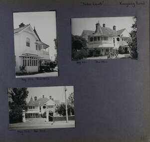
Album - Album page, Tudor Court, Kooyong Road, Dec 1972
... Caulfield City Council to identify historic buildings within the City of Caulfield that warranted the protection of a National Trust Classification. Principal photographer thought to be Trevor Hart, member of Caulfield Historical Society. Most photographs were taken between 1966-1972 with a small number of photographs being older and from unknown sources. All photographs are black and white except where stated, with 386 photographs over 198 pages. Sands & McDougalls directory of Victoria : 1970 gives address as 141 Kooyong Road, Caulfield North. "Caulfield's Building Heritage...Caulfield City Council to identify historic buildings within the City of Caulfield that warranted the protection of a National Trust Classification. Principal photographer thought to be Trevor Hart, member of Caulfield Historical Society. Most photographs were taken between 1966-1972 with a small number of photographs being older and from unknown sources. All photographs are black and white except where stated, with 386 photographs over 198 pages. Sands & McDougalls directory of Victoria : 1970 gives address as 141 Kooyong Road, Caulfield North. "Caulfield's Building Heritage ...This photograph is part of the Caulfield Historical Album 1972. This album was created in approximately 1972 as part of a project by the Caulfield Historical Society to assist in identifying buildings worthy of preservation. The album is related to a Survey the Caulfield Historical Society developed in collaboration with the National Trust of Australia (Victoria) and Caulfield City Council to identify historic buildings within the City of Caulfield that warranted the protection of a National Trust Classification. Principal photographer thought to be Trevor Hart, member of Caulfield Historical Society. Most photographs were taken between 1966-1972 with a small number of photographs being older and from unknown sources. All photographs are black and white except where stated, with 386 photographs over 198 pages. Sands & McDougalls directory of Victoria : 1970 gives address as 141 Kooyong Road, Caulfield North. "Caulfield's Building Heritage" p67 includes that this mansion was originally called Fairhaven, built for George Hope, a dairy farmer. He changed the name to Tudor Court in 1915 when he moved his dairy to Cranbourne.Page 116 of Photograph Album with three photographs (one portrait and two landscape) of different views of Tudor Court in its garden. Handwritten: "Tudor Court" Kooyong Road [top right] / Neg 252 Dec 1972 [under top left photo] / Neg 251 Dec 1972 [under top right photo] / Neg 253 Dec 1972 [under bottom left photo] / 116 [bottom right]trevor hart, caulfield north, kooyong road, mansion, verandah, tudor court, george hope, terracotta tiles, terracotta roof, arched windows, port cochere, square bay window, timber balustrade, columned balcony, receptions, fairhaven, arcare caulfield aged care, 1910's, spire, ridge capping, conical roof, verandahs, victorian architectural style, tudor style, queen anne style, lead lights windows, shingle roofs -
 Glen Eira Historical Society
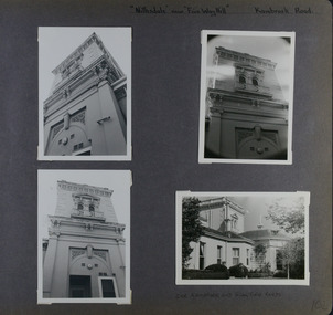
Album - Album page, Nithsdale now Five Way Hill, Kambrook Road, Circa 1972
... Crouchin 1858 and extended in 1885 with a tower and associated rooms, survives as testimony to the nineteenth century occupation of the vicinity of the Kambrook/Glen Eira Road intersection. Caulfield's Building Heritage by Dr Geulah Solomon, Vol 1 p49 records it as a small Victorian mansion home on bluestone foundations of Italianate style with a tower. ...Crouchin 1858 and extended in 1885 with a tower and associated rooms, survives as testimony to the nineteenth century occupation of the vicinity of the Kambrook/Glen Eira Road intersection. Caulfield's Building Heritage by Dr Geulah Solomon, Vol 1 p49 records it as a small Victorian mansion home on bluestone foundations of Italianate style with a tower. ...This photograph is part of the Caulfield Historical Album 1972. This album was created in approximately 1972 as part of a project by the Caulfield Historical Society to assist in identifying buildings worthy of preservation. The album is related to a Survey the Caulfield Historical Society developed in collaboration with the National Trust of Australia (Victoria) and Caulfield City Council to identify historic buildings within the City of Caulfield that warranted the protection of a National Trust Classification. Principal photographer thought to be Trevor Hart, member of Caulfield Historical Society. Most photographs were taken between 1966-1972 with a small number of photographs being older and from unknown sources. All photographs are black and white except where stated, with 386 photographs over 198 pages. Glen Eira Heritage Management Plan (1996) by Andrew Ward and Associates - Vol 3 "Nithsdale", built for J.S. Crouchin 1858 and extended in 1885 with a tower and associated rooms, survives as testimony to the nineteenth century occupation of the vicinity of the Kambrook/Glen Eira Road intersection. Caulfield's Building Heritage by Dr Geulah Solomon, Vol 1 p49 records it as a small Victorian mansion home on bluestone foundations of Italianate style with a tower. Built for J S Chambers circa 1860, it was built in stages and then the land subdivided in the 1920s. Other owners include Adolph F Brockhoff (of Brockhoff Biscuits company). Names used besides Nithsdale have been Bundoora and Five Way Hill. Page 102 of Photograph Album with four photographs (three landscape and one portrait) of Nithsdale, now known as Five Way Hill. Three views of the tower and one of the house.Handwritten: "Nithsdale" now "Five Way Hill" Kambrook road [top right] / CNR KAMBROOK AND GLENEIRA ROADS [under bottom right photo] / 102 [bottom right]trevor hart, north caulfield, victorian, mid victorian, late victorian, tower, j.s. crouchin, 1850's, 1880's, italianate, rendered, five way hill, nithsdale, slate roof, plaster arches, ornamental columns, triangular pediment, ornamental parapet, cast iron balconies, kambrook road, glen eira road, t crouch, j s crouchin, mansions, j s chambers, bluestone foundations, land subdivision, adolph f brockhoff, bundoora, house names -
Glen Eira Historical Society
Article - Rosemont, Kooyong Road, 112A, Caulfield North
... Excerpt from Caulfield’s Building Heritage p.47-48 Volume 1 by Dr. Geulah Solomon about Rosemont giving description and history (start of entry on page 46 omitted). ...Excerpt from Caulfield’s Building Heritage p.47-48 Volume 1 by Dr. Geulah Solomon about Rosemont giving description and history (start of entry on page 46 omitted). ...Eight items about this property: Handwritten notes from 1870 Caulfield rate book along with list of owners 1870-1890; unsigned and undated. Short history of Rosemont from 1860’s with owners listed up to 1895. Includes description of land and architectural features of house with sketch of pillar. Unsigned and undated with both typed and handwritten information. Unsigned and undated note (original and photocopy) about 112 Kooyong Road and Rosemont’s changing address over time. Photocopy of Andrew Ward’s Heritage Study (two pages) on 112 Kooyong Road (rear) describing significance, history and description of property. Includes photo. Online print without photo of same Heritage Study with handwritten note about brick exterior provided by owner/occupier to compiler Andrew Frederick 2010. Excerpt from Caulfield’s Building Heritage p.47-48 Volume 1 by Dr. Geulah Solomon about Rosemont giving description and history (start of entry on page 46 omitted). Added by Claire Barton date unknown. Notes taken by Andrew Frederick from Caulfield Heritage Vol.1 pages 47-9 re history; and from Sands and McDougall Directories of 1874, 1903, 1911, 1913 and 1923; plus 1913 entry in Vict. P.O Directory. These show house numbers and owners for those periods. Three pages of plans relating to Rosemont covering ground and first floors.rosemont, caulfield north, howitt godfrey dr., kooyong road, blake arthur, grice james, cast iron work, cellars, campbell john a., campbell john archibald, stables, verandahs, king thomas, howitt’s corner, howitt alfred william, farm houses, bakewell john, architectural features, bricks, mcwilliams robert, rosemont estate, mansions, howitt william godfrey dr., arches, balaclava road, coach houses, outbuildings, timber houses, squatters, campbell john, connelly mrs., king florence, slate tiles, ward andrew, chimneys, fireplaces, allen george, warburton james, mirfield professor, hall william sir, hall lady, land subdivision, cellars, embossed leather features, bay windows, house names, victorian style, ceilings, stairs, gardens -
Glen Eira Historical Society
Article - Glen Eira
... Six items about the Glen Eira Mansion: 1/Letter dated 2/06/2012 from the St Kilda Historical Society to Glen Eira Historical Society asking for further information as well as providing some items on Glen Eira’s history 2/ Attachment to above letter of information about Glen Eira printed from Melbourne Mansions Database on 30/05/2012 about Glen Eira House referencing the Argus newspaper for 10/03/1865 and 25/07/1881, ‘Sand, Swamp and Heath’, ‘Caulfield’s Building Heritage and Pioneer Families’. Entry is dated 27/06/1997. 3/ Second attachment to above letter of a memo detailing information about Glen Eira mansion form History and Heritage Officer at City of Glen Eira together with an image extract of birth notices from the Argus 22/5/1863 re the birth of a daughter to W.Lamborn Esq on 20/05/1863 at Glenalry house Caulfield 4/ Third attachment to above letter of questions and parish plan image re properties including area occupied by Glen Eira from Heritage Officer St Kilda Historical Society 5/ Southern Scenarion quarterly newsletter of the Royal Southern Memorial Hospital Issue No. 7 Winter 1988. ...Six items about the Glen Eira Mansion: 1/Letter dated 2/06/2012 from the St Kilda Historical Society to Glen Eira Historical Society asking for further information as well as providing some items on Glen Eira’s history 2/ Attachment to above letter of information about Glen Eira printed from Melbourne Mansions Database on 30/05/2012 about Glen Eira House referencing the Argus newspaper for 10/03/1865 and 25/07/1881, ‘Sand, Swamp and Heath’, ‘Caulfield’s Building Heritage and Pioneer Families’. Entry is dated 27/06/1997. 3/ Second attachment to above letter of a memo detailing information about Glen Eira mansion form History and Heritage Officer at City of Glen Eira together with an image extract of birth notices from the Argus 22/5/1863 re the birth of a daughter to W.Lamborn Esq on 20/05/1863 at Glenalry house Caulfield 4/ Third attachment to above letter of questions and parish plan image re properties including area occupied by Glen Eira from Heritage Officer St Kilda Historical Society 5/ Southern Scenarion quarterly newsletter of the Royal Southern Memorial Hospital Issue No. 7 Winter 1988. ...Six items about the Glen Eira Mansion: 1/Letter dated 2/06/2012 from the St Kilda Historical Society to Glen Eira Historical Society asking for further information as well as providing some items on Glen Eira’s history 2/ Attachment to above letter of information about Glen Eira printed from Melbourne Mansions Database on 30/05/2012 about Glen Eira House referencing the Argus newspaper for 10/03/1865 and 25/07/1881, ‘Sand, Swamp and Heath’, ‘Caulfield’s Building Heritage and Pioneer Families’. Entry is dated 27/06/1997. 3/ Second attachment to above letter of a memo detailing information about Glen Eira mansion form History and Heritage Officer at City of Glen Eira together with an image extract of birth notices from the Argus 22/5/1863 re the birth of a daughter to W.Lamborn Esq on 20/05/1863 at Glenalry house Caulfield 4/ Third attachment to above letter of questions and parish plan image re properties including area occupied by Glen Eira from Heritage Officer St Kilda Historical Society 5/ Southern Scenarion quarterly newsletter of the Royal Southern Memorial Hospital Issue No. 7 Winter 1988. It contains a black and white photograph of Glen Eira with a brief history of the residence and owner on p2 plus an article on p3 about the bequest from the late Rudolph Ashley Ricketson for the Ashley Ricketson Centre in the hospital. Demolition of the mansion occurred in 1965. 6/ Newspaper article (source & date unknown) about the bequest from Ashley Ricketson of $10.5 million to the Southern Memorial Hospital in Caulfield. It is on the site of Glen Eira, demolished 4 years prior. A sketch and photo of the hospital.glen eira, glen eira house, ricketson henry, lamborn william, kooyong road, caulfield, alison road, seymour road, beemery park, elsternwick, watts thomas, mansions, sargood frederick, rippon lea, australian general military hospital no. 11, southern memorial hospital, architects, staniforth georgina, were edith alice mary, were jonathon binns, fulton thomas, caulfield district crown land, glen huntly road, glen eira road, hawthorn road, military hospitals, ricketson rudolph ashley, towers, jacka albert captain vc, the white house, soldiers, hospitals, caulfield geriatric hospital, glenalry, caulfield roads board, foot henry boorn, surveyors, southern scenario, ashley ricketson centre, royal southern memorial hospital, best joan mrs, caulfield grammar school, the white house, barrata, house names -
 City of Moorabbin Historical Society (Operating the Box Cottage Museum)
Book, Solomon, Geulah, Caulfield's Cultural Heritage : Caulfield's Heritage :Volume 2, 1989
... Caulfield buildings Heritage buildings ill., maps, ports. ; Vols. 1-4 together in case. ...ill., maps, ports. ; Vols. 1-4 together in case. Includes bibliographies and indexes.non-fictioncaulfield, buildings, heritage buildings -
 City of Moorabbin Historical Society (Operating the Box Cottage Museum)
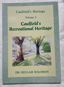
Book, Solomon, Geulah, Caulfield's Recreational Heritage : Caulfield's Heritage :Volume 3, 1989
... Caulfield buildings Heritage buildings ill., maps, ports. ; Vols. 1-4 together in case. ...ill., maps, ports. ; Vols. 1-4 together in case. Includes bibliographies and indexes.non-fictioncaulfield, buildings, heritage buildings -
 City of Moorabbin Historical Society (Operating the Box Cottage Museum)
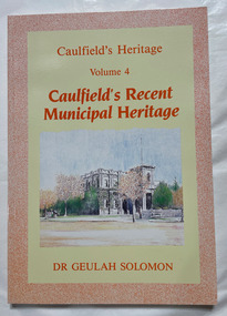
Book, Solomon, Geulah, Caulfield's Recent Municipal Heritage : Caulfield's Heritage :Volume 4, 1989
... Caulfield buildings Heritage buildings ill., maps, ports. ; Vols. 1-4 together in case. ...ill., maps, ports. ; Vols. 1-4 together in case. Includes bibliographies and indexes.non-fictioncaulfield, buildings, heritage buildings -
Glen Eira Historical Society
Letter - Howitt Road, 32, Caulfield North, Fooks House
... City of Glen Eira Fooks House Howitt Road Caulfield North Heritage studies The National Trust of Australia (Victoria) Historic buildings Letter Howitt Road, 32, Caulfield North, Fooks House ...A copy of a one page typed letter from Ian Pausacker of the National Trust of Australia (Victoria) to the Manager of the Planning Section of the City of Glen Eira, dated 08/02/2002, informing the Manager that Fooks House at 32 Howitt Road, Caulfield north has been classified by the National Trust.city of glen eira, fooks house, howitt road, caulfield north, heritage studies, the national trust of australia (victoria), historic buildings -
Glen Eira Historical Society
Document - Linlithgow Ave, 4 Caulfield North
... A heritage study from the City of Glen Eira Heritage Management Plan by Andrew Ward, 1996 on Linlithgow, 4 Linlithgow Avenue, Caulfield North. Report details the building’s significance, history and exterior and interior features. ...A heritage study from the City of Glen Eira Heritage Management Plan by Andrew Ward, 1996 on Linlithgow, 4 Linlithgow Avenue, Caulfield North. Report details the building’s significance, history and exterior and interior features. ...A heritage study from the City of Glen Eira Heritage Management Plan by Andrew Ward, 1996 on Linlithgow, 4 Linlithgow Avenue, Caulfield North. Report details the building’s significance, history and exterior and interior features. Includes references and a photocopied black and white photograph of the exterior.linlithgow, linlithgow avenue, linlithgow co-ed college, caulfield north, ward andrew, streamline moderne, art deco, duncan william, melbourne jockeys premiership, melbourne cup, slaney h, glen eira road, wood samuel, wood muriel, bambra road, jackson archibald, golding elizabeth, inkerman hotel, stables, horse racing, horse training, city of glen eira heritage management plan, haase eva nm, favelle bessie bain, favelle jack joseph, architectural styles, architectural features -
Glen Eira Historical Society
Article - Grand Union Tramway Junction, Balaclava Road and Hawthorn Road
... Caulfield Park... Tram systems... Tram networks... Heritage... Tramway Heritage... Kings Keith... Tram depots... Glenhuntly Depot... Maps... Glen Eira... Melbourne Electric Tramways... North Melbourne Electric Tramways and Lighting Co.... Prahran and Malvern Tramways Trust... Caulfield Leader... Bayside Weekly... Tooke Craig... Tourist attractions... Grand Union Tramways Junction... Caulfield Junction... Cable Car Tramways... Tram shelters... Building...Caulfield Caulfield Conservation Study Balaclava Road Hawthorn Road Grand Union Junction Ward Andrew Tramway Crossings Transport Acland Street Caulfield Racecourse Tram tracks Race events Event Tram routes Thorough fares Melbourne and Metropolitan Tramways Board Prahran and Malvern Tramway Trust Prahran and Malvern District Tramways Caulfield Electric Tramways Caulfield City Council Architectural detail City of Glen Eira Balaclava Road and Hawthorn Road intersection Balaclava Road and Hawthorn Road Junction Dandenong Road Glenhuntly Road Four-way Tram Junctions Access covers Darling Road Cast Metal Access covers Hadfields Patent Caulfield Park Tram systems Tram networks Heritage Tramway Heritage Kings Keith Tram depots Glenhuntly Depot Maps Glen Eira Melbourne Electric Tramways North Melbourne Electric Tramways and Lighting Co. Prahran and Malvern Tramways Trust Caulfield Leader Bayside Weekly Tooke Craig Tourist attractions Grand Union Tramways Junction Caulfield Junction Cable Car Tramways Tram shelters Building Sheds Alma Road Orrong Road Caulfield Electric Line Balaclava Junction Elsternwick Railway Station Caulfield station Caulfield Station loop Tram services Transport establishments Thoroughfares Buildings Structures Establishments Parts of buildings or structures Documents Commercial industry Sites Historic sites Melbourne Bayside Weekly Article Grand Union Tramway Junction, Balaclava Road and Hawthorn Road ...This file contains three items. 1. A three-page Caulfield Conservation Study of the Balaclava Road/Hawthorn Road Tramway Crossing, undertake by Andrew Ward and dated September 1994. Study includes a brief history of the junction and a statement of significance. Study also includes Four black and white photographs of the junction and of architectural details of the tram tracks. 2. A letter from the Conservation Manager of the National Trust of Australia (Victoria) to the manager of the Planning Section for the City of Glen Eira, dated 15/06/2001 and attached to a six-page Classification Report. The letter informs of the Classification of the Grand Union Junction at the intersection of Balaclava and Hawthorn Road by the national trust, signed by Conservation Manager Ian Pausacker. Classification Report includes details such as the date of construction, a statement of significance, history of the junction, physical description of the junction and the condition of the junction at the time of writing. Report also includes a map of the Melbourne Tram Network drafted by Keith Kings and dated 01/005/1956, with illustration of the layout of fifteen tram depots, and updated aerial illustration of the Grand Union Junction, and a further map of Melbourne Tramways developed by North Melbourne Electric Tramways and Lighting Co. and Prahran and Malvern Tramways Trust, drafted by Keith Kings and dated January 1914 with illustrations of three tram depots. 3. Two articles from the Caulfield Leader written by Aaron Langmaid and dated 13/02/2007 and the Melbourne Bayside Weekly dated 21/02/2007 written by Joanne Sim, both concerning the Grand Union Junction. The article from the Caulfield Leader includes a picture of Executive Officer of the council of Tramway Museum of Australia Craig Tooke in front of the intersection. The article from the Bayside Weekly includes a picture of a tram passing through the junction and a brief history of the junction and tram network in Caulfield. The article also refers to twp local tram shelters at the intersection of Dandenong Road and Alma Road and also Orrong Road and Balaclava Road.caulfield, caulfield conservation, study, balaclava road, hawthorn road, grand union junction, ward andrew, tramway crossings, transport, acland street, caulfield racecourse, tram tracks, race events, event, tram routes, thorough fares, melbourne and metropolitan tramways board, prahran and malvern tramway trust, prahran and malvern district tramways, caulfield electric tramways, caulfield city council, architectural detail, city of glen eira, balaclava road and hawthorn road intersection, balaclava road and hawthorn road junction, dandenong road, glenhuntly road, four-way tram junctions, access covers darling road, cast metal access covers, hadfields patent, caulfield park, tram systems, tram networks, heritage, tramway heritage, kings keith, tram depots, glenhuntly depot, maps, glen eira, melbourne electric tramways, north melbourne electric tramways and lighting co., prahran and malvern tramways trust, caulfield leader, bayside weekly, tooke craig, tourist attractions, grand union tramways junction, caulfield junction, cable car tramways, tram shelters, building, sheds, alma road, orrong road, caulfield electric line, balaclava junction, elsternwick railway station, caulfield station, caulfield station loop, tram services, transport establishments, thoroughfares, buildings, structures, establishments, parts of buildings or structures, documents, commercial industry, sites, historic sites, melbourne bayside weekly -
 Glen Eira Historical Society
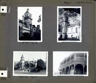
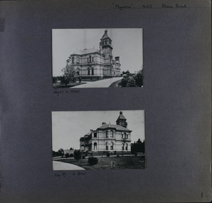
Album - Album page, Myoora, 405 Alma Road, Circa 1972
... Caulfield Historical Society to assist in identifying buildings worthy of preservation. The album is related to a Survey the Caulfield Historical Society developed in collaboration with the National Trust of Australia (Victoria) and Caulfield City Council to identify historic buildings within the City of Caulfield that warranted the protection of a National Trust Classification. Principal photographer thought to be Trevor Hart, member of Caulfield Historical Society. Most photographs were taken between 1966-1972 with a small number of photographs being older and from unknown sources. All photographs are black and white except where stated, with 386 photographs over 198 pages. Myoora - Victorian Heritage ...This photograph is part of the Caulfield Historical Album 1972. This album was created in approximately 1972 as part of a project by the Caulfield Historical Society to assist in identifying buildings worthy of preservation. The album is related to a Survey the Caulfield Historical Society developed in collaboration with the National Trust of Australia (Victoria) and Caulfield City Council to identify historic buildings within the City of Caulfield that warranted the protection of a National Trust Classification. Principal photographer thought to be Trevor Hart, member of Caulfield Historical Society. Most photographs were taken between 1966-1972 with a small number of photographs being older and from unknown sources. All photographs are black and white except where stated, with 386 photographs over 198 pages. Myoora - Victorian Heritage Register (VHR) Number H0490 https://vhd.heritagecouncil.vic.gov.au/places/275 Myoora, 405 Alma Road, North Caulfield, was designed by Reed, Henderson & Smart and can be attributed to Anketell Henderson. It was built in 1886 and 1887 for Thomas Christian, who had founded the fabled gold mine, the Day Dawn at Charters Towers. He never occupied the house although his widow lived there for some time. The house was subdivided into three and later six flats. Myoora was one of many large mansions on broad acres with gardens in Caulfield. Perhaps the grandest was Labassa. The mansions date from the 1850s through to the late 1890s. The siting of Myoora on a ridge influenced its planning and composition. A central hall and corridor along the ridge is entered from the centre of the more formal north facade. The entrance is marked by an elaborately detailed tower. A stair turret provides a second accent. The western end of the building is completed by a massively detailed chimney as the service wing. The south facade enjoyed an outlook to port phillip from a two-storey cast iron verandah. Bay windows, chimneys, the tower and the turret and minor details are brought together in a sophisticated asymmetrical composition. This is reflected in the planning. The asymmetry of Myoora pivoting on the tower is the most notable feature of the building. The walls are built of cement rendered brick. The cement render has not been painted. The roof is slate. The balconies and verandah are cast iron. The footings and cellar are bluestone. The architectural firm Reed, Henderson & Smart was very prominent in Victoria in the nineteenth century. Anketell Henderson was an eminent and well respected member of the profession. He worked successfully in London and interstate as well as in Victoria. They were better known for commercial and public buildings. Myoora is an important private commission. The style of Myoora is a combination of details from the Continental and English Renaissance through the boom style and the Queen Anne style. There is also an early influence from the American Romanesque style especially in the stair turret. The latter style was important at the turn of the century and Myoora is a significant precursor. Other buildings of a similar scale survive in Caulfield and elsewhere. Labassa, the most fabulous, is quite different stylistically as are most of the other comparable mansions.Page 6 of Photograph Album including four black and white photographs of the mansion Myoora. Two photographs in the top half of the page are in portrait orientation while the two photographs in the bottom half of the page are in landscape orientation.Handwritten: "Myoora" 405 Alma Rd [top right hand corner] / 8 Oct 1966 Neg 229 [underneath top left photograph] / 8 Oct 1966 Neg 230 [underneath bottom left photograph] / 6 [bottom right]caulfield north, trevor hart, alma road, mansion, myoora, tower, lacework, arched windows, anketell henderson, thomas christian, 1880's, cement rendered brick, slate roof, cast iron verandah, cast iron balconies, bluestone footings, queen anne, american romanesque, bay windows, boom style, continental and english renaissance, cast iron work, reed henderson & smart, flats, gardens, asymmetrical style -
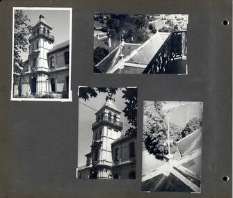 Glen Eira Historical Society
Album - Album page, Myoora, 405 Alma Road, Circa 1972
... Caulfield Historical Society to assist in identifying buildings worthy of preservation. The album is related to a Survey the Caulfield Historical Society developed in collaboration with the National Trust of Australia (Victoria) and Caulfield City Council to identify historic buildings within the City of Caulfield that warranted the protection of a National Trust Classification. Principal photographer thought to be Trevor Hart, member of Caulfield Historical Society. Most photographs were taken between 1966-1972 with a small number of photographs being older and from unknown sources. All photographs are black and white except where stated, with 386 photographs over 198 pages. Myoora - Victorian Heritage ...This photograph is part of the Caulfield Historical Album 1972. This album was created in approximately 1972 as part of a project by the Caulfield Historical Society to assist in identifying buildings worthy of preservation. The album is related to a Survey the Caulfield Historical Society developed in collaboration with the National Trust of Australia (Victoria) and Caulfield City Council to identify historic buildings within the City of Caulfield that warranted the protection of a National Trust Classification. Principal photographer thought to be Trevor Hart, member of Caulfield Historical Society. Most photographs were taken between 1966-1972 with a small number of photographs being older and from unknown sources. All photographs are black and white except where stated, with 386 photographs over 198 pages. Myoora - Victorian Heritage Register (VHR) Number H0490 https://vhd.heritagecouncil.vic.gov.au/places/275 Myoora, 405 Alma Road, North Caulfield, was designed by Reed, Henderson & Smart and can be attributed to Anketell Henderson. It was built in 1886 and 1887 for Thomas Christian, who had founded the fabled gold mine, the Day Dawn at Charters Towers. He never occupied the house although his widow lived there for some time. The house was subdivided into three and later six flats. Myoora was one of many large mansions on broad acres with gardens in Caulfield. Perhaps the grandest was Labassa. The mansions date from the 1850s through to the late 1890s. The siting of Myoora on a ridge influenced its planning and composition. A central hall and corridor along the ridge is entered from the centre of the more formal north facade. The entrance is marked by an elaborately detailed tower. A stair turret provides a second accent. The western end of the building is completed by a massively detailed chimney as the service wing. The south facade enjoyed an outlook to port phillip from a two-storey cast iron verandah. Bay windows, chimneys, the tower and the turret and minor details are brought together in a sophisticated asymmetrical composition. This is reflected in the planning. The asymmetry of Myoora pivoting on the tower is the most notable feature of the building. The walls are built of cement rendered brick. The cement render has not been painted. The roof is slate. The balconies and verandah are cast iron. The footings and cellar are bluestone. The architectural firm Reed, Henderson & Smart was very prominent in Victoria in the nineteenth century. Anketell Henderson was an eminent and well respected member of the profession. He worked successfully in London and interstate as well as in Victoria. They were better known for commercial and public buildings. Myoora is an important private commission. The style of Myoora is a combination of details from the Continental and English Renaissance through the boom style and the Queen Anne style. There is also an early influence from the American Romanesque style especially in the stair turret. The latter style was important at the turn of the century and Myoora is a significant precursor. Other buildings of a similar scale survive in Caulfield and elsewhere. Labassa, the most fabulous, is quite different stylistically as are most of the other comparable mansions.Page 7 of Photograph Album including four black and white photographs. Three photos are in a portrait orientation and placed diagonally across the page from the top left hand side to the bottom right hand side. One photograph in a landscape orientation is on the top right hand side of the page. Handwritten: 007 (bottom left hand corner)caulfield north, trevor hart, alma road, mansion, myoora, tower, thomas christian, 1880's, queen anne, cement rendered brick, unpainted, balconies, verandahs, anketell henderson, continental and english renaissance, american romanesque, views, cast iron work, reed henderson & smart, flats, gardens, asymmetrical style, slate roofs -
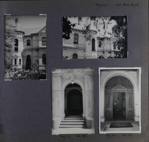 Glen Eira Historical Society
Album - Album page, Myoora, 405 Alma Road, Circa 1972
... Caulfield Historical Society to assist in identifying buildings worthy of preservation. The album is related to a Survey the Caulfield Historical Society developed in collaboration with the National Trust of Australia (Victoria) and Caulfield City Council to identify historic buildings within the City of Caulfield that warranted the protection of a National Trust Classification. Principal photographer thought to be Trevor Hart, member of Caulfield Historical Society. Most photographs were taken between 1966-1972 with a small number of photographs being older and from unknown sources. All photographs are black and white except where stated, with 386 photographs over 198 pages. Myoora - Victorian Heritage ...This photograph is part of the Caulfield Historical Album 1972. This album was created in approximately 1972 as part of a project by the Caulfield Historical Society to assist in identifying buildings worthy of preservation. The album is related to a Survey the Caulfield Historical Society developed in collaboration with the National Trust of Australia (Victoria) and Caulfield City Council to identify historic buildings within the City of Caulfield that warranted the protection of a National Trust Classification. Principal photographer thought to be Trevor Hart, member of Caulfield Historical Society. Most photographs were taken between 1966-1972 with a small number of photographs being older and from unknown sources. All photographs are black and white except where stated, with 386 photographs over 198 pages.Myoora - Victorian Heritage Register (VHR) Number H0490 https://vhd.heritagecouncil.vic.gov.au/places/275 (as at 6/10/2020) Myoora, 405 Alma Road, North Caulfield, was designed by Reed, Henderson & Smart and can be attributed to Anketell Henderson. It was built in 1886 and 1887 for Thomas Christian, who had founded the fabled gold mine, the Day Dawn at Charters Towers. He never occupied the house although his widow lived there for some time. The house was subdivided into three and later six flats. Myoora was one of many large mansions on broad acres with gardens in Caulfield. Perhaps the grandest was Labassa. The mansions date from the 1850s through to the late 1890s. The siting of Myoora on a ridge influenced its planning and composition. A central hall and corridor along the ridge is entered from the centre of the more formal north facade. The entrance is marked by an elaborately detailed tower. A stair turret provides a second accent. The western end of the building is completed by a massively detailed chimney as the service wing. The south facade enjoyed an outlook to port phillip from a two-storey cast iron verandah. Bay windows, chimneys, the tower and the turret and minor details are brought together in a sophisticated asymmetrical composition. This is reflected in the planning. The asymmetry of Myoora pivoting on the tower is the most notable feature of the building. The walls are built of cement rendered brick. The cement render has not been painted. The roof is slate. The balconies and verandah are cast iron. The footings and cellar are bluestone. The architectural firm Reed, Henderson & Smart was very prominent in Victoria in the nineteenth century. Anketell Henderson was an eminent and well respected member of the profession. He worked successfully in London and interstate as well as in Victoria. They were better known for commercial and public buildings. Myoora is an important private commission. The style of Myoora is a combination of details from the Continental and English Renaissance through the boom style and the Queen Anne style. There is also an early influence from the American Romanesque style especially in the stair turret. The latter style was important at the turn of the century and Myoora is a significant precursor. Other buildings of a similar scale survive in Caulfield and elsewhere. Labassa, the most fabulous, is quite different stylistically as are most of the other comparable mansions. Stonnington is perhaps closer but relies on different details from the Queen Anne style and lacks any American influence. For its historical associations through its owners and architects, for its style and composition and for its intactness, Myoora is significant at a State level. The craftmanship of Myoora is what could be expected of a building of the time and type. It is relatively intact and in fair condition. The main staircase has been removed, minor alterations to decorative features have occurred and additions have been made to the exterior.Page 8 of Photograph Album including four black and white photographs. Three photos are in a portrait orientation, one on the left hand side of the page with the other two in the bottom part of the page. One photograph in a landscape orientation is on the top right hand side of the page. Handwritten: "Myoora" 405 Alma Rd [top right hand corner] / Neg 179 DEC 1972 [underneath bottom left photograph] / Neg 180 DEC 1972 [underneath bottom right photograph] / 8 [bottom right]caulfield north, trevor hart, alma road, mansion, myoora, tower, thomas christian, 1880's, queen anne, cement rendered brick, unpainted, balconies, verandahs, anketell henderson, continental and english renaissance, american romanesque, views, cast iron work, reed henderson & smart, flats, gardens, asymmetrical style, slate roofs, entrances -
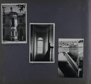 Glen Eira Historical Society
Album - Album page, Myoora, 405 Alma Road, Circa 1972
... Caulfield Historical Society to assist in identifying buildings worthy of preservation. The album is related to a Survey the Caulfield Historical Society developed in collaboration with the National Trust of Australia (Victoria) and Caulfield City Council to identify historic buildings within the City of Caulfield that warranted the protection of a National Trust Classification. Principal photographer thought to be Trevor Hart, member of Caulfield Historical Society. Most photographs were taken between 1966-1972 with a small number of photographs being older and from unknown sources. All photographs are black and white except where stated, with 386 photographs over 198 pages. Myoora - Victorian Heritage ...This photograph is part of the Caulfield Historical Album 1972. This album was created in approximately 1972 as part of a project by the Caulfield Historical Society to assist in identifying buildings worthy of preservation. The album is related to a Survey the Caulfield Historical Society developed in collaboration with the National Trust of Australia (Victoria) and Caulfield City Council to identify historic buildings within the City of Caulfield that warranted the protection of a National Trust Classification. Principal photographer thought to be Trevor Hart, member of Caulfield Historical Society. Most photographs were taken between 1966-1972 with a small number of photographs being older and from unknown sources. All photographs are black and white except where stated, with 386 photographs over 198 pages.Myoora - Victorian Heritage Register (VHR) Number H0490 From the Victorian Heritage Register Database - Citation for Myoora https://vhd.heritagecouncil.vic.gov.au/places/275 (as at 6/10/2020) Myoora, 405 Alma Road, North Caulfield, was designed by Reed, Henderson & Smart and can be attributed to Anketell Henderson. It was built in 1886 and 1887 for Thomas Christian, who had founded the fabled gold mine, the Day Dawn at Charters Towers. He never occupied the house although his widow lived there for some time. The house was subdivided into three and later six flats. Myoora was one of many large mansions on broad acres with gardens in Caulfield. Perhaps the grandest was Labassa. The mansions date from the 1850s through to the late 1890s. The siting of Myoora on a ridge influenced its planning and composition. A central hall and corridor along the ridge is entered from the centre of the more formal north facade. The entrance is marked by an elaborately detailed tower. A stair turret provides a second accent. The western end of the building is completed by a massively detailed chimney as the service wing. The south facade enjoyed an outlook to port phillip from a two-storey cast iron verandah. Bay windows, chimneys, the tower and the turret and minor details are brought together in a sophisticated asymmetrical composition. This is reflected in the planning. The asymmetry of Myoora pivoting on the tower is the most notable feature of the building. The walls are built of cement rendered brick. The cement render has not been painted. The roof is slate. The balconies and verandah are cast iron. The footings and cellar are bluestone. The architectural firm Reed, Henderson & Smart was very prominent in Victoria in the nineteenth century. Anketell Henderson was an eminent and well respected member of the profession. He worked successfully in London and interstate as well as in Victoria. They were better known for commercial and public buildings. Myoora is an important private commission. The style of Myoora is a combination of details from the Continental and English Renaissance through the boom style and the Queen Anne style. There is also an early influence from the American Romanesque style especially in the stair turret. The latter style was important at the turn of the century and Myoora is a significant precursor. Other buildings of a similar scale survive in Caulfield and elsewhere. Labassa, the most fabulous, is quite different stylistically as are most of the other comparable mansions. Stonnington is perhaps closer but relies on different details from the Queen Anne style and lacks any American influence. For its historical associations through its owners and architects, for its style and composition and for its intactness, Myoora is significant at a State level. The craftmanship of Myoora is what could be expected of a building of the time and type. It is relatively intact and in fair condition. The main staircase has been removed, minor alterations to decorative features have occurred and additions have been made to the exterior.Page 9 of Photograph Album including three black and white photographs. The photos are in a portrait orientation and arranged diagonally across the page from top left to bottom right.Handwritten: Neg 175 DEC 1972 [underneath top left photograph] / Neg 173 DEC 1972 [underneath middle photograph] / 9 [bottom left]caulfield north, trevor hart, alma road, mansion, myoora, tower, thomas christian, 1880's, queen anne, cement rendered brick, unpainted, balconies, verandahs, anketell henderson, continental and english renaissance, american romanesque, views, cast iron work, reed henderson & smart, flats, asymmetrical style, slate roofs, windows -
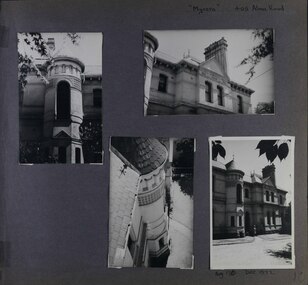 Glen Eira Historical Society
Album - Album page, Myoora, 405 Alma Road, Circa 1972
... Caulfield Historical Society to assist in identifying buildings worthy of preservation. The album is related to a Survey the Caulfield Historical Society developed in collaboration with the National Trust of Australia (Victoria) and Caulfield City Council to identify historic buildings within the City of Caulfield that warranted the protection of a National Trust Classification. Principal photographer thought to be Trevor Hart, member of Caulfield Historical Society. Most photographs were taken between 1966-1972 with a small number of photographs being older and from unknown sources. All photographs are black and white except where stated, with 386 photographs over 198 pages. Myoora - Victorian Heritage ...This photograph is part of the Caulfield Historical Album 1972. This album was created in approximately 1972 as part of a project by the Caulfield Historical Society to assist in identifying buildings worthy of preservation. The album is related to a Survey the Caulfield Historical Society developed in collaboration with the National Trust of Australia (Victoria) and Caulfield City Council to identify historic buildings within the City of Caulfield that warranted the protection of a National Trust Classification. Principal photographer thought to be Trevor Hart, member of Caulfield Historical Society. Most photographs were taken between 1966-1972 with a small number of photographs being older and from unknown sources. All photographs are black and white except where stated, with 386 photographs over 198 pages.Myoora - Victorian Heritage Register (VHR) Number H0490 Citation for Myoora https://vhd.heritagecouncil.vic.gov.au/places/275 (as at 6/10/2020) Myoora, 405 Alma Road, North Caulfield, was designed by Reed, Henderson & Smart and can be attributed to Anketell Henderson. It was built in 1886 and 1887 for Thomas Christian, who had founded the fabled gold mine, the Day Dawn at Charters Towers. He never occupied the house although his widow lived there for some time. The house was subdivided into three and later six flats. Myoora was one of many large mansions on broad acres with gardens in Caulfield. Perhaps the grandest was Labassa. The mansions date from the 1850s through to the late 1890s. The siting of Myoora on a ridge influenced its planning and composition. A central hall and corridor along the ridge is entered from the centre of the more formal north facade. The entrance is marked by an elaborately detailed tower. A stair turret provides a second accent. The western end of the building is completed by a massively detailed chimney as the service wing. The south facade enjoyed an outlook to port phillip from a two-storey cast iron verandah. Bay windows, chimneys, the tower and the turret and minor details are brought together in a sophisticated asymmetrical composition. This is reflected in the planning. The asymmetry of Myoora pivoting on the tower is the most notable feature of the building. The walls are built of cement rendered brick. The cement render has not been painted. The roof is slate. The balconies and verandah are cast iron. The footings and cellar are bluestone. The architectural firm Reed, Henderson & Smart was very prominent in Victoria in the nineteenth century. Anketell Henderson was an eminent and well respected member of the profession. He worked successfully in London and interstate as well as in Victoria. They were better known for commercial and public buildings. Myoora is an important private commission. The style of Myoora is a combination of details from the Continental and English Renaissance through the boom style and the Queen Anne style. There is also an early influence from the American Romanesque style especially in the stair turret. The latter style was important at the turn of the century and Myoora is a significant precursor. Other buildings of a similar scale survive in Caulfield and elsewhere. Labassa, the most fabulous, is quite different stylistically as are most of the other comparable mansions. Stonnington is perhaps closer but relies on different details from the Queen Anne style and lacks any American influence. For its historical associations through its owners and architects, for its style and composition and for its intactness, Myoora is significant at a State level. The craftmanship of Myoora is what could be expected of a building of the time and type. It is relatively intact and in fair condition. The main staircase has been removed, minor alterations to decorative features have occurred and additions have been made to the exterior.Page 10 of Photograph Album including four black and white photographs. Three photos are in a portrait orientation with the fourth on the right in a landscape orientation.Handwritten: "Myoora" 405 Alma Rd [top right of page] / Neg 176 DEC 1972 [underneath bottom right photograph] / 10 [bottom right]caulfield north, trevor hart, alma road, mansion, myoora, tower, thomas christian, 1880's, queen anne, cement rendered brick, unpainted, balconies, verandahs, anketell henderson, continental and english renaissance, american romanesque, cast iron work, reed henderson & smart, flats, gardens, asymmetrical style, slate roofs, chimneys -
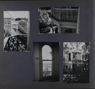 Glen Eira Historical Society
Album - Album page, Myoora, 405 Alma Road, Circa 1972
... Caulfield Historical Society to assist in identifying buildings worthy of preservation. The album is related to a Survey the Caulfield Historical Society developed in collaboration with the National Trust of Australia (Victoria) and Caulfield City Council to identify historic buildings within the City of Caulfield that warranted the protection of a National Trust Classification. Principal photographer thought to be Trevor Hart, member of Caulfield Historical Society. Most photographs were taken between 1966-1972 with a small number of photographs being older and from unknown sources. All photographs are black and white except where stated, with 386 photographs over 198 pages. Victorian Heritage ...This photograph is part of the Caulfield Historical Album 1972. This album was created in approximately 1972 as part of a project by the Caulfield Historical Society to assist in identifying buildings worthy of preservation. The album is related to a Survey the Caulfield Historical Society developed in collaboration with the National Trust of Australia (Victoria) and Caulfield City Council to identify historic buildings within the City of Caulfield that warranted the protection of a National Trust Classification. Principal photographer thought to be Trevor Hart, member of Caulfield Historical Society. Most photographs were taken between 1966-1972 with a small number of photographs being older and from unknown sources. All photographs are black and white except where stated, with 386 photographs over 198 pages.Victorian Heritage Register (VHR) Number H0490 From the Victorian Heritage Register Database - Citation for Myoora https://vhd.heritagecouncil.vic.gov.au/places/275 (as at 6/10/2020) Myoora, 405 Alma Road, North Caulfield, was designed by Reed, Henderson & Smart and can be attributed to Anketell Henderson. It was built in 1886 and 1887 for Thomas Christian, who had founded the fabled gold mine, the Day Dawn at Charters Towers. He never occupied the house although his widow lived there for some time. The house was subdivided into three and later six flats. Myoora was one of many large mansions on broad acres with gardens in Caulfield. Perhaps the grandest was Labassa. The mansions date from the 1850s through to the late 1890s. The siting of Myoora on a ridge influenced its planning and composition. A central hall and corridor along the ridge is entered from the centre of the more formal north facade. The entrance is marked by an elaborately detailed tower. A stair turret provides a second accent. The western end of the building is completed by a massively detailed chimney as the service wing. The south facade enjoyed an outlook to port phillip from a two-storey cast iron verandah. Bay windows, chimneys, the tower and the turret and minor details are brought together in a sophisticated asymmetrical composition. This is reflected in the planning. The asymmetry of Myoora pivoting on the tower is the most notable feature of the building. The walls are built of cement rendered brick. The cement render has not been painted. The roof is slate. The balconies and verandah are cast iron. The footings and cellar are bluestone. The architectural firm Reed, Henderson & Smart was very prominent in Victoria in the nineteenth century. Anketell Henderson was an eminent and well respected member of the profession. He worked successfully in London and interstate as well as in Victoria. They were better known for commercial and public buildings. Myoora is an important private commission. The style of Myoora is a combination of details from the Continental and English Renaissance through the boom style and the Queen Anne style. There is also an early influence from the American Romanesque style especially in the stair turret. The latter style was important at the turn of the century and Myoora is a significant precursor. Other buildings of a similar scale survive in Caulfield and elsewhere. Labassa, the most fabulous, is quite different stylistically as are most of the other comparable mansions. Stonnington is perhaps closer but relies on different details from the Queen Anne style and lacks any American influence. For its historical associations through its owners and architects, for its style and composition and for its intactness, Myoora is significant at a State level. The craftmanship of Myoora is what could be expected of a building of the time and type. It is relatively intact and in fair condition. The main staircase has been removed, minor alterations to decorative features have occurred and additions have been made to the exterior.Page 11 of Photograph Album including four black and white photographs. Three photos are in a portrait orientation and arranged on the left and bottom section of the page. A landscape oriented photo is in the top right section.Handwritten: 11 [bottom left]caulfield north, trevor hart, alma road, mansion, myoora, tower, thomas christian, 1880's, queen anne, cement rendered brick, unpainted, balconies, verandahs, anketell henderson, continental and english renaissance, american romanesque, cast iron balconies, views, cast iron work, reed henderson & smart, flats, gardens, asymmetrical style, slate roofs, windows, chimneys -
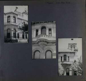 Glen Eira Historical Society
Album - Album page, Myoora, 405 Alma Road, Circa 1972
... Caulfield Historical Society to assist in identifying buildings worthy of preservation. The album is related to a Survey the Caulfield Historical Society developed in collaboration with the National Trust of Australia (Victoria) and Caulfield City Council to identify historic buildings within the City of Caulfield that warranted the protection of a National Trust Classification. Principal photographer thought to be Trevor Hart, member of Caulfield Historical Society. Most photographs were taken between 1966-1972 with a small number of photographs being older and from unknown sources. All photographs are black and white except where stated, with 386 photographs over 198 pages. Victorian Heritage ...This photograph is part of the Caulfield Historical Album 1972. This album was created in approximately 1972 as part of a project by the Caulfield Historical Society to assist in identifying buildings worthy of preservation. The album is related to a Survey the Caulfield Historical Society developed in collaboration with the National Trust of Australia (Victoria) and Caulfield City Council to identify historic buildings within the City of Caulfield that warranted the protection of a National Trust Classification. Principal photographer thought to be Trevor Hart, member of Caulfield Historical Society. Most photographs were taken between 1966-1972 with a small number of photographs being older and from unknown sources. All photographs are black and white except where stated, with 386 photographs over 198 pages.Victorian Heritage Register (VHR) Number H0490 From the Victorian Heritage Register Database - Citation for Myoora https://vhd.heritagecouncil.vic.gov.au/places/275 (as at 6/10/2020) Myoora, 405 Alma Road, North Caulfield, was designed by Reed, Henderson & Smart and can be attributed to Anketell Henderson. It was built in 1886 and 1887 for Thomas Christian, who had founded the fabled gold mine, the Day Dawn at Charters Towers. He never occupied the house although his widow lived there for some time. The house was subdivided into three and later six flats. Myoora was one of many large mansions on broad acres with gardens in Caulfield. Perhaps the grandest was Labassa. The mansions date from the 1850s through to the late 1890s. The siting of Myoora on a ridge influenced its planning and composition. A central hall and corridor along the ridge is entered from the centre of the more formal north facade. The entrance is marked by an elaborately detailed tower. A stair turret provides a second accent. The western end of the building is completed by a massively detailed chimney as the service wing. The south facade enjoyed an outlook to port phillip from a two-storey cast iron verandah. Bay windows, chimneys, the tower and the turret and minor details are brought together in a sophisticated asymmetrical composition. This is reflected in the planning. The asymmetry of Myoora pivoting on the tower is the most notable feature of the building. The walls are built of cement rendered brick. The cement render has not been painted. The roof is slate. The balconies and verandah are cast iron. The footings and cellar are bluestone. The architectural firm Reed, Henderson & Smart was very prominent in Victoria in the nineteenth century. Anketell Henderson was an eminent and well respected member of the profession. He worked successfully in London and interstate as well as in Victoria. They were better known for commercial and public buildings. Myoora is an important private commission. The style of Myoora is a combination of details from the Continental and English Renaissance through the boom style and the Queen Anne style. There is also an early influence from the American Romanesque style especially in the stair turret. The latter style was important at the turn of the century and Myoora is a significant precursor. Other buildings of a similar scale survive in Caulfield and elsewhere. Labassa, the most fabulous, is quite different stylistically as are most of the other comparable mansions. Stonnington is perhaps closer but relies on different details from the Queen Anne style and lacks any American influence. For its historical associations through its owners and architects, for its style and composition and for its intactness, Myoora is significant at a State level. The craftmanship of Myoora is what could be expected of a building of the time and type. It is relatively intact and in fair condition. The main staircase has been removed, minor alterations to decorative features have occurred and additions have been made to the exterior.Page 12 of Photograph Album including three black and white photographs. The photos are in a portrait orientation and arranged diagonally across the page from top left to bottom right.Handwritten: "Myoora" 405 Alma Road[top right] /12 [bottom left]caulfield north, trevor hart, alma road, mansion, myoora, tower, thomas christian, 1880's, queen anne, cement rendered brick, unpainted, balconies, verandahs, anketell henderson, continental and english renaissance, american romanesque, cast iron balconies, cast iron work, reed henderson & smart, flats, asymmetrical style, slate roofs -
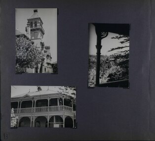 Glen Eira Historical Society
Album - Album page, Myoora, 405 Alma Road, Circa 1972
... Caulfield Historical Society to assist in identifying buildings worthy of preservation. The album is related to a Survey the Caulfield Historical Society developed in collaboration with the National Trust of Australia (Victoria) and Caulfield City Council to identify historic buildings within the City of Caulfield that warranted the protection of a National Trust Classification. Principal photographer thought to be Trevor Hart, member of Caulfield Historical Society. Most photographs were taken between 1966-1972 with a small number of photographs being older and from unknown sources. All photographs are black and white except where stated, with 386 photographs over 198 pages. Victorian Heritage ...This photograph is part of the Caulfield Historical Album 1972. This album was created in approximately 1972 as part of a project by the Caulfield Historical Society to assist in identifying buildings worthy of preservation. The album is related to a Survey the Caulfield Historical Society developed in collaboration with the National Trust of Australia (Victoria) and Caulfield City Council to identify historic buildings within the City of Caulfield that warranted the protection of a National Trust Classification. Principal photographer thought to be Trevor Hart, member of Caulfield Historical Society. Most photographs were taken between 1966-1972 with a small number of photographs being older and from unknown sources. All photographs are black and white except where stated, with 386 photographs over 198 pages.Victorian Heritage Register (VHR) Number H0490 From the Victorian Heritage Register Database - Citation for Myoora https://vhd.heritagecouncil.vic.gov.au/places/275 (as at 6/10/2020) Myoora, 405 Alma Road, North Caulfield, was designed by Reed, Henderson & Smart and can be attributed to Anketell Henderson. It was built in 1886 and 1887 for Thomas Christian, who had founded the fabled gold mine, the Day Dawn at Charters Towers. He never occupied the house although his widow lived there for some time. The house was subdivided into three and later six flats. Myoora was one of many large mansions on broad acres with gardens in Caulfield. Perhaps the grandest was Labassa. The mansions date from the 1850s through to the late 1890s. The siting of Myoora on a ridge influenced its planning and composition. A central hall and corridor along the ridge is entered from the centre of the more formal north facade. The entrance is marked by an elaborately detailed tower. A stair turret provides a second accent. The western end of the building is completed by a massively detailed chimney as the service wing. The south facade enjoyed an outlook to port phillip from a two-storey cast iron verandah. Bay windows, chimneys, the tower and the turret and minor details are brought together in a sophisticated asymmetrical composition. This is reflected in the planning. The asymmetry of Myoora pivoting on the tower is the most notable feature of the building. The walls are built of cement rendered brick. The cement render has not been painted. The roof is slate. The balconies and verandah are cast iron. The footings and cellar are bluestone. The architectural firm Reed, Henderson & Smart was very prominent in Victoria in the nineteenth century. Anketell Henderson was an eminent and well respected member of the profession. He worked successfully in London and interstate as well as in Victoria. They were better known for commercial and public buildings. Myoora is an important private commission. The style of Myoora is a combination of details from the Continental and English Renaissance through the boom style and the Queen Anne style. There is also an early influence from the American Romanesque style especially in the stair turret. The latter style was important at the turn of the century and Myoora is a significant precursor. Other buildings of a similar scale survive in Caulfield and elsewhere. Labassa, the most fabulous, is quite different stylistically as are most of the other comparable mansions. Stonnington is perhaps closer but relies on different details from the Queen Anne style and lacks any American influence. For its historical associations through its owners and architects, for its style and composition and for its intactness, Myoora is significant at a State level. The craftmanship of Myoora is what could be expected of a building of the time and type. It is relatively intact and in fair condition. The main staircase has been removed, minor alterations to decorative features have occurred and additions have been made to the exterior.Page 13 of Photograph Album including three black and white photographs. Two of the photos are in a portrait orientation and arranged in the top half of the page. The other photo in landscape orientation is towards the left on the bottom section of the page.Handwritten: 13 [bottom left]caulfield north, trevor hart, alma road, mansion, myoora, tower, thomas christian, 1880's, queen anne, cement rendered brick, unpainted, balconies, verandahs, anketell henderson, continental and english renaissance, american romanesque, cast iron balconies, views, cast iron work, reed henderson & smart, flats, gardens, asymmetrical style, slate roofs -
 Glen Eira Historical Society
Album - Album page, Myoora, 405 Alma Road, Circa 1972
... Caulfield Historical Society to assist in identifying buildings worthy of preservation. The album is related to a Survey the Caulfield Historical Society developed in collaboration with the National Trust of Australia (Victoria) and Caulfield City Council to identify historic buildings within the City of Caulfield that warranted the protection of a National Trust Classification. Principal photographer thought to be Trevor Hart, member of Caulfield Historical Society. Most photographs were taken between 1966-1972 with a small number of photographs being older and from unknown sources. All photographs are black and white except where stated, with 386 photographs over 198 pages. Victorian Heritage ...This photograph is part of the Caulfield Historical Album 1972. This album was created in approximately 1972 as part of a project by the Caulfield Historical Society to assist in identifying buildings worthy of preservation. The album is related to a Survey the Caulfield Historical Society developed in collaboration with the National Trust of Australia (Victoria) and Caulfield City Council to identify historic buildings within the City of Caulfield that warranted the protection of a National Trust Classification. Principal photographer thought to be Trevor Hart, member of Caulfield Historical Society. Most photographs were taken between 1966-1972 with a small number of photographs being older and from unknown sources. All photographs are black and white except where stated, with 386 photographs over 198 pages.Victorian Heritage Register (VHR) Number H0490 From the Victorian Heritage Register Database - Citation for Myoora https://vhd.heritagecouncil.vic.gov.au/places/275 (as at 6/10/2020) Myoora, 405 Alma Road, North Caulfield, was designed by Reed, Henderson & Smart and can be attributed to Anketell Henderson. It was built in 1886 and 1887 for Thomas Christian, who had founded the fabled gold mine, the Day Dawn at Charters Towers. He never occupied the house although his widow lived there for some time. The house was subdivided into three and later six flats. Myoora was one of many large mansions on broad acres with gardens in Caulfield. Perhaps the grandest was Labassa. The mansions date from the 1850s through to the late 1890s. The siting of Myoora on a ridge influenced its planning and composition. A central hall and corridor along the ridge is entered from the centre of the more formal north facade. The entrance is marked by an elaborately detailed tower. A stair turret provides a second accent. The western end of the building is completed by a massively detailed chimney as the service wing. The south facade enjoyed an outlook to port phillip from a two-storey cast iron verandah. Bay windows, chimneys, the tower and the turret and minor details are brought together in a sophisticated asymmetrical composition. This is reflected in the planning. The asymmetry of Myoora pivoting on the tower is the most notable feature of the building. The walls are built of cement rendered brick. The cement render has not been painted. The roof is slate. The balconies and verandah are cast iron. The footings and cellar are bluestone. The architectural firm Reed, Henderson & Smart was very prominent in Victoria in the nineteenth century. Anketell Henderson was an eminent and well respected member of the profession. He worked successfully in London and interstate as well as in Victoria. They were better known for commercial and public buildings. Myoora is an important private commission. The style of Myoora is a combination of details from the Continental and English Renaissance through the boom style and the Queen Anne style. There is also an early influence from the American Romanesque style especially in the stair turret. The latter style was important at the turn of the century and Myoora is a significant precursor. Other buildings of a similar scale survive in Caulfield and elsewhere. Labassa, the most fabulous, is quite different stylistically as are most of the other comparable mansions. Stonnington is perhaps closer but relies on different details from the Queen Anne style and lacks any American influence. For its historical associations through its owners and architects, for its style and composition and for its intactness, Myoora is significant at a State level. The craftmanship of Myoora is what could be expected of a building of the time and type. It is relatively intact and in fair condition. The main staircase has been removed, minor alterations to decorative features have occurred and additions have been made to the exterior.Page 14 of Photograph Album including two black and white photographs that are arranged in landscape orientation in the centre of the page with one beneath the other. Handwritten: "Myoora" 405 Alma Road [top right] /Neg 87 c1890 [under top photo]/ Neg 89 c1890/ [under bottom photo]/ 14 [bottom right]caulfield north, trevor hart, alma road, mansion, myoora, tower, thomas christian, 1880's, queen anne, cement rendered brick, unpainted, balconies, verandahs, anketell henderson, continental and english renaissance, american romanesque, cast iron balconies, gardens, views, cast iron work, reed henderson & smart, flats, asymmetrical style, slate roofs -
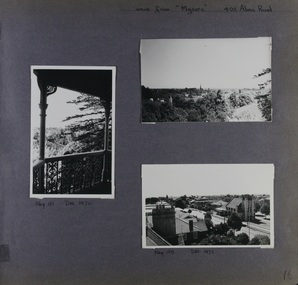 Glen Eira Historical Society
Album - Album page, Myoora, 405 Alma Road, Circa 1972
... Caulfield Historical Society to assist in identifying buildings worthy of preservation. The album is related to a Survey the Caulfield Historical Society developed in collaboration with the National Trust of Australia (Victoria) and Caulfield City Council to identify historic buildings within the City of Caulfield that warranted the protection of a National Trust Classification. Principal photographer thought to be Trevor Hart, member of Caulfield Historical Society. Most photographs were taken between 1966-1972 with a small number of photographs being older and from unknown sources. All photographs are black and white except where stated, with 386 photographs over 198 pages. Victorian Heritage ...This photograph is part of the Caulfield Historical Album 1972. This album was created in approximately 1972 as part of a project by the Caulfield Historical Society to assist in identifying buildings worthy of preservation. The album is related to a Survey the Caulfield Historical Society developed in collaboration with the National Trust of Australia (Victoria) and Caulfield City Council to identify historic buildings within the City of Caulfield that warranted the protection of a National Trust Classification. Principal photographer thought to be Trevor Hart, member of Caulfield Historical Society. Most photographs were taken between 1966-1972 with a small number of photographs being older and from unknown sources. All photographs are black and white except where stated, with 386 photographs over 198 pages.Victorian Heritage Register (VHR) Number H0490 From the Victorian Heritage Register Database - Citation for Myoora https://vhd.heritagecouncil.vic.gov.au/places/275 (as at 6/10/2020) Myoora, 405 Alma Road, North Caulfield, was designed by Reed, Henderson & Smart and can be attributed to Anketell Henderson. It was built in 1886 and 1887 for Thomas Christian, who had founded the fabled gold mine, the Day Dawn at Charters Towers. He never occupied the house although his widow lived there for some time. The house was subdivided into three and later six flats. Myoora was one of many large mansions on broad acres with gardens in Caulfield. Perhaps the grandest was Labassa. The mansions date from the 1850s through to the late 1890s. The siting of Myoora on a ridge influenced its planning and composition. A central hall and corridor along the ridge is entered from the centre of the more formal north facade. The entrance is marked by an elaborately detailed tower. A stair turret provides a second accent. The western end of the building is completed by a massively detailed chimney as the service wing. The south facade enjoyed an outlook to Port Phillip from a two-storey cast iron verandah. Bay windows, chimneys, the tower and the turret and minor details are brought together in a sophisticated asymmetrical composition. This is reflected in the planning. The asymmetry of Myoora pivoting on the tower is the most notable feature of the building. The walls are built of cement rendered brick. The cement render has not been painted. The roof is slate. The balconies and verandah are cast iron. The footings and cellar are bluestone. The architectural firm Reed, Henderson & Smart was very prominent in Victoria in the nineteenth century. Anketell Henderson was an eminent and well respected member of the profession. He worked successfully in London and interstate as well as in Victoria. They were better known for commercial and public buildings. Myoora is an important private commission. The style of Myoora is a combination of details from the Continental and English Renaissance through the boom style and the Queen Anne style. There is also an early influence from the American Romanesque style especially in the stair turret. The latter style was important at the turn of the century and Myoora is a significant precursor. Other buildings of a similar scale survive in Caulfield and elsewhere. Labassa, the most fabulous, is quite different stylistically as are most of the other comparable mansions. Stonnington is perhaps closer but relies on different details from the Queen Anne style and lacks any American influence. For its historical associations through its owners and architects, for its style and composition and for its intactness, Myoora is significant at a State level. The craftmanship of Myoora is what could be expected of a building of the time and type. It is relatively intact and in fair condition. The main staircase has been removed, minor alterations to decorative features have occurred and additions have been made to the exterior.Page 16 of Photograph Album including three black and white photographs. Two are arranged in landscape orientation on the right hand side of the page with the other photo in portrait mode on the left hand side. Handwritten: views from "Myoora" 405 Alma Road [top right] / Neg 181 Dec 1972 [under left side photo] / Neg 189 Dec 1972 [under bottom right photo] / 16 [bottom right]caulfield north, trevor hart, alma road, mansion, myoora, tower, thomas christian, 1880's, queen anne, cement rendered brick, unpainted, balconies, verandahs, anketell henderson, continental and english renaissance, american romanesque, cast iron balconies, panoramic views, streetscapes, cast iron work, reed henderson & smart, gardens, asymmetrical style, slate roofs, chimneys -
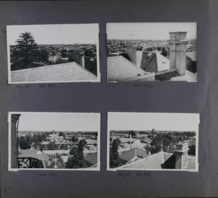 Glen Eira Historical Society
Album - Album page, Myoora, 405 Alma Road, Circa 1972
... Caulfield Historical Society to assist in identifying buildings worthy of preservation. The album is related to a Survey the Caulfield Historical Society developed in collaboration with the National Trust of Australia (Victoria) and Caulfield City Council to identify historic buildings within the City of Caulfield that warranted the protection of a National Trust Classification. Principal photographer thought to be Trevor Hart, member of Caulfield Historical Society. Most photographs were taken between 1966-1972 with a small number of photographs being older and from unknown sources. All photographs are black and white except where stated, with 386 photographs over 198 pages. Victorian Heritage ...This photograph is part of the Caulfield Historical Album 1972. This album was created in approximately 1972 as part of a project by the Caulfield Historical Society to assist in identifying buildings worthy of preservation. The album is related to a Survey the Caulfield Historical Society developed in collaboration with the National Trust of Australia (Victoria) and Caulfield City Council to identify historic buildings within the City of Caulfield that warranted the protection of a National Trust Classification. Principal photographer thought to be Trevor Hart, member of Caulfield Historical Society. Most photographs were taken between 1966-1972 with a small number of photographs being older and from unknown sources. All photographs are black and white except where stated, with 386 photographs over 198 pages.Victorian Heritage Register (VHR) Number H0490 From the Victorian Heritage Register Database - Citation for Myoora https://vhd.heritagecouncil.vic.gov.au/places/275 (as at 6/10/2020) Myoora, 405 Alma Road, North Caulfield, was designed by Reed, Henderson & Smart and can be attributed to Anketell Henderson. It was built in 1886 and 1887 for Thomas Christian, who had founded the fabled gold mine, the Day Dawn at Charters Towers. He never occupied the house although his widow lived there for some time. The house was subdivided into three and later six flats. Myoora was one of many large mansions on broad acres with gardens in Caulfield. Perhaps the grandest was Labassa. The mansions date from the 1850s through to the late 1890s. The siting of Myoora on a ridge influenced its planning and composition. A central hall and corridor along the ridge is entered from the centre of the more formal north facade. The entrance is marked by an elaborately detailed tower. A stair turret provides a second accent. The western end of the building is completed by a massively detailed chimney as the service wing. The south facade enjoyed an outlook to port phillip from a two-storey cast iron verandah. Bay windows, chimneys, the tower and the turret and minor details are brought together in a sophisticated asymmetrical composition. This is reflected in the planning. The asymmetry of Myoora pivoting on the tower is the most notable feature of the building. The walls are built of cement rendered brick. The cement render has not been painted. The roof is slate. The balconies and verandah are cast iron. The footings and cellar are bluestone. The architectural firm Reed, Henderson & Smart was very prominent in Victoria in the nineteenth century. Anketell Henderson was an eminent and well respected member of the profession. He worked successfully in London and interstate as well as in Victoria. They were better known for commercial and public buildings. Myoora is an important private commission. The style of Myoora is a combination of details from the Continental and English Renaissance through the boom style and the Queen Anne style. There is also an early influence from the American Romanesque style especially in the stair turret. The latter style was important at the turn of the century and Myoora is a significant precursor. Other buildings of a similar scale survive in Caulfield and elsewhere. Labassa, the most fabulous, is quite different stylistically as are most of the other comparable mansions. Stonnington is perhaps closer but relies on different details from the Queen Anne style and lacks any American influence. For its historical associations through its owners and architects, for its style and composition and for its intactness, Myoora is significant at a State level. The craftmanship of Myoora is what could be expected of a building of the time and type. It is relatively intact and in fair condition. The main staircase has been removed, minor alterations to decorative features have occurred and additions have been made to the exterior.Page 17 of Photograph Album including four black and white photographs. All are arranged in landscape orientation with two on the top half of the page and the other two below.Handwritten: Neg 185 Dec 1972 [under top left photo] / Dec 1972 [under top right photo] / Dec 1972 [under bottom left photo] / Neg 153 Dec 1972 [under bottom right photo] / 17 [bottom left]caulfield north, trevor hart, alma road, mansion, myoora, tower, thomas christian, 1880's, queen anne, cement rendered brick, unpainted, balconies, verandahs, anketell henderson, continental and english renaissance, american romanesque, cast iron balconies, panoramic views, streetscapes, cast iron work, reed henderson & smart, gardens, asymmetrical style, slate roofs -
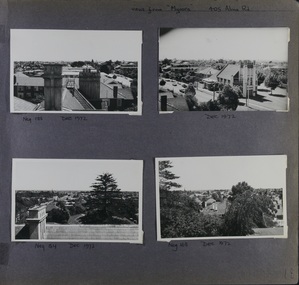 Glen Eira Historical Society
Album - Album page, Myoora, 405 Alma Road, Circa 1972
... Caulfield Historical Society to assist in identifying buildings worthy of preservation. The album is related to a Survey the Caulfield Historical Society developed in collaboration with the National Trust of Australia (Victoria) and Caulfield City Council to identify historic buildings within the City of Caulfield that warranted the protection of a National Trust Classification. Principal photographer thought to be Trevor Hart, member of Caulfield Historical Society. Most photographs were taken between 1966-1972 with a small number of photographs being older and from unknown sources. All photographs are black and white except where stated, with 386 photographs over 198 pages. Victorian Heritage ...This photograph is part of the Caulfield Historical Album 1972. This album was created in approximately 1972 as part of a project by the Caulfield Historical Society to assist in identifying buildings worthy of preservation. The album is related to a Survey the Caulfield Historical Society developed in collaboration with the National Trust of Australia (Victoria) and Caulfield City Council to identify historic buildings within the City of Caulfield that warranted the protection of a National Trust Classification. Principal photographer thought to be Trevor Hart, member of Caulfield Historical Society. Most photographs were taken between 1966-1972 with a small number of photographs being older and from unknown sources. All photographs are black and white except where stated, with 386 photographs over 198 pages.Victorian Heritage Register (VHR) Number H0490 From the Victorian Heritage Register Database - Citation for Myoora https://vhd.heritagecouncil.vic.gov.au/places/275 (as at 6/10/2020) Myoora, 405 Alma Road, North Caulfield, was designed by Reed, Henderson & Smart and can be attributed to Anketell Henderson. It was built in 1886 and 1887 for Thomas Christian, who had founded the fabled gold mine, the Day Dawn at Charters Towers. He never occupied the house although his widow lived there for some time. The house was subdivided into three and later six flats. Myoora was one of many large mansions on broad acres with gardens in Caulfield. Perhaps the grandest was Labassa. The mansions date from the 1850s through to the late 1890s. The siting of Myoora on a ridge influenced its planning and composition. A central hall and corridor along the ridge is entered from the centre of the more formal north facade. The entrance is marked by an elaborately detailed tower. A stair turret provides a second accent. The western end of the building is completed by a massively detailed chimney as the service wing. The south facade enjoyed an outlook to port phillip from a two-storey cast iron verandah. Bay windows, chimneys, the tower and the turret and minor details are brought together in a sophisticated asymmetrical composition. This is reflected in the planning. The asymmetry of Myoora pivoting on the tower is the most notable feature of the building. The walls are built of cement rendered brick. The cement render has not been painted. The roof is slate. The balconies and verandah are cast iron. The footings and cellar are bluestone. The architectural firm Reed, Henderson & Smart was very prominent in Victoria in the nineteenth century. Anketell Henderson was an eminent and well respected member of the profession. He worked successfully in London and interstate as well as in Victoria. They were better known for commercial and public buildings. Myoora is an important private commission. The style of Myoora is a combination of details from the Continental and English Renaissance through the boom style and the Queen Anne style. There is also an early influence from the American Romanesque style especially in the stair turret. The latter style was important at the turn of the century and Myoora is a significant precursor. Other buildings of a similar scale survive in Caulfield and elsewhere. Labassa, the most fabulous, is quite different stylistically as are most of the other comparable mansions. Stonnington is perhaps closer but relies on different details from the Queen Anne style and lacks any American influence. For its historical associations through its owners and architects, for its style and composition and for its intactness, Myoora is significant at a State level. The craftmanship of Myoora is what could be expected of a building of the time and type. It is relatively intact and in fair condition. The main staircase has been removed, minor alterations to decorative features have occurred and additions have been made to the exterior.Page 18 of Photograph Album including four black and white photographs. All are arranged in landscape orientation with two on the top half of the page and the other two below.Handwritten: views from "Myoora" 405 Alma Road / [top right hand] / Neg 188 Dec 1972 [under top left photo] / Dec 1972 [under top right photo] / Neg 184 Dec 1972 [under bottom left photo] / Neg 168 Dec 1972 [under bottom right photo] / 18 [bottom right]caulfield north, trevor hart, alma road, mansion, myoora, tower, thomas christian, 1880's, queen anne, turret, cement rendered brick, unpainted, balconies, verandahs, anketell henderson, continental and english renaissance, american romanesque, cast iron balconies, panoramic views, streetscapes, cast iron work, reed henderson & smart, asymmetrical style, gardens, slate roofs -
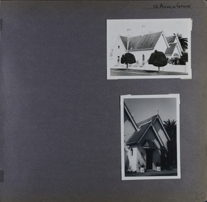 Glen Eira Historical Society
Album - Album page, Avoca Grove, 12, Circa 1972
... buildings worthy of preservation. The album is related to a Survey the Caulfield Historical Society developed in collaboration with the National Trust of Australia (Victoria) and Caulfield City Council to identify historic buildings within the City of Caulfield that warranted the protection of a National Trust Classification. Principal photographer thought to be Trevor Hart, member of Caulfield Historical Society. Most photographs were taken between 1966-1972 with a small number of photographs being older and from unknown sources. All photographs are black and white except where stated, with 386 photographs over 198 pages. From Glen Eira Heritage ...This photograph is part of the Caulfield Historical Album 1972. This album was created in approximately 1972 as part of a project by the Caulfield Historical Society to assist in identifying buildings worthy of preservation. The album is related to a Survey the Caulfield Historical Society developed in collaboration with the National Trust of Australia (Victoria) and Caulfield City Council to identify historic buildings within the City of Caulfield that warranted the protection of a National Trust Classification. Principal photographer thought to be Trevor Hart, member of Caulfield Historical Society. Most photographs were taken between 1966-1972 with a small number of photographs being older and from unknown sources. All photographs are black and white except where stated, with 386 photographs over 198 pages.From Glen Eira Heritage Management Plan (1996) by Andrew Ward and Associates: The house at 12 Avoca Grove, part of "Merton", now demolished, is understood to have been built for and occupied by James Wilberforce Stephens from c.1865. It has aesthetic and historical significance. The building's aesthetic value is derived from the manner in which it demonstrates aspects of the Cottage Orne style, popular among Melboume's gentry during the mid Victorian period. Its historical value is derived from its association with J. W. Stephens, MLA, for East St Kilda and a prominent Caulfield resident.Page 20 of Photograph Album - two black and white exterior photographs of a house with both photographs on the right hand side of the page, the top in landscape mode and the bottom portrait. Hand written: 12 Avoca Grove [top right of page] / 20 [bottom right]trevor hart, avoca grove, church, caulfield north, merton, james wilberforce stephens, cottage orne style, j w stephens (mla)
