Showing 438 items matching " crown lands"
-
 Bendigo Historical Society Inc.
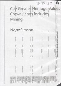
Document - CITY GREATER HERITAGE VALUES CROWN LANDS INCLUDES MINING
... CITY GREATER HERITAGE VALUES CROWN LANDS INCLUDES MINING...Crown lands...City Greater Heritage Values Crown Lands Includes Mining...Crown lands Bendigo Heritage DVD. City Greater Heritage Values Crown Lands Includes Mining Document CITY GREATER HERITAGE VALUES CROWN LANDS INCLUDES MINING ...DVD. City Greater Heritage Values Crown Lands Includes Miningcrown lands, bendigo heritage -
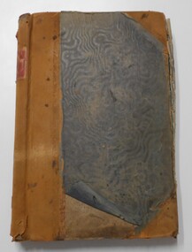
 Federation University Historical Collection
Document, Crown Lands Alienated , 1861, 1861
... Crown Lands Alienated , 1861...crown lands...Blue Foolscap printed Government document relating to alienated Crown Lands. ...Barker Library (top floor) Mount Helen goldfields crown lands Blue Foolscap printed Government document relating to alienated Crown Lands. ...Blue Foolscap printed Government document relating to alienated Crown Lands. crown lands -
Lakes Entrance Historical Society
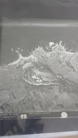
Map - Colquhoun Crown Lands Survey 8422-2-1 Zone 55
... Colquhoun Crown Lands Survey 8422-2-1 Zone 55......Crown Lands...Colquhoun Department of Crown Lands and Survey 8422-2-1 Zone 55 map...Lakes Entrance Historical Society 4 Marine Parade Lakes Entrance gippsland Forest Crown Lands Surveying Colquhoun Department of Crown Lands and Survey 8422-2-1 Zone 55 map Map Colquhoun Crown Lands Survey 8422-2-1 Zone 55 ...Colquhoun Department of Crown Lands and Survey 8422-2-1 Zone 55 mapforest, crown lands, surveying -
 Peterborough History Group
Photograph - Aerial Photograph Peterborough, Department of Crown Lands & Survey, Jan 1971
... ...Department of Crown Lands...Stamped Dept of Crown Lands & Survey...Department of Crown Lands & Survey...Peterborough History Group Peterborough great-ocean-road Aerial photograph showing the past layout of the town Significant in that it shows the town as it was in 1971. peterborough 3270 curdies estuary bay of islands crown land photograph aerial photograph Department of Crown Lands Stamped Dept of Crown Lands & Survey Square 9" x 9" aerial photograph x 4 - (2 photos in duplicate) Photograph Aerial Photograph Peterborough Department of Crown Lands & Survey ...Aerial photograph showing the past layout of the townSignificant in that it shows the town as it was in 1971.Square 9" x 9" aerial photograph x 4 - (2 photos in duplicate)Stamped Dept of Crown Lands & Surveypeterborough 3270, curdies estuary, bay of islands, crown land photograph, aerial photograph, department of crown lands -
 Bendigo Historical Society Inc.
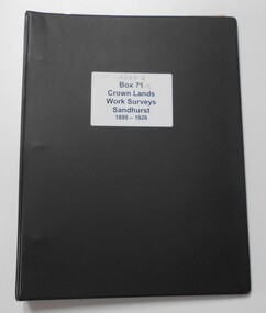
Photograph - CROWN LANDS WORK SURVEYS 1895 - 1926
... CROWN LANDS WORK SURVEYS 1895 - 1926...... Crown Lands Work Survey...Black folder contains 14 buff coloured foolscap booklets in individual plastic pockets, listing crown lands work surveys in Bendigo. Pages are handwritten....Pages are handwritten. Photograph CROWN LANDS WORK SURVEYS 1895 - 1926 ...Black folder contains 14 buff coloured foolscap booklets in individual plastic pockets, listing crown lands work surveys in Bendigo. Pages are handwritten.hospital, bendigo, crown lands work survey, surveying, land -
Federation University Historical Collection
Document, Crown Lands in Villiers and Westward Counties, 1856-7, 1856-7
... Crown Lands in Villiers and Westward Counties, 1856-7......crown lands...Blue foolscap printed Government document lon Crown lands in Villiers and Westward Counties. ...Barker Library (top floor) Mount Helen goldfields land land sales villiers heytesbury hampden normanby dundas follett crown lands Blue foolscap printed Government document lon Crown lands in Villiers and Westward Counties. ...Blue foolscap printed Government document lon Crown lands in Villiers and Westward Counties. It inlcudes the return shoiung number of acres of land sold and the amount received for same. land, land sales, villiers, heytesbury, hampden, normanby, dundas, follett, crown lands -
 Bayside Gallery - Bayside City Council Art & Heritage Collection
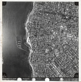
Photograph, Department of Crown Lands and Survey, Victoria, Melbourne Project: Brighton, 1976
... ...Department of Crown Lands and Survey...The Department of Crown Lands and Survey (1857-1983) was responsible for the administration of survey and mapping and the sale, occupation and management of crown land throughout its existence. ...Department of Crown Lands and Survey, Victoria...Melbourne Project: Brighton Photograph photograph Department of Crown Lands and Survey, Victoria ...The Department of Crown Lands and Survey (1857-1983) was responsible for the administration of survey and mapping and the sale, occupation and management of crown land throughout its existence. This aerial photograph shows parts of Brighton and was taken on 1 December 1976brighton, department of crown lands and survey, aerial photograph, bayside, port phillip bay, map, cartographic material, melbourne project 1976, brighton yacht club, middle brighton baths, north road, st kilda street, new street -
 Bayside Gallery - Bayside City Council Art & Heritage Collection
Photograph, Department of Crown Lands and Survey, Victoria, Melbourne Project: Brighton and Elwood, 1976
... ...Department of Crown Lands and Survey...The Department of Crown Lands and Survey (1857-1983) was responsible for the administration of survey and mapping and the sale, occupation and management of crown land throughout its existence. ...Department of Crown Lands and Survey, Victoria...Melbourne Project: Brighton and Elwood Photograph photograph Department of Crown Lands and Survey, Victoria ...The Department of Crown Lands and Survey (1857-1983) was responsible for the administration of survey and mapping and the sale, occupation and management of crown land throughout its existence. This aerial photograph shows parts of Brighton and Elwood and was taken on 1 December 1976brighton, elwood, department of crown lands and survey, aerial photograph, elsternwick park, point ormond, north road, ormond esplanade, st kilda street, glen huntly road, bayside, port phillip bay, map, cartographic material, melbourne project 1976 -
 Bayside Gallery - Bayside City Council Art & Heritage Collection
Photograph, Department of Crown Lands and Survey, Victoria, Melbourne Project: Brighton and Hampton, 1976
... ...Department of Crown Lands and Survey...The Department of Crown Lands and Survey (1857-1983) was responsible for the administration of survey and mapping and the sale, occupation and management of crown land throughout its existence. ...Department of Crown Lands and Survey, Victoria...Melbourne Project: Brighton and Hampton Photograph photograph Department of Crown Lands and Survey, Victoria ...The Department of Crown Lands and Survey (1857-1983) was responsible for the administration of survey and mapping and the sale, occupation and management of crown land throughout its existence. This aerial photograph shows parts of Brighton and Hampton and was taken on 1 December 1976. brighton, department of crown lands and survey, aerial photograph, bayside, port phillip bay, map, cartographic material, melbourne project 1976, brighton yacht club, middle brighton baths, hampton, green point, brighton beach, south road, the esplanade, hampton street -
 Bayside Gallery - Bayside City Council Art & Heritage Collection
Photograph, Department of Crown Lands and Survey, Victoria, Melbourne Project: Brighton, Hampton, Sandringham, 1976
... ...Department of Crown Lands and Survey...The Department of Crown Lands and Survey (1857-1983) was responsible for the administration of survey and mapping and the sale, occupation and management of crown land throughout its existence. ...Department of Crown Lands and Survey, Victoria...Melbourne Project: Brighton, Hampton, Sandringham Photograph photograph Department of Crown Lands and Survey, Victoria ...The Department of Crown Lands and Survey (1857-1983) was responsible for the administration of survey and mapping and the sale, occupation and management of crown land throughout its existence. This aerial photograph shows parts of Brighton, Hampton and Sandringham and was taken on 1 December 1976brighton, department of crown lands and survey, aerial photograph, bayside, port phillip bay, map, cartographic material, hampton, sandringham, green point, sandringham yacht club, south road, beach road, hampton street, melbourne project 1976 -
 Bayside Gallery - Bayside City Council Art & Heritage Collection
Photograph, Department of Crown Lands and Survey, Victoria, Brighton, Elwood and Elsternwick, c. 1965-71
... ...Department of Crown Lands and Survey...The Department of Crown Lands and Survey (1857-1983) was responsible for the administration of survey and mapping and the sale, occupation and management of crown land throughout its existence. ...Department of Crown Lands and Survey, Victoria...Brighton, Elwood and Elsternwick Photograph photograph Department of Crown Lands and Survey, Victoria ...The Department of Crown Lands and Survey (1857-1983) was responsible for the administration of survey and mapping and the sale, occupation and management of crown land throughout its existence. This aerial photograph shows parts of Brighton, Elwood and Elsternwick and was taken circa 1965-71.brighton, department of crown lands and survey, aerial photograph, bayside, port phillip bay, map, cartographic material, elwood, elsternwick, elsternwick park, elwood tram depot, elwood pier, new street, glen huntly road, st kilda street, nepean highway -
 Bayside Gallery - Bayside City Council Art & Heritage Collection
Photograph, Department of Crown Lands and Survey, Victoria, Brighton, Brighton East and Bentleigh, c. 1965-71
... ...Department of Crown Lands and Survey...The Department of Crown Lands and Survey (1857-1983) was responsible for the administration of survey and mapping and the sale, occupation and management of crown land throughout its existence. ...Department of Crown Lands and Survey, Victoria...Brighton, Brighton East and Bentleigh Photograph photograph Department of Crown Lands and Survey, Victoria ...The Department of Crown Lands and Survey (1857-1983) was responsible for the administration of survey and mapping and the sale, occupation and management of crown land throughout its existence. This aerial photograph shows parts of Brighton and Brighton East and was taken circa 1965-71.brighton, department of crown lands and survey, aerial photograph, bayside, port phillip bay, map, cartographic material, brighton east, dendy park, dendy street, centre road, nepean highway, south road, brighton golf course, golf -
 Bayside Gallery - Bayside City Council Art & Heritage Collection
Photograph, Department of Crown Lands and Survey, Victoria, Brighton, Brighton East and Bentleigh, c. 1965-71
... ...Department of Crown Lands and Survey...The Department of Crown Lands and Survey (1857-1983) was responsible for the administration of survey and mapping and the sale, occupation and management of crown land throughout its existence. ...Department of Crown Lands and Survey, Victoria...Brighton, Brighton East and Bentleigh Photograph photograph Department of Crown Lands and Survey, Victoria ...The Department of Crown Lands and Survey (1857-1983) was responsible for the administration of survey and mapping and the sale, occupation and management of crown land throughout its existence. This aerial photograph shows parts of Brighton, Brighton East and Bentleigh and was taken circa 1965-71.brighton, department of crown lands and survey, aerial photograph, bayside, port phillip bay, map, cartographic material, bentleigh, brighton east, dendy park, dendy street, centre road, nepean highway, south road, football -
 Bendigo Historical Society Inc.
Document - LANDS OFFICE: SALE OF CROWN LANDS BY PUBLIC AUCTION, 25/5/1898 - 26/8/1915
... LANDS OFFICE: SALE OF CROWN LANDS BY PUBLIC AUCTION...crown lands public auction...History House 11 Mackenzie Street Bendigo goldfields crown lands public auction Lands office crown lands public auction. ...Journal: green hard cover journal with brown spine and corners. LH page: lot, county, town or parish, section, allotment, extent, why not sold, upset price per acre, sold for per acre. RH page: value of improvements, name of purchaser, residence, deposit forfeited, total amount. Contains details of sales by public auction across Victoria.Lands Officecrown lands public auction, lands office, crown lands, public auction., sandhurst -
Port Melbourne Historical & Preservation Society
Document - Notice, Auction, Crown Lands, 1892
... Notice, Auction, Crown Lands...Auction notice of Crown lands, 1892...Port Melbourne Historical & Preservation Society Port Melbourne Town Hall 333 Bay Street Port Melbourne melbourne town planning land sales Auction notice of Crown lands, 1892 Document Notice, Auction, Crown Lands Victorian Government Government Printer ...Auction notice of Crown lands, 1892town planning, land sales -
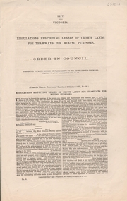 Bendigo Historical Society Inc.
Document - LEASES OF CROWN LANDS FOR TRAMWAYS FOR MINING PURPOSES, 1877
... LEASES OF CROWN LANDS FOR TRAMWAYS FOR MINING PURPOSES...LEASES OF CROWN LANDS FOR TRAMWAYS FOR MINING PURPOSES...History House 11 Mackenzie Street Bendigo goldfields GOVERNMENT State Mines Act gold mining tramways crown land LEASES OF CROWN LANDS FOR TRAMWAYS FOR MINING PURPOSES Document LEASES OF CROWN LANDS FOR TRAMWAYS FOR MINING PURPOSES ...LEASES OF CROWN LANDS FOR TRAMWAYS FOR MINING PURPOSESgovernment, state, mines act, gold mining, tramways, crown land -
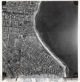
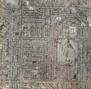
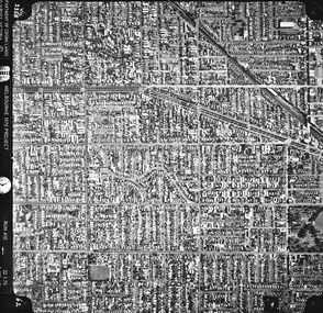 St Kilda Historical Society
Photograph - Photo map, Department of Crown Lands and Survey (1857-1983), 22/01/1970
... One of a series of photo-maps produced for the Department of Crown Lands and Survey (1857-1983). For correlation with a current map, and access to other historical photo maps of Victoria, see the Historic Photo-Maps Index published by the Department of Environment, Land, Water and Planning at https://services.land.vic.gov.au/DELWPmaps/historical-photomaps/...Vic 2358 Department of Crown Lands and Survey Victoria,.© Melbourne 1970 Project Run 41E 22.1.70 5,100 ASL 62...Department of Crown Lands and Survey (1857-1983)...St Kilda Historical Society St Kilda Branch Library 150 Carlisle Street St Kilda melbourne One of a series of photo-maps produced for the Department of Crown Lands and Survey (1857-1983). For correlation with a current map, and access to other historical photo maps of Victoria, see the Historic Photo-Maps Index published by the Department of Environment, Land, Water and Planning at https://services.land.vic.gov.au/DELWPmaps/historical-photomaps/ Caulfield Caulfield North St Kilda EAst Armadale 1970 Vic 2358 Department of Crown Lands and Survey Victoria,.© Melbourne 1970 Project Run 41E 22.1.70 5,100 ASL 62 Black and white aerial photograph Photograph Photo map Department of Crown Lands and Survey (1857-1983) ...One of a series of photo-maps produced for the Department of Crown Lands and Survey (1857-1983). For correlation with a current map, and access to other historical photo maps of Victoria, see the Historic Photo-Maps Index published by the Department of Environment, Land, Water and Planning at https://services.land.vic.gov.au/DELWPmaps/historical-photomaps/Black and white aerial photographVic 2358 Department of Crown Lands and Survey Victoria,.© Melbourne 1970 Project Run 41E 22.1.70 5,100 ASL 62caulfield, caulfield north, st kilda east, armadale, 1970 -
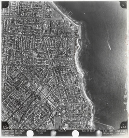
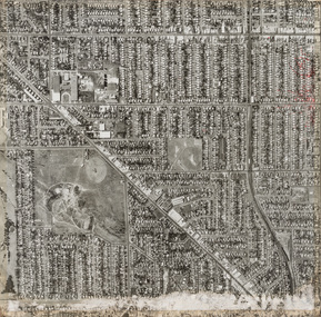
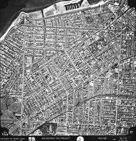 St Kilda Historical Society
Photograph - Photo map, Department of Crown Lands and Survey (1857-1983), 22/01/1970
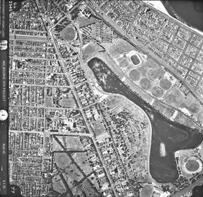
... One of a series of photo-maps produced for the Department of Crown Lands and Survey (1857-1983). For correlation with a current map, and access to other historical photo maps of Victoria, see the Historic Photo-Maps Index published by the Department of Environment, Land, Water and Planning at https://services.land.vic.gov.au/DELWPmaps/historical-photomaps/...Vic 2358 Department of Crown Lands and Survey Victoria,.© Melbourne 1970 Project Run 42E 22.1.70 5,100 ASL 77...Department of Crown Lands and Survey (1857-1983)...St Kilda Historical Society St Kilda Branch Library 150 Carlisle Street St Kilda melbourne One of a series of photo-maps produced for the Department of Crown Lands and Survey (1857-1983). For correlation with a current map, and access to other historical photo maps of Victoria, see the Historic Photo-Maps Index published by the Department of Environment, Land, Water and Planning at https://services.land.vic.gov.au/DELWPmaps/historical-photomaps/ St Kilda St Kilda East St Kilda Marina Elwood Elwood canal Elsternwick Park Point Ormond Balaclava MC Moran Reserve Ripponlea St Kilda Botanical Gardens Peanut farm 1970 Vic 2358 Department of Crown Lands and Survey Victoria,.© Melbourne 1970 Project Run 42E 22.1.70 5,100 ASL 77 Black and white aerial photograph Photograph Photo map Department of Crown Lands and Survey (1857-1983) ...One of a series of photo-maps produced for the Department of Crown Lands and Survey (1857-1983). For correlation with a current map, and access to other historical photo maps of Victoria, see the Historic Photo-Maps Index published by the Department of Environment, Land, Water and Planning at https://services.land.vic.gov.au/DELWPmaps/historical-photomaps/Black and white aerial photographVic 2358 Department of Crown Lands and Survey Victoria,.© Melbourne 1970 Project Run 42E 22.1.70 5,100 ASL 77st kilda, st kilda east, st kilda marina, elwood, elwood canal, elsternwick park, point ormond, balaclava, mc moran reserve, ripponlea, st kilda botanical gardens, peanut farm, 1970 -
 St Kilda Historical Society
Photograph - Photo map, Department of Crown Lands and Survey, 22/01/1970
... One of a series of photo-maps produced for the Department of Crown Lands and Survey (1857-1983). For correlation with a current map, and access to other historical photo maps of Victoria, see the Historic Photo-Maps Index published by the Department of Environment, Land, Water and Planning at https://services.land.vic.gov.au/DELWPmaps/historical-photomaps/...Vic 2358 Department of Crown Lands and Survey Victoria,.© Melbourne 1970 Project Run 43E 22.1.70 5,100 ASL 208...Department of Crown Lands and Survey ...St Kilda Historical Society St Kilda Branch Library 150 Carlisle Street St Kilda melbourne One of a series of photo-maps produced for the Department of Crown Lands and Survey (1857-1983). For correlation with a current map, and access to other historical photo maps of Victoria, see the Historic Photo-Maps Index published by the Department of Environment, Land, Water and Planning at https://services.land.vic.gov.au/DELWPmaps/historical-photomaps/ Elwood Elwood beach Point Ormond Elwood Park Elwood canal MC Moran Reserve 1970 Vic 2358 Department of Crown Lands and Survey Victoria,.© Melbourne 1970 Project Run 43E 22.1.70 5,100 ASL 208 Black and white aerial photograph Photograph Photo map Department of Crown Lands and Survey ...One of a series of photo-maps produced for the Department of Crown Lands and Survey (1857-1983). For correlation with a current map, and access to other historical photo maps of Victoria, see the Historic Photo-Maps Index published by the Department of Environment, Land, Water and Planning at https://services.land.vic.gov.au/DELWPmaps/historical-photomaps/Black and white aerial photographVic 2358 Department of Crown Lands and Survey Victoria,.© Melbourne 1970 Project Run 43E 22.1.70 5,100 ASL 208elwood, elwood beach, point ormond, elwood park, elwood canal, mc moran reserve, 1970 -
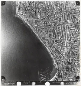
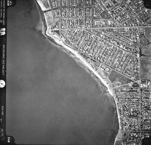
 St Kilda Historical Society
Photograph - Photo map, Department of Crown Lands and Survey, 22/01/1970
... One of a series of photo-maps produced for the Department of Crown Lands and Survey (1857-1983). For correlation with a current map, and access to other historical photo maps of Victoria, see the Historic Photo-Maps Index published by the Department of Environment, Land, Water and Planning at https://services.land.vic.gov.au/DELWPmaps/historical-photomaps/...Vic 2358 Department of Crown Lands and Survey Victoria,.© Melbourne 1970 Project Run 42E 22.1.70 5,100 ASL 75...Department of Crown Lands and Survey ...St Kilda Historical Society St Kilda Branch Library 150 Carlisle Street St Kilda melbourne One of a series of photo-maps produced for the Department of Crown Lands and Survey (1857-1983). For correlation with a current map, and access to other historical photo maps of Victoria, see the Historic Photo-Maps Index published by the Department of Environment, Land, Water and Planning at https://services.land.vic.gov.au/DELWPmaps/historical-photomaps/ St Kilda St Kilda beach St Kilda marina Point Ormond St Kilda pier 1970 Vic 2358 Department of Crown Lands and Survey Victoria,.© Melbourne 1970 Project Run 42E 22.1.70 5,100 ASL 75 Black and white aerial photograph Photograph Photo map Department of Crown Lands and Survey ...One of a series of photo-maps produced for the Department of Crown Lands and Survey (1857-1983). For correlation with a current map, and access to other historical photo maps of Victoria, see the Historic Photo-Maps Index published by the Department of Environment, Land, Water and Planning at https://services.land.vic.gov.au/DELWPmaps/historical-photomaps/Black and white aerial photographVic 2358 Department of Crown Lands and Survey Victoria,.© Melbourne 1970 Project Run 42E 22.1.70 5,100 ASL 75st kilda, st kilda beach, st kilda marina, point ormond, st kilda pier, 1970 -
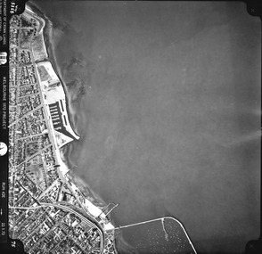
 St Kilda Historical Society
Photograph - Photo map, Department of Crown Lands and Survey, 22/01/1970
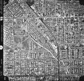
... One of a series of photo-maps produced for the Department of Crown Lands and Survey (1857-1983). For correlation with a current map, and access to other historical photo maps of Victoria, see the Historic Photo-Maps Index published by the Department of Environment, Land, Water and Planning at https://services.land.vic.gov.au/DELWPmaps/historical-photomaps/...Vic 2358 Department of Crown Lands and Survey Victoria,.© Melbourne 1970 Project Run 41E 22.1.70 5,100 ASL 64...Department of Crown Lands and Survey ...St Kilda Historical Society St Kilda Branch Library 150 Carlisle Street St Kilda melbourne One of a series of photo-maps produced for the Department of Crown Lands and Survey (1857-1983). For correlation with a current map, and access to other historical photo maps of Victoria, see the Historic Photo-Maps Index published by the Department of Environment, Land, Water and Planning at https://services.land.vic.gov.au/DELWPmaps/historical-photomaps/ St Kilda St Kilda cemetery Balaclava St Kilda East Windsor Caulfield North Alma Park 1970 Vic 2358 Department of Crown Lands and Survey Victoria,.© Melbourne 1970 Project Run 41E 22.1.70 5,100 ASL 64 Black and white aerial photograph Photograph Photo map Department of Crown Lands and Survey ...One of a series of photo-maps produced for the Department of Crown Lands and Survey (1857-1983). For correlation with a current map, and access to other historical photo maps of Victoria, see the Historic Photo-Maps Index published by the Department of Environment, Land, Water and Planning at https://services.land.vic.gov.au/DELWPmaps/historical-photomaps/Black and white aerial photographVic 2358 Department of Crown Lands and Survey Victoria,.© Melbourne 1970 Project Run 41E 22.1.70 5,100 ASL 64st kilda, st kilda cemetery, balaclava, st kilda east, windsor, caulfield north, alma park, 1970 -
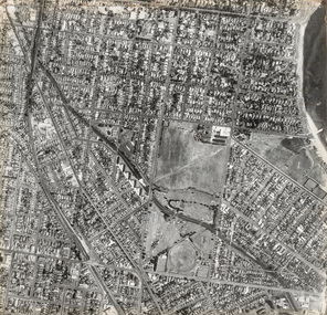
 St Kilda Historical Society
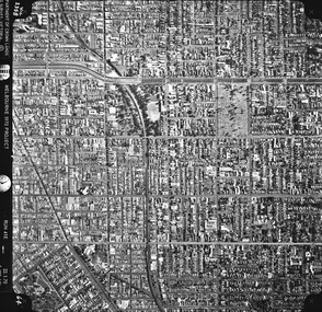
Photograph - Photo map, Department of Crown Lands and Survey, 08/01/1970
... One of a series of photo-maps produced for the Department of Crown Lands and Survey (1857-1983). For correlation with a current map, and access to other historical photo maps of Victoria, see the Historic Photo-Maps Index published by the Department of Environment, Land, Water and Planning at https://services.land.vic.gov.au/DELWPmaps/historical-photomaps/...Vic 2345 Department of Crown Lands and Survey Victoria,.© Melbourne 1970 Project Run 40 8.1.70 5,100 ASL 77...Department of Crown Lands and Survey ...St Kilda Historical Society St Kilda Branch Library 150 Carlisle Street St Kilda melbourne One of a series of photo-maps produced for the Department of Crown Lands and Survey (1857-1983). For correlation with a current map, and access to other historical photo maps of Victoria, see the Historic Photo-Maps Index published by the Department of Environment, Land, Water and Planning at https://services.land.vic.gov.au/DELWPmaps/historical-photomaps/ Albert Park Fawkner Park South Yarra Middle Park Prahran Windsor St Kilda St Kilda West 1970 Vic 2345 Department of Crown Lands and Survey Victoria,.© Melbourne 1970 Project Run 40 8.1.70 5,100 ASL 77 Black and white arial photograph Photograph Photo map Department of Crown Lands and Survey ...One of a series of photo-maps produced for the Department of Crown Lands and Survey (1857-1983). For correlation with a current map, and access to other historical photo maps of Victoria, see the Historic Photo-Maps Index published by the Department of Environment, Land, Water and Planning at https://services.land.vic.gov.au/DELWPmaps/historical-photomaps/Black and white arial photographVic 2345 Department of Crown Lands and Survey Victoria,.© Melbourne 1970 Project Run 40 8.1.70 5,100 ASL 77albert park, fawkner park, south yarra, middle park, prahran, windsor, st kilda, st kilda west, 1970 -
 St Kilda Historical Society
Photograph - Photo map, 22/01/1970
... One of a series of photo-maps produced for the Department of Crown Lands and Survey (1857-1983). For correlation with a current map, and access to other historical photo maps of Victoria, see the Historic Photo-Maps Index published by the Department of Environment, Land, Water and Planning at https://services.land.vic.gov.au/DELWPmaps/historical-photomaps/...Vic 2358 Department of Crown Lands and Survey Victoria,.© Melbourne 1970 Project Run 43E 22.1.70 5,100 ASL 206...Department of Crown Lands and Survey ...St Kilda Historical Society St Kilda Branch Library 150 Carlisle Street St Kilda melbourne One of a series of photo-maps produced for the Department of Crown Lands and Survey (1857-1983). For correlation with a current map, and access to other historical photo maps of Victoria, see the Historic Photo-Maps Index published by the Department of Environment, Land, Water and Planning at https://services.land.vic.gov.au/DELWPmaps/historical-photomaps/ Elwood Elsternwick Elsternwick Park 1970 Vic 2358 Department of Crown Lands and Survey Victoria,.© Melbourne 1970 Project Run 43E 22.1.70 5,100 ASL 206 Black and white aerial photograph Photograph Photo map Department of Crown Lands and Survey ...One of a series of photo-maps produced for the Department of Crown Lands and Survey (1857-1983). For correlation with a current map, and access to other historical photo maps of Victoria, see the Historic Photo-Maps Index published by the Department of Environment, Land, Water and Planning at https://services.land.vic.gov.au/DELWPmaps/historical-photomaps/Black and white aerial photographVic 2358 Department of Crown Lands and Survey Victoria,.© Melbourne 1970 Project Run 43E 22.1.70 5,100 ASL 206elwood, elsternwick, elsternwick park, 1970 -
 St Kilda Historical Society
Photograph - Photo map, Department of Crown Lands and Survey, 22/01/1970
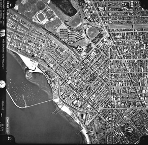
... One of a series of photo-maps produced for the Department of Crown Lands and Survey (1857-1983). For correlation with a current map, and access to other historical photo maps of Victoria, see the Historic Photo-Maps Index published by the Department of Environment, Land, Water and Planning at https://services.land.vic.gov.au/DELWPmaps/historical-photomaps/...CONTROLLED Vic 2358 Department of Crown Lands and Survey Victoria,.© Melbourne 1970 Project Run 41E 22.1.70 5,100 ASL 66...Department of Crown Lands and Survey ...St Kilda Historical Society St Kilda Branch Library 150 Carlisle Street St Kilda melbourne One of a series of photo-maps produced for the Department of Crown Lands and Survey (1857-1983). For correlation with a current map, and access to other historical photo maps of Victoria, see the Historic Photo-Maps Index published by the Department of Environment, Land, Water and Planning at https://services.land.vic.gov.au/DELWPmaps/historical-photomaps/ St Kilda Albert Park St Kilda West Catani Gardens St Kilda Botanical Gardens St Kilda pier St Kilda beach 1970 CONTROLLED Vic 2358 Department of Crown Lands and Survey Victoria,.© Melbourne 1970 Project Run 41E 22.1.70 5,100 ASL 66 Black and white aerial photograph Photograph Photo map Department of Crown Lands and Survey ...One of a series of photo-maps produced for the Department of Crown Lands and Survey (1857-1983). For correlation with a current map, and access to other historical photo maps of Victoria, see the Historic Photo-Maps Index published by the Department of Environment, Land, Water and Planning at https://services.land.vic.gov.au/DELWPmaps/historical-photomaps/Black and white aerial photographCONTROLLED Vic 2358 Department of Crown Lands and Survey Victoria,.© Melbourne 1970 Project Run 41E 22.1.70 5,100 ASL 66st kilda, albert park, st kilda west, catani gardens, st kilda botanical gardens, st kilda pier, st kilda beach, 1970 -
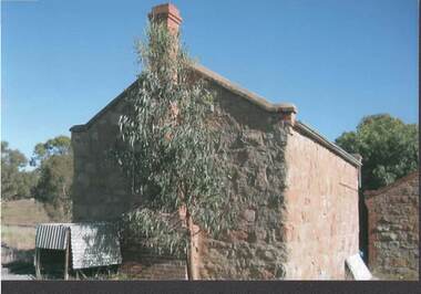 Bendigo Historical Society Inc.
Photograph - RAVENSWOOD CROWN LANDS
... RAVENSWOOD CROWN LANDS...colour Photograph, Ravenswood Crown Lands, Another stone building ....History House 11 Mackenzie Street Bendigo goldfields PHOTOGRAPH Building ravenswood estate colour Photograph, Ravenswood Crown Lands, Another stone building . Photograph RAVENSWOOD CROWN LANDS ...colour Photograph, Ravenswood Crown Lands, Another stone building .photograph, building, ravenswood estate -
 Bendigo Historical Society Inc.
Document - LANDS OFFICE - CROWN LANDS SURVEYED AND SOLD - INDEX, 26.1.1857 - 1871
... LANDS OFFICE - CROWN LANDS SURVEYED AND SOLD - INDEX...... crown lands sold...Document LANDS OFFICE - CROWN LANDS SURVEYED AND SOLD - INDEX ...Document: hard cover journal, faded dark green cover with brown corners and spine. 193 pages filled out - LH page: Parish, town lands, suburban lands, country lands, total lands surveyed, date of survey RH page: date of sale, by auction, by selection, price per acre, total amount, name of purchaser. On spine ' 01, index book O'.Lands Officelands office, bendigo, sandhurst, crown lands sold, rural land. -
Federation University Historical Collection
Document, Crown Lands Act, 1862, 1862
... Crown Lands Act, 1862...Blue foolscap printed Government document on the Crown Lands Act. ...Barker Library (top floor) Mount Helen goldfields land land sales crown land ararat petition Blue foolscap printed Government document on the Crown Lands Act. Crown Lands Act, 1862 Document John Ferres John Ferres ...Blue foolscap printed Government document on the Crown Lands Act. land, land sales, crown land, ararat, petition -
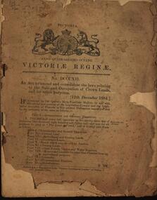 Federation University Historical Collection
Booklet, An Act to amend and consolidate the laws relating to the Sale and Occupation of Crown Lands and for other purposes, 1884, 1884
... An Act to amend and consolidate the laws relating to the Sale and Occupation of Crown Lands and for other purposes, 1884......occupation of crown lands...An Act to amend and consolidate the laws relating to the Sale and Occupation of Crown Lands and for other purposes, 1884 Booklet ...Brown soft covered book of 48 pages. queen victoria, laws, victoria, sale of crown land, occupation of crown lands, selection, land act 1884 -
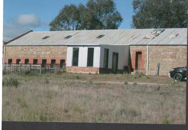 Bendigo Historical Society Inc.
Photograph - RAVENSWOOD CROWN LANDS
... RAVENSWOOD CROWN LANDS...Colour Photograph, Ravenswood Crown Lands, Shearing shed with yards at left....Photograph RAVENSWOOD CROWN LANDS ...Colour Photograph, Ravenswood Crown Lands, Shearing shed with yards at left.photograph, building, ravenswood estate -
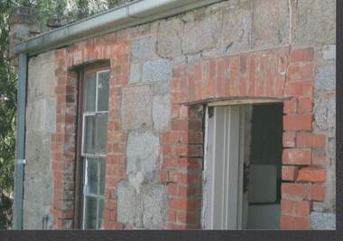 Bendigo Historical Society Inc.
Photograph - RAVENSWOOD CROWN LANDS
... RAVENSWOOD CROWN LANDS...Colour Photograph, Ravenswood Crown Lands, window and doorway at the entrance of a building....Photograph RAVENSWOOD CROWN LANDS ...Colour Photograph, Ravenswood Crown Lands, window and doorway at the entrance of a building.photograph, building, ravenswood estate