Showing 103 items matching " e a webster"
-
 Bendigo Historical Society Inc.
Document - 1913 TO 1914 MASTER BUTCHERS ASSN. OF BENDIGO
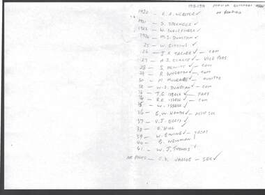
... ... E A Webster...Listed is: 1920 - E A Webster, 1921 - S Sprenger, 1922 - W Inglefinger, 1924 - M S Dunstan, 25 - W Gittins, 26 - J K Tarner - Com, 27 - A J Clarke - Vice Pres, S Hewitt - Com, 29 - R Wheaton - Com, 30 - M Mulcare - Auditor, 32 - W S Dunstan - Com, 33 - T G Issell - Pres, 34 - R E Issell - Com, 35 - W Issell, 36 - E W Hands - Assist Sec, 37 - V J Ellis, 38 - G Hill, 39 - W Ewing - Treasurer, 40 - B Newman, 41 - W J Thomas, No Photo - E K Varcoe - Sec....History House 11 Mackenzie Street Bendigo goldfields BUSINESS Retail butchers 1913 - 1914 Master Butchers Association of Bendigo E A Webster S Sprenger W Inglefinger M S Dunstan W Gittins J K Tarner A J Clarke S Hewitt R Wheaton M Mulcare W S Dunstan T G Issell R E Issell W Issell E W Hands V J Ellis G Hill W Ewing B Newman W J Thomas E K Varcoe Piece of paper headed 1913 - 1914 Master Butchers Assn of Bendigo. ...Piece of paper headed 1913 - 1914 Master Butchers Assn of Bendigo. Listed is: 1920 - E A Webster, 1921 - S Sprenger, 1922 - W Inglefinger, 1924 - M S Dunstan, 25 - W Gittins, 26 - J K Tarner - Com, 27 - A J Clarke - Vice Pres, S Hewitt - Com, 29 - R Wheaton - Com, 30 - M Mulcare - Auditor, 32 - W S Dunstan - Com, 33 - T G Issell - Pres, 34 - R E Issell - Com, 35 - W Issell, 36 - E W Hands - Assist Sec, 37 - V J Ellis, 38 - G Hill, 39 - W Ewing - Treasurer, 40 - B Newman, 41 - W J Thomas, No Photo - E K Varcoe - Sec.business, retail, butchers, 1913 - 1914 master butchers association of bendigo, e a webster, s sprenger, w inglefinger, m s dunstan, w gittins, j k tarner, a j clarke, s hewitt, r wheaton, m mulcare, w s dunstan, t g issell, r e issell, w issell, e w hands, v j ellis, g hill, w ewing, b newman, w j thomas, e k varcoe -
 Bendigo Military Museum
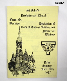
Programme - PROGRAMME, DEDICATION of RATS of TOBRUK, Rats of Tobruk Association, Dedication Service, Memorial Window, St. John's Presbyterian Church, Bendigo
... The rest of the programme has the introduction and the church service by Rev. John E Webster B.A. LTh. Bendigo. 2, The programme is the same but without the coloured photo....The rest of the programme has the introduction and the church service by Rev. John E Webster B.A. LTh. Bendigo. 2, The programme is the same but without the coloured photo. ...The stained glass memorial window was dedicated 12 April 1987. Dean Collection, refer Cat No 4575P1. The programme consists of 4 sheets of A.4 paper, when folded in two forms 16 pages. The cover is a yellow colour. The front cover has an image of St John's Church, the Rats of Tobruk Association logo and the title words. The rear cover has a black and white image of "A Weary Digger" drawn by Ivor Hele. Inside is a coloured photograph (15 x 10 cms) of the memorial window. The rest of the programme has the introduction and the church service by Rev. John E Webster B.A. LTh. Bendigo. 2, The programme is the same but without the coloured photo.ww2, rats of tobruk association -
 Bendigo Historical Society Inc.
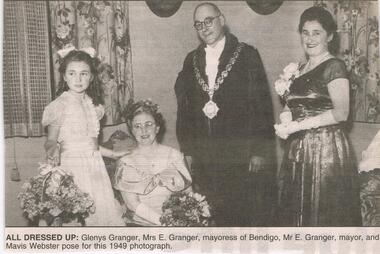
Newspaper - JENNY FOLEY COLLECTION: ALL DRESSED UP
... Granger, mayoress of Bendigo, Mr. E. Granger, mayor and Mavis Webster pose for this 1949 photograph. ...Granger, mayoress of Bendigo, Mr. E. Granger, mayor and Mavis Webster pose for this 1949 photograph. ...BHS CollectionBendigo Advertiser '' the way we were'' from Monday, November 11, 2002. All dressed up: Glenys Granger, Mrs E. Granger, mayoress of Bendigo, Mr. E. Granger, mayor and Mavis Webster pose for this 1949 photograph. The clip is in a folder.newspaper, bendigo advertiser, the way we were -
 Phillip Island and District Historical Society Inc.
Photograph, WWI Soldiers 1919
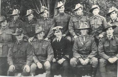
... McColl, Duncan Campbell, Arthur Webster, E. W. Dixon, R. Briton....McColl, Duncan Campbell, Arthur Webster, E. W. Dixon, R. Briton. WWI Soldiers 1919 Photograph ...Photograph of 12 WWI Soldiers and a Naval Officer - all in uniform.Photograph of WWI Soldiers and Naval Officer - 1919 Back Row: W. Gothorp, H. Justice, V. McHenry, Alex McLardy, G. Dorward, W. Hawkins, Unknown, J. Hawkins Front Row: ? McColl, Duncan Campbell, Arthur Webster, E. W. Dixon, R. Briton.wwi soldiers, wwi naval officer, returned soldiers, mary karney -
 Phillip Island and District Historical Society Inc.
Photograph
... McColl, Duncan Campbell, Arthur Webster, E W Dixon, R Briton....McColl, Duncan Campbell, Arthur Webster, E W Dixon, R Briton. Photograph Bryant West ...One of a collection of over 400 photographs in an album commenced in 1960 and presented to the Phillip Island & Westernport Historical Society by the Shire of Phillip IslandPhotograph of Twelve World War I Soldiers and a Naval Officer - all in uniform Back row: W Gothorp, H Justice, V McHenry, Alex McLardy, G Dorward, W McLardy, ????, J Hawkins. Front row: ? McColl, Duncan Campbell, Arthur Webster, E W Dixon, R Briton.local history, photography, phillip island servicemen, black & white photograph, world war i, john jenner, bryant west -
 Federation University Historical Collection
Minute Book, Minute Book 1 of the Eureka Stockade Memorial Park Committee
... E.-G.-Pearce, C.-Jones, W.-Feary, J.-R.-Hams, W.-Pool, W.-Hayes, Rotunda, B.-Dolphin, J.-Elsworth, J.-Elsworth, H.-J.-Ham, J.-Lepp, Ballarat-Fire-Brigade, Ballarat-Pipe-Band, W.-F.-TuckerF.-Micklejohn, athletics, H.-McKinnon, A.-Levy, publican's-booth, Eureka-Carnival, J.-Davies, Ballarat-Lodge, Pathes-Pictures, H.Kisler, J.-Splatt, J.-Ellis, J.-Baxter, J,-Chatham, Our-Own-Little-Rebellion, D.-C.-McGrath, A.-N.-A., O'Dea, Meiklejohn, Eureka-Anniversary, W.-A.-Dalton. Alfred-Pittard, Eureka-Pottery-Works, Railway, Britnell, Easter-Fair, William-Carey, J.-Hill, McIvor, C.-E.-Webster...E.-G.-Pearce, C.-Jones, W.-Feary, J.-R.-Hams, W.-Pool, W.-Hayes, Rotunda, B.-Dolphin, J.-Elsworth, J.-Elsworth, H.-J.-Ham, J.-Lepp, Ballarat-Fire-Brigade, Ballarat-Pipe-Band, W.-F.-TuckerF.-Micklejohn, athletics, H.-McKinnon, A.-Levy, publican's-booth, Eureka-Carnival, J.-Davies, Ballarat-Lodge, Pathes-Pictures, H.Kisler, J.-Splatt, J.-Ellis, J.-Baxter, J,-Chatham, Our-Own-Little-Rebellion, D.-C.-McGrath, A.-N.-A., O'Dea, Meiklejohn, Eureka-Anniversary, W.-A.-Dalton. Alfred-Pittard, Eureka-Pottery-Works, Railway, Britnell, Easter-Fair, William-Carey, J.-Hill, McIvor, C.-E.-Webster ...Brown hard covered book with red tape spine. Handwriiten minutes.F.-Penhalluriack, A.-J.-Pittard, Helen-McKay, D.-Bernardi, Tozer, Gingell, Lugg, R.-McGregor, Eureka-Stockade, J.-S.-Edwards, J.-Davies, J.-S.-Edwards, Eureka-Stockade, Eureka, Eureka-sports, A.-Cant, E.-G.-Pearce, C.-Jones, W.-Feary, J.-R.-Hams, W.-Pool, W.-Hayes, Rotunda, B.-Dolphin, J.-Elsworth, J.-Elsworth, H.-J.-Ham, J.-Lepp, Ballarat-Fire-Brigade, Ballarat-Pipe-Band, W.-F.-TuckerF.-Micklejohn, athletics, H.-McKinnon, A.-Levy, publican's-booth, Eureka-Carnival, J.-Davies, Ballarat-Lodge, Pathes-Pictures, H.Kisler, J.-Splatt, J.-Ellis, J.-Baxter, J,-Chatham, Our-Own-Little-Rebellion, D.-C.-McGrath, A.-N.-A., O'Dea, Meiklejohn, Eureka-Anniversary, W.-A.-Dalton. Alfred-Pittard, Eureka-Pottery-Works, Railway, Britnell, Easter-Fair, William-Carey, J.-Hill, McIvor, C.-E.-Webster, Loney, G.-William, Ttruswell, Dellaca, A.-Cochrane, F.-Britnell, Robert-Brown, W.-Hughes,Tonks, A.-Anglin, G.-Tait, Tom-mason, Hall-Skillion, Eureka-Stockade-Improvement-and-Progress-Association, Union-Jack, A.-J.-Fisken, members-list, J.-Tozer, Robert-Smith, M.-Guthrie, F.-Odgers, A.-Penhalluriack, Schroeder, John-barnes, H.-Hillier, A.-A.-O'Dea, S.-McIvoer, K.-Kisler, eureka stockade memorial park association, eureka stockade -
 Wangaratta High School
WHS Prefects Honour Board, 2005
... E. Currie- A. Fitzpatrick- M. Vearing-Paynther- E. Webster ...E. Currie- A. Fitzpatrick- M. Vearing-Paynther- E. Webster Brown rectangular wooden honour board with a sculpted indentation with gold lettering, and a colour Wangaratta High School logo in the top left corner. ...Brown rectangular wooden honour board with a sculpted indentation with gold lettering, and a colour Wangaratta High School logo in the top left corner.PREFECTS 2005 K. Crammond: S. Green- A. Holland- M. Iskov- E. Maskell- S. McConachy- K. Scott- L. Shanley- K. Steel- M. Sullivan- N. Tavare- K. Walder M. Tatulaschwili: M. Anderson- C. Curcio- S. Findlay- C, Haas- R, Krake- D. Seymour- a. Thompson 2006 N. Tavare: B. Hulley- R. Hutchinson- S. Penney- C. Smith- K. Steel- E. Tyler- Z. Williams A. Thompson: M. Anderson- D. Bakker- B. Bisigano- M. MacLeish- A. Mason- D. McLeod- A. Robertson 2007 R. Hutchinson: S. Coote- M. Doolan- A. Fuller- B. Hulley- H. Jones- S. Penny. C. Smith- S. Smith- L. Tindill M. MacLeish: A. Anderson- B. Bisignano- M. Gathercole- T. Goodson- A. Jago- A. Roberson- D, Watson 2008 A. Anderson: T. Goodson- C. Cole- J. Gretch- M. Megens- M. Gathecole- A. Jago- B. Gilbert L. Tindill: S. Coote- A. Aivaliotis- L. Bidstrup- E. MacPhee- E. Mullins- A. Fuller- J. Brooksy 2009 J. Gretch: M. Megans- J. Anderson- A. Brownstein- C. Cole- B. Creasy- D. Scott- M. Thomas E. McPhee: L. Bidstrap- A. Avialiotus- S. Hawksworth- H. Jones- G. Kazenwadel- A. Lorenz- E. Mullins- D. Nelson 2010 A. Brownstein: J. Anderson- B. Kay- C. McMahon- B. Palmer- T. Robinson- M. Thomas- D. Tobias S. Hawksworth:: A. Lorenz- S. Enders- E. Hourigan- G. Kazenwadel- D. Nelson- M. O'Keefe- D. Vescio 2011 T. Robinson: D. Tobias- J. Bear- L. Brown- T. McLeod- c. McMahon. B. Palmer- J. Piper S. Enders: D. Vescio- R. Cousins- R. Galie- T. Giggins- B. Lorenz- M. O'Keefe- N. Teasdale 2012 J. Piper: T. McLeod- J. Bear- K. Duursma- H. McMillan- J, Seymour- L. Thomas N. Teasdale: B. Lorenz- R. Cousins- I. Currie- X. Dewez- R. Galie- C. McMoningle- A. Roberts- C. Roberts- S. Yarwood 2013 J. Seymour: L. Thomas- D. Cowan- I. Goeby- C. Cray- H. McMillan- A. Muir- M. Teasdale A. Roberts; x. Dewez- J. Bosnich- J. CAssar- i. Currie- K. O'Meara- S. Yarwood- N. Young 2014 D. Cowan: C. Grey- M. Dewez- A. Gibson- N. Lorenz- A. Muir- M. Teasdale K. O'Meara: N. Young- J. Bosnich- J. cassar- E. Coatsworth E. Currie- A. Fitzpatrick- M. Vearing-Paynther- E. Webster -
Federation University Historical Collection
Letter, Inward Correspondence to the Ballarat School of Mines, 1910, 08/1910
... Webster...W.A.T. Davies...Henry Markwald...E...Thwaites Tolarno Station Gilbert Pa Gilbert Palmer Wool sorting R.J. Webster W.A.T. Davies Henry Markwald E. Rolland Inward Correspondence to the Ballarat School of Mines, August 1910 Inward Correspondence to the Ballarat School of Mines, 1910 Letter ...Inward Correspondence to the Ballarat School of Mines, August 1910letterhead, education department, roland graham, coleraine, m. carew, row brothers, mount gambier, joseph row, r. blackburn, max kohl, wilfred p. avery, jubilee hall, broken hill, frederick e. barclay, pharmacy board victoria, harry shinningham, hobson's gold mining company, macquarie steam brick yards, james dewar, henrey sotheran & co, piccadilly, london, salop, thomas parker, frank tate, dressmaking, steiglitz, telegram, postcard, lahasa fiji, r. palmerf, church of england grammar school of girls, f. abrams, radium hill, welcome gold mine, stanley b. white, new golden gate gold mining company, n.j. wise, h.g. taylor, kout morrien harrow, l.f. fairthorne & sons, h.b. silberberg & co, skipton, henry f. hull, birthday tunnel company, l. hansen, victorian railways, edmund c. earles, lawrence, r. welesteo, wellington cyanide works, clunes, octavius williams, h.j. thwaites, tolarno station, gilbert pa, gilbert palmer, wool sorting, r.j. webster, w.a.t. davies, henry markwald, e. rolland -
 Eltham District Historical Society Inc
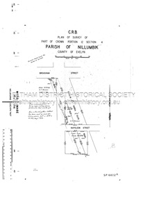
Document - Survey Plan, Country Roads Board, SP 6802, Eltham-Yarra Glen Road; Brougham St to Dalton St, 1958
... E. M. Graham...L.C. Skipper...L.M. Jarrold...Main Road...Napoleon Street...Survey Plan...Neil Webster...E. M. Graham L.C. Skipper L.M. Jarrold Main Road Napoleon Street Survey Plan Neil Webster Collection Franco and Co A3 print, 3 pages and electronic PDF file SP 6802, Eltham-Yarra Glen Road; Brougham St to Dalton St Document Survey Plan Country Roads Board ...1958 C.R.B. Plan of Survey of Part of Crown Portion 12 Section 4 Parish of Nillumbik, County of Evelyn Eltham-Yarra Glen Road, Shire of Eltham Shows Surveyor field notes, property ownership and building type and construction.1958, eltham-yarra glen road, a.f. munday, bible street, brougham steet, country roads board, dalton street, eltham, j.p. & e.a. sanders, j.w. & e. m. graham, l.c. skipper, l.m. jarrold, main road, napoleon street, survey plan, neil webster collection, franco and co -
 Eltham District Historical Society Inc
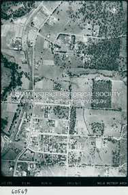
Photograph - Aerial Photograph, Landata, Eltham, Main Road; Henry St to Bellevue Rd, Dec. 1945
... Eltham District Historical Society Inc 728 Main Rd Eltham melbourne Eltham, Main Road; Henry St to Bellevue Rd, and east along Luck St to present day Eltham East School Historic Aerial Imagery Source: Landata.vic.gov.au Aerial Photo Details: Project No :5 Project : MELBOURNE AND METROPOLITAN AREA PROJECT Run : 36 Frame : 60549 Date : 12/1945 Film Type : B/W Camera : EAG4 Flying Height : 10200 Scale : 6000 Film Number : 228 GDA2020 : 37°42'45"S, 145°08'59"E MGA2020 : 336903, 5824465 (55) Melways : 21 K4 (ed. 42) Aerial Photo Arthur Street Bellevue Road Bible Street Diamond Street Dudley Street Elsa Court Eltham Eltham East Primary School Gahan House henry street Livingstone Road Luck Street Main Road Pryor Street Neil Webster Collection A3 photo print and electronic PDF file Eltham, Main Road; Henry St to Bellevue Rd Photograph Aerial Photograph Landata ...Eltham, Main Road; Henry St to Bellevue Rd, and east along Luck St to present day Eltham East School Historic Aerial Imagery Source: Landata.vic.gov.au Aerial Photo Details: Project No :5 Project : MELBOURNE AND METROPOLITAN AREA PROJECT Run : 36 Frame : 60549 Date : 12/1945 Film Type : B/W Camera : EAG4 Flying Height : 10200 Scale : 6000 Film Number : 228 GDA2020 : 37°42'45"S, 145°08'59"E MGA2020 : 336903, 5824465 (55) Melways : 21 K4 (ed. 42)aerial photo, arthur street, bellevue road, bible street, diamond street, dudley street, elsa court, eltham, eltham east primary school, gahan house, henry street, livingstone road, luck street, main road, pryor street, neil webster collection -
 Eltham District Historical Society Inc
Photograph - Aerial Photograph, Landata, Eltham, Luck St; Bible St to Beard St, Dec. 1945
... Eltham District Historical Society Inc 728 Main Rd Eltham melbourne Centred on present day Eltham East Primary School, east of Main Rd along Luck St to Beard St Historic Aerial Imagery Source: Landata.vic.gov.au Aerial Photo Details: Project No :5 Project : MELBOURNE AND METROPOLITAN AREA PROJECT Run : 36 Frame : 60548 Date : 12/1945 Film Type : B/W Camera : EAG4 Flying Height : 10200 Scale : 6000 Film Number : 195 GDA2020 : 37°42'46"S, 145°09'18"E MGA2020 : 337371, 5824456 (55) Melways : 22 A4 (ed. 42) Aerial Photo Eltham Arthur Street Beard Street Bible Street Eltham East Primary School frank street henry street Luck Street Stanley Avenue Wycliffe Crescent Neil Webster Collection A3 photo print and electronic PDF file Eltham, Luck St; Bible St to Beard St Photograph Aerial Photograph Landata ...Centred on present day Eltham East Primary School, east of Main Rd along Luck St to Beard St Historic Aerial Imagery Source: Landata.vic.gov.au Aerial Photo Details: Project No :5 Project : MELBOURNE AND METROPOLITAN AREA PROJECT Run : 36 Frame : 60548 Date : 12/1945 Film Type : B/W Camera : EAG4 Flying Height : 10200 Scale : 6000 Film Number : 195 GDA2020 : 37°42'46"S, 145°09'18"E MGA2020 : 337371, 5824456 (55) Melways : 22 A4 (ed. 42)aerial photo, eltham, arthur street, beard street, bible street, eltham east primary school, frank street, henry street, luck street, stanley avenue, wycliffe crescent, neil webster collection -
 Eltham District Historical Society Inc
Photograph - Aerial Photograph, Landata, Eltham, Main Rd; Railway Rd to Zig Zag Rd, Dec. 1945
... Eltham District Historical Society Inc 728 Main Rd Eltham melbourne Centred on present day Edendale Farm from Glen Park rd to Zig Zag Rd Historic Aerial Imagery Source: Landata.vic.gov.au Aerial Photo Details: Project No :5 Project : MELBOURNE AND METROPOLITAN AREA PROJECT Run : 37 Frame : 60549 Date : 12/1945 Film Type : B/W Camera : EAG4 Flying Height : 10200 Scale : 6000 Film Number : 196 GDA2020 : 37°42'12"S, 145°09'09"E MGA2020 : 337141, 5825486 (55) Melways : 21 K2 (ed. 42) Aerial Photo Eltham Edendale Farm eltham - yarra glen road Eltham-Hurstbridge Railway line Gastons Homestead Gastons Road Glen Park Road Main Road Park Road railway road Wattletree Road Zig Zag Road Neil Webster Collection A3 photo print and electronic PDF file Eltham, Main Rd; Railway Rd to Zig Zag Rd Photograph Aerial Photograph Landata ...Centred on present day Edendale Farm from Glen Park rd to Zig Zag Rd Historic Aerial Imagery Source: Landata.vic.gov.au Aerial Photo Details: Project No :5 Project : MELBOURNE AND METROPOLITAN AREA PROJECT Run : 37 Frame : 60549 Date : 12/1945 Film Type : B/W Camera : EAG4 Flying Height : 10200 Scale : 6000 Film Number : 196 GDA2020 : 37°42'12"S, 145°09'09"E MGA2020 : 337141, 5825486 (55) Melways : 21 K2 (ed. 42)aerial photo, eltham, edendale farm, eltham - yarra glen road, eltham-hurstbridge railway line, gastons homestead, gastons road, glen park road, main road, park road, railway road, wattletree road, zig zag road, neil webster collection -
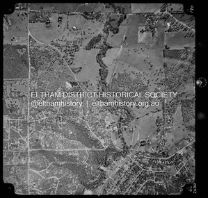
 Eltham District Historical Society Inc
Photograph - Aerial Photograph, Landata, Eltham, Main Road; Mt Pleasant Rd to Railway Rd, Dec. 1945
... Historic Aerial Imagery Source: Landata.vic.gov.au Aerial Photo Details: Project No :65 Project : MELBOURNE AND METROPOLITAN PROJECT NO. 2 Run : 8 Frame : 70 Date : 01/1951 Film Type : B/W Camera : EAG9 Flying Height : 12200 Scale : 12000 Film Number : 1419 GDA2020 : 37°43'06"S, 145°08'45"E MGA2020 : 336589, 5823811 (55) Melways : 21 J6 (ed. 42) Aerial Photo Eltham Main Road Henry Street Arthur Street Bolton Street Eltham-Yarra Glen Road Neil Webster Collection 1951-01 Dave Lyon House Ernie Andrew house Karingal Road Melway 21J6 Mount Pleasant Road railway road A3 photo print and electronic PDF file Eltham, Main Road; Mt Pleasant Rd to Railway Rd Photograph Aerial Photograph Landata ...Centred on Main Rd and Henry St, Eltham bounded by Railway Road to north, Mount Pleasant Road at Main Road to south, top of the hill in Arthur Street to east and Karingal Drive at Sherbourne Road to west. Historic Aerial Imagery Source: Landata.vic.gov.au Aerial Photo Details: Project No :65 Project : MELBOURNE AND METROPOLITAN PROJECT NO. 2 Run : 8 Frame : 70 Date : 01/1951 Film Type : B/W Camera : EAG9 Flying Height : 12200 Scale : 12000 Film Number : 1419 GDA2020 : 37°43'06"S, 145°08'45"E MGA2020 : 336589, 5823811 (55) Melways : 21 J6 (ed. 42)aerial photo, eltham, main road, henry street, arthur street, bolton street, eltham-yarra glen road, neil webster collection, 1951-01, dave lyon house, ernie andrew house, karingal road, melway 21j6, mount pleasant road, railway road -
 Eltham District Historical Society Inc
Photograph - Aerial Photograph, Landata, Eltham and Lower Plenty, Nov. 1931
... Eltham District Historical Society Inc 728 Main Rd Eltham melbourne Centred over present-day Rosehill Road and View Road, Lower Plenty Historic Aerial Imagery Source: Landata.vic.gov.au Aerial Photo Details: Project No :1931 Project : MALDON PRISON Run : 19 Frame : 3129 Date : 11/1931 Film Type : B/W Camera : F8 Flying Height : 11000 Scale : 18860 Film Number : 60 GDA2020 : 37°44'16"S, 145°07'40"E MGA2020 : 335039, 5821622 (55) Melways : 21 E11 (ed. 42) Aerial Photo Eltham Lower Plenty Neil Webster Collection Rosehill Road View Road Digital tif and electronic PDF file Eltham and Lower Plenty Photograph Aerial Photograph Landata ...Centred over present-day Rosehill Road and View Road, Lower Plenty Historic Aerial Imagery Source: Landata.vic.gov.au Aerial Photo Details: Project No :1931 Project : MALDON PRISON Run : 19 Frame : 3129 Date : 11/1931 Film Type : B/W Camera : F8 Flying Height : 11000 Scale : 18860 Film Number : 60 GDA2020 : 37°44'16"S, 145°07'40"E MGA2020 : 335039, 5821622 (55) Melways : 21 E11 (ed. 42)aerial photo, eltham, lower plenty, neil webster collection, rosehill road, view road -
 Eltham District Historical Society Inc
Photograph - Aerial Photograph, Landata, Eltham and Montmorency, Nov. 1931
... Eltham District Historical Society Inc 728 Main Rd Eltham melbourne Centred over present-day Belmont Reserve, Montmorency Historic Aerial Imagery Source: Landata.vic.gov.au Aerial Photo Details: Project No :1931 Project : MALDON PRISON Run : 19 Frame : 3130 Date : 11/1931 Film Type : B/W Camera : F8 Flying Height : 11000 Scale : 18860 Film Number : 60 GDA2020 : 37°43'13"S, 145°07'54"E MGA2020 : 335330, 5823576 (55) Melways : 21 F6 (ed. 42) Aerial Photo Eltham Neil Webster Collection Belmont Reserve Montmorency Rattray Road Digital tif and electronic PDF file Eltham and Montmorency Photograph Aerial Photograph Landata ...Centred over present-day Belmont Reserve, Montmorency Historic Aerial Imagery Source: Landata.vic.gov.au Aerial Photo Details: Project No :1931 Project : MALDON PRISON Run : 19 Frame : 3130 Date : 11/1931 Film Type : B/W Camera : F8 Flying Height : 11000 Scale : 18860 Film Number : 60 GDA2020 : 37°43'13"S, 145°07'54"E MGA2020 : 335330, 5823576 (55) Melways : 21 F6 (ed. 42)aerial photo, eltham, neil webster collection, belmont reserve, montmorency, rattray road -
 Eltham District Historical Society Inc
Photograph - Aerial Photograph, Landata, Eltham and Eltham North, Nov. 1931
... Eltham District Historical Society Inc 728 Main Rd Eltham melbourne Centred over present-day Opal Court and Manning Road, Eltham North Historic Aerial Imagery Source: Landata.vic.gov.au Aerial Photo Details: Project No :1931 Project : MALDON PRISON Run : 19 Frame : 3131 Date : 11/1931 Film Type : B/W Camera : F8 Flying Height : 11000 Scale : 18860 Film Number : 60 GDA2020 : 37°42'10"S, 145°08'07"E MGA2020 : 335621, 5825531 (55) Melways : 21 G2 (ed. 42) Aerial Photo Eltham Neil Webster Collection Eltham North Manning Road Opal Court Digital tif and electronic PDF file Eltham and Eltham North Photograph Aerial Photograph Landata ...Centred over present-day Opal Court and Manning Road, Eltham North Historic Aerial Imagery Source: Landata.vic.gov.au Aerial Photo Details: Project No :1931 Project : MALDON PRISON Run : 19 Frame : 3131 Date : 11/1931 Film Type : B/W Camera : F8 Flying Height : 11000 Scale : 18860 Film Number : 60 GDA2020 : 37°42'10"S, 145°08'07"E MGA2020 : 335621, 5825531 (55) Melways : 21 G2 (ed. 42)aerial photo, eltham, neil webster collection, eltham north, manning road, opal court -
 Eltham District Historical Society Inc
Photograph - Aerial Photograph, Landata, Eltham and Eltham East, Nov. 1931
... Eltham District Historical Society Inc 728 Main Rd Eltham melbourne Centred over present-day Beard Street bewteen Park Road and Main Road, Eltham East Historic Aerial Imagery Source: Landata.vic.gov.au Aerial Photo Details: Project No :1931 Project : MALDON PRISON Run : 20 Frame : 3135 Date : 11/1931 Film Type : B/W Camera : F8 Flying Height : 11000 Scale : 18860 Film Number : 60 GDA2020 : 37°42'16"S, 145°09'41"E MGA2020 : 337912, 5825386 (55) Melways : 22 B2 (ed. 42) Aerial Photo Eltham Neil Webster Collection Beard Street Eltham East Main Road Park Road Digital tif and electronic PDF file Eltham and Eltham East Photograph Aerial Photograph Landata ...Centred over present-day Beard Street bewteen Park Road and Main Road, Eltham East Historic Aerial Imagery Source: Landata.vic.gov.au Aerial Photo Details: Project No :1931 Project : MALDON PRISON Run : 20 Frame : 3135 Date : 11/1931 Film Type : B/W Camera : F8 Flying Height : 11000 Scale : 18860 Film Number : 60 GDA2020 : 37°42'16"S, 145°09'41"E MGA2020 : 337912, 5825386 (55) Melways : 22 B2 (ed. 42)aerial photo, eltham, neil webster collection, beard street, eltham east, main road, park road -
 Eltham District Historical Society Inc
Photograph - Aerial Photograph, Landata, Eltham, Nov. 1931
... Eltham District Historical Society Inc 728 Main Rd Eltham melbourne Centred over present-day Laleham Court between Arthur Street and Hartland Way, Eltham Historic Aerial Imagery Source: Landata.vic.gov.au Aerial Photo Details: Project No :1931 Project : MALDON PRISON Run : 20 Frame : 3136 Date : 11/1931 Film Type : B/W Camera : F8 Flying Height : 11000 Scale : 18860 Film Number : 60 GDA2020 : 37°42'56"S, 145°09'33"E MGA2020 : 337759, 5824139 (55) Melways : 22 B5 (ed. 42) Aerial Photo Eltham Neil Webster Collection Arthur Street Hartland Way Laleham Court Digital tif and electronic PDF file Eltham Photograph Aerial Photograph Landata ...Centred over present-day Laleham Court between Arthur Street and Hartland Way, Eltham Historic Aerial Imagery Source: Landata.vic.gov.au Aerial Photo Details: Project No :1931 Project : MALDON PRISON Run : 20 Frame : 3136 Date : 11/1931 Film Type : B/W Camera : F8 Flying Height : 11000 Scale : 18860 Film Number : 60 GDA2020 : 37°42'56"S, 145°09'33"E MGA2020 : 337759, 5824139 (55) Melways : 22 B5 (ed. 42) aerial photo, eltham, neil webster collection, arthur street, hartland way, laleham court -
 Eltham District Historical Society Inc
Photograph - Aerial Photograph, Landata, Eltham, Nov. 1931
... Eltham District Historical Society Inc 728 Main Rd Eltham melbourne Centred over Mount Pleasant Road and Kent Hughes Road, Eltham Historic Aerial Imagery Source: Landata.vic.gov.au Aerial Photo Details: Project No :1931 Project : MALDON PRISON Run : 20 Frame : 3137 Date : 11/1931 Film Type : B/W Camera : F8 Flying Height : 11000 Scale : 18860 Film Number : 60 GDA2020 : 37°43'37"S, 145°09'26"E MGA2020 : 337606, 5822892 (55) Melways : 22 A8 (ed. 42) Aerial Photo Eltham Neil Webster Collection Kent Hughes Road Mount Pleasant Road Digital tif and electronic PDF file Eltham Photograph Aerial Photograph Landata ...Centred over Mount Pleasant Road and Kent Hughes Road, Eltham Historic Aerial Imagery Source: Landata.vic.gov.au Aerial Photo Details: Project No :1931 Project : MALDON PRISON Run : 20 Frame : 3137 Date : 11/1931 Film Type : B/W Camera : F8 Flying Height : 11000 Scale : 18860 Film Number : 60 GDA2020 : 37°43'37"S, 145°09'26"E MGA2020 : 337606, 5822892 (55) Melways : 22 A8 (ed. 42) aerial photo, eltham, neil webster collection, kent hughes road, mount pleasant road -
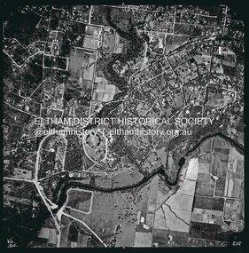 Eltham District Historical Society Inc
Photograph - Aerial Photograph, Landata, Eltham, Vic, Apr. 1963
... Historic Aerial Imagery Source: Landata.vic.gov.au Aerial Photo Details: Project No :486 Project : MELBOURNE (1963) PROJECT Run : 7 Frame : 232 Date : 04/1963 Film Type : B/W Camera : RC8 Flying Height : 5100 Scale : 9600 Film Number : 1805 GDA2020 : 37°44'03"S, 145°08'33"E MGA2020 : 336329, 5822040 (55) Melways : 21 H10 (ed. 42) Aerial Photo Neil Webster Collection 1963-04 Bolton Steet Brougham Steet Eltham Eltham Lower Park Fitzsimons Lane Bridge Kent Hughes Road Melway 21H10 Yarra River Digital jpg and electronic PDF file Eltham, Vic. ...Centred on present day Eltham Lower Park bounded by Brougham Street to north, Yarra River and Fitzsimons Lane Bridge to south, Main Road at Kent Hughes Road to east and Bolton Street to west. Historic Aerial Imagery Source: Landata.vic.gov.au Aerial Photo Details: Project No :486 Project : MELBOURNE (1963) PROJECT Run : 7 Frame : 232 Date : 04/1963 Film Type : B/W Camera : RC8 Flying Height : 5100 Scale : 9600 Film Number : 1805 GDA2020 : 37°44'03"S, 145°08'33"E MGA2020 : 336329, 5822040 (55) Melways : 21 H10 (ed. 42)aerial photo, neil webster collection, 1963-04, bolton steet, brougham steet, eltham, eltham lower park, fitzsimons lane bridge, kent hughes road, melway 21h10, yarra river -
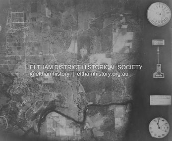
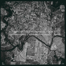 Eltham District Historical Society Inc
Photograph - Aerial Photograph, Landata, Eltham, Vic, Apr. 1963
... Historic Aerial Imagery Source: Landata.vic.gov.au Aerial Photo Details: Project No :486 Project : MELBOURNE (1963) PROJECT Run : 7 Frame : 233 Date : 04/1963 Film Type : B/W Camera : RC8 Flying Height : 5100 Scale : 9600 Film Number : 1805 GDA2020 : 37°44'04"S, 145°09'10"E MGA2020 : 337237, 5822053 (55) Melways : 22 A10 (ed. 42) Aerial Photo Neil Webster Collection 1963-04 Eltham Falkiner Street Griffith Park Road Melway 22A10 Mount Pleasant Road Reynolds Road Templestowe Yarra River Digital jpg and electronic PDF file Eltham, Vic. ...Centred on present day Griffith Park Road, Eltham bounded by Mount Pleasant Road to north, Yarra River and Templestowe to south, Main Road at Reynolds Road to east and Falkiner Street to west. Historic Aerial Imagery Source: Landata.vic.gov.au Aerial Photo Details: Project No :486 Project : MELBOURNE (1963) PROJECT Run : 7 Frame : 233 Date : 04/1963 Film Type : B/W Camera : RC8 Flying Height : 5100 Scale : 9600 Film Number : 1805 GDA2020 : 37°44'04"S, 145°09'10"E MGA2020 : 337237, 5822053 (55) Melways : 22 A10 (ed. 42)aerial photo, neil webster collection, 1963-04, eltham, falkiner street, griffith park road, melway 22a10, mount pleasant road, reynolds road, templestowe, yarra river -
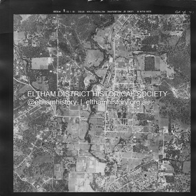
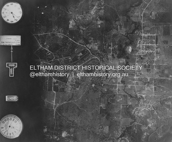
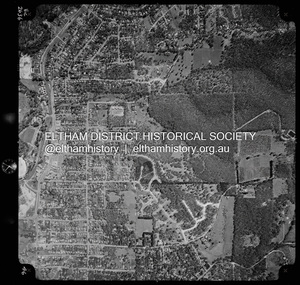
 Eltham District Historical Society Inc
Photograph - Aerial Photograph, Landata, Eltham North, Vic, Apr. 1972
... Historic Aerial Imagery Source: Landata.vic.gov.au Aerial Photo Details: Project No :985 Project : MELBOURNE 1972 Run : 26 Frame : 190 Date : 04/1972 Film Type : B/W Camera : RC10 Flying Height : 5700 Scale : 9600 Film Number : 2636 GDA2020 : 37°41'52"S, 145°08'52"E MGA2020 : 336705, 5826102 (55) Melways : 11 J12 (ed. 42) Aerial Photo Neil Webster Collection 1972-04 Allendale Road Beard Street Bellevue Road Eltham Eltham North Eltham North reserve Melway 11J12 Ryans Road Zig Zag Road Eltham North Primary School Digital jpg and electronic PDF file Eltham North, Vic. ...Centred on present day Eltham North reserve near Eltham North Primary School, Eltham North bounded by Allendale Road to north, Bellevue Road to south, Zig Zag Road and Beard Street to east and Ryans Road to west. Historic Aerial Imagery Source: Landata.vic.gov.au Aerial Photo Details: Project No :985 Project : MELBOURNE 1972 Run : 26 Frame : 190 Date : 04/1972 Film Type : B/W Camera : RC10 Flying Height : 5700 Scale : 9600 Film Number : 2636 GDA2020 : 37°41'52"S, 145°08'52"E MGA2020 : 336705, 5826102 (55) Melways : 11 J12 (ed. 42)aerial photo, neil webster collection, 1972-04, allendale road, beard street, bellevue road, eltham, eltham north, eltham north reserve, melway 11j12, ryans road, zig zag road, eltham north primary school -
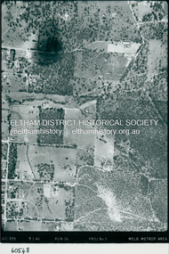
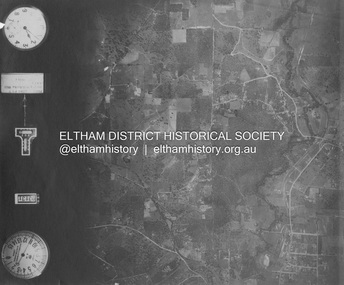
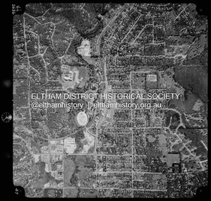
 Eltham District Historical Society Inc
Photograph - Aerial Photograph, Landata, Eltham, Vic, Apr. 1972
... Historic Aerial Imagery Source: Landata.vic.gov.au Aerial Photo Details: Project No :985 Project : MELBOURNE 1972 Run : 26 Frame : 191 Date : 04/1972 Film Type : B/W Camera : RC10 Flying Height : 5700 Scale : 9600 Film Number : 2636 GDA2020 : 37°41'56"S, 145°09'26"E MGA2020 : 337533, 5826000 (55) Melways : 22 A1 (ed. 42) Aerial Photo Neil Webster Collection 1972-04 Allendale Road Eltham Eltham North Zig Zag Road Banks Road Coolabah Drive Melway 22A1 Park West Road Parsons Road Digital jpg and electronic PDF file Eltham, Vic. ...Centred on present day Zig Zag Road near Coolabah Drive, Eltham bounded by Allendale Road to north, Park West Road to south, Parsons Road to east and Banks Road to west. Historic Aerial Imagery Source: Landata.vic.gov.au Aerial Photo Details: Project No :985 Project : MELBOURNE 1972 Run : 26 Frame : 191 Date : 04/1972 Film Type : B/W Camera : RC10 Flying Height : 5700 Scale : 9600 Film Number : 2636 GDA2020 : 37°41'56"S, 145°09'26"E MGA2020 : 337533, 5826000 (55) Melways : 22 A1 (ed. 42)aerial photo, neil webster collection, 1972-04, allendale road, eltham, eltham north, zig zag road, banks road, coolabah drive, melway 22a1, park west road, parsons road -
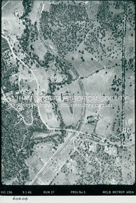
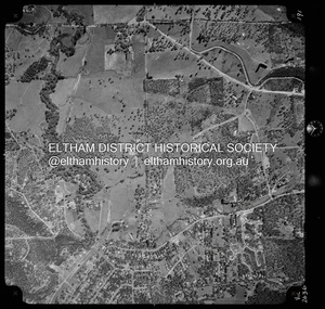
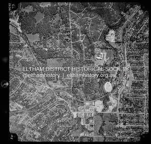
 Eltham District Historical Society Inc
Photograph - Aerial Photograph, Landata, Eltham, Vic, Apr. 1972
... Historic Aerial Imagery Source: Landata.vic.gov.au Aerial Photo Details: Project No :985 Project : MELBOURNE 1972 Run : 26 Frame : 192 Date : 04/1972 Film Type : B/W Camera : RC10 Flying Height : 5700 Scale : 9600 Film Number : 2636 GDA2020 : 37°42'00"S, 145°09'59"E MGA2020 : 338360, 5825897 (55) Melways : 22 D1 (ed. 42) Aerial Photo Neil Webster Collection 1972-04 Allendale Road Eltham Zig Zag Road frank street Melway 22D1 Parsons Road Raglan Road Research (Vic.) ...Centred on present day Parsons Road, Eltham bounded by Allendale Road to north, Frank Street to south, Research Shops and Raglan Road to east and Zig Zag Road to west. Historic Aerial Imagery Source: Landata.vic.gov.au Aerial Photo Details: Project No :985 Project : MELBOURNE 1972 Run : 26 Frame : 192 Date : 04/1972 Film Type : B/W Camera : RC10 Flying Height : 5700 Scale : 9600 Film Number : 2636 GDA2020 : 37°42'00"S, 145°09'59"E MGA2020 : 338360, 5825897 (55) Melways : 22 D1 (ed. 42)aerial photo, neil webster collection, 1972-04, allendale road, eltham, zig zag road, frank street, melway 22d1, parsons road, raglan road, research (vic.), research shops, eltham barrel -
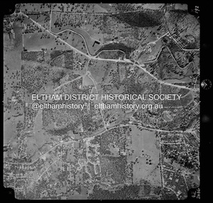
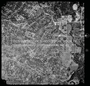
 Eltham District Historical Society Inc
Photograph - Aerial Photograph, Landata, Research, Vic, Apr. 1972
... Historic Aerial Imagery Source: Landata.vic.gov.au Aerial Photo Details: Project No :985 Project : MELBOURNE 1972 Run : 26 Frame : 193 Date : 04/1972 Film Type : B/W Camera : RC10 Flying Height : 5700 Scale : 9600 Film Number : 2636 GDA2020 : 37°42'04"S, 145°10'33"E MGA2020 : 339187, 5825794 (55) Melways : 22 F1 (ed. 42) Aerial Photo Neil Webster Collection 1972-04 Allendale Road Eltham Eltham Barrel Eltham College Maroong Drive Melway 22F1 Parsons Road Research (Vic.) ...Centred on present day Maroong Drive, Research bounded by Allendale Road to north, Thompson Crescent to south, Eltham College to east and Parsons Road to west. Historic Aerial Imagery Source: Landata.vic.gov.au Aerial Photo Details: Project No :985 Project : MELBOURNE 1972 Run : 26 Frame : 193 Date : 04/1972 Film Type : B/W Camera : RC10 Flying Height : 5700 Scale : 9600 Film Number : 2636 GDA2020 : 37°42'04"S, 145°10'33"E MGA2020 : 339187, 5825794 (55) Melways : 22 F1 (ed. 42)aerial photo, neil webster collection, 1972-04, allendale road, eltham, eltham barrel, eltham college, maroong drive, melway 22f1, parsons road, research (vic.), thompson crescent -
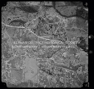
 Eltham District Historical Society Inc
Photograph - Aerial Photograph, Landata, Research, Vic, Apr. 1972
... Historic Aerial Imagery Source: Landata.vic.gov.au Aerial Photo Details: Project No :985 Project : MELBOURNE 1972 Run : 26 Frame : 194 Date : 04/1972 Film Type : B/W Camera : RC10 Flying Height : 5700 Scale : 9600 Film Number : 2636 GDA2020 : 37°42'07"S, 145°11'07"E MGA2020 : 340015, 5825692 (55) Melways : 22 H1 (ed. 42) Aerial Photo Neil Webster Collection 1972-04 Allendale Road Eltham College Main Road Maroondah Aqueduct Melway 22H1 Research (Vic.) ...Centred on present day Main Road, Research near Maroondah Aqueduct and Eltham College bounded by Allendale Road to north, Research-Warrandyte Road to south, Swipers Gully Training Restaurant to east and Reynolds Road to west. Historic Aerial Imagery Source: Landata.vic.gov.au Aerial Photo Details: Project No :985 Project : MELBOURNE 1972 Run : 26 Frame : 194 Date : 04/1972 Film Type : B/W Camera : RC10 Flying Height : 5700 Scale : 9600 Film Number : 2636 GDA2020 : 37°42'07"S, 145°11'07"E MGA2020 : 340015, 5825692 (55) Melways : 22 H1 (ed. 42)aerial photo, neil webster collection, 1972-04, allendale road, eltham college, main road, maroondah aqueduct, melway 22h1, research (vic.), research-warrandyte road, reynolds road, swiper's gully -
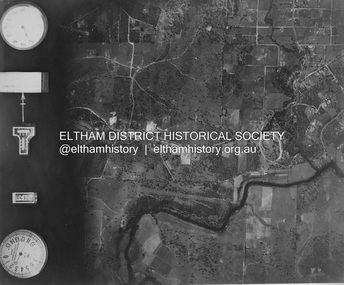
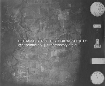
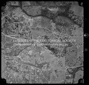
 Eltham District Historical Society Inc
Photograph - Aerial Photograph, Landata, Eltham, Vic, Apr. 1972
... Historic Aerial Imagery Source: Landata.vic.gov.au Aerial Photo Details: Project No :985 Project : MELBOURNE 1972 Run : 27 Frame : 46 Date : 04/1972 Film Type : B/W Camera : RC10 Flying Height : 5700 Scale : 9600 Film Number : 2636 GDA2020 : 37°42'49"S, 145°09'46"E MGA2020 : 338053, 5824365 (55) Melways : 22 C5 (ed. 42) Aerial Photo Neil Webster Collection 1972-04 Eltham Eltham Railway Station Melway 22C5 Mount Pleasant Road Park Road Stokes Orchard Estate Woodridge Estate Digital jpg and electronic PDF file Eltham, Vic. ...Centred on present day Woodridge Estate, Eltham bounded by Park Road to north, Mount Pleasant Road to south, Stokes Orchard Estate to east and Eltham Railway Station to west. Historic Aerial Imagery Source: Landata.vic.gov.au Aerial Photo Details: Project No :985 Project : MELBOURNE 1972 Run : 27 Frame : 46 Date : 04/1972 Film Type : B/W Camera : RC10 Flying Height : 5700 Scale : 9600 Film Number : 2636 GDA2020 : 37°42'49"S, 145°09'46"E MGA2020 : 338053, 5824365 (55) Melways : 22 C5 (ed. 42)aerial photo, neil webster collection, 1972-04, eltham, eltham railway station, melway 22c5, mount pleasant road, park road, stokes orchard estate, woodridge estate -
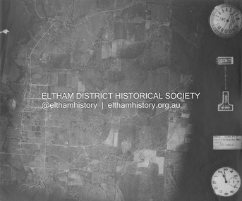
 Eltham District Historical Society Inc
Photograph - Aerial Photograph, Landata, Eltham, Vic, Apr. 1972
... Historic Aerial Imagery Source: Landata.vic.gov.au Aerial Photo Details: Project No :985 Project : MELBOURNE 1972 Run : 27 Frame : 47 Date : 04/1972 Film Type : B/W Camera : RC10 Flying Height : 5700 Scale : 9600 Film Number : 2636 GDA2020 : 37°42'45"S, 145°09'12"E MGA2020 : 337223, 5824470 (55) Melways : 22 A4 (ed. 42) Aerial Photo Neil Webster Collection 1972-04 Eltham Eltham Railway Station Woodridge Estate Eltham Shops Main Road Melway 22A4 Napoleon Street Park West Road Pryor Street Ryans Road Digital jpg and electronic PDF file Eltham, Vic. ...Centred on present day Main Road at Pryor Street, Eltham bounded by Park West Road to north, Napoleon Street to south, Woodridge Estate to east and Ryans Road to west. Historic Aerial Imagery Source: Landata.vic.gov.au Aerial Photo Details: Project No :985 Project : MELBOURNE 1972 Run : 27 Frame : 47 Date : 04/1972 Film Type : B/W Camera : RC10 Flying Height : 5700 Scale : 9600 Film Number : 2636 GDA2020 : 37°42'45"S, 145°09'12"E MGA2020 : 337223, 5824470 (55) Melways : 22 A4 (ed. 42)aerial photo, neil webster collection, 1972-04, eltham, eltham railway station, woodridge estate, eltham shops, main road, melway 22a4, napoleon street, park west road, pryor street, ryans road -
 Eltham District Historical Society Inc
Photograph - Aerial Photograph, Landata, Eltham, Vic, Apr. 1972
... Historic Aerial Imagery Source: Landata.vic.gov.au Aerial Photo Details: Project No :985 Project : MELBOURNE 1972 Run : 27 Frame : 48 Date : 04/1972 Film Type : B/W Camera : RC10 Flying Height : 5700 Scale : 9600 Film Number : 2636 GDA2020 : 37°42'41"S, 145°08'38"E MGA2020 : 336392, 5824574 (55) Melways : 21 H4 (ed. 42) Aerial Photo Neil Webster Collection 1972-04 Eltham Bible Street Brougham Steet Melway 21H4 outlook crescent Progress Road Ryans Road Sandra Avenue Montmorency Digital jpg and electronic PDF file Eltham, Vic. ...Centred on present day Ryans Road at Sandra Avenue, Eltham bounded by Progress Road to north, Brougham Street to south, Bible Street to east and Outlook Crescent to west. Historic Aerial Imagery Source: Landata.vic.gov.au Aerial Photo Details: Project No :985 Project : MELBOURNE 1972 Run : 27 Frame : 48 Date : 04/1972 Film Type : B/W Camera : RC10 Flying Height : 5700 Scale : 9600 Film Number : 2636 GDA2020 : 37°42'41"S, 145°08'38"E MGA2020 : 336392, 5824574 (55) Melways : 21 H4 (ed. 42)aerial photo, neil webster collection, 1972-04, eltham, bible street, brougham steet, melway 21h4, outlook crescent, progress road, ryans road, sandra avenue, montmorency -
 Eltham District Historical Society Inc
Photograph - Aerial Photograph, Landata, Montmorency, Vic, Apr. 1972
... Historic Aerial Imagery Source: Landata.vic.gov.au Aerial Photo Details: Project No :985 Project : MELBOURNE 1972 Run : 28 Frame : 206 Date : 04/1972 Film Type : B/W Camera : RC10 Flying Height : 5700 Scale : 9600 Film Number : 2635 GDA2020 : 37°43'21"S, 145°07'46"E MGA2020 : 335154, 5823329 (55) Melways : 21 E7 (ed. 42) Aerial Photo Neil Webster Collection 1972-04 Eltham Alban Street Grand Boulevard Lower Plenty Main Road Melway 21E7 Meruka Drive Montmorency Olympic Avenue Digital jpg and electronic PDF file Montmorency, Vic. ...Centred on present day Olympic Avenue at Grand Boulevard, Montmorency bounded by Meruka Drive to north, Main Road to south, Main Road to east and Alban Street to west. Historic Aerial Imagery Source: Landata.vic.gov.au Aerial Photo Details: Project No :985 Project : MELBOURNE 1972 Run : 28 Frame : 206 Date : 04/1972 Film Type : B/W Camera : RC10 Flying Height : 5700 Scale : 9600 Film Number : 2635 GDA2020 : 37°43'21"S, 145°07'46"E MGA2020 : 335154, 5823329 (55) Melways : 21 E7 (ed. 42)aerial photo, neil webster collection, 1972-04, eltham, alban street, grand boulevard, lower plenty, main road, melway 21e7, meruka drive, montmorency, olympic avenue