Showing 12 items matching " gold fields police"
-
 Bendigo Historical Society Inc.
Document - HERITAGE REPORT: FORMER POLICE STATION AND QUARTERS: CALIFORNIA GULLY
... ... Gold Fields Police...History House 11 Mackenzie Street Bendigo goldfields HERITAGE Heritage Report - Former Police Station and Quarters - California Gully City of Greater Bendigo Wilson & Ass Butler Amanda Jean Johnson Reef Shafts No 1 & 2 Rose of Denmark Princess Dagmar Bendigo Amalgamated Goldfields Company Captain Frederick Standish Royal Irish Constabulary E Thorpe Campbell Taylor Watson Brown Hosken McKowne McQualter Parker Hicks Eaglehawk Municipal Council Victorian Police Force D Bannear Historic Mining sites in the Sandhurst Eaglehawk and Raywood Mining Divisions Department of Conservation and Natural Resources Joshua Thorpe Thorpe & Co Johnson & Co William Thorn Michael Thomas James Murdock Edward C Brown Francis Youlden Gold Escort Water Police Mounted Police City Police (Melbourne) Geelong Police Gold Fields Police Rural Bench Constabulary The People's Force Robert Haldane N Wild Streets of the Borough of Eaglehawk Police Registration Act William Henry Mitchell Camp Hotel J O C Nieman J M Catarach G W Hosken Margaret Hosken nee McKown Majorie Alice McQualter Kellie Anne McQualter Adam Joseph Doolan Mr Hicks Sands & McDougall Hill George Meeking Howard McEwan Frank A Jinks Stanley McCaig Mrs Eleanor Gordon John L McQualter Mrs Adeline Maher William L Raynor Robert Flack John P Whitehead Miss A Sang George T Linddsay John P Dyer Henry Jackman George A Tibbetts Mrs S A Hosken Mrs Margaret Winifred nee McKowne Chaplin Frank W Wilson C E Wright George Miller G A Sheyhill Basil Hugh Marshall R Miles J H Parker W B Barkla W G Nicholls Les Cartledge Clifford William Cole Charles Basil Farmers Citizens Trustees Co Bev Hanson Seventeen page Heritage Place Report on the Former California Gully Police Station at 15 Thorpe Street, California Gully. ...Seventeen page Heritage Place Report on the Former California Gully Police Station at 15 Thorpe Street, California Gully. It is the former police station and quarters, former timber stables and timber cottage residence demolished and horse paddock on separate title. Report includes a Statement of Significance, Place History (History of the Area), Policing California Gully Goldfields, History of the Buildings, Chronology of Ownership, Rate Books 1858, - 1867 - 1868, 1895 Borough of Eaglehawk Rates, 1922 Voters Roll, 1952 & 1962 Sands & McDougall Directory Thorpe St California Gully, Comparable Examples, Secondary Sources, Description Conservation Policy Guidelines (Specific), Physical Conditions, Physical Description 1, Map of Early Photo Location, Bendigo Parish Plan circa 1870, Certificate of Title 1950 & 1960. Pge 14 has plans, maps and an aerial photo of 15 Thorpe Street. Page 15 has an aerial photo of 15 Thorpe Street, California Gully with Allotment Size. Page 16 & 17 has photos.heritage, heritage report - former police station and quarters - california gully, city of greater bendigo, wilson & ass, butler, amanda jean, johnson reef shafts no 1 & 2, rose of denmark, princess dagmar, bendigo amalgamated goldfields company, captain frederick standish, royal irish constabulary, e thorpe, campbell, taylor, watson, brown, hosken, mckowne, mcqualter, parker, hicks, eaglehawk municipal council, victorian police force, d bannear, historic mining sites in the sandhurst eaglehawk and raywood mining divisions, department of conservation and natural resources, joshua thorpe, thorpe & co, johnson & co, william thorn, michael thomas, james murdock, edward c brown, francis youlden, gold escort, water police, mounted police, city police (melbourne), geelong police, gold fields police, rural bench constabulary, the people's force, robert haldane, n wild, streets of the borough of eaglehawk, police registration act, william henry mitchell, camp hotel, j o c nieman, j m catarach, g w hosken, margaret hosken nee mckown, majorie alice mcqualter, kellie anne mcqualter, adam joseph doolan, mr hicks, sands & mcdougall, hill george, meeking howard, mcewan frank a, jinks stanley, mccaig mrs eleanor, gordon john l, mcqualter mrs adeline, maher william l, raynor robert, flack john p, whitehead miss a, sang george t, linddsay john p, dyer henry, jackman george a, tibbetts mrs s a, hosken mrs margaret winifred nee mckowne, chaplin frank w, wilson c e, wright george, miller g a, sheyhill basil hugh, marshall r, miles j h, parker w b, barkla w g, nicholls les, cartledge clifford william, cole charles basil, farmers citizens trustees co, bev hanson -
 Federation University Historical Collection
Document, Zelda Martin, Central Victorian Goldmining towns - Boom Towns or Ghost Towns?, c1996
... Gold Fields Act. In accordance with the Act the gold fields are divided into six districts - Ballaarat, Castlemaine , Sandhurst, Avoca, Ararat, and Beechworth.. Official staff in each gold district consists of a Resident Warden, Wardens, Wardens' Clerks, Bailiffs, Chinese Protectors, Chinese Interpreters, and Mining Surveyors. *Gold Receiver *Gaols *Police...Gold Fields Act. In accordance with the Act the gold fields are divided into six districts - Ballaarat, Castlemaine , Sandhurst, Avoca, Ararat, and Beechworth.. Official staff in each gold district consists of a Resident Warden, Wardens, Wardens' Clerks, Bailiffs, Chinese Protectors, Chinese Interpreters, and Mining Surveyors. *Gold Receiver *Gaols *Police ...Zelda Martin was a PhD candidate at the University of Melbourne.[.1] 4th item in light blue display book titled Research Approach/Overview of Chapters/Confirmation of Canditure/Chapters1,2,3&4 of proposed thesis. *Twenty-seven page article on Victorian goldfields towns titled: Central Victorian Goldmining Towns - Boom Towns or Ghost Towns. The article was written during the author's PhD study. It outlines the context methodology, and resources and the chapters of the proposed thesis: (1) Central Victorian Goldmining Towns - The Context (2) Contemporary Views of the Factors Necessary for Town Growth (3) Outward Manifestations of Town Growth (4) The Trappings of Government (5-9) The Main Towns and Their Hinterland. [.2] 5th item in Light Blue display book as above item. *Chapter 1 of proposed thesis titled 'Pick, Shovel and Tin Dish Mining.' Covers in Section A: Central Victoria - Pre 1851: Aborigines in Central Victoria, Squatters, and Government. Section B: The years 1851-1854: The Early Gold Rushes, Government Reaction, Township Surveys, Legislation, Town Development, Local Government and Early Settlement. [.3] 6th item in Light Blue display book as above item. *2A of proposed thesis titled 'Contemporary Views of the Factors Necessary for Town Growth'. Similar information to Chapter 1 plus extra re towns and maps. Sections: Introduction, Context of Place - Geographical Towns Listed, The Context of Time - Pre1851 Aborigines, Governance of Port Phillip, The Squatters, The Villages of Central Victorian Highlands, Conclusion, Condensed Version of Chapter2B. [.4] 7th item in Light Blue display book as above item. *Chapter2B of proposed thesis. Sections: Area of Research, Schools, Banks, Newspapers, Progress Association, Town Development - Sandhurst (Bendigo), Ballarat, Castlemaine,, Maryborough, Ararat and Stawell. [.5] 8th item in Light Blue display book as above item. *Chapter 3 of proposed thesis titled 'Outward Manifestations of Town Growth'. Sections: Introduction, Contemporary Writing, Educationalists, The Bankers, The Townsfolk, Current Theory, General Theories of Urban Development, and Conclusion. [.6] 9th item in Light Blue display book as above item. *Chapter 4 of proposed thesis titled 'Trappings of Government' Sections: Introduction, Early Government Attitudes to Mining and Town Development, Law and Order, Township Surveys, Legislation, Local Government, Transport and Communication, The People and Lobbyists. [.7] 10th item in Light Blue display book as above item. *'The Rise and Fall of Central Victorian Goldmining Towns'. Includes a map showing main Goldfields, a table showing towns and villages at two points in time - 1857 and 1871; a Bibliography of Primary and Secondary Sources. [.8] Resource No1. Black display book titled Local Towns 1 : Alma: *Brief history *Directory *Maps Amphitheatre / Mountain Hut: *Brief History Post Office Directory Ararat: *Brief History *Post Office Directory 1869 - Alphabetical Listing by Occupation *Ararat - Prominent Citizens of 1858 *Langi-Morgala Museum Avoca: *Brief History *Excerpts from 'Avoca The Early Years', Margery and Betty Beavis; pg1 - Beginnings; pg11 - The Midas Touch; pg25 - Local Gold Escorts; pg27 - A Town is Born; pg51- The Administration of Justice; pg53 - The Ways of the Law; pg61 - News of the Day; pg65 - A Time to Play; pg72 - Land Ownership *Post Office Directory (Bailliere's) 1869 *Tourism Map and Information of area *Historic Avoca - A 5.5km Tour *Avoca & the Pyrenees Region - information pamphlet Ballarat: *Early History of Ballarat - Ballarat Historical Society, Publication No.1: origin of the name; Ballaarat - the Beginning; Fabulous Yields from the Ballaarat Goldfield; *Streetscape Lydiard Street. *Hand drawn map showing Leigh River, Old Portland Bay Road, plaque on road to Colac; etc. *Newspaper article re 'The Theatre Royal' ( which stood in the vicinity of the current Owen Williams store) - 'The News'15/04/1998 *Article - 'Ballarat's Mechanics' Institute Lives On' Ballarat Courier, 14/09/1985 *Article - Standing the Test of Time' The News 17/11/1993 re The Mechanics Institute & picture of the Reading Room *'Ballarat a Study of a City, Phyllis Reichl, pub. Nelson, 1968; no.3 place, time and people field studies series *Investigator Vol.33 No.2, 1998 Geelong Historical Society. Article on pg75 describes Ballarat in 1861 *Folded poster - 'Ballarat 100' a history of telegraph communication, pub. Telecom. Beaufort (Fiery Creek): *Brief history *Post Office Directory [.9] Resource No.2 Black Folder Titled Towns cont.No2 Bendigo (Sandhurst): *'Family & Local History at the Bendigo Library - 1851-2001 150 years of gold'. *Bendigo Government Camp in 1853 illustration; key to sketch and names of Government officers stationed there *Excerpts from 'Bendigo and Vicinity' Adolph Haman *The Bendigo Goldfield Registry - pgs 1-7 Introduction *Excerpt: 'Breaking the Grip' *Excerpt: The Most Go-Ahead Place *Excerpts from 'History of Bendigo' - anti license agitation; laying out of town; proposed railway; gold calls and dividends; the Sandhurst Municipality; journalism *Bibliography Blackwood: *Excerpts from 'Aspects of Early Blackwood - The Goldfield, the Landmarks, the Pioneers' Alan J Buckingham and Margaret F Hitchcock, JG Publishing,1980 Buninyong: *A Brief History *Investigator Vol1 No.2 Feb 1966 Geelong Historical Society. Pg3 - Article re gold escort route - Mt Alexander to Adelaide - (see a simple monument on the Western Highway a few miles out of Horsham. Pg 15 - Ballarat Excursion - re the finding of gold. *Three articles published by Buninyong and District Historical Society Inc: (Magpie Exploration; Finding Gold In The Green Hills; Magpie Exploration; Burnt Bridge to Cargarie to Mt Mercer) *Copies of newspaper articles/items *Buninyong Street Directory Carisbrook: *In the Beginning There Was Carisbrook *The History of the Carisbrook Racecourse Carngham / Snake Valley: *Brief History *Directory Castlemaine: *Directory 1865-1866 - Alphabetical and Street *Poster - Castlemaine A Contemporary Guide "The Great Centre" 1866 - A Contemporary Guide to the Fascinating Past *Pamphlet - Castlemaine District Community Hospital *Map - Castlemaine, Maldon & Surrounding Districts *Map and Information - The Dry Diggings Track - a 55kl walk among historic goldfields relics ( Castlemaine Fryerstown Vaughan Mt Franklin Hepburn Daylesford) *Postcard - Former Court House *Directory 1867 - Alphabetical, Trade [.10] Resource No.3 Grey folder Titled Towns 3 Creswick to Maryborough Creswick: *Brief History *Booklet - "Creswick Cemetery Walk" *Booklet - The Buried Rivers of Gold Heritage Trail Creswick *Creswick Historical Museum Information Sheet *Chronological History of Creswick *Alphabetical Directory of the Borough of Creswick *Creswick's Creek Directory 1856 *Historic Creswick Walking Tour *A Brief Account of the Schools of Creswick - Past and Present *100 Years of Railway Travel in Creswick *The Berry Deep Leads *The Spence Home at Jackass Gully in the Creswick State Forest ( William Guthrie Spence - Pioneer) *The New Australian Mine and the 1882 Disaster *Creswick District News, Issue 7, July August 1999 *The Creswick Miners Walk - Information and Map *Maps Chewton: *Brief History *Directory Clunes: *Brief History *Clunes Street Directory Daylesford: *Brief History *Notable Bushfires in Daylesford District Over More Than a Century - "Black Thursday" 1851; 1862; 1899; the Disastrous Hepburn Fire of 1906; 1939; 1944; 1969. *Post Office Directory -Daylesford and Hepburn Dunolly / Inkerman: *Brief History *Directory *Pamphlet - Goldfields Historical Museum *Pamphlet - Historic Dunolly - Victoria's Best Kept Secret *Map of Gold Workings at Dunolly Area - showing where the main gold rushes occurred *Brief History - Inglewood *Directory - Inglewood - Name Occupation, Dwelling Kingower: *Brief History *Directory - Name / Ocupation / Dwelling Linton / Happy Valley / Piggoreet: *Brief History *Directory - Lintons McIvor: *"A History of the Shire and the Township of Heathcote" by J.O. Randell Majorca: *Brief History *Official Post Office Directory 1869 - Name / Occupation/ Address Maldon (Tarrangower): *Brief History Part 1 *Brief History Part 2 *Post Office Directory *List - Alphabetical Order by Names plus Business and Trade (Tarrangower Times Oct/1858) *List - Alphabetical Order by Trade plus Name and Business *Directory - Name / Occupation / Dwelling Maryborough: *Worsley Cottage - built by Arthur Worsley, a contractor in stonework in 1894 [.11] Resource No. 4 Blue Display Book titled Towns 4 Moliagul to Stawell Moliagul: *Brief History *Moligul Legislative Assembly (Voting?) List - Names and Occupations *Moliagul Victorian Post Office Directory 1868 - Name / Ocupation / Address / Comments *"The Welcome Stranger" gold nugget *The Sunday School *The Welcome Stranger Discovery Walk - information and map Moonambel (Mountain Creek) Redbank *Brief History *List of names extracted from advertisments of the Pioneer and Mountain Creek Advertiser 16/02/1861. *Bailliere's Directory 1869 - Alphabetical List of Name / Occupation / Place St Arnaud: *Brief History Sebastapol: *Brief History *Directory 1869 - Alphabetical by Name; plus occupation and address. Browns and Scarsdale: *Brief History *Browns Street Directory - Name and Occupation Smythesdale: *Brief Description *Smythesdale Street Directory -Name and Occupation Stawell (Pleasant Creek) *Brief History *Victorian Official Post Office Directory - Name /Occupation / Dwelling *Chronology - 1841-1920 *Production of gold statistics - 1879 - 1900 *Big Hill *Extracts from "The Golden Years of Stawell". Chapt 1 - Stawell's Coming Out. Capt. 2 - The Gold Rush. Caapt.3 - Cradle of Democracy. Chapt.4 - The Reefs Becomes Stawell. Chapt. 5 - Rushing In. Chapt.6 - The Pioneers. Chapt 7 - The Decade of Optimism. [.12] Resource No. 5: Blue Display Book titled 'Towns Steiglitz to the The Golden Triangle. Steiglitz: Brief History Victorian Post Office Directory 1869 *Map of Steiglitz *List of maps relevant to Steiglitz history *Information 6 tables of data from "Reports of Mining Surveyors Talbot (Back Creek) Brief History Taradale: Post office Directory 1869 - Name/Occupation/Street. Also list in alphabetical order by Occupation Taradale *Chronological Reference to Taradale Mines *Water - The Coliban System of Waterworks *Joseph Brady *The Syphon Tarnagulla (Sandy Creek) *Brief History *Tarnagulla Businessmen Cameos to give depth to advertisments in 'The Tarnagulla Courier' various issues 1864-1871 *Directory - Name/Occupation /Address *List - Name/Business/Trade Wedderburn (Koorong) *Brief History *List - Name/Occupation The Golden Triangle: *The Early Rushes - Wedderburn / Moliagul / Sandy Creek - Tarnagulla / Jones Creek - Waanyarra / Kingower / Dunolly - Goldsborough / Inglweood *Census of 1857 - Population / Occupations *1858-1871 - A Time of Consolidation- Wedderburn / Moliagul / Sandy Creek- Tarnagulla / Arnold *Census 1871 - Population *Information gleaned from the census data - Demographics / Population / Occupations / marital / Birthplace / Religion / Literacy/ Occupation and Housing Cameos *Graphs - Birthplace of settlers /Male-Female Ratio / Married males / Children under 15 as Percentage of Population / Religion *Census 1857 - Statistical data *Maps *Bibliography [.13] Resource No. 6 - Black Display Book Information and Research in Central Victoria including: *Banking - Research from ANZ Bank Archives *Institutions - also includes articles listed from the Ballarat Times Newspaper *Australian mining History Association - A.M.H.A. Bibliography *Australia's Mining History * Bibliography - Land Surveys Victoria - *1853 Administration (Statistics and Other) includes: schools / ministers of religion / police / military / local administration / licences for sale of spirits / distances between various Victorian gold fields. * Victoria Government Gazette (Copy) - N0. 116, 12/12/1854 includes: Gold Felds Commission of Enquiry & No. 85, 15/09/1854 - Addresses presented to the Lieutenant Governor (Sir Charles Hotham) during his tour through the Gold Fields of Victoria,1854. Addresses on behalf of : the people of Bendigo; Members of the Church of England, Bendigo; Members of the Wesleyan Church on the Bendigo Gold Fields; Bendigo Gold District General Hospital; the Bendigo Prospecting Association; Committee of the Bendigo Local Exhibition; Bendigo District Medical Association; Coloured Americans Resident at Bendigo; German Inhabitants of Bendigo; Landowners, Inhabitants, and Miners of Castlemaine; Inhabitants of Forest Creek; Inhabitants of Heathcote and Gold Miners of McIvor; Residents and landholders of the District of Bacchus Marsh; Inhabitants of Kilmore and Vicinity. *Gold Fields Correspondence 1853: letter from Lieutenant Colonel Valiant, (Officer commanding the Troops in Victoria) to the Lieutenant Governor re threatened disturbance at Sandhurst (Bendigo) regarding the Gold License Fee. * Extracts from a book "Victoria" re Gold Fields Commission of Enquiry involving mainly Ballarat and Castlemaine and a chapter titled 'A Tour to the Victorian Gold-Fields' *Lists of central Victorian newspapers - listed by date published 1851to 1874; by first date available to State Library. *A list of cities and towns showing County, population in 1861 &1871, and municipal status. [.14] Resource no.7. Black display book. *Reference: Papers presented to Parliament Victoria - 1859-1860 4 volumes - relevant sections copied. Contains information on Branches of Government. General / Finance / Gold / Gazette / Commission and Warrant / Statistic. *Gold Fields Act. In accordance with the Act the gold fields are divided into six districts - Ballaarat, Castlemaine , Sandhurst, Avoca, Ararat, and Beechworth.. Official staff in each gold district consists of a Resident Warden, Wardens, Wardens' Clerks, Bailiffs, Chinese Protectors, Chinese Interpreters, and Mining Surveyors. *Gold Receiver *Gaols *Police magistrates and Clerks of Petty Sessions, etc. *Field Branch *Immigration and Emigration Overland - Chinese - 1859 *Population on the Goldfields *The Geological Survey - The Government Geologist is assisited by staff from four branches - the office Branch; the Publishing Branch; the Field Branch and the Museum Branch. *Commission to Enquire Into Sludge dated 10/02/1859 (Some sections copied) - Report to the Honorable Chief Commissioner of Public Works, Melbourne re the mode of carrying the sludge from the puddling mills in Sandhurst without interfering with the drainage of the town and the roads in the neighbourhood. [.15] Resource No.8: Camel display book titled Resource No. 8. Aborigines *Lists of book titles - +"Readings in Victorian prehistory" +"The Aborigines of Port Phillip" +Aboriginal languages and clans" +"A History of the Port Phillip District" +"Langi Ghiran 1: Aboriginal Rock...." +"Koorie History: sources for aboriginal studies in the State Library of Victoria", ed. Tom Griffiths, Melb. Friends of the State Library, 1989 +"The Public Lands of Australia Felix"; settlement and land appraisal in Victoria1834-91 with special reference to the Western Plains", J.M.Powell, Melb. Oxford University Press 1970 +*Bibliography of the Victorian Aborigines' from the earliest manuscripts to 31st December 1970, Massoa, Aldo, Melb. Hawthorn Press, 1971 +"Aborigines in Colonial Victoria, 1836-1886", M.F. Christie, Sydney University Press, 1979 +"Urban and Industrial Australia: readings in Human Geography" ed J.M. Powell, Melb. Sorrett Pub. 1974 *Extracts: -Processes of Pioneer Settlement - The Squatting Occupation of Victoria, 1834-60. J.M. Powell -Areal Variations in the Class Structure of the Central-Place Hierarchy. P. Scott - Volume1 and Volume 2: Notes Relating to the Habits of the Natives of Other Parts of Australia and Tasmania. Compiled from various sources for the Government of Victoria by R Brough Smyth. John Curry, O'Neil, Melb. 1st pub. Melb. 1876. p31-45 - Numbers and Distribution of the Aborigines in Victoria -Victorian Aborigines 1835-1901 - A Resource Guide to the Holdings of the Public Record Office, Victoria; published by the Government Information Centre 1984. *History of the Aboriginal Artefacts Displayed in the Daylesford Museum. F. G. Powell (4 page pamphlet) *Letter to Zelda Martin from Peter Lovett, Cultural Officer, Ballarat & District Aboriginal Co- Operative, 05/02/1997 *Map: Ian Clarke Victorian Tribunal Boundary Map - Clans of Central Victoria. *Victorian Rock Art and Mythology - Article about Mount Langhi Ghiran and myths of the Tjapwarong people. *Two Aboriginal myths relating to the Grampians - 'The Monster Emu' / 'The Aquisition of Fire', by the Aborigines in the Grampians Areas *Article titled (chapter 8) Ballarat - information re camping sites in the region. Lake Wendouree / Lake Burrumbeet (includes a myth) / Mt Bunninyong / Lal Lal / Pitfield / Mount Elephant / Mount Egerton / Meredith / Lake Goldsmith / Lake Learmonth / Ercildoune *Notes on the Aborigines of the Wider Ballarat Region plus European names=Aboriginal names. John Morris 26/07/1995 *Role of Aborigines in Town Development in Central Victoria. Mentions Native Police Force est. in Port Phillip 1842 and Central Board for Aborigines est. 1860 *The Grave of King Billy. (Frank Wilson) Pamphlet. *Camping Places in Central and Northern Victoria. Article re Lake Burrumbeet site. *Programme for the Unveiling of Memorial Cairn for Edward Stone Parker 1802-1865. Note portrait not accurate. Accurate portrait is available in the book "A Successful Failure A Trilogy The Aborigines and Early Settlers", Edgar Morrison, Graffiti Publications, 2002. * Large envelope addressed to Mr G Netherway containing newspaper cuttings regarding the life of Edward Stone Parker, the unveiling of the Memorial Cairn as mentioned above, articles titled 'Episodes from Our Early Days' (Edgar Morrison, Yandoit)- The Black's School, A School At Last and The Final years. Also a typed page titled 'Historical Background to E.S.Parker's Career. Includes an interesting tale titled 'When the cat lay doggo' re laying power leads for the unveiling ceremony at the memorial site. [.16] green display folder titled 'Research Aids' *List of references to Commissioners' & W'ardens' Reports (formerly held at La Trobe Library Archives, now at Public Records Office [PRO]). Indicates town referred to / date of report / name of camp if different to town. * Archive information re Anglican Records *Movement around the Goldfields - Miners and Storekeepers - usefulness of newspapers in providing information - areas covered - Castlemaine, Maldon, Ararat, Stawell, Tarnagulla, Dunolly. *Port Phillip /Victoria Directories 1839/1867 - Chronological list of Directories included in this series. *"Notes on the History of Local Government in Victoria" A.W. Greig Melb. University Press 1925 - Photo-copied extract p5-p40. (Source - Deakin University Library) - Introduction by W.Harrison Moore. Section 1 - Development in New South Wales Before Separation. Section 2 - Development in Victoria After Its Separation from New South Wales. Hand written notations: 'roads, markets, and local government 1855 on' ;'opportunity of squatters in parliament' and 'opportunities of matters in parliament p33' * Notes on the Establishment of Surveyor General's Department 1851and Commissioner of Crown Lands and Survey. * Newspaper articles from The Argus, 1849, re the discovery of gold in the Pyrenees region. * Excerpt - a report on schools - A.B.Orlebar, Inspector; re the need for permanent school buildings rather than tents. *Excerpt from - 'Approaches to Urban History', Sean Glynn: The Case for Caution * Except from - 'The Urban Sprinkle', Weston Bate: Country Towns and Australian Regional History *Reference- 'The History of Land Tenure in the Colony of Victoria', John Quick. References the Haines Land Bill, land tenure and Land Leagues. [.17] Light blue envelope folder titled 'Birtchnell's Ballarat, etc. Directory 1862 *Contains various directories for Smythesdale, Buninyong, Clunes, Brown's and Creswick. [.18] Red envelope folder no.2 titled Victorian Gazetteer *Selected pages from 1869 Victorian Gazetteer on A4 paper (with a handwritten note questioning if some pages are from 1868 Victorian Gazetteer as appears to be different sizes - A3 pages.) Information includes locations and descriptions of towns, hotels, banks, communications and populations. (Does not include names, residences and occupations) [.19] Red Envelope folder titled Bailliere's Official Post Office Directory 1868 (or1869 or a mixture of both?) *Preface *Contains a selection of pages of towns highlighted in yellow in the the index *Work on this directory was commenced in 1867. *Information includes: Municipalities - mayors and councilors; lists of towns naming male inhabitants and their occupations. [.20]Yellow manila folder titled Post Grad Seminar Presentation 1996 *Gives some background to Zelda Martin's proposed thesis and why she chose the topic Gold Mining Towns Boom or Bust [.21] A3 display book - No. 1A * A list of 'Relevant Newspapers collected: The Tarrangower Times and Maldon Advertiser (first published 1858) Includes dates 1858-1867. The Mount Alexander Mail. Includes dates 1854-1866 The Tarnagulla Courier. Includes dates from1864-1871 Dunolly and Burnt Creek Express. Includes dates from 1862-1871 * Selection of newspaper pages from The Mount Alexander Mail 1854 to 1856, mostly showing advertisements for businesses and services provided to that community. [.22] A3 display book - No. 1B * Selection of newspaper pages from The Mount Alexander Mail 1857 to 1866, mostly showing advertisements for businesses and services provided to that community. [.23] A3 display book -No. 2 * Selection of newspaper pages from The Tarnagulla Courier 1864 to 1871, mostly showing advertisements for businesses and services provided to that community. [.24] A3 display book - No. 3 *Selection of newspaper pages from The Tarrangower Times (and Maldon and Newstead) Advertiser 1858 to1867, mostly showing advertisements for businesses and services provided to that community. [.25] A3 display book - No.4 * Selection of newspaper pages from The Dunolly and Burnt Creek Express; and The Dunolly and Betbetshire Express 1862 to 1871, mostly showing advertisements for businesses and services provided for that community. [.26] A3 display book - No.5 Includes: * Bryce Ross's Diggings Directory. Includes instructions for using this directory. This directory was used by "all persons having connexion or desiring to communicate with 'working parties, private friends, or Stores at the Diggings." As a directory for each area wwas completed it was published in each month's issue of Bonwick's "Digger's Magazine." Years c1852/1853. This Directory commences first at the head of Forest Creek. Includes a directory for Bendigo and Ballarat. Of interest at the end of the Bendigo and Ballarat directory is a list of the number of storekeepers, butchers, doctors, smiths, eating houses, lemonade sellers and chapels. * The Castlemaine Directory and Book of General Information Comprehending Glass's Model Calendar for the Two Years 1862 and1863. "zelda martin, victorian goldfield towns, bendigo, castlemaine, ballarat, maldon, stawell, ararat, maryborough, creswick, avoca, heathcote, banks, bank of australasia, union bank of australia, government camp, sandhurst, water supply, tarnagulla, talbot, back creek, mountain creek, police court, carisbrook, dunolly, thompson's foundry, charles clacy, anthony trollope, robert cecil, mount alexander, urbanisation, national schools, education, govenrment, industry, railway, transport, settlement, land settlement in central victoria, steiglitz, joseph brady, the new australian mine, berry deep leads, william guthrie spence, creswick state forest, arthur worsley, worsley cottage, the welcome stranger, moliagul, moonambel, redbank, st arnaud, sebastapol, brown's, scarsdale, clunes, chewton, daylesford, bushfires, inkerman, inglewood, kingower, lintons, happy valley, piggoreet, mcivor, majorca, tarrangower, taradale, the coliban system, the syphon, sandy creek, wedderburn, koorong, arnold, jones creek, waanyarra, the golden triangle, census 1857, blackwood, buninyong, durham lead, magpie, carngham, snake valley, alma, amherst, daisy hill, amphitheatre, mountain hut, beaufort, fiery creek, counties, population, gold fields commission of enquiry1854, william westgarth, gold license fee, lieutenant colonel valiant, administration of the victorian gold fields, commission to enquire into sludge 1859, e.s. parker, edward stone parker, edgar morrison, mount franklin protectorate, dja dja wurrung, memorial cairn, franklinford, mt franklin memorial cairn, jajowurrong, dja dja wurung, tjaowarong, wothowurong, assistant protectors, daylesford museum, buluk, rock art - grampians, aboriginal mythology - grampians, aborigines, first nations people, mount franklin, aboriginal artifacts, lake burrumbeet, native police force, central board of aborigines, yandoit, commissioners' reports, wardens' reports, port phillip/victoria directories 1839-1867, local government - victoria 1853/1854, surveyor general's department - 1850's, victorian schools 1850's, a.b.orlebar, haines land bill, william charles haines, wilson gray, land tenure, land leagues, victorian gazetteer, the tarrangower times and maldon advertiser - 1858-1867, the mount alexander mail 1854-1866, the tarnagulla courier 1864, dunolly and burnt creek express 1862-1871, bryce rose's diggings directory, the castlemaine directory 1862-1863 -
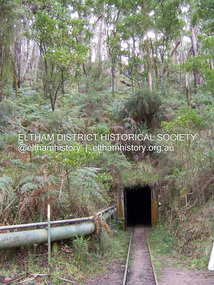 Eltham District Historical Society Inc
Photograph - Digital Photograph, Marguerite Marshall, One Tree Hill Mine, Smiths Gully, 8 June 2006
... Gold transformed the quiet districts, with a constant flow of families and vehicles on the dirt tracks en route to the Caledonia Diggings. Three thousand people worked the gullies in Market Square, including about 1000 Chinese miners. The square established its own police, mining warden, gold battery, school, shops and cemetery and grog flowed. Market Square flourished until the middle 1860s. Bullocks transported quartz from the Caledonia Goldfields to the crushing machinery at the Queenstown/St Andrews Battery, near Smiths Gully Cemetery. It was destroyed by bushfire in 1962. By the late 1850s, most early alluvial fields...Gold transformed the quiet districts, with a constant flow of families and vehicles on the dirt tracks en route to the Caledonia Diggings. Three thousand people worked the gullies in Market Square, including about 1000 Chinese miners. The square established its own police, mining warden, gold battery, school, shops and cemetery and grog flowed. Market Square flourished until the middle 1860s. Bullocks transported quartz from the Caledonia Goldfields to the crushing machinery at the Queenstown/St Andrews Battery, near Smiths Gully Cemetery. It was destroyed by bushfire in 1962. By the late 1850s, most early alluvial fields ...Gold was discovered on One Tree Hill in 1854. The site has been worked intermittently until fairly recent times. Published: Nillumbik Now and Then / Marguerite Marshall 2008; photographs Alan King with Marguerite Marshall.; p53 Though still a working mine, One Tree Hill Mine at Smiths Gully, now stands in a tranquil reserve surrounded by bush and native animals - in contrast to its heyday. In the mid 19th century, when the mine was part of the Caledonia Goldfields, hundreds of men in search of their fortune worked the alluvial gold in the Yarra River, its tributaries and the reefs that made up the goldfields. Miner Stan Bone, assisted by Wilfred Haywood, is the last of the independent gold miners in the area and still uses the quartz crushing battery as miners did when gold was first discovered in the area in 1851.1 Stan, who is the last of six generations of miners in his family, was aged 17 when he began mining on his father Alex’ mine, The Golden Crown in Yarrambat. These days, after blasting the gold-bearing rock in Mystery Reef, one of the four reefs at One Tree Hill, Stan transports it around five kilometres by tip truck to the Black Cameron Mine for crushing. There he uses water from the waterlogged mine, (which still contains gold), as the Happy Valley Creek at One Tree Hill is usually dry.2 The One Tree Hill Mine has been worked for close to a century since it opened around the late 1850s.3 The Swedish Reef was its most productive reef and one of the largest in the area. Around 1859, extractions included 204 ounces (5.8kg) of gold, won from 57 pounds (26kg) of stone.4 Then during World War Two, Stan’s uncle, Bill Wallace, and Alex Bone, closed the mine. In 1973, Stan, with his Uncle Bill, reopened the Black Cameron Mine and worked there until 1988. Stan resumed mining One Tree Hill in 1998. As late as the 1920s gold was picked up by chance! When crossing a gully on his way to vote at the St Andrews Primary School, Bill Joyce picked up some quartz containing gold. This site was to become the Black Cameron Mine. The Caledonia Diggings, named after Scotland’s ancient name by local Scots, began around Market Square (now Smiths Gully) and included Queenstown (St Andrews), Kingstown (Panton Hill) and Diamond Creek. There were also poorer bearing fields in Kangaroo Ground and Swipers Gully (now Research). * None of these compared in riches to the Ballarat and Bendigo fields5, but the Caledonia Diggings continued intermittently for close to 100 years. Gold was discovered in Victoria following a bid to stem the disappearance of much needed workmen to the New South Wales diggings. Several businessmen offered a reward of £200, for the discovery of gold within 200 miles (322 km) of Melbourne. Late in June 1851, gold was first discovered at Andersons Creek, Warrandyte. Then in 1854, George Boston and two other men discovered gold at Smiths Gully. Gold transformed the quiet districts, with a constant flow of families and vehicles on the dirt tracks en route to the Caledonia Diggings. Three thousand people worked the gullies in Market Square, including about 1000 Chinese miners. The square established its own police, mining warden, gold battery, school, shops and cemetery and grog flowed. Market Square flourished until the middle 1860s. Bullocks transported quartz from the Caledonia Goldfields to the crushing machinery at the Queenstown/St Andrews Battery, near Smiths Gully Cemetery. It was destroyed by bushfire in 1962. By the late 1850s, most early alluvial fields were in decline, but minor rushes continued until around 1900 and some until the early 1940s. Some miners did well, although most earned little from their hard labour in the harsh and primitive conditions.6 But according to historian, Mick Woiwod, the gold fields helped to democratise society, as individuals from all walks of life were forced to share experiences, and the ability to succeed, depended less on inherited wealth or social rank.This collection of almost 130 photos about places and people within the Shire of Nillumbik, an urban and rural municipality in Melbourne's north, contributes to an understanding of the history of the Shire. Published in 2008 immediately prior to the Black Saturday bushfires of February 7, 2009, it documents sites that were impacted, and in some cases destroyed by the fires. It includes photographs taken especially for the publication, creating a unique time capsule representing the Shire in the early 21st century. It remains the most recent comprehenesive publication devoted to the Shire's history connecting local residents to the past. nillumbik now and then (marshall-king) collection, gold mining, one tree hill mine, smiths gully -
 Bendigo Historical Society Inc.
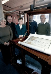
Photograph - 1853 Bendigo Goldfields Petition, abt 1990-2019
... gold fields, particularly during July and August of 1853, directed against the payment of what the miners called a tax - a licence fee of thirty shillings ($3) a month for the right to search for gold on what was declared Crown land. They had to pay the licence whether they found gold or not. The miners, or diggers as they were called, also resented the means used by the authorities at the time to collect the gold licence - through so-called 'digger hunts'. The miners were expected to carry their licences with them, and the police...gold fields, particularly during July and August of 1853, directed against the payment of what the miners called a tax - a licence fee of thirty shillings ($3) a month for the right to search for gold on what was declared Crown land. They had to pay the licence whether they found gold or not. The miners, or diggers as they were called, also resented the means used by the authorities at the time to collect the gold licence - through so-called 'digger hunts'. The miners were expected to carry their licences with them, and the police ...The Red Ribbon Movement of 1853 represented a significant series of events in the history of Bendigo. During that year there was much agitation on the Bendigo gold fields, particularly during July and August of 1853, directed against the payment of what the miners called a tax - a licence fee of thirty shillings ($3) a month for the right to search for gold on what was declared Crown land. They had to pay the licence whether they found gold or not. The miners, or diggers as they were called, also resented the means used by the authorities at the time to collect the gold licence - through so-called 'digger hunts'. The miners were expected to carry their licences with them, and the police, who were often untrained, used harsh methods to check these licences. In Bendigo, the miners took to wearing a red ribbon ‘as a symbol of their protest against the licence. Red was a very common colour in items such as shirts, so was readily available. Shopkeepers too tied red ribbons to their premises as a sign of support for the miners. It should be remembered at that time virtually everyone was a miner. The diggers also had their own banner, designed by William Dexter, a china painter from Devon. This flag showed the pick, shovel and cradle representing labour, the scales representing justice, the Roman bundle of sticks meaning unity and the kangaroo and emu of Australia Many thousands of Bendigo miners signed a petition to La Trobe, the Governor of Victoria, protesting against the licence fee. When the Governor rejected the petition, thousands of diggers marched in peaceful protest. Miners from White Hills, Eaglehawk, Golden Square, Kangaroo Flat as well as from Bendigo Flat, converged on what is now Pall Mall and View Point, surrounding the ~government camp on Camp Hill. The camp had been reinforced with soldiers of the 40 Regiment, as the Government feared bloodshed. The miners then gathered on the hill behind View Point to hear from their leaders - among them George Thomson, Captain Harrison, Captain Brown and W.D.C. Denovan. They resolved to pay a token fee often shillings ($1) for the September licence, whenthey met with Commissioners Panton and Wright on Camp Hill. Although Wright and Panton were sympathetic to the miners, the offer was rejected, but no licence fees were collected for September. Thus a possible bloody conflict was averted by the common sense shown by the miners' leaders and the commissioners. It was a truly democratic protest against arbitrary government and preceded the Eureka Stockade Incident by over a year. Bendigo Historical Society Committee on a Tram, two photos, one of five people standing behind a display cabinet, and the second one a Banner stretched across the tram. On the rear of the photo is "L-R Jim Evans, Terry Davidson, Ron Monro." Second from left is Jim Evans (President) and fourth from the left is Terry Davidson, with extreme right, Ron Munro (Vice President). In the cabinet is the 1853 Bendigo Goldfields Petition (Red Ribbon Rebellion) The society holds the petition in digital form. The diggers had their own banner, designed by William Dexter, a china painter from Devon. This flag showed the pick, shovel and cradle representing labour, the scales representing justice, the Roman bundle of sticks meaning unity and the kangaroo and emu of Australia history, bendigo, tram, 1853 bendigo goldfields petition, red ribbon rebellions -
 Bendigo Historical Society Inc.
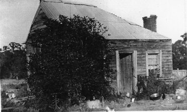
Document - COSTERFIELD: A HISTORY FROM 1853 TO 1978
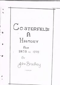
... GOLD Goldfields Costerfield Costerfield Mines Coster Family Field Family Post Office Cemetery Football Boarding houses Blacksmith Hotels and Shops. Brown's Mine Tavern Big Antimony Mine. John Bradley ''COSTERFIELD: A HISTORY FROM 1853 TO 1978'' - PAPER BY JOHN BRADLEY A Paper for History Dip II (where?). 22 handwritten pages with additional pages of photographs. Includes mining history of North Costerfield and South Costerfield Mines; information on Coster family and Field family; coach services to Costerfield; Post Office services; schools in Costerfield; churches at Costerfield; (Indian) hawkers; shops and hotels; boarding houses; blacksmiths; Police in Costerfield; Scheelite mine; Sport; Costerfield Band; Public halls; Cemetery; farmers of the area. ...''COSTERFIELD: A HISTORY FROM 1853 TO 1978'' - PAPER BY JOHN BRADLEY A Paper for History Dip II (where?). 22 handwritten pages with additional pages of photographs. Includes mining history of North Costerfield and South Costerfield Mines; information on Coster family and Field family; coach services to Costerfield; Post Office services; schools in Costerfield; churches at Costerfield; (Indian) hawkers; shops and hotels; boarding houses; blacksmiths; Police in Costerfield; Scheelite mine; Sport; Costerfield Band; Public halls; Cemetery; farmers of the area. Page of acknowledgements; Bibliography; Reproduction (poor) of photographs of early photograph of Costerfield (1890); miners at 'Big Antimony Mine , 1912'; Bombay Mine; various buildings; football club membership 'tickets'; auction advertisement - mining plant, 1902; sale of mining equipment 1941; engine room at the Costerfield Mine 1939; race between motorbike and horse and jinker; school photo - various years 1910-1914; football teams; sketches of public hall and Brown's Mine Tavern (and Billiard Rooms).John Bradleygold, goldfields, costerfield, costerfield mines, coster family, field family, post office, cemetery, football, boarding houses, blacksmith, hotels and shops. brown's mine tavern, big antimony mine. -
 Bendigo Historical Society Inc.
Document - DRAFT ARTICLES FOR RHSV (BENDIGO) NEWSLETTER, MAY 1972
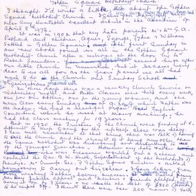
... Names listed of officers of the 40th Foot (Captain's detachment); Location of two cemeteries; Municipal Council of 1858 - Chairman and councillors and meeting times and place; Police Department - names listed of officers of department, Sandhurst Municipality, 'The District' and Eaglehawk Township (names for the last being only on the handwritten copy); 4. Article (w Perry) ''Australian Aboriginals on the Bendigo Gold Field...Names listed of officers of the 40th Foot (Captain's detachment); Location of two cemeteries; Municipal Council of 1858 - Chairman and councillors and meeting times and place; Police Department - names listed of officers of department, Sandhurst Municipality, 'The District' and Eaglehawk Township (names for the last being only on the handwritten copy); 4. Article (w Perry) ''Australian Aboriginals on the Bendigo Gold Field ...Draft articles for RHSV (Bendigo) Newsletter, May 1972. 1. ''Golden Square Methodist Church'' by Lydia Chancellor - memories of church services, Sunday School and Bible classes. Mention of (Minister?) Mr Robert Saunders. Also - Rev B W Heath; Mr Crump, Rev Henry Worrall; reference to Jubilee of church in 1923. 2. Article submitted by Mrs E M Checcucci re the 'White Works' (clothing factory making underwear at the top of Wattle Street) - visited by Prince of Wales in 1920; 3. Handwritten and typewritten version of ''Extracts from the 'Sandhurst Library Almanac 1858', published by P M Sparkes, Bookseller and Stationer (four doors from Shamrock Hotel). Names listed of officers of the 40th Foot (Captain's detachment); Location of two cemeteries; Municipal Council of 1858 - Chairman and councillors and meeting times and place; Police Department - names listed of officers of department, Sandhurst Municipality, 'The District' and Eaglehawk Township (names for the last being only on the handwritten copy); 4. Article (w Perry) ''Australian Aboriginals on the Bendigo Gold Field’’ reference to ''King Charlie'' and finding of gold by him (reference to this in the Bendigo Advertiser 1856 & 1857). The gold purchased by a Mr Bannerman; 5. Article on introduction of gas in Bendigo (by I Hendry). Ref to ''Spotlight'' article in Advertiser of Oct 13, 1950. Mention of Mr Dondy (first user of gas in Bendigo); early use and price of gar; poor gas pressure in Eaglehawk; 6. Handwritten article submitted by John O'C Hattam re 'Indian Hawkers in Bendigo': with request to members to join him in further researching this interesting project; mention of accommodation in Hopetoun Street in terrace houses of the same design as Specimen Cottage (''now occupied by ' Glover??? Mills - but referred to in printed Newsletter of April/May 1972 as ''a site occupied by a clothing factory''); mention of hawkers by name - Rajah Singh, Mahonett Betth, Mahonett Shang, Rajah Bouth, Mahoety Bux, Abdul Rahman (last hawker)document, names of bendigo pioneers, bendigo advertiser -
 Federation University Historical Collection
Map, Ballaarat Gold Field, 1861, 1861
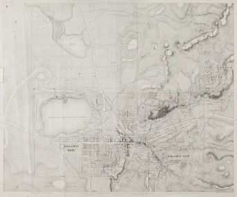
... gold field 1861...yuille's swamp...wendouree swamp...little bendigo diggings...gold leads...old post office hill...specimen hill...bakery hill...black hill...dead horse creek...brown hill...pennyweight hill...clayton hill...soldiers hill...golden point...gum tree flat...white flat...poverty hill...chinese village...robert brough smyth...Ballarat map 1861...Ballaarat Vineyard...Dead Horse Gully...Deadhorse Creek...Invermay...Black Hill Flat...Gaelic Church...Police...In November 2004 the Central Highlands Regional Library presented a special edition of 200 copies of the 1861 map reproduced from a copy in their collection. ballarat map ballarat east lake wendouree survey mines robert davidson ballarat gold field 1861 yuille's swamp wendouree swamp little bendigo diggings gold leads old post office hill specimen hill bakery hill black hill dead horse creek brown hill pennyweight hill clayton hill soldiers hill golden point gum tree flat white flat poverty hill chinese village robert brough smyth Ballarat map 1861 Ballaarat Vineyard Dead Horse Gully Deadhorse Creek Invermay Black Hill Flat Gaelic Church Police Reserve Magpie Range Dalton's Flat Caadian Lead Rifle Butts Powder Magazine Bathing House Government Camp Gold Office Chinese Llanberrris Victoria Theatre Charlie Napier Hotel United States Hotel Grape's Hoel Clayton's Hill Cattleyard Hill Free Trade Hotel Esmond Lead Bakery Hill Black Hill Lead Juvenile Reformatory Ballarat Orphanage Lady Barkly Lead Triffet's Slaughter Yard Little Bendigo Melbourne Road T. ...A party of surveyors camped by Yuille's Swamp (later Lake Wendouree) and surveyed the countryside for a map to be produced by the Geological Survey of Victoria. In November 2004 the Central Highlands Regional Library presented a special edition of 200 copies of the 1861 map reproduced from a copy in their collection. Original 1861 map of Ballarat showing streets and leads. Blue dots indicate gold leads, and red lines indicate auriferous quartz reef and outcrops of quartz veins."Compiled & Drawn from the Survey of Mining Surveyors Davidson, Fitzpatrick and Cowan & the Plans in the Surveyor General's Office by J. Brahe, 21st October 1861. R. Brough Smyth, Secretary for Mines. The Honourable J.B. Humffray, M.L.A. Commr of Mines.”ballarat, map, ballarat east, lake wendouree, survey, mines, robert davidson, ballarat gold field 1861, yuille's swamp, wendouree swamp, little bendigo diggings, gold leads, old post office hill, specimen hill, bakery hill, black hill, dead horse creek, brown hill, pennyweight hill, clayton hill, soldiers hill, golden point, gum tree flat, white flat, poverty hill, chinese village, robert brough smyth, ballarat map 1861, ballaarat vineyard, dead horse gully, deadhorse creek, invermay, black hill flat, gaelic church, police reserve, magpie range, dalton's flat, caadian lead, rifle butts, powder magazine, bathing house, government camp, gold office, chinese, llanberrris, victoria theatre, charlie napier hotel, united states hotel, grape's hoel, clayton's hill, cattleyard hill, free trade hotel, esmond lead, bakery hill, black hill lead, juvenile reformatory, ballarat orphanage, lady barkly lead, triffet's slaughter yard, little bendigo, melbourne road, t. cowan, thomas cowan -
 Federation University Historical Collection
Map, Ballarat Goldfield, c1898
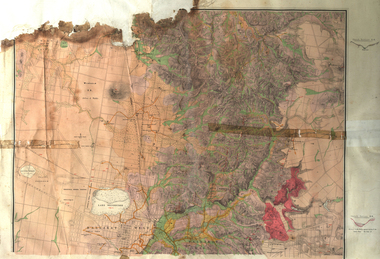
... police paddock...mount rowan...ballarat industrial school reserve...market reserve...Winter's swamp...Kneeshar Co...Monte Cristo line of reef...Chinaman's Gully or Black Snake...Milkmaid's Gully...Ballarat gold field...The Ballarat Industrial School ran from 1869-1879, but the term Ballarat Industrial School Reserve was still in use in 1898 and possibly beyond. ballarat warrenheip lake wendouree ballarat east winters swamp winter swamp wyndholm premptive right cemetery vale park reserve little bendigo kneeshaw co. industrial school reserve kirks dam pincotts dam black hill wombat hill dead horse gully miners rest mt rowan salton and waldie rose hill co great north west no 1 rose's freehold co hand and band co police reserve police paddock mount rowan ballarat industrial school reserve market reserve Winter's swamp Kneeshar Co Monte Cristo line of reef Chinaman's Gully or Black Snake Milkmaid's Gully Ballarat gold field Bakery Hil Lead Old gravel pits lead Golden point lead Eureka Lead Miner's Rest Yarrowee Creek Leigh Creek Black Swamp Lead Yorkshire Reef Nil Desperandum reef Cockatoo Lead HIt or Miss Gully herbert werner frederick de nully Pennyweight Hill Esmond's Lead Ash's Lead Nightingale Lead John Bull Gully Gladstone Reef Whitehorse reef Petticoat Creek Pincott's Dam Frenchman's Gully Tim's Crushing Plant Jenkin's Gully California Gully Drake's Creek Sulton and Waldie Ballarat Undustrial School Ballarat & Mariborough Railway Geological Map of Ballarat with 3 holes in the left hand side. ...This map shows geological features, suggests the last basalt flow, and includes alotments and names of Mining Companies. Although this map has no date on it the Ballarat Industrial School is used for dating purposed. The Ballarat Industrial School ran from 1869-1879, but the term Ballarat Industrial School Reserve was still in use in 1898 and possibly beyond.Geological Map of Ballarat with 3 holes in the left hand side. The map indicates the position of Lake Wendouree, Township of Warrenheip, Ballarat East, Industrial School Reserve, Winters Swamp, Police Paddock, Wyndholm Premptive Right (Salton and Waldie), Black Hill, Vale Park Reserve, Pennyweight Hill, Little Bendigo, Black Swamp Lead, monte Christo Reef, Chinaman's Gully, Miners Rest, Pincotts Dam, Northumberland Gully. It also show the following goldmining companies: City of Ballarat, Kohinor, Hand and Band, Great North West, Northern Junction, Kneeshaw, Rossers Freehold, Silurial.ballarat, warrenheip, lake wendouree, ballarat east, winters swamp, winter swamp, wyndholm premptive right, cemetery, vale park reserve, little bendigo, kneeshaw co., industrial school reserve, kirks dam, pincotts dam, black hill, wombat hill, dead horse gully, miners rest, mt rowan, salton and waldie, rose hill co, great north west no 1, rose's freehold co, hand and band co, police reserve, police paddock, mount rowan, ballarat industrial school reserve, market reserve, winter's swamp, kneeshar co, monte cristo line of reef, chinaman's gully or black snake, milkmaid's gully, ballarat gold field, bakery hil lead, old gravel pits lead, golden point lead, eureka lead, miner's rest, yarrowee creek, leigh creek, black swamp lead, yorkshire reef, nil desperandum reef, cockatoo lead, hit or miss gully, herbert werner frederick de nully, pennyweight hill, esmond's lead, ash's lead, nightingale lead, john bull gully, gladstone reef, whitehorse reef, petticoat creek, pincott's dam, frenchman's gully, tim's crushing plant, jenkin's gully, california gully, drake's creek, sulton and waldie, ballarat undustrial school, ballarat & mariborough railway -
 Marysville & District Historical Society
Book - Paperback book, The History of Gold Discovery in Victoria, 1979
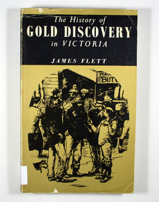
... Marysville & District Historical Society 39 Darwin Street Marysville yarra-valley-and-the-dandenong-ranges A history of gold discovery in Victoria gold gold field gold miner gold mining gold town victoria australia history Stamp of the Marysville & District Historical Society Inc / P.O. Box 22 / Marysville 3779 Paperback. Gold front cover. Front cover has a drawing of a group of miners outside a shop. Back cover has a drawing of a group of mounted police ...A history of gold discovery in VictoriaPaperback. Gold front cover. Front cover has a drawing of a group of miners outside a shop. Back cover has a drawing of a group of mounted police riding roughshod through a group of people and dogs.Stamp of the Marysville & District Historical Society Inc / P.O. Box 22 / Marysville 3779gold, gold field, gold miner, gold mining, gold town, victoria, australia, history -
 Stawell Historical Society Inc
Photograph, Four Posts Inn in Glenorchy -- Building no longer exists
... The Four post Inn was a "Staging Camp" for the police escort route during the transportation of gold by road from Mount Alexander gold fields (Bendigo) to Adelaide South Australia in 1852-53. ...The Four post Inn was a "Staging Camp" for the police escort route during the transportation of gold by road from Mount Alexander gold fields (Bendigo) to Adelaide South Australia in 1852-53. ...Four Posts Inn. Glenorchy built about 1841 by John Gleeson on the Wimmera River at Glenorchy. Building no longer exists as burnt down in 1944. Located on the site now known as Glenorchy (Victoria). Glenorchy is approximately 20Km from the former Ashen's pastoral run occupied by Dugald McPherson. The Four post Inn was a "Staging Camp" for the police escort route during the transportation of gold by road from Mount Alexander gold fields (Bendigo) to Adelaide South Australia in 1852-53. The police escort is known to have called in at Ashens homestead to visit Dugald McPherson. The Four Post Inn was the scene on the occasion of and encounter between the police escort and bushrangers. At a later date The Four Post Inn was a staging camp for the horse drawn coach service between Stawell and Horsham.Small weatherboard building with no verandah and tree blocking the view. Cat in front of doorway.stawell -
 Sunbury Family History and Heritage Society Inc.
Photograph, Bill Walls, Gap Gaol, c1970s
... gold fields. In the 1990s the building was taken down brick by brick and rebuilt in the front of the Sunbury Police Station in Macedon Street....gold fields. In the 1990s the building was taken down brick by brick and rebuilt in the front of the Sunbury Police Station in Macedon Street. ...Bill Walls is the artist who did the original watercolour of the small building, that was originally a gaol sited at The Gap settlement. The Gap, on the Calder Highway, preceded Sunbury's settlement and the gaol was used during the 1850s gold rush era, when the precious metal was being brought to Melbourne from the gold fields. In the 1990s the building was taken down brick by brick and rebuilt in the front of the Sunbury Police Station in Macedon Street.The Gap gaol building played a significant role in the development of the local area and is of local heritage significance.A photograph of a coloured watercolour of a small bluestone building with a stone chimney and a corrugated iron roof. the gap, police station, the gap gaol, gold rushes, sunbury -
 Bendigo Historical Society Inc.
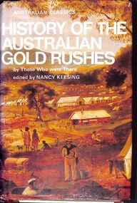
Book - "History of the Australian Gold Rushes", 1971
... gold' near Bathurst in 1851. This discovery sparked off what was to become the most exciting, and perhaps chaotic, period in Australian History. Gathered in the book are over 120 eye-witness accounts of those turbulent years between 1851 and 1890 - the 'finds', terrible privations in the diggers' camps, police brutality, riots, and courage on the gold fields. ...gold' near Bathurst in 1851. This discovery sparked off what was to become the most exciting, and perhaps chaotic, period in Australian History. Gathered in the book are over 120 eye-witness accounts of those turbulent years between 1851 and 1890 - the 'finds', terrible privations in the diggers' camps, police brutality, riots, and courage on the gold fields. ...The discovery of gold in the 1850s started a series of rushes that transformed the Australian colonies. The first discoveries of payable gold were at Ophir in New South Wales and then at Ballarat and Bendigo Creek in Victoria. In 1851 gold-seekers from around the world began pouring into the colonies, changing the course of Australian history. The gold rushes greatly expanded Australia’s population, boosted its economy, and led to the emergence of a new national identity. Edward Hammond Hargraves found himself 'surrounded by gold' near Bathurst in 1851. This discovery sparked off what was to become the most exciting, and perhaps chaotic, period in Australian History. Gathered in the book are over 120 eye-witness accounts of those turbulent years between 1851 and 1890 - the 'finds', terrible privations in the diggers' camps, police brutality, riots, and courage on the gold fields. This book also touches on the 'Eureka Stockade', bushrangers, identities such as Lola Montez, and 'Lasseter's Reef'. "History of The Australian Gold Rushes" published by Lloyd O'Neil Pty. Edited by Nancy Keesing. Introduction by Nancy Keesing. Published in 1971. Hard cover book which is colored maroon. Publisher and title written in gold lettering on spine. Dust jacket has image of early town with buildings and people in foreground - front and back cover. Title and editor's name in white text. Printed in Hong Kong. 412 pp. Contains both text and black and white images. Has index. australian gold, miners, gold fields, gold