Showing 19 items matching " governor burke"
-
 Bendigo Historical Society Inc.
Document - MAJOR MITCHELL AND MOUNT ALEXANDER
... ... Governor Burke...History House 11 Mackenzie Street Bendigo goldfields DOCUMENT Major Mitchell and Mount Alexander Tommy-Came-Last The Major Mitchell Tourist Trail Major General John Byng Phillip of Macedonia Alexander the Great Henty s Surveyor Davidson Alexander Mollison George Augustus Robinson William Morton Mr Charles Hotson Ebden John Randell Public Library of Melbourne Les Blake Governor Burke Phillip Parker King Crown Solicitor Henry Field Gurner Arthur Phillip Hume Australia Felix Expedition L Blake Place Names of Victoria G Brenmer Booklet for Secondary Schools M Cannon Historical Records of Victoria Vol 1 J H L Cumpston Thomas Mitchell Surveyor General and Explorer H F Gurner Chronicle of Port Phillip T L Mitchell Three Expeditions into the Interior of Eastern Australia A F Mollison An Overlanding Diary W L Morton Adventures of a Pioneer M S 5188 Itinerary from the Journal of the Exploring Expedition returning from Portland Bay M S 5189 Mitchell's 1837 Map J O Randell Pastoral Settlement in Northern Victoria Vol 1 Pastoral Settlement in Northern Victoria Vol 2 Records of the Victorian Archaeological Survey Number 5 Journals of George Augustus Robinson T C Sargent Some Peninsular Names in Australia Felix W H Wells A Geographical Dictionary or Gazetteer of the Australian Colonies Typed notes mentioning the naming of Mount Alexander, Coliban, Campaspe and who named them. ...Typed notes mentioning the naming of Mount Alexander, Coliban, Campaspe and who named them. Also the origins of the names.document, major mitchell and mount alexander, tommy-came-last, the major mitchell tourist trail, major general john byng, phillip of macedonia, alexander the great, henty s, surveyor davidson, alexander mollison, george augustus robinson, william morton, mr charles hotson ebden, john randell, public library of melbourne, les blake, governor burke, phillip parker king, crown solicitor henry field gurner, arthur phillip, hume, australia felix expedition, l blake, place names of victoria, g brenmer, booklet for secondary schools, m cannon, historical records of victoria vol 1, j h l cumpston, thomas mitchell surveyor general and explorer, h f gurner, chronicle of port phillip, t l mitchell, three expeditions into the interior of eastern australia, a f mollison, an overlanding diary, w l morton, adventures of a pioneer, m s 5188, itinerary from the journal of the exploring expedition returning from portland bay, m s 5189, mitchell's 1837 map, j o randell, pastoral settlement in northern victoria vol 1, pastoral settlement in northern victoria vol 2, records of the victorian archaeological survey number 5, journals of george augustus robinson, t c sargent, some peninsular names in australia felix, w h wells, a geographical dictionary or gazetteer of the australian colonies -
 Warrnambool and District Historical Society Inc.
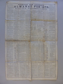
Document, News Sheet Almanac for 1870, 1870
... This Almanac records the many various organisations, such as churches schools councils and law related information.It lists public holidays, members of Parliament as well as births and deaths natural events such as rainfall, sunrise/sunsets and moon charts. it records mail charges and coach timetables.A middle section presents a calendar for 1870 with a record of events which were deemed important since the time of settlement It lists such things as the first telegram from Melbourne to Sydney1858, Governor Bligh deposed 1808, Burke and Wills funeral 1863. ...Warrnambool and District Historical Society Inc. 2 Gilles Street (south of Merri St) Warrnambool great-ocean-road This Almanac records the many various organisations, such as churches schools councils and law related information.It lists public holidays, members of Parliament as well as births and deaths natural events such as rainfall, sunrise/sunsets and moon charts. it records mail charges and coach timetables.A middle section presents a calendar for 1870 with a record of events which were deemed important since the time of settlement It lists such things as the first telegram from Melbourne to Sydney1858, Governor Bligh deposed 1808, Burke and Wills funeral 1863. ...This Almanac records the many various organisations, such as churches schools councils and law related information.It lists public holidays, members of Parliament as well as births and deaths natural events such as rainfall, sunrise/sunsets and moon charts. it records mail charges and coach timetables.A middle section presents a calendar for 1870 with a record of events which were deemed important since the time of settlement It lists such things as the first telegram from Melbourne to Sydney1858, Governor Bligh deposed 1808, Burke and Wills funeral 1863. At the bottom of the page is a Warrnambool Business Directory which includes J S Rowley Corio brewery, Royal Hotel , J H Rule Painter, plumber and glazier, J Brady , tinsmith and A Lanagan , Golden Boot The Warrnambool Examiner was founded by John Wilkinson and Richard Osburne in 1851. After a gap of a couple of years Richard Osburne resumed publication in October 1853 and continued until 1867. William Fairfax and Henry Laurie then leased the paper (1867 to 1872) before Richard Osburne again became the proprietor from October 1872 to April 1878 and from December 1879 to December 1880 when publication ceased. Fairfax and Laurie were the proprietors of the paper when this Almanac was published. William Fairfax was a member of the Fairfax family which was, and still is, associated with the publication of many Australian newspapers. Henry Laurie later became well-known as a Melbourne University Philosophy Professor.This single sheet of newspaper is an interesting and valuable record of Warrnambool and its people in 1870. There are names of many local people recorded and it also gives an insight into the variety of businesses and orhganisations which were established by 1870. It is also interesting to note that there are at least ten different styles of print on the page.Large single broadsheet of newspaper with large black heading and eight columns of print. The back of the page is blank.Fairfax and Laurie's Almanac for 1870 presented with the Warrnambool Examiner. Published as a supplement to the Warrnambool Examiner of 7th January 1870 Vol.XX No 1597.warrnambool, warrnambool almanac 1870,, examiner almanac warrnambool, fairfax and laurie, examiner warrnambool -
 The Beechworth Burke Museum
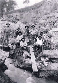
Photograph - Photograph - Reproduction, W. D. Gibbon, Early 1900s
... Burke Museum Loch Street Beechworth high-country This photograph was taken in 1911 at Three Mile Creek, about five kilometers south of Beechworth town. Significant digging took place at this location from late 1855, which led to a flood of workers and stores to follow, though daily earnings were slim compared to the nearby Woolshed site. This remained the case even after workers at Three Mile Creek attempted to protest around Beechworth during an election in November 1855. Three Mile Creek was one of seven significant divisions of the Beechworth Mining District formalised by the Governor ...This photograph was taken in 1911 at Three Mile Creek, about five kilometers south of Beechworth town. Significant digging took place at this location from late 1855, which led to a flood of workers and stores to follow, though daily earnings were slim compared to the nearby Woolshed site. This remained the case even after workers at Three Mile Creek attempted to protest around Beechworth during an election in November 1855. Three Mile Creek was one of seven significant divisions of the Beechworth Mining District formalised by the Governor-in-Council in 1858, though by the time this photograph was taken, the boundaries of the original seven districts had shifted to create seventeen divisions. The Three Mile Goldfields was a site of rich alluvial gold deposits located about 5km south of Beechworth in Victoria. Today, the location of this gold deposit is called Baarmutha. It was a popular area for gold mining in the 1850s but became largely abandoned by the following decade. In 1865, a man named John Pund (a man second from the left in the back row of this photograph shares this surname) recognized that the area could be potentially rich if a better water supply could be obtained. He secured a 15 year license with three other miners. Within the next five years, these men had constructed 19 km of water race going from Upper Nine Mile Creek to Three Mile Creek. By 1881, these four men had delivered 950,000 gallons to the Three Mile Sluicing area which is depicted in this photograph. Pund would later go into partnership with John Alston Wallace who would become owner of the Star Hotel in Beechworth. The Three Mile sluicing location continued to be operational until 1950. The eleven miners in this photograph are: Back row: Led Guthrie, P. Pund, F. Beel, [Unknown] Miller Front row: Paddy McNamara, J. King, W. Beel, [Unknown] Garland, J. Clarke, J. Ryan, H. Bartsh In the background of the photograph is a huge dirt wall that appears to suffer damage caused by hydraulic sluicing. Hydraulic sluicing is a specialised mining technique that involves directing high pressure water flows at dirt to uncover gold. The technique played a significant role in shaping Beechworth's landscape during the gold rush to create the topography seen today.The search for gold is ingrained into the history of Victoria and therefore, images like this one which portray an open cut sluicing site can reveal important information for society and technology for the date when the photograph was taken. This image is of important historical significance for its ability to convey information about sluicing and the methods used to find gold in the late 1800s and early 1900s. It also shows a location where sluicing was undertook which provides insight into the impact of sluicing on the environment at a time when it was done. Images, like this one, of Australian gold rush history can reveal important information about the social and environmental impact of this period. This image depicts diggers standing in a mining location and therefore, this image has the capacity to reveal or support significant information for researchers studying the fashion and social status of diggers in Australia in approximately 1911. It can also provide information on the landscape of Australia in this period and the impact of mining for gold on both society and the Australian landscape. The Burke Museum is home to a substantial collection of Australian mining photographs which can be used to gain a deeper understanding into life on the gold fields, technology used in mining, the miners themselves and the impact of the gold digging on the environment.Black and white / sepia rectangular reproduced photograph printed on glossy photographic paper mounted on board.beechworth, beechworth museum, mining, mining team, three mile creek, sluicing, hydraulic sluicing, photography, gold sluicing, gold mining, pund mining -
 The Beechworth Burke Museum
Photograph, 2000
... burke museum...school...education...trees...nature...state school...woolshed...gold mining...teachers...over time...Owens and Murray advertiser...public meetings...public dance...c. o'donoghue...spring creek...state governor...The image is also useful for prompting discussion about how Beechworth has changed over time, with the photograph taken 78 years after the school closed down. beechworth burke museum school education trees nature state school woolshed gold mining teachers over time Owens and Murray advertiser public meetings public dance c. o'donoghue spring creek state governor Sir Reginald Talbot miners honour roll world war 1 Woolshed State. / School site / 2000 / - remnant trees / / co A colour rectangular photograph printed on glossy photographic paper. ...Woolshed is a small area about five kilometres north west of Beechworth, and almost about 225km north east of Melbourne. When gold was discovered at the nearby Spring Creek in February 1852, Woolshed was one of three settlements set up to house miners and their families. At its peak in 1857, Woolshed was also populated by 29 storekeepers and 14 hotels, as well as the Woolshed State School, which stood near where this photograph was taken. The school often played host to public meetings, as well as a public dance in 1897. The school was subject to some controversy in 1874 when one parent complained about the head of the school in the local newspaper, the Owens and Murray Advertiser, and at least three letters to the editor were exchanged between the two. According to the parent, C. O'Donoghue was not providing enough amusement for the children and was disrespectful to parents and staff. When the State Governor, Sir Reginald Talbot, visited Beechworth in 1906, the school organised a celebratory welcome. The Woolshed State School was ultimately closed in 1922 as miners had exhausted the Spring Creek gold supply and were moving elsewhere. This photograph, taken in about 2000, shows the trees that grew on or near the site of the original school. The Woolshed State School Honour Roll, with a list of the men from the school who served in the First World War, also still exists. It is stored in the Beechworth RSL as of 2015.This photograph is significant for its connection to an important site in Beechworth's gold mining history. Woolshed served a significant community of miners, with a population of at least 138 according to the 1911 census, with families that needed the school site to ensure their children's education. The image is also useful for prompting discussion about how Beechworth has changed over time, with the photograph taken 78 years after the school closed down.A colour rectangular photograph printed on glossy photographic paper.Woolshed State. / School site / 2000 / - remnant trees / / cobeechworth, burke museum, school, education, trees, nature, state school, woolshed, gold mining, teachers, over time, owens and murray advertiser, public meetings, public dance, c. o'donoghue, spring creek, state governor, sir reginald talbot, miners, honour roll, world war 1 -
 The Beechworth Burke Museum
Photograph - Photograph - Reproduction, c1965
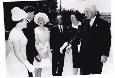
... It may be compared and studied alongside other photographs and objects in the Burke Museum. local government united shire of beechworth sir rohan delacombe Victoria governor Reverse: A02556-2 / A black and white rectangular reproduction photograph printed on paper. ...This photograph depicts the visit of Sir Rohan Delacombe and Lady Delacombe (on right) to Beechworth in 1965. Also present are Shire Secretary Graham Gray and Mrs Gray (left), and Shire President J McCauley and Mrs McCauley, centre. His Excellency Sir Rohan Delacombe (1906–1991) was appointed Governor of Victoria on 8 May 1963 and served until 1974, when he was replaced by the first Australian-born governor, Sir Henry Winneke. Born on 25 October 1906 at St Julians, Malta, Sir Rohan was the second child and only son of Addis Delacombe, a British army pay officer, and his wife Emma Louise Mary, née Leland. The Delacombe family seat was Shrewton Manor, near Salisbury, Wiltshire, and several generations of Delacombes had served in the armed forces. Sir Rohan took up his role in Australia following long and distinguished military and diplomatic career. He is reported to have taken great interest in local events and politics, and at the time this image was taken, he and Lady Delacombe made several appearances as guests of local government representatives at centres around Victoria. This photograph is historically significant for its record of the visit of Sir Rohan and Lady Delacombe at Beechworth in 1965. It may be compared and studied alongside other photographs and objects in the Burke Museum.A black and white rectangular reproduction photograph printed on paper.Reverse: A02556-2 /local government, united shire of beechworth, sir rohan delacombe, victoria governor -
 The Beechworth Burke Museum
Photograph - Lantern Slide, 1901
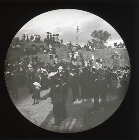
... Burke Museum Collection...Photograph...Monochrome...Queen Victoria Park...Rock...Victoria...Cannons...Isaac isaacs...governor...Burke Museum Beechworth Lantern Slide Slide Glass Slide Plate Burke Museum Collection Photograph Monochrome Queen Victoria Park Rock Victoria Cannons Isaac isaacs governor-general politicians judges indigo shire north-east victoria 19th century nineteenth century parks Thin translucent sheet of glass with a circular image printed on the front and framed in a black backing. ...This glass slide captures the unveiling of the two cannons at Queen Victoria Park which were secured by Sir Isaac Isaacs and presented to Beechworth in 1901. In the foreground, elegantly dressed ladies and dapper gentlemen can be seen gathering around the park's iconic rock, with excited children looking on from the sides. Atop of the rock stands an intricately designed gas lamp that has since been removed but evidence of its existence still remains. The unveiling of these two cannons would have been a celebratory affair for those in attendance, marking a momentous occasion for Beechworth residents that was captured in this lantern slide. Sir Isaac Isaacs was an influential figure in Beechworth, having grown up and studied there. He began his education at the Common school and eventually graduated as dux of the Beechworth Grammar School. His commitment to public service was evident early on and he was elected to the Legislative Assembly in 1892, representing Bogong, a district which included Yackandandah and Beechworth. During his time in office he pushed for better education, healthcare, employment opportunities and housing for the people of Beechworth. Lantern slides, sometimes called 'magic lantern' slides, are glass plates on which an image has been secured for the purpose of projection. Glass slides were etched or hand-painted for this purpose from the Eighteenth Century but the process became more popular and accessible to the public with the development of photographic-emulsion slides used with a 'Magic Lantern' device in the mid-Nineteenth Century. Photographic lantern slides comprise a double-negative emulsion layer (forming a positive image) between thin glass plates that are bound together. A number of processes existed to form and bind the emulsion layer to the base plate, including the albumen, wet plate collodion, gelatine dry plate and woodburytype techniques. Lantern slides and magic lantern technologies are seen as foundational precursors to the development of modern photography and film-making techniques.This glass slide captures social and historical significance as it represents a moment of celebration for Beechworth residents and symbolises an important milestone in the town's history. This lantern slide stands testament to a special moment in Beechworth’s history and its significance continues to be remembered today. It is also an example of an early photographic and film-making technology in use in regional Victoria in the time period.Thin translucent sheet of glass with a circular image printed on the front and framed in a black backing. It is held together by metals strips to secure the edges of the slide. burke museum, beechworth, lantern slide, slide, glass slide, plate, burke museum collection, photograph, monochrome, queen victoria park, rock, victoria, cannons, isaac isaacs, governor-general, politicians, judges, indigo shire, north-east victoria, 19th century, nineteenth century, parks -
 The Beechworth Burke Museum
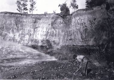
Photograph - Photograph - Reproduction, Unknown c1852-1940
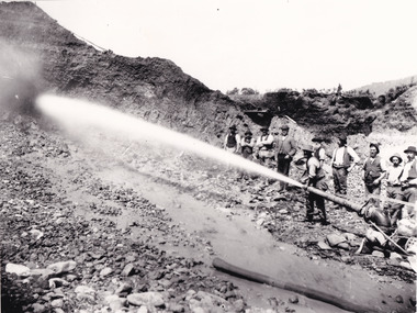
... The Beechworth Burke Museum Loch Street Beechworth high-country Depicted in the photograph are ten miners standing at a cliff face using a high pressure hose, in Beechworth, Victoria. The miners are located in the Three Mile Creek division, in the Beechworth Mining District established January 4th 1858 under An Act for Amending the Laws Relating to the Goldfields by the Governor-in-Council. ...Depicted in the photograph are ten miners standing at a cliff face using a high pressure hose, in Beechworth, Victoria. The miners are located in the Three Mile Creek division, in the Beechworth Mining District established January 4th 1858 under An Act for Amending the Laws Relating to the Goldfields by the Governor-in-Council. The Ovens Gold Rush began at Beechworth in February 1852 and was followed by Yackandandah and the 'Indigo Goldfield'. The strategies applied to mining in Beechworth were distinct in comparison to other goldfields in Victoria such as Bendigo and Ballarat. The miners in Beechworth utlised 'hydraulic sluicing' to remove washdirt, the long water races and deep tailraces constructed through solid rock with an estimated 900 miles of water races cut through the Beechworth fields by 1880, demonstrating great engineering feats. The photograph taken is significant as it is a visual representation of the mining strategy, 'hydraulic sluicing' that was particularly unique to the Beechworth mines, particularly in Victoria and an engineering feat.Black and white rectangular photograph printed on matte photographic paper, unmounted print.beechworth mining district, mining, three mile creek division, three mile creek -
 The Beechworth Burke Museum
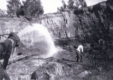
Photograph, c1920
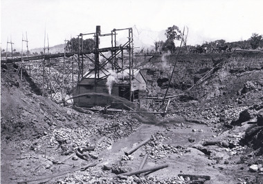
... The Beechworth Burke Museum Loch Street Beechworth high-country This photo shows the large mining cavity with a hydraulic sluicing machine in operation at Baarmutha Three Mile Mine, Beechworth . The Beechworth Mining District was one of six mining districts established by the Governor ...This photo shows the large mining cavity with a hydraulic sluicing machine in operation at Baarmutha Three Mile Mine, Beechworth . The Beechworth Mining District was one of six mining districts established by the Governor-in-Council on 4 January 1858 under the provisions of An Act for Amending the Laws Relating to the Goldfields (21 Vic no.32). The District was further divided into seven divisions: Spring Creek, Snake Valley, Three Mile Creek, Buckland, Woolshed, Yackandandah and Omeo. The boundaries of each of these divisions and of the whole district are described in the Governor-in-Council's proclamation printed in the Government Gazette, 5 January 1858, pages 3-5. Hydraulic mining is a form of mining that uses high-pressure jets of water to dislodge rock material or move sediment. In the placer mining of gold or tin, the resulting water-sediment slurry is directed through sluice boxes to remove the gold. It is also used in mining kaolin and coal.This photograph shows the impact the gold rush era had on Australia and the earth.A black and white rectangular photograph printed on photographic paperCopied from original on loan film (WEBB QLD) / Donated 2009 NOV/ Baarmutha Three Mile Mine c1920-1950/ Managed by John Weir Peter Jereen Jack Cox / Owned by Plain Bros then Parkinsons Sluicing.mining, gold fields, beechworth, gold rush, burke museum, photograph, mining cavity, hydraulic mining, hydraulic sluicing, baarmutha -
 The Beechworth Burke Museum
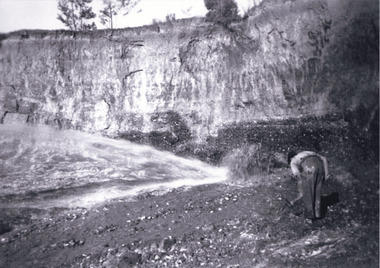
Photograph, Circa 1920 - 1950
... Burke Museum Loch Street Beechworth high-country Taken between circa 1920 - 1950 this photograph depicts a man dressed in dark trousers, a white long sleeved shirt and broad-brimmed workers hat digging around in the Three Mile Mine at Barramutha. The mine was an important gold resource and was typically mined using a method known as hydraulic sluicing whereby high powered water jets are used to dislodge rock or move sediment. The remaining water sediment slurry is directed through sluice boxes to remove the gold. The Beechworth mining district was one of six mining districts established by the governor ...Taken between circa 1920 - 1950 this photograph depicts a man dressed in dark trousers, a white long sleeved shirt and broad-brimmed workers hat digging around in the Three Mile Mine at Barramutha. The mine was an important gold resource and was typically mined using a method known as hydraulic sluicing whereby high powered water jets are used to dislodge rock or move sediment. The remaining water sediment slurry is directed through sluice boxes to remove the gold. The Beechworth mining district was one of six mining districts established by the governor-in-council on 4th of January 1858 under the provisions of An Act for Amending the Laws Relating to the Goldfields (21 Vic no. 32). This photograph shows historic and research value into the historical methods of hydraulic sluicing in the Beechworth mining disctrict. It also shows the evolution of the mining methods and has potential for understanding future engineering endeavors in the context of victorian mine goldfields. Black and white rectangular photograph printed on matte photographic paper.Reverse: 7597.3/ Copied from original on loan from Webb (QLD)/ Donated Nov 2009/ Barnawatha Three Mile Mine 1920-1950/ Owned by Plain Bros then Parkinsons/ Managed by John Weir, Peter Jenson, Jack Cox/ Slicing. three mile creek, three mile goldfields, three mile beechworth, goldfields, #beechworth, hydraulic mining, hydraulic sluice, burke museum -
 The Beechworth Burke Museum
Photograph, 1920 - 1930
... governor-in-council on 4th of January 1858 under the provisions of An Act for Amending the Laws Relating to the Goldfields (21 Vic no. 32). This photograph shows cultural and research value into the historical methods of hydraulic sluicing in the Beechworth mining disctrict. It also shows the evolution of the mining methods and has potential for understanding future engineering endeavors in the context of victorian mine goldfields. three mile creek three mile goldfields three mile beechworth Goldfields #beechworth Hydraulic mining Hydraulic Sluice Burke Museum Reverse: Copied from original on loan from Webb (QLD)/ Donated Nov 2009/ Barnawatha Three Mile Mine c1920-1950/ Owned by Plain Bros then Parkinsons/ Managed by John Weir, Peter Jenson, Jack Cox/ Slicing. ...Taken between circa 1920 - 1930 this photograph depicts a Hydraulic water jet in the foreground and a man dressed in dark trousers, a white long sleeved shirt and broad-brimmed workers hat digging around in the Three Mile Mine at Barramutha. The mine was an important gold resource and was typically mined using a method known as hydraulic sluicing whereby high powered water jets are used to dislodge rock or move sediment. The remaining water sediment slurry is directed through sluice boxes to remove the gold. The Beechworth mining district was one of six mining districts established by the governor-in-council on 4th of January 1858 under the provisions of An Act for Amending the Laws Relating to the Goldfields (21 Vic no. 32).This photograph shows cultural and research value into the historical methods of hydraulic sluicing in the Beechworth mining disctrict. It also shows the evolution of the mining methods and has potential for understanding future engineering endeavors in the context of victorian mine goldfields.Black and White rectangular photograph printed on matte photographic paper. Reverse: Copied from original on loan from Webb (QLD)/ Donated Nov 2009/ Barnawatha Three Mile Mine c1920-1950/ Owned by Plain Bros then Parkinsons/ Managed by John Weir, Peter Jenson, Jack Cox/ Slicing. three mile creek, three mile goldfields, three mile beechworth, goldfields, #beechworth, hydraulic mining, hydraulic sluice, burke museum -
 The Beechworth Burke Museum
Photograph, 1920 - 1930
... Burke Museum Loch Street Beechworth high-country Taken between circa 1920 - 1950 this photograph depicts the open mine in the Three Mile Mine at Barramutha. The mine was an important gold resource and was typically mined using a method known as hydraulic sluicing whereby high powered water jets are used to dislodge rock or move sediment. The remaining water sediment slurry is directed through sluice boxes to remove the gold. The Beechworth mining district was one of six mining districts established by the governor ...Taken between circa 1920 - 1950 this photograph depicts the open mine in the Three Mile Mine at Barramutha. The mine was an important gold resource and was typically mined using a method known as hydraulic sluicing whereby high powered water jets are used to dislodge rock or move sediment. The remaining water sediment slurry is directed through sluice boxes to remove the gold. The Beechworth mining district was one of six mining districts established by the governor-in-council on 4th of January 1858 under the provisions of An Act for Amending the Laws Relating to the Goldfields (21 Vic no. 32).This photograph shows cultural and research value into the historical methods of hydraulic sluicing in the Beechworth mining disctrict. It also shows the evolution of the mining methods and has potential for understanding future engineering endeavors in the context of victorian mine goldfields.Black and White rectangular photograph printed on matte photographic paper.Reverse: Copied from original on loan from Webb (QLD)/ Donated Nov 2009/ Barnawatha Three Mile Mine c1920-1950 Minehead & Slicing/ Managed by John Weir, Peter Jensen, Jack Cox/ Owned by/ the Plain Bros then Parkinsons/ John worked for Pqarkinsons. three mile creek, three mile goldfields, three mile beechworth, goldfields, #beechworth, hydraulic mining, hydraulic sluice, burke museum -
 Bendigo Historical Society Inc.
Document - INVITATION, 1974
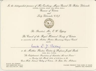
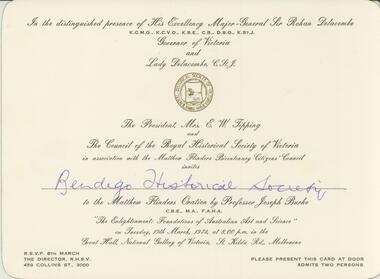
... A large cream coloured card printed with the Royal Historical Society emblem in gold in the upper section and printed with the following words in black script: In the distinguished presence of His Excellency Major-General Sir Rohan Delacombe Governor of Victoria and Lady Delacombe, The President Mrs E W Tipping and the Council of the Royal Historical Society of Victoria in association with the Matthew Flinders Bicentenary Citizens Council invites Miss L J Parry to the Matthew Flinders Oration by Professor Joseph Burke, "The Enlightenment: Foundations of Australian Art and Science" on Tuesday 19 March 1974 at 8:00pm in the Great Hall, National Gallery of Victoria St Kilda Rd Melbourne. ...A large cream coloured card printed with the Royal Historical Society emblem in gold in the upper section and printed with the following words in black script: In the distinguished presence of His Excellency Major-General Sir Rohan Delacombe Governor of Victoria and Lady Delacombe, The President Mrs E W Tipping and the Council of the Royal Historical Society of Victoria in association with the Matthew Flinders Bicentenary Citizens Council invites Miss L J Parry to the Matthew Flinders Oration by Professor Joseph Burke, "The Enlightenment: Foundations of Australian Art and Science" on Tuesday 19 March 1974 at 8:00pm in the Great Hall, National Gallery of Victoria St Kilda Rd Melbourne. ...Official invitation to Miss L J Parry from The Council of the Royal Historical Society of Victoria. A large cream coloured card printed with the Royal Historical Society emblem in gold in the upper section and printed with the following words in black script: In the distinguished presence of His Excellency Major-General Sir Rohan Delacombe Governor of Victoria and Lady Delacombe, The President Mrs E W Tipping and the Council of the Royal Historical Society of Victoria in association with the Matthew Flinders Bicentenary Citizens Council invites Miss L J Parry to the Matthew Flinders Oration by Professor Joseph Burke, "The Enlightenment: Foundations of Australian Art and Science" on Tuesday 19 March 1974 at 8:00pm in the Great Hall, National Gallery of Victoria St Kilda Rd Melbourne. In the lower left hand corner is printed RSVP 8th March The Director RHSV 459 Collins St 3000 and in the lower right hand corner Please present this card at door Admits two persons.event, official -
 Bendigo Historical Society Inc.
Document - INVITATION, 1974
... A large cream coloured card printed with the Royal Historical Society emblem in gold in the upper section and printed with the following words in black script: In the distinguished presence of His Excellency Major-General Sir Rohan Delacombe Governor of Victoria and Lady Delacombe, The President Mrs E W Tipping and the Council of the Royal Historical Society of Victoria in association with the Matthew Flinders Bicentenary Citizens Council invites Bendigo Historical Society to the Matthew Flinders Oration by Professor Joseph Burke, "The Enlightenment: Foundations of Australian Art and Science" on Tuesday 19 March 1974 at 8:00pm in the Great Hall, National Gallery of Victoria St Kilda Rd Melbourne. ...A large cream coloured card printed with the Royal Historical Society emblem in gold in the upper section and printed with the following words in black script: In the distinguished presence of His Excellency Major-General Sir Rohan Delacombe Governor of Victoria and Lady Delacombe, The President Mrs E W Tipping and the Council of the Royal Historical Society of Victoria in association with the Matthew Flinders Bicentenary Citizens Council invites Bendigo Historical Society to the Matthew Flinders Oration by Professor Joseph Burke, "The Enlightenment: Foundations of Australian Art and Science" on Tuesday 19 March 1974 at 8:00pm in the Great Hall, National Gallery of Victoria St Kilda Rd Melbourne. ...Official invitation to Bendigo Historical Society from The Council of the Royal Historical Society of Victoria. A large cream coloured card printed with the Royal Historical Society emblem in gold in the upper section and printed with the following words in black script: In the distinguished presence of His Excellency Major-General Sir Rohan Delacombe Governor of Victoria and Lady Delacombe, The President Mrs E W Tipping and the Council of the Royal Historical Society of Victoria in association with the Matthew Flinders Bicentenary Citizens Council invites Bendigo Historical Society to the Matthew Flinders Oration by Professor Joseph Burke, "The Enlightenment: Foundations of Australian Art and Science" on Tuesday 19 March 1974 at 8:00pm in the Great Hall, National Gallery of Victoria St Kilda Rd Melbourne. In the lower left hand corner is printed RSVP 8th March The Director RHSV 459 Collins St 3000 and in the lower right hand corner Please present this card at door Admits two persons.event, official -
 Bendigo Historical Society Inc.
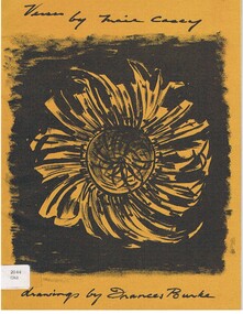
Book - ALEC H CHISHOLM COLLECTION: BOOK 'VERSES BY MAIE CASEY'
... Burke. Catalogue sticker '2044 CAS' on front cover. Maie Casey was the wife of Lord Casey, Australian politician and Governor General....Burke. Catalogue sticker '2044 CAS' on front cover. Maie Casey was the wife of Lord Casey, Australian politician and Governor General. ...Book. ALEC H CHISHOLM COLLECTION. A 19 page soft cover book of verse by Maie Casey with drawings by Frances Burke. Printed by McLaren & Co. Pty Ltd, Melbourne in 1963. (copy No. 213) Handwritten in ink on flyleaf 'Mr Alec Chisholm with best wishes from Maie Casey 8.11.63. Also the signature of Frances Burke. Catalogue sticker '2044 CAS' on front cover. Maie Casey was the wife of Lord Casey, Australian politician and Governor General.Maie Caseybooks, collections, poetry, alec h chisholm collection, poetry, maie casey, frances burke -
 Ringwood and District Historical Society
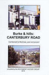
Book, Burke & Hills: Canterbury Road Camberwell to Montrose, by Heathmont History Group - 2014
... Governor, is a fascinating study in land use and history as suburban Melbourne has continually diversified and pushed outwards. Compiled by Heathmont History Group, Rita James, Les Prato, Betty Colbert, Jeff Leipold, Gerry Robinson (convenor). Soft cover book of 40 pages with spiral wire spine. Compilation of images and descriptive timeline of the geology, geography and European settlement history of Canterbury Road. Burke ...Soft cover book of 40 pages with spiral wire spine. Compilation of images and descriptive timeline of the geology, geography and European settlement history of Canterbury Road.Soon after beginning at Burke Road Camberwell, Canterbury Road moves into the gentle hills of Canterbury, then on to Surrey Hills, Box Hill and Forest Hill. Further along past these three "hills" come three "monts" - Vermont, Heathmont and at its other end, Montrose, by then in the foothills of the Dandenongs. Grand homes and churches at one end, major and minor shopping centres along the 25km, factories now where farms were, big box stores, fast food outlets, train stations, resrvoir, traffic, residential stretches, modern apartment blocks, parklands, child-minding centres, sporting ovals, a sewage farm, hotels, quarries, commercial developments, plant nurseries, a golf course, bridges, memorials, Asian food shops, telecommunication towers, bushland, creeks, crossroads, traffic lights, mansions, orchards, swamps ... Delaneys Road, renamed Canterbury Road after a 19th century Victorian Governor, is a fascinating study in land use and history as suburban Melbourne has continually diversified and pushed outwards. Compiled by Heathmont History Group, Rita James, Les Prato, Betty Colbert, Jeff Leipold, Gerry Robinson (convenor). -
 Glenelg Shire Council Cultural Collection
Decorative object - Commemorative Plate - Victoria's 150th Anniversary, Victoria's 150th Anniversary, c. 1984
... Governor David Collins, John Batman, Capt. Will Lonsdale, Sir Richard Burke, Charles Joseph La Trobe. ...Governor David Collins, John Batman, Capt. Will Lonsdale, Sir Richard Burke, Charles Joseph La Trobe. ...Victoria's 150th anniversary commemorative plate. White china, round, gold rim around autside, and inner depression. Centre has coloured representation of Exhibition Build in Carlton Gardens, Melbourne, Vic. Outer rim has sepia sketches of Matthew Flinders, Lt. Governor David Collins, John Batman, Capt. Will Lonsdale, Sir Richard Burke, Charles Joseph La Trobe. Also 'Victoria's 150th Anniversary' flanked by helmeted honeyeater and Leadbeater's possumBack: See also, Other Information 'Victoria's 150 years' Issue No. 457, Maker's stamp, Macquarie Heritage stampvictorias 150th anniversary, commemorative, souvenir -
 Ballarat Tramway Museum
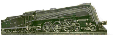
Drawing - Illustration/s, South Australian Railways, SAR locomotive card, 1936
... Reference -"Kings of the Iron Horse" by David Burke, page 164 -5 - gives details of the launch of the locomotive, 'Sir Winston Dugan', then Governor of South Australia. ...Reference -"Kings of the Iron Horse" by David Burke, page 164 -5 - gives details of the launch of the locomotive, 'Sir Winston Dugan', then Governor of South Australia. ...Photographic illustration of South Australian Railways Locomotive No. 620, the has been printed onto card and then cut out in the form of outline of the locomotive. Printed in green ink and then over printed in a silver ink to highlight the locomotive. On the rear of the illustration has been printed details of the locomotive (Light Pacific Engine), designed and built at SAR's Islington Workshops. Gives details of the locomotive, SAR's service. Notes that SAR has given 80 years of service. Printed by the Government Printer Adelaide. Reference -"Kings of the Iron Horse" by David Burke, page 164 -5 - gives details of the launch of the locomotive, 'Sir Winston Dugan', then Governor of South Australia. Photo of the launch and locomotive on opposite page 196. Would probably have been made for the launch of locomotive or soon after. Part of the centenary celebrations of the founding of South Australia. See "Kings of the Iron Horse" - A.E. Smith and F. J. Shea by David Burke.trams, tramways, sar, locomotives -
 Sunshine and District Historical Society Incorporated
Archive - City of Sunshine
... Typed Report General Information on the City of Sunshine 1987 to 1988|Newspaper Article 13 October 1993 The Age How rubish tips can be a big turn on|Envelope Town Clerk Sunshine City Council|Flyer City of Sunshine Community Day Festival 23 April 1994|Brochure City of Sunshine City of the Future Community Meeting 5 March 1994 Moonee Valley|Brochure City of Sunshine Multicultural City of Victoria Community Meeting 14 September 1991 Moonee Valley|Brochure City of Sunshine The Conferring of The Freedom of Entry to the City of Sunshine Upon The First Try City of Sunshine Regional Cadet Unit on 16 May 1987|Brochure City of Sunshine The Conferring of The Freedom of Entry to the City of Sunshine Upon No 5 Flight Air Training Corps Tottenham 18 November 1989|Photograph and photocopies of building with handwritten notes 444 $136.89|Logo of City of Sunshine Victoria|Brochure Your share in Sunshine City of Sunshine A Progressive Municipality|Brochure City of Sunshine The Conferring of the Freedom of the City of Sunshine upon 5th and 6th Battalion The Royal Victoria Regiment 12 February 1994|Hand drawings with handwritten notes 441 $32.09|Hand drawings with handwritten notes 256 $12.64|Hand drawings with handwritten notes 258 $17.233|Hand drawings with handwritten notes 250 $15.60|Hand drawings with handwritten notes 260 $19.72|Hand drawings with handwritten notes 255 $8.26|Hand drawings with handwritten notes 440 $6.19|Hand drawings with handwritten notes 387 $34.09|Hand drawings with handwritten notes 259 $12.49|Brochure City of Sunshine Development Update October 1988|Newsletter Grapewine City of Sunshine Staff Newsletter June 1992|Typed Letter City of Sunshine Community Bus Information Sheet 21 March 1979|Map Greening Sunshine Current Work in Progress 1992 to 1993|Newspaper Article A Place in the Sun Exotic plants along Railway lines|Flyer Sunshine City Council News Vol 1 No 1 August 1974 Inflation Whats happening to Councils Money|Newspaper Article Footscray Advertiser 17 February 1917 Braybrook Council|Flyer Sunshine City Council News Vol 1 No 1 April 1975 Leaping into Sunshine New World|Flyer Sunshine your city August 1961 Facts you should know Administration commended|Flyer Sunshines Gardens Parks and Streets 1991 to 1992|Invitation sent 28 June 1982 Government Reception to farewell Governor General of the Commonwealth of Australia on 8 July 1982 Commissioner AG and Mrs Gillen at National Gallery of Victoria|City of Sunshine Crest Motto is By Industry|Flyer Sunshine City Burke and Wills Camel Cup 24 April 1994 on Massey Ferguson Harvester site|Booklet Sunshine Yearbook 1972 Suburban Services Directories and Yearbooks|Enrolment form City of Sunshine Holiday Programme 7 May to 18 May 1984|Christmas Wishes Card from Chief Secretary Victoria t0 GM Prendergast Christmas 1927|Typed Letter 1 January 1984 A Personal Invitation from the Mayor|Newspaper Article The Advocate 9 September 1992 Public to have say Brooklyn tug of war|Newspaper Article Local Government Focus Special Feature November 1986 The City of Sunshine Multicultural City of Victoria Message from the Mayor|Brochure City of Sunshine Municipal Profile|Brochure City of Sunshine Accommodating the Future A Strategy for Housing Needs|Brochure Sunshine City Centre Development|Photocopy Mayors City of Sunshine|Brochure Local Solutions to a Global Problem our gift to future generations GEC ALSTHOM Energy Park Hulett St Albion|Brochure Melbournes West on the Move Melbournes Western Region Profile|Brochure Sunshine District Centre Market Square Interchange Public Transport|Certificate of Speical Civic Service for the Municipality of Sunshine|Brochure New Municipal Offices City of Sunshine Victoria|Newspaper Article Sunshine Community 1972 Can you imagine what $800 Million dollars looks like|Brochure Shire of Braybrook Office Welcome Home tendered to Maidstone Returned Services Personnel 2nd August 1946|Brochure City of Sunshine Live work and recreate in Sunshine|Sunshine City Council No 7 Council Report|Section of Minutes 24 March 199 Sunshine Logo competition won by Mr Stephen Jones of Laverton|Photocopy of Mayoral Pendant presented to City of Sunshine by Cr AG Pennel JP to commemorate its proclamatonas a city 16 May 1951|Flyer City of Sunshine Corporation Logo 24 March 1992 The logo was chosen from 94 other logos submitted as part of a community competiiton to find a new corporate logo. ...City of Sunshine Typed Report General Information on the City of Sunshine 1987 to 1988|Newspaper Article 13 October 1993 The Age How rubish tips can be a big turn on|Envelope Town Clerk Sunshine City Council|Flyer City of Sunshine Community Day Festival 23 April 1994|Brochure City of Sunshine City of the Future Community Meeting 5 March 1994 Moonee Valley|Brochure City of Sunshine Multicultural City of Victoria Community Meeting 14 September 1991 Moonee Valley|Brochure City of Sunshine The Conferring of The Freedom of Entry to the City of Sunshine Upon The First Try City of Sunshine Regional Cadet Unit on 16 May 1987|Brochure City of Sunshine The Conferring of The Freedom of Entry to the City of Sunshine Upon No 5 Flight Air Training Corps Tottenham 18 November 1989|Photograph and photocopies of building with handwritten notes 444 $136.89|Logo of City of Sunshine Victoria|Brochure Your share in Sunshine City of Sunshine A Progressive Municipality|Brochure City of Sunshine The Conferring of the Freedom of the City of Sunshine upon 5th and 6th Battalion The Royal Victoria Regiment 12 February 1994|Hand drawings with handwritten notes 441 $32.09|Hand drawings with handwritten notes 256 $12.64|Hand drawings with handwritten notes 258 $17.233|Hand drawings with handwritten notes 250 $15.60|Hand drawings with handwritten notes 260 $19.72|Hand drawings with handwritten notes 255 $8.26|Hand drawings with handwritten notes 440 $6.19|Hand drawings with handwritten notes 387 $34.09|Hand drawings with handwritten notes 259 $12.49|Brochure City of Sunshine Development Update October 1988|Newsletter Grapewine City of Sunshine Staff Newsletter June 1992|Typed Letter City of Sunshine Community Bus Information Sheet 21 March 1979|Map Greening Sunshine Current Work in Progress 1992 to 1993|Newspaper Article A Place in the Sun Exotic plants along Railway lines|Flyer Sunshine City Council News Vol 1 No 1 August 1974 Inflation Whats happening to Councils Money|Newspaper Article Footscray Advertiser 17 February 1917 Braybrook Council|Flyer Sunshine City Council News Vol 1 No 1 April 1975 Leaping into Sunshine New World|Flyer Sunshine your city August 1961 Facts you should know Administration commended|Flyer Sunshines Gardens Parks and Streets 1991 to 1992|Invitation sent 28 June 1982 Government Reception to farewell Governor General of the Commonwealth of Australia on 8 July 1982 Commissioner AG and Mrs Gillen at National Gallery of Victoria|City of Sunshine Crest Motto is By Industry|Flyer Sunshine City Burke and Wills Camel Cup 24 April 1994 on Massey Ferguson Harvester site|Booklet Sunshine Yearbook 1972 Suburban Services Directories and Yearbooks|Enrolment form City of Sunshine Holiday Programme 7 May to 18 May 1984|Christmas Wishes Card from Chief Secretary Victoria t0 GM Prendergast Christmas 1927|Typed Letter 1 January 1984 A Personal Invitation from the Mayor|Newspaper Article The Advocate 9 September 1992 Public to have say Brooklyn tug of war|Newspaper Article Local Government Focus Special Feature November 1986 The City of Sunshine Multicultural City of Victoria Message from the Mayor|Brochure City of Sunshine Municipal Profile|Brochure City of Sunshine Accommodating the Future A Strategy for Housing Needs|Brochure Sunshine City Centre Development|Photocopy Mayors City of Sunshine|Brochure Local Solutions to a Global Problem our gift to future generations GEC ALSTHOM Energy Park Hulett St Albion|Brochure Melbournes West on the Move Melbournes Western Region Profile|Brochure Sunshine District Centre Market Square Interchange Public Transport|Certificate of Speical Civic Service for the Municipality of Sunshine|Brochure New Municipal Offices City of Sunshine Victoria|Newspaper Article Sunshine Community 1972 Can you imagine what $800 Million dollars looks like|Brochure Shire of Braybrook Office Welcome Home tendered to Maidstone Returned Services Personnel 2nd August 1946|Brochure City of Sunshine Live work and recreate in Sunshine|Sunshine City Council No 7 Council Report|Section of Minutes 24 March 199 Sunshine Logo competition won by Mr Stephen Jones of Laverton|Photocopy of Mayoral Pendant presented to City of Sunshine by Cr AG Pennel JP to commemorate its proclamatonas a city 16 May 1951|Flyer City of Sunshine Corporation Logo 24 March 1992 The logo was chosen from 94 other logos submitted as part of a community competiiton to find a new corporate logo. ...Typed Report General Information on the City of Sunshine 1987 to 1988|Newspaper Article 13 October 1993 The Age How rubish tips can be a big turn on|Envelope Town Clerk Sunshine City Council|Flyer City of Sunshine Community Day Festival 23 April 1994|Brochure City of Sunshine City of the Future Community Meeting 5 March 1994 Moonee Valley|Brochure City of Sunshine Multicultural City of Victoria Community Meeting 14 September 1991 Moonee Valley|Brochure City of Sunshine The Conferring of The Freedom of Entry to the City of Sunshine Upon The First Try City of Sunshine Regional Cadet Unit on 16 May 1987|Brochure City of Sunshine The Conferring of The Freedom of Entry to the City of Sunshine Upon No 5 Flight Air Training Corps Tottenham 18 November 1989|Photograph and photocopies of building with handwritten notes 444 $136.89|Logo of City of Sunshine Victoria|Brochure Your share in Sunshine City of Sunshine A Progressive Municipality|Brochure City of Sunshine The Conferring of the Freedom of the City of Sunshine upon 5th and 6th Battalion The Royal Victoria Regiment 12 February 1994|Hand drawings with handwritten notes 441 $32.09|Hand drawings with handwritten notes 256 $12.64|Hand drawings with handwritten notes 258 $17.233|Hand drawings with handwritten notes 250 $15.60|Hand drawings with handwritten notes 260 $19.72|Hand drawings with handwritten notes 255 $8.26|Hand drawings with handwritten notes 440 $6.19|Hand drawings with handwritten notes 387 $34.09|Hand drawings with handwritten notes 259 $12.49|Brochure City of Sunshine Development Update October 1988|Newsletter Grapewine City of Sunshine Staff Newsletter June 1992|Typed Letter City of Sunshine Community Bus Information Sheet 21 March 1979|Map Greening Sunshine Current Work in Progress 1992 to 1993|Newspaper Article A Place in the Sun Exotic plants along Railway lines|Flyer Sunshine City Council News Vol 1 No 1 August 1974 Inflation Whats happening to Councils Money|Newspaper Article Footscray Advertiser 17 February 1917 Braybrook Council|Flyer Sunshine City Council News Vol 1 No 1 April 1975 Leaping into Sunshine New World|Flyer Sunshine your city August 1961 Facts you should know Administration commended|Flyer Sunshines Gardens Parks and Streets 1991 to 1992|Invitation sent 28 June 1982 Government Reception to farewell Governor General of the Commonwealth of Australia on 8 July 1982 Commissioner AG and Mrs Gillen at National Gallery of Victoria|City of Sunshine Crest Motto is By Industry|Flyer Sunshine City Burke and Wills Camel Cup 24 April 1994 on Massey Ferguson Harvester site|Booklet Sunshine Yearbook 1972 Suburban Services Directories and Yearbooks|Enrolment form City of Sunshine Holiday Programme 7 May to 18 May 1984|Christmas Wishes Card from Chief Secretary Victoria t0 GM Prendergast Christmas 1927|Typed Letter 1 January 1984 A Personal Invitation from the Mayor|Newspaper Article The Advocate 9 September 1992 Public to have say Brooklyn tug of war|Newspaper Article Local Government Focus Special Feature November 1986 The City of Sunshine Multicultural City of Victoria Message from the Mayor|Brochure City of Sunshine Municipal Profile|Brochure City of Sunshine Accommodating the Future A Strategy for Housing Needs|Brochure Sunshine City Centre Development|Photocopy Mayors City of Sunshine|Brochure Local Solutions to a Global Problem our gift to future generations GEC ALSTHOM Energy Park Hulett St Albion|Brochure Melbournes West on the Move Melbournes Western Region Profile|Brochure Sunshine District Centre Market Square Interchange Public Transport|Certificate of Speical Civic Service for the Municipality of Sunshine|Brochure New Municipal Offices City of Sunshine Victoria|Newspaper Article Sunshine Community 1972 Can you imagine what $800 Million dollars looks like|Brochure Shire of Braybrook Office Welcome Home tendered to Maidstone Returned Services Personnel 2nd August 1946|Brochure City of Sunshine Live work and recreate in Sunshine|Sunshine City Council No 7 Council Report|Section of Minutes 24 March 199 Sunshine Logo competition won by Mr Stephen Jones of Laverton|Photocopy of Mayoral Pendant presented to City of Sunshine by Cr AG Pennel JP to commemorate its proclamatonas a city 16 May 1951|Flyer City of Sunshine Corporation Logo 24 March 1992 The logo was chosen from 94 other logos submitted as part of a community competiiton to find a new corporate logo. Designer ws Mr Steve Jones of Laverton.|Sunshine District Centre Aerial Perspective Market Sqaure : Pollard Reserve : The Overpass and Railway Line sketchcity of sunshine -
 Kew Historical Society Inc
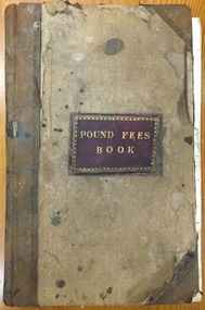
Administrative record (item), Borough of Kew, Pound Fees Book, 1874-1896
... While the first successful land sales in Boroondara occurred in Hawthorn in 1843, and Kew in 1845, these areas were to be without local pounds until April 1858, when the Governor of Victoria, in accordance with Act 18 Victoria No 30, was pleased to direct the establishment of a Pound at Glass’s Creek on that part of land bounded by the Kilby Road, Burke Road and High Street. ...Kew Historical Society Inc Kew Court House 188 High Street Kew melbourne While the first successful land sales in Boroondara occurred in Hawthorn in 1843, and Kew in 1845, these areas were to be without local pounds until April 1858, when the Governor of Victoria, in accordance with Act 18 Victoria No 30, was pleased to direct the establishment of a Pound at Glass’s Creek on that part of land bounded by the Kilby Road, Burke Road and High Street. ...While the first successful land sales in Boroondara occurred in Hawthorn in 1843, and Kew in 1845, these areas were to be without local pounds until April 1858, when the Governor of Victoria, in accordance with Act 18 Victoria No 30, was pleased to direct the establishment of a Pound at Glass’s Creek on that part of land bounded by the Kilby Road, Burke Road and High Street. While the Governor was required to proclaim the establishment of a pound, the appointment of a poundkeeper was the responsibility of the Justices of the Peace in the local Court of Petty Sessions. The Pound took its name from the most distinctive natural feature of the area, Glass’s Creek, named after the early pastoralist Thomas Glass.The register is of historic significance as an indicator of suburban life in the second half of the 19th Century. It shows how farming and city life on the urban fringe were intimately connected. It is also significant to the early history of Hawthorn and Kew, who both claimed the Pound following their separation from the Boroondara Roads Board in 1861."Kew Pound Book"glass creek pound (kew), animal pound, dog pound, kew pound, j. smith, john oakes, samuel b. cash, edward s. delaney, emma oswin, samuel cash