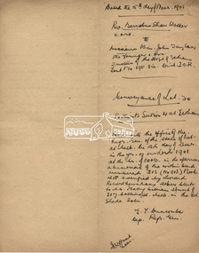
Showing 87 items matching " holloway street"
-
 Stawell Historical Society Inc
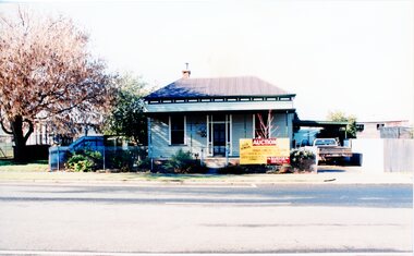
Photograph, House Removal. Victoria Street Rob Holloway, July 1996
... House Removal. Victoria Street Rob Holloway.... -4 Looking back towards the house on the truck -5 The house on the truck just before turning a corner Streetscape 6 colour photographs showing the parks and gardens superintendents house House Removal. Victoria Street Rob Holloway Photograph ...7103 - House with auction removal sign. -1 The view across the road to central park -2 View from the side showing seedling house and Stawell Bowling club -3 Showing the house on the truck looking towards the cab of the truck. -4 Looking back towards the house on the truck -5 The house on the truck just before turning a corner6 colour photographs showing the parks and gardens superintendents house streetscape -
 Glen Eira Historical Society
Document - Grange Road, 77, Glen Huntly
... ... Holloway Street...Barnard Ernest F Gorrie Gertrude Gorrie Hulbert Hopetoun Hobart John Bertram Coorigil Road Carnegie Holloway St Ormond Chemists Parish of Prahran Caulfield County of Bourke Building Agreement Brick Houses Builders Plans Architectural Drawings Grange Road Glen Huntly Holloway Street Ormond Emma Street Grange Road Neerim Road Gorrie H.H Gorrie Gertrude Gorrie Hulbert H Legal Documents Barnard Ernest Franklin E. ...This file contains 4 items about the purchase and construction of this property: 1/ The original contract of sale of land dated 25/09/1936 for Gertrude & Hulbert Gorrie situated on the corner of Grange and Neerim Road. 2/ The original typed building agreement dated 25/09/1936 between the contractor Ernest F Barnard and the purchasers Mr & Mrs Hulbert Gorrie. 3/ The original blueprint plan of a brick villa at the corner of Grange & Neerim Road for Mr & Mrs Hulbert Gorrie. Dated 25/09/1936. 4/ The original specification for the dwelling on the corner of Grange & Neerim Road, Glen Huntly for Mrs Gertrude Gorrie & Mr Hulbert Hopetoun Gorrie by builder Ernest F Barnard.barnard ernest f, gorrie gertrude, gorrie hulbert hopetoun, hobart john bertram, coorigil road, carnegie, holloway st, ormond, chemists, parish of prahran, caulfield county of bourke, building agreement, brick houses, builders, plans, architectural drawings, grange road, glen huntly, holloway street, ormond, emma street, grange road, neerim road, gorrie h.h, gorrie gertrude, gorrie hulbert h, legal documents, barnard ernest franklin, e. j. & h. amos, hintons nursery, real estate agents, murrumbeena, caulfield -
 City of Moorabbin Historical Society (Operating the Box Cottage Museum)
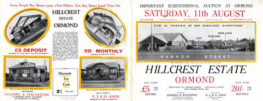
Flyer, 1928
... ...Holloway Street...Example of the progress of the Municipality of Moorabbin arker Street Holloway Street Wild Cherry Road Ormond Real Estate Hillcrest Estate, Ormond - Auction Saturday 11August 1928 Advertising flyer for auction of real estate sales - plan of building blocks for sale with pictures of local houses Flyer ...The train line from the city to Frankston was electrified which intensified the sale in the municipality of Moorabbin, particularly land which was in the vicinity of the railway stations.Example of the progress of the Municipality of MoorabbinAdvertising flyer for auction of real estate sales - plan of building blocks for sale with pictures of local housesHillcrest Estate, Ormond - Auction Saturday 11August 1928arker street, holloway street, wild cherry road, ormond, real estate -
 City of Moorabbin Historical Society (Operating the Box Cottage Museum)
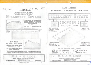
Flyer - Hillcrest Estate, Ormond, 1927
... ...Holloway Street...Example of the progress of the Municipality of Moorabbin Parker Street Holloway Street Wild Cherry Road Wallen Road Florence Street Wimmera Street Leila Road real estate Ormond auction Hillcrest Estate, Ormond - 26 Home sites for auction Saturday 26 February 1927. ...The train line from the city to Frankston was electrified in 1922 which intensified the sale in the municipality of Moorabbin, particularly land which was in the vicinity of the railway stations.Example of the progress of the Municipality of MoorabbinPhotocopy of advertising flyer for auction of real estate sales - plan of building blocks for saleHillcrest Estate, Ormond - 26 Home sites for auction Saturday 26 February 1927.parker street, holloway street, wild cherry road, wallen road, florence street, wimmera street, leila road, real estate, ormond, auction -
 City of Moorabbin Historical Society (Operating the Box Cottage Museum)
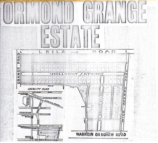
Flyer - Ormond Grange Estate, Ormond, 1913
... Holloway Street...Example of the progress of the Municipality of Moorabbin Holloway Street Wild Cherry Road Parker Street Ormond Land sales real estate Ormond Grange Estate Photo copy of advertising flyer for auction of real estate sales - plan of building blocks for sale Flyer Ormond Grange Estate, Ormond ...At the end of World War One, there was a renewed interest in residential land and a number of estates opened up in the Municipality of Moorabbin.Example of the progress of the Municipality of MoorabbinPhoto copy of advertising flyer for auction of real estate sales - plan of building blocks for saleOrmond Grange Estateholloway street, wild cherry road, parker street, ormond, land sales, real estate -
 Greensborough Historical Society
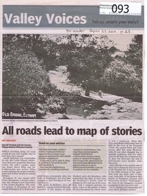
Newspaper - Newspaper clipping, All roads lead to map of stories, 27/04/2011
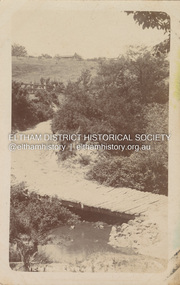
... holloway...jack shallard...susanna maria bible...bradbury...henry brougham...handfield...fay harcourt...violet bank...kangaroo ground...bells hillroad...shalbury avenue...beard street...Family history of Josiah Holloway, origins of street names in the subdivision of Eltham ...Greensborough Historical Society 34A Glenauburn Road Lower Plenty Lower Plenty melbourne Family history of Josiah Holloway, origins of street names in the subdivision of Eltham History of Eltham and origins of street names connected with pioneers of the area. josiah holloway jack shallard susanna maria bible bradbury henry brougham handfield fay harcourt violet bank kangaroo ground bells hillroad shalbury avenue beard street brougham street main road eltham DV Leader April27 2011, p23 Newsprint, gray scale. ...Family history of Josiah Holloway, origins of street names in the subdivision of Eltham History of Eltham and origins of street names connected with pioneers of the area.Newsprint, gray scale. Photograph of Keylock's Bridge on Diamond Creek at ElthamDV Leader April27 2011, p23josiah holloway, jack shallard, susanna maria bible, bradbury, henry brougham, handfield, fay harcourt, violet bank, kangaroo ground, bells hillroad, shalbury avenue, beard street, brougham street, main road, eltham -
 Stawell Historical Society Inc
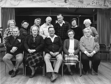
Photograph, Senior Citizens Club Office Bearers in the Clubrooms 1991-1992
... Back row Daphne Beckwith, Nellie Blake, Myrtle Pyke, Cec Dredge, Stan Raeburn, Florence Unthank, Ella Holloway. Front Row John Street, Nat Raeburn, Jim Bigmore, Nellie Howen Bonnie Dean. ...Back row Daphne Beckwith, Nellie Blake, Myrtle Pyke, Cec Dredge, Stan Raeburn, Florence Unthank, Ella Holloway. Front Row John Street, Nat Raeburn, Jim Bigmore, Nellie Howen Bonnie Dean. stawell Black & white photograph of group of people inside a hall. ...Group inside Senior Citizens Clubrooms. Back row Daphne Beckwith, Nellie Blake, Myrtle Pyke, Cec Dredge, Stan Raeburn, Florence Unthank, Ella Holloway. Front Row John Street, Nat Raeburn, Jim Bigmore, Nellie Howen Bonnie Dean. Black & white photograph of group of people inside a hall. One row seated the other standing behind the seated row.stawell -
 Eltham District Historical Society Inc
Photograph, Wendy Wilson, Our Lady Help of Christians Primary School, 1-13 Henry St, Eltham, c.1980
... A new church was erected on the opposite (southern) side of Henry Street in 1976, partially on the original Lot 20 Henry Street of Holloway's Little Eltham North estate. Lot 20 Henry Street was the site of the former Wesleyan Church chapel in the 1850s which also used by David and Catherine Clark to establish their first school in 1855 prior to the erection of the Dalton Street school in 1856. ...A new church was erected on the opposite (southern) side of Henry Street in 1976, partially on the original Lot 20 Henry Street of Holloway's Little Eltham North estate. Lot 20 Henry Street was the site of the former Wesleyan Church chapel in the 1850s which also used by David and Catherine Clark to establish their first school in 1855 prior to the erection of the Dalton Street school in 1856. ...Our Lady Help of Christians Primary School - The hall on the left side was the original Our Lady Help of Christians Church which was built c.1962 on the site of the former weatherboard St Mary's Church which was destroyed by fire in 1961. A new church was erected on the opposite (southern) side of Henry Street in 1976, partially on the original Lot 20 Henry Street of Holloway's Little Eltham North estate. Lot 20 Henry Street was the site of the former Wesleyan Church chapel in the 1850s which also used by David and Catherine Clark to establish their first school in 1855 prior to the erection of the Dalton Street school in 1856. The chapel was replaced by a new building, the Eltham Rechabite Hall (1893-1921) which then became the Eltham Public Hall (1922-1940). The Eltham Fire Station was also situated adjacent from 1931 to 1935. our lady help of christians primary school, henry street, eltham -
 Eltham District Historical Society Inc
Facsimile Newspaper, The Times, Late The Port Phillip Gazette, 12 April 1851, p1
... HOLLOWAY, “Red Boot,” Swanston-street, Opposite the Shepherd’s Arms N.B....M. HOLLOWAY, “Red Boot,” Swanston-street, Opposite the Shepherd’s Arms N.B. ...Copy of front page of an early Port Phillip newspaper. It includes several articles including the announcement of a new township called Little Eltham. The artcile is transcribed as follows: NEW TOWNSHIP OF LITTLE ELTHAM Adjoining the Government Township of Eltham on the Yarra River. Half-acre Allotments for Sale in the above Township, at 35s. each; Title—A Grant from the Crown to the Vendor. THE advertiser feels persuaded that to recommend the above property he need only state the three following undeniable facts: First.—The Diamond Creek, which yields a never failing supply of the purest water, runs through the whole length of the township. Second.—The boundary of the Government township reserve was fixed years back, when Melbourne itself was not expected to rise beyond a mere village and when the valuable building ground at Collingwood was sold in allotments containing about twenty-seven acre each. Third.—Immediately beyond the Government township the bank of the Yarra is so steep that water could with difficulty be obtained from the river; making it certain that the town will extend itself in the direction of the creek. The distance from Melbourne is about eleven miles in a straight line, and between 13 and 14 miles by road. Attention is particularly directed to the following, being the second article in the condition of sale—: That, to secure to the purchaser uninterrupted possession without the expense of a deed, an attested copy on parchment of the Crown’s Grant with the Vendors Receipt for the purchase money on the same sheet, will be given to each purchaser without charge. A plan is now on view, and the lots can be chosen at once. Application to be made to J. M. HOLLOWAY, “Red Boot,” Swanston-street, Opposite the Shepherd’s Arms N.B.—A plan of the property will be given to each purchaser.The announcement of J.M. Holloway's Little Eltham township in April 1851 is a significant event in the foundation of European settlement for the suburb of Eltham and its wider community today.Laminated front page and p2 (facsimile?)little eltham, newspaper, j m holloway, 1851, port phillip -
 Warrnambool and District Historical Society Inc.
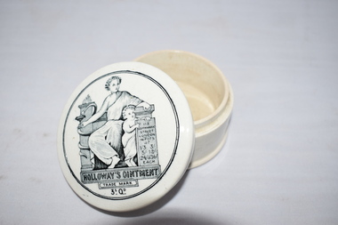
China, Dish Holloway's Ointment, 1920s
... ‘113 Southwark Street London’ ‘in Pots at 1/3, 3/-, 5/-, 12/-, 24/- & 36/- each’ ‘Holloway’s Ointment Trade Mark 3s 0d.’ ...Holloway’s Ointments Patent Medicines ‘113 Southwark Street London’ ‘in Pots at 1/3, 3/-, 5/-, 12/-, 24/- & 36/- each’ ‘Holloway’s Ointment Trade Mark 3s 0d.’ ...This pot contained ointment made by Thomas Holloway. The ointment was invented and produced by the Englishman Thomas Holloway from 1837 on. This particular pot was produced about the 1920s. The ointment was popular for those suffering from variety of ailments including gout, rheumatism, ulcers and bruises. The sales of Thomas Holloway’s patent medicines made him a wealthy man and amongst his endowments is the Holloway College in Surrey, England, now part of London University. This ointment pot has no known local provenance but is kept as an interesting example of patent medicines of the past. It will be useful for display. This is a white china pot with a lid fitting into a grooved top. The lid has a black and white image of the trade mark of the ointment firm – said to be the figure of the Muse, Hygeia and her brother Telesphorus. The child is holding a banner with the address of the Holloway business and the prices of the ointment jars. There is some slight chipping around the rim of the upper part of the pot. ‘113 Southwark Street London’ ‘in Pots at 1/3, 3/-, 5/-, 12/-, 24/- & 36/- each’ ‘Holloway’s Ointment Trade Mark 3s 0d.’ holloway’s ointments, patent medicines -
 Warrnambool and District Historical Society Inc.
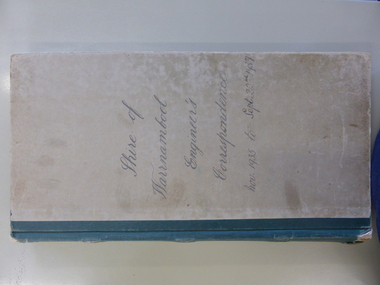
Legal record - Ledger, Shire of Warrnambool Engineer's Correspondence, Circa 1935
... Warrnambool and District Historical Society Inc. 2 Gilles Street (south of Merri St) Warrnambool great-ocean-road This ledger contains outward correspondence from the Shire of Warrnambool, Engineer from the period November 1935 to September 1937. It covers matters such as bridges, roads noxious weeds, drainage. It contains areas such as Wangoom Nirranda, Childers Cove, Hopkins Falls, Panmure and local names such as Jenkins, Holloway ...This ledger contains outward correspondence from the Shire of Warrnambool, Engineer from the period November 1935 to September 1937. It covers matters such as bridges, roads noxious weeds, drainage. It contains areas such as Wangoom Nirranda, Childers Cove, Hopkins Falls, Panmure and local names such as Jenkins, Holloway, Delaney, Davidson, Digby, Bennett, Kruger, McDowall. This collection of letters provides a very good overview of issues and work covered in the period 1935-1937.Grey card cover with dark green binding. Alphabetical index at the front . Following pages are light pink paper and numbered 1-500, two to a page. Label inside front cover Arnall & Jackson, printers lithographers, bookbinders, publishers, Manufacturing Stationers, 428 Collins St Melbourne. Repeat Order No B 87970 ledger engineer's correspondence, 1935 -1937, shire of warrnambool, warrnambool -
 Eltham District Historical Society Inc
Photograph, Fay Bridge, EDHS Heritage Walk: Shillinglaw Farm, Eltham, 2 September 2023
... Street then return via the Diamond Creek trail behind Andrew Park. The actual farm boundary went past the creek and further up the hill. The original farm comprised lot 90 of Holloway’s...Street then return via the Diamond Creek trail behind Andrew Park. The actual farm boundary went past the creek and further up the hill. The original farm comprised lot 90 of Holloway’s ...On Saturday September 2, 2023, Russell Yeoman led a group of 22 society members and interested others on a walk following trhe bounadries of the original Shillingalw farm. Commencing at the corner of Panther Place and Library Place, we proceeded up to Shillinglaw Cafe then the Shillinglaw trees at the former Eltham Shire Office site then along Main Road to the fire station then throughh St Laurence Lane and uinder the railway line , along Diamond Street then return via the Diamond Creek trail behind Andrew Park. The actual farm boundary went past the creek and further up the hill. The original farm comprised lot 90 of Holloway’s 1851 subdivision of Little Eltham. Its area was 30 acres lying east of the Diamond Creek and north of Henry Street. A number of stops were made to look at maps and early photos illustrating the gradual reduction of the farm area and the early history of the railway and other community uses, that occupied parts of the site.fay bridge collection, 2023-09-02, activities, eltham, eltham district historical society, heritage excursion, shillinglaw farm -
 Eltham District Historical Society Inc
Photograph, Liz Pidgeon, EDHS Heritage Walk: Shillinglaw Farm, Eltham, 2 September 2023
... Street then return via the Diamond Creek trail behind Andrew Park. The actual farm boundary went past the creek and further up the hill. The original farm comprised lot 90 of Holloway’s...Street then return via the Diamond Creek trail behind Andrew Park. The actual farm boundary went past the creek and further up the hill. The original farm comprised lot 90 of Holloway’s ...On Saturday September 2, 2023, Russell Yeoman led a group of 22 society members and interested others on a walk following trhe bounadries of the original Shillingalw farm. Commencing at the corner of Panther Place and Library Place, we proceeded up to Shillinglaw Cafe then the Shillinglaw trees at the former Eltham Shire Office site then along Main Road to the fire station then throughh St Laurence Lane and uinder the railway line , along Diamond Street then return via the Diamond Creek trail behind Andrew Park. The actual farm boundary went past the creek and further up the hill. The original farm comprised lot 90 of Holloway’s 1851 subdivision of Little Eltham. Its area was 30 acres lying east of the Diamond Creek and north of Henry Street. A number of stops were made to look at maps and early photos illustrating the gradual reduction of the farm area and the early history of the railway and other community uses, that occupied parts of the site.2023-09-02, activities, eltham, eltham district historical society, heritage excursion, shillinglaw farm, 895 main road, amplifon, andrew park, andrew pocket park, arthur street, bar de tapas, barber shop, barry plant estate agent, blockbuster, bus depot, car park, carparks, central park, cleaver & co hair, commonwealth bank, crust pizza, divine bridal, dr ash constance, dudley street, eltham book shop, eltham convenience store, eltham fire station, eltham library, eltham newsagency, eltham optical, eltham railway station, eltham shops, fay bridge, fire bell, flagpole, flight centre, grill'd, information sign, iso chook, jellis craig estate agent, judge book village, kebab nation, kx pilates, la zanyas, liquorland, little drop of poison, lorraine jones & associates solicitors, luck street, machan indian restaurant, main road, mecho en mexico, missing gorilla, morrison kleeman real estate, pavilion menswear, platform 3095, playtherapy melbourne, pryor street, ray white real estate, restaurants, sage bulk whole foods, shillinglaw trees, sign, snap fitness, southern cross medical imaging, specsavers, st laurence lane, st vincents care service, thompson's pharmacy, todaro, united service station, vyve body & skin, welcome to eltham town, westpac bank, yang's kitchen, youth road -
 Eltham District Historical Society Inc
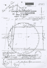
Document - Photocopy, Survey Field Notes of Part of Crown Portion 13, Section 4 at Eltham, Part of Lot 19 Subdivision of 13 Section IV (Holloways), Parish of Nillumbik, County of Evelyn, 5 May 1906
... Mackensie Tyers, Licensed Surveyor, 5 May 1906 Map Neil Webster Collection Survey Plan Surveyor Field Notes 1906 Application 33777 Application 35953 henry street Main Road Eltham Maria Street Rechabite Hall* A3 printouts, 2 pages Survey Field Notes of Part of Crown Portion 13, Section 4 at Eltham, Part of Lot 19 Subdivision of 13 Section IV (Holloways), Parish of Nillumbik, County of Evelyn Document Photocopy ...Portion of land bounded by: Main Road, Henry Street Application 35953 A. Mackensie Tyers, Licensed Surveyor, 5 May 1906map, neil webster collection, survey plan, surveyor field notes, 1906, application 33777, application 35953, henry street, main road eltham, maria street, rechabite hall* -
 Eltham District Historical Society Inc
Photograph - Digital Photograph, Alan King, Alistair Knox Park, Eltham, 2008
... Holloway. Other families who owned properties in that area, included Rees, Clark, Waterfall, Graham, Hill and Morant. In 1901 the railway was built through the area. Jock Read, an Eltham resident since around 1920, remembers several farms in the 1920s and ’30s that occupied the site of today’s park. A poultry farm, which extended from present day Panther Place, was owned by the Gahan family. Next to that farm was another for grazing cattle owned by Jack Carrucan. Beside this was land owned by John Lyon. A doctor lived beside this, and at the north-west corner of Bridge Street...Holloway. Other families who owned properties in that area, included Rees, Clark, Waterfall, Graham, Hill and Morant. In 1901 the railway was built through the area. Jock Read, an Eltham resident since around 1920, remembers several farms in the 1920s and ’30s that occupied the site of today’s park. A poultry farm, which extended from present day Panther Place, was owned by the Gahan family. Next to that farm was another for grazing cattle owned by Jack Carrucan. Beside this was land owned by John Lyon. A doctor lived beside this, and at the north-west corner of Bridge Street ...Alistair Knox Park, an oasis of peace and beauty. Covered under National Trust of Australia (Victoria) Landscape Significance and Heritage Overlay, Nillumbik Planning Scheme. Published: Nillumbik Now and Then / Marguerite Marshall 2008; photographs Alan King with Marguerite Marshall.; p173 It is hard to imagine that the Alistair Knox Park, an oasis of peace and beauty beside busy Main Road, Eltham, was once the township’s rubbish dump. It was only in the 1970s that the tip was transformed into this beautiful six hectare space, which later earned it a National Trust Landscape classification. Before its life as a dump, the area was used for small farms. Thanks largely to the foresight and efforts of local environmental builder Alistair Knox, the park was designed sympathetically with the character of the wider Eltham landscape. Then, appropriately, the park was named after Knox, who was an Eltham Shire Councillor from 1971 to 1975 and Shire President in 1975. The park designers were four major forces in the urban bush landscape garden –Knox, landscape designer Gordon Ford, artist Peter Glass and landscaper Ivan Stranger. The National Trust citation for the park, originally called Eltham Town Park, includes the Eltham railway trestle bridge and the Shillinglaw Cottage. The citation states ‘the semi-natural setting of the parkland provides a landscape which is evocative of the history of the area’. Manna Gums (Eucalyptus viminalis) and Candlebarks (Eucalyptus rubida) are significant features. Most of the park’s construction was directed by Bob Grant, Superintendent of the Parks and Gardens Department for the Eltham Shire Council. First plantings occurred in Arbour Week in 1973, then the lake and botanic area were completed in 1975, with Federal Government funding, and the toilet block in 1978. Bounded by the Eltham railway line, Panther Place, Main Road, Bridge and Susan Streets, the park is in a valley about a kilometre wide overlooked by steep hills at the east and west. The Diamond Creek flows through it and the picturesque historic timber trestle railway bridge edges the north. Informal plantings of Australian indigenous and native species in open and undulating grassed settings blend with the natural landscape of the Diamond Creek to the west. The bush-style plants, particularly around the creek, balance with open lawns, paths and a cascade flowing from a small lake to another below. A footbridge over the creek leads to the park’s west. The park includes an adventure playground and barbecue areas. The park stands on part of the land bought from the Crown in 1851 by Josiah Holloway, who subdivided it into allotments and which he called Little Eltham. Most of the land was subdivided into residential lots, but the creek valley, on which the park stands, was subdivided into farm-size lots, used mainly for orchards and grazing. One of the earliest owners was John Hicks Petty, who in 1874 bought a plot from Holloway. Other families who owned properties in that area, included Rees, Clark, Waterfall, Graham, Hill and Morant. In 1901 the railway was built through the area. Jock Read, an Eltham resident since around 1920, remembers several farms in the 1920s and ’30s that occupied the site of today’s park. A poultry farm, which extended from present day Panther Place, was owned by the Gahan family. Next to that farm was another for grazing cattle owned by Jack Carrucan. Beside this was land owned by John Lyon. A doctor lived beside this, and at the north-west corner of Bridge Street and Main Road stood a memorial to the soldiers who died in World War One, which was later moved to the RSL site. Mr Read also remembers other farms and orchards west of the creek In the early 1960s the Eltham Council began buying these farms and in the late 1960s turned the areas east of the Diamond Creek into a garbage tip. When this was filled above the creek’s flood plain, the tip was moved to the west of the creek.This collection of almost 130 photos about places and people within the Shire of Nillumbik, an urban and rural municipality in Melbourne's north, contributes to an understanding of the history of the Shire. Published in 2008 immediately prior to the Black Saturday bushfires of February 7, 2009, it documents sites that were impacted, and in some cases destroyed by the fires. It includes photographs taken especially for the publication, creating a unique time capsule representing the Shire in the early 21st century. It remains the most recent comprehenesive publication devoted to the Shire's history connecting local residents to the past. nillumbik now and then (marshall-king) collection, alistair knox park, eltham -
 Eltham District Historical Society Inc
Photograph - Colour Print, 'Kilbeggin', 7-9 John Street, Eltham, 22 July 1993
... Built about 1878 for carpenter Richard Bettison, John Street is part of the original Holloway subdivison in the area known as Little Eltham....Built about 1878 for carpenter Richard Bettison, John Street is part of the original Holloway subdivison in the area known as Little Eltham. kilbeggin eltham John Street Colour photo print 10 x 15 cm (x2) 'Kilbeggin', 7-9 John Street, Eltham Photograph Colour Print ..."Kilbeggin Cottage",a weatherboard house over two blocks at 7 - 9 John Street, Eltham. Built about 1878 for carpenter Richard Bettison, John Street is part of the original Holloway subdivison in the area known as Little Eltham.Colour photo print 10 x 15 cm (x2)kilbeggin, eltham, john street -
Glen Eira Historical Society
Letter - Rosstown Railway
... Street... Kooyong Road... Melbourne and Brighton Railway... Hawthorn Road... Bambra Road... Caulfield and Frankston Railway... Booran Road... Grange Road... Koornang Road... Murrumbeena Road... North Road... North Road Railway Station... East Brighton Railway Station... South Road... Railway Routes... Railway Lines... Railways... Land Transport... Murphy J.... Caulfield... Hamilton T.F.... Dane P.... Holloway...Garden Vale Elsternwick Elsternwick Railway Station Rosstown Rosstown Railway Thomas Street Bay Street Kooyong Road Melbourne and Brighton Railway Hawthorn Road Bambra Road Caulfield and Frankston Railway Booran Road Grange Road Koornang Road Murrumbeena Road North Road North Road Railway Station East Brighton Railway Station South Road Railway Routes Railway Lines Railways Land Transport Murphy J. Caulfield Hamilton T.F. Dane P. Holloway ...This file contains four items: 1/A black and white photocopy of a letter dated either 07/08/1889 or 09/08/1889, from Robert Lundon to an unidentified recipient discussing an agreement reached between the author – on behalf of the recipient – and Soon Hang Hi in regard, in regards to the allotment known as Webber’s. The agreement is outlined in the letter in what appears to be Chinese characters, and includes the marks of Robert Lundon and Soon Hang Hi. File note from Joy Wu states that the calligraphy is not Mandarin or traditional Chinese. 2/Three sheets of hand-written working notes with information taken from the Victorian Government Gazette on THE ROSSTOWN AND MURRUMBEENA LAND COMPANY LIMITED, THE ROSSTOWN JUNCTION RAILWAY AND PROSPERITY COMPANY LIOMITED, and THE ROSSTOWN JUNCTION, ELSTERNWICK, AND OAKLEIGH RAILWAY COMPANY LIMITED, covering dates between 1887 and 1894. The notes concern meetings and creditors claims relevant to the companies, with reference numbers for the information source. Date and author of the notes are not recorded. 3/A black and white photocopy of the a partial map of the Rosstown Railway and surrounding area, undated. The map includes the names of landholders in the areas of Brighton, Garden Vale and Elsternwick, as well as other railway lines present in the region. 4/A fold-out map and guide of the Rosstown Rail Trail, including a brief general history of Caulfield as well as a more extensive biography of William Murray Ross and the Rosstown Railway. The map marks and describes significant sites along the trail, including photographs of some of these sites, provided by DF Jowett.documents, correspondence, webber’s, lundon robert, chinese characters, ethnic communities, signatures, text, settlements, taxes, fraser john grieves, lovell r.h., price davies, meetings, communication activities, soon hang hi, commercial events and activities, the rosstown and murrumbeena land company limited, victorian government gazette, bulmer richard, parry john, osment henry, shareholders, creditors claims, the rosstown junction railway and property company limited, finch and best, lawyers, the rosstown junction elsternwick and oakleigh railway company limited, cameron w.c., phillips p.d., garden vale, elsternwick, elsternwick railway station, rosstown, rosstown railway, thomas street, bay street, kooyong road, melbourne and brighton railway, hawthorn road, bambra road, caulfield and frankston railway, booran road, grange road, koornang road, murrumbeena road, north road, north road railway station, east brighton railway station, south road, railway routes, railway lines, railways, land transport, murphy j., caulfield, hamilton t.f., dane p., holloway, webb, ailee john, payne t.b., brodie chas, dane john, o’neil h., mccombie john, mcmillane a., smyth c.d., cooper, ebden, landholders, jeffrey j.d., gill j., balcombe a.e., cooper h., mcnab j., white j., sutherland j., greeves a.f.a., newton m.c., chamley f.b., fowler j., inglis p., grant t., stooke j., swanson g., cochrane c., adams e.b., mccombie thas, keyes robert, brighton cemetery, burials grounds and graveyards, war-ein road, were j.b., holland j., mcmahon c., winter t.l.m., dendy henry, mitchell w., jackson s., were j.e., wickham francis dawe, bryant jane, east brighton railway station, railway stations, maps, allotments, land titles, roads and streets, rosstown rail trail, city of glen eira, tourism, trains, tourism information bureaus, tours, pamphlets, elsternwick railway park, oakleigh junction, princes park, ee gunn reserve, packer park, sites, jowett d.f., weickhardt i.g., return to rosstown: railways land sales and sugar beet ventures in caulfield, land sales, walking trails, ross william murray, transport objects, locomotion, walking, cycling, driving, sports, country mansions, people, caulfield john, builders, construction and demolition workers, occupations, careers, professionals, topography, geology, landforms, horticulture, market gardens, primary industry workers, city of caulfield, mood kee, pennington harold, annual general meetings, caulfield town hall, glen eira city council, carnegie, carnegie station, rosstown station, people by circumstance, migrants, sugar beet, sugar beet mill, sugar beet industry, mills, factories, sea beach lines, bent thomas, parliamentary representatives, neville street, miller street, lemann’s swamp reserve, koornang park, cane sugar industry, breweries, rabbit processing plants, health establishments, hospitals, food production establishments, abattoirs, thieves, social problems, vagrants, theft, squatting, financial economics, debt, finance industry, insurance companies, company managers, bentleigh, ross leila, the grange, leila road, wild cherry road, financial trouble, mortgages, gisborne street, archibald street, riddell parade, victoria railways, glen huntly road, clarence street, college street, gladstone parade, parrell street, aileen avenue, seaview street, land subdivisions, dover street, sussex street, landfill, marara road, booran road, woodville avenue, dorothy avenue, ormond park, royal avenue, ormond railway station, oakleigh road, melten avenue, miller street, munro avenue, lord reserve, neerim road, toolambool road, the rosstown hotel, rosanna street, murrumbeena crescent, commercial establishments, the national bank, rosstown road, kangaroo road, poath road, freda street, hughesdale kindergarten, oakleigh council, hughesdale community centre, civic establishments, galbally reserve, plaques, warrigal road, out and about brochures, orion estate -
 Eltham District Historical Society Inc
Photograph - Digital Photograph, Alan King, Eltham Living and Learning Centre, 26 January 2008
... He bought the three and a half acre (1.4ha) allotment fronting Maria Street (now Main Road) and stretching down to the Diamond Creek. The allotment formed part of a 316 acre (127.8ha) subdivision, owned by Josiah Holloway, called Little Eltham, north of the original Eltham Reserve.1 The allotment then passed through the hands of several speculators before it was sold to Pearson for £100 in 1857. ...He bought the three and a half acre (1.4ha) allotment fronting Maria Street (now Main Road) and stretching down to the Diamond Creek. The allotment formed part of a 316 acre (127.8ha) subdivision, owned by Josiah Holloway, called Little Eltham, north of the original Eltham Reserve.1 The allotment then passed through the hands of several speculators before it was sold to Pearson for £100 in 1857. ...In 1857, tanner John Pearson purchased three and a half acres of land in Little Eltham, at the western end of Pitt Street, with a 70-foot frontage to Maria Street (Main Road) and stretching down to the Diamond Creek for £100. He contracted Benjamin Oliver Wallis to build house for him. Wallis, a mason by trade who originated from the Cornish village of Newlyn, migrated to Melbourne in 1853 and was shortly engaged by Richard Warren to build the Eltham Hotel, which opened in 1854. When Warren fell into financial difficulty in 1858, Wallis purchased the hotel. That same year, Pearson constructed a tannery below the house with access to the water in the Diamond Creek. When Pearson became bankrupt in 1867, Wallis similarly acquired the house from Pearson’s creditors in 1868 and lived there until his death in 1896. For some of this time the house was in the name of Wallis’s son Richard but following his death in 1888, ownership reverted to his father. It was purchased by retired teacher Richard Gilsenen in 1899. Gilsenen was made acting head teacher at the Eltham State School in 1906 following the sudden death of head teacher John Brown. In the 1950s the house was bought by retired engineer Dr Alfred Fitzpatrick and his wife Claire who made various modifications to house goats and poultry as well as structural modifications to the house. In the early 1970s, Eltham Shire Councillors Frank Maas and Don Maling proposed an extended communities’ activities program be set up and the Commonwealth Grants Commission was approached for financial assistance. In 1974 a $50,000 Commonwealth Grant was received by the Shire Council to acquire the Fitzpatrick property as part of the planning to establish an extended communities’ activities program. The Fitzpatricks moved next door and Claire taught at the new Living and Learning Centre, which began in 1975, one of the first community education centres in Victoria. Covered under Heritage Overlay, Nillumbik Planning Scheme. Published: Nillumbik Now and Then / Marguerite Marshall 2008; photographs Alan King with Marguerite Marshall.; p59 It’s a centre for sharing knowledge and friendship and it stands on the former hub of Eltham’s original township near Pitt Street. The Eltham Living and Learning Centre, with around 2000 participants a year, began in 1975 as one of the first Community Education Centres in Victoria. Classes ranging from macramé to wine making to environmental living have enriched the lives of thousands of people through the generosity of tutors sharing their skills free of charge. The centre’s heart is the brick cottage, built in 1858 by tanner John Pearson. He bought the three and a half acre (1.4ha) allotment fronting Maria Street (now Main Road) and stretching down to the Diamond Creek. The allotment formed part of a 316 acre (127.8ha) subdivision, owned by Josiah Holloway, called Little Eltham, north of the original Eltham Reserve.1 The allotment then passed through the hands of several speculators before it was sold to Pearson for £100 in 1857. Mr Pearson’s children attended the Eltham Primary School from 1864 to 1867. But creditors took possession of the property when his tannery folded in 1867. It was then sold to publican Benjamin Wallis, who owned the Eltham Hotel at the corner of Pitt Street and Main Road. In 1899 the property was bought by Richard Gilsenan, who became acting head teacher of the Eltham Primary State School in 1906. In the 1950s, retired engineer Dr Alfred Fitzpatrick and his wife Claire bought the property, and made structural changes. Claire, a journalist and community campaigner, modified and built pens for goats and poultry, a stable, a garage and planted fruit trees and a vegetable garden. In the early 1970s a young woman called Carina Hack approached Gwen Wesson at the Diamond Valley Learning Centre (Victoria’s first Community Education Centre) about starting a community centre. Following Wesson’s suggestion, Hack spoke to Shire President Alistair Knox ‘one bleak rainy afternoon, sipping hot drinks and discussing life’.2 Eltham Shire Councillors Frank Maas and Don Maling proposed a community activities program and the council received a $50,000 Commonwealth Government Grant for this venture.3 The Fitzpatricks sold their property to the council and moved next door and Claire taught at the new centre, which Hack named. Eltham obviously wanted such a centre as Hack recalls. ‘During the next two months we had about 50 volunteers working day, night and weekends, scrubbing down, plastering and painting walls, replacing floors, repairing fences, recycling furniture, sewing curtains and cushions, donating furniture, toys, equipment, clean-ing and gardening…’4 The first enrolment day saw a queue stretching up the driveway nearly to the gate and the first sessions attracted 270 people a week. Soon the outbuildings were converted into pottery studios and a large workshop. From 1979 the Eltham Art and Craft Market was held in the centre’s grounds and the Friends of the Centre ran it from 1980. A former program coordinator, Margaret Johnson, remembers enrolment day in the late 1970s and 1980s, when hundreds of people would queue – and some even camped overnight! Overnighters were greeted in the morning with fresh tea and toast. Another tradition was The Enrolment Day Cake with Recipe, given to volunteers. ‘One happy Enrolment Day fell on February 14 and let’s just say that St Valentine found some willing participants, paying $2 for a kiss.’5 Meanwhile the participants’ children could play at the Council Eltham Lower Park house in Hohnes Road, later in Susan Street. But the centre has had difficulties too. In 1990 a fire destroyed the stable and the police suspected arson. However the pavilion was built in its place.This collection of almost 130 photos about places and people within the Shire of Nillumbik, an urban and rural municipality in Melbourne's north, contributes to an understanding of the history of the Shire. Published in 2008 immediately prior to the Black Saturday bushfires of February 7, 2009, it documents sites that were impacted, and in some cases destroyed by the fires. It includes photographs taken especially for the publication, creating a unique time capsule representing the Shire in the early 21st century. It remains the most recent comprehenesive publication devoted to the Shire's history connecting local residents to the past. nillumbik now and then (marshall-king) collection, benjamin oliver wallis, claire fitzpatrick, don maling, dr alfred fitzpatrick, eltham living and learning centre, frank maas, john pearson, richard gilsenen, tannery -
 Eltham District Historical Society Inc
Photograph - Digital Photograph, Alan King, Shillinglaw Cottage, 6 January 2008
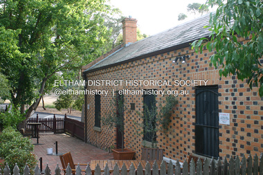
... The site was the largest in what Holloway called Little Eltham, of some 30 acres (12 ha), extending along the creek from Henry Street to Luck Street. ...The site was the largest in what Holloway called Little Eltham, of some 30 acres (12 ha), extending along the creek from Henry Street to Luck Street. ...Covered under National Estate, National Trust of Australia (Victoria) Local Significance and Heritage Overlay, Nillumbik Planning Scheme. Published: Nillumbik Now and Then / Marguerite Marshall 2008; photographs Alan King with Marguerite Marshall.; p95 Thanks to an Australia first effort by local residents, the historic Shillinglaw Cottage still survives. The cottage at Panther Place, Eltham, once stood about 100 metres away on Main Road. But in 1963 it faced demolition to make room for the Eltham Shire Offices (since demolished). However residents rallied to save Shillinglaw Cottage and became the first in Australia to remove and reconstruct an early settler’s brick building. A fundraiser was the residents’ compilation of loved recipes into the cookery book, Flavour of Eltham. The cottage, built in the late 1870s by noted pioneer builder George Stebbing, is one of Eltham’s earliest buildings and associated with significant early settlers. It is on the National Estate and National Trust Registers. The cottage was constructed with handmade bricks in the Flemish Bond style, typical of cottages and farmhouses in Flanders, Europe. It features burnt ‘header’ bricks over the façade, which gives a chequered effect. The roof is made of slate, while the windows are 12-paned sash with relieving arches. It is not clear who were the first owners of the cottage. The National Trust claims that Stebbing built it for farmer Thomas Cochrane.1 Others say Cochrane first owned the land but Stebbing was Shillinglaw’s first owner and remained so until 1887. The Shillinglaw family then bought it and lived there for around 80 years until 1963 when they sold it to the Eltham Council.2 Farmer Thomas Cochrane bought the Shillinglaw Cottage site from land developer Josiah Holloway. The site was the largest in what Holloway called Little Eltham, of some 30 acres (12 ha), extending along the creek from Henry Street to Luck Street. In 1874 Cochrane sold the land to George Stebbing. Meanwhile in 1861, Stebbing was the owner and occupier of a house at Pitt Street, Eltham, which he had built. Evelyn Observer journalist James Rossiter rented the Pitt Street house, then in 1881 Phillip Shillinglaw occupied it. Stebbing constructed several buildings of note in the area, including the Uniting Church at John Street, the building beside it – a former bank – and St Margaret’s Church of England in Pitt Street. Stebbing was also an Eltham Shire Councillor from 1871 to 1873 and a trustee and treasurer of the Eltham Wesleyan Church.3 In the 1870s he is recorded as the owner of up to five houses. Earlier he had been described as a bricklayer and later became a farmer. In 1882 Stebbing returned to the Pitt Street house and Shillinglaw occupied the new house in Main Road, which he owned from 1887. Shillinglaw was a prolific poet and preached at the Eltham Primitive Methodist Church, where he also served as Sunday School superintendent and led the Young People’s Society Christian Endeavour. The Shillinglaws saw many changes in their property’s boundaries – the major one occurring at the turn of the century when land for the railway and Eltham station was acquired from their holding. The northern part of the remaining land was then used for some of the first commercial developments in what was to become the Eltham Shopping Centre. Later still, the land immediately north of the cottage was bought by the Eltham War Memorial Trust for the War Memorial Buildings and the fire station. The Trust’s land eventually passed to the council. The council bought the remaining two acres (0.8 ha) with the house, and with the exception of the commercial development between the fire station and the post office, all of the former Shillinglaw land is owned by the council or government instrumentalities.4 Since the late 20th century, the cottage has had varied uses, such as a handcrafts store and as a restaurant.This collection of almost 130 photos about places and people within the Shire of Nillumbik, an urban and rural municipality in Melbourne's north, contributes to an understanding of the history of the Shire. Published in 2008 immediately prior to the Black Saturday bushfires of February 7, 2009, it documents sites that were impacted, and in some cases destroyed by the fires. It includes photographs taken especially for the publication, creating a unique time capsule representing the Shire in the early 21st century. It remains the most recent comprehenesive publication devoted to the Shire's history connecting local residents to the past. nillumbik now and then (marshall-king) collection, shillinglaw cottage -
Glen Eira Historical Society
Letter - Ormond Baptist Church
... Street... Lillimur Road... Foundation Stone... Smith A.E. Rev.... Warner L.E.... Architects... Firth R.... Builders... Peterson R.H.... Lord’s Real Estate... Fullard Charles... Ormond... Glenhuntly... Glen Huntly... McDonald S.A. Rev.... Elsternwick... McKinnon... Ellingworth W.H.G.... Home Missionary Society... Elsternwick Baptist Church... Fullard C.... Fullard Mrs.... Youl W.E.... Youl Mrs.... Lever J.... Lever Mrs.... Lowry Miss... Gollan I. Miss... Bowcher Miss... Douse Mr.... Douse Mrs.... Brooks Mrs.... Brooks J.... Glenhuntly State School... Lillimur Road... Probert E.... Sunday Schools... Drummond A.... Drummond Mrs.... Ratcliff W.H.... Holloway...Street Lillimur Road Foundation Stone Smith A.E. Rev. Warner L.E. Architects Firth R. Builders Peterson R.H. Lord’s Real Estate Fullard Charles Ormond Glenhuntly Glen Huntly McDonald S.A. Rev. Elsternwick McKinnon Ellingworth W.H.G. Home Missionary Society Elsternwick Baptist Church Fullard C. Fullard Mrs. Youl W.E. Youl Mrs. Lever J. Lever Mrs. Lowry Miss Gollan I. Miss Bowcher Miss Douse Mr. Douse Mrs. Brooks Mrs. Brooks J. Glenhuntly State School Lillimur Road Probert E. Sunday Schools Drummond A. Drummond Mrs. Ratcliff W.H. Holloway ...Handwritten article by unknown author with church foundation stone inscription details, correspondence to Mr. Wells dated 23/07/1977 from Deacon Peterson regarding enclosed copy of Ormond Baptist Church history. Two real estate articles, including sketch, of property for forthcoming availability to lease property dated 22/04/2003 and 15/12/2003.ormond baptist church, walsh street, lillimur road, foundation stone, smith a.e. rev., warner l.e., architects, firth r., builders, peterson r.h., lord’s real estate, fullard charles, ormond, glenhuntly, glen huntly, mcdonald s.a. rev., elsternwick, mckinnon, ellingworth w.h.g., home missionary society, elsternwick baptist church, fullard c., fullard mrs., youl w.e., youl mrs., lever j., lever mrs., lowry miss, gollan i. miss, bowcher miss, douse mr., douse mrs., brooks mrs., brooks j., glenhuntly state school, lillimur road, probert e., sunday schools, drummond a., drummond mrs., ratcliff w.h., holloway w.h., bungey e. rev., cross w. rev., bentleigh church, hinton w.h. rev., collard w. rev., whitbourn l.j. rev., donaldson street, mckinnon, wells mr., peterson rev., north road, lord john, lord’s, estate agents -
Glen Eira Historical Society
Document - Sarsfield, Blanche Street, 19, Elsternwick
... Street... Elsternwick... Holloway...Historical Buildings Sarsfield Blanche Street Elsternwick Holloway J.M. Langdon Henry J. Beemery Park Rose Craddock Langdon Blanche Bardwell Everett Wynne Edwin P. ...Copy of typed document on this history and owners from 1851 to 1989 researched by Brighton Historical Society dated 09 March 1990. Handwritten notes reference to typed document regarding the owners of Sarsfield 19 Blanche Street Elsternwick.historical buildings, sarsfield, blanche street, elsternwick, holloway j.m., langdon henry j., beemery park, rose craddock, langdon blanche, bardwell everett, wynne edwin p., mcrorie william, mcrorie and co., healy j.d., healy eugene, holland ernest, holland e. w., coutts k.d., bullock hilary, landells rosalind, hocking stuart real estate agents, glenhuntly road, land division, place name, house names -
 Bendigo Historical Society Inc.
Newspaper - LYDIA CHANCELLOR COLLECTION: TYNTYNDYER HOMESTEAD
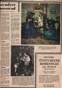
... History House 11 Mackenzie Street Bendigo goldfields HISTORY Australian early farming settlement Lydia Chancellor Collection collection Swan Hill Aboriginal Aboriginal Contact Australia history Australian history homesteads building house houses heritage tourism Aborigines settlers weapons guns pastoralists expedition John Holloway Andrew Beveridge Peter Beveridge Robert O'Hara Burke Narrinyeri Tribe bushrangers relics National Trust advertisement exploration An article from a 'Supplement to Bendigo Advertiser' giving some insights into the history of Tyntyndyer Homestead which is in the Swan Hill district. ...An article from a 'Supplement to Bendigo Advertiser' giving some insights into the history of Tyntyndyer Homestead which is in the Swan Hill district. It gives an insight into the early settlers and their struggles for survival. There is an advertisement within the supplement advertising the 'Historic Tyntyndyer Homestead and Museum.' Coloured and black and white photographs are included in this article which is dated 12/2/1969.history, australian, early farming settlement, lydia chancellor collection, collection, swan hill, aboriginal, aboriginal contact, australia, history, australian history, homesteads, building, house, houses, heritage, tourism, aborigines, settlers, weapons, guns, pastoralists, expedition, john holloway, andrew beveridge, peter beveridge, robert o'hara burke, narrinyeri tribe, bushrangers, relics, national trust, advertisement, exploration -
 Bendigo Historical Society Inc.
Document - BUSH COLLECTION: CORRESPONDENCE TO S A BUSH, 1921-1930
... History House 11 Mackenzie Street Bendigo goldfields PERSON Individual bush collection - personal Bendigo Bush Collection collection business commerce correspondence Correspondence to/from S A Bush: a. to Mr Bush from Frank Holloway, 29/12//30; b. reply to 'Dear Frank' from A Bush (copy); c. from Neal & Woodward to S A Bush, Esq 13/6/1921; d. from Neal & Woodward to S A Bush, Esq. 14/7/1921 Document BUSH COLLECTION: CORRESPONDENCE TO S A BUSH ...Correspondence to/from S A Bush: a. to Mr Bush from Frank Holloway, 29/12//30; b. reply to 'Dear Frank' from A Bush (copy); c. from Neal & Woodward to S A Bush, Esq 13/6/1921; d. from Neal & Woodward to S A Bush, Esq. 14/7/1921person, individual, bush collection - personal, bendigo, bush collection, collection, business, commerce, correspondence -
 Eltham District Historical Society Inc
Document, Conveyance of Lot 20 Henry Street, Little Eltham North to Trustees of Wesleyan Chapel, 1856
... street...i.w. lucas...james blanch...james chapman...james william brown...john jenkins peacock...john jones...john neale...john van mangerhoussen weiss...joseph cooper...joseph morris holloway...Traces the earliest history of the Eltham Public Hall in Henry Street and the various names, occupations and abodes of the Trustees associated with the property aaron grimshaw blacksmith edmond perry eltham public hall eltham rechabite hall eltham wesleyan chapel francis thomas george smith henry street i.w. lucas james blanch james chapman james william brown john jenkins peacock john jones john neale john van mangerhoussen weiss joseph cooper joseph morris holloway josiah atwool keelbundora lancelot iredale little eltham lizar elliott mark blanchard methodist church nicholas rodda p. mather peter dredge rev barnabas shaw walker samuel jeffrey samuel moor munce thomas roberts thomas wheaten bowden william harriman william hebblewhite william john munce william matthews william rose 7 pages typed, letter size Conveyance of Lot 20 Henry Street, Little Eltham North to Trustees of Wesleyan Chapel Document ...Originally purchased in 1856 from Thomas Roberts, Yeoman of Little Eltham, for £10 for use by the Wesleyan Chapel, represented by indentured Trustees, Rev. Barnabas Shaw Walker, Minister of the Pentridge Circuit, Francis Thomas, Farmer of Keelbundora, William Harriman, Blacksmith of Nillumbik, Nicholas Rodda, Farmer of Nillumbik, Aaron Grimshaw, Farmer of Greensborough, Joseph Cooper, Gardener of Keelbundora, Peter Dredge, Scholmaster of Jika Jika and Samuel Jeffrey, Farmer of Jika Jika. Lot 20 of Subdivision of Portion 13, Section 4 of the Parish of Nillumbik in the County of Evelyn was located on the southern side of Henry street in Little Eltham North, where the current Our Lady Help of Christians Catholic Church is situated. It became the location of the Eltham Rechabite Hall. In 1893 a new hall was built and further enlarged in 1919. At the commencement of 1922, the property was purchased from the Independent Order of Rechabites with publicly subscribed funds and a new hall built at a cost of £750 and improved road access constructed to reduce the grade, running from Dudley Street to Henry Street. This hall was eventually replaced with the new Shire Offices and Hall built on the corner of Arthur Street and Main Road, which was opened in 1941. Traces the earliest history of the Eltham Public Hall in Henry Street and the various names, occupations and abodes of the Trustees associated with the propertyaaron grimshaw, blacksmith, edmond perry, eltham public hall, eltham rechabite hall, eltham wesleyan chapel, francis thomas, george smith, henry street, i.w. lucas, james blanch, james chapman, james william brown, john jenkins peacock, john jones, john neale, john van mangerhoussen weiss, joseph cooper, joseph morris holloway, josiah atwool, keelbundora, lancelot iredale, little eltham, lizar elliott, mark blanchard, methodist church, nicholas rodda, p. mather, peter dredge, rev barnabas shaw walker, samuel jeffrey, samuel moor munce, thomas roberts, thomas wheaten bowden, william harriman, william hebblewhite, william john munce, william matthews, william rose -
 Eltham District Historical Society Inc
Document, Certificate of Consent of Sale of Lot 20 Henry Street, Eltham to Hope of Eltham Tent No. 195 Victoria District Independent Order of Rechabites, 28 Nov 1901
... street...hope of eltham tent no. 195...i.w. lucas...isaac hill...james blanch...james chapman...james william brown...john brown...john jenkins peacock...john jones...john neale...john van mangerhoussen weiss...joseph cooper...joseph morris holloway...Traces the earliest history of the Eltham Public Hall in Henry Street and the various names, occupations and abodes of the Trustees associated with the property aaron grimshaw blacksmith edmond perry eltham public hall eltham rechabite hall eltham wesleyan chapel francis thomas george knapman george smith henry street hope of eltham tent no. 195 i.w. lucas isaac hill james blanch james chapman james william brown john brown john jenkins peacock john jones john neale john van mangerhoussen weiss joseph cooper joseph morris holloway josiah atwool keelbundora lancelot iredale little eltham little eltham north lizar elliott mark blanchard methodist church nicholas rodda p. mather peter dredge rev barnabas shaw walker robert david taylor samuel jeffrey samuel moor munce thomas roberts thomas wheaten bowden trustee victoria district independent order of rechabites wesleyan methodist church william harriman william hebblewhite william john munce william john taylor william matthews william rose 6 pages typed, letter size, one with hand written description on reverse Certificate of Consent of Sale of Lot 20 Henry Street, Eltham to Hope of Eltham Tent No. 195 Victoria District Independent Order of Rechabites Document ...Alexander Robert Edgar, President of the Victoria and Tasmania Conference of the Wesleyan Methodist Church by Certificate of Consent of Sale dated 28 November 1901, declared that the Conference of the Church held in Melbourne, 27 February 1894, agreed to the sale by the Trustees of Lot 20 Henry Street. Indenture dated 15 November 1901 between Revd. Barnabas Shaw Walker, Minister of the Pentridge Circuit, Joseph Cooper, Gardener of Keelbundora, Samuel Jeffrey, Farmer of Jika Jika, John Brown, State School Teacher, Robert David Taylor, Gardener and Isaac Hill, Dealer, all of Eltham, the Trustees conveyed the land to William John Taylor the Younger, Gardener, George Knapman, Blacksmith and Isaac Hill junior, Carrier, all of Eltham and Trustees at the time for a Friendly Society known as the Hope of Eltham Tent No. 195 Victoria District Independent Order of Rechabites for the sum of £40. The conveyance was received into the Office of the Registrar General, State of Victoria, 12 December 1901. Originally purchased in 1856 from Thomas Roberts, Yeoman of Little Eltham, for £10 for use by the Wesleyan Chapel, represented by indentured Trustees, Rev. Barnabas Shaw Walker, Minister of the Pentridge Circuit, Francis Thomas, Farmer of Keelbundora, William Harriman, Blacksmith of Nillumbik, Nicholas Rodda, Farmer of Nillumbik, Aaron Grimshaw, Farmer of Greensborough, Joseph Cooper, Gardener of Keelbundora, Peter Dredge, Scholmaster of Jika Jika and Samuel Jeffrey, Farmer of Jika Jika. Lot 20 of Subdivision of Portion 13, Section 4 of the Parish of Nillumbik in the County of Evelyn was located on the southern side of Henry street in Little Eltham North, where the current Our Lady Help of Christians Catholic Church is situated. It became the location of the Eltham Rechabite Hall. In 1893 a new hall was built and further enlarged in 1919. At the commencement of 1922, the property was purchased from the Independent Order of Rechabites with publicly subscribed funds and a new hall built at a cost of £750 and improved road access constructed to reduce the grade, running from Dudley Street to Henry Street. This hall was eventually replaced with the new Shire Offices and Hall built on the corner of Arthur Street and Main Road, which was opened in 1941. Traces the earliest history of the Eltham Public Hall in Henry Street and the various names, occupations and abodes of the Trustees associated with the propertyaaron grimshaw, blacksmith, edmond perry, eltham public hall, eltham rechabite hall, eltham wesleyan chapel, francis thomas, george knapman, george smith, henry street, hope of eltham tent no. 195, i.w. lucas, isaac hill, james blanch, james chapman, james william brown, john brown, john jenkins peacock, john jones, john neale, john van mangerhoussen weiss, joseph cooper, joseph morris holloway, josiah atwool, keelbundora, lancelot iredale, little eltham, little eltham north, lizar elliott, mark blanchard, methodist church, nicholas rodda, p. mather, peter dredge, rev barnabas shaw walker, robert david taylor, samuel jeffrey, samuel moor munce, thomas roberts, thomas wheaten bowden, trustee, victoria district independent order of rechabites, wesleyan methodist church, william harriman, william hebblewhite, william john munce, william john taylor, william matthews, william rose -
 Eltham District Historical Society Inc
Postcard - Photograph postcard, Old Bridge, Kaylock's Crossing, Brougham Street, Eltham, c.1912
... t=115) Brougham Street was created in Josiah Holloway's 1851 subdivision of Little Eltham. ...t=115) Brougham Street was created in Josiah Holloway's 1851 subdivision of Little Eltham. ...Date estimated to be circa 1912 based on the style of printing on the reverse of the card - Kodak Austral paper for real photo postcards, the paper was manufactured c.1908-1914 (See also POSTCARDS ON KODAK PAPER - IS IT POSSIBLE TO "DATE" THEM? http://tps.org.au/bb/viewtopic.php?t=115) Brougham Street was created in Josiah Holloway's 1851 subdivision of Little Eltham. It was one of several east-west streets shown on the subdivision plan as crossing the Diamond Creek. The western part was named Wellington Street on the subdivision plan but was later changed to conform with the name of the eastern part as acknowledgement of the continuity of the street. It is not known when the first bridge was constructed in Brougham Street however it was certainly mentioned at Council’s meeting of 2 June 1884 as being in a dangerous state of repair. This photo (c.1895) of an old bridge shows a very low-level simple log girder bridge crossing the creek at a right angle and so the approaches involved bends in the road alignment. This bridge was generally known as Kaylocks Bridge or Kaylock’s Crossing after the owner of the adjoining land. It was most likely built from around the mid-1850s, or a crossing of some fashion established as Richard George Kaylock, butcher of Little Eltham and his wife Emily Ann settled there in 1854. His property was in Wellington Street (now Brougham Street) and apparently extended across the Diamond Creek. The land on the western side of the creek was farmed, the house being on the eastern side. Kaylock's Bridge formed part of the original coach road to Eltham and in 1922 was described as an "old rustic bridge". Its low level and insubstantial construction made it susceptible to flood damage, necessitating frequent closures until repairs could be carried out. In September 1922, Council called for tenders for a new timber bridge to be constructed at Kaylock’s crossing. An engineering assessment carried out for the Council by Macleod Consulting at the time of the replacement suggested that the construction details indicate that it was in the 1900s, however this dating could possibly have been the result of numerous repairs undertaken over the years to flood damage. The tender was awarded to Mr Weller of Kangaroo Ground who commenced work in February 1923 on a higher-level timber trestle bridge. Work was slowed due to illness of the contractor and the accidental death of a man in March 1923 following the collapse of the bank after he had jumped into a hole that had just been blasted. The bridge was completed around July 1923 at which point the old structure was pulled up, marking what was described in the ‘Advertiser’ newspaper as the passing of an old and well-loved landmark in the district. In April 1924 the approach to Kaylocks bridge was washed away during the heavy flooding that destroyed the Main Road bridge. The western side was repaired, and an extra span was added to the eastern side using timber from the destroyed Main Road bridge. The bridge was again severely damaged four months later in August 1924 When a lack of finances delayed repairs to the Bridge Street bridge in 1931 (also referred to as Obelisk Bridge at the time), traffic had to detour via Brougham Street for some time. Local residents feared that the Bridge Street bridge might never reopen. Kaylocks Bridge was constantly subject to damage by floods. In the 1934 flood it was submerged by two feet of water. In more recent times the bridge was again severely damaged by flooding and repairs made. A new bridge and adjoining footbridge were constructed in 2009.Digital file only Postcards scanned from the collection of Michael Aitken on loan to EDHS, 2 Sep. 2022michael aitken collection, eltham, postcards, bridge, brougham street, diamond creek (creek), kaylocks bridge, wellington street -
 Eltham District Historical Society Inc
Photograph - Colour Print, Belle Vue, Livingstone Road, Eltham, c.2015
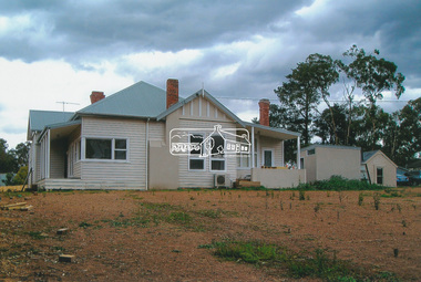
... Holloway’s 1851 Little Eltham subdivision. On the present day map the southern boundary was just north of Elsa Court and Grove Street. ...Holloway’s 1851 Little Eltham subdivision. On the present day map the southern boundary was just north of Elsa Court and Grove Street. ...Belle Vue property in Livingstone Road, Eltham was once owned by Society member Jo McCormick. Jo was a valued member of our committee and dear friend of many of our members until her death in 2009. Belle Vue is the farmhouse of a property that is now a significant part of suburban Eltham, just a short distance north of the town centre. Originally purchased by pioneer Eltham farmer Henry Stooke, the present-day old farmhouse sits within an extensive suburban residential area. The history of the property is largely based on a heritage assessment prepared by consultant Lorraine Huddle for Nillumbik Shire Council. Additional information from our Society records reveals Belle Vue farm comprised about 56 ha (140 acres) extending northerly from the northern boundary of Holloway’s 1851 Little Eltham subdivision. On the present day map the southern boundary was just north of Elsa Court and Grove Street. The western boundary was the Diamond Creek and extended northerly to Main Road where it turns easterly towards Research. It was traversed by the main road to Kangaroo Ground and beyond and from 1912 by the railway to Hurstbridge. From 1895 the farm was owned by William Williams and his wife Mary Ann. In 1914 -15 they built a new house now known as Belle Vue. They sold the land in 1920 and residential subdivision began soon after that. Belle Vue remains today on a substantially subdivided and very much reduced size residential lot in Livingstone Road. The house and many old trees on the site were subject to a heritage overlay under the Nillumbik Planning Scheme. Despite that overlay, the development and subdivision of the original land resulted in most of the heritage listed trees being removed. belle vue, eltham, livingstone road -
 Eltham District Historical Society Inc
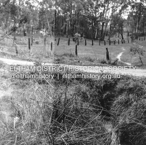
Negative - Photograph, J.A. McDonald, Fordhams Road, Eltham, 24 July 1962
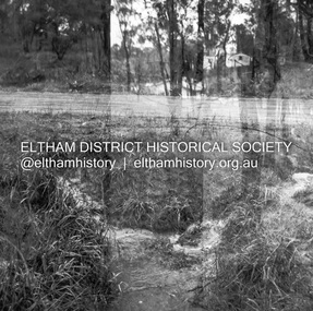
... Culvert discharging towards land owned by Holloway & Spicer about 3pm on 24 July 1962 Heavy rain 60 years later it still appears to present as a concern - see Google Street View (Nov 2021) https://goo.gl/maps/x61yWvAc5UjJ2d8y9...Eltham District Historical Society Inc 728 Main Rd Eltham melbourne Culvert discharging towards land owned by Holloway & Spicer about 3pm on 24 July 1962 Heavy rain 60 years later it still appears to present as a concern - see Google Street View (Nov 2021) https://goo.gl/maps/x61yWvAc5UjJ2d8y9 Record of various Shire of Eltham infrastructure works undertaken during the period of 1952-1962 involving bridge and road reconstruction projects, sometimes with Eltham Shire Council Project Reference numbers quoted. ...Culvert discharging towards land owned by Holloway & Spicer about 3pm on 24 July 1962 Heavy rain 60 years later it still appears to present as a concern - see Google Street View (Nov 2021) https://goo.gl/maps/x61yWvAc5UjJ2d8y9Record of various Shire of Eltham infrastructure works undertaken during the period of 1952-1962 involving bridge and road reconstruction projects, sometimes with Eltham Shire Council Project Reference numbers quoted. It was during this period that a number of significant improvements were made to roads and new bridges constructed within the shire that remain in place as of present day (2022). In many situations, the photos provide a tangible visible record of infrastructure that existed throughout the early days of the Shire. The album was put together by or under the direction of the Shire Engineer, J.A. McDonald.1962-07-24, culvert, eltham, fordhams road, infrastructure, shire of eltham -
 Eltham District Historical Society Inc
Negative - Photograph, J.A. McDonald, Fordhams Road, Eltham, 24 July 1962
... Culvert discharging towards land owned by Holloway & Spicer about 3pm on 24 July 1962 Heavy rain 60 years later it still appears to present as a concern - see Google Street View (Nov 2021) https://goo.gl/maps/x61yWvAc5UjJ2d8y9...Eltham District Historical Society Inc 728 Main Rd Eltham melbourne Culvert discharging towards land owned by Holloway & Spicer about 3pm on 24 July 1962 Heavy rain 60 years later it still appears to present as a concern - see Google Street View (Nov 2021) https://goo.gl/maps/x61yWvAc5UjJ2d8y9 Record of various Shire of Eltham infrastructure works undertaken during the period of 1952-1962 involving bridge and road reconstruction projects, sometimes with Eltham Shire Council Project Reference numbers quoted. ...Culvert discharging towards land owned by Holloway & Spicer about 3pm on 24 July 1962 Heavy rain 60 years later it still appears to present as a concern - see Google Street View (Nov 2021) https://goo.gl/maps/x61yWvAc5UjJ2d8y9Record of various Shire of Eltham infrastructure works undertaken during the period of 1952-1962 involving bridge and road reconstruction projects, sometimes with Eltham Shire Council Project Reference numbers quoted. It was during this period that a number of significant improvements were made to roads and new bridges constructed within the shire that remain in place as of present day (2022). In many situations, the photos provide a tangible visible record of infrastructure that existed throughout the early days of the Shire. The album was put together by or under the direction of the Shire Engineer, J.A. McDonald.1962-07-24, culvert, eltham, fordhams road, infrastructure, shire of eltham -
 Eltham District Historical Society Inc
Photograph, Peter Pidgeon, Eltham War Memorial, 903-907 Main Road, Eltham, 4 November 2017, 4 Nov 2017
... Holloway’s 1851 Little Eltham subdivision. It was originally 30 acres in area and situated east of the Diamond Creek and north of Henry Street....Holloway’s 1851 Little Eltham subdivision. It was originally 30 acres in area and situated east of the Diamond Creek and north of Henry Street. ...Eltham District Historical Society heritage walk to follow the boundaries of the original Shillinglaw Farm in central Eltham, held Saturday, 4th November, 2017. The Shillinglaw Farm comprised Lot 90 of Holloway’s 1851 Little Eltham subdivision. It was originally 30 acres in area and situated east of the Diamond Creek and north of Henry Street.Born digital imageeltham war memorial, obelisk, war memorial buidings, war memorial hall