Showing 82 items matching " hume highway"
-
 Wodonga & District Historical Society Inc
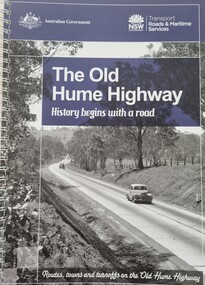
Book - The Old Hume Highway - History begins with a Road, 2014
... The Old Hume Highway - History begins with a Road...The Old Hume Highway - History begins with a Road...Old Hume Highway...A spiral bound volume of 122 pages including maps, photographs and illustrations prepared as a travel guide to the Old Hume Highway. It includes a Foreword by Peter FitzSimons....Wodonga & District Historical Society Inc Hut 97, Bonegilla Migrant Experience, 132 Bonegilla Road Bonegilla the-murray This publication is significant because it highlights the location and history of small towns along the New South Wales section of the Hume Highway. Old Hume Highway hume highway Travel Guide Hume Highway \ The Hume Highway was officially named in 1928, when both the New South Wales and Victorian governments agreed to give the unified inland route between Sydney and Melbourne the name, honouring explorer Hamilton Hume who, with William Hovell, first found the overland path in 1824. ...The Hume Highway was officially named in 1928, when both the New South Wales and Victorian governments agreed to give the unified inland route between Sydney and Melbourne the name, honouring explorer Hamilton Hume who, with William Hovell, first found the overland path in 1824. Much of the original highway followed their overland route wherever the landscape allowed. The road connected many small communities and rural properties, although in many parts was narrow and unsurfaced. Over the following years alterations and some deviations occurred with changing transport needs and heavier traffic loads. One of these deviations was completed in 1933 at Table Top north of Albury between Ettamogah and Mullengandra due to the construction of the Hume Weir which flooded the existing highway. Gradually sections of the road were converted to a dual carriageway. In 1961 the first modern freeway-standard, four-lane section was completed in Victoria at Craigieburn. The Hume Highway was also rerouted in Albury to avoid the town centre. Many major bypasses and duplications in New South Wales were completed throughout the 1980s and 1990s. In 1994 the last section of the Hume Highway in Victoria was duplicated with the completion of the Wangaratta bypass. The Albury-Wodonga bypass was opened in 2007 and in 2013 the final section, the Holbrook Bypass in NSW, was opened to traffic on August 7, completing the full Sydney-Melbourne dual carriageway link. In the course of this gigantic engineering achievement, many small, historic towns throughout Victoria and New South Wales were bypassed and often forgotten by passing commuters in a rush to reach their destination. This publication includes maps and information about the sites and landmarks in these towns. It encourages travellers to venture of the modern highway and rediscover the Old Hume Highway and the stories it holds about out past.A spiral bound volume of 122 pages including maps, photographs and illustrations prepared as a travel guide to the Old Hume Highway. It includes a Foreword by Peter FitzSimons.The Hume Highway was officially named in 1928, when both the New South Wales and Victorian governments agreed to give the unified inland route between Sydney and Melbourne the name, honouring explorer Hamilton Hume who, with William Hovell, first found the overland path in 1824. Much of the original highway followed their overland route wherever the landscape allowed. The road connected many small communities and rural properties, although in many parts was narrow and unsurfaced. Over the following years alterations and some deviations occurred with changing transport needs and heavier traffic loads. One of these deviations was completed in 1933 at Table Top north of Albury between Ettamogah and Mullengandra due to the construction of the Hume Weir which flooded the existing highway. Gradually sections of the road were converted to a dual carriageway. In 1961 the first modern freeway-standard, four-lane section was completed in Victoria at Craigieburn. The Hume Highway was also rerouted in Albury to avoid the town centre. Many major bypasses and duplications in New South Wales were completed throughout the 1980s and 1990s. In 1994 the last section of the Hume Highway in Victoria was duplicated with the completion of the Wangaratta bypass. The Albury-Wodonga bypass was opened in 2007 and in 2013 the final section, the Holbrook Bypass in NSW, was opened to traffic on August 7, completing the full Sydney-Melbourne dual carriageway link. In the course of this gigantic engineering achievement, many small, historic towns throughout Victoria and New South Wales were bypassed and often forgotten by passing commuters in a rush to reach their destination. This publication includes maps and information about the sites and landmarks in these towns. It encourages travellers to venture of the modern highway and rediscover the Old Hume Highway and the stories it holds about out past.old hume highway, hume highway, travel guide hume highway, \ -
 Wodonga & District Historical Society Inc
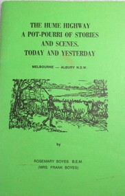
Book - The Hume Highway: A Potpourri of Stories and Scenes Today and Yesterday, Rosemary Boyes, 1978
... The Hume Highway: A Potpourri of Stories and Scenes Today and Yesterday...The Hume Highway: A Potpourri of Stories and Scenes Today and Yesterday......hume highway...The Hume Highway: A Potpourri of Stories and Scenes Today and Yesterday Book The Hume Highway: A Potpourri of Stories and Scenes Today and Yesterday Rosemary Boyes ...A collection of anecdotes from travel along the Hume Highway from Melbourne, Victoria to Albury, NSW.non-fictionA collection of anecdotes from travel along the Hume Highway from Melbourne, Victoria to Albury, NSW.albury, melbourne, hume highway, travel victoria, anecdotes and pioneer stories -
 Broadmeadows Historical Society & Museum
Photograph - Fatal Accident, Leader newspaper, 16 September 1986
... ...Hume Highway...Fatal accident Somerton Road and Hume Highway 1986...Cnr Somerton Road and Hume Highway, Somerton, Australia...Broadmeadows Historical Society & Museum 21 Pearcedale Parade Broadmeadows melbourne Fatal accident Somerton Road and Hume Highway 1986 Event in Somerton Fatal accident Hume Highway Somerton Road Somerton Broadmeadows Observer Obs 17//9/86; P1; Pascoe Vale Road crash Leader Newspaper stamp Photo b/w: 17.5 cm x 12 cm Photograph Fatal Accident Leader newspaper ...Fatal accident Somerton Road and Hume Highway 1986Event in SomertonPhoto b/w: 17.5 cm x 12 cmObs 17//9/86; P1; Pascoe Vale Road crash Leader Newspaper stampfatal accident, hume highway, somerton road, somerton, broadmeadows observer -
Lakes Entrance Historical Society
Book, Boyes, Rosemary B.E.M, The Hume Highway Today and Yesterday 1978, 1978
... The Hume Highway Today and Yesterday 1978...Stories and photographs illustrating a little of the Hume Highway between Melbourne and Albury...Stories and photographs illustrating a little of the Hume Highway between Melbourne and Albury The Hume Highway Today and Yesterday 1978 Book Boyes, Rosemary B.E.M. ...Stories and photographs illustrating a little of the Hume Highway between Melbourne and AlburyCopy of inscription in Sutherland family history file.roads and streets -
Whitehorse Historical Society Inc.
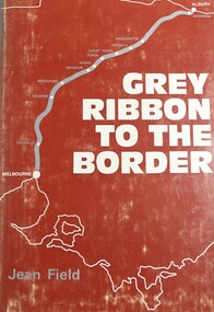
Book, Grey ribbon to the border, 1973
... hume highway...History of the Hume Highway...Whitehorse Historical Society Inc. 2-10 Deep Creek Road Mitcham melbourne hume highway victoria History of the Hume Highway History of the Hume Highway Grey ribbon to the border Book Book ...History of the Hume HighwayHistory of the Hume HighwayHistory of the Hume Highwayhume highway, victoria -
 Ringwood RSL Sub-Branch
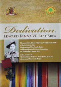
Booklet - Dedication of rest area in Honour of Edward Kenna. VC, Pheasants nest, Hume Highway (Northbound) N.S.W
... Pheasants nest, Hume Highway (Northbound) N.S.W...Ringwood RSL Sub-Branch 16 Station Street Ringwood melbourne Pheasants nest, Hume Highway (Northbound) N.S.W Booklet Dedication of rest area in Honour of Edward Kenna. ... -
 Robin Boyd Foundation
Document - Manuscript, Robin Boyd, The Night Between Cities, 1963
... ... Hume Highway...A pointed critique of having two competing cities, Melbourne and Sydney, and the experience of driving the Hume Highway, staying at motels....Sydney Melbourne motels Hume Highway Robin Boyd manuscript Typewritten (c copy), foolscap, 7 pages. ...A pointed critique of having two competing cities, Melbourne and Sydney, and the experience of driving the Hume Highway, staying at motels.Published as "The night between cities" in "London Magazine" (London), Vol.3, July 1963, pp. 45-50.Typewritten (c copy), foolscap, 7 pages. (Two copies)sydney, melbourne, motels, hume highway, robin boyd, manuscript -
 Wodonga & District Historical Society Inc
Book - Grey Ribbon to the Border, Jean Field, 1973
... victoria. countryside adjacent to the hume highway....Wodonga & District Historical Society Inc Hut 97, Bonegilla Migrant Experience, 132 Bonegilla Road Bonegilla the-murray victoria. countryside adjacent to the hume highway. description and travel victoria hume highway victoria A detailed description of towns and area adjacent to the Hume Highway between Melbourne, Victoria and Albury, NSW Grey Ribbon to the Border Book Grey Ribbon to the Border Jean Field ...A detailed description of towns and area adjacent to the Hume Highway between Melbourne, Victoria and Albury, NSWnon-fictionA detailed description of towns and area adjacent to the Hume Highway between Melbourne, Victoria and Albury, NSWvictoria. countryside adjacent to the hume highway., description and travel victoria, hume highway victoria -
 Wodonga & District Historical Society Inc
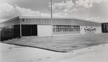
Photograph - The Sarah Coventry Pty. Ltd. building in Wodonga, Victoria, c. 1969
... It was built in 1969 at Sarah Coventry Park, Hume Highway, Wodonga....It was built in 1969 at Sarah Coventry Park, Hume Highway, Wodonga. The Sarah Coventry Pty. ...Sarah Coventry Pty. Ltd. was a North American jewellery company that was established in 1949 by the Stuart family as part of Emmons Jewelry, Inc. It began operations in England and Australia in 1968, and in Australia it moved from Carlton in Melbourne to Wodonga in 1969. The premises were originally on High Street in Wodonga, but a new warehouse was built in Melbourne Road later in 1969. It was a direct selling jewellery business using a party-plan model similar to Tupperware and Avon. The sales reps or 'Hostesses' were provided with jewellery samples in demonstration kits, which they displayed at jewellery parties in their homes. The designs for jewellery such as brooches, necklaces, earrings, chokers and bracelets were purchased from freelance designers and jewellery manufacturers rather than in-house designers. In 1979 Sarah Coventry Pty. Ltd. in Wodonga was bought by three Australian businessmen, including Wodonga local Jim Sawyer, and continued to sell jewellery under the name "Sargem Pty. Ltd”, for several more years in the 1980s. The black and white photograph of the 1969 Sarah Coventry Pty. Ltd. warehouse in Wodonga has local significance as part of the decentralised commercial development of regional centres such as Wodonga in NE Victoria. As part of the Sarah Coventry collection, the photograph has national and international significance from the perspective of social and economic developments for women after World War II. The direct selling party-plan business model it was based on is also considered the first of its kind for jewellery.Black and white photographic print of the outside of the Sarah Coventry Pty. Ltd. building in Wodonga, Victoria. It was built in 1969 at Sarah Coventry Park, Hume Highway, Wodonga.The name "Sarah Coventry" is on the front wall of the building in the photo.sarah coventry, jewellery, wodonga, costume jewellery, vintage fashion jewellery -
Beechworth Honey Archive
Map- Chiltern/Barnawartha
... Shows Murray River, Hume Highway, Chiltern- Barnawartha Rd and Chiltern- Rutherglen Rd. ...Shows Murray River, Hume Highway, Chiltern- Barnawartha Rd and Chiltern- Rutherglen Rd. ...(4x) Map centred on Chiltern and Barnawartha. Shows Murray River, Hume Highway, Chiltern- Barnawartha Rd and Chiltern- Rutherglen Rd. Scale 1:50,000. Paper is white on back, yellow on front.Map labelled 'Albury series R652' Some markings in red and blue on some maps- blue writes '74-75'map, chiltern, barnawartha, paper, beechworth honey -
 Greensborough Historical Society
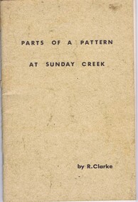
Booklet, Ruth Clarke, Parts of a pattern at Sunday Creek, 1971
... Historical notes on the community of Sunday Creek, south of Broadford off the Hume Highway in Victoria...Greensborough Historical Society 34A Glenauburn Road Lower Plenty Lower Plenty melbourne Historical notes on the community of Sunday Creek, south of Broadford off the Hume Highway in Victoria sunday creek victoria broadford 45 p., black and white illustrations Parts of a pattern at Sunday Creek Booklet Booklet Ruth Clarke Ajax Printing & Duplicating Pty Ltd ...Historical notes on the community of Sunday Creek, south of Broadford off the Hume Highway in Victoria45 p., black and white illustrationssunday creek, victoria, broadford -
Beechworth Honey Archive
Map- Albury/Wodonga
... Shows Albury and Wodonga, Murray River, Hume Highway, Murray Valley Highway and Riverina Highway. ...Shows Albury and Wodonga, Murray River, Hume Highway, Murray Valley Highway and Riverina Highway. ...(5x) Map centred on Albury and Wodonga. Shows Albury and Wodonga, Murray River, Hume Highway, Murray Valley Highway and Riverina Highway. Scale 1:50,000. Paper is white on back and yellow on front. Ca 1974-1975 Labelled 'Albury series R 652'map, albury, wodonga, paper, beechworth honey -
 Wodonga & District Historical Society Inc
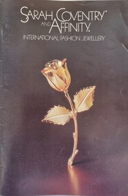
Booklet - Sarah Coventry Affinity Range Catalogue 1982
... Business contact details on the back cover use the company name "Sar*Gem Pty Ltd", Hume Highway Wodonga....Business contact details on the back cover use the company name "Sar*Gem Pty Ltd", Hume Highway Wodonga. Sarah Coventry Affinity Range Catalogue 1982 Booklet Sarah Coventry Affinity Range Catalogue 1982 ...Historical information Sarah Coventry Pty. Ltd. was a North American jewellery company that was established in 1949 by the Stuart family as part of Emmons Jewelry, Inc. It began operations in England and Australia in 1968, and in Australia it moved from Carlton in Melbourne to Wodonga in 1969. The premises were originally on High Street in Wodonga, but a new warehouse was built in Melbourne Road later in 1969. It was a direct selling jewellery business using a party-plan model similar to Tupperware and Avon. The sales reps or 'Hostesses' were provided with jewellery samples in demonstration kits, which they displayed at jewellery parties in their homes. The designs for jewellery such as brooches, necklaces, earrings, chokers and bracelets were purchased from freelance designers and jewellery manufacturers rather than in-house designers. In 1979 Sarah Coventry Pty. Ltd. in Wodonga was bought by three Australian businessmen, including Wodonga local Jim Sawyer, and continued to sell jewellery under the name "Sar*gem Pty. Ltd”, for several more years in the 1980s, along with a new range of fashion jewellery, Affinity. This catalogue was produced by Sar*gem Pty Ltd in 1982As part of the Sarah Coventry collection, the catalogue has local significance connected to the decentralised commercial development of regional centres such as Wodonga in NE Victoria, as well as national and international significance from the perspective of social and economic developments for women after World War II. The direct selling party-plan business model Sarah Coventry was based on is also considered the first of its kind for jewellery. A coloured catalogue promoting the Affinity Jewellery line released in 1982. The back cover features a fundraising campaign for the Guide Dog Association. Business contact details on the back cover use the company name "Sar*Gem Pty Ltd", Hume Highway Wodonga.sarah coventry, sarah coventry wodonga, sarah coventry affinity -
 Wodonga & District Historical Society Inc
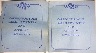
Booklet - Caring for your Sarah Coventry and Affinity Jewellery
... On Front cover: CARING FOR YOUR SARAH COVENTRY AND AFFINITY JEWELLERY On back cover: Sargem Pty. Ltd. / Hume Highway/ WODONGA VIC, 3690 / Copyright 1979 Inside: detailed cleaning instruction...Sarah Coventry costume jewellery Industry Wodonga On Front cover: CARING FOR YOUR SARAH COVENTRY AND AFFINITY JEWELLERY On back cover: Sargem Pty. Ltd. / Hume Highway/ WODONGA VIC, 3690 / Copyright 1979 Inside: detailed cleaning instruction A small leaflet printed on blue paper in blue ink explaining instructions for caring for items from the Sarah Coventry range Caring for your Sarah Coventry and Affinity Jewellery Booklet Caring for your Sarah Coventry and Affinity Jewellery ...Sarah Coventry Pty. Ltd. was a North American jewellery company that was established in 1949 by the Stuart family as part of Emmons Jewelry, Inc. It began operations in England and Australia in 1968, and in Australia it moved from Carlton in Melbourne to Wodonga in 1969. The premises were originally on High Street in Wodonga, but a new warehouse was built in Melbourne Road later in 1969. It was a direct selling jewellery business using a party-plan model similar to Tupperware and Avon. The sales reps or 'Hostesses' were provided with jewellery samples in demonstration kits, which they displayed at jewellery parties in their homes. The designs for jewellery such as brooches, necklaces, earrings, chokers and bracelets were purchased from freelance designers and jewellery manufacturers rather than in-house designers. In 1979 Sarah Coventry Pty. Ltd. in Wodonga was bought by three Australian businessmen, including Wodonga local Jim Sawyer, and continued to sell jewellery under the name "Sargem Pty. Ltd”, for several more years in the 1980s.As part of the Sarah Coventry collection, the necklace has local significance with the decentralised commercial development of regional centres such as Wodonga in NE Victoria, as well as national and international significance from the perspective of social and economic developments for women after World War II. The direct selling party-plan business model Sarah Coventry was based on is also considered the first of its kind for jewellery.A small leaflet printed on blue paper in blue ink explaining instructions for caring for items from the Sarah Coventry rangeOn Front cover: CARING FOR YOUR SARAH COVENTRY AND AFFINITY JEWELLERY On back cover: Sargem Pty. Ltd. / Hume Highway/ WODONGA VIC, 3690 / Copyright 1979 Inside: detailed cleaning instructionsarah coventry, costume jewellery, industry wodonga -
 Wodonga & District Historical Society Inc
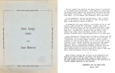
Booklet - Collection of Local History Booklets, Rosemary Boyes B.E.M
... Albury - Murray River to Botanic Gardens 3. The Hume Highway - A potpourri of Stories and Scenes, Today and Yesterday 4. ...Albury - Murray River to Botanic Gardens 3. The Hume Highway - A potpourri of Stories and Scenes, Today and Yesterday 4. ...In 1976 Rosemary Boyes was awarded the British Empire Medal for services to Australian History. She was the author of more than 20 publications about local and national historical events. From 1970 to 1981, writing as Mrs Frank Boyes, she contributed a regular column to the Wodonga/Albury Express newspaper. Rosemary was a Founder Member of the Albury & District Historical Society in 1961, a Life Member of Wodonga & District Historical Society and also a Life Member of the Wodonga RSL Sub-Branch. She and her husband, Frank, a veteran of the Kokoda Trail, farmed at Leneva before moving to Albury and then to Frankston. Rosemary Boyes died in September 1991.A collection of small paper back booklets on a range of topics related to Albury and Wodonga history. Their titles are:- 1. "Violet Grange Leneva" and its History 2. Albury - Murray River to Botanic Gardens 3. The Hume Highway - A potpourri of Stories and Scenes, Today and Yesterday 4. The Hume Monument - Albury NSW 5. Remembering Robert BrownIn 1976 Rosemary Boyes was awarded the British Empire Medal for services to Australian History. She was the author of more than 20 publications about local and national historical events. From 1970 to 1981, writing as Mrs Frank Boyes, she contributed a regular column to the Wodonga/Albury Express newspaper. Rosemary was a Founder Member of the Albury & District Historical Society in 1961, a Life Member of Wodonga & District Historical Society and also a Life Member of the Wodonga RSL Sub-Branch. She and her husband, Frank, a veteran of the Kokoda Trail, farmed at Leneva before moving to Albury and then to Frankston. Rosemary Boyes died in September 1991. australian history, rosemary boyes bem -
 Wodonga & District Historical Society Inc
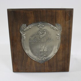
Plaque - Wodonga Golf Club Plaque
... It was demolished in 1987 to make room for the new Hume Highway. This plaque was salvaged from the club house building before demolition. ...It was demolished in 1987 to make room for the new Hume Highway. This plaque was salvaged from the club house building before demolition. ...A commemorative plaque from the old Wodonga Golf House, built in 1946. The club house and the golf course were extended in 1956 to the area of Belvoir Park. It was demolished in 1987 to make room for the new Hume Highway. This plaque was salvaged from the club house building before demolition. This item has a strong link to the local and sporting history of Wodonga.A wooden plaque with engraved metal plate depicting a male golfer attached. gold, sport, leisure, entertainment, wodonga, wodonga golf club -
 Broadmeadows Historical Society & Museum
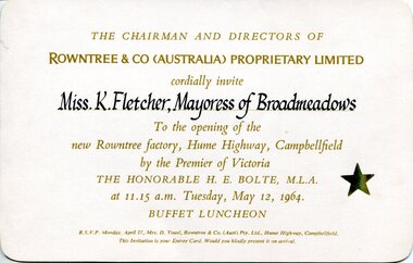
Ephemera - Invitation, Rowntree & Co. (Australia) Proprietary Limited, Invitation to opening of new Rowntree factory, Campbellfield, 1964
... (Aust) Pty. Ltd., Hume Highway, Campbellfield. / This Invitation is your Entree Card. ...(Aust) Pty. Ltd., Hume Highway, Campbellfield. / This Invitation is your Entree Card. ...The invitation documents the opening of Rowntree & Co. (Australia)’s Campbellfield factory in 1964, officiated by the Premier of Victoria. It demonstrates post‑war industrial expansion in Melbourne’s northern suburbs and highlights civic–corporate relationships through the invitation of the local Mayoress.This item has local historic significance for Broadmeadows and Campbellfield, providing primary evidence of major industrial development and civic engagement in Victoria during the 1960s.Rectangular printed card with rounded corners. Cream/light buff cardstock. Recto printed in gold and black ink; verso blank except for later applied catalogue label.Recto (centre): “THE CHAIRMAN AND DIRECTORS OF / ROWNTREE & CO (AUSTRALIA) PROPRIETARY LIMITED / cordially invite / Miss K. Fletcher, Mayoress of Broadmeadows / To the opening of the / new Rowntree factory, Hume Highway, Campbellfield / by the Premier of Victoria / THE HONORABLE H. E. BOLTE, M.L.A. / at 11.15 a.m. Tuesday, May 12, 1964. / BUFFET LUNCHEON” (lower margin): “R.S.V.P. Monday, April 27, Mrs. D. Youel, Rowntree & Co. (Aust) Pty. Ltd., Hume Highway, Campbellfield. / This Invitation is your Entree Card. Would you kindly present it on arrival.” Recto (right): Gold star motif Verso (upper right): “WI 4054” (typed label)industrial development, campbellfield (vic.), broadmeadows (vic.), corporate events, manufacturing history, local government representation -
 Bendigo Historical Society Inc.
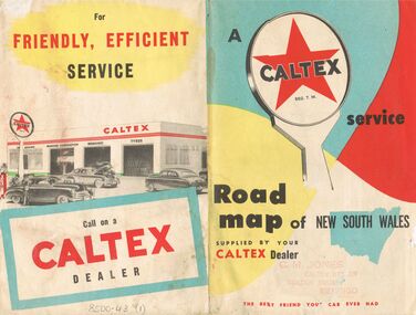
Document - J W SWATTON COLLECTION: MAP OF NEW SOUTH WALES
... It also lists the Principal Towns with Distances from Sydney and Interstate Road Mileages including Sydney to Melbourne via Hume Highway, Prince's Highway, via Canberra & Bombala. ...It also lists the Principal Towns with Distances from Sydney and Interstate Road Mileages including Sydney to Melbourne via Hume Highway, Prince's Highway, via Canberra & Bombala. ...Two Road maps of New South Wales. C M Jones, Caltex Dealer, Golden Square, Bendigo stamped on the front. Map shows Sydney Outlet Roads, City of Sydney, City of canberra, Newcastle District, Motor tours Around Sydney, Routes to Brisbane, Road Map of New South Wales. It also lists the Principal Towns with Distances from Sydney and Interstate Road Mileages including Sydney to Melbourne via Hume Highway, Prince's Highway, via Canberra & Bombala. Also Sydney to Adelaide via Hume & Sturt Highways, Sydney to Brisbane via New England Highway, Pacific Highway via Toowoomba and Sydney to Adelaide via Western, Mid-Western and Sturt Highways.person, receipts, j w swatton, j w swatton collection, road map of new south wales, caltex, c m jones, e s sculley, clive barrass -
 Melbourne Tram Museum
Newspaper, The Sun, “A tram off the tracks”, 22/10/1977 12:00:00 AM
... “A tram off the tracks” The Sun, Saturday, Oct 22, 1977 Photos and text Tram # 86 Photos of tram # 86 being transported on semi-trailer on Hume Highway at Beveridge on its way to Orange, NSW. ...Melbourne Tram Museum 8 Wallen Road Hawthorn melbourne Trams tramways Displays Trucks Z class Transporting Trams tram 86 “A tram off the tracks” The Sun, Saturday, Oct 22, 1977 Photos and text Tram # 86 Photos of tram # 86 being transported on semi-trailer on Hume Highway at Beveridge on its way to Orange, NSW. ...“A tram off the tracks” The Sun, Saturday, Oct 22, 1977 Photos and text Tram # 86 Photos of tram # 86 being transported on semi-trailer on Hume Highway at Beveridge on its way to Orange, NSW. Part of display by Bathurst-Orange Development Corporation, planning to build a new town between the two cities. Trams among the different types of transport being considered to link the proposed town to its neighbours. Tram displays “Brunswick-Moreland Rd” and route number 954.trams, tramways, displays, trucks, z class, transporting trams, tram 86 -
 Orbost & District Historical Society
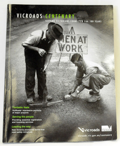
book, Vic Roads Centenary 1913 -2013, 2013
... Written by current and former VicRoads’ employees, the publication details the organisation’s portfolio of major projects, which includes the Great Ocean Road, Hume Highway and Eastern Freeway. Other sections report on Victoria’s world-first road safety initiatives, VicRoads’ use of technology and sustainability measures. ...Written by current and former VicRoads’ employees, the publication details the organisation’s portfolio of major projects, which includes the Great Ocean Road, Hume Highway and Eastern Freeway. Other sections report on Victoria’s world-first road safety initiatives, VicRoads’ use of technology and sustainability measures. ...The publication, VicRoads Centenary: Keeping Victorians Connected for 100 Years, looks at the people and projects that define VicRoads’ history. Written by current and former VicRoads’ employees, the publication details the organisation’s portfolio of major projects, which includes the Great Ocean Road, Hume Highway and Eastern Freeway. Other sections report on Victoria’s world-first road safety initiatives, VicRoads’ use of technology and sustainability measures. (ref VicRoads) This item is one of several books donated by David Jellie at a presentation to Orbost Historical Society. He was a contributor to the book and was the engineer for the Snowy River Bridge (Princes Highway) at Orbost 1974-1976.This book is a useful reference tool on the history of road construction in Victoria including East Gippsland.A thick, bound paperback book, titled "VicRoads Centenary Keeping Victorians Connected for 100 Years". On the front cover is a black/white photograph of two men working on a road. One has a pick. The book contains the history of VicRoads, photographs, maps and advertisements. Some are b/w. Others are coloured.vicroads book roads snowy-river-bridge jellie-david -
 Wodonga & District Historical Society Inc
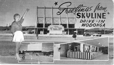
Photograph - Skyline Drive-in, Wodonga, 1956 - 1985
... This allowed it to operate during the day to cater to travellers passing on the Hume Highway. When Hoyts decided to sell most of the regional circuit, the Skyline was purchased by the operator of the Albury Cinema, Mr A. ...This allowed it to operate during the day to cater to travellers passing on the Hume Highway. When Hoyts decided to sell most of the regional circuit, the Skyline was purchased by the operator of the Albury Cinema, Mr A. ...Inspired by a visit to the USA in the early 1950s, Hoyts' Southern Division manager George Griffith Jnr, formed a syndicate to build Australia’s first Drive-in located in Burwood. Drive-ins soon spread throughout the country. One of the earliest Skyline Drive-ins in rural Victoria was built in Wodonga, opening in 1956. It was located on the southwest corner of Melrose Drive and Melbourne Road and had a capacity of 643 vehicles. Its first screening was "The Broken Lance" with Richard Widmark, Spencer and Robert Wagner. The first manager of Skyline was Jim Robinson. The original screen was made from timber but had to be replaced only 20 years later with an all steel structure. The Wodonga Skyline became part of the Hoyts Country Theatres circuit and was later joined by the Stargazer drive-in located in Albury. Unlike most drive-in theatres, the snack bar was located under the screen. This allowed it to operate during the day to cater to travellers passing on the Hume Highway. When Hoyts decided to sell most of the regional circuit, the Skyline was purchased by the operator of the Albury Cinema, Mr A. Smith in conjunction with Village Roadshow. The Skyline closed in 1984 and was demolished in 1987. Its former location in Wodonga is now a housing estate whose street names, such as Roadshow Drive, Universal Court and Paramount Court, reflect the area’s history.These photos are significant because they document a popular venue in Wodonga's past.A series of photographs depicting the Skyline Drive-in at Wodonga.skyline drive-in, entertainment wodonga, businesses wodonga -
 Wodonga & District Historical Society Inc
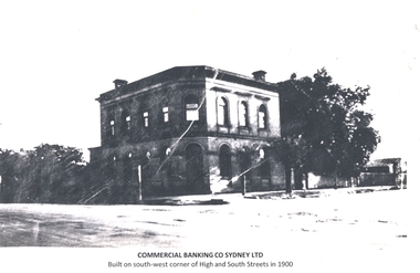
Photograph - Commercial Bank of Sydney, High Street, Wodonga, 1876 - 2025
... The new building was constructed with innovative foundations designed to prevent damage from vibrations caused by heavy transport vehicles along High Street which was then part of the Hume Highway. A contemporary newspaper article provides detail of the new bank. ...The new building was constructed with innovative foundations designed to prevent damage from vibrations caused by heavy transport vehicles along High Street which was then part of the Hume Highway. A contemporary newspaper article provides detail of the new bank. ...The Bank of Victoria was established in Wodonga during 1873. This two storey bank was constructed on the site in 1876. It later became the Commercial Banking Company of Sydney. In 1876 the Albury Banner and Wodonga Express reported that Mr. Nation had gained the contract for the erection of a new building for the Bank of Victoria, at Wodonga. The site secured for the bank was at the corner of South and Sydney streets, and immediately opposite the new Post and Telegraph Offices. The original bank was demolished in the 1950s and a new bank was built on the site. The new building was constructed with innovative foundations designed to prevent damage from vibrations caused by heavy transport vehicles along High Street which was then part of the Hume Highway. A contemporary newspaper article provides detail of the new bank. The well-lit building with open banking offices was designed by Melbourne architects, Turner and Stephenson, and combined a bright and attractive appearance with a stream-lined working layout. Alderson Swythyn Blackett-Smith, the manager of bank at time of move to new premises stated that the growth of the district and the bank’s business had made the old premises unsatisfactory due to insufficient space. The Commercial Banking Company of Sydney (CBC) merged with the National Bank of Australasia in 1982 to form the National Australia Bank and the second bank was closed. The building has since operated as several retail (including video hire and framing shop), commercial and community functions. It is currently (2025) used by the Wodonga Indie School.These images are significant because they document the development of an important financial institution established in Wodonga in the late 19th century.A series of images showing the evolution of the Commercial Banking Company of Sydney building in Wodonga from its construction in 1876 to the development of the site in 2025.commercial banking company of sydney, banking wodonga, wodonga financial institutions -
 Wodonga & District Historical Society Inc
Memorabilia - Melbourne Olympic Torch Bearer's Memento, Organising Committee for the XVIth Olympiad Melbourne, 1956
... He ran his mile of the relay about six miles south of Wodonga on the Hume Highway at 3.00 am on Wednesday 21st November 1956. ...He ran his mile of the relay about six miles south of Wodonga on the Hume Highway at 3.00 am on Wednesday 21st November 1956. ...This torch was donated to the Wodonga & District Historical Society by John Flower. John was a torch bearer in the Torch Relay for the Melbourne Olympic Games of 1956. In order to be selected for the Torch Relay the participants had to be able to run 1 mile (1.61 km) in 7.5 minutes. John was a talented distance runner, winning many distance events in the Wodonga area. He ran his mile of the relay about six miles south of Wodonga on the Hume Highway at 3.00 am on Wednesday 21st November 1956. The relay spanned approximately 20,470 km (including air travel) and involved 3,181 torchbearers across Greece and Australia. The actual Olympic torch left Olympia in Greece on 2nd November 1956 with the first torchbearer being Dionyssios Papathanassopoulos. The relay then covered approximately 20,470 kilometres including air travel and involved 3,181 torchbearers across Greece and Australia. The flame travelled by air to Australia, with stopovers along the way in Istanbul, Basra, Karachi, Calcutta, Bangkok, Singapore, Jakarta arriving in Darwin on 6thNovember 1956. The flame was the transported by Royal Australian Air Force jet bomber to Cairns. The first Australian Torchbearer was Con Verevis, of Greek-born parents, followed by indigenous athlete Anthony Mark. It was carried by 3,181 torchbearer before the Olympic Flame in Melbourne was lit by a 19-year-old middle-distance runner, who lit the cauldron at the Melbourne Cricket Ground on 22nd November 1956.This item is significant because it donated by a Wodonga resident who participated in the Melbourne Olympics Torch Relay near Wodonga.A small replica torch given to participants in the torch relay for the Melbourne Olympic Games of 1956melbourne olympics, john flower wodonga, melbourne olympics torch relay -
 Wodonga & District Historical Society Inc
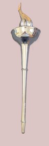
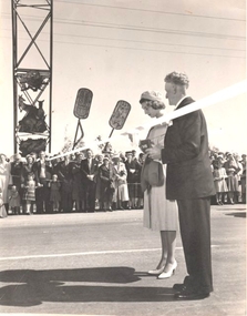
Functional object - Scissors - Princess Alexandra opens Pollard Archway, Wodonga
... Princess Alexandra led by a pipe band was driven along the Hume Highway and High Street which were lined by thousands of people including school children. ...Princess Alexandra led by a pipe band was driven along the Hume Highway and High Street which were lined by thousands of people including school children. ...In 1959 Princess Alexandra of Kent visited Australia as the representative of Queen Elizabeth II for the Queensland Centenary Celebrations. Her six week visit began with her arrival in Canberra on 14th August 14 and she departed from Canberra on 26th September. Time spent in Australia included 3 weeks in Queensland. Her Royal Highness' visits to New South Wales and Victoria were comparatively brief and informal. In New South Wales she made two country visits including to Albury and a night spent at Bungowannah Park near Jindera. Her visit to Victoria began in Wodonga where she officially opened the Pollard Archway over the Causeway. She received an enthusiastic welcome as she approached the Archway accompanied by a motorcycle escort. As Princess Alexander stepped forward to take the scissors from a red plush case, her Lady-in- Waiting, Lady Moyra Hamilton, tugged at the Princess' sleeve, whispered and gave her a coin. The Princess handed the coin a halfpenny to the Wodonga Shire President, Cr J. S. Hore, saying: "I must give you this, otherwise it might be unlucky." (The halfpenny "gift" stems from an old English superstition that a "sharp" gift such as a knife or scissors must be dulled with copper or else a friendship will be lost. After cutting the ribbon and declaring the Pollard Arch, named in honour of Councillor Charles Pollard M.B.E. she was presented with a bouquet by 10-year old Leslie McLeod. Princess Alexandra led by a pipe band was driven along the Hume Highway and High Street which were lined by thousands of people including school children. After a short trip along High Street and Elgin Street to the Railway Station she departed from protocol to speak to the many children who had crossed the barricade. Princess Alexandra then boarded the Royal Train for her journey to Melbourne.This item is significant because it represents the visit to Wodonga of Princess Alexandra in 1959.A pair of scissors in a red box. The bottom of the box is lined with red cloth and the lid is lined with white silk bearing the trademark "Jewelcrest". The scissors are engraved with the maker's mark for GIESEN & FORSTHOFF/ SOLINGEN GERMANYOn top of Box. The Official Opening by Her Royal Highness Princess Alexandra of Kent 0f the Cr C F Pollard MBE Archway Wodonga 16th Sept 1959 On Scissors: GIESEN & FORSTHOFF/ SOLINGEN GERMANY TIMOR SOLINGENprincess alexandra, pollard arch -
 Wodonga & District Historical Society Inc
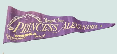
Memorabilia - Flag - Princess Alexandra's visit to Wodonga, 1959
... Princess Alexandra, led by a pipe band was driven along the Hume Highway and High Street which were lined by thousands of people including school children. ...Princess Alexandra, led by a pipe band was driven along the Hume Highway and High Street which were lined by thousands of people including school children. ...This flag is a memento produced for Princess Alexandra of Kent's visit to Wodonga in 1959. Princess Alexandra visited Australia as the representative of Queen Elizabeth II for the Queensland Centenary Celebrations. Her six-week visit began with her arrival in Canberra on 14th August and she departed from Canberra on 26th September. Time spent in Australia included three weeks in Queensland. Her Royal Highness' visits to New South Wales and Victoria were comparatively brief and informal. In New South Wales she made two country visits including to Albury and a night spent at Bungowannah Park near Jindera. Her visit to Victoria began in Wodonga where she officially opened the Pollard Archway over the Causeway. She received an enthusiastic welcome as she approached the Archway accompanied by a motorcycle escort. As Princess Alexander stepped forward to take the scissors from a red plush case, her Lady-in-Waiting, Lady Moyra Hamilton, tugged at the Princess' sleeve, whispered, and gave her a coin. The Princess handed the coin (a halfpenny) to the Wodonga Shire President, Cr J. S. Hore, saying: "I must give you this, otherwise it might be unlucky." The halfpenny "gift" stems from an old English superstition that a "sharp" gift such as a knife or scissors must be dulled with copper or else a friendship will be lost. After cutting the ribbon and declaring the Pollard Arch, named in honour of Councillor Charles Pollard M.B.E., she was presented with a bouquet by 10-year-old Leslie McLeod. Princess Alexandra, led by a pipe band was driven along the Hume Highway and High Street which were lined by thousands of people including school children. After a short trip along High Street and Elgin Street to the Railway Station she departed from protocol to speak to the many children who had crossed the barricade. Princess Alexandra then boarded the Royal Train for her journey to Melbourne.This item is significant because it represents the visit to Wodonga of Princess Alexandra in 1959.A small purple flag with gold lettering and a symbol of the Pollard Arch in Wodonga. It is triangular in shape and attached to a thin wooden stick.Royal Tour Princess Alexandra Wodonga September 1959princess alexandra, royal visit 1959 wodonga -
 Wodonga & District Historical Society Inc
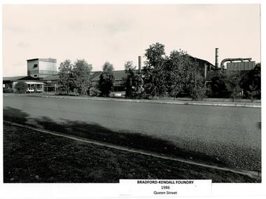
Photograph - Bradford Kendall, Wodonga
... Wodonga was ideally placed as a change point between the different rail gauges of Victoria and New South Wales, close to the Hume Highway and the Snowy Mountain Scheme. The first sod for the site was turned on 2nd June 1954 and the first melt and pour of molten metal at Wodonga took place on 7th July 1954. ...Wodonga was ideally placed as a change point between the different rail gauges of Victoria and New South Wales, close to the Hume Highway and the Snowy Mountain Scheme. The first sod for the site was turned on 2nd June 1954 and the first melt and pour of molten metal at Wodonga took place on 7th July 1954. ...Bradford Kendall was established in 1922 by Lesley Bradford and Jim Kendall, investing their winnings on a race horse. They both previously worked at the BHP Steel Works. They gained contracts with the railways and mining industry. During World War II they also manufactured armaments. During the boom of the 1950s they established several foundries in South Australia, Western Australia, Queensland and Victoria. Bradford Kendall Ltd Wodonga foundry was established in 1954. It melted down old railway wheels, rails and redundant machinery to produce a range of low-alloy steel products, especially for earth-moving vehicles, railways, oil rigs and sugar factories. Wodonga was ideally placed as a change point between the different rail gauges of Victoria and New South Wales, close to the Hume Highway and the Snowy Mountain Scheme. The first sod for the site was turned on 2nd June 1954 and the first melt and pour of molten metal at Wodonga took place on 7th July 1954. Bradford Kendall Plant No.5 in Wodonga became one of the most profitable foundries in the Bradford Kendall group. Bill Black became the first plant Manager, a position he held for 30 years. Another long term employee was Pat Gooding who began work at a 15 year old and retired for the position of Bradken foundry Manufacturing Manager 51 years later. In the early 1980s, Australian National Industries Ltd bought Bradford Kendall and other heavy engineering companies. The Wodonga foundry with its (then) 170 or so staff became part of Bradken Consolidated along with nine other foundries in Australia and New Zealand. In 1989, Kerry Packer’s Consolidated Press Holdings Ltd took control of ANI. In January 1999, Smorgon Steel Group acquired ANI, which included the Bradken business. The company changed hands again in 2001 when Smorgon Steel Group sold Bradken to Castle Harlan Australian Mezzanine Partners (CHAMP). In 2016 negotiations began for Bradken to be taken over by Hitachi Construction for A$689 million. In April 2017 Bradken became a wholly owned subsidiary of Hitachi Construction Machinery Co. Limited.A collection of black and white images and advertising for Bradford Kendall (Bradken) Wodonga.bradford kendall, wodonga industries, wodonga businesses -
 Eltham District Historical Society Inc
Photograph, Hume and Hovell passed here at Seymour 28 Oct 1824, Spring Excursion, Hume and Hovell's 1824 expedition (Part 2), 26 October 1997, 26/10/1997
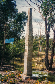
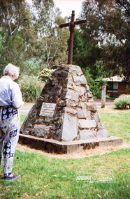
... We headed towards the Hume Highway via Greensborough and Cooper Street and proceeded north to our first stop, noting on the way Monument Hill in the distance which is near Kilmore and, according to Russell, well worth the effort to visit as the view across the valley is magnificent. ...We headed towards the Hume Highway via Greensborough and Cooper Street and proceeded north to our first stop, noting on the way Monument Hill in the distance which is near Kilmore and, according to Russell, well worth the effort to visit as the view across the valley is magnificent. ...[article by Diana Bassett-Smith in EDHS Newsletter No. 117, November 1997:] MONUMENT HUNTING THE HUME AND HOVELL WAY - Sunday October 26 1997 dawned bright and very warm. Some twenty-five members, complete with picnic baskets, met outside the Eltham Library awaiting the Cobb and Co. large coach which would be taking us on the second leg of our travels along the route of the early explorers Hume and Hovell. Stephen West was our very good driver for the day. He would be guided around the circuitous route by Russell Yeoman who had made a detailed study, not only of the intended route, but of the story of these two explorers. During the trip Russell regaled us with poetry, quotations from the Journals and the History of the Shire of Seymour, "The New Crossing Place" by Martindale, 1982, (now Mitchell Shire due to the recent amalgamations). We headed towards the Hume Highway via Greensborough and Cooper Street and proceeded north to our first stop, noting on the way Monument Hill in the distance which is near Kilmore and, according to Russell, well worth the effort to visit as the view across the valley is magnificent. Past Sunday Creek Valley, Mt Piper and Mt Disappointment, all traversed and noted and named by them. We passed through Tallarook, then onto Seymour where we took photos of the monument telling us that Hume and Hovell had passed through on the 28th of October 1824. We also deviated down Hume and Hovell Road viewing deer and emu farming and the Bellbourie property now a sanctuary. Leaving Seymour behind we travelled up the Avenel Road to the Avenel monument, pyramidal in design of four reducing square blocks with a sharply pointed peak, erected in 1924 in memory of the 1824 exploration. The day was warming up and the countryside showing the dryness of the current drought. A parallel note had been made in their journal too of 1824 of the drought appearance of the country they were traversing. At Seven Creeks, Euroa we stopped for some minutes to check the monument placed 20th November 1924 to commemorate their passage on the 29th December 1824. More photos. Russell had pointed out the abrupt termination of the distant ranges which is noted in their journal. The next monument is beside the road at the entrance to Honey Suckle Creek Caravan Park, Violet Town. The squarish shaped monument some eight feet high is topped with a simple steel cross, and was to mark the date of 28th December 1824 and built for the 20th November 1924. By now it was 12.20 and nearly lunchtime as we drove along the Warranbayne Road to Roach's Road, monument hunting without success. Though there is a large, what appears to be an old timber sign which was hard to read, maybe this was the lost monument. In many of the paddocks hay had been cut and baled or was being cut, what a contrast to the rugged country they had passed through which was smoky from the fires of the natives burning off. By 1.00 pm we were at Benalla and pulled up beside the park where abundant beds of roses filled the air with their scent and the smell of barbecued food twitched the nostrils whilst the cheerful sounds of other picnickers could be heard throughout the park. We left the bus and collected up our picnics, dispersed to the various tables and enjoyed the shade from the various European trees. 2.00 pm and we were on the road again driving along the Benalla, Mansfield, Yea road. The Swanpool monument states that they passed four miles south and returned three miles north. Then we stopped at the Barjarg monument which notes that they camped near this spot. It is again a pyramidal monument and this time topped with a steel arrow indicating their route of the 29th November 1824. Half an hour later we came to another monument, again with a steel arrow marker on top and the plaque dated the 2nd of 12th 1824. Erected on the 12th of 12th 1924. "They blazed the way that we might inherit the land." Another square based and needle topped monument appeared at Yarck near Yea and this plaque records the date of 3 December 1824. Near McGuigans Road Russell related that the expedition had lost a dog but it had found them next day, the dog was apparently torn by a kangaroo. A short while later Russell reminded us here of the problems they encountered in crossing the Goulburn River near Molesworth where banks were high, water deep and wide. "Good coat of grass but quite dry due to drought". At Yea we stopped for afternoon tea and raided the last of our picnics and looked at the monument to their journey of 1824, situated at a corner of the gardens near the bowling green. No photo – we were out of film. We returned home via Kinglake West and Whittlesea past the Yan Yean Reservoir, not full. 5.00 pm back at Eltham we emptied out of the bus and everyone, including Joan Cole, collected their things, Joan also had the major souvenir of the day, a large carp she had picked up from the river bank, her cat was in for a great feast. The day was made so interesting by the informed commentary which Russell provided. His background knowledge of the route and nature of the journey could only have come from many hours of reading and driving the area. Thank you to Russell and to everyone who made the day so informative and pleasurable. Colour photographactivities, hume and hovell, monument, seymour -
 Eltham District Historical Society Inc
Photograph, Spring Excursion, Hume and Hovell's 1824 expedition (Part 2), 26 October 1997, 26/10/1997
... We headed towards the Hume Highway via Greensborough and Cooper Street and proceeded north to our first stop, noting on the way Monument Hill in the distance which is near Kilmore and, according to Russell, well worth the effort to visit as the view across the valley is magnificent. ...We headed towards the Hume Highway via Greensborough and Cooper Street and proceeded north to our first stop, noting on the way Monument Hill in the distance which is near Kilmore and, according to Russell, well worth the effort to visit as the view across the valley is magnificent. ...[article by Diana Bassett-Smith in EDHS Newsletter No. 117, November 1997:] MONUMENT HUNTING THE HUME AND HOVELL WAY - Sunday October 26 1997 dawned bright and very warm. Some twenty-five members, complete with picnic baskets, met outside the Eltham Library awaiting the Cobb and Co. large coach which would be taking us on the second leg of our travels along the route of the early explorers Hume and Hovell. Stephen West was our very good driver for the day. He would be guided around the circuitous route by Russell Yeoman who had made a detailed study, not only of the intended route, but of the story of these two explorers. During the trip Russell regaled us with poetry, quotations from the Journals and the History of the Shire of Seymour, "The New Crossing Place" by Martindale, 1982, (now Mitchell Shire due to the recent amalgamations). We headed towards the Hume Highway via Greensborough and Cooper Street and proceeded north to our first stop, noting on the way Monument Hill in the distance which is near Kilmore and, according to Russell, well worth the effort to visit as the view across the valley is magnificent. Past Sunday Creek Valley, Mt Piper and Mt Disappointment, all traversed and noted and named by them. We passed through Tallarook, then onto Seymour where we took photos of the monument telling us that Hume and Hovell had passed through on the 28th of October 1824. We also deviated down Hume and Hovell Road viewing deer and emu farming and the Bellbourie property now a sanctuary. Leaving Seymour behind we travelled up the Avenel Road to the Avenel monument, pyramidal in design of four reducing square blocks with a sharply pointed peak, erected in 1924 in memory of the 1824 exploration. The day was warming up and the countryside showing the dryness of the current drought. A parallel note had been made in their journal too of 1824 of the drought appearance of the country they were traversing. At Seven Creeks, Euroa we stopped for some minutes to check the monument placed 20th November 1924 to commemorate their passage on the 29th December 1824. More photos. Russell had pointed out the abrupt termination of the distant ranges which is noted in their journal. The next monument is beside the road at the entrance to Honey Suckle Creek Caravan Park, Violet Town. The squarish shaped monument some eight feet high is topped with a simple steel cross, and was to mark the date of 28th December 1824 and built for the 20th November 1924. By now it was 12.20 and nearly lunchtime as we drove along the Warranbayne Road to Roach's Road, monument hunting without success. Though there is a large, what appears to be an old timber sign which was hard to read, maybe this was the lost monument. In many of the paddocks hay had been cut and baled or was being cut, what a contrast to the rugged country they had passed through which was smoky from the fires of the natives burning off. By 1.00 pm we were at Benalla and pulled up beside the park where abundant beds of roses filled the air with their scent and the smell of barbecued food twitched the nostrils whilst the cheerful sounds of other picnickers could be heard throughout the park. We left the bus and collected up our picnics, dispersed to the various tables and enjoyed the shade from the various European trees. 2.00 pm and we were on the road again driving along the Benalla, Mansfield, Yea road. The Swanpool monument states that they passed four miles south and returned three miles north. Then we stopped at the Barjarg monument which notes that they camped near this spot. It is again a pyramidal monument and this time topped with a steel arrow indicating their route of the 29th November 1824. Half an hour later we came to another monument, again with a steel arrow marker on top and the plaque dated the 2nd of 12th 1824. Erected on the 12th of 12th 1924. "They blazed the way that we might inherit the land." Another square based and needle topped monument appeared at Yarck near Yea and this plaque records the date of 3 December 1824. Near McGuigans Road Russell related that the expedition had lost a dog but it had found them next day, the dog was apparently torn by a kangaroo. A short while later Russell reminded us here of the problems they encountered in crossing the Goulburn River near Molesworth where banks were high, water deep and wide. "Good coat of grass but quite dry due to drought". At Yea we stopped for afternoon tea and raided the last of our picnics and looked at the monument to their journey of 1824, situated at a corner of the gardens near the bowling green. No photo – we were out of film. We returned home via Kinglake West and Whittlesea past the Yan Yean Reservoir, not full. 5.00 pm back at Eltham we emptied out of the bus and everyone, including Joan Cole, collected their things, Joan also had the major souvenir of the day, a large carp she had picked up from the river bank, her cat was in for a great feast. The day was made so interesting by the informed commentary which Russell provided. His background knowledge of the route and nature of the journey could only have come from many hours of reading and driving the area. Thank you to Russell and to everyone who made the day so informative and pleasurable. Colour photographactivities, hume and hovell, bridge -
 Eltham District Historical Society Inc
Photograph, Spring Excursion, Hume and Hovell bus tour Stage 2, Seymour, Benalla; 26 Oct 1997, 26/10/1997
... We headed towards the Hume Highway via Greensborough and Cooper Street and proceeded north to our first stop, noting on the way Monument Hill in the distance which is near Kilmore and, according to Russell, well worth the effort to visit as the view across the valley is magnificent. ...We headed towards the Hume Highway via Greensborough and Cooper Street and proceeded north to our first stop, noting on the way Monument Hill in the distance which is near Kilmore and, according to Russell, well worth the effort to visit as the view across the valley is magnificent. ...MONUMENT HUNTING THE HUME AND HOVELL WAY (Newsletter No. 117, November 1997, by Diana Bassett-Smith) Sunday October 26 1997 dawned bright and very warm. Some twenty-five members, complete with picnic baskets, met outside the Eltham Library awaiting the Cobb and Co. large coach which would be taking us on the second leg of our travels along the route of the early explorers Hume and Hovell. Stephen West was our very good driver for the day. He would be guided around the circuitous route by Russell Yeoman wh9 had made a detailed study, not only of the intended route, but of the story of these two explorers. During the trip Russell regaled us with poetry, quotations from the Journals and the History of the Shire of Seymour, "The New Crossing Place: by Martindale, 1982, (now Mitchell Shire due to the recent amalgamations). We headed towards the Hume Highway via Greensborough and Cooper Street and proceeded north to our first stop, noting on the way Monument Hill in the distance which is near Kilmore and, according to Russell, well worth the effort to visit as the view across the valley is magnificent. Past Sunday Creek Valley, Mt Piper and Mt Disappointment, all traversed and noted and named by them. We passed through Tallarook, then onto Seymour where we took photos of the monument telling us that Hume and Hovell had passed through on the 28th of October 1824. We also deviated down Hume and Hovell Road viewing deer and emu farming and the Bellbourie property now a sanctuary. Leaving Seymour behind we travelled up the Avenel Road to the Avenel monument, pyramidal in design of four reducing square blocks with a sharply pointed peak, erected in 1924 in memory of the 1824 exploration. The day was warming up and the countryside showing the dryness of the current drought. A parallel note had been made in their journal too of 1824 of the drought appearance of the country they were traversing. At Seven Creeks, Euroa we stopped for some minutes to check the monument placed 20th November 1924 to commemorate their passage on the 29th December 1824. More photos. Russell had pointed out the abrupt termination of the distant ranges which is noted in their journal. The next monument is beside the road at the entrance to Honey Suckle Creek Caravan Park, Violet Town. The squarish shaped monument some eight feet high is topped with a simple steel cross, and was to mark the date of 28th December 1824 and built for the 20th November 1924. By now it was 12.20 and nearly lunchtime as we drove along the Warranbayne Road to Roach's Road, monument hunting without success. Though there is a large, what appears to be an old timber sign which was hard to read, maybe this was the lost monument. In many of the paddocks hay had been cut and baled or was being cut, what a contrast to the rugged country they had passed through which was smoky from the fires of the natives burning off By 1.00 pm we were at Benalla and pulled up beside the park where abundant beds of roses filled the air with their scent and the smell of barbecued food twitched the nostrils whilst the cheerful sounds of other picnickers could be heard throughout the park. We left the bus and collected up our picnics, dispersed to the various tables and enjoyed the shade from the various European trees. 2.00 pm and we were on the road again driving along the Benalla, Mansfield, Yea road. The Swanpool monument states that they passed four miles south and returned three miles north. Then we stopped at the Barjarg monument which notes that they camped near this spot. It is again a pyramidal monument and this time topped with a steel arrow indicating their route of the 29th November 1824. Half an hour later we came to another monument, again with a steel arrow marker on top and the plaque dated the 2nd of 12th 1824. Erected on the 12th of 12th 1924. "They blazed the way that we might inherit the land." Another square based and needle topped monument appeared at Yarck near Yea and this plaque records the date of 3 December 1824. Near McGuigans Road Russell related that the expedition had lost a dog but it had found them next day, the dog was apparently torn by a kangaroo. A short while later Russell reminded us here of the problems they encountered in crossing the Goulburn River near Molesworth where banks were high, water deep and wide. "Good coat of grass but quite dry due to drought". At Yea we stopped for afternoon tea and raided the last of our picnics and looked at the monument to their journey of 1824, situated at a corner of the gardens near the bowling green. No photo – we were out of film. We returned home via Kinglake West and Whittlesea past the Yan Yean Reservoir, not full. 5.00 pm back at Eltham we emptied out of the bus and everyone, including Joan Cole, collected their things, Joan also had the major souvenir of the day, a large carp she had picked up from the river bank, her cat was in for a great feast. The day was made so interesting by the informed commentary which Russell provided. His background knowledge of the route and nature of the journey could only have come from many hours of reading and driving the area. Thank you to Russell and to everyone who made the day so informative and pleasurable. Diana Bassett-Smith. Record of the Society's history of activities - Spring 1997 excursionRoll of 35mm colour negative film, 6 stripsFuji 200shire of eltham historical society, activities, pretty hill, seymour, benalla, hume and hovell, monuments -
 Eltham District Historical Society Inc
Photograph, Spring Excursion, Hume and Hovell bus tour Stage 2, Seymour, Benalla; 26 Oct 1997, 26/10/1997
... We headed towards the Hume Highway via Greensborough and Cooper Street and proceeded north to our first stop, noting on the way Monument Hill in the distance which is near Kilmore and, according to Russell, well worth the effort to visit as the view across the valley is magnificent. ...We headed towards the Hume Highway via Greensborough and Cooper Street and proceeded north to our first stop, noting on the way Monument Hill in the distance which is near Kilmore and, according to Russell, well worth the effort to visit as the view across the valley is magnificent. ...MONUMENT HUNTING THE HUME AND HOVELL WAY (Newsletter No. 117, November 1997, by Diana Bassett-Smith) Sunday October 26 1997 dawned bright and very warm. Some twenty-five members, complete with picnic baskets, met outside the Eltham Library awaiting the Cobb and Co. large coach which would be taking us on the second leg of our travels along the route of the early explorers Hume and Hovell. Stephen West was our very good driver for the day. He would be guided around the circuitous route by Russell Yeoman wh9 had made a detailed study, not only of the intended route, but of the story of these two explorers. During the trip Russell regaled us with poetry, quotations from the Journals and the History of the Shire of Seymour, "The New Crossing Place: by Martindale, 1982, (now Mitchell Shire due to the recent amalgamations). We headed towards the Hume Highway via Greensborough and Cooper Street and proceeded north to our first stop, noting on the way Monument Hill in the distance which is near Kilmore and, according to Russell, well worth the effort to visit as the view across the valley is magnificent. Past Sunday Creek Valley, Mt Piper and Mt Disappointment, all traversed and noted and named by them. We passed through Tallarook, then onto Seymour where we took photos of the monument telling us that Hume and Hovell had passed through on the 28th of October 1824. We also deviated down Hume and Hovell Road viewing deer and emu farming and the Bellbourie property now a sanctuary. Leaving Seymour behind we travelled up the Avenel Road to the Avenel monument, pyramidal in design of four reducing square blocks with a sharply pointed peak, erected in 1924 in memory of the 1824 exploration. The day was warming up and the countryside showing the dryness of the current drought. A parallel note had been made in their journal too of 1824 of the drought appearance of the country they were traversing. At Seven Creeks, Euroa we stopped for some minutes to check the monument placed 20th November 1924 to commemorate their passage on the 29th December 1824. More photos. Russell had pointed out the abrupt termination of the distant ranges which is noted in their journal. The next monument is beside the road at the entrance to Honey Suckle Creek Caravan Park, Violet Town. The squarish shaped monument some eight feet high is topped with a simple steel cross, and was to mark the date of 28th December 1824 and built for the 20th November 1924. By now it was 12.20 and nearly lunchtime as we drove along the Warranbayne Road to Roach's Road, monument hunting without success. Though there is a large, what appears to be an old timber sign which was hard to read, maybe this was the lost monument. In many of the paddocks hay had been cut and baled or was being cut, what a contrast to the rugged country they had passed through which was smoky from the fires of the natives burning off By 1.00 pm we were at Benalla and pulled up beside the park where abundant beds of roses filled the air with their scent and the smell of barbecued food twitched the nostrils whilst the cheerful sounds of other picnickers could be heard throughout the park. We left the bus and collected up our picnics, dispersed to the various tables and enjoyed the shade from the various European trees. 2.00 pm and we were on the road again driving along the Benalla, Mansfield, Yea road. The Swanpool monument states that they passed four miles south and returned three miles north. Then we stopped at the Barjarg monument which notes that they camped near this spot. It is again a pyramidal monument and this time topped with a steel arrow indicating their route of the 29th November 1824. Half an hour later we came to another monument, again with a steel arrow marker on top and the plaque dated the 2nd of 12th 1824. Erected on the 12th of 12th 1924. "They blazed the way that we might inherit the land." Another square based and needle topped monument appeared at Yarck near Yea and this plaque records the date of 3 December 1824. Near McGuigans Road Russell related that the expedition had lost a dog but it had found them next day, the dog was apparently torn by a kangaroo. A short while later Russell reminded us here of the problems they encountered in crossing the Goulburn River near Molesworth where banks were high, water deep and wide. "Good coat of grass but quite dry due to drought". At Yea we stopped for afternoon tea and raided the last of our picnics and looked at the monument to their journey of 1824, situated at a corner of the gardens near the bowling green. No photo – we were out of film. We returned home via Kinglake West and Whittlesea past the Yan Yean Reservoir, not full. 5.00 pm back at Eltham we emptied out of the bus and everyone, including Joan Cole, collected their things, Joan also had the major souvenir of the day, a large carp she had picked up from the river bank, her cat was in for a great feast. The day was made so interesting by the informed commentary which Russell provided. His background knowledge of the route and nature of the journey could only have come from many hours of reading and driving the area. Thank you to Russell and to everyone who made the day so informative and pleasurable. Diana Bassett-Smith. Record of the Society's history of activities - Spring 1997 excursionRoll of 35mm colour negative film, 2 stripsKodak Gold 400-5shire of eltham historical society, activities, pretty hill, seymour, benalla, hume and hovell, monuments