Showing 580 items matching " kilometres"
-
 Melbourne Tram Museum
Document, The Met, "Kilometres Operated by each depot", 6/1989
... "Kilometres Operated by each depot"...Report dated 26/6/1989 provides details on the kilometres operated by each depot on various days, by each route, average headways, route lengths, route statistical information, and tram fleet allocation by type and depot....Twelve page report dated 26/6/1989 titled "Kilometres Operated by each depot"...Yields information about The Met tram operational statistics for 1989. tramways routes statistics fleet depots operations Twelve page report dated 26/6/1989 titled "Kilometres Operated by each depot" "Kilometres Operated by each depot" Document The Met ...Report dated 26/6/1989 provides details on the kilometres operated by each depot on various days, by each route, average headways, route lengths, route statistical information, and tram fleet allocation by type and depot.Yields information about The Met tram operational statistics for 1989.Twelve page report dated 26/6/1989 titled "Kilometres Operated by each depot"tramways, routes, statistics, fleet, depots, operations -
 Melbourne Tram Museum
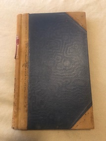
Document - Notebook, Melbourne & Metropolitan Tramways Board (MMTB), "Tram / Bus Kilometres", c1965
... "Tram / Bus Kilometres"...... Kilometres...Each book has been ruled in red ink, headed year and month, days, page totals with data entered for each depot of the distance or mileage or kilometres for each date, including separate tram and bus entries. .1 - Blue cloth covered with Letraset, black plastic strip on outside "Tram / Bus Kilometres" for the period 1-7-1965 to 30-6-1975. ...Burrows. "Tram / Bus Kilometres" Document Notebook Melbourne & Metropolitan Tramways Board (MMTB) W. ...Set of two notebook or lined journals, with light brown pig skin binding strips and in each of the corners binding, faint ruled Collins 4393 books with red labels on the outside binding, sewn sections, printed glued inside covers. Each book has been ruled in red ink, headed year and month, days, page totals with data entered for each depot of the distance or mileage or kilometres for each date, including separate tram and bus entries. .1 - Blue cloth covered with Letraset, black plastic strip on outside "Tram / Bus Kilometres" for the period 1-7-1965 to 30-6-1975. Notes change over to Kms from miles on 1/7/1974. Has head office contact details on the first page. .2 - Red cloth cover with Letraset black plastic strip on outside "Kilometres" drawn up for the period - 1-7-1975 to 13-11-1985, though drawn up to Jan. 1985. Has head office contact details on the first page. Has a note on the last used page about the instruction to discontinue the book on 13/11/1985 from Mr. W. Burrows.trams, tramways, tramcars, mileages, kilometres, buses, depots, distances -
 Melbourne Tram Museum
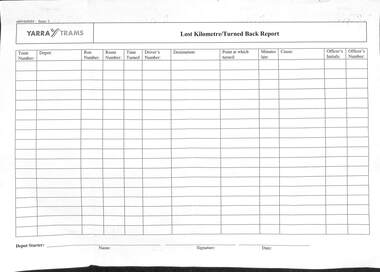
Document - Form/s, Yarra Trams, "Operations Officer's Report of car turned back and kilometres lost for..", "Lost Kilometre/Turned Back Report", c2005?
... "Operations Officer's Report of car turned back and kilometres lost for..", "Lost Kilometre/Turned Back Report"...Set of two forms - A4 photocopies - Yarra Trams .1 - "Operations Officer's Report of car turned back and kilometres lost for.." .2 - "Lost Kilometre/Turned Back Report" To provide details of tram services that were turned back or "short shunted" and details - recording the tram, depot, run number, route, time, driver's details, destination, point of turn back, minutes late, cause, and Officer's details. ..."Operations Officer's Report of car turned back and kilometres lost for..", "Lost Kilometre/Turned Back Report" Document Form/s Yarra Trams ...Set of two forms - A4 photocopies - Yarra Trams .1 - "Operations Officer's Report of car turned back and kilometres lost for.." .2 - "Lost Kilometre/Turned Back Report" To provide details of tram services that were turned back or "short shunted" and details - recording the tram, depot, run number, route, time, driver's details, destination, point of turn back, minutes late, cause, and Officer's details. This information became important for the performance reports to Government.trams, tramways, tramcars, operations, forms, depots, yarra trams -
 Melbourne Tram Museum
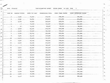
Document - Report, Melbourne & Metropolitan Tramways Board (MMTB), "Tram Kilometres Report Period Ended 4/4/1981", 8/04/1981 12:00:00 AM
... "Tram Kilometres Report Period Ended 4/4/1981"...List by class, depot, brake kilometres, truck kms. Does not appear to list L class, works cars. ...List by class, depot, brake kilometres, truck kms. Does not appear to list L class, works cars. ...Report - photocopy of a computer print out, 36 pages, stapled in top left hand corner, titled "Tram Kilometres Report Period Ended 4/4/1981", dated 8/4/1981 listing Tram No., Current Period, Since 1st July, Progressive Total, Since Truck Change, Since Compressor Change, for all trams. List by class, depot, brake kilometres, truck kms. Does not appear to list L class, works cars. Has some updates in ink. Only front page imaged.Updates in ink - date unknown.trams, tramways, tramcars, mmtb, lists, depots, depot allocation, bogies, mileages -
 Melbourne Tram Museum
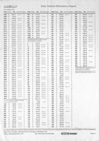
Document - Report, Yarra Trams, "Daily Vehicle Kilometres Report", 2010
... "Daily Vehicle Kilometres Report"...Report - by Yarra Trams- "Daily Vehicle Kilometres Report" - provides the distance travelled for each tram in service on 9 Dec. 2010...."Daily Vehicle Kilometres Report" Document Report Yarra Trams ...Report - by Yarra Trams- "Daily Vehicle Kilometres Report" - provides the distance travelled for each tram in service on 9 Dec. 2010.Yields information about the distance travelled by each tram on a particular date.Report - photocopied - A4 double sided sheet.In pencil on top edge "This only shows trams that ran services or transport.tramways, trams, forms, reports, yarra trams, distance -
Phillip Island and District Historical Society Inc.
Postcard
... Road to the Back Beach, about 1.5 kilometres from Cowes...Phillip Island and District Historical Society Inc. phillip-island-and-the-bass-coast This Postcard came from the Estate of Keith McIlwraith on 20th July, 1983 Local History DOCUMENTS Postcards Early Postcards Postcard Beaches Phillip Island Road to the Back Beach, about 1.5 kilometres from Cowes Postcard ...This Postcard came from the Estate of Keith McIlwraith on 20th July, 1983Road to the Back Beach, about 1.5 kilometres from Coweslocal history, documents, postcards, early postcards, postcard, beaches, phillip island -
Ringwood and District Historical Society
Booklet, Scenic Walk Around Croydon Hills
... Walk of 3 kilometres around Croydon Hills with 16 points of interest...Ringwood and District Historical Society 125A Warrandyte Road Ringwood North melbourne Walk of 3 kilometres around Croydon Hills with 16 points of interest Scenic Walk Around Croydon Hills Booklet ...Walk of 3 kilometres around Croydon Hills with 16 points of interest -
 Lakes Entrance Historical Society
Photograph, 1994 c
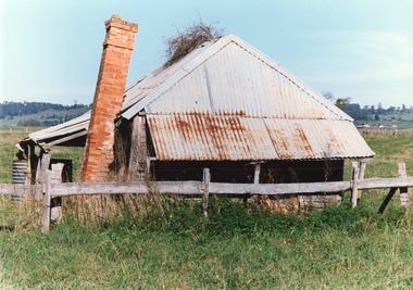
... Colour photograph of an iconic old building about a kilometre west of Bruthen, on the south side of the Bairnsdale / Bruthen Road, Victoria...Lakes Entrance Historical Society 4 Marine Parade Lakes Entrance gippsland Also second identical copy Buildings Local History Colour photograph of an iconic old building about a kilometre west of Bruthen, on the south side of the Bairnsdale / Bruthen Road, Victoria Photograph ...Also second identical copyColour photograph of an iconic old building about a kilometre west of Bruthen, on the south side of the Bairnsdale / Bruthen Road, Victoriabuildings, local history -
Ringwood and District Historical Society
Booklet, Maroondah City Council - Tourism Advisory Board, Scenic Walk Around Maroondah Lakes
... Details of 20 points of interest on 12 kilometre return trip from Croydon Lake and Library, including Ringwood Lake (circa 1990s)...Ringwood and District Historical Society 125A Warrandyte Road Ringwood North melbourne Details of 20 points of interest on 12 kilometre return trip from Croydon Lake and Library, including Ringwood Lake (circa 1990s) Scenic Walk Around Maroondah Lakes Booklet Maroondah City Council - Tourism Advisory Board ...Details of 20 points of interest on 12 kilometre return trip from Croydon Lake and Library, including Ringwood Lake (circa 1990s) -
 Sunshine and District Historical Society Incorporated
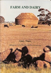
Book - Farm and Dairy. The Agricultural and Dairy Farms of Melbourne's West, Melbourne's Living Museum of the West, 1993
... The front cover illustrates dairy cattle grazing near a traditional haystack at Truganina, a few kilometres from Melbourne's western suburbs....The front cover illustrates dairy cattle grazing near a traditional haystack at Truganina, a few kilometres from Melbourne's western suburbs. Farm and Dairy. ...The book tells the story of the small farms and farmers of the rural districts on Melbourne's western fringe.Slim A 5 book, well-illustrated. The front cover illustrates dairy cattle grazing near a traditional haystack at Truganina, a few kilometres from Melbourne's western suburbs.non-fictionThe book tells the story of the small farms and farmers of the rural districts on Melbourne's western fringe.farming, dairy, vineyards -
 Wangaratta Historical Society
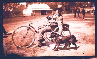
Three Wheeled Dog Cart, Three Wheeled Cart Pulled by Dog, Unknown
... Mr Ernie Fitzgerald of Tarrawingee, traveled to Wangaratta, a distance of 14 Kilometres on Market days for his provisions. ...An example of a glass plate negative is featured above of Mr Ernie Fitzgerald of Tarrawingee who traveled to Wangaratta, a distance of 14 Kilometres on Market days for his provisions. ...Wangaratta Historical Society 29 Ford Street Wangaratta high-country Mr Ernie Fitzgerald of Tarrawingee, traveled to Wangaratta, a distance of 14 Kilometres on Market days for his provisions. ...Mr Ernie Fitzgerald of Tarrawingee, traveled to Wangaratta, a distance of 14 Kilometres on Market days for his provisions. He was pulled along by his one of two dogs attached to a hand held leather strap (recounted by a witness who remembers Mr Fitzgerald's weekly visit to Wangaratta for supplies at The CoStore). This vehicle remains in possession of his family. This was an unique mode of transport in the 1930's, the witness was a child at the time and remembers Mr Fitzgerald and his dogs and the cart quite clearly. This is a unique mode of transport for the area, is documented and still in existence. WHS Inc were presented with 10,000 glass plate negative from Thelma & Vine Photographic Studios Murphy Street Wangaratta from the 1860's - 1950's. An example of a glass plate negative is featured above of Mr Ernie Fitzgerald of Tarrawingee who traveled to Wangaratta, a distance of 14 Kilometres on Market days for his provisions. He was pulled along by his one of two dogs attached to a hand held leather strap. (Recounted by a witness who remembers Mr Fitzgerald's weekly visit to Wangaratta for supplies). This vehicle remains in possession of his family. Unknownthree wheel steerable chair -
 Lakes Entrance Historical Society
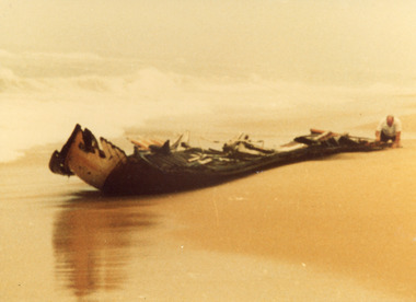
Photograph - Kieth Bryce, Bryce, Anne, 1981
... Colour photograph showing Keith Bryce inspecting the remains of the wrecked St John Star which became stranded in fog fourteen kilometres east of Lake Tyers, near Lakes Entrance, Victoria....Lakes Entrance Historical Society 4 Marine Parade Lakes Entrance gippsland Date made 13 August 1981 Fishing Industry Ships and Shipping Shipwrecks Colour photograph showing Keith Bryce inspecting the remains of the wrecked St John Star which became stranded in fog fourteen kilometres east of Lake Tyers, near Lakes Entrance, Victoria. ...Date made 13 August 1981Colour photograph showing Keith Bryce inspecting the remains of the wrecked St John Star which became stranded in fog fourteen kilometres east of Lake Tyers, near Lakes Entrance, Victoria.fishing industry, ships and shipping, shipwrecks -
 Bendigo Historical Society Inc.
Newspaper - Kangaroo Flat Gold Mine Collection: Perseverance Exploration Pty Ltd
... Axe Creek Landcare group opposed an application by Perseverance Exploration Pty Ltd for an 'exploration lease spanning 400 square kilometres on the eastern side of Bendigo'....Axe Creek Landcare group opposed an application by Perseverance Exploration Pty Ltd for an 'exploration lease spanning 400 square kilometres on the eastern side of Bendigo'. Newspaper Kangaroo Flat Gold Mine Collection: Perseverance Exploration Pty Ltd ...Newspaper article, July 2001, titled 'People reject mining'. Axe Creek Landcare group opposed an application by Perseverance Exploration Pty Ltd for an 'exploration lease spanning 400 square kilometres on the eastern side of Bendigo'.Written in blue pen on bottom of article 'B O'Day July 2001'gold mining, bendigo, exploration licence, perserverance exploration pty ltd., axe creek landcare group -
 Narre Warren and District Family History Group
Book, Heritage Branch Ministry for Planning and Environment, Architectural survey of the Berwick-Pakenham corridor : a report prepared by the Heritage Branch, Ministry for Planning and Environment, 1989
... The Corridor comprises an irregular area roughly 44 kilometres in length and varying in width from about 14 kilometres at the west end to 3 kilometres at the east. ...The Corridor comprises an irregular area roughly 44 kilometres in length and varying in width from about 14 kilometres at the west end to 3 kilometres at the east. ...This survey was undertaken as a seven week project commissioned by the Heritage Branch, Ministry for Planning and Environment. The parameters of the brief were to locate buildings or sites of architectural or historical significance in the Berwick-Pakenham Corridor. [from intro.] Downloaded from: https://vgls.sdp.sirsidynix.net.au/client/search/asset/1268608non-fictionThis survey was undertaken as a seven week project commissioned by the Heritage Branch, Ministry for Planning and Environment. The parameters of the brief were to locate buildings or sites of architectural or historical significance in the Berwick-Pakenham Corridor. [from intro.] Downloaded from: https://vgls.sdp.sirsidynix.net.au/client/search/asset/1268608heritage studies, cardinia shire (vic.), city of casey (vic.) -
 Melbourne Tram Museum
Document - Report, Public Transport Corporation (PTC), "Tram and Bus - All Tram and Bus Depots - Service Delivery Reports", late 1992
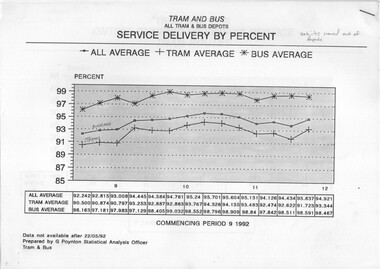
... Report - set of 10 A4 landscape sheets stapled in the top right hand corner providing tram and bus reporting for the three months commencing Sept. 1992. 1 - service delivery by percent, buses, trams and average - vehicles crewed out of depot 2 - on time running weekdays - tram routes 3 - ditto - government bus routes 4 - complaints 5 - platform staff ratio 6 - platform staff ratio to other 7 - cost per kilometre 8 - priority absenteeism 9 - new workcare claims 10 - kilometres per accident / incident - 1991/1992...Melbourne Tram Museum 8 Wallen Road Hawthorn melbourne Trams tramways Accidents Reports Statistics Trams Buses PTC Report - set of 10 A4 landscape sheets stapled in the top right hand corner providing tram and bus reporting for the three months commencing Sept. 1992. 1 - service delivery by percent, buses, trams and average - vehicles crewed out of depot 2 - on time running weekdays - tram routes 3 - ditto - government bus routes 4 - complaints 5 - platform staff ratio 6 - platform staff ratio to other 7 - cost per kilometre 8 - priority absenteeism 9 - new workcare claims 10 - kilometres per accident / incident - 1991/1992 "Tram and Bus - All Tram and Bus Depots - Service Delivery Reports" Document Report Public Transport Corporation (PTC) ...Report - set of 10 A4 landscape sheets stapled in the top right hand corner providing tram and bus reporting for the three months commencing Sept. 1992. 1 - service delivery by percent, buses, trams and average - vehicles crewed out of depot 2 - on time running weekdays - tram routes 3 - ditto - government bus routes 4 - complaints 5 - platform staff ratio 6 - platform staff ratio to other 7 - cost per kilometre 8 - priority absenteeism 9 - new workcare claims 10 - kilometres per accident / incident - 1991/1992trams, tramways, accidents, reports, statistics, trams, buses, ptc -
Moorabbin Air Museum
Document (Item) - Sheila Scott's World Flight General Information Dossier
... Around the world flight flying Piper PA-24-260B Comanche G-ATOY .Departed London England 18.05.1966 returning London England 20.06.1966.Flight covered approximately 46,121 kilometres and took 189 actual flying hours over 33 days....Moorabbin Air Museum Moorabbin Airport 12 First Street Moorabbin melbourne Around the world flight flying Piper PA-24-260B Comanche G-ATOY .Departed London England 18.05.1966 returning London England 20.06.1966.Flight covered approximately 46,121 kilometres and took 189 actual flying hours over 33 days. ... -
 Ballarat Heritage Services
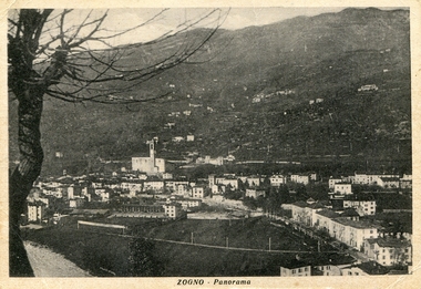
Photograph - Photograph - Black and White, Zogno, Lombardy, Italy
... It is located about 50 kilometres northeast of Milan and about 11 kilometres north of Bergamo....It is located about 50 kilometres northeast of Milan and about 11 kilometres north of Bergamo. zogno italy gervasoni Black and white photographic postcard of Zogno in Lombardy, Italy. ...Zogno is a comune (municipality) in the Province of Bergamo, Lombardy, Italy. It is located about 50 kilometres northeast of Milan and about 11 kilometres north of Bergamo.Black and white photographic postcard of Zogno in Lombardy, Italy. zogno, italy, gervasoni -
 Greensborough Historical Society
Book, Shire of Eltham Handbook 1985-86, 1985_
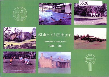
... The Shire of Eltham was a Local Government Area located about 25 kilometres northeast of Melbourne. The shire covered an area of 277.13 square kilometres and existed from 1856 until 1994....Greensborough Historical Society 34A Glenauburn Road Lower Plenty Lower Plenty melbourne The Shire of Eltham was a Local Government Area located about 25 kilometres northeast of Melbourne. The shire covered an area of 277.13 square kilometres and existed from 1856 until 1994. ...The Shire of Eltham was a Local Government Area located about 25 kilometres northeast of Melbourne. The shire covered an area of 277.13 square kilometres and existed from 1856 until 1994.Guide to services provided by Shire of Eltham40 pages, illus. Front cover is a collage of Eltham sceneseltham, shire of eltham, handbooks -
 Greensborough Historical Society
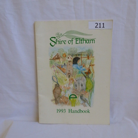
Book, Shire of Eltham, Shire of Eltham 1993 Handbook, 1993_
... The Shire of Eltham was a Local Government Area located about 25 kilometres northeast of Melbourne. The shire covered an area of 277.13 square kilometres and existed from 1856 until 1994....Greensborough Historical Society 34A Glenauburn Road Lower Plenty Lower Plenty melbourne The Shire of Eltham was a Local Government Area located about 25 kilometres northeast of Melbourne. The shire covered an area of 277.13 square kilometres and existed from 1856 until 1994. ...The Shire of Eltham was a Local Government Area located about 25 kilometres northeast of Melbourne. The shire covered an area of 277.13 square kilometres and existed from 1856 until 1994.Guide to services provided by Shire of Eltham in 1993.40 pages, illus. Front cover is a montage depicting various elements of the Eltham community. Handbook printed on recycled paper.eltham, shire of eltham, handbooks -
 Greensborough Historical Society
Book, Shire of Eltham, Shire of Eltham Handbook 1988, 1988_
... The Shire of Eltham was a Local Government Area located about 25 kilometres northeast of Melbourne. The shire covered an area of 277.13 square kilometres and existed from 1856 until 1994....Greensborough Historical Society 34A Glenauburn Road Lower Plenty Lower Plenty melbourne The Shire of Eltham was a Local Government Area located about 25 kilometres northeast of Melbourne. The shire covered an area of 277.13 square kilometres and existed from 1856 until 1994. ...The Shire of Eltham was a Local Government Area located about 25 kilometres northeast of Melbourne. The shire covered an area of 277.13 square kilometres and existed from 1856 until 1994.Guide to services provided by Shire of Eltham52 pages, illus. Front cover is a copy of the painting "Panton Hill" by David Armfield.eltham, shire of eltham, handbooks -
 Greensborough Historical Society
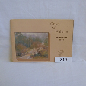
Book, Shire of Eltham, Shire of Eltham Handbook 1991, 1991_
... The Shire of Eltham was a Local Government Area located about 25 kilometres northeast of Melbourne. The shire covered an area of 277.13 square kilometres and existed from 1856 until 1994....Greensborough Historical Society 34A Glenauburn Road Lower Plenty Lower Plenty melbourne The Shire of Eltham was a Local Government Area located about 25 kilometres northeast of Melbourne. The shire covered an area of 277.13 square kilometres and existed from 1856 until 1994. ...The Shire of Eltham was a Local Government Area located about 25 kilometres northeast of Melbourne. The shire covered an area of 277.13 square kilometres and existed from 1856 until 1994.Annual guide to services in Shire of Eltham60 pages, Illus. Printed on beige paper. Front cover has a copy of the painting "Brougham Street Bridge" by Hilary Jackman.eltham, shire of eltham, handbooks -
 Greensborough Historical Society
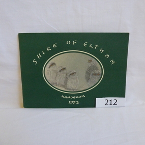
Book, Shire of Eltham, Shire of Eltham Handbook 1992, 1992_
... The Shire of Eltham was a Local Government Area located about 25 kilometres northeast of Melbourne. The shire covered an area of 277.13 square kilometres and existed from 1856 until 1994....Greensborough Historical Society 34A Glenauburn Road Lower Plenty Lower Plenty melbourne The Shire of Eltham was a Local Government Area located about 25 kilometres northeast of Melbourne. The shire covered an area of 277.13 square kilometres and existed from 1856 until 1994. ...The Shire of Eltham was a Local Government Area located about 25 kilometres northeast of Melbourne. The shire covered an area of 277.13 square kilometres and existed from 1856 until 1994.Annual guide to services in Shire of Eltham72 pages, illus. Front cover has a copy of a sketch "Frogmouths" by Margo Kroyer Pederson on dark green cover. Printed on recycled paper.eltham, shire of eltham, handbooks -
 Greensborough Historical Society
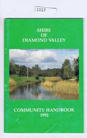
Book, Shire of Diamond Valley, The Shire of Diamond Valley Handbook 1992, 1992_
... The Shire of Diamond Valley was a Local Government Area located about 20 kilometres northeast of Melbourne. The shire covered an area of 74.38 square kilometres and existed from 1964 until 1994....Greensborough Historical Society 34A Glenauburn Road Lower Plenty Lower Plenty melbourne The Shire of Diamond Valley was a Local Government Area located about 20 kilometres northeast of Melbourne. The shire covered an area of 74.38 square kilometres and existed from 1964 until 1994. ...The Shire of Diamond Valley was a Local Government Area located about 20 kilometres northeast of Melbourne. The shire covered an area of 74.38 square kilometres and existed from 1964 until 1994.Annual guide to services in Shire of Diamond Valley54 pages, illus (some colour), maps. Front cover photograph:Kalparrin Gardens Greensboroughshire of diamond valley, greensborough, handbooks -
 Greensborough Historical Society
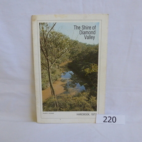
Book, Shire of Diamond Valley, The Shire of Diamond Valley Handbook 1977, 1977_
... The Shire of Diamond Valley was a Local Government Area located about 20 kilometres northeast of Melbourne. The shire covered an area of 74.38 square kilometres and existed from 1964 until 1994....Greensborough Historical Society 34A Glenauburn Road Lower Plenty Lower Plenty melbourne The Shire of Diamond Valley was a Local Government Area located about 20 kilometres northeast of Melbourne. The shire covered an area of 74.38 square kilometres and existed from 1964 until 1994. ...The Shire of Diamond Valley was a Local Government Area located about 20 kilometres northeast of Melbourne. The shire covered an area of 74.38 square kilometres and existed from 1964 until 1994.Annual guide to services in Shire of Diamond Valley18pages, illus (some colour), maps. Front cover photograph "Plenty Gorge".shire of diamond valley, greensborough, handbooks -
 Greensborough Historical Society
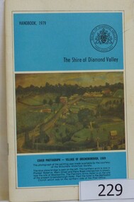
Book, The Shire of Diamond Valley Handbook 1979, 1979_
... The Shire of Diamond Valley was a Local Government Area located about 20 kilometres northeast of Melbourne. The shire covered an area of 74.38 square kilometres and existed from 1964 until 1994....Greensborough Historical Society 34A Glenauburn Road Lower Plenty Lower Plenty melbourne The Shire of Diamond Valley was a Local Government Area located about 20 kilometres northeast of Melbourne. The shire covered an area of 74.38 square kilometres and existed from 1964 until 1994. ...The Shire of Diamond Valley was a Local Government Area located about 20 kilometres northeast of Melbourne. The shire covered an area of 74.38 square kilometres and existed from 1964 until 1994.Annual guide to services in Shire of Diamond Valley32 pages, illus (some col.), maps. Cover illustration is a copy of the Ellis painting "Village of Greensborough 1889".shire of diamond valley, greensborough, handbooks -
 Greensborough Historical Society
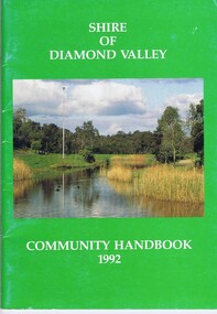
Book, Shire of Diamond Valley, Shire of Diamond Valley Community Handbook 1992, 1992_
... The Shire of Diamond Valley was a Local Government Area located about 20 kilometres northeast of Melbourne. The shire covered an area of 74.38 square kilometres and existed from 1964 until 1994....The Shire of Diamond Valley was a Local Government Area located about 20 kilometres northeast of Melbourne. The shire covered an area of 74.38 square kilometres and existed from 1964 until 1994. ...Guide to services provided by Shire of Diamond Valley. The Shire of Diamond Valley was a Local Government Area located about 20 kilometres northeast of Melbourne. The shire covered an area of 74.38 square kilometres and existed from 1964 until 1994.Annual guide to services in Shire of Diamond Valley52 pages, col illus., maps. Cover illustration of Kalparrin Gardens Greensboroughshire of diamond valley -
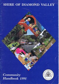
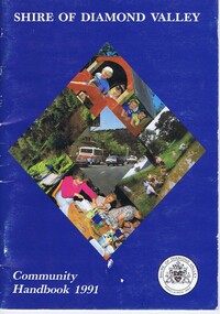 Greensborough Historical Society
Book, Shire of Diamond Valley, Shire of Diamond Valley Community Handbook 1991, 1991_
... The Shire of Diamond Valley was a Local Government Area located about 20 kilometres northeast of Melbourne. The shire covered an area of 74.38 square kilometres and existed from 1964 until 1994....The Shire of Diamond Valley was a Local Government Area located about 20 kilometres northeast of Melbourne. The shire covered an area of 74.38 square kilometres and existed from 1964 until 1994. ...Guide to services provided by Shire of Diamond Valley. The Shire of Diamond Valley was a Local Government Area located about 20 kilometres northeast of Melbourne. The shire covered an area of 74.38 square kilometres and existed from 1964 until 1994.Annual guide to services in Shire of Diamond Valley36 pages, col. illus., maps. Front cover is a collage of scenes from Diamond Valley, back cover illustration of a copy of "Summer Panorama, Tabletop, NSW" by Max Dimmack, from the Shire of Diamond Valley Art Collection.shire of diamond valley -
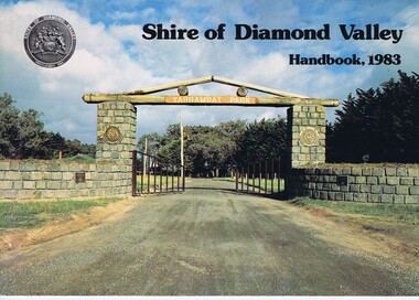 Greensborough Historical Society
Book, Shire of Diamond Valley Handbook 1983, 1983_
... The Shire of Diamond Valley was a Local Government Area located about 20 kilometres northeast of Melbourne. The shire covered an area of 74.38 square kilometres and existed from 1964 until 1994....The Shire of Diamond Valley was a Local Government Area located about 20 kilometres northeast of Melbourne. The shire covered an area of 74.38 square kilometres and existed from 1964 until 1994. ...Guide to services provided by Shire of Diamond Valley. The Shire of Diamond Valley was a Local Government Area located about 20 kilometres northeast of Melbourne. The shire covered an area of 74.38 square kilometres and existed from 1964 until 1994.Annual guide to services in Shire of Diamond Valley32 pages, col illus., maps. Cover illustration of the bluestone gateway, main entrance to Yarrambat Park, opened 1982.shire of diamond valley, greensborough, handbooks -
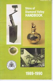 Greensborough Historical Society
Booklet, Shire of Diamond Valley Handbook 1989-1990, 1989_
... The Shire of Diamond Valley was a Local Government Area located about 20 kilometres northeast of Melbourne. The shire covered an area of 74.38 square kilometres and existed from 1964 until 1994....The Shire of Diamond Valley was a Local Government Area located about 20 kilometres northeast of Melbourne. The shire covered an area of 74.38 square kilometres and existed from 1964 until 1994. ...Guide to services provided by Shire of Diamond Valley. The Shire of Diamond Valley was a Local Government Area located about 20 kilometres northeast of Melbourne. The shire covered an area of 74.38 square kilometres and existed from 1964 until 1994.Annual guide to services in Shire of Diamond Valley32 pages, col illus., maps. Cover illustration of items from the Diamond Valley Shire Art Collection. 2 copiesshire of diamond valley, greensborough, handbooks -
 Greensborough Historical Society
Book, Shire of Diamond Valley Community Handbook 1991, 1991_
... The Shire of Diamond Valley was a Local Government Area located about 20 kilometres northeast of Melbourne. The shire covered an area of 74.38 square kilometres and existed from 1964 until 1994....The Shire of Diamond Valley was a Local Government Area located about 20 kilometres northeast of Melbourne. The shire covered an area of 74.38 square kilometres and existed from 1964 until 1994. ...Guide to services provided by Shire of Diamond Valley. The Shire of Diamond Valley was a Local Government Area located about 20 kilometres northeast of Melbourne. The shire covered an area of 74.38 square kilometres and existed from 1964 until 1994.Annual guide to services in Shire of Diamond Valley36 pages, col illus., maps. Front cover is a collage of scenes from Diamond Valley, back cover illustration of a copy of "Summer Panorama, Tabletop, NSW" by Max Dimmack, from the Shire of Diamond Valley Art Collection.shire of diamond valley, greensborough, handbooks