Showing 843 items matching " land allotments"
-
 Bendigo Historical Society Inc.
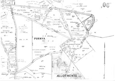
Plan - Jack Lockett Collection: Copies of Mallee land Allotments
... Jack Lockett Collection: Copies of Mallee land Allotments...Dates of Title on the Lockett allotments range from 1857 to 1964 Plan Jack Lockett Collection: Copies of Mallee land Allotments ...John Henry Lockett OAM (22 January 1891 – 25 May 2002) was the oldest man ever in Australia when he died aged 111 years, 123 days. As one of the last surviving veterans of World War I, he was acclaimed as a national hero during the last decade of his life. Lockett was born in the small Victorian town of Waanyarra, near Bendigo. He left school aged nine to work on a local farm. Later, he worked for his uncles in the Mallee. On 24 March 1916, he travelled to Mildura to enlist in the Australian Imperial Force. He served in France with the 38th Battalion, earning promotion to sergeant and was discharged on 20 September 1919. https://en.wikipedia.org/wiki/Jack_Lockett After the war, Jack returned to The Mallee and selected a 640 acres (260 ha) block of land in Linga, Victoria, deciding to make his living as a farmer. In 1923, he married Maybell Ingwerson and they had four children together. In 1963, the couple retired to Bendigo, leaving the farmland (which now covered more than 130,000 acres (53,000 ha), in the care of their children and grandchildren . People with the name Burstall are in Lockett Family photo (item number 11170.6) Two A3 copies of plans of allotments in northwest Victoria in the Parishes of Mamencoroock and Purnya. Some of the allotments have Lockett and Burstall names. Dates of Title on the Lockett allotments range from 1857 to 1964 jack lockett, mabel ingwersen, malley farm allotments -
![Map, Plan of Subdivision [Allotments along Lerderderg, George and McFarland Streets]](/media/collectors/5e461d8021ea67224c82f2a1/items/675d7243165f146b8adfc656/item-media/675d72d7165f146b8adfc859/item-fit-380x285.jpg?cb=6) Bacchus Marsh & District Historical Society
Bacchus Marsh & District Historical SocietyMap, Plan of Subdivision [Allotments along Lerderderg, George and McFarland Streets]
... Lerderderg Street Land Allotments...This map shows allotments of land on the northern side of Lerderderg Street from Gisborne Road through to the approximate site of the present day Bacchus Marsh Primary School. ...Single page map showing house block size land allotments in the Lerderderg, George Street and McFarland Street area of Bacchus Marsh with larger allotments north of this area towards Masons Lane also shown. ...Bacchus Marsh Victoria Maps Lerderderg Street Land Allotments McFarland Street Land Allotments Single page map showing house block size land allotments in the Lerderderg, George Street and McFarland Street area of Bacchus Marsh with larger allotments north of this area towards Masons Lane also shown. ...This map shows allotments of land on the northern side of Lerderderg Street from Gisborne Road through to the approximate site of the present day Bacchus Marsh Primary School. There are also allotments shown on the southern side of McFarland Street between George Street and Gisborne Road. Larger allotments of land are shown extending northwards towards Masons Lane. Inscribed at the top of the map are the words, 'Plan of Subdivision of Cr Pors (Crown Portions) 12 & 13 & Allotments 1,2,3,4, Block 3, Parish of Korkuperrimul, County of Bourke'. The date of the map has not been established but the absence of the Bacchus Marsh Primary School on the map suggests it may have been produced prior to 1865 when the primary school was built in Lerderderg Street.Single page map showing house block size land allotments in the Lerderderg, George Street and McFarland Street area of Bacchus Marsh with larger allotments north of this area towards Masons Lane also shown. Scale 150 feet to 1 inch. Part of a set of maps which are pasted into a bound volume containing 76 maps or plans in total. High resolution digital image stored on BMDHS computer network. bacchus marsh victoria maps, lerderderg street land allotments, mcfarland street land allotments -
 Bacchus Marsh & District Historical Society
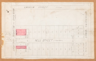
Map, Main Road and Gell Street Allotments
... ...Gell Street Land Allotments...The total area of the map encompasses Main Road, Church Street, Lerderderg Street and Gell Street. 36 allotments of land are shown. Three allotments which connect to Main Road are shaded in pink. ...Single page map showing allotments of land along the Main Road (Main Street) and Gell Street areas of Bacchus Marsh. ...Later reports in the Express on 1 November 1873, page 2, column 2 advertised 14 allotments of land in Gell Street for sale. Bacchus Marsh Victoria Maps Gell Street Land Allotments Main Street Land Allotments Single page map showing allotments of land along the Main Road (Main Street) and Gell Street areas of Bacchus Marsh. ...This map shows allotments of land along Gell Street Bacchus Marsh running between Main Road (now called Main Street) and Lerderderg Street. The total area of the map encompasses Main Road, Church Street, Lerderderg Street and Gell Street. 36 allotments of land are shown. Three allotments which connect to Main Road are shaded in pink. The date of the map has not been established but the National Bank building erected in 1865 near the Border Inn is indicated which indicates that the map dates from after 1865. Reports in the Bacchus Marsh Express newspaper on 5 March 1870, page 2, column 6 announced building lots in Gell Street had been withdrawn from sale by the agent J.E. Crook. Later reports in the Express on 1 November 1873, page 2, column 2 advertised 14 allotments of land in Gell Street for sale. Single page map showing allotments of land along the Main Road (Main Street) and Gell Street areas of Bacchus Marsh. Part of a set of maps which are pasted into a bound volume containing 76 maps or plans in total. High resolution digital image stored on BMDHS computer network. bacchus marsh victoria maps, gell street land allotments, main street land allotments -
 Federation University Historical Collection
Document, Ballarat School of MInes Memorandum of Association
... ...land allotments...Barker Library (top floor) Mount Helen goldfields ballarat school of mines memorandum of association land allotments Signed on front 'R. Hollioake' Ballarat School of MInes Memorandum of Association Ballarat School of MInes Memorandum of Association Document ...Ballarat School of MInes Memorandum of AssociationSigned on front 'R. Hollioake'ballarat school of mines, memorandum of association, land allotments -
Glen Eira Historical Society
Map - CAPLES PLACE SUBDIVISION
... ... Land Allotments... Subdivisions Documents Maps Glen Eira CAPLES PLACE CAPLES PLACE Subdivision Land Surveys Orrong Road Mulgrave Road Prahran Grove Somerset Road Prahran Grove Prahran Grove East Walk Land Allotments Town Planning Garden Road Map CAPLES PLACE SUBDIVISION ...This file contains a copy of a map of the CAPLES PLACE SUBDIVISION, undated and author unknown. The map provides the dimensions of roads and allotments in the area, including also handwritten notes from the original document and others written directly onto the copy.land subdivisions, documents, maps, glen eira, caples place, caples place subdivision, land surveys, orrong road, mulgrave road, prahran grove, somerset road, prahran grove, prahran grove, east walk, land allotments, town planning, garden road -
 Brimbank City Council
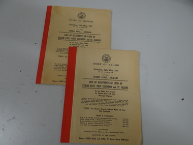
Land Sale Booklet x 2 (2 copies of the same booklet), Sale of allotments of land at Keilor East, West Essendon and St Albans 1954
... Sale of allotments of land at Keilor East, West Essendon and St Albans 1954...Brimbank City Council 301 Hampshire Rd Sunshine melbourne land sale Sale of allotments of land at Keilor East, West Essendon and St Albans 1954 Land Sale Booklet x 2 (2 copies of the same booklet) ...land sale -
 Peterborough History Group
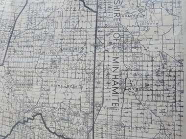
Map - Shire of Warrnambool
... Shows individual land allotments....Shows individual land allotments. Map Shire of Warrnambool ...Map of the area, when Peterborough was part of Warrnambool ShireHistoric map of the area when Peterborough was in the Warrnambool ShireA3 size map, larger view of the whole shire of Warrnambool, and includes adjoining Shire Boundaries. Shows individual land allotments.peterborough, warrnambool shire, old maps -
Linton and District Historical Society Inc
Documents - purchase of land, Purchase of land by David McFadzean, 1872 - Allotment A1A, Township of Linton, Parish of Argyle
... Purchase of land by David McFadzean, 1872 - Allotment A1A, Township of Linton, Parish of Argyle...Allotment A1A Township of Linton... David McFadzean... Victoria. Amending Land...This allowed long-term tenants ("licensees") of government-held land to purchase ("alienate") the land. The allotment is in present-day Jackson Street, Linton....Twelve A4-size photocopies of documents relating to the purchase of an allotment of land - Allotment A1A, measuring 5 acres, 3 roods and 37 perches - within the boundaries of the Township of Linton. ...This allowed long-term tenants ("licensees") of government-held land to purchase ("alienate") the land. The allotment is in present-day Jackson Street, Linton. ...The land was purchased by David McFadzean under the 42nd section of the Amending Land Act, 1865. This allowed long-term tenants ("licensees") of government-held land to purchase ("alienate") the land. The allotment is in present-day Jackson Street, Linton.Twelve A4-size photocopies of documents relating to the purchase of an allotment of land - Allotment A1A, measuring 5 acres, 3 roods and 37 perches - within the boundaries of the Township of Linton. First page is headed "SECTION 31, "LAND ACT 1869". Documents include David McFadzean's application to purchase, notes made about the land and the application by officers of the Board of Land and Works, a plan of the allotment, and information about purchase price and fees.allotment a1a township of linton, david mcfadzean, victoria. amending land act 1865, conveyance, land sales, land purchases, documents and records, james beament -
 Sunshine and District Historical Society Incorporated
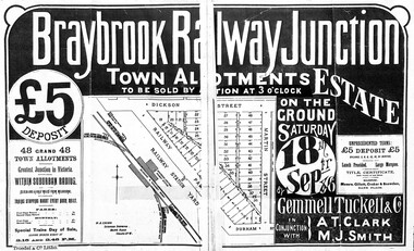
Flyer - Braybrook Railway Junction Housing Allotments 1886, 1886
... Photocopy of the Braybrook Railway Junction sales advertising document showing land allotments location : terms of sale : vendors : solicitors etc from 18th September 1886....Land Sale Braybrook Railway Junction Braybrook Railway Junction town alloments to be sold by auction 3 o'clok on the ground 18th September 1886 Photocopy of the Braybrook Railway Junction sales advertising document showing land allotments location : terms of sale : vendors : solicitors etc from 18th September 1886. ...Braybrook Railway Junction town alloments to be sold by auction 3 o'clok on the ground 18th September 1886land sale, braybrook railway junction -
![Map, Millbank Estate Bacchus Marsh Thursday 4th October 1888 [Land sales], 1924](/media/collectors/5e461d8021ea67224c82f2a1/items/67765662eb6d2cbd24e0797f/item-media/67765682eb6d2cbd24e07a41/item-fit-380x285.jpg?cb=6) Bacchus Marsh & District Historical Society
Bacchus Marsh & District Historical SocietyMap, Millbank Estate Bacchus Marsh Thursday 4th October 1888 [Land sales], 1924
... land and represented a major expansion of residential housing in Bacchus Marsh in the late 19th century. The map includes a wealth of detail about the time of the sale, where it will take place, who the selling agents were, the deposit terms for purchases and details of a special train from Melbourne to Bacchus Marsh on sale day. The location of the allotments...Single page map showing land allotments for sale at auction in Bacchus Marsh in October 1888. ...Land Sales Bacchus Marsh Land Subdivsion Bacchus Marsh Housing Estates Land Sales Bacchus Marsh Grant Family Bacchus Marsh Millbank Estate Land Sales Single page map showing land allotments for sale at auction in Bacchus Marsh in October 1888. ...The Millbank Estate was a parcel of land close to the centre of the shopping area of Bacchus Marsh which was sub-divided and offered for sale in 62? lots on the 4th October 1888. The lots had frontages to Ballarat Road (Main Street), Maddingley Road (now Grant Street), Turner Street, Millbank Street, Clarinda Road (now Clarinda Street), and an unnamed street south of Turner Street (possibly known as Grant Street at this time) which connected to Maddingley Road through the vicinity of the present day Bacchus Marsh Hospital. This was a significant sub-division of land and represented a major expansion of residential housing in Bacchus Marsh in the late 19th century. The map includes a wealth of detail about the time of the sale, where it will take place, who the selling agents were, the deposit terms for purchases and details of a special train from Melbourne to Bacchus Marsh on sale day. The location of the allotments in relation to the shopping and commercial area of Bacchus Marsh, Maddingley and the railway station are indicated on an inset map within the overall map and poster. The Millbank Estate area was an area which had once belonged to the Grant family who were prominent early citizens of Bacchus Marsh and lived in a house in this area known as 'Millbank'.This land sale map is a typical example of housing estate land sales advertising maps produced by real estate agents in this era. The map is significant for the detailed information it provides about when and where land was sold for new housing estates in Bacchus Marsh in the late nineteenth century.Single page map showing land allotments for sale at auction in Bacchus Marsh in October 1888. A significant portion of the map is missing from the bottom right side. land sales bacchus marsh, land subdivsion bacchus marsh, housing estates land sales bacchus marsh, grant family bacchus marsh, millbank estate land sales -
 Bacchus Marsh & District Historical Society
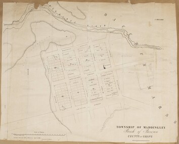
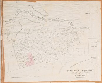
Map, Maddingley Township, Parish of Parwan, County of Grant, 1856
... A single page paper map showing land allotments, streets, and natural watercourses in the township of Maddingley. ...Meikle) A single page paper map showing land allotments, streets, and natural watercourses in the township of Maddingley. ...Maddingley is a locality or township within the broader township area of Bacchus Marsh. This map is dated 1856 but is based on an earlier survey in 1843. The main area of Maddingley shown on this map is an area bounded by Bacchus Street, Moore Street, Griffith Street and Franklin Street. Other streets visible are Inglis Street, Labilliere Street, McCrae Street. The area to the east of Franklin Street is not sub-divided and is described as an 'alluvial flat. A single page paper map showing land allotments, streets, and natural watercourses in the township of Maddingley. The map is pasted into a bound volume containing 76 maps or plans in total. Two inscriptions: 1. A.J. Skene Surveyor, 1843. ; 2. Surveyor-General's Office Melbourne, Sept 6, 1856. (Lithographed by R. Meikle)bacchus marsh victoria maps, maddingley victoria maps, land use, maddingley victoria history -
 Whitehorse Historical Society Inc.
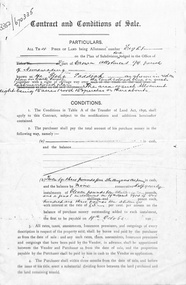
Document, Contract and conditions of sale, 1909
... Copy of contract dated 19 April 1909 between the Freehold Investment and Banking Company of Australia Ltd and Julius Draeger. Portion of land allotment 94 known as Glebe Paddock....Whitehorse Historical Society Inc. 2-10 Deep Creek Road Mitcham melbourne land subdivision glebe paddock draeger carl julius otto freehold investment and banking company of australia ltd t. r. b. morton & son Copy of contract dated 19 April 1909 between the Freehold Investment and Banking Company of Australia Ltd and Julius Draeger. Portion of land allotment 94 known as Glebe Paddock. Contract and conditions of sale Document Document ...Copy of contract dated 19 April 1909 between the Freehold Investment and Banking Company of Australia Ltd and Julius Draeger. Portion of land allotment 94 known as Glebe Paddock.non-fictionland subdivision, glebe paddock, draeger, carl julius otto, freehold investment and banking company of australia ltd, t. r. b. morton & son -
 Whitehorse Historical Society Inc.
Certificate - Land Title document, Crown Allotment, 5/11/1909
... Certificate of Title dated 5/11/1909 covering land in Shady Grove Nunawading purchased by Mary Higgins. Crown Land Allotment No. 116 Parish of Nunawading County of Bourke....Crown Allotment Certificate Land Title document ...Certificate of Title dated 5/11/1909 covering land in Shady Grove Nunawading purchased by Mary Higgins. Crown Land Allotment No. 116 Parish of Nunawading County of Bourke.land titles, higgins, mary, holmes, dave, shady grove nunawading no.76, helen -
 Whitehorse Historical Society Inc.
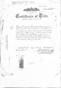
Certificate - Certificate of Title, Crown Allotment, 12/04/1904
... Certificate of Title dated 12/4/1904 covering land in Shady Grove, Nunawading purchased by David Duncan Butchart Wilson. Crown Land Allotment No. 116 Parish of Nunawading County of Bourke...Whitehorse Historical Society Inc. 2-10 Deep Creek Road Mitcham melbourne land titles wilson david duncan butchart shady grove nunawading no. 76 higgins mary alcock horace holmes dave thumberstone henry helen Certificate of Title dated 12/4/1904 covering land in Shady Grove, Nunawading purchased by David Duncan Butchart Wilson. Crown Land Allotment No. 116 Parish of Nunawading County of Bourke Crown Allotment Certificate Certificate of Title ...Certificate of Title dated 12/4/1904 covering land in Shady Grove, Nunawading purchased by David Duncan Butchart Wilson. Crown Land Allotment No. 116 Parish of Nunawading County of Bourkeland titles, wilson, david duncan butchart, shady grove nunawading no. 76, higgins, mary, alcock, horace, holmes, dave, thumberstone, henry, helen -
 Bendigo Historical Society Inc.
Document - JOHANSON COLLECTION: RICHARDS TO MELROSE CONVEYANCE
... Douglas Jones, Solicitor, Bendigo. Land allotment 10, section 80, Bendigo....Douglas Jones, Solicitor, Bendigo. Land allotment 10, section 80, Bendigo. Document JOHANSON COLLECTION: RICHARDS TO MELROSE CONVEYANCE ...Legal document: on front 21st June 1921. Mrs. Catherine Richards to Mrs. Isabella Melrose, conveyance. On bottom : Fred. Douglas Jones, Solicitor, Bendigo. Land allotment 10, section 80, Bendigo.bendigo, land sales -
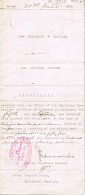
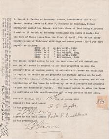 Bendigo Historical Society Inc.
Document - EDWIN BUCKLAND COLLECTION: AGREEMENT BY HAROLD E. TAYLOR AND VICTOR P. BUCKLAND
... Buckland re leasing of land Allotment 3, Section 3 12 Parish of Goornong, Containing 301 acres 3 roods for the term of Three years....Buckland re leasing of land Allotment 3, Section 3 12 Parish of Goornong, Containing 301 acres 3 roods for the term of Three years. ...Document. Agreement by Harold E. Taylor and Victor P. Buckland re leasing of land Allotment 3, Section 3 12 Parish of Goornong, Containing 301 acres 3 roods for the term of Three years. -
Glen Eira Historical Society
Letter - Rosstown Railway
... ... Allotments... Land...allotment known as Webber’s. The agreement is outlined in the letter in what appears to be Chinese characters, and includes the marks of Robert Lundon and Soon Hang Hi. File note from Joy Wu states that the calligraphy is not Mandarin or traditional Chinese. 2/Three sheets of hand-written working notes with information taken from the Victorian Government Gazette on THE ROSSTOWN AND MURRUMBEENA LAND COMPANY LIMITED, THE ROSSTOWN JUNCTION RAILWAY AND PROSPERITY COMPANY LIOMITED, and THE ROSSTOWN JUNCTION, ELSTERNWICK, AND OAKLEIGH RAILWAY COMPANY LIMITED, covering dates between 1887 and 1894. ...Wickham Francis Dawe Bryant Jane East Brighton Railway Station Railway Stations Maps Allotments Land Titles Roads and Streets Rosstown Rail Trail City of Glen Eira Tourism Trains Tourism Information Bureaus Tours Pamphlets Elsternwick Railway Park Oakleigh Junction Princes Park EE Gunn Reserve Packer Park Sites Jowett D.F. ...This file contains four items: 1/A black and white photocopy of a letter dated either 07/08/1889 or 09/08/1889, from Robert Lundon to an unidentified recipient discussing an agreement reached between the author – on behalf of the recipient – and Soon Hang Hi in regard, in regards to the allotment known as Webber’s. The agreement is outlined in the letter in what appears to be Chinese characters, and includes the marks of Robert Lundon and Soon Hang Hi. File note from Joy Wu states that the calligraphy is not Mandarin or traditional Chinese. 2/Three sheets of hand-written working notes with information taken from the Victorian Government Gazette on THE ROSSTOWN AND MURRUMBEENA LAND COMPANY LIMITED, THE ROSSTOWN JUNCTION RAILWAY AND PROSPERITY COMPANY LIOMITED, and THE ROSSTOWN JUNCTION, ELSTERNWICK, AND OAKLEIGH RAILWAY COMPANY LIMITED, covering dates between 1887 and 1894. The notes concern meetings and creditors claims relevant to the companies, with reference numbers for the information source. Date and author of the notes are not recorded. 3/A black and white photocopy of the a partial map of the Rosstown Railway and surrounding area, undated. The map includes the names of landholders in the areas of Brighton, Garden Vale and Elsternwick, as well as other railway lines present in the region. 4/A fold-out map and guide of the Rosstown Rail Trail, including a brief general history of Caulfield as well as a more extensive biography of William Murray Ross and the Rosstown Railway. The map marks and describes significant sites along the trail, including photographs of some of these sites, provided by DF Jowett.documents, correspondence, webber’s, lundon robert, chinese characters, ethnic communities, signatures, text, settlements, taxes, fraser john grieves, lovell r.h., price davies, meetings, communication activities, soon hang hi, commercial events and activities, the rosstown and murrumbeena land company limited, victorian government gazette, bulmer richard, parry john, osment henry, shareholders, creditors claims, the rosstown junction railway and property company limited, finch and best, lawyers, the rosstown junction elsternwick and oakleigh railway company limited, cameron w.c., phillips p.d., garden vale, elsternwick, elsternwick railway station, rosstown, rosstown railway, thomas street, bay street, kooyong road, melbourne and brighton railway, hawthorn road, bambra road, caulfield and frankston railway, booran road, grange road, koornang road, murrumbeena road, north road, north road railway station, east brighton railway station, south road, railway routes, railway lines, railways, land transport, murphy j., caulfield, hamilton t.f., dane p., holloway, webb, ailee john, payne t.b., brodie chas, dane john, o’neil h., mccombie john, mcmillane a., smyth c.d., cooper, ebden, landholders, jeffrey j.d., gill j., balcombe a.e., cooper h., mcnab j., white j., sutherland j., greeves a.f.a., newton m.c., chamley f.b., fowler j., inglis p., grant t., stooke j., swanson g., cochrane c., adams e.b., mccombie thas, keyes robert, brighton cemetery, burials grounds and graveyards, war-ein road, were j.b., holland j., mcmahon c., winter t.l.m., dendy henry, mitchell w., jackson s., were j.e., wickham francis dawe, bryant jane, east brighton railway station, railway stations, maps, allotments, land titles, roads and streets, rosstown rail trail, city of glen eira, tourism, trains, tourism information bureaus, tours, pamphlets, elsternwick railway park, oakleigh junction, princes park, ee gunn reserve, packer park, sites, jowett d.f., weickhardt i.g., return to rosstown: railways land sales and sugar beet ventures in caulfield, land sales, walking trails, ross william murray, transport objects, locomotion, walking, cycling, driving, sports, country mansions, people, caulfield john, builders, construction and demolition workers, occupations, careers, professionals, topography, geology, landforms, horticulture, market gardens, primary industry workers, city of caulfield, mood kee, pennington harold, annual general meetings, caulfield town hall, glen eira city council, carnegie, carnegie station, rosstown station, people by circumstance, migrants, sugar beet, sugar beet mill, sugar beet industry, mills, factories, sea beach lines, bent thomas, parliamentary representatives, neville street, miller street, lemann’s swamp reserve, koornang park, cane sugar industry, breweries, rabbit processing plants, health establishments, hospitals, food production establishments, abattoirs, thieves, social problems, vagrants, theft, squatting, financial economics, debt, finance industry, insurance companies, company managers, bentleigh, ross leila, the grange, leila road, wild cherry road, financial trouble, mortgages, gisborne street, archibald street, riddell parade, victoria railways, glen huntly road, clarence street, college street, gladstone parade, parrell street, aileen avenue, seaview street, land subdivisions, dover street, sussex street, landfill, marara road, booran road, woodville avenue, dorothy avenue, ormond park, royal avenue, ormond railway station, oakleigh road, melten avenue, miller street, munro avenue, lord reserve, neerim road, toolambool road, the rosstown hotel, rosanna street, murrumbeena crescent, commercial establishments, the national bank, rosstown road, kangaroo road, poath road, freda street, hughesdale kindergarten, oakleigh council, hughesdale community centre, civic establishments, galbally reserve, plaques, warrigal road, out and about brochures, orion estate -
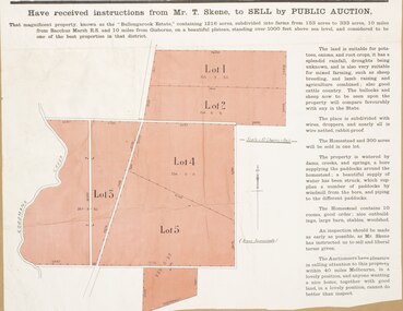 Bacchus Marsh & District Historical Society
Map, Bullengarook Estate Property Sale. 1911
... A single page paper map showing land allotments for sale from the Bullengarook Estate. ...Land Sales Bacchus Marsh Bullengarook Land Sales Bullengarook Estate Bullengarook Vic History A single page paper map showing land allotments for sale from the Bullengarook Estate. ...Bullengarook is a locality located 19 kilometers north of Bacchus Marsh. Pastoral leases for European colonists were granted to people for this area from around the 1840s.The Bullengarook Estate was part of these early pastoral holdings. By the 1900s the property had been owned by the Skene family for a number of years. In early 1911 the property then consisting of 300 acres and the homestead upon it was offered for sale in one lot. It appears however that the sale of the property did not go through in 1911. It was later leased by Thomas Skene to a Mr Coutts in 1915 and ultimately and at a later stage the property was sold by the Skene family.A single page paper map showing land allotments for sale from the Bullengarook Estate. The map is pasted into a bound volume containing 76 maps or plans in total. High resolution digital image stored on BMDHS computer network. land sales bacchus marsh, bullengarook land sales, bullengarook estate, bullengarook vic history -
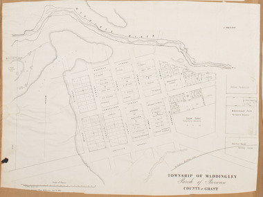 Bacchus Marsh & District Historical Society
Map, Maddingley Township, Parish of Parwan, 1880s
... A single page paper map showing land allotments, streets, rivers, creeks, park lands, the railway line and Bacchus Marsh railway station in the township of Maddingley. ...Bacchus Marsh Victoria Maps Maddingley Victoria Maps Land Use Maddingley Victoria History Bottom of Map: Surveyor-General's Office, Melbourne, Sept 6th, 1856 A single page paper map showing land allotments, streets, rivers, creeks, park lands, the railway line and Bacchus Marsh railway station in the township of Maddingley. ...This map is dated Sept. 6th 1856. However places in the township of Maddingley which did not appear until the late 1880s such as the Bacchus Marsh Railway Station and line are shown on this map in their correct locations. This suggests the map has been derived from an earlier map. An earlier date of 1843 with a surveyor's name preceding it can also be seen on the map. The map is important because it indicates the location and dimensions of early but now discontinued use of land such as the showgrounds and police paddock and a site reserved for the Church of England which was not ultimately used for a permanent church. A single page paper map showing land allotments, streets, rivers, creeks, park lands, the railway line and Bacchus Marsh railway station in the township of Maddingley. The map is pasted into a bound volume containing 76 maps or plans in total. Bottom of Map: Surveyor-General's Office, Melbourne, Sept 6th, 1856bacchus marsh victoria maps, maddingley victoria maps, land use, maddingley victoria history -
 Bacchus Marsh & District Historical Society
Map, Maddingley Township, Parish of Parwan, circa 1890s
... A single page paper map showing land allotments, streets, rivers, creeks, park lands, the railway line and Bacchus Marsh railway station in the township of Maddingley. ...Bacchus Marsh Victoria Maps Maddingley Victoria Maps Land Use Maddingley Victoria History A single page paper map showing land allotments, streets, rivers, creeks, park lands, the railway line and Bacchus Marsh railway station in the township of Maddingley. ...Maddingley is a locality or township within the broader township area of Bacchus Marsh. This map is not dated. However features in Maddingley which appeared in the 1880s and 1890s are present in the map, These include the Bacchus Marsh Railway Station and the Bacchus Marsh Showgrounds. The main residential and commercial area of Maddingley is shown on this map in an area bounded by Bacchus Street, Barry Street, Griffith Street and Maddingley Road. Other streets visible are Franklin Street, Inglis Street, Labilliere Street, McCrae Street, Moore Street and part of Station Street.A single page paper map showing land allotments, streets, rivers, creeks, park lands, the railway line and Bacchus Marsh railway station in the township of Maddingley. The map is pasted into a bound volume containing 76 maps or plans in total. bacchus marsh victoria maps, maddingley victoria maps, land use, maddingley victoria history -
Lakes Entrance Historical Society
Map - Map Allotments Colquhoun East, Department Lands and Survey, 10/3/1934
... Land owners and allotments Princes Highway Forest...Lakes Entrance Historical Society 4 Marine Parade Lakes Entrance gippsland land owners Forest Roads and Streets Land owners and allotments Princes Highway Forest Map Map Allotments Colquhoun East Department Lands and Survey H J Green Printer ...Land owners and allotments Princes Highway Forestland owners, forest, roads and streets -
 Bendigo Historical Society Inc.
Document - MCCOLL, RANKIN AND STANISTREET COLLECTION: CONVEYANCE DOCUMENT, 1909
... Frances O. Lacey of land, Allotment 49, Sec. C. 'Sheephead Gully' to Deborah Reef Gold Mining Company No Liability. ...Frances O. Lacey of land, Allotment 49, Sec. C. 'Sheephead Gully' to Deborah Reef Gold Mining Company No Liability. ...Document: conveyance between Mrs. Charlotte M.E. Meager to Mrs. Frances O. Lacey of land, Allotment 49, Sec. C. 'Sheephead Gully' to Deborah Reef Gold Mining Company No Liability. Dated 21st. March , 1912. Handwritten conveyancing document on parchment.McColl, Rankin and Stanistreet:organization, mining, mccoll, rankin and stanistreet, mccoll, rankin and stanistreet: deborah gold mines nl. bendigo, mining -
 Ballan Shire Historical Society
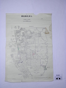
Map - Map. Bungal, Department of Lands and Survey, Bungal, County of Grant, 09/09/1926
... It shows the land allotments with names of owners....It shows the land allotments with names of owners. Bungal, County of Grant Map Map. ...A map of Bungal in the 1920's showing the allotments, and the size, with the names of the residents. It shows the roads and the Western and Eastern Moorarbool River, and the Whipstick State Forest.Cream coloured map of Bungal in the County of Grant, bounded by the the East Moorarbool River on the East, and the State Forest on the South. It is marked with the scale of chains and the number L.358. Lithographed at the Department of Lands and Survey. Melbourne by W. J. Butson on 9.9.1926. It shows the land allotments with names of owners.Coloured pen marks and circled numbers on various areas. Price 2 shillings marked on bottom right hand edge.bungal, kerrit bareet, egerton, lal lal, borhoneyghurk, bungeeltap, ballark, yaloak, gorong, moorarbool west -
 Bacchus Marsh & District Historical Society
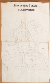
Map, Landsberg Estate Blackwood
... Single page map showing land allotments which made up the Landsberg Estate near Blackwood. ...Bacchus Marsh Victoria Maps Landsberg Estate Blackwood Single page map showing land allotments which made up the Landsberg Estate near Blackwood. ...The date this map was created has not been identified. It was possibly created at the time the Landsberg Estate near Blackwood was subdivided and sold into smaller lots in December 1886.Single page map showing land allotments which made up the Landsberg Estate near Blackwood. Scale 20 chains to 1 inch. The map is pasted into a bound volume containing 76 maps or plans in total. High resolution digital image stored on BMDHS computer network. bacchus marsh victoria maps, landsberg estate blackwood -
![Map, Late the Property of Robert Lawson Esq. [Landsberg Estate Blackwood]](/media/collectors/5e461d8021ea67224c82f2a1/items/67763722eb6d2cbd24dff14f/item-media/677637b7eb6d2cbd24dff29d/item-fit-380x285.jpg?cb=6) Bacchus Marsh & District Historical Society
Bacchus Marsh & District Historical SocietyMap, Late the Property of Robert Lawson Esq. [Landsberg Estate Blackwood]
... Single page map showing land allotments which made up the Landsberg Estate near Blackwood. ...Single page map showing land allotments which made up the Landsberg Estate near Blackwood. ...The date this map was created has not been identified. It was possibly created at the time the Landsberg Estate near Blackwood was subdivided and sold into smaller lots in December 1886. This land once belonged to Robert Lawson who died in 1869. Lawson was a well known school teacher who founded Scotch College in Melbourne before setting up a school near Blackwood. This map is similar to another map in the BMDHS collection titled 'Landsberg Estate Blackwood' Victorian Collections record 459 and was possibly produced at the same time.Single page map showing land allotments which made up the Landsberg Estate near Blackwood. Scale 20 chains to 1 inch. The map is pasted into a bound volume containing 76 maps or plans in total. High resolution digital image stored on BMDHS computer network. At the top of the map: 'Late the Property of Robert Lawson Esq.'bacchus marsh victoria maps, landsberg estate blackwood -
Whitehorse Historical Society Inc.
Document, Part of the history of the Lowen's, n.d
... Lowen Family bought land on Crown Allotment 100 in 1867....Whitehorse Historical Society Inc. 2-10 Deep Creek Road Mitcham melbourne Lowen Family Pioneers Lowen Family bought land on Crown Allotment 100 in 1867. Lowen Family bought land on Crown Allotment 100 in 1867. ...Lowen Family bought land on Crown Allotment 100 in 1867.Lowen Family bought land on Crown Allotment 100 in 1867.Lowen Family bought land on Crown Allotment 100 in 1867.lowen family, pioneers -
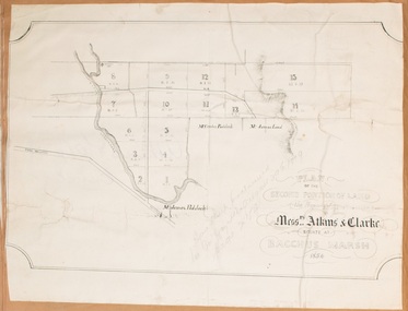 Bacchus Marsh & District Historical Society
Map, Plan of the second portion of the property of Messers Atkins and Clarke situate at Bacchus Marsh 1856
... This plan of land allotments for sale indicates part of the property once owned by the Bacchus family in and around the township area of Bacchus Marsh. ...A single page paper plan showing allotments of land for sale. The subdivided land shown was owned by John Aitkins and Robert Nalder Clarke, but previously owned by the Bacchus Family and was in and around their Manor House (Mansion) property in Bacchus Marsh. ...Bacchus Marsh Victoria Maps Bacchus Family Land Sales Manor House Bacchus Marsh A single page paper plan showing allotments of land for sale. ...This plan of land allotments for sale indicates part of the property once owned by the Bacchus family in and around the township area of Bacchus Marsh. The Bacchus family sold their property in Bacchus Marsh to John Aitkins and Robert Nalder Clarke in March 1851. Aitkins and Clarke kept the property for a number of years until April 1856 when these allotments were put up for sale.This is a very early land sales plan for agricultural land close to the township of Bacchus Marsh. It therefore provides some clues as to how the early urban development of the township and agricultural development of the nearby area took place. Upon seeing the map in 1911 Bacchus Marsh Express newspaper editor Christopher Crisp wrote "The sale appears to have created the present township, which had a nucleus in earlier times further east", Express, 30 September, 1911, page 3.A single page paper plan showing allotments of land for sale. The subdivided land shown was owned by John Aitkins and Robert Nalder Clarke, but previously owned by the Bacchus Family and was in and around their Manor House (Mansion) property in Bacchus Marsh. This plan shows allotments in the second portion of land to be sold which was located east of the Manor House on the eastern side of the Lerderderg River. The land for sale was made up of 15 allotments. The plan is pasted into a bound volume containing 76 maps or plans in total. BMDHS Loc: AR/B12/S4 Bacchus Marsh Township and Nearby Districts Maps Volume In-house Digital copies: BMDHS, Computer Network: Maps\Bacchus Marsh Township and Nearby Districts Maps Volumebacchus marsh victoria maps, bacchus family, land sales, manor house bacchus marsh -
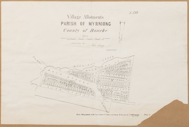 Bacchus Marsh & District Historical Society
Map, Village allotments, Parish of Myrniong, County of Bourke
... A cadastral parish map of Myrniong in Victoria, showing numbered land allotments. Photo-lithographed at the Department of Lands & Survey, Melbourne, in 1903. ...A cadastral parish map of Myrniong in Victoria, showing numbered land allotments. Photo-lithographed at the Department of Lands & Survey, Melbourne, in 1903. ...Myrniong is a village 9 kilometers west of Bacchus Marsh. Prior to 1863 the area was known as Blow's Flat. This map which was produced in 1903 and according to the catalogue record of this map held at the State Library of Victoria was based on an earlier map created in 1861. The early layout of streets for the village of Myrniong can be seen on this map. The streets shown are, Main Street, Hardy Street, Blow Street, Myrniong Street, Shuter Street, and Blackwood Street. An area marked as a reserve for a school can be seen between Hardy Street and Main Street.A single page paper map. A cadastral parish map of Myrniong in Victoria, showing numbered land allotments. Photo-lithographed at the Department of Lands & Survey, Melbourne, in 1903. Based on an original map created in 1861. The map is pasted into a bound volume containing 76 maps or plans in total. High resolution digital image stored on BMDHS computer network. Surveyed by John Hardy, Surveyor ; photo-lithographed at the Department of Lands & Survey, Melbourne by T.F. McGauran, 24.12.03myrniong parish plan, myrniong parish maps -
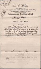 Bendigo Historical Society Inc.
Document - W.D.MASON COLLECTION: CONDITIONS OF SALE, 28 June 1910
... T.C.Watts Auctioneer and Real Estate Agent, Sworn Valuator, Albion Chambers, View Street, Bendigo. Four land allotments were sold in Albion St, off Condon St., on 28.6.1910 for seventy Pounds. ...T.C.Watts Auctioneer and Real Estate Agent, Sworn Valuator, Albion Chambers, View Street, Bendigo. Four land allotments were sold in Albion St, off Condon St., on 28.6.1910 for seventy Pounds. ...Cream Document, W.D.Mason collection, Conditions of Sale, Freehold Land in Albion Street, Bendigo. T.C.Watts Auctioneer and Real Estate Agent, Sworn Valuator, Albion Chambers, View Street, Bendigo. Four land allotments were sold in Albion St, off Condon St., on 28.6.1910 for seventy Pounds. The vendor was Mr John R Daley of Elwood who sold to Owen Williams, Condon St, Bendigo.Cambridge & Young, Printers, Market Square.business, retail, w d mason -
 Bacchus Marsh & District Historical Society
Map, Gaynor Street Land Sales, Maddingley, circa 1880s-1890s
... A single page paper map showing land allotments for sale in the Maddingley area of Bacchus Marsh. ...Bacchus Marsh Victoria Maps Maddingley Victoria Maps Land Use Maddingley Victoria History Land Sales Bacchus Marsh Land Sales Maddingley A single page paper map showing land allotments for sale in the Maddingley area of Bacchus Marsh. ...This map was produced for a major sale of land in the Maddingley area of Bacchus Marsh. The precise date of the sale has not been determined. Features present on the map such as the Bacchus Marsh Railway Station indicate the land sale must have taken place some time after 1887 when the Railway Station opened. A single page paper map showing land allotments for sale in the Maddingley area of Bacchus Marsh. Locations shown include Gaynor Street, Maddingley Road South, Parwan Road, Mitchem Street, Typpynge Street, Finn Street and East Maddingley Road. . The map is pasted into a bound volume containing 76 maps or plans in total. High resolution digital image stored on BMDHS computer network. bacchus marsh victoria maps, maddingley victoria maps, land use, maddingley victoria history, land sales bacchus marsh, land sales maddingley