Showing 64 items matching " linton railway"
-
 Linton and District Historical Society Inc
Photograph, Linton Railway Station and Stationmaster's House
... Linton Railway Station and Stationmaster's House...Linton Railway Station...Black and white photograph of platform and buildings at Linton Railway Station. The stationmaster's house can be seen on the right-hand side of the photograph....Linton and District Historical Society Inc 69 Sussex Street Linton 3360 goldfields Linton Railway Station Buildings Stationmaster's house Linton Black and white photograph of platform and buildings at Linton Railway Station. ...Black and white photograph of platform and buildings at Linton Railway Station. The stationmaster's house can be seen on the right-hand side of the photograph.linton railway station, buildings, stationmaster's house linton -
 Linton and District Historical Society Inc
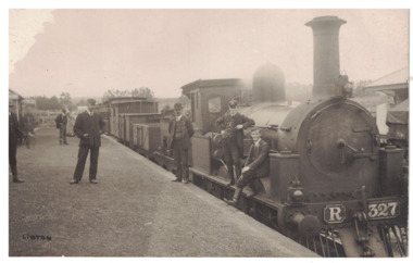
Postcard - Photograph, Steam Train, Linton Railway Station
... Steam Train, Linton Railway Station...linton railway station...Postcard which has a black and white image of a steam engine and carriages at Linton Railway Station. The R class engine was constructed at the Phoenix Foundry, Ballarat, between 1881 and 1886....Steam Train, Linton Railway Station Postcard Photograph ...Postcard which has a black and white image of a steam engine and carriages at Linton Railway Station. The R class engine was constructed at the Phoenix Foundry, Ballarat, between 1881 and 1886.Text, reverse: "Boy sitting on engine is Harold Morgan, man wearing bowler hat standing beside engine thought to be Mr Bourke, engine driver, father of Kitty and Lizzie. White house behind station master's cap, weatherboard cottage occupied by Mrs Howe, her daughter Myra and son Billy. Man on station wearing cap thought to be station master, Alec Thompson's father".linton railway station, steam engines, transport, railways -
 Linton and District Historical Society Inc
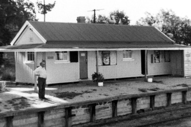
Photograph, Linton Railway Station, circa 1970
... Linton Railway Station, circa 1970...Linton Railway Station...Black and white photograph of Linton Railway Station taken around 1970, showing the ticket office, waiting room, parcel/store shed and toilets. ...Linton and District Historical Society Inc 69 Sussex Street Linton 3360 goldfields Linton Railway Station Black and white photograph of Linton Railway Station taken around 1970, showing the ticket office, waiting room, parcel/store shed and toilets. ...Black and white photograph of Linton Railway Station taken around 1970, showing the ticket office, waiting room, parcel/store shed and toilets. An unidentified man is standing on the platform.linton railway station -
 Linton and District Historical Society Inc
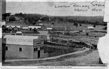
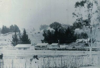
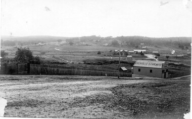
Photograph, Grenville Standard and Linton Railway Station buildings, c.1900
... Grenville Standard and Linton Railway Station buildings, c.1900...... Linton Railway Station...The 'Grenville Standard' was Linton's newspaper from 1895-1941. The railway arrived at Linton in 1891. ...Linton township. 'Grenville Standard' building prominent in foreground, railway buildings and machinery, and station-master's house, in middle ground. ..."Linton Railway station about 1900" hand printed across top of photograph. ...Grenville Standard [newspaper] Linton Railway Station Buildings Station Master's House Linton "Linton Railway station about 1900" hand printed across top of photograph. ...The 'Grenville Standard' was Linton's newspaper from 1895-1941. The railway arrived at Linton in 1891. Black and white postcard photograph of view looking east from Clyde Street in Linton township. 'Grenville Standard' building prominent in foreground, railway buildings and machinery, and station-master's house, in middle ground. Hills rising behind, with two or three cottages, and trees."Linton Railway station about 1900" hand printed across top of photograph. "Looking East from Township of Linton" printed beneath picture.grenville standard [newspaper], linton railway station, buildings, station master's house linton -
 Linton and District Historical Society Inc
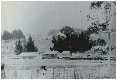
Photograph, Linton Railway Station and Station Master's Residence
... Linton Railway Station and Station Master's Residence...Linton Railway Station...Black and white copy of original photograph which shows the Linton railway station buildings and stationmaster's house in middle-ground to right. ...The photograph was printed from the negative in 2016. Linton Railway Station Linton Station Master's house Houses Buildings Black and white copy of original photograph which shows the Linton railway station buildings and stationmaster's house in middle-ground to right. ...It is not known when the photograph was taken. The photograph was printed from the negative in 2016.Black and white copy of original photograph which shows the Linton railway station buildings and stationmaster's house in middle-ground to right. A picket fence in foreground, and a tree on rhs. View is of Linton from Slaughterhouse Hill.linton railway station, linton station master's house, houses, buildings -
 Linton and District Historical Society Inc
Photograph, O'Beirne's Wool and Skin Business, circa 1900, 1900
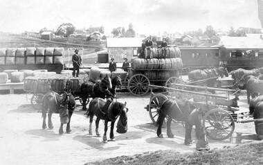
... ... Linton Railway Station...Man standing on bales in front of the 'Linton' railway station sign is identified as F W O'Beirne. ...Original sepia photo of O'Beirne's wool and skin wagons loaded with bales, at Linton railway station. Numerous draught horses in foreground, some with feeding bags....O'Beirne Transport Business enterprises Wool and skin merchants Wool bales Horses Linton Railway Station On back: "Sturgeon-26". Original sepia photo of O'Beirne's wool and skin wagons loaded with bales, at Linton railway station. ...Man standing on bales in front of the 'Linton' railway station sign is identified as F W O'Beirne. No others identified.Original sepia photo of O'Beirne's wool and skin wagons loaded with bales, at Linton railway station. Numerous draught horses in foreground, some with feeding bags.On back: "Sturgeon-26".o'beirne family, f.w. o'beirne, transport, business enterprises, wool and skin merchants, wool bales, horses, linton railway station -
 Linton and District Historical Society Inc
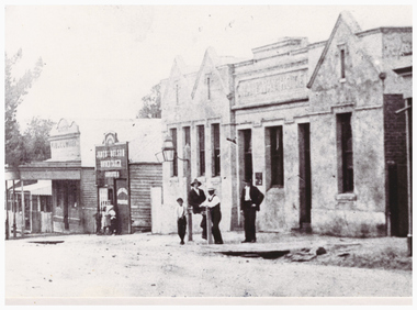
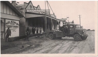
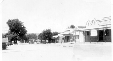
Photograph, Sussex Street, Linton, showing Railway Hotel, James Nelson Undertaker, Linton Public Library, c.1905
... Sussex Street, Linton, showing Railway Hotel, James Nelson Undertaker, Linton Public Library...Linton... Railway Hotel Linton...Sussex Street, Linton, showing Railway Hotel, James Nelson Undertaker, Linton Public Library Photograph ...Photograph dated to between 1903 and 1914. The original wooden buildings of the Railway Hotel were removed in early 1903 and a brick replacement erected that year. James Nelson (who ran the undertaker's business shown next to the hotel) died in 1914 and the business was afterwards run as 'Nelson Bros. Undertakers' by his three sons.This is a cropped version of a photograph (Registration no. 338) which shows both east and west sides of Sussex Street. The photograph has been mounted on card (for use at LDHS exhibition, 1983). sussex street linton, railway hotel linton, james nelson undertaker, linton public library -
 Linton and District Historical Society Inc
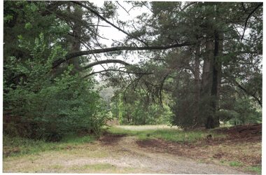
Photograph, Entranceway to former Railway Station, Linton, 2014
... Entranceway to former Railway Station, Linton, 2014...... Linton Railway Station...The path leads from Denison Street to what remains of the railway station and platform at Linton. The photograph was taken by Gary Hunt in 2014....Denison Street Linton Linton Railway Station Colour photograph which shows a pathway between trees. ...The path leads from Denison Street to what remains of the railway station and platform at Linton. The photograph was taken by Gary Hunt in 2014.Colour photograph which shows a pathway between trees.denison street linton, linton railway station -
 Linton and District Historical Society Inc
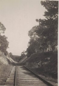
Photograph, Railway Line, Linton
... Railway Line, Linton...Linton railway...Railway Line, Linton Photograph ...Small black and white image of a railway line running through a cutting.linton railway -
 Linton and District Historical Society Inc
Floor plan, Floor plan of Railway Hotel, Linton, 1953
... Floor plan of Railway Hotel, Linton, 1953...Railway Hotel Linton...Architectural drawing showing block and floor plan of Linton's Railway Hotel. The plan appears to have been drawn up for the Ballarat Brewing Company, which owned the hotel, in connection with proposed renovations. ...Linton and District Historical Society Inc 69 Sussex Street Linton 3360 goldfields Railway Hotel Linton Maps and plans Floor plans Architectural drawing showing block and floor plan of Linton's Railway Hotel. ...Architectural drawing showing block and floor plan of Linton's Railway Hotel. The plan appears to have been drawn up for the Ballarat Brewing Company, which owned the hotel, in connection with proposed renovations. Plan is initialled "J. O. O'B." and dated"5.5.53". Plan shows bar area, parlours and dining rooms, residential areas, ablutions areas, staff bedrooms, rooms used for accommodation, and outbuildings (stable, garage etc.).railway hotel linton, maps and plans, floor plans -
 Linton and District Historical Society Inc
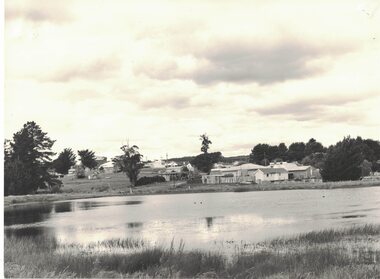
Photograph, View of Linton from across Edinburgh Dam, 1984
... Small white building near Rutherford house was formerly the Linton Railway Station office building....The little / white hut behind Rutherfords / (right foreground) was the / office building from Linton / Railway Station, moved / to this site c. 1981/2"....The little / white hut behind Rutherfords / (right foreground) was the / office building from Linton / Railway Station, moved / to this site c. 1981/2". ...Image taken 1984. House on right in middle-ground belonged to Rutherford family (prior to this it was the police residence; it was moved to this site in the 1960s). Small white building near Rutherford house was formerly the Linton Railway Station office building.Black and white image of a body of water, Edinburgh Dam - in foreground. Houses and shops (along Sussex Street) in background."Linton from across the / Edinburgh Dam. The little / white hut behind Rutherfords / (right foreground) was the / office building from Linton / Railway Station, moved / to this site c. 1981/2".edinburgh dam, rutherford house -
 Linton and District Historical Society Inc
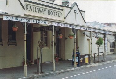
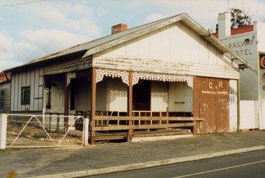
Photograph, Railway Hotel, Sussex Street, Linton, 2014
... Railway Hotel, Sussex Street, Linton, 2014...Railway Hotel Linton...The change to this name occurred after tenders were let to build the railway line to Linton in 1889. The hotel was substantially renovated in the early 1900s and the verandah is thought to have been added by about 1920....The photograph shows Linton's Railway Hotel as it was in 2014....The photograph shows Linton's Railway Hotel as it was in 2014. Railway Hotel, Sussex Street, Linton, 2014 Photograph ...The hotel began life in the 1860s as Luth's Hotel, and was then known as O'Sullivan's Hotel and McCuskey's Hotel before becoming the Railway Hotel in about 1890. The change to this name occurred after tenders were let to build the railway line to Linton in 1889. The hotel was substantially renovated in the early 1900s and the verandah is thought to have been added by about 1920.One of three colour photographs printed on a single sheet of photographic paper. The photograph shows Linton's Railway Hotel as it was in 2014.railway hotel linton -
 Linton and District Historical Society Inc
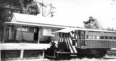
Photograph, The 'Linton Flyer', also known as the 'Beetle', c.1939
... Black and white photograph of a rail motor, standing at Linton Railway Station. The rail motor has distinctive stripes at the front....School train Rail motor Linton Flyer Beetle Black and white photograph of a rail motor, standing at Linton Railway Station. The rail motor has distinctive stripes at the front. ...This rail motor was used between 1930 and 1953 to transport students to school in Ballarat.Black and white photograph of a rail motor, standing at Linton Railway Station. The rail motor has distinctive stripes at the front.school train, rail motor, linton flyer, beetle -
Linton and District Historical Society Inc
Plan, Floor plan of Railway Hotel, Linton, undated
... Floor plan of Railway Hotel, Linton, undated...Railway Hotel Linton...Laminated blueprint, showing 1/8 scale floor and block plan of the Railway Hotel in Sussex Street, Linton. Drawn in white ink on blue paper....Floor plan of Railway Hotel, Linton, undated Plan ...It is not known when the plan was drawn up or by whom.Laminated blueprint, showing 1/8 scale floor and block plan of the Railway Hotel in Sussex Street, Linton. Drawn in white ink on blue paper.railway hotel linton, maps and plans, floor plans -
 Linton and District Historical Society Inc
Photograph, Electricity Connection, Linton, 1939
... Linton...Railway Hotel...Black and white image of SEC pole being erected for electricity connection outside Railway Hotel and Nelson Undertakers, Sussex Street, Linton. Linton was connected to the Victorian electricity grid in September 1939....Linton and District Historical Society Inc 69 Sussex Street Linton 3360 goldfields State Electricity Commission Linton Railway Hotel Black and white image of SEC pole being erected for electricity connection outside Railway Hotel and Nelson Undertakers, Sussex Street, Linton. ...Black and white image of SEC pole being erected for electricity connection outside Railway Hotel and Nelson Undertakers, Sussex Street, Linton. Linton was connected to the Victorian electricity grid in September 1939.state electricity commission, linton, railway hotel -
 Linton and District Historical Society Inc
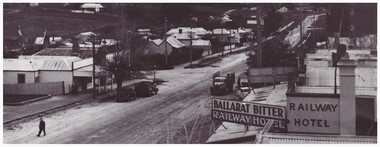
Photograph, Sussex Street, Linton, circa 1940
... Linton... Railway Hotel Linton...Black and white photograph of Sussex Street, Linton. View from above, roof of Railway Hotel on right in foreground, then view of shops and houses along west of street, looking to the north-west....Sussex Street Linton Railway Hotel Linton "Ballarat Bitter" On back of photograph: "Linton - probably c1930s". ...Photograph is understood to have been taken from the Linton Fire Brigade tower in Sussex Street. Date photograph taken is unknown, presence of electricity poles in street suggests it was taken after 1939.Black and white photograph of Sussex Street, Linton. View from above, roof of Railway Hotel on right in foreground, then view of shops and houses along west of street, looking to the north-west.On back of photograph: "Linton - probably c1930s".sussex street linton, railway hotel linton, "ballarat bitter" -
 Linton and District Historical Society Inc
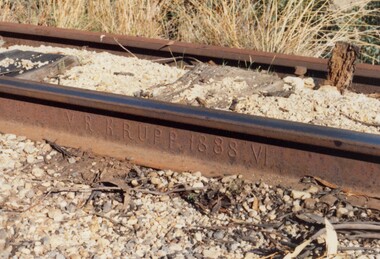
Photograph, Section of Rail Line, Linton circa 1982, 1982
... ... Linton railway...Linton and District Historical Society Inc 69 Sussex Street Linton 3360 goldfields Railway tracks Linton railway Colour photograph showing lengths of metal track. ...Colour photograph showing lengths of metal track. This part of the track is stamped "5-82 VR Krupp 1888 V1".railway tracks, linton railway -
 Linton and District Historical Society Inc
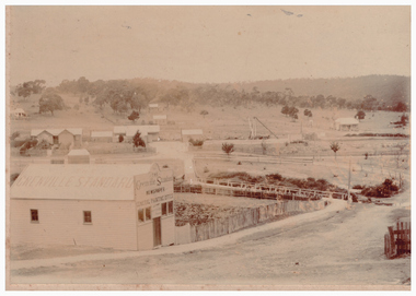
Photograph, Grenville Standard Building, Clyde Street, Linton
... ... Linton Railway Station...Linton and District Historical Society Inc 69 Sussex Street Linton 3360 goldfields Grenville Standard [Newspaper] Buildings Linton Railway Station Clyde Street Linton "S E Surman". ...Sepia photograph of Grenville Standard building, with view of railway station and other buildings spread across open land at east of township."S E Surman".grenville standard [newspaper], buildings, linton railway station, clyde street linton -
 Linton and District Historical Society Inc
Photograph, Sussex Street, Linton - view to north, late 1920s or early 1930s
... Linton... Railway Hotel...Black and white photograph of Linton's main street, Sussex Street. View of Railway Hotel, Nelson undertaker building, public library and "cash emporium". ...Sussex Street Linton Railway Hotel Nelson Undertakers Linton Public Library Cash emporium Transport Cars "Linton Main Street". ...Dated to late 1920s or early 1930s as Nelson building has been renovated as a Californian bungalow. The earlier curvilinear parapet on the library building (see photo - Registration no. 166) has been squared off, and a small pedimented timber parapet has been added above.Black and white photograph of Linton's main street, Sussex Street. View of Railway Hotel, Nelson undertaker building, public library and "cash emporium". Cars parked and driving along Sussex St."Linton Main Street".sussex street linton, railway hotel, nelson undertakers, linton public library, cash emporium, transport, cars -
 Linton and District Historical Society Inc
Photograph, Empire Post Card, Postcard showing the Grenville Standard building, 1909
... ... Linton Railway Station...Linton. As kids we loved to watch as the train came out facing a different way. The railway station master's house Mr Thompson was the SM. ...Grenville Standard [newspaper] Linton Railway Station Buildings Grace Bennett afterwards Grace Wishart Amelia (Millie) Bennett afterwards Millie Allen On postcard: "Linton 30.6.09 [=1909] Dear Mill, you will be surprised at -- postcard and so soon. ...Written on envelope attached: "This was sent to Aunty Mill from Aunty Grace. This photo was taken from our back gate opposite the post office. Miss Magan(?) was PM. The old Grenville Standard office run by Mr Adams. The little houses on the hill behind one was Mr Terrett a tailor who made the band uniforms. Mr Tom Bennett house butcher. The slaughter house is among the trees in the background. Note where the 'Law' is at the post office. I would like to see this enlarged. I think this photo is special because it shows the turntable where the trains used to turn before the rail went thru to Skipton which I remember all the [illegible] being made so many people working in Linton. As kids we loved to watch as the train came out facing a different way. The railway station master's house Mr Thompson was the SM. The old Grenville Standard office run by Mr Adams." Note: "Aunty Mill" = Amelia (Millie) Bennett, afterwards Millie Allen. "Aunty Grace" = Grace Bennett, afterwards Grace Wishart.Black and white postcard of Grenville Standard building with railway station and station master's house in background.On postcard: "Linton 30.6.09 [=1909] Dear Mill, you will be surprised at -- postcard and so soon. I forgot when writing, I wanted to ask you if Percy could get me a few dolls at wholesale price we are to have a bazaar for the church, and want to make something on our purchases. Let me know soon and I will get the money and quantity etc. required. Yours sincerely, Grace".grenville standard [newspaper], linton railway station, buildings, grace bennett afterwards grace wishart, amelia (millie) bennett afterwards millie allen -
 Linton and District Historical Society Inc
Photograph, Former Nelson Bros. Building Before Restoration, 1987, 1987
... Colour photograph of dilapidated single fronted building located beside a brick building (Linton's Railway Hotel). Photograph is of former Nelson Bros. funeral parlour, which after restoration became the LDHS Resource Centre. ...Colour photograph of dilapidated single fronted building located beside a brick building (Linton's Railway Hotel). Photograph is of former Nelson Bros. funeral parlour, which after restoration became the LDHS Resource Centre. ...Colour photograph of dilapidated single fronted building located beside a brick building (Linton's Railway Hotel). Photograph is of former Nelson Bros. funeral parlour, which after restoration became the LDHS Resource Centre. "G & A Blacksmith Engineer" is painted on double doors to right, along with some graffiti."Funeral parlour before restoration".ldhs resource centre, nelson bros. funeral parlour, g & a blacksmith engineer, buildings -
 Linton and District Historical Society Inc
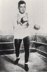
Photograph, Jim Moynihan
... Subject of the photograph is Jim Moynihan, who ran Linton's Railway Hotel in the 1940s and 1950s. Date of the photograph is unknown. ...Linton and District Historical Society Inc 69 Sussex Street Linton 3360 goldfields Subject of the photograph is Jim Moynihan, who ran Linton's Railway Hotel in the 1940s and 1950s. Date of the photograph is unknown. ...Subject of the photograph is Jim Moynihan, who ran Linton's Railway Hotel in the 1940s and 1950s. Date of the photograph is unknown. Early LDHS index to photographs says this is a "Fun Parlor" photograph.Enlarged black and white copy of original photograph which has been mounted on card. The photograph shows a man wearing boxing gloves, shorts etc., who appears to be taking part in a boxing match.jim moynihan -
![Photograph, Sussex Street, Linton - east side, Library to Bennett's Garage, including weighbridge, undated [1930s?]](/media/collectors/5d8bf68021ea67123cb0cc12/items/68ce1a0aa33a5972d3391949/item-media/68ce1c23a33a5972d3395d43/item-fit-380x285.jpg?cb=6) Linton and District Historical Society Inc
Linton and District Historical Society IncPhotograph, Sussex Street, Linton - east side, Library to Bennett's Garage, including weighbridge, undated [1930s?]
... ...Linton Public Library...Railway...East side Sussex Street Linton Linton Public Library Railway Hotel Murrell's Newsagency Linton Weighbridge Bennett's Garage Black and white copy of original photograph, showing east side of Sussex Street between public library building and Bennett's Garage. ...Photograph is thought to have been taken after 1932, as it depicts Bennett's Garage, built 1928, and also Murrell's Newsagency, which moved into premises on the east side of Sussex Street in 1932.Black and white copy of original photograph, showing east side of Sussex Street between public library building and Bennett's Garage.east side sussex street linton, linton public library, railway hotel, murrell's newsagency, linton weighbridge, bennett's garage -
 Linton and District Historical Society Inc
Photograph, Sussex Street, Linton, undated, probably late 1920s or early 1930s
... ...Linton Town Hall...Railway...Allan Ernest Ball Oscar Ball Houses Shops LInton Shire Hall Linton Town Hall Railway Hotel Black and white copy of original photograph which has been mounted on blue card. ...Buildings shown on west side of Sussex Street: Criterion House, at the time occupied by Murrell's Newsagency, the Grenville Shire civic hall and offices, the shop at one time occupied by J. Y. Clarke, barber & tobacconist. The roof of Barr's shop and dwelling can be seen (the building itself is obscured by a tree), and houses further along the street owned by J.G. Allan, Ernest Ball and Oscar Ball. The Royal Standard Hotel appears to have been demolished. On the east side of the street, the roof and signage of the Railway Hotel is visible, and the roof of Cornish's shoe shop. The photograph is undated but was probably taken in between the late 1920s (when the Royal Standard Hotel was demolished) and 1932, when the Murrell family moved its newsagency into the building on the other side of the street previously occupied by Dan Cornish. Note: a gap between the Shire Hall and the next building suggests that the shop and dwelling originally occupied by the Austin family has been demolished.Black and white copy of original photograph which has been mounted on blue card. Photograph shows shops and houses in Sussex Street, Linton, and appears to have been taken from a high vantage point, possibly the fire tower which was located in Sussex Street. View is to north-west of the township.criterion house, murrell's newsagency, j. y. clarke, j.g. allan, ernest ball, oscar ball, houses, shops, linton shire hall, linton town hall, railway hotel -
 Linton and District Historical Society Inc
Musical instrument mouthpiece, Mouthpiece for Brass Musical Instrument
... This mouthpiece was found by Warren Bowen in 2017, in the vicinity of the former Linton Railway Station....This mouthpiece was found by Warren Bowen in 2017, in the vicinity of the former Linton Railway Station. Brass instruments Musical instruments Besson & Co. ...Gustave Auguste Besson and his family manufactured brass musical instruments in France from 1837 and in England from 1857. In England the instruments were stamped "Besson & Co" between 1895 and 1904. The word ‘Prototype’ was stamped on all Besson instruments manufactured after 1885-86 and referred to the method of manufacture. This mouthpiece was found by Warren Bowen in 2017, in the vicinity of the former Linton Railway Station.Metal mouthpiece for a brass musical instrument, probably a cornet or trumpet. Consists of a "U"-shaped cup attached to a tapering shank. "BESSON & Co" and "Prototype" stamped on the shank.brass instruments, musical instruments, besson & co. -
 Linton and District Historical Society Inc
Photograph, Rose, Alfred and Bert Dawe as children
... John initially worked as a miner and later he and Sylvia ran one or more shops (one was in Denison Street near the entrance to the Linton railway station). Printed from glass plate negatives found after death of the donor's uncle. ...John initially worked as a miner and later he and Sylvia ran one or more shops (one was in Denison Street near the entrance to the Linton railway station). Printed from glass plate negatives found after death of the donor's uncle. ...Alfred, Albert and Rose were the children of John Dawe and his wife Sylvia, née Garner. John initially worked as a miner and later he and Sylvia ran one or more shops (one was in Denison Street near the entrance to the Linton railway station). Printed from glass plate negatives found after death of the donor's uncle. Believed to be from collection of Augustus Titter (husband or son of Rose Dawe).Black and white photograph of Rose, Alfred and Bert Dawe in fancy dress, standing on garden seat, c.1901.rose dawe, albert (bert) dawe, 'possum' dawe, alfred dawe -
 Linton and District Historical Society Inc
Photograph, C Gribble 221 Inkerman St, St Kilda, The Graham children
... ... Railway Hotel Linton...Photograph believed to have been taken at rear of Railway Hotel, Linton. The children's parents, John Burt Graham and Catherine Graham, were licensees of the hotel from about 1889. ...Linton and District Historical Society Inc 69 Sussex Street Linton 3360 goldfields Photograph believed to have been taken at rear of Railway Hotel, Linton. ...Photograph believed to have been taken at rear of Railway Hotel, Linton. The children's parents, John Burt Graham and Catherine Graham, were licensees of the hotel from about 1889. (J B Graham died in 1896, and his wife continued to manage the hotel until about 1901.)Sepia photograph of two girls and a young boy, one girl seated holding a book on her lap, the other girl standing beside the chair, and the young boy standing on the chair between the two girls one hand on each of girls shoulders."Graham family Linton, Bert Graham musician".gertie graham, nellie graham, bert graham, railway hotel linton -
 Ballarat Heritage Services
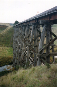
Photograph - Photograph - Colour, Clare Gervasoni, Nimon's Bridge, 1999, 04/10/1999
... Nimons Bridge was built in 1890, as part of the then Ballarat-Linton railway. The bridge is 17 spans with tall timber piers of four driven piles each, with triple sets of diagonal cross-bracing and walers and a single row of longitudinal horizontal bracing between piers. ...Ballarat Heritage Services PO Box 2209 Bakery Hill Post Office goldfields Nimons Bridge was built in 1890, as part of the then Ballarat-Linton railway. The bridge is 17 spans with tall timber piers of four driven piles each, with triple sets of diagonal cross-bracing and walers and a single row of longitudinal horizontal bracing between piers. ...Nimons Bridge was built in 1890, as part of the then Ballarat-Linton railway. The bridge is 17 spans with tall timber piers of four driven piles each, with triple sets of diagonal cross-bracing and walers and a single row of longitudinal horizontal bracing between piers. The spans are of a uniform twenty feet (6.1 metres), originally supported by four 21-inch x 9-inch (535 mm x 230 mm) Kauri timber beams per span, following the standard V.R. design of the period. When the superstructure was rebuilt after the 1953 fire, the timber beams were replaced with two 24-inch (610mm) deep rolled-steel-joists on each span. These are marked 'Lancashire Steel Co., Scotland' and are believed to have been second-hand. The deck of transverse-timber planks is 103.6 metres in length. Overall the bridge has an impressive appearance with its exceptionally tall triple-cross-braced piers creating a 'three-tiered' effect, with the deck 19.2 metres above the Woady Yaloak River. The Ballarat-Skipton line closed in 1985. Nimons Bridge has been recently restored, as part of the Ballarat-Skipton Rail Trail. How is it significant? Nimons Bridge is significant for technical, historic and aesthetic reasons at a State level. Why is it significant? Nimons Bridge is technically significant as Victoria's fourth-tallest timber trestle bridge when built, and as the third-tallest surviving example. It is also the second-largest composite bridge combining traditional timber piers with RSJ spans and a timber deck and falls within a select group of fewer than ten timber railway bridges with horizontal longitudinal bracing between the piers and three sets of double cross-bracing on its tallest piers, creating a visually striking 'three tiered' effect that enhances its viaduct form. Nimons Bridge is historically significant as having served initially the mining community at Linton, then the Western District agricultural area and in later years a kaolin quarry at Pittong. Nimons Bridge is historically significant as a representative of the 'light' branch line methodology that stimulated the explosion of railway construction in Victoria during the 1880s, and provides an interesting contrast with the more solid and vastly more expensive railway viaducts built in similar terrain on Victorian main lines, at Moorabool and Taradale, in the late 1850s. Approached by a deep cutting and high embankment at either end, the bridge represents a very cost-effective late 19th century engineering solution to the characteristic physiography of western Victoria with flat basalt plains intersected by deep wide valleys occasionally subject to severe flooding. Nimons Bridge is aesthetically significant for its visually impressive viaduct form, crossing a deep and steep-sided valley that is part of a rich cultural landscape. Within close proximity of the bridge are mullock dumps, tailings, shaft sites and other relics of the deep-lead alluvial mining era. The bridge is the most visually spectacular timber-trestle rail bridge in Western Victoria and is among the most spectacular timber-trestle rail bridges surviving anywhere in Victoria. It is part of the Ballarat-Skipton Rail Trail. Classified by the National Trust :02/10/2000 (http://vhd.heritagecouncil.vic.gov.au/places/67986)Colour photograph of a log bridge known as Nimon's Bridge.ballarat-linton, nimons bridge, nimon's bridge, log bridge, viaduct, timber-trestle rail bridge -
Federation University Historical Collection
Document, Zelda Martin, Central Victorian Goldmining towns - Boom Towns or Ghost Towns?, c1996
... Zelda Martin Victorian goldfield towns bendigo castlemaine ballarat Maldon Stawell Ararat maryborough Creswick Avoca Heathcote Banks Bank of Australasia Union bank of Australia government camp Sandhurst water supply Tarnagulla Talbot back creek Mountain Creek Police court Carisbrook dunolly thompson's foundry Charles Clacy Anthony Trollope Robert Cecil Mount Alexander urbanisation national schools education govenrment industry railway transport settlement land settlement in central Victoria Steiglitz Joseph Brady The New Australian Mine Berry Deep Leads William Guthrie Spence Creswick State Forest Arthur Worsley Worsley Cottage The Welcome Stranger Moliagul Moonambel Redbank St Arnaud Sebastapol Brown's Scarsdale Clunes Chewton Daylesford Bushfires Inkerman Inglewood Kingower Lintons Happy Valley Piggoreet McIvor Majorca Tarrangower Taradale The Coliban System The Syphon Sandy Creek Wedderburn Koorong Arnold Jones Creek Waanyarra The Golden Triangle Census 1857 Blackwood Buninyong Durham Lead Magpie Carngham Snake Valley Alma Amherst Daisy Hill Amphitheatre Mountain Hut Beaufort Fiery Creek Counties population gold fields commission of enquiry1854 William Westgarth Gold license Fee lieutenant Colonel Valiant administration of the victorian gold fields Commission to Enquire into Sludge 1859 E.S. ...Zelda Martin was a PhD candidate at the University of Melbourne.[.1] 4th item in light blue display book titled Research Approach/Overview of Chapters/Confirmation of Canditure/Chapters1,2,3&4 of proposed thesis. *Twenty-seven page article on Victorian goldfields towns titled: Central Victorian Goldmining Towns - Boom Towns or Ghost Towns. The article was written during the author's PhD study. It outlines the context methodology, and resources and the chapters of the proposed thesis: (1) Central Victorian Goldmining Towns - The Context (2) Contemporary Views of the Factors Necessary for Town Growth (3) Outward Manifestations of Town Growth (4) The Trappings of Government (5-9) The Main Towns and Their Hinterland. [.2] 5th item in Light Blue display book as above item. *Chapter 1 of proposed thesis titled 'Pick, Shovel and Tin Dish Mining.' Covers in Section A: Central Victoria - Pre 1851: Aborigines in Central Victoria, Squatters, and Government. Section B: The years 1851-1854: The Early Gold Rushes, Government Reaction, Township Surveys, Legislation, Town Development, Local Government and Early Settlement. [.3] 6th item in Light Blue display book as above item. *2A of proposed thesis titled 'Contemporary Views of the Factors Necessary for Town Growth'. Similar information to Chapter 1 plus extra re towns and maps. Sections: Introduction, Context of Place - Geographical Towns Listed, The Context of Time - Pre1851 Aborigines, Governance of Port Phillip, The Squatters, The Villages of Central Victorian Highlands, Conclusion, Condensed Version of Chapter2B. [.4] 7th item in Light Blue display book as above item. *Chapter2B of proposed thesis. Sections: Area of Research, Schools, Banks, Newspapers, Progress Association, Town Development - Sandhurst (Bendigo), Ballarat, Castlemaine,, Maryborough, Ararat and Stawell. [.5] 8th item in Light Blue display book as above item. *Chapter 3 of proposed thesis titled 'Outward Manifestations of Town Growth'. Sections: Introduction, Contemporary Writing, Educationalists, The Bankers, The Townsfolk, Current Theory, General Theories of Urban Development, and Conclusion. [.6] 9th item in Light Blue display book as above item. *Chapter 4 of proposed thesis titled 'Trappings of Government' Sections: Introduction, Early Government Attitudes to Mining and Town Development, Law and Order, Township Surveys, Legislation, Local Government, Transport and Communication, The People and Lobbyists. [.7] 10th item in Light Blue display book as above item. *'The Rise and Fall of Central Victorian Goldmining Towns'. Includes a map showing main Goldfields, a table showing towns and villages at two points in time - 1857 and 1871; a Bibliography of Primary and Secondary Sources. [.8] Resource No1. Black display book titled Local Towns 1 : Alma: *Brief history *Directory *Maps Amphitheatre / Mountain Hut: *Brief History Post Office Directory Ararat: *Brief History *Post Office Directory 1869 - Alphabetical Listing by Occupation *Ararat - Prominent Citizens of 1858 *Langi-Morgala Museum Avoca: *Brief History *Excerpts from 'Avoca The Early Years', Margery and Betty Beavis; pg1 - Beginnings; pg11 - The Midas Touch; pg25 - Local Gold Escorts; pg27 - A Town is Born; pg51- The Administration of Justice; pg53 - The Ways of the Law; pg61 - News of the Day; pg65 - A Time to Play; pg72 - Land Ownership *Post Office Directory (Bailliere's) 1869 *Tourism Map and Information of area *Historic Avoca - A 5.5km Tour *Avoca & the Pyrenees Region - information pamphlet Ballarat: *Early History of Ballarat - Ballarat Historical Society, Publication No.1: origin of the name; Ballaarat - the Beginning; Fabulous Yields from the Ballaarat Goldfield; *Streetscape Lydiard Street. *Hand drawn map showing Leigh River, Old Portland Bay Road, plaque on road to Colac; etc. *Newspaper article re 'The Theatre Royal' ( which stood in the vicinity of the current Owen Williams store) - 'The News'15/04/1998 *Article - 'Ballarat's Mechanics' Institute Lives On' Ballarat Courier, 14/09/1985 *Article - Standing the Test of Time' The News 17/11/1993 re The Mechanics Institute & picture of the Reading Room *'Ballarat a Study of a City, Phyllis Reichl, pub. Nelson, 1968; no.3 place, time and people field studies series *Investigator Vol.33 No.2, 1998 Geelong Historical Society. Article on pg75 describes Ballarat in 1861 *Folded poster - 'Ballarat 100' a history of telegraph communication, pub. Telecom. Beaufort (Fiery Creek): *Brief history *Post Office Directory [.9] Resource No.2 Black Folder Titled Towns cont.No2 Bendigo (Sandhurst): *'Family & Local History at the Bendigo Library - 1851-2001 150 years of gold'. *Bendigo Government Camp in 1853 illustration; key to sketch and names of Government officers stationed there *Excerpts from 'Bendigo and Vicinity' Adolph Haman *The Bendigo Goldfield Registry - pgs 1-7 Introduction *Excerpt: 'Breaking the Grip' *Excerpt: The Most Go-Ahead Place *Excerpts from 'History of Bendigo' - anti license agitation; laying out of town; proposed railway; gold calls and dividends; the Sandhurst Municipality; journalism *Bibliography Blackwood: *Excerpts from 'Aspects of Early Blackwood - The Goldfield, the Landmarks, the Pioneers' Alan J Buckingham and Margaret F Hitchcock, JG Publishing,1980 Buninyong: *A Brief History *Investigator Vol1 No.2 Feb 1966 Geelong Historical Society. Pg3 - Article re gold escort route - Mt Alexander to Adelaide - (see a simple monument on the Western Highway a few miles out of Horsham. Pg 15 - Ballarat Excursion - re the finding of gold. *Three articles published by Buninyong and District Historical Society Inc: (Magpie Exploration; Finding Gold In The Green Hills; Magpie Exploration; Burnt Bridge to Cargarie to Mt Mercer) *Copies of newspaper articles/items *Buninyong Street Directory Carisbrook: *In the Beginning There Was Carisbrook *The History of the Carisbrook Racecourse Carngham / Snake Valley: *Brief History *Directory Castlemaine: *Directory 1865-1866 - Alphabetical and Street *Poster - Castlemaine A Contemporary Guide "The Great Centre" 1866 - A Contemporary Guide to the Fascinating Past *Pamphlet - Castlemaine District Community Hospital *Map - Castlemaine, Maldon & Surrounding Districts *Map and Information - The Dry Diggings Track - a 55kl walk among historic goldfields relics ( Castlemaine Fryerstown Vaughan Mt Franklin Hepburn Daylesford) *Postcard - Former Court House *Directory 1867 - Alphabetical, Trade [.10] Resource No.3 Grey folder Titled Towns 3 Creswick to Maryborough Creswick: *Brief History *Booklet - "Creswick Cemetery Walk" *Booklet - The Buried Rivers of Gold Heritage Trail Creswick *Creswick Historical Museum Information Sheet *Chronological History of Creswick *Alphabetical Directory of the Borough of Creswick *Creswick's Creek Directory 1856 *Historic Creswick Walking Tour *A Brief Account of the Schools of Creswick - Past and Present *100 Years of Railway Travel in Creswick *The Berry Deep Leads *The Spence Home at Jackass Gully in the Creswick State Forest ( William Guthrie Spence - Pioneer) *The New Australian Mine and the 1882 Disaster *Creswick District News, Issue 7, July August 1999 *The Creswick Miners Walk - Information and Map *Maps Chewton: *Brief History *Directory Clunes: *Brief History *Clunes Street Directory Daylesford: *Brief History *Notable Bushfires in Daylesford District Over More Than a Century - "Black Thursday" 1851; 1862; 1899; the Disastrous Hepburn Fire of 1906; 1939; 1944; 1969. *Post Office Directory -Daylesford and Hepburn Dunolly / Inkerman: *Brief History *Directory *Pamphlet - Goldfields Historical Museum *Pamphlet - Historic Dunolly - Victoria's Best Kept Secret *Map of Gold Workings at Dunolly Area - showing where the main gold rushes occurred *Brief History - Inglewood *Directory - Inglewood - Name Occupation, Dwelling Kingower: *Brief History *Directory - Name / Ocupation / Dwelling Linton / Happy Valley / Piggoreet: *Brief History *Directory - Lintons McIvor: *"A History of the Shire and the Township of Heathcote" by J.O. Randell Majorca: *Brief History *Official Post Office Directory 1869 - Name / Occupation/ Address Maldon (Tarrangower): *Brief History Part 1 *Brief History Part 2 *Post Office Directory *List - Alphabetical Order by Names plus Business and Trade (Tarrangower Times Oct/1858) *List - Alphabetical Order by Trade plus Name and Business *Directory - Name / Occupation / Dwelling Maryborough: *Worsley Cottage - built by Arthur Worsley, a contractor in stonework in 1894 [.11] Resource No. 4 Blue Display Book titled Towns 4 Moliagul to Stawell Moliagul: *Brief History *Moligul Legislative Assembly (Voting?) List - Names and Occupations *Moliagul Victorian Post Office Directory 1868 - Name / Ocupation / Address / Comments *"The Welcome Stranger" gold nugget *The Sunday School *The Welcome Stranger Discovery Walk - information and map Moonambel (Mountain Creek) Redbank *Brief History *List of names extracted from advertisments of the Pioneer and Mountain Creek Advertiser 16/02/1861. *Bailliere's Directory 1869 - Alphabetical List of Name / Occupation / Place St Arnaud: *Brief History Sebastapol: *Brief History *Directory 1869 - Alphabetical by Name; plus occupation and address. Browns and Scarsdale: *Brief History *Browns Street Directory - Name and Occupation Smythesdale: *Brief Description *Smythesdale Street Directory -Name and Occupation Stawell (Pleasant Creek) *Brief History *Victorian Official Post Office Directory - Name /Occupation / Dwelling *Chronology - 1841-1920 *Production of gold statistics - 1879 - 1900 *Big Hill *Extracts from "The Golden Years of Stawell". Chapt 1 - Stawell's Coming Out. Capt. 2 - The Gold Rush. Caapt.3 - Cradle of Democracy. Chapt.4 - The Reefs Becomes Stawell. Chapt. 5 - Rushing In. Chapt.6 - The Pioneers. Chapt 7 - The Decade of Optimism. [.12] Resource No. 5: Blue Display Book titled 'Towns Steiglitz to the The Golden Triangle. Steiglitz: Brief History Victorian Post Office Directory 1869 *Map of Steiglitz *List of maps relevant to Steiglitz history *Information 6 tables of data from "Reports of Mining Surveyors Talbot (Back Creek) Brief History Taradale: Post office Directory 1869 - Name/Occupation/Street. Also list in alphabetical order by Occupation Taradale *Chronological Reference to Taradale Mines *Water - The Coliban System of Waterworks *Joseph Brady *The Syphon Tarnagulla (Sandy Creek) *Brief History *Tarnagulla Businessmen Cameos to give depth to advertisments in 'The Tarnagulla Courier' various issues 1864-1871 *Directory - Name/Occupation /Address *List - Name/Business/Trade Wedderburn (Koorong) *Brief History *List - Name/Occupation The Golden Triangle: *The Early Rushes - Wedderburn / Moliagul / Sandy Creek - Tarnagulla / Jones Creek - Waanyarra / Kingower / Dunolly - Goldsborough / Inglweood *Census of 1857 - Population / Occupations *1858-1871 - A Time of Consolidation- Wedderburn / Moliagul / Sandy Creek- Tarnagulla / Arnold *Census 1871 - Population *Information gleaned from the census data - Demographics / Population / Occupations / marital / Birthplace / Religion / Literacy/ Occupation and Housing Cameos *Graphs - Birthplace of settlers /Male-Female Ratio / Married males / Children under 15 as Percentage of Population / Religion *Census 1857 - Statistical data *Maps *Bibliography [.13] Resource No. 6 - Black Display Book Information and Research in Central Victoria including: *Banking - Research from ANZ Bank Archives *Institutions - also includes articles listed from the Ballarat Times Newspaper *Australian mining History Association - A.M.H.A. Bibliography *Australia's Mining History * Bibliography - Land Surveys Victoria - *1853 Administration (Statistics and Other) includes: schools / ministers of religion / police / military / local administration / licences for sale of spirits / distances between various Victorian gold fields. * Victoria Government Gazette (Copy) - N0. 116, 12/12/1854 includes: Gold Felds Commission of Enquiry & No. 85, 15/09/1854 - Addresses presented to the Lieutenant Governor (Sir Charles Hotham) during his tour through the Gold Fields of Victoria,1854. Addresses on behalf of : the people of Bendigo; Members of the Church of England, Bendigo; Members of the Wesleyan Church on the Bendigo Gold Fields; Bendigo Gold District General Hospital; the Bendigo Prospecting Association; Committee of the Bendigo Local Exhibition; Bendigo District Medical Association; Coloured Americans Resident at Bendigo; German Inhabitants of Bendigo; Landowners, Inhabitants, and Miners of Castlemaine; Inhabitants of Forest Creek; Inhabitants of Heathcote and Gold Miners of McIvor; Residents and landholders of the District of Bacchus Marsh; Inhabitants of Kilmore and Vicinity. *Gold Fields Correspondence 1853: letter from Lieutenant Colonel Valiant, (Officer commanding the Troops in Victoria) to the Lieutenant Governor re threatened disturbance at Sandhurst (Bendigo) regarding the Gold License Fee. * Extracts from a book "Victoria" re Gold Fields Commission of Enquiry involving mainly Ballarat and Castlemaine and a chapter titled 'A Tour to the Victorian Gold-Fields' *Lists of central Victorian newspapers - listed by date published 1851to 1874; by first date available to State Library. *A list of cities and towns showing County, population in 1861 &1871, and municipal status. [.14] Resource no.7. Black display book. *Reference: Papers presented to Parliament Victoria - 1859-1860 4 volumes - relevant sections copied. Contains information on Branches of Government. General / Finance / Gold / Gazette / Commission and Warrant / Statistic. *Gold Fields Act. In accordance with the Act the gold fields are divided into six districts - Ballaarat, Castlemaine , Sandhurst, Avoca, Ararat, and Beechworth.. Official staff in each gold district consists of a Resident Warden, Wardens, Wardens' Clerks, Bailiffs, Chinese Protectors, Chinese Interpreters, and Mining Surveyors. *Gold Receiver *Gaols *Police magistrates and Clerks of Petty Sessions, etc. *Field Branch *Immigration and Emigration Overland - Chinese - 1859 *Population on the Goldfields *The Geological Survey - The Government Geologist is assisited by staff from four branches - the office Branch; the Publishing Branch; the Field Branch and the Museum Branch. *Commission to Enquire Into Sludge dated 10/02/1859 (Some sections copied) - Report to the Honorable Chief Commissioner of Public Works, Melbourne re the mode of carrying the sludge from the puddling mills in Sandhurst without interfering with the drainage of the town and the roads in the neighbourhood. [.15] Resource No.8: Camel display book titled Resource No. 8. Aborigines *Lists of book titles - +"Readings in Victorian prehistory" +"The Aborigines of Port Phillip" +Aboriginal languages and clans" +"A History of the Port Phillip District" +"Langi Ghiran 1: Aboriginal Rock...." +"Koorie History: sources for aboriginal studies in the State Library of Victoria", ed. Tom Griffiths, Melb. Friends of the State Library, 1989 +"The Public Lands of Australia Felix"; settlement and land appraisal in Victoria1834-91 with special reference to the Western Plains", J.M.Powell, Melb. Oxford University Press 1970 +*Bibliography of the Victorian Aborigines' from the earliest manuscripts to 31st December 1970, Massoa, Aldo, Melb. Hawthorn Press, 1971 +"Aborigines in Colonial Victoria, 1836-1886", M.F. Christie, Sydney University Press, 1979 +"Urban and Industrial Australia: readings in Human Geography" ed J.M. Powell, Melb. Sorrett Pub. 1974 *Extracts: -Processes of Pioneer Settlement - The Squatting Occupation of Victoria, 1834-60. J.M. Powell -Areal Variations in the Class Structure of the Central-Place Hierarchy. P. Scott - Volume1 and Volume 2: Notes Relating to the Habits of the Natives of Other Parts of Australia and Tasmania. Compiled from various sources for the Government of Victoria by R Brough Smyth. John Curry, O'Neil, Melb. 1st pub. Melb. 1876. p31-45 - Numbers and Distribution of the Aborigines in Victoria -Victorian Aborigines 1835-1901 - A Resource Guide to the Holdings of the Public Record Office, Victoria; published by the Government Information Centre 1984. *History of the Aboriginal Artefacts Displayed in the Daylesford Museum. F. G. Powell (4 page pamphlet) *Letter to Zelda Martin from Peter Lovett, Cultural Officer, Ballarat & District Aboriginal Co- Operative, 05/02/1997 *Map: Ian Clarke Victorian Tribunal Boundary Map - Clans of Central Victoria. *Victorian Rock Art and Mythology - Article about Mount Langhi Ghiran and myths of the Tjapwarong people. *Two Aboriginal myths relating to the Grampians - 'The Monster Emu' / 'The Aquisition of Fire', by the Aborigines in the Grampians Areas *Article titled (chapter 8) Ballarat - information re camping sites in the region. Lake Wendouree / Lake Burrumbeet (includes a myth) / Mt Bunninyong / Lal Lal / Pitfield / Mount Elephant / Mount Egerton / Meredith / Lake Goldsmith / Lake Learmonth / Ercildoune *Notes on the Aborigines of the Wider Ballarat Region plus European names=Aboriginal names. John Morris 26/07/1995 *Role of Aborigines in Town Development in Central Victoria. Mentions Native Police Force est. in Port Phillip 1842 and Central Board for Aborigines est. 1860 *The Grave of King Billy. (Frank Wilson) Pamphlet. *Camping Places in Central and Northern Victoria. Article re Lake Burrumbeet site. *Programme for the Unveiling of Memorial Cairn for Edward Stone Parker 1802-1865. Note portrait not accurate. Accurate portrait is available in the book "A Successful Failure A Trilogy The Aborigines and Early Settlers", Edgar Morrison, Graffiti Publications, 2002. * Large envelope addressed to Mr G Netherway containing newspaper cuttings regarding the life of Edward Stone Parker, the unveiling of the Memorial Cairn as mentioned above, articles titled 'Episodes from Our Early Days' (Edgar Morrison, Yandoit)- The Black's School, A School At Last and The Final years. Also a typed page titled 'Historical Background to E.S.Parker's Career. Includes an interesting tale titled 'When the cat lay doggo' re laying power leads for the unveiling ceremony at the memorial site. [.16] green display folder titled 'Research Aids' *List of references to Commissioners' & W'ardens' Reports (formerly held at La Trobe Library Archives, now at Public Records Office [PRO]). Indicates town referred to / date of report / name of camp if different to town. * Archive information re Anglican Records *Movement around the Goldfields - Miners and Storekeepers - usefulness of newspapers in providing information - areas covered - Castlemaine, Maldon, Ararat, Stawell, Tarnagulla, Dunolly. *Port Phillip /Victoria Directories 1839/1867 - Chronological list of Directories included in this series. *"Notes on the History of Local Government in Victoria" A.W. Greig Melb. University Press 1925 - Photo-copied extract p5-p40. (Source - Deakin University Library) - Introduction by W.Harrison Moore. Section 1 - Development in New South Wales Before Separation. Section 2 - Development in Victoria After Its Separation from New South Wales. Hand written notations: 'roads, markets, and local government 1855 on' ;'opportunity of squatters in parliament' and 'opportunities of matters in parliament p33' * Notes on the Establishment of Surveyor General's Department 1851and Commissioner of Crown Lands and Survey. * Newspaper articles from The Argus, 1849, re the discovery of gold in the Pyrenees region. * Excerpt - a report on schools - A.B.Orlebar, Inspector; re the need for permanent school buildings rather than tents. *Excerpt from - 'Approaches to Urban History', Sean Glynn: The Case for Caution * Except from - 'The Urban Sprinkle', Weston Bate: Country Towns and Australian Regional History *Reference- 'The History of Land Tenure in the Colony of Victoria', John Quick. References the Haines Land Bill, land tenure and Land Leagues. [.17] Light blue envelope folder titled 'Birtchnell's Ballarat, etc. Directory 1862 *Contains various directories for Smythesdale, Buninyong, Clunes, Brown's and Creswick. [.18] Red envelope folder no.2 titled Victorian Gazetteer *Selected pages from 1869 Victorian Gazetteer on A4 paper (with a handwritten note questioning if some pages are from 1868 Victorian Gazetteer as appears to be different sizes - A3 pages.) Information includes locations and descriptions of towns, hotels, banks, communications and populations. (Does not include names, residences and occupations) [.19] Red Envelope folder titled Bailliere's Official Post Office Directory 1868 (or1869 or a mixture of both?) *Preface *Contains a selection of pages of towns highlighted in yellow in the the index *Work on this directory was commenced in 1867. *Information includes: Municipalities - mayors and councilors; lists of towns naming male inhabitants and their occupations. [.20]Yellow manila folder titled Post Grad Seminar Presentation 1996 *Gives some background to Zelda Martin's proposed thesis and why she chose the topic Gold Mining Towns Boom or Bust [.21] A3 display book - No. 1A * A list of 'Relevant Newspapers collected: The Tarrangower Times and Maldon Advertiser (first published 1858) Includes dates 1858-1867. The Mount Alexander Mail. Includes dates 1854-1866 The Tarnagulla Courier. Includes dates from1864-1871 Dunolly and Burnt Creek Express. Includes dates from 1862-1871 * Selection of newspaper pages from The Mount Alexander Mail 1854 to 1856, mostly showing advertisements for businesses and services provided to that community. [.22] A3 display book - No. 1B * Selection of newspaper pages from The Mount Alexander Mail 1857 to 1866, mostly showing advertisements for businesses and services provided to that community. [.23] A3 display book -No. 2 * Selection of newspaper pages from The Tarnagulla Courier 1864 to 1871, mostly showing advertisements for businesses and services provided to that community. [.24] A3 display book - No. 3 *Selection of newspaper pages from The Tarrangower Times (and Maldon and Newstead) Advertiser 1858 to1867, mostly showing advertisements for businesses and services provided to that community. [.25] A3 display book - No.4 * Selection of newspaper pages from The Dunolly and Burnt Creek Express; and The Dunolly and Betbetshire Express 1862 to 1871, mostly showing advertisements for businesses and services provided for that community. [.26] A3 display book - No.5 Includes: * Bryce Ross's Diggings Directory. Includes instructions for using this directory. This directory was used by "all persons having connexion or desiring to communicate with 'working parties, private friends, or Stores at the Diggings." As a directory for each area wwas completed it was published in each month's issue of Bonwick's "Digger's Magazine." Years c1852/1853. This Directory commences first at the head of Forest Creek. Includes a directory for Bendigo and Ballarat. Of interest at the end of the Bendigo and Ballarat directory is a list of the number of storekeepers, butchers, doctors, smiths, eating houses, lemonade sellers and chapels. * The Castlemaine Directory and Book of General Information Comprehending Glass's Model Calendar for the Two Years 1862 and1863. "zelda martin, victorian goldfield towns, bendigo, castlemaine, ballarat, maldon, stawell, ararat, maryborough, creswick, avoca, heathcote, banks, bank of australasia, union bank of australia, government camp, sandhurst, water supply, tarnagulla, talbot, back creek, mountain creek, police court, carisbrook, dunolly, thompson's foundry, charles clacy, anthony trollope, robert cecil, mount alexander, urbanisation, national schools, education, govenrment, industry, railway, transport, settlement, land settlement in central victoria, steiglitz, joseph brady, the new australian mine, berry deep leads, william guthrie spence, creswick state forest, arthur worsley, worsley cottage, the welcome stranger, moliagul, moonambel, redbank, st arnaud, sebastapol, brown's, scarsdale, clunes, chewton, daylesford, bushfires, inkerman, inglewood, kingower, lintons, happy valley, piggoreet, mcivor, majorca, tarrangower, taradale, the coliban system, the syphon, sandy creek, wedderburn, koorong, arnold, jones creek, waanyarra, the golden triangle, census 1857, blackwood, buninyong, durham lead, magpie, carngham, snake valley, alma, amherst, daisy hill, amphitheatre, mountain hut, beaufort, fiery creek, counties, population, gold fields commission of enquiry1854, william westgarth, gold license fee, lieutenant colonel valiant, administration of the victorian gold fields, commission to enquire into sludge 1859, e.s. parker, edward stone parker, edgar morrison, mount franklin protectorate, dja dja wurrung, memorial cairn, franklinford, mt franklin memorial cairn, jajowurrong, dja dja wurung, tjaowarong, wothowurong, assistant protectors, daylesford museum, buluk, rock art - grampians, aboriginal mythology - grampians, aborigines, first nations people, mount franklin, aboriginal artifacts, lake burrumbeet, native police force, central board of aborigines, yandoit, commissioners' reports, wardens' reports, port phillip/victoria directories 1839-1867, local government - victoria 1853/1854, surveyor general's department - 1850's, victorian schools 1850's, a.b.orlebar, haines land bill, william charles haines, wilson gray, land tenure, land leagues, victorian gazetteer, the tarrangower times and maldon advertiser - 1858-1867, the mount alexander mail 1854-1866, the tarnagulla courier 1864, dunolly and burnt creek express 1862-1871, bryce rose's diggings directory, the castlemaine directory 1862-1863 -
 Federation University Historical Collection
Photograph, James (Jim) Smith of Happy Valley
... The orchard was called "Springdallah" and was beside the Linton/Happy Valley Road across from the old Happy Valley railway station. ...The orchard was called "Springdallah" and was beside the Linton/Happy Valley Road across from the old Happy Valley railway station. ...James (Jim) Smith, (died 03/08/1974, aged 93 years) established an orchard growing snow apples near in Happy Valley after returning from mining activities in South Africa. The orchard was called "Springdallah" and was beside the Linton/Happy Valley Road across from the old Happy Valley railway station. Jim was the son of George Henry Smith (18/12/1840 - 26/11/1903) and Emma Keys Smith born Keys (07/08/1842 - 28/08/1888). George and Emma left Liverpool with other unassisted immigrants on the "Bates Family" ship with baby Clara on 08/06/1863 arriving in Melbourne on 08/06/1863. George and Emma emigrated to Australia on the invitation of Emma's brother Edward Keys who owned a property near the school at Happy Valley on which there were two houses. Teddy offered George and Emma the smaller one to live in. When "Teddy" decided to go into hotel keeping George took over the 200 acres of his property and made it a pleasant orchard and garden called "Cress Green Gardens". George had various secretarial jobs - rate collector; paymaster at the mines; until he became Shire Secretary for the Shire of Grenville, whose centre was Linton and Government Auditor for Western Victoria (1894-1903), the means of transport being horse and buggy. Another son followed his father as Shire Secretary. George and Emma had 14 children, Emma dying giving birth to Emma Keys who lived for 16 months. George later married Annie Bolte with 2 more children being born. Annie later sold the property. The land was used for grazing and the two houses fell into disrepair. In 1995 George's grandson Ernest (Alf) Alfred Watson visited the site and reported a wrought iron gate at the site and a mulberry tree near the site of his grandmother's family home. Bluestone blocks can still be seen in the paddocks from the roadside. The child in the photograph is Phyllis Joy Smith, Jim's eldest daughter. Jim Smith was the brother of Clara Emma Yung nee Smith.Sepia photo of two men and a girl. One of them is Jim Smith who established on orchard at Happy Valley. He also went to South Africa - mining activities. The orchard is now part of Clarkesdale Bird Sanctuary located at 360 Linton-Piggoreet Rd, Linton, Vic. 3360. Verso: Jim Smith South Africa (Mining) Established orchard halfway near Linton and Happy Valley. Clara Emma's brother. jim smith, james smith, clara emma smith, happy valley, yendon, piggoreet, south africa, mining, orchard, edward keys, george henry smith, emma keys smith, clara emma yung, annie bolte, shire of grenville, clarkesdale bird sanctury