Showing 86 items matching " mather j."
-
 Glen Eira Historical Society
Article - CAULFIELD CENTRAL RSL
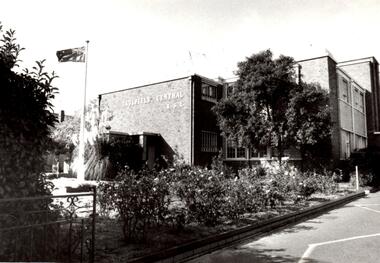
... ... Mather J....Yeates L. Hogue H. Mather J. Wardrop J. Lyons A. M. Ross A. R. Bradley T. ...This file contains six items pertaining to the Caulfield Central RSL: 1/A page to which is attached a black-and-white photograph (date, source and photographer unspecified) of the Caulfield Central RSL, outlying garden and Australian flag. Some writing on the rear identifies the subject. 2/A typewritten letter, (1 page) dated 1946 (no date more specific than that specified), from the Chairman & Honorary Treasurer of the Caulfield Central RSL Appeal Committee (name unspecified) to the Mayor of Caulfield (name also unspecified), imploring the latter for a donation of $20,000 dollars for purposes of constructing a Memorial Hall to eulogize servicemen killed during WWII. Some rough working notes on rear side. 3/A flyer, undated (although presumably published in 1950), printed by Peter Isaacson Pty. Ltd., advertising a concert presented by the Ugly Ugly Man (Frank M. Beard) and the Malvern Tramways’ Harmonica Band to be held at Caulfield Town Hall on 06/06/1950 to assist the Welfare Funds of the Caulfield Central RSL and the Sailors, Soldiers and Airmen’s Mothers’ Association. Also contains an advertisement for a drapery business called Tallents. 4/The annual report of the Caulfield Central RSL, for the period 1952 – 1953. Contains announcements of the annual general meeting and annual elections, the President’s report (in which he principally discusses the club’s charity work and sporting activities), the subcommittee staff roster, the sportsmen’s honour roll, the annual accounts (e.g. balance sheet, income & expenditure statement) and the roster of nominees for office in the committee of management election. 5/A typewritten letter, (1 page) dated 26/11/1982, from Max Brian Blair, Treasurer of the Caulfield Central RSL, to Mr. R. Ballantyne, Secretary of the Caulfield Historical Society, thanking him for his donation to the RSL. 6/A photocopy of an article titled ‘RSL pays $30,000 to buy off objector’ (from the Sunday Herald, by Mary-Anne Toy, dated 16/09/1990), about the Caulfield Central RSL paying local resident Mr. Chris White to withdraw his objection to the RSL’s intention to re-allocate its clubrooms, and the consequent response of the relevant authorities.Black and white photographic print of Caulfield Central RSL buildingOn reverse, PIC B - 5 - CONTACT - RSL BUILDING - CONTACT 28/4/88 - 100% - HAWTHORN ROAD CAULFIELDcaulfield, caulfield central returned servicemen league (rsl), ex-service organisations, clubs and associations, returned servicepeople, armed forces, soldiers, aged people, senior citizens centres, mayors, city of caulfield, war memorials, blamey thomas general sir, white t. w. group capt., gullett h. b. major, beaurepaire frank sir m.l.c., kennedy j. a. m.l.c., warner a. g. m.l.c., michaelis archie m.l.a., dennett a. h. lt.-col. m.l.a., don john capt. m.l.a., reid h. squire m.l.a., brooks w. r. cr., packer j. t. cr., parton e. m. cr., prior p. l. cr., morris t. w. cr., sinclair a. j. g. cr., sims h. e. cr., smith h. c. h. cr., smith james e. cr., tyers s. w. cr., webster harold cr., yorston j. s. cr., briggs r. jas., disney j. s., donath h., llewellyn evans, goddard s. a. padre, lynch p. j., nilsen oliver j. cr., pidd padre a. t., robinson norman, reece harold j., wootton harold s., wallace gordon w., nelson harold g., halls, concerts, musical events and activities, fundraising events, bands, musical ensembles, sailors soldiers and airmen’s mothers’ association, ‘the ugly ugly man’, beard frank m., malvern tramways harmonica band the, caulfield town hall, tallents, drapers, glenhuntly road, glen huntly road, elsternwick, peter isaacson pty. ltd melbourne, annual reports, financial documents, fisher s. w., finch f., williams f., salmon j. e., mallyon v. k., woods w., mayne t. v., lanyon r. j., rowney w. p., williams j. d., pepper e., bathurst t., patterson r., nuzum e. j., phillips e. v., turner g., hawthorn road, byrne l. j., eva a. r., bunny c. l., hoy c. a., orken a., hiam s. f., rawson n. l., coleman g. h., cohen a. s., mason j., goode l. p., nelson h. g., crosbie m. r., mcsweeney t., westley g. de v., greeves c. g., festivals and celebrations, community services, social services, service clubs, ladies auxiliary, returned servicewomen’s section, blamey house, social sub-committee, sport, sporting clubs, tennis, golf, billiards, table tennis, lawn bowls, thompson peter, cricket, children’s health bureau, family welfare bureau, buley doug mr., tomlins m. i., lang a. r., kendall h. i., ford c., munro w., gordon h., rowe s., green j. h., o’brien j., ring t., anderson g. j., croft r. m., jones p. j., la cerf g., roper i., lawrence f., eustace r. c., hanley a., moore a., strachan w. d., gilbert w. f., blair m. r., scriven e. g., miller j. l., hosking b. e., cheeseman r. n., summers s., croy l. w., mclatchie s., williams stan, hattersly cliff, day alf, rawson noel, johnson alby, banham bill, kersey b., williams s., jones a., witten f., waters r., dash r., meldrum i., grant j., haggar l., nightingale n., hallett r., somers r., young g., rawson n., croft r., barton m., o’grady w., cooper p., manton j., sutcliffe a., maver a., challender d., hunt a., parrott e., leicester j., westwood a., rae alex, smith harry, forbes jimmy, johnson jack, higgins w., fink s., hall s., ross m., anderson h., fleming j., bottoms a., peek e., stark j., mathews e., gursansky l., morres r., alenson j., holland i., wallace p., craig h., lucas j., smith h., bretel l., berryman p., reid a., swann j., tully f., henderson g., fields w., johnson j., gloster p., tennat j., boyd a., butterworth k., chapman k., curran j., elkington a. b., evans w., mckenzie d. a., nicol a. b., thompson w., wanliss t. w., watson g. j., williams g., yeomans p., mcgowan h., o’connor k., atherton r., batson s. s., bull e., fletcher a., gorman s. c., hall w., jellett l., lesar h., mather r., nelson n., ratford d., rowe p., turner w. j., wehsack f., williams s. c., wilson a., carter w., forbes i., purvis l., datson r., jackson e., wolstencroft w., smith c., mitchell r., harward j., gillespie ray, hill wally, parkinson w. g., greeves colin mr., water stan mr., selleck f. p., luckins l., andrews f., young v. l., king e. j., mccutcheon j. o., grenfell d. j., hurley c., shand a. r., yeates l., hogue h., mather j., wardrop j., lyons a. m., ross a. r., bradley t., walker r. n., cox f. c., mornane j. s., fletcher a. e., mcneil j. g., rose n., lyons l. j., trevorrow g., wright d. e., walker r., maxwell j., hutchinson j. c., mclean r., caulfield historical society, ballantyne r. mr., blair max brian, toy mary-anne, ruxton bruce mr., administrative appeals tribunal, caulfield city council, white chris mr., northcote avenue, independent church of australia, marsden ian mr., mccutcheon mr -
 University of Melbourne, Burnley Campus Archives
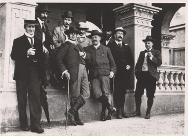
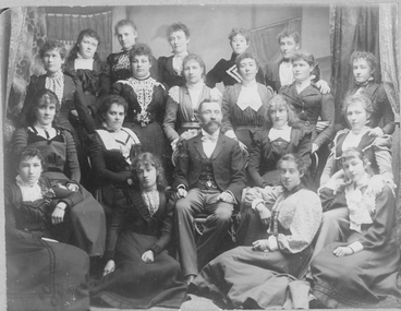
Photograph - Black and white print, John Rickard et al, Wallaby Club, November 1899
... Chapman, F. G. Duffy, J. Mather, J. V. McEacharn, L. Henry, H. B. Higgins and G. ...Chapman, F. G. Duffy, J. Mather, J. V. McEacharn, L. Henry, H. B. Higgins and G. ...Given to John Rickard by a Luffman family member. Sandi Pullman provided digitised copy. Appears in Vol 1 of History Of The Wallaby Club by Alfred Hart (1944)C. B. Luffmann standing with R. G Hyndman, H. H. Chapman, F. G. Duffy, J. Mather, J. V. McEacharn, L. Henry, H. B. Higgins and G. A. Syme outside the Grand Hotel, Yarra Glen. Members of the Wallaby Club (a walking club.)charles bogue luffmann, wallaby club, walking club, principal, yarra glen -
 Sunshine and District Historical Society Incorporated
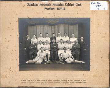
Photograph - Sunshine Porcelain Potteries Cricket Club, Hilda Mitchell, 1934 - 1936
... 1890.01 - Sunshine Porcelain Potteries Cricket Club Premiers 1935 - 36 G Willis Assistant Secretary D Jowett J Cook J Mather J Straughen R Edwards W Kelly F Howarth V Cates J Mather J Thomson F Mason Captain J W Drayton President W Stephenson R Grant Secretary Treasurer A Guy F Edwards F Howarth| 1890.02 - Sunshine Porcelain Potteries Cricket Club Runners Up Season 1934 - 35 J Straughen F Howarth J Hands R Grant Sec Trasurer J Mather J Hewitt M Thomas J Thomson A Beachley Vice President J Mather W Grundy F Mason Captain W J Drayton President P Howarth Vice Captain A Guy J Bean W Jowett V Cater M Nash...Sunshine Porcelain Potteries Cricket Club Cricket Team Photograph 1890.01 - Sunshine Porcelain Potteries Cricket Club Premiers 1935 - 36 G Willis Assistant Secretary D Jowett J Cook J Mather J Straughen R Edwards W Kelly F Howarth V Cates J Mather J Thomson F Mason Captain J W Drayton President W Stephenson R Grant Secretary Treasurer A Guy F Edwards F Howarth| 1890.02 - Sunshine Porcelain Potteries Cricket Club Runners Up Season 1934 - 35 J Straughen F Howarth J Hands R Grant Sec Trasurer J Mather J Hewitt M Thomas J Thomson A Beachley Vice President J Mather W Grundy F Mason Captain W J Drayton President P Howarth Vice Captain A Guy J Bean W Jowett V Cater M Nash 1890.01 - Black & white photograph mounted on card of the Sunshine Porcelain Potteries Cricket Club Premiers 1935 - 36|1890.02 - Black & white photograph mounted on card of the Sunshine Porcelain Potteries Cricket Club Runners Up Season 1934 - 35 Photograph Sunshine Porcelain Potteries Cricket Club Hilda Mitchell ...1890.01 - Sunshine Porcelain Potteries Cricket Club Premiers 1935 - 36 G Willis Assistant Secretary D Jowett J Cook J Mather J Straughen R Edwards W Kelly F Howarth V Cates J Mather J Thomson F Mason Captain J W Drayton President W Stephenson R Grant Secretary Treasurer A Guy F Edwards F Howarth| 1890.02 - Sunshine Porcelain Potteries Cricket Club Runners Up Season 1934 - 35 J Straughen F Howarth J Hands R Grant Sec Trasurer J Mather J Hewitt M Thomas J Thomson A Beachley Vice President J Mather W Grundy F Mason Captain W J Drayton President P Howarth Vice Captain A Guy J Bean W Jowett V Cater M Nashsunshine porcelain potteries cricket club, cricket, team photograph -
 Latrobe Regional Gallery
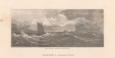
Print, MATHER, John b.1848 Hamilton, Scotland. d. 1916, Bass sighting Wilson's Promontory, 1887
... Signed and dated 'J Mather. 87' lower left corner in printed image. ...Latrobe Regional Gallery 138 Commercial Road Morwell gippsland Signed and dated 'J Mather. 87' lower left corner in printed image. ...EngravingSigned and dated 'J Mather. 87' lower left corner in printed image. -
 Bendigo Historical Society Inc.
Newspaper - JENNY FOLEY COLLECTION: FLAG BEARERS
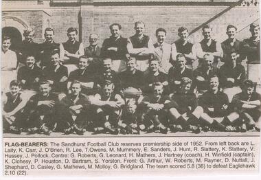
... Roberts, G. Leonard, H. Mathers, J. Hartney (coach), H. Winfield (captain), k. ...Roberts, G. Leonard, H. Mathers, J. Hartney (coach), H. Winfield (captain), k. ...BHS CollectionBendigo Advertiser ''The way we were'' from 2003. Flag-bearers: the Sandhurst Football Club reserves premiership side of 1952. From left back are: L. Laity, K. Carr, J. O'Brien, R. Lee, T. Owens, M. Mummery, E. Sanders, J. Hunt, R. Slattery, K. Slattery, V. Hussey, J. Pollock. Centre: G. Roberts, G. Leonard, H. Mathers, J. Hartney (coach), H. Winfield (captain), k. Clohesy, P. Houston, D. Bartram, S. Yorston. Front: G. Arthur, W. Roberts, m. Rayner, D. Nuttall, J. Shephard, D. Casley, g. Mathews, M. Molloy, G. Bridgland. The team scored 5.8 (38) to defeat Eaglehawk 2.10 (22). The clip is in a folder.newspaper, bendigo advertiser, the way we were -
 Kew Historical Society Inc
Plan - Subdivision Plan, Myrtle Park Estate, City of Camberwell, 1916
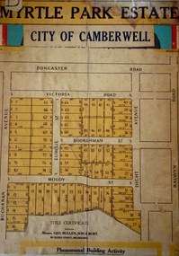
... It is believed that the majority of the plans were gifted to the Society by persons connected with the real estate firm - J. R. Mathers and McMillan, 136 Cotham Road, Kew. ...Myrtle Park Estate, City of Camberwell Plan Subdivision Plan J R Mathers & McMillan ...The Kew Historical Society collection includes almost 100 subdivision plans pertaining to suburbs of the City of Melbourne. Most of these are of Kew, Kew East or Studley Park, although a smaller number are plans of Camberwell, Deepdene, Balwyn and Hawthorn. It is believed that the majority of the plans were gifted to the Society by persons connected with the real estate firm - J. R. Mathers and McMillan, 136 Cotham Road, Kew. The Plans in the collection are rarely in pristine form, being working plans on which the agent would write notes and record lots sold and the prices of these. The subdivision plans are historically significant examples of the growth of urban Melbourne from the beginning of the 20th Century up until the 1980s. A number of the plans are double-sided and often include a photograph on the reverse. A number of the latter are by noted photographers such as J.E. Barnes.The ‘Myrtle Park Estate’ was a subdivision bounded by Victoria Road (now Lansdowne Street), Buchanan Avenue and Dight Avenue. Other streets that were created by the subdivision included Eurolie Street, Boorahman Street and Moody Street (now Sylvan Street). The Estate took its name from Myrtle Park (later changed to Macleay Park), which had been created in 1923 by Camberwell Council. The Park adjoined the southeast corner of the new subdivision. The Estate included 74 regular allotments characterised by narrow frontages and long blocks. Confusion may have greeted prospective purchasers as the Estate was advertised in the daily newspapers as being in East Kew, rather than in Camberwell, where it was at that stage located.subdivision plans - balwyn, myrtle park estate - camberwell [surrey hills] -
 Kew Historical Society Inc
Plan - Subdivision Plan, Central Park Estate, Deepdene - Camberwell, 1923
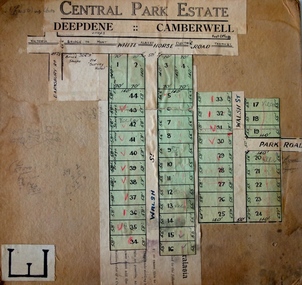
... It is believed that the majority of the plans were gifted to the Society by persons connected with the real estate firm - J. R. Mathers and McMillan, 136 Cotham Road, Kew. ...Central Park Estate, Deepdene - Camberwell Plan Subdivision Plan J R Mathers & McMillan ...The Kew Historical Society collection includes almost 100 subdivision plans pertaining to suburbs of the City of Melbourne. Most of these are of Kew, Kew East or Studley Park, although a smaller number are plans of Camberwell, Deepdene, Balwyn and Hawthorn. It is believed that the majority of the plans were gifted to the Society by persons connected with the real estate firm - J. R. Mathers and McMillan, 136 Cotham Road, Kew. The Plans in the collection are rarely in pristine form, being working plans on which the agent would write notes and record lots sold and the prices of these. The subdivision plans are historically significant examples of the growth of urban Melbourne from the beginning of the 20th Century up until the 1980s. A number of the plans are double-sided and often include a photograph on the reverse. A number of the latter are by noted photographers such as J.E. Barnes.An agent’s board on which parts of an advertisement for the Central Park Estate have been pasted. [The State Library of Victoria holds a complete plan]. Whereas the original plan included black and white photographs and effusive prose about the virtues of the Estate, the item in our collection includes only the actual blocks. The agent has annotated particular blocks to indicate that they have been sold.subdivision plans - deepdene - camberwell, central park estate -
 Kew Historical Society Inc
Plan - Subdivision Plan, Riversdale Estate, 1939
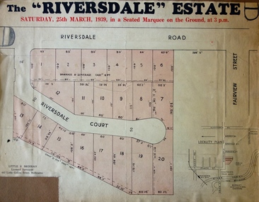
... It is believed that the majority of the plans were gifted to the Society by persons connected with the real estate firm - J. R. Mathers and McMillan, 136 Cotham Road, Kew. ...Riversdale Estate Plan Subdivision Plan J R Mathers & McMillan ...The Kew Historical Society collection includes almost 100 subdivision plans pertaining to suburbs of the City of Melbourne. Most of these are of Kew, Kew East or Studley Park, although a smaller number are plans of Camberwell, Deepdene, Balwyn and Hawthorn. It is believed that the majority of the plans were gifted to the Society by persons connected with the real estate firm - J. R. Mathers and McMillan, 136 Cotham Road, Kew. The Plans in the collection are rarely in pristine form, being working plans on which the agent would write notes and record lots sold and the prices of these. The subdivision plans are historically significant examples of the growth of urban Melbourne from the beginning of the 20th Century up until the 1980s. A number of the plans are double-sided and often include a photograph on the reverse. A number of the latter are by noted photographers such as J.E. Barnes.The Riversdale Estate in Hawthorn created a subdivision of 20 allotments bordering on Riversdale Road and Riversdale Court (which was created by the subdivision). The Locality Plan at right lists the major public buildings in the area: Burnely Horticultural Gardens, Hawthorn Tram Depot and Railway Station, Scotch College and the River Yarra and The Boulevard.subdivision plans - hawthorn, riversdale estate -
 Kew Historical Society Inc
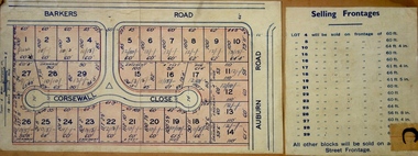
Plan - Subdivision Plan, Corsewall Estate, Hawthorn, 1938
... It is believed that the majority of the plans were gifted to the Society by persons connected with the real estate firm - J. R. Mathers and McMillan, 136 Cotham Road, Kew. ...Corsewall Estate, Hawthorn Plan Subdivision Plan J R Mathers & McMillan ...The Kew Historical Society collection includes almost 100 subdivision plans pertaining to suburbs of the City of Melbourne. Most of these are of Kew, Kew East or Studley Park, although a smaller number are plans of Camberwell, Deepdene, Balwyn and Hawthorn. It is believed that the majority of the plans were gifted to the Society by persons connected with the real estate firm - J. R. Mathers and McMillan, 136 Cotham Road, Kew. The Plans in the collection are rarely in pristine form, being working plans on which the agent would write notes and record lots sold and the prices of these. The subdivision plans are historically significant examples of the growth of urban Melbourne from the beginning of the 20th Century up until the 1980s. A number of the plans are double-sided and often include a photograph on the reverse. A number of the latter are by noted photographers such as J.E. Barnes.This is a second, more complete version of the Corsewall Estate subdivision that is held by the Society. The Coreswall Estate was a subdivision, bordering on Barkers Road and Auburn Road, which created Corsewall Close. This relatively late subdivision included 29 allotments. The subdivision plan includes the dimensions of each lot as well as the width of the existing and projected roads and turning circles. The Corsewall Close Precinct is now listed on the Victorian Heritage Database (HO147) and is noted for its ‘consistent flat-type development over the entire street, which has been cleverly designed to make multi-unit dwellings appear as single buildings’. In this second version of the plan, the rarity of this late subdivision is emphasised by the auctioneers. The original plan must have contained a photograph, which is unfortunately truncated here.subdivision plans - hawthorn, corsewall estate -
 Kew Historical Society Inc
Plan - Subdivision Plan, Mount Ida Estate, 1925
... It is believed that the majority of the plans were gifted to the Society by persons connected with the real estate firm - J. R. Mathers and McMillan, 136 Cotham Road, Kew. ...Mount Ida Estate Plan Subdivision Plan J R Mathers & McMillan ...The Kew Historical Society collection includes almost 100 subdivision plans pertaining to suburbs of the City of Melbourne. Most of these are of Kew, Kew East or Studley Park, although a smaller number are plans of Camberwell, Deepdene, Balwyn and Hawthorn. It is believed that the majority of the plans were gifted to the Society by persons connected with the real estate firm - J. R. Mathers and McMillan, 136 Cotham Road, Kew. The Plans in the collection are rarely in pristine form, being working plans on which the agent would write notes and record lots sold and the prices of these. The subdivision plans are historically significant examples of the growth of urban Melbourne from the beginning of the 20th Century up until the 1980s. A number of the plans are double-sided and often include a photograph on the reverse. A number of the latter are by noted photographers such as J.E. Barnes.The Mount Ida Estate was a subdivision of fifty-two residential allotments bordering Tooronga Road, Leura Grove, Constance Street, and Mount Ida Avenue in Hawthorn East. The report of the sale of the Estate in The Argus (21 September) claimed that over 1,000 people attended the auction and that all allotments were sold on the day. On the other side of Constance Street, the plan identifies the ‘Eastern Recreation Reserve’ (now Anderson Park).subdivision plans - hawthorn -
 Kew Historical Society Inc
Plan - Subdivision Plan, Jaques Estate, 1927
... It is believed that the majority of the plans were gifted to the Society by persons connected with the real estate firm - J. R. Mathers and McMillan, 136 Cotham Road, Kew. ...Jaques Estate Plan Subdivision Plan J R Mathers & McMillan ...The Kew Historical Society collection includes almost 100 subdivision plans pertaining to suburbs of the City of Melbourne. Most of these are of Kew, Kew East or Studley Park, although a smaller number are plans of Camberwell, Deepdene, Balwyn and Hawthorn. It is believed that the majority of the plans were gifted to the Society by persons connected with the real estate firm - J. R. Mathers and McMillan, 136 Cotham Road, Kew. The Plans in the collection are rarely in pristine form, being working plans on which the agent would write notes and record lots sold and the prices of these. The subdivision plans are historically significant examples of the growth of urban Melbourne from the beginning of the 20th Century up until the 1980s. A number of the plans are double-sided and often include a photograph on the reverse. A number of the latter are by noted photographers such as J.E. Barnes.The Jaques Estate was a small subdivision of eight residential allotments bordering Jaques Street and Barkers Road in what is now Hawthorn East. Advertised in The Argus as being in ‘Upper Hawthorn’ the subdivision was claimed to include: ‘charming villa sites in excellent situations, with every convenience available, and with superior homes surrounding’.subdivision plans - hawthorn, jaques estate -
 Kew Historical Society Inc
Plan - Subdivision Plan, Houghton Street & Buchanan Avenue, Balwyn North, ca. 1906
... It is believed that the majority of the plans were gifted to the Society by persons connected with the real estate firm - J. R. Mathers and McMillan, 136 Cotham Road, Kew. ...Houghton Street & Buchanan Avenue, Balwyn North Plan Subdivision Plan J R Mathers & McMillan ...The Kew Historical Society collection includes almost 100 subdivision plans pertaining to suburbs of the City of Melbourne. Most of these are of Kew, Kew East or Studley Park, although a smaller number are plans of Camberwell, Deepdene, Balwyn and Hawthorn. It is believed that the majority of the plans were gifted to the Society by persons connected with the real estate firm - J. R. Mathers and McMillan, 136 Cotham Road, Kew. The Plans in the collection are rarely in pristine form, being working plans on which the agent would write notes and record lots sold and the prices of these. The subdivision plans are historically significant examples of the growth of urban Melbourne from the beginning of the 20th Century up until the 1980s. A number of the plans are double-sided and often include a photograph on the reverse. A number of the latter are by noted photographers such as J.E. Barnes.A hand-drawn subdivision plan listing six blocks bounded by Houghton Street, Doncaster Road, Buchanan Avenue and Maud Street, North Balwyn. Written on the plan of subdivision are the lot numbers, the dimensions of the blocks and the price at which two lots were for sale or had been sold for.subdivision plans - balwyn -
 Kew Historical Society Inc
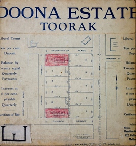
Plan - Subdivision Plan, Doona Estate, Toorak, 1929
... It is believed that the majority of the plans were gifted to the Society by persons connected with the real estate firm - J. R. Mathers and McMillan, 136 Cotham Road, Kew. ...Doona Estate, Toorak Plan Subdivision Plan J R Mathers & McMillan ...The Kew Historical Society collection includes almost 100 subdivision plans pertaining to suburbs of the City of Melbourne. Most of these are of Kew, Kew East or Studley Park, although a smaller number are plans of Camberwell, Deepdene, Balwyn and Hawthorn. It is believed that the majority of the plans were gifted to the Society by persons connected with the real estate firm - J. R. Mathers and McMillan, 136 Cotham Road, Kew. The Plans in the collection are rarely in pristine form, being working plans on which the agent would write notes and record lots sold and the prices of these. The subdivision plans are historically significant examples of the growth of urban Melbourne from the beginning of the 20th Century up until the 1980s. A number of the plans are double-sided and often include a photograph on the reverse. A number of the latter are by noted photographers such as J.E. Barnes.The Doona Estate subdivision of 1929 created 11 new allotments bordered by Glenferrie Road, Stonnington Place, Cross and Church Streets. On the right of the plan, the location of ‘State Govt. House’ is noted. Stonnington was to be maintained as Victoria’s Government House until 1931, two years after the Doona Estate subdivision was released.subdivision plans - toorak, doona estate -
 Kew Historical Society Inc
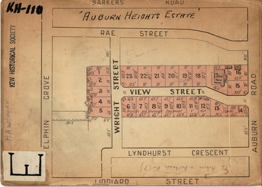
Plan - Subdivision Plan, Auburn Heights Estate, 1921
... It is believed that the majority of the plans were gifted to the Society by persons connected with the real estate firm - J. R. Mathers and McMillan, 136 Cotham Road, Kew. ...Auburn Heights Estate Plan Subdivision Plan J R Mathers & McMillan ...The Kew Historical Society collection includes almost 100 subdivision plans pertaining to suburbs of the City of Melbourne. Most of these are of Kew, Kew East or Studley Park, although a smaller number are plans of Camberwell, Deepdene, Balwyn and Hawthorn. It is believed that the majority of the plans were gifted to the Society by persons connected with the real estate firm - J. R. Mathers and McMillan, 136 Cotham Road, Kew. The Plans in the collection are rarely in pristine form, being working plans on which the agent would write notes and record lots sold and the prices of these. The subdivision plans are historically significant examples of the growth of urban Melbourne from the beginning of the 20th Century up until the 1980s. A number of the plans are double-sided and often include a photograph on the reverse. A number of the latter are by noted photographers such as J.E. Barnes.The name ‘Auburn Heights Estate’, was handwritten on the subdivision plan, and included 23 lots in Auburn Road and Wright and View Streets, Hawthorn. Most of the houses built on the lots that were sold still exist. The house built on number 8 View Street is a contemporary exception. The subdivision included an existing home at number 17 View Street.subdivision plans - hawthorn, auburn heights estate -
 Kew Historical Society Inc
Plan - Subdivision Plan, Corsewall Estate, 1938
... It is believed that the majority of the plans were gifted to the Society by persons connected with the real estate firm - J. R. Mathers and McMillan, 136 Cotham Road, Kew. ...Corsewall Estate Plan Subdivision Plan J R Mathers & McMillan ...The Kew Historical Society collection includes almost 100 subdivision plans pertaining to suburbs of the City of Melbourne. Most of these are of Kew, Kew East or Studley Park, although a smaller number are plans of Camberwell, Deepdene, Balwyn and Hawthorn. It is believed that the majority of the plans were gifted to the Society by persons connected with the real estate firm - J. R. Mathers and McMillan, 136 Cotham Road, Kew. The Plans in the collection are rarely in pristine form, being working plans on which the agent would write notes and record lots sold and the prices of these. The subdivision plans are historically significant examples of the growth of urban Melbourne from the beginning of the 20th Century up until the 1980s. A number of the plans are double-sided and often include a photograph on the reverse. A number of the latter are by noted photographers such as J.E. Barnes.The Corsewall Estate was a subdivision, bordering on Barkers Road and Auburn Road, which created Corsewall Close. This relatively late subdivision included 29 allotments. The subdivision plan includes the dimensions of each lot as well as the width of the existing and projected roads and turning circles. The Corsewall Close Precinct is now listed on the Victorian Heritage Database (HO147) and is noted for its ‘consistent flat-type development over the entire street, which has been cleverly designed to make multi-unit dwellings appear as single buildings’.subdivision plans - hawthorn, corsewall estate -- hawthorn (vic.) -
 Kew Historical Society Inc
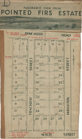
Plan - Subdivision Plan, Pointed Firs Estate, 1936
... It is believed that the majority of the plans were gifted to the Society by persons connected with the real estate firm - J. R. Mathers and McMillan, 136 Cotham Road, Kew. ...Pointed Firs Estate Plan Subdivision Plan J R Mathers & McMillan ...The Kew Historical Society collection includes almost 100 subdivision plans pertaining to suburbs of the City of Melbourne. Most of these are of Kew, Kew East or Studley Park, although a smaller number are plans of Camberwell, Deepdene, Balwyn and Hawthorn. It is believed that the majority of the plans were gifted to the Society by persons connected with the real estate firm - J. R. Mathers and McMillan, 136 Cotham Road, Kew. The Plans in the collection are rarely in pristine form, being working plans on which the agent would write notes and record lots sold and the prices of these. The subdivision plans are historically significant examples of the growth of urban Melbourne from the beginning of the 20th Century up until the 1980s. A number of the plans are double-sided and often include a photograph on the reverse. A number of the latter are by noted photographers such as J.E. Barnes.An almost identical plan of the ‘Pointed Firs Estate’ is in the State Library of Victoria. The plan unusually uses a photograph to show the panoramic views from the Estate. A prospective purchaser could expect to look across the Yarra Valley to Eaglemont and Heidelberg. The 36 lots advertised for sale faced Doncaster Road, Houghton Street, Maud Street and Thackray Street in Balwyn North.subdivision plans - balwyn, pointed firs estate -
 Kew Historical Society Inc
Plan - Subdivision Plan, Lodged Plan No.6518, 1920-1940
... It is believed that the majority of the plans were gifted to the Society by persons connected with the real estate firm - J. R. Mathers and McMillan, 136 Cotham Road, Kew. ...It is believed that the majority of the plans were gifted to the Society by persons connected with the real estate firm - J. R. Mathers and McMillan, 136 Cotham Road, Kew. ...The Kew Historical Society collection includes almost 100 subdivision plans pertaining to suburbs of the City of Melbourne. Most of these are of Kew, Kew East or Studley Park, although a smaller number are plans of Camberwell, Deepdene, Balwyn and Hawthorn. It is believed that the majority of the plans were gifted to the Society by persons connected with the real estate firm - J. R. Mathers and McMillan, 136 Cotham Road, Kew. The Plans in the collection are rarely in pristine form, being working plans on which the agent would write notes and record lots sold and the prices of these. The subdivision plans are historically significant examples of the growth of urban Melbourne from the beginning of the 20th Century up until the 1980s. A number of the plans are double-sided and often include a photograph on the reverse. Reconciling this hand-drawn subdivision plan with a modern map of the area is initially a challenge due to a change of street names. Argyle Road in the centre of the subdivision was to be renamed Deepdene Road, and the street named Deepdene Road on the plan was to become Deepdene Place. Of interest is the nursery on the corner of Argyle and Whitehorse Roads. During this period there were a number of nurseries servicing the Kew and Balwyn areas. The subdivision was essentially of the land formerly occupied by the house 'Deepdene'.subdivision plans - balwyn, deepdene, whitehorse road -- deepdene (vic.), deepdene road -- deepdene (vic.), burke road -- deepdene (vic.) -
 Stawell Historical Society Inc
Photograph, 1 Male & 19 Females (named) Mr S Trend was head teacher at Stawell State School Number 502 1895-1899
... Row from left 1st row. L. Parry, J. Mathers, F. McGregor, N. McCann, E. Lemon. 2nd row. ...No history of this photo was provided. stawell Row from left 1st row. L. Parry, J. Mathers, F. McGregor, N. McCann, E. Lemon. 2nd row. ...Portrait of a Group of People. 1 Male & 19 Females (named) Mr. S. Trend was head teacher at, SS 502 1895-1899. Group are dressed in formal clothing. The male in three piece suit with bow tie. Women in long dresses with lace around the collars. No history of this photo was provided.Group of people 20 people, one male seated in the middle with 19 females seated and standing in the photo.Row from left 1st row. L. Parry, J. Mathers, F. McGregor, N. McCann, E. Lemon. 2nd row. C. McGregor, O. Butcher, A. Henderson, F. Nicholson, S. McPherson, S. Lemon. 3rd row. M. Henderson, C. Thomas, Mr. S. Trend, O. Stout. L. Trend. 4th row. A. Parry, R. McMullin, M. Crerar, M. McLean.stawell -
 Kew Historical Society Inc
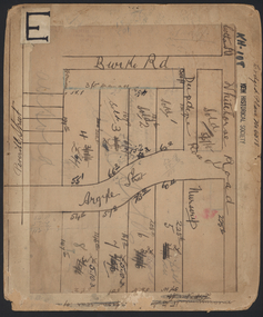
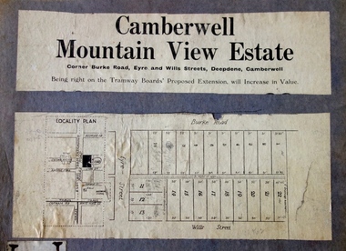
Plan - Subdivision Plan, Camberwell Mountain View Estate, 1923
... It is believed that the majority of the plans were gifted to the Society by persons connected with the real estate firm - J. R. Mathers and McMillan, 136 Cotham Road, Kew. ...Camberwell Mountain View Estate Plan Subdivision Plan J R Mathers & McMillan ...The Kew Historical Society collection includes almost 100 subdivision plans pertaining to suburbs of the City of Melbourne. Most of these are of Kew, Kew East or Studley Park, although a smaller number are plans of Camberwell, Deepdene, Balwyn and Hawthorn. It is believed that the majority of the plans were gifted to the Society by persons connected with the real estate firm - J. R. Mathers and McMillan, 136 Cotham Road, Kew. The Plans in the collection are rarely in pristine form, being working plans on which the agent would write notes and record lots sold and the prices of these. The subdivision plans are historically significant examples of the growth of urban Melbourne from the beginning of the 20th Century up until the 1980s. A number of the plans are double-sided and often include a photograph on the reverse. A number of the latter are by noted photographers such as J.E. Barnes.The so-called Camberwell Mountain View Estate was a subdivision on ‘the corner [of] Burke Road, Eyre and Wills Streets, Deepdene’. The Estate was not the first attempt to subdivide this land holding. In 1884, 1888 and 1894 the Belmore Park subdivision proposed 18 allotments for this parcel of land. The final stages of the Belmore Park subdivision occurred during the Depression of the 1890s. Apart from perhaps one block facing Burke Road, which is unnumbered in the Mountain View Estate subdivision, the rest must have remained unsold. The later subdivision would redraw the original 18 allotments, creating 22 new lots. In the Locality Plan on the left side of the subdivision plan, Deepdene Station, which formed part of the Outer Circle Railway is represented, as is the location of Deepdene Primary School. A selling point was the proposed extension of the Burke Road tram beyond its terminus at Cotham Road. The extension did not eventuate.subdivision plans - camberwell, mountain view estate -
 Glen Eira Historical Society
Letter - MURRUMBEENA FOOTBALL CLUB
... Callaghan T. Mathers R. Andrew J. Halfpenny J. Howland W. MThis file contains 2 items: 1/A letter to Caulf Historical Society, requesting any history of Murrumbeena Football Club, from R. Gould. Reply from T.J. Hart advising that no information on the club is held by the society. 2/A fifty page book on the history of Murrumbeena Football Club, from foundation in 1927 to 1976. Includes 7 team photocopied photographs and one of the pavilion after completion in 1922, book written by R. Gould.gould ross, murrumbeena football club, football, football clubs, ‘dick’s horse paddock’, butchers, murrumbeena, great dandenong road, murrumbeena road, n.r. cooper, market gardens, orchards, carnegie rovers, oakleigh juniors, oakleigh district junior, football association, committees of management, murrumbeena junior football club, dick r., armstrong j., silverman dr. i., phillips r. cr., mudge les, truman v., bristow l., richardson , truman t., robertson, carnegie rovers, bentleigh, oakleigh juniors, ted pelling’s horse stables, stables, kangaroo road, moore george, armstrong fred, tinsley roy, naylor reg, ward bill, hunter mr., cox mr., scivenor mr., marian mr., wilde mr., townley mr., mudge mr., hay mr , ferguson mr., wilde wal, pelling e., watkins e., giles mr., young mr., paterson mr., reid mr., ross mr., walker mr., lyre mr., cannon mr., ronaldson tom, pearson , hall , collaghan jack, dennis, wlash, cannon, rickets, ferguson, wotes, hay, washbrooke, wilde , phillipson, welch, brown, cox, sharp, thomas, palmer, harris e., dick a., caulfield-dandenong, junior football association, metropolitan amateurs, pavilions, caulfield city council, murrumbeena amateurs, miss football queen, ralph miss, welch vic, emmins ‘titch’ g., bone r., havell, ellis r. (bob), pew t., stock a., riley wal, harris ‘codger’ roy, biddington j., nicholson a., bernes a.c., healey g., riley w., summerfield d., lee e., harris j., bass j., denning j., phillips c., king f., weatheral n.w., stewart s., rolfe h., dalgleish s., malone l., simpson e., kain a., rennie w., sloan a., painter e., bernes c., biddington g., parker c., willmott n., murrumbeena cricket club, corbett, murrumbeena districts, holden ‘rusty’, crundy, dean, taylor, bourke, moore, stewart, hause, clarke, gear, page, rowe bill, mathers alf, awards, farrell r., oakley r., escott l., callaghan t., mathers r., andrew j., halfpenny j., howland w., m
Glen Eira Historical SocietyBook - Carnegie Primary School No. 2897
... Mathers Max Howie Rex Major Mr. Flatmans paddock Crossover Reid Eric Reid Athol Lowe Margaret Lowe Dorothy Lowe Ian Poliomyelitis epidemic Diseases Forsythe Miss Cuddihy Miss Dougall Keith Grace Miss Hattam’s Stores Driver Wally Perry Max Perry Don Perry Jack Meagher J. ...Carnegie Primary School centenary book (96 pages x 2 copies) ‘The First Hundred Years NO2897. Carnegie Primary School 1888-1988’ compiled and edited by Isabel Couper and Deidre Lynch. A detailed history of the school’s beginnings. Many informative memories and recollections from school’s first students and teachers; includes social history of area and people, football teams, debutante sets and school. Also a reprinted newspaper article from school’s Golden Anniversary and photo of school band; and a couple of social history photographs.anderson james, murrumbeena, glen huntly railway station, carnegie state school, wesleyan hall, neerim road, railway stations, carnegie primary school, rosstown, toolambool road, lynch deidre, mcvey claire, ross william murray, findlay francis, couper isabel, brown wesley, rosstown state school, brisbane w, carnegie uniting church, liddelow m.h., evans thomas, selboskar phyl, centenaries, margaret street, caulfield, brewster mr., taylor mr., draper mrs., mcfarlane mr., rule thomas, teachers, campbell ada, ‘ava’, campbell aubrey, campbell vera, matthews ben, hewitts road, matthews funeral service, funeral parlours, leo amy, leo alfie, rudge family, rudge mr., transport, phillips store, general store, phillips corner, emily street, hamlya family, pitt family, sheppard family, pemberton mr., pemberton mrs., dunlop misses, preschools, whitlam family, whitlam gordon, woods family, woods lorna, swaggie, swagman, liddelow amy, anderson mr., anderson archie, dunlop bill, phillips linda, hansen alice, lodge laura, fox arthur , hamlyn eric, hansen dagmar, cooper lina , woods lorna, waite family, cove family, johansen family, koornang road, market gardens, sheppard ernie, wood a.m., ‘nisava’, wood family, wood bill, evans rachel, evans thomas, wood millicent, whitfield mr., griffiths mr., wood malcolm, wood forest, wood joe, roxburgh miss, grange road, clifton street, lord street, wood frederick geo, egan miss dressmakers, whitlam fred, whitlam christine, whitlam george, whitlam gough, whitlam freda, whitfield mr., patterson road, graceburn avenue, griffiths r.h., koornang road, scales mr., reid athol, lording dr., mernda ave, farmstead, lord reserve, leman’s swamp, koornang park, cobby harry, larkin aircraft company, dawson howard, rosedale avenue, spencer reg, turner ruth, turner jack, turner noreen, turner marie, morton alan, morton barney, gardiner martin, frogmore estate, oakleigh road, frogmore road, koornang park, hunt club kennels, raeke miss, morgan miss, pitt winnie, jiggins mr., smith mr., blundy violet, ryall ray, mimosa road, wolseley mr., wolseley family, wolseley ted, brunstein madge, murrumbeena cricket club, sinclair alan, sincliar tinny, thomas ted, walker alec, bone bob, footballers, middleton colin, farquahson mrs., eddy family, eddy rose, wolseley jack, buswell stan, buswell doug, buswell. stan jnr., irving nell, brims ethel, bailey bruce, eason sisters, hands hilda, windlow isabel, madden road, glenhuntly road, griffiths rita, jackson jean, scott mr., ward ‘cap’, caulfield grammar school, kokaribb road, carnegie traders, cricket teams, carnegie south, ward marjory, ryan mr., phillips tony, phillips bessie, buckley street, phillips harriet, phillips marion, phillips ernest, phillips hilda, phillips david, phillips florence, phillips linda, lihou miss, jersey parade, meake family, skewe family, mansfield family, fraser jean, collister alma, sturges millie, retallick girls, lillywhite family, mason nellie, johns nancy, bowsfield family, jenner family, chisholm emma, chisholm doris, chisholm ivy, chisholm netta, chisholm beryl, chisholm eileen, wadsworth ethel, luke mr., plummer t.w., raecke miss, sargent ron, sarkie family, reid family, meake violet, collett reg, mcneil miss, scales mr., carmody thomas william, steele miss, young mac, young margaret, cooper cyril, cooper bill, whiteside d., broadbent neil, broadbent mr., carnegie theatre, theatres, morton family, clarke family, quickand neals grocery store, grocers, billy guyatt’s, shops, spencer the removalist, removalists, collister harold, collister bill, caulfield band, bands, carthews the drapers, drapers, mccarrons alec blacksmiths, skewes keith, oliver frank, pitt ‘squeaker’, knevitt ‘skeeter’ harry, jockeys, britter jack, stanistreet family, gear rita, culleen billy, tailors, sherwoods butchers, butchers, jersey parade, riley didlo, verne harry, cooper horace, cooper linda, cooper martin, cooper claude, cooper reginald, cooper stanley, cooper gladys, cooper muriel, cooper percival, cooper cyril, beaumont w.a., whittfield joe, beaumont eileen, major mary anne sister, major myrtle, major bessie, major alma, stagholl walter, stagholl margaret, stagholl eric, robertson bessie, robertson fred, robertson norman, robertson donald, robertson alma, robertson alan, baird neil, baird john, baird rosemary, dunn helen, baird ian, baird heather, baird dianne, petrie stuart, petrie richard, bailey ron, gaunt mabel, reading harold, reading marge, irwin joyce, dickson margaret, dickson jennifer, dickson peter, wood malcolm, wood millicent, wood forest, wood joe, sinclair ‘trinny’, roberts ‘fly’, footballers, malcolm mr., henderson reg, henderson alice, brew l., rule mr., philbrick mr., wood mr., trembath mr., keogh mr., plummer tom, lane a., fox ernest, souters, market gardeners, fox belle, fox bella, fox vern, couper margaret, couper sandra, couper peter, couper narelle, couper clare, couper jarrod, scott mr., doughty will, doughty tom, lloyd miss, islingworth master, adams joyce, hogan mr., markus jean, cosgrove joan, cosgrove mrs., cosgrove mr., marshall jim, kellow fred, fretwell elizabeth, fretwell betty, shepparson ave, singers, edmonson miss, butters shirley, harwood vera, bracher lloyd, dewhurst irene, dewhurst jack, boyle mr., gow jack, welch len, stanistreet harry, stanistreet jack, stanistreet kathleen, stanistreet frank, stanistreet kingsley, ‘ray sullivan’s harmony boys’, carnegie memorial hall, st. anthony’s hall, welch len, gibbons norm, ashley sylvia, crosswell edna, marks peggy, worth phyllis, cleal jean, tabner edith, jenkins elva, mcintosh gladys, worth reg, waters cyril, downard rex, wild mavis, wild darby, hill roland, eason jean, tyers noel, tyers clive, witten hope, strickland doris, chisholm beryl, harwood family, battershill sid, battershill walter, dixon mavis, boyle mr., ford hilda, forsythe miss, edmonsen miss, ryan mr., grimsley mr., allaway mrs., grant mrs., bone bob, bone bruce, w. bone & son nursery men, bone norman, bone jack, bone william, railway road, green kevin, paris marjorie, mimosa road, green joan, allaway winnie, elliot miss, mcburney mr., purdy mrs., allaway suzanne, barron shirley, hogan mr., rutherford mrs., curtin mr., mckee’s, stores, whelan’s, coles, koornang road, gardiner marty, grange road dairy, dairies, mcwhinney’s tuck shop, shops, williams dorothy, kennedy irene regina, rigby miss, grimsley steve, grimsley muriel, grimsley jack, grimsley margaret, grimsley aimee, grimsley bill, blinkinsop steve, blinkinsop jeannie, mathers max, howie rex, major mr., flatmans paddock, crossover, reid eric, reid athol, lowe margaret, lowe dorothy, lowe ian, poliomyelitis epidemic diseases, forsythe miss, cuddihy miss, dougall keith, grace miss, hattam’s, stores, driver wally, perry max, perry don, perry jack, meagher j., ‘hostile’, racehorses, edney jack, carthews the drapers, fretwell elizabeth, kellow fred, muddyman bill, graceburn ave, caulfield junior citizens band, bands, luke mr., luke percy, luke maise, luke nessie, luke geoff, luke ross, luke jan, luke lynette, bolton douglas, anderson mrs., mcburney mr., hogan mr., scott mr., tyers s., ross j., ryan j., irvine j., muirhead mrs., muirhead j., mcnab m., buller l., emmanuel p., buller m., paton v., moor j., condron a., bibby d., matthews n., holman l., cotterell m., whelan j., jennion g., walker b., taylor e., green a., turner r., matthews e., smith joan, gardiner marty, dairies, hanson family, cove family, gallop family, barrett family, barrett w.a., bolch family, bolch b., burke w., burke bill, burke s., mobbs h., young g., young c., burke m., ward c., hopwood g., gordon mr., milk bars, cooper cr., phillips t., swindell mr., grogan mr., wadsworth mrs., bourke mrs., lewis mrs., worsley mrs., quickenstead mrs., brown wesley, musicians, purdy h., curtain les, jenner’s dairy, riley’s wood yard, occupations, jenner vic, jenner les, grant noel, parker george, connolly keith, purdy mr., glen huntly picture theatre, picture theatres, irvine jack, law christie, hatter bob, joppick les, driver geoff, curtin mrs., frederick street, ormond, waters ron, carnegie junior citizens band, carnegie salvation army band – bands, whelan evan, irwin ray, balgleish jack, cowen laurie, smyth wally, lambeth margaret, kind lorraine, bondini joy, tredennick miss, linton miss, heath graham, shiell bill, shiell myrtle, archard bess, bull joan, craig ida, collins dorrie, collins doreen, diggans jess, cornthwaite h., cripps e., dougall n., dixon joyce, francis d., evans mrs., glass peg, greene jess, grace merle, hocking freda, jillings mrs., price mrs., day kitty, kerr may, mason marge, kind sylvia, muirhead d, mcconchie netta, needham nancy, nickless w, o’connor linda, pilven mrs., ryall h., strother ivy, singleton mrs., kelly phyl, waters von, usher mrs., trotter maude, watson mrs., williams mabel, withers olive, aarsmann norma, shiell norma, close peter, ‘wild cherry’ cake shop, rudi miss, anderson miss, eddy mr., hunter jean, nelson vera, fisher john, hunter ron, read jean, smith brian, newsreaders, nelson miss, singleton billy, quon miss, mchutchison george, valma smith, millar royal r., donoghue nora, lester mr., roberts tom, andreisen colin, miles alec, hine mr., baker mr., clements george, bracher lloyd, dimick miss, muir judy, dunn margaret, sant richard, myring miss, ryan mr., armstrong margaret, share wally, howie rex, barclay bob, rockman udo, hoult david, eisfelder kevin, jacques mr., smith mr., magee mr., stehle belinda, wallace mr., james mrs., main mr., wood miss, verso mr., mcpherson mrs., felotico miss, stehle john, howards mrs., collard mrs., webster vivian, stehle siggy, truong le sen, mcpherson barbara, mitchell eva, moutsos mark, chan benjamin, wilson del, jewell christopher, mitchell keith, grant marilyn, caskie alastair, dixon dennis, armstrong john, lucas edward, clark deanne, coutts natalie, flood zivanja, derham peter, momandwall shaper, couper jarrod, heslop joanne, breeze ginaya, caskie fiona, filippone nadya, mcmahon nina, hedges nigel, williams shae, grimm karen, mcgregor clare, vagenes john, gallagher glenn, mcalister rob, varga marilyn, hunter debbie, courtney cathy, booth carol, mcmahon mary, brown danielle, burska maciej, campbell jason, chryssis aris, d’arcy michael, delaney matthew, doukas vivian, dower samantha, fournarakis andrew, genoli amanda, grammatos jimmy, harrington melanie, karamoshos john, karim sadruddin, kennedy russel, lalani zahra, lightfoot kylie, looby mark, louange veronica, park sung mi, perera dennis, pozvek julie, scurry kate, sievers sarah, smith matthew, svarnas dennis, vassiliou denise, wright tracey, zouzounis spirros, adahall jojie, agar jude, anderson lynette, black renae, bobrowski ursula, caskie catherine, devon hayley, diakoumis maria, duljas kristie, evans lindsay, faucett ebony, filippone annette, fournarakis jimmy, francese sean, gibson jay, gordon michelle, guslitser dora, king jane, lianos villi, lorkin christopher, macleod cheryl, maggs amberley, mitchell keith, mucic renae, o’brien jessica, park matthew, pozvek richard, psarras nancy, rhodes suzanne, simons emma, smith christopher, spokes melanie, tia michael, timewell amanda, vavoudis peter, abbott kristi, allender daniel, bobrowski jacob, carey rebecca, carter daimein, catramados john, christou eugenia, couper jarrod, healey michael, kalaitzakis nick, kennedy rebecca, macleod suzanne, mavridis angelo, morosini amanda, mowforth dustin, okolicsanyi george, park sung chul, pemberton michael, reisman elizabeth, richards kylie, savrone leah, tia charlie, tran paul, wiseman derek, wright dean, wyatt marilyn, andre ryan, breeze ginaya, brown james, campbell chad, charles benjamin, devon john, diakmoumis stacey, diamantis chris, duljas michael, grammatos harry, hill bradd, karim salim, lindsay amanda, lynch jennifer, marrello sol, momandwall shaker, moutsos ireni, oram scott, o’sughrue kristy, panevin david, park catherine, pozvek louise, stratton alisa, timewell rebecca, tsigos stam, yeow sook ling, anderson peter, batson tracey, black craig, brain jason, breeze benjamin, brown kylie, carrington harata, caskie fiona, catramados hercule, chan daphne, christou chris, clarke simone, diamantis anthony, faucett sara, flood natalia, holmes gavin, kotrotsos tony, kuk robin, mitchell david, okolicsanyi steve, pemberton samuel, soos melinda, stephenson gabrielle, tran pauline, vassiliou evan, agar natalia, bennett tracey, buhmann wayne, couper clare, faucett sean, filippone nadya, filippone marie, gallagher glenn, gelman roman, grant shawn, hill tania, jewel chris, kaliappa danny, kiss robert, liacopoulos aris, louey david, macleod mike, malamas voula, oram michelle, scurry ivan, wardley amanda, zouzounis sam, anderson robert, antoniou nick, carey tamara, derham peter, diep dianne, filippone danielle, flood zivanja, frangos katina, handley scott, harrison robin, heath cheryl, hedges megan, hedges nigel, hudson raelene, jacovou daniel, katrotsos george, kuk maggie, leung tracy, lightfoot wendy, mcmahon nina, taylor stephen, vassiliou litsa, liddelow e., anderson james h., boardman thomas h., rule thomas, whitfield j.p., griffiths r.h., scales e., boyle j.b., ryan owen w., eddy h.m., millar royal r., lester russel a., donoghue r., bracher a. lloyd (acting principle), o’brien john d., moller henry r., monahan t.v., barclay robert l., somerville albert v., magee frank c. (acting principle), wallis keith, laing allan i., verso ron (acting principle), wood moira (acting principle), tonkin ernest, share wallace (acting principle), howie rex, harding malcolm (acting principle), crowe brian, schmidt david (acting principle), lynch deidre (acting principle), o’keeffe leo, brierley bob, brierley marjorie, couper isabel, couper peter, lindsay janine, lynch deidre, selboskar phyl, stehle siggy, webster jennifer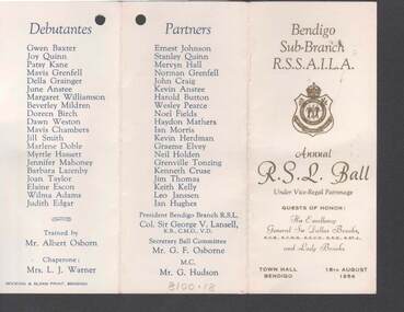 Bendigo Historical Society Inc.
Document - R.S.L. BENDIGO COLLECTION: ANNUAL R.S.L. BALL 1954, 18th August, 1954
... J Warner. Partners: Ernest Johnson, Stanley Quinn, Mervyn Hall, Norman Grenfell, John Craig, Kevin Anstee, Harold Button, Wesley Pearce, Noel Fields, Haydon Mathers, Ian Morris, Kevin Herdman, Graeme Elvey, Neil Holden, Grenville Tonzing, Kenneth Cruse, Jim Thomas, Keith Kelly, Leo Janssen and Ian Hughes. ...J Warner. Partners: Ernest Johnson, Stanley Quinn, Mervyn Hall, Norman Grenfell, John Craig, Kevin Anstee, Harold Button, Wesley Pearce, Noel Fields, Haydon Mathers, Ian Morris, Kevin Herdman, Graeme Elvey, Neil Holden, Grenville Tonzing, Kenneth Cruse, Jim Thomas, Keith Kelly, Leo Janssen and Ian Hughes. ...Two copies of the Bendigo Sub-branch R.S.S.A.I.L.A. Annual R.S.L. Ball held at the Town Hall, Bendigo on 18th August 1954. Guests of Honour were His Excellency General Sir Dallas Brooks, K.C.B., K.C.M.G., K.C.V.O., D.S.O., K.ST.J., and Lady Brooks. Card is cream with gold print on the front and a gold RLS badge. Other printing is blue. The inside of the tri-fold card has a Dance Program of 28 dances and a space for Autographs. The other side has the Debutantes: Gwen Baxter, Joy Quinn, Patsy Kane, Mavis Grenfell, Della Grainger, June Anstee, Margaret Williamson, Beverley Mildren, Doreen Birch, Dawn Weston, Mavis Chambers, Jill Smith, Marlene Doble, Myrtle Hassett, Jennifer Mahoney, Barbara Lazenby, Joan Taylor, Elaine Escon, Wilma Adams and Judith Edgar. Trained by Mr Albert Osborn. Chaperone: Mrs L J Warner. Partners: Ernest Johnson, Stanley Quinn, Mervyn Hall, Norman Grenfell, John Craig, Kevin Anstee, Harold Button, Wesley Pearce, Noel Fields, Haydon Mathers, Ian Morris, Kevin Herdman, Graeme Elvey, Neil Holden, Grenville Tonzing, Kenneth Cruse, Jim Thomas, Keith Kelly, Leo Janssen and Ian Hughes. President Bendigo Branch R.S.L: Col. Sir George Lansell, K.B., C.M.G., V.D. Secretary Ball Committee: Mr G F Osborne. M.C. Mr G Hudson. Printed by Hocking & Sloan Print, Bendigo.Hosking & Sloan Print, Bendigoevent, social, annual ball, r.s.l. bendigo collection - annual r.s.l. ball 1954, his excellency general sir dallas brooks, lady brooks, gwen baxter, joy quinn, patsy kane, mavis grenfell, della grainger, june anstee, margaret williamson, beverley mildren, doreen birch, dawn weston, mavis chambers, jill smith, marlene doble, myrtle hassett, jennifer mahoney, barbara lazenby, joan taylor, elaine escon, wilma adams, judith edgar, mr albert osborn, mrs l j warner, ernest johnson, stanley quinn, mervyn hall, norman grenfell, john craig, kevin anstee, harold button, wesley pearce, noel fields, haydon mathers, ian morris, kevin herdman, graeme elvey, neil holden, grenville tonzing, kenneth cruse, jim thomas, keith kelly, leo janssen, ian hughes, col sir george v lansell, mr g f osborne, mr g hudson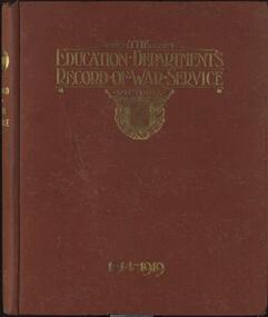 Federation University Historical Collection
Book, The Education Department's Record of War Service, 1914-1919, 1921
... Mather Hard covered book of the Victorian Education Department personnel who served World War One. Contents include the men who enlisted, the men who fell, the men who returned, honours and decorations, memorials, Education Department's War Relief Organisation, Comforts for Soldiers, War Savings. Artwork was done by the students of the Ballarat Technical Art School, a division of the Ballarat School of Mines. Page 9 Contents page was done by Percy Trompf. The Education Department's Record of War Service, 1914-1919. Book Albert J ...Hard covered book of the Victorian Education Department personnel who served World War One. Contents include the men who enlisted, the men who fell, the men who returned, honours and decorations, memorials, Education Department's War Relief Organisation, Comforts for Soldiers, War Savings. Artwork was done by the students of the Ballarat Technical Art School, a division of the Ballarat School of Mines. Page 9 Contents page was done by Percy Trompf.education department victoria, world war one, ballarat technical art school, percy tromff, harold herbert, harold b. herbert, c.l., e.v. rowsell, j.n. wood, m. mather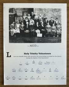 Port Melbourne Historical & Preservation Society
Photograph - Soup kitchen volunteers, Holy Trinity Anglican Church, Port Melbourne, 1933
... J K TAYLOR, Mrs MILLER, ?, Nick HILLYER, Mrs N HILLYER Front row L-R: BAMFORD, Irene LEWIS?, BOYDEN, WILSON, Mrs TAYLOR, Mrs COTTON, ?, ?, SMITH, Mrs MATHERS...J K TAYLOR, Mrs MILLER, ?, Nick HILLYER, Mrs N HILLYER Front row L-R: BAMFORD, Irene LEWIS?, BOYDEN, WILSON, Mrs TAYLOR, Mrs COTTON, ?, ?, SMITH, Mrs MATHERS ...Original has been kept by the family since 1933 and was loaned to us August 1998 for copying.Colour lasercopy from black and white mounted original loaned by Ken TURNER, of 1933 photo of Holy Trinity volunteers (ladies and two men) who ran the soup kitchen in the hall. Ken's mum, Lily, second from left in back row. Taken beside the vicarage. Hand lettered, partly legible sign at their feet indicates they are 'Helpers - Holy Trinity, Port Melbourne'. Mrs MILLER, to the right of Rev J K TAYLOR was a Tobacconist in Bay Street. Back row L-R: FOOKES, Lily TURNER, Harry BONE?, Ruth PARKINSON, Sarah EDWARDS, ? Second row L-R: Daisy WHITING, Mrs BONE, M M PREST, Rev J K TAYLOR, Mrs MILLER, ?, Nick HILLYER, Mrs N HILLYER Front row L-R: BAMFORD, Irene LEWIS?, BOYDEN, WILSON, Mrs TAYLOR, Mrs COTTON, ?, ?, SMITH, Mrs MATHERSfookes, lily turner, harry bone?, ruth parkinson, sarah edwards, religion - anglican (holy trinity), depression, daisy whiting, mrs bone, m m prest, mrs miller, nick hillyer, mrs n hillyer, j k taylor, bamford, boyden, wilson, mrs taylor, mrs cotton, smith, mrs mathers, irene lewis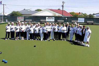 Sunshine and District Historical Society Incorporated
Photograph - Sunshine City Ladies Bowling Club Celebrating 25 years, 2003
... Sutton, J. Lamont, Pidwell, G. Mathers, L. Maxwell 2144.29 - Sunshine City Ladies Bowling Club Celebrating 25 years - Joan Sutton 2144.30 - Sunshine City Ladies Bowling Club Celebrating 25 years - Bowlers Enjoying The Meal 2144.31 - Sunshine City Ladies Bowling Club Celebrating 25 years - J. ...Sutton, J. Lamont, Pidwell, G. Mathers, L. Maxwell 2144.29 - Sunshine City Ladies Bowling Club Celebrating 25 years - Joan Sutton 2144.30 - Sunshine City Ladies Bowling Club Celebrating 25 years - Bowlers Enjoying The Meal 2144.31 - Sunshine City Ladies Bowling Club Celebrating 25 years - J. ...Sunshine City Ladies Bowling Club Celebrating 25 years 12/10/2003 2144.01 - Sunshine City Ladies Bowling Club Celebrating 25 years - Ladies On Bowling Green 2144.02 - Sunshine City Ladies Bowling Club Celebrating 25 years - Club Rooms 2144.03 - Sunshine City Ladies Bowling Club Celebrating 25 years - Bowlers On Green 2144.04 - Sunshine City Ladies Bowling Club Celebrating 25 years - Bowlers On Green 2144.05 - Sunshine City Ladies Bowling Club Celebrating 25 years - May Sherwood 2144.06 - Sunshine City Ladies Bowling Club Celebrating 25 years - Norma Mill 2144.07 - Sunshine City Ladies Bowling Club Celebrating 25 years - Marion Norris 2144.08 - Sunshine City Ladies Bowling Club Celebrating 25 years - VIP Table Setting 2144.09 - Sunshine City Ladies Bowling Club Celebrating 25 years - VIP Table 2144.10 - Sunshine City Ladies Bowling Club Celebrating 25 years - M. Dickson, M. Norris, J. Adams, E. Stafford, V. Coughlan 2144.11 - Sunshine City Ladies Bowling Club Celebrating 25 years - E. Brennan, E. MacKender, M. McDonald 2144.12 - Sunshine City Ladies Bowling Club Celebrating 25 years - Myrtle Baylis 2144.13 - Sunshine City Ladies Bowling Club Celebrating 25 years - L. Gust, B. Davis, M. Sherwood 2144.14 - Sunshine City Ladies Bowling Club Celebrating 25 years - D. Vines, J. Whelan, E. MacKender, B. McIntyre 2144.15 - Sunshine City Ladies Bowling Club Celebrating 25 years - Linda Mullin 2144.26 - Sunshine City Ladies Bowling Club Celebrating 25 years - Gloria Mathers 2144.27 - Sunshine City Ladies Bowling Club Celebrating 25 years - Carol Pidwell, Joan Lamont 2144.28 - Sunshine City Ladies Bowling Club Celebrating 25 years - J. Adams, V. Coughlan, J. Sutton, J. Lamont, Pidwell, G. Mathers, L. Maxwell 2144.29 - Sunshine City Ladies Bowling Club Celebrating 25 years - Joan Sutton 2144.30 - Sunshine City Ladies Bowling Club Celebrating 25 years - Bowlers Enjoying The Meal 2144.31 - Sunshine City Ladies Bowling Club Celebrating 25 years - J. Sutton, Joan Lamont, Joan Adams 2144.32 - Sunshine City Ladies Bowling Club Celebrating 25 years - Joan Sutton 2144.33 - Sunshine City Ladies Bowling Club Celebrating 25 years - Barb Davis 2144.34 - Sunshine City Ladies Bowling Club Celebrating 25 years - Elsie Brennan Doing Table Inspection 2144.35 - Sunshine City Ladies Bowling Club Celebrating 25 years - Groups Sitting At Tables 2144.36 - Sunshine City Ladies Bowling Club Celebrating 25 years - June Whelan, Gwen Carpenter, Jan Haygarth 2144.37 - Sunshine City Ladies Bowling Club Celebrating 25 years - M. Dickson, J. Vanatti, B. Duncan, D. Williams, J. Borg 2144.38 - Sunshine City Ladies Bowling Club Celebrating 25 years - Groups Sitting At Tables 2144.39 - Sunshine City Ladies Bowling Club Celebrating 25 years - Groups Sitting At Tables 2144.40 - Sunshine City Ladies Bowling Club Celebrating 25 years - Groups Sitting At Tables 2144.41 - Sunshine City Ladies Bowling Club Celebrating 25 years - Joyce Williams, Glad Dawsonm Thelma McMaster 2144.42 - Sunshine City Ladies Bowling Club Celebrating 25 years - Diane Monks, Elise Brennan, Joan Treloar 2144.43 - Sunshine City Ladies Bowling Club Celebrating 25 years - Mavis Baddeley 2144.44 - Sunshine City Ladies Bowling Club Celebrating 25 years - Nina Caruana, Judith Casey, Enid MacKender, Judy Pimblott 2144.45 - Sunshine City Ladies Bowling Club Celebrating 25 years - Norma Mill 2144.46 - Sunshine City Ladies Bowling Club Celebrating 25 years - Ellen Fleming, Glendys Azzopardi 2144.47 - Sunshine City Ladies Bowling Club Celebrating 25 years - Glendys Azzopardi, Maude Cameron, Adele Brown 2144.48 - Sunshine City Ladies Bowling Club Celebrating 25 years - Enid MacKender 2144.49 - Sunshine City Ladies Bowling Club Celebrating 25 years - Joan Treloar, Nina Caruana 2144.50 - Sunshine City Ladies Bowling Club Celebrating 25 years - Jessie Shears 2144.51 - Sunshine City Ladies Bowling Club Celebrating 25 years - Ladies standing At Tables 2144.52 - Sunshine City Ladies Bowling Club Celebrating 25 years - Dot Voss, Adele Brown, Carmel Keating 2144.53 - Sunshine City Ladies Bowling Club Celebrating 25 years - Lorna Stainer 2144.54 - Sunshine City Ladies Bowling Club Celebrating 25 years - Adele Brown 2144.55 - Sunshine City Ladies Bowling Club Celebrating 25 years - Dor Voss, Marj 2144.56 - Sunshine City Ladies Bowling Club Celebrating 25 years - B. Duncan, C. Keating, J. Vanotti, J. Haygarth 2144.57 - Sunshine City Ladies Bowling Club Celebrating 25 years - Dor Williams, Mary 2144.58 - Sunshine City Ladies Bowling Club Celebrating 25 years - Joyce Cleeve, Maureen McDonald 2144.59 - Sunshine City Ladies Bowling Club Celebrating 25 years - Joan Aitken, Wendy Dyson 2144.60 - Sunshine City Ladies Bowling Club Celebrating 25 years - Elsie Brennan, Joyce Cleeve 2144.61 - Sunshine City Ladies Bowling Club Celebrating 25 years - Gwen Carpenter 2144.62 - Sunshine City Ladies Bowling Club Celebrating 25 years - Diane Monks 2144.63 - Sunshine City Ladies Bowling Club Celebrating 25 years - Ian Bowler 2144.64 - Sunshine City Ladies Bowling Club Celebrating 25 years - Clive Brown 2144.65 - Sunshine City Ladies Bowling Club Celebrating 25 years - Brenda Peace 2144.66 - Sunshine City Ladies Bowling Club Celebrating 25 years - Joan Treloar 2144.67 - Sunshine City Ladies Bowling Club Celebrating 25 years - Nina Caruana 2144.68 - Sunshine City Ladies Bowling Club Celebrating 25 years - Doreen Vines 2144.69 - Sunshine City Ladies Bowling Club Celebrating 25 years - Elsie Brennan 2144.70 - Sunshine City Ladies Bowling Club Celebrating 25 years - Genid Arnastauskas 2144.71 - Sunshine City Ladies Bowling Club Celebrating 25 years - Terry Norris, Ian Bowker, Clive Brown 2144.72 - Sunshine City Ladies Bowling Club Celebrating 25 years - Barry Warburton, Veronica Coughlan, George Bryce 2144.73 - Sunshine City Ladies Bowling Club Celebrating 25 years - T. Beachley, A. Gust, B. Brooking, D. Mill, J. Bayana 2144.74 - Sunshine City Ladies Bowling Club Celebrating 25 years - Ernie Mullin, Joan Sutton, Jack Pidwell 2144.75 - Sunshine City Ladies Bowling Club Celebrating 25 years - Judy Pimblott, Judith Veering 2144.76 - Sunshine City Ladies Bowling Club Celebrating 25 years - Bowlers On Green 2144.77 - Sunshine City Ladies Bowling Club Celebrating 25 years - Lorraine Kutcher 2144.78 - Sunshine City Ladies Bowling Club Celebrating 25 years - Group Shot At Table 2144.79 - Sunshine City Ladies Bowling Club Celebrating 25 years - Carol Hawkins 2144.80 - Sunshine City Ladies Bowling Club Celebrating 25 years - Mavis Baddeley, Mary De Haas 2144.81 - Sunshine City Ladies Bowling Club Celebrating 25 years - Cake 2144.82 - Sunshine City Ladies Bowling Club Celebrating 25 years - Margaret Dickson's Orchids 2144.83 - Sunshine City Ladies Bowling Club Celebrating 25 years - Table Setups 2144.84 - Sunshine City Ladies Bowling Club Celebrating 25 years - Club Rooms 2144.85 - Sunshine City Ladies Bowling Club Celebrating 25 years - Ladies On Bowling Green 2144.86 - Sunshine City Ladies Bowling Club Celebrating 25 years - VIP Table Decorations 2144.87 - Sunshine City Ladies Bowling Club Celebrating 25 years - Cake 2144.88 - Sunshine City Ladies Bowling Club Celebrating 25 years - Cutting The Cake 2144.89 - Sunshine City Ladies Bowling Club Celebrating 25 years - Marion Norris 2144.90 - Sunshine City Ladies Bowling Club Celebrating 25 years - Group Shot At VIP Table 2144.91 - Sunshine City Ladies Bowling Club Celebrating 25 years - V.L.B.A. President 2144.92 - Sunshine City Ladies Bowling Club Celebrating 25 years - Joan Adams, Elaine Stafford 2144.93 - Sunshine City Ladies Bowling Club Celebrating 25 years - Margaret Dickson 2144.94 - Sunshine City Ladies Bowling Club Celebrating 25 years - Joan Sutton, Joan Lamont, Carol Pidwell, Gloria Mathers, Linda Mullin, Joan Adams 2144.95 - Sunshine City Ladies Bowling Club Celebrating 25 years - Marion Norris, Joan Adams 2144.96 - Sunshine City Ladies Bowling Club Celebrating 25 years - Marion Norris, Elaine Stafford 2144.97 - Sunshine City Ladies Bowling Club Celebrating 25 years - Marion Norris 2144.98 - Sunshine City Ladies Bowling Club Celebrating 25 years - Ladies On Bowling Green 2144.99 - Sunshine City Ladies Bowling Club Celebrating 25 years - Table Setupssunshine bowling club, club, memento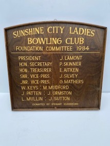 Sunshine and District Historical Society Incorporated
Honour Board - Sunshine City Ladies Bowling Club Foundation Committee 1984 Honour Board
... Vice-Pres. J. Silvey, Jnr. Vice-Pres. G. Mathers, W. Keys, M. Mudford, J. ...Vice-Pres. J. Silvey, Jnr. Vice-Pres. G. Mathers, W. Keys, M. Mudford, J. ...Wooden honour board , rectangle in shape with curved top with golden letteringSunshine City Ladies Bowling Club Foundation Committee 1984|President J. Lamot, Hon. Secretary P. Skinner, Hon. Treasurer E. Aitken, Snr. Vice-Pres. J. Silvey, Jnr. Vice-Pres. G. Mathers, W. Keys, M. Mudford, J. Ormston, J. Sutton|Donated by Stewart Cuddefordsunshine ladies bowling club, bowling, memento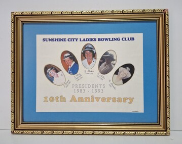 Sunshine and District Historical Society Incorporated
Photograph - Sunshine City Ladies Bowling Club Presidents 1983 - 1993 10th Anniversary Photo, T. Hodges
... Lamont 1984-1986, J. Silvey 1986-1988 & 1990-1991, G. Mathers 1988-1990, L. Mullin 1991-1993 & B. ...Lamont 1984-1986, J. Silvey 1986-1988 & 1990-1991, G. Mathers 1988-1990, L. Mullin 1991-1993 & B. ...Sunshine City Ladies Bowling Club Presidents 1983 - 1993 10th Anniversary L. Lamont 1984-1986, J. Silvey 1986-1988 & 1990-1991, G. Mathers 1988-1990, L. Mullin 1991-1993 & B. Alexander 1993sunshine ladies bowling club, bowling, memento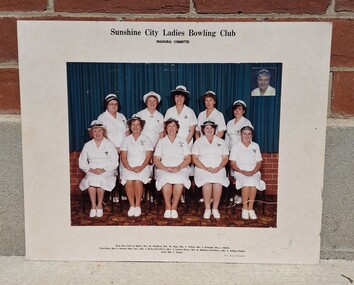 Sunshine and District Historical Society Incorporated
Photograph - Sunshine City Ladies Bowling Club Inaugural Committee Photo, Barry Searle Photography
... Silvey (Vice-Pres), Mrs J. Lamont (Pres), Mrs G. Mathers (Vice-Pres), Mrs E. Aitken (Treas) & Mrs J. ...Silvey (Vice-Pres), Mrs J. Lamont (Pres), Mrs G. Mathers (Vice-Pres), Mrs E. Aitken (Treas) & Mrs J. ...Sunshine City Ladies Bowling Club Inaugural Committee Mrs M. Mudford, Mrs W. Keyes, Mrs J. Patten, Mrs J. Ormston, Mrs L. Mullin, Mrs P. Skinner (Hon. Sec.), Mrs J. Silvey (Vice-Pres), Mrs J. Lamont (Pres), Mrs G. Mathers (Vice-Pres), Mrs E. Aitken (Treas) & Mrs J. Suttonsunshine ladies bowling club, bowling, memento Uniting Church Archives - Synod of Victoria
Artwork, other - Illuminated art work, Rev Alexander Yule MA presentation art work
... Mather...Adam Kennedy...Maggie Adam...H. S. Richardson...Lily V. Grant...David J...Reid Robertson John Mather Adam Kennedy Maggie Adam H. S. Richardson Lily V. Grant David J. Scott M. ...This was presented to the Rev Yule on 22 February 1907. Alexander Yule was born in 1830 in Aberdeenshire, Scotland becoming licenced in the Free Church of Scotland in 1854. He came to Australia in 1870 where he became Minister of Erskine church, Carlton. In 1892 College Church Parkville was established by members of the Erskine congregation. In 1891 he was moderator of Victoria. He died on 18 April 1907.Framed illuminated composite presentation art work which has illuminated text, the Presbyterian symbol of the burning bush, a photograph and illustrations of the College Church, Ormond College, University of Melbourne. It is signed by ten people.presbyterian miniter rev alexander yule ma, r. johnston smith, m. reid robertson, john mather, adam kennedy, maggie adam, h. s. richardson, lily v. grant, david j. scott, m. e. downes, j. downes., the college church parkville, alexander yule 1830-1907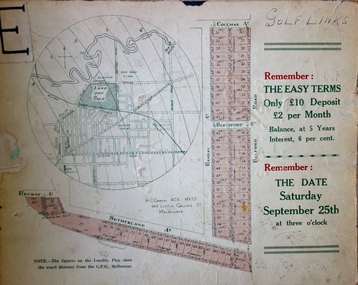 Kew Historical Society Inc
Plan - Subdivision Plan, H C Crouch, Old Golf Links Estate, 1930s
... Old Golf Links Estate Plan Subdivision Plan H C Crouch J R Mathers & McMillan ...The land in North Kew between the Outer Circle Railway and the River Yarra was released in sections. This release included 80 lots. Most of this area was released during the Depression years in the early 1930s.Subdivision plans are historically important documents used as evidence of the growth of suburbs in Australia. They frequently provide information about when the land was sold on which a built structure was subsequently constructed as well as evidence relating to surveyors and real estate and financial agents. The numerous subdivision plans in the Kew Historical Society's collection represent working documents, ranging from the initial sketches made in planning a subdivision to printed plans on which auctioneers or agents listed the prices for which individual lots were sold. In a number of cases, the reverse of a subdivision plan in the collection includes a photograph of a house that was also for sale by the agent. These photographs provide significant heritage information relating house design and decoration, fencing and household gardens.One part of a massive subdivision of the Old Golf Links Estate in North Kew of 80 allotments bordering Sutherland Avenue, Ramsay Avenue, Belford Road, Beresford Street and Coleman Avenue. Inset on the plan at the top left, the route of the Outer Circle Railway is clearly marked. The Kew Golf Links is identified in its current location. The land on which Greenacres Golf Club was to be constructed is at this time marked as ‘Recreation Ground’. The ‘new bridge’ over the Yarra at Burke Road is also marked on the inset map. The Plan identifies the surveyor (sic) H.C. Crouch BCE MVIS, 443 Little Collins St., Melbourne. The date of the subdivision auction sale in identified as Saturday September 25th at three o'clock.Annotations: "E" top left. "Golf Links" top right. Lots 73-76 ticked and listed as "6" poundssubdivisions -- kew (vic.), old golf links estate