Showing 106 items matching " mather r."
-
 Linton and District Historical Society Inc
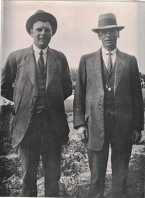
Photograph, Jim Mather and Dave Nicol
... "L Jim Mather R Dave Nicol."...Linton and District Historical Society Inc 69 Sussex Street Linton 3360 goldfields Jim Mather Dave Nicol "L Jim Mather R Dave Nicol." Black and white copy of original photograph showing two men standing next to each other, both wearing dark suits, white shirt, tie and hats. man on the right has a fob chain showing. ...Black and white copy of original photograph showing two men standing next to each other, both wearing dark suits, white shirt, tie and hats. man on the right has a fob chain showing. Photo taken outside."L Jim Mather R Dave Nicol."jim mather, dave nicol -
 Glen Eira Historical Society
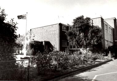
Article - CAULFIELD CENTRAL RSL
... ... Mather R....Jellett L. Lesar H. Mather R. Nelson N. Ratford D. Rowe P. Turner W. ...This file contains six items pertaining to the Caulfield Central RSL: 1/A page to which is attached a black-and-white photograph (date, source and photographer unspecified) of the Caulfield Central RSL, outlying garden and Australian flag. Some writing on the rear identifies the subject. 2/A typewritten letter, (1 page) dated 1946 (no date more specific than that specified), from the Chairman & Honorary Treasurer of the Caulfield Central RSL Appeal Committee (name unspecified) to the Mayor of Caulfield (name also unspecified), imploring the latter for a donation of $20,000 dollars for purposes of constructing a Memorial Hall to eulogize servicemen killed during WWII. Some rough working notes on rear side. 3/A flyer, undated (although presumably published in 1950), printed by Peter Isaacson Pty. Ltd., advertising a concert presented by the Ugly Ugly Man (Frank M. Beard) and the Malvern Tramways’ Harmonica Band to be held at Caulfield Town Hall on 06/06/1950 to assist the Welfare Funds of the Caulfield Central RSL and the Sailors, Soldiers and Airmen’s Mothers’ Association. Also contains an advertisement for a drapery business called Tallents. 4/The annual report of the Caulfield Central RSL, for the period 1952 – 1953. Contains announcements of the annual general meeting and annual elections, the President’s report (in which he principally discusses the club’s charity work and sporting activities), the subcommittee staff roster, the sportsmen’s honour roll, the annual accounts (e.g. balance sheet, income & expenditure statement) and the roster of nominees for office in the committee of management election. 5/A typewritten letter, (1 page) dated 26/11/1982, from Max Brian Blair, Treasurer of the Caulfield Central RSL, to Mr. R. Ballantyne, Secretary of the Caulfield Historical Society, thanking him for his donation to the RSL. 6/A photocopy of an article titled ‘RSL pays $30,000 to buy off objector’ (from the Sunday Herald, by Mary-Anne Toy, dated 16/09/1990), about the Caulfield Central RSL paying local resident Mr. Chris White to withdraw his objection to the RSL’s intention to re-allocate its clubrooms, and the consequent response of the relevant authorities.Black and white photographic print of Caulfield Central RSL buildingOn reverse, PIC B - 5 - CONTACT - RSL BUILDING - CONTACT 28/4/88 - 100% - HAWTHORN ROAD CAULFIELDcaulfield, caulfield central returned servicemen league (rsl), ex-service organisations, clubs and associations, returned servicepeople, armed forces, soldiers, aged people, senior citizens centres, mayors, city of caulfield, war memorials, blamey thomas general sir, white t. w. group capt., gullett h. b. major, beaurepaire frank sir m.l.c., kennedy j. a. m.l.c., warner a. g. m.l.c., michaelis archie m.l.a., dennett a. h. lt.-col. m.l.a., don john capt. m.l.a., reid h. squire m.l.a., brooks w. r. cr., packer j. t. cr., parton e. m. cr., prior p. l. cr., morris t. w. cr., sinclair a. j. g. cr., sims h. e. cr., smith h. c. h. cr., smith james e. cr., tyers s. w. cr., webster harold cr., yorston j. s. cr., briggs r. jas., disney j. s., donath h., llewellyn evans, goddard s. a. padre, lynch p. j., nilsen oliver j. cr., pidd padre a. t., robinson norman, reece harold j., wootton harold s., wallace gordon w., nelson harold g., halls, concerts, musical events and activities, fundraising events, bands, musical ensembles, sailors soldiers and airmen’s mothers’ association, ‘the ugly ugly man’, beard frank m., malvern tramways harmonica band the, caulfield town hall, tallents, drapers, glenhuntly road, glen huntly road, elsternwick, peter isaacson pty. ltd melbourne, annual reports, financial documents, fisher s. w., finch f., williams f., salmon j. e., mallyon v. k., woods w., mayne t. v., lanyon r. j., rowney w. p., williams j. d., pepper e., bathurst t., patterson r., nuzum e. j., phillips e. v., turner g., hawthorn road, byrne l. j., eva a. r., bunny c. l., hoy c. a., orken a., hiam s. f., rawson n. l., coleman g. h., cohen a. s., mason j., goode l. p., nelson h. g., crosbie m. r., mcsweeney t., westley g. de v., greeves c. g., festivals and celebrations, community services, social services, service clubs, ladies auxiliary, returned servicewomen’s section, blamey house, social sub-committee, sport, sporting clubs, tennis, golf, billiards, table tennis, lawn bowls, thompson peter, cricket, children’s health bureau, family welfare bureau, buley doug mr., tomlins m. i., lang a. r., kendall h. i., ford c., munro w., gordon h., rowe s., green j. h., o’brien j., ring t., anderson g. j., croft r. m., jones p. j., la cerf g., roper i., lawrence f., eustace r. c., hanley a., moore a., strachan w. d., gilbert w. f., blair m. r., scriven e. g., miller j. l., hosking b. e., cheeseman r. n., summers s., croy l. w., mclatchie s., williams stan, hattersly cliff, day alf, rawson noel, johnson alby, banham bill, kersey b., williams s., jones a., witten f., waters r., dash r., meldrum i., grant j., haggar l., nightingale n., hallett r., somers r., young g., rawson n., croft r., barton m., o’grady w., cooper p., manton j., sutcliffe a., maver a., challender d., hunt a., parrott e., leicester j., westwood a., rae alex, smith harry, forbes jimmy, johnson jack, higgins w., fink s., hall s., ross m., anderson h., fleming j., bottoms a., peek e., stark j., mathews e., gursansky l., morres r., alenson j., holland i., wallace p., craig h., lucas j., smith h., bretel l., berryman p., reid a., swann j., tully f., henderson g., fields w., johnson j., gloster p., tennat j., boyd a., butterworth k., chapman k., curran j., elkington a. b., evans w., mckenzie d. a., nicol a. b., thompson w., wanliss t. w., watson g. j., williams g., yeomans p., mcgowan h., o’connor k., atherton r., batson s. s., bull e., fletcher a., gorman s. c., hall w., jellett l., lesar h., mather r., nelson n., ratford d., rowe p., turner w. j., wehsack f., williams s. c., wilson a., carter w., forbes i., purvis l., datson r., jackson e., wolstencroft w., smith c., mitchell r., harward j., gillespie ray, hill wally, parkinson w. g., greeves colin mr., water stan mr., selleck f. p., luckins l., andrews f., young v. l., king e. j., mccutcheon j. o., grenfell d. j., hurley c., shand a. r., yeates l., hogue h., mather j., wardrop j., lyons a. m., ross a. r., bradley t., walker r. n., cox f. c., mornane j. s., fletcher a. e., mcneil j. g., rose n., lyons l. j., trevorrow g., wright d. e., walker r., maxwell j., hutchinson j. c., mclean r., caulfield historical society, ballantyne r. mr., blair max brian, toy mary-anne, ruxton bruce mr., administrative appeals tribunal, caulfield city council, white chris mr., northcote avenue, independent church of australia, marsden ian mr., mccutcheon mr -
 Kew Historical Society Inc
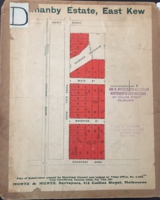
Plan - Subdivision Plan, J R Mathers & McMillan, Normanby Estate, c.1913
... These early plans were assembled by a local firm, Jas R Mather & McMillan, which had an office in Cotham Road. ...R. Mathers / Estate & Financial Agent / Cotham Road / Kew"....R. Mathers / Estate & Financial Agent / Cotham Road / Kew". ...The Kew Historical Society's map collection includes a substantial number of real estate subdivision plans, mainly of Kew but also of surrounding suburbs in Melbourne. Most of the subdivision plans date from the 1920s and 1930s when the districts old homes and local farmland were being split up to accommodate residential growth in the postwar period. These early plans were assembled by a local firm, Jas R Mather & McMillan, which had an office in Cotham Road. Many of the plans, and sometimes photos, were annotated by the agents.Subdivision plans are historically important documents used as evidence for the growth of suburbs in Australia. They frequently provide information about when the land was sold as well as evidence relating to surveyors and real estate and financial agents. The numerous subdivision plans in the Kew Historical Society's collection represent working documents, ranging from the initial sketches made in planning a subdivision to printed plans on which auctioneers or agents listed the prices for which individual lots were sold. In a number of cases, the reverse of a subdivision plan in the collection includes a photograph of a house that was also for sale by the agent. These photographs provide significant heritage information relating house design and decoration, fencing and household gardens.The photograph may also be aesthetically significant depending on the importance of the photographic atelier.The Normanby Estate, which was adjacent to Normanby Road, Kew East, included thirty-one lots for sale. Streets on the subdivision plan include Adeney Avenue, Park Hill Road, Normanby Road, Weir Street and Wharton Street. Cotham Road and its tramway are shown nearby. The plan is interesting as it shows Wharton Street, named after the architect and town planner George Wharton, who was the first chairman of the Municipality of Kew. The street was to later be renamed Cecil Street. Also shown are proposed ‘Municipal Gardens’ where Parkhill Drive is now located."D" in top left corner. Stamped auctioneers contact details: "Jas. R. Mathers & Son & McMillan / Auctioneer & Land Salesmen, / 271 Collins Street / Melbourne" and Jas. R. Mathers / Estate & Financial Agent / Cotham Road / Kew".weir street - kew, wharton street - kew, normanby road - kew, cotham road - kew, municipal gardens - kew, park hill parkhill road - kew, braemar - kew, subdivision plans - kew -
 Kew Historical Society Inc
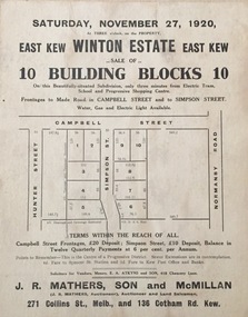
Plan - Subdivision Plan, Winton Estate, East Kew : Sale of 10 Building Blocks, 1920
... These early plans were assembled by a local firm, Jas R Mather & McMillan, which had an office in Cotham Road. ...The estate was auctioned by Jas. R. Mathers, Son and McMillan. ...The estate was auctioned by Jas. R. Mathers, Son and McMillan. Winton Estate, East Kew : Sale of 10 Building Blocks Plan Subdivision Plan Jas R Mathers Son & McMillan ...The Kew Historical Society's map collection includes a substantial number of real estate subdivision plans, mainly of Kew but also of surrounding suburbs in Melbourne. Most of the subdivision plans date from the 1920s and 1930s when the districts old homes and local farmland were being split up to accommodate residential growth in the postwar period. These early plans were assembled by a local firm, Jas R Mather & McMillan, which had an office in Cotham Road. Many of the plans, and sometimes photos, were annotated by the agents.Subdivision plans are historically important documents used as evidence for the growth of suburbs in Australia. They frequently provide information about when the land was sold as well as evidence relating to surveyors and real estate and financial agents. The numerous subdivision plans in the Kew Historical Society's collection represent working documents, ranging from the initial sketches made in planning a subdivision to printed plans on which auctioneers or agents listed the prices for which individual lots were sold. In a number of cases, the reverse of a subdivision plan in the collection includes a photograph of a house that was also for sale by the agent. These photographs provide significant heritage information relating house design and decoration, fencing and household gardens.The photograph may also be aesthetically significant depending on the importance of the photographic atelier.Subdivision plan for the so-called Winton Estate in East Kew. The Estate comprised 10 lots facing Simpson Street and Campbell Street. The estate was auctioned by Jas. R. Mathers, Son and McMillan. campbell street, simpson street, hunter street, normanby road - kew, subdivision plans - east kew, subdivision plans - kew -
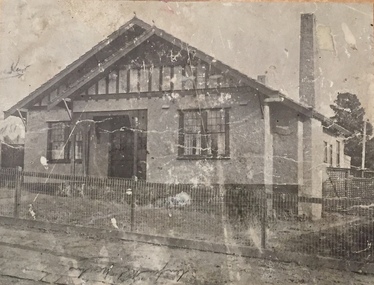
![7 Roomed Brick [villa]; Modern Conveniences](/media/collectors/550653872162f11fb04854aa/items/59ec3da221ea690fdc4ba793/item-media/59ec3ee521ea690fdc4d0c37/item-fit-380x285.jpg?cb=6) Kew Historical Society Inc
Kew Historical Society IncPhotograph - 7 Roomed Brick [villa]; Modern Conveniences, 1920s
... These early plans were assembled by a local firm, Jas R Mather & McMillan, which had an office in Cotham Road. ...A professionally produced photograph for a local real estate agent, probably Jas. R. Mathers, Son & McMillan. The photograph is of a Federation-era bungalow, in Kew. ...These early plans were assembled by a local firm, Jas R Mather & McMillan, which had an office in Cotham Road. ...The Kew Historical Society's map collection includes a substantial number of real estate subdivision plans, mainly of Kew but also of surrounding suburbs in Melbourne. Most of the subdivision plans date from the 1920s and 1930s when the districts old homes and local farmland were being split up to accommodate residential growth in the postwar period. These early plans were assembled by a local firm, Jas R Mather & McMillan, which had an office in Cotham Road. Many of the plans, and sometimes photos, were annotated by the agents.Subdivision plans are historically important documents used as evidence for the growth of suburbs in Australia. They frequently provide information about when the land was sold as well as evidence relating to surveyors and real estate and financial agents. The numerous subdivision plans in the Kew Historical Society's collection represent working documents, ranging from the initial sketches made in planning a subdivision to printed plans on which auctioneers or agents listed the prices for which individual lots were sold. In a number of cases, the reverse of a subdivision plan in the collection includes a photograph of a house that was also for sale by the agent. These photographs provide significant heritage information relating house design and decoration, fencing and household gardens.The photograph may also be aesthetically significant depending on the importance of the photographic atelier.A professionally produced photograph for a local real estate agent, probably Jas. R. Mathers, Son & McMillan. The photograph is of a Federation-era bungalow, in Kew. The photo is on the reverse of a subdivision plan for the Normanby Heights Estate, Kew.The mount on which the photograph is placed includes: "Kew. 1 minute to tram. Good Position. / 7 roomed brick. Modern conveniences. / Land 60 x 135. 1100 pounds"real estate photographs, houses - kew, federation architecture -
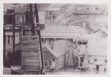 Clunes Museum
Photograph, PORT PHILLIP MINE
... FLOOD WATER SURROUNDING BASE OF BUILDINGS R. MATHER BUILDING VISIBLE...FLOOD WATER SURROUNDING BASE OF BUILDINGS R. MATHER BUILDING VISIBLE PORT PHILLIP MINE Photograph PHOTOGRAPH ...BLACK AND WHITE PHOTOGRAPH - SECTION PORT PHILLIP MINE. FLOOD WATER SURROUNDING BASE OF BUILDINGS R. MATHER BUILDING VISIBLEphotographs, mining, port phillip mine -
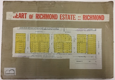 Kew Historical Society Inc
Plan - Subdivision Plan, J R Mathers & McMillan, Heart of Richmond Estate : Richmond, 1928
... Title Certificate Vol.2381, Folio 476130 Phillips, Fox & Masel, 440 Little Collins Street, Melbourne (Local estate agent: Jas. R. Mathers & McMIllan, 136 Cotham Road, Kew)...Area includes Johnson Street, Victoria Street, Kennedy Street, Cole Street, Hollick Street, Bennett Street Heart of Richmond Estate : Richmond Plan Subdivision Plan J R Mathers & McMillan ..."In 1928 the land on the east side of Johnson Street was subdivided in 60 lots for the ‘Heart of Richmond Estate’. The houses in the subdivision, along the east side of Johnson Street, and in the newly created Hollick, Cole and Kennedy streets were constructed from 1928 to 1937." (Source: City of Yarra Heritage Gaps Review One 2013)Portion of subdivision plan pasted on to cardboard. Area includes Johnson Street, Victoria Street, Kennedy Street, Cole Street, Hollick Street, Bennett StreetTitle Certificate Vol.2381, Folio 476130 Phillips, Fox & Masel, 440 Little Collins Street, Melbourne (Local estate agent: Jas. R. Mathers & McMIllan, 136 Cotham Road, Kew)subdivision plans - richmond (vic.), heart of richmond estate -
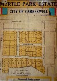 Kew Historical Society Inc
Plan - Subdivision Plan, Myrtle Park Estate, City of Camberwell, 1916
... It is believed that the majority of the plans were gifted to the Society by persons connected with the real estate firm - J. R. Mathers and McMillan, 136 Cotham Road, Kew. ...Myrtle Park Estate, City of Camberwell Plan Subdivision Plan J R Mathers & McMillan ...The Kew Historical Society collection includes almost 100 subdivision plans pertaining to suburbs of the City of Melbourne. Most of these are of Kew, Kew East or Studley Park, although a smaller number are plans of Camberwell, Deepdene, Balwyn and Hawthorn. It is believed that the majority of the plans were gifted to the Society by persons connected with the real estate firm - J. R. Mathers and McMillan, 136 Cotham Road, Kew. The Plans in the collection are rarely in pristine form, being working plans on which the agent would write notes and record lots sold and the prices of these. The subdivision plans are historically significant examples of the growth of urban Melbourne from the beginning of the 20th Century up until the 1980s. A number of the plans are double-sided and often include a photograph on the reverse. A number of the latter are by noted photographers such as J.E. Barnes.The ‘Myrtle Park Estate’ was a subdivision bounded by Victoria Road (now Lansdowne Street), Buchanan Avenue and Dight Avenue. Other streets that were created by the subdivision included Eurolie Street, Boorahman Street and Moody Street (now Sylvan Street). The Estate took its name from Myrtle Park (later changed to Macleay Park), which had been created in 1923 by Camberwell Council. The Park adjoined the southeast corner of the new subdivision. The Estate included 74 regular allotments characterised by narrow frontages and long blocks. Confusion may have greeted prospective purchasers as the Estate was advertised in the daily newspapers as being in East Kew, rather than in Camberwell, where it was at that stage located.subdivision plans - balwyn, myrtle park estate - camberwell [surrey hills] -
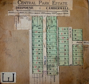 Kew Historical Society Inc
Plan - Subdivision Plan, Central Park Estate, Deepdene - Camberwell, 1923
... It is believed that the majority of the plans were gifted to the Society by persons connected with the real estate firm - J. R. Mathers and McMillan, 136 Cotham Road, Kew. ...Central Park Estate, Deepdene - Camberwell Plan Subdivision Plan J R Mathers & McMillan ...The Kew Historical Society collection includes almost 100 subdivision plans pertaining to suburbs of the City of Melbourne. Most of these are of Kew, Kew East or Studley Park, although a smaller number are plans of Camberwell, Deepdene, Balwyn and Hawthorn. It is believed that the majority of the plans were gifted to the Society by persons connected with the real estate firm - J. R. Mathers and McMillan, 136 Cotham Road, Kew. The Plans in the collection are rarely in pristine form, being working plans on which the agent would write notes and record lots sold and the prices of these. The subdivision plans are historically significant examples of the growth of urban Melbourne from the beginning of the 20th Century up until the 1980s. A number of the plans are double-sided and often include a photograph on the reverse. A number of the latter are by noted photographers such as J.E. Barnes.An agent’s board on which parts of an advertisement for the Central Park Estate have been pasted. [The State Library of Victoria holds a complete plan]. Whereas the original plan included black and white photographs and effusive prose about the virtues of the Estate, the item in our collection includes only the actual blocks. The agent has annotated particular blocks to indicate that they have been sold.subdivision plans - deepdene - camberwell, central park estate -
 Kew Historical Society Inc
Photograph - Brick and Stucco Bungalow, J E Barnes, c.1920
... These early plans were assembled by a local firm, Jas R Mather & McMillan, which had an office in Cotham Road. ...These early plans were assembled by a local firm, Jas R Mather & McMillan, which had an office in Cotham Road. ...The Kew Historical Society's map collection includes a substantial number of real estate subdivision plans, mainly of Kew but also of surrounding suburbs in Melbourne. Most of the subdivision plans date from the 1920s and 1930s when the districts old homes and local farmland were being split up to accommodate residential growth in the postwar period. These early plans were assembled by a local firm, Jas R Mather & McMillan, which had an office in Cotham Road. Many of the plans, and sometimes photos, were annotated by the agents.Subdivision plans are historically important documents used as evidence for the growth of suburbs in Australia. They frequently provide information about when the land was sold as well as evidence relating to surveyors and real estate and financial agents. The numerous subdivision plans in the Kew Historical Society's collection represent working documents, ranging from the initial sketches made in planning a subdivision to printed plans on which auctioneers or agents listed the prices for which individual lots were sold. In a number of cases, the reverse of a subdivision plan in the collection includes a photograph of a house that was also for sale by the agent. These photographs provide significant heritage information relating house design and decoration, fencing and household gardens.The photograph may also be aesthetically significant depending o the importance of the photographic atelier.Real estate photograph for a local agent by the Kew photographer, Josiah Earl Barnes. The photo is of a weatherboard or brick rendered bungalow with a twisted wire fence. Given Barnes' status a a Kew photographer, the house is probably locate din Kew or East Kew. Unfortunately the handwritten information on the mount bordering the photo is damaged and cannot be read. The bungalow has a gabled, tiled roof with terra cotta finials at the front of both gables. The house has a central doorway, framed by a pseudo portico supported by four wooden columns. On each side of the doorway, at the front, there are paired sash windows, which, like the half-timbered gable, are picked out in a darker colour.Handwritten, mostly illegible description by selling agent on mount surround: " .... in Diningroom, Drawing Rooms, ... Photographers details printed on mount: "J. E. Barnes / Photo / Phone 1966 Haw KEW"houses - kew, bungalows - kew, real estate photographs, j.e. barnes -- photographer -
 Kew Historical Society Inc
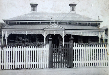
Photograph - Victorian Double-fronted Brock Villa, Cotham Road, c. 1919
... These early plans were assembled by a local firm, Jas R Mather & McMillan, which had an office in Cotham Road. ...These early plans were assembled by a local firm, Jas R Mather & McMillan, which had an office in Cotham Road. ...The Kew Historical Society's map collection includes a substantial number of real estate subdivision plans, mainly of Kew but also of surrounding suburbs in Melbourne. Most of the subdivision plans date from the 1920s and 1930s when the districts old homes and local farmland were being split up to accommodate residential growth in the postwar period. These early plans were assembled by a local firm, Jas R Mather & McMillan, which had an office in Cotham Road. Many of the plans, and sometimes photos, were annotated by the agents.Subdivision plans are historically important documents used as evidence for the growth of suburbs in Australia. They frequently provide information about when the land was sold as well as evidence relating to surveyors and real estate and financial agents. The numerous subdivision plans in the Kew Historical Society's collection represent working documents, ranging from the initial sketches made in planning a subdivision to printed plans on which auctioneers or agents listed the prices for which individual lots were sold. In a number of cases, the reverse of a subdivision plan in the collection includes a photograph of a house that was also for sale by the agent. These photographs provide significant heritage information relating house design and decoration, fencing and household gardens.The photograph may also be aesthetically significant depending o the importance of the photographic atelier.Real estate photographs of a classic double-fronted late Victorian brick villa. It central location in Cotham Road, Kew enabled the selling agent to note its proximity to the tram. With seven rooms, all ‘modern conveniences’, and land of 66×167, the house was to be sold for £1100. The villa has a number of interesting features including a pattern within the slate roof as well as the use of polychrome brickwork under the eaves and on the façade. The intricacy of the cast iron lace is emphasised by the line of projecting wooden blocks above it. The picket gate is painted a different colour to the pickets of the fence. The house has a name (illegible) that is attached to the inset cast iron lace of the central projecting gable in the veranda. Stamped on mount: "Kew. Central. Close tram. / Comfortable Brick Villa. / Containing 7 rooms / Modern conveniences: / Land 66 x 167. Sold 1100 pounds:"houses - kew, victorian villas, real estate photographs, cotham road - kew -
 Kew Historical Society Inc
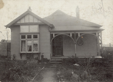
Photograph - Double-fronted Edwardian Villa, c.1918
... These early plans were assembled by a local firm, Jas R Mather & McMillan, which had an office in Cotham Road. ...These early plans were assembled by a local firm, Jas R Mather & McMillan, which had an office in Cotham Road. ...The Kew Historical Society's map collection includes a substantial number of real estate subdivision plans, mainly of Kew but also of surrounding suburbs in Melbourne. Most of the subdivision plans date from the 1920s and 1930s when the districts old homes and local farmland were being split up to accommodate residential growth in the postwar period. These early plans were assembled by a local firm, Jas R Mather & McMillan, which had an office in Cotham Road. Many of the plans, and sometimes photos, were annotated by the agents.Subdivision plans are historically important documents used as evidence for the growth of suburbs in Australia. They frequently provide information about when the land was sold as well as evidence relating to surveyors and real estate and financial agents. The numerous subdivision plans in the Kew Historical Society's collection represent working documents, ranging from the initial sketches made in planning a subdivision to printed plans on which auctioneers or agents listed the prices for which individual lots were sold. In a number of cases, the reverse of a subdivision plan in the collection includes a photograph of a house that was also for sale by the agent. These photographs provide significant heritage information relating house design and decoration, fencing and household gardens.The photograph may also be aesthetically significant depending on the importance of the photographic atelier.On the reverse of a subdivision plan of the Palmyra Estate (Kew) is a photograph of a double-fronted Edwardian villa. The weatherboard and stucco house with high brick chimneys provides a clear indication of the style of curtains and gardens in houses of the period. Holland blinds with lace inserts are used in the left front window. They are combined with long lace curtains. The garden, with its curved pathway is bordered with garden beds that include marguerite daisies and roses. Reflecting a new interest in the Australian landscape, tree ferns and ground ferns are planted closer to the house.houses - kew, architecture - edwardian, real estate photographs -
 Kew Historical Society Inc
Plan - Subdivision : Cotham and Glenferrie Roads, J R Mathers & McMillan
... These early plans were assembled by a local firm, Jas R Mather & McMillan, which had an office in Cotham Road. ...Plan Subdivision : Cotham and Glenferrie Roads J R Mathers & McMillan ...The Kew Historical Society's map collection includes a substantial number of real estate subdivision plans, mainly of Kew but also of surrounding suburbs in Melbourne. Most of the subdivision plans date from the 1920s and 1930s when the districts old homes and local farmland were being split up to accommodate residential growth in the postwar period. These early plans were assembled by a local firm, Jas R Mather & McMillan, which had an office in Cotham Road. Many of the plans, and sometimes photos, were annotated by the agents.Subdivision plans are historically important documents used as evidence for the growth of suburbs in Australia. They frequently provide information about when the land was sold as well as evidence relating to surveyors and real estate and financial agents. The numerous subdivision plans in the Kew Historical Society's collection represent working documents, ranging from the initial sketches made in planning a subdivision to printed plans on which auctioneers or agents listed the prices for which individual lots were sold. In a number of cases, the reverse of a subdivision plan in the collection includes a photograph of a house that was also for sale by the agent. These photographs provide significant heritage information relating house design and decoration, fencing and household gardens.The photograph may also be aesthetically significant depending on the importance of the photographic atelier.An undated and untitled hand-drawn and coloured subdivision plan detailing the boundaries of a number of irregular allotments bordering Cotham Road, Glenferrie Road and Stirling Avenue (now Stirling Street). The plan predates the actual subdivision that led to the creation of the eight commercial properties occupying 118-132 Cotham Road. The plan may represent an old subdivision that was further subdivided at a later date, or it may be a subdivision that never eventuated. On MMBW Detail Plan 1575 (1903), the area represented by the proposed subdivision was residential rather than commercial. The irregularity of lots is also apparent in the MMBW Plan. The largest of the unnumbered blocks on the hand-drawn subdivision plan may relate to the boundaries of the nineteenth century mansion identified as ‘Kelso’ on the MMBW Plan.subdivision plans - kew, cotham road - kew,, glenferrie road - kew , stirling avenue street - kew -
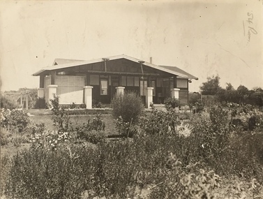
 Kew Historical Society Inc
Photograph - Cottage, probably East Kew, A. Aberline, 1920s
... These early plans were assembled by a local firm, Jas R Mather & McMillan, which had an office in Cotham Road. ...These early plans were assembled by a local firm, Jas R Mather & McMillan, which had an office in Cotham Road. ...The Kew Historical Society's map collection includes a substantial number of real estate subdivision plans, mainly of Kew but also of surrounding suburbs in Melbourne. Most of the subdivision plans date from the 1920s and 1930s when the districts old homes and local farmland were being split up to accommodate residential growth in the postwar period. These early plans were assembled by a local firm, Jas R Mather & McMillan, which had an office in Cotham Road. Many of the plans, and sometimes photos, were annotated by the agents.Subdivision plans are historically important documents used as evidence for the growth of suburbs in Australia. They frequently provide information about when the land was sold as well as evidence relating to surveyors and real estate and financial agents. The numerous subdivision plans in the Kew Historical Society's collection represent working documents, ranging from the initial sketches made in planning a subdivision to printed plans on which auctioneers or agents listed the prices for which individual lots were sold. In a number of cases, the reverse of a subdivision plan in the collection includes a photograph of a house that was also for sale by the agent. These photographs provide significant heritage information relating house design and decoration, fencing and household gardens.The photograph may also be aesthetically significant depending on the importance of the photographic atelier.An elevated, modest weatherboard house, photographed towards the end of the construction phase. The lower section of the weatherboards are exposed and stained. The upper section is rendered with rough-cast. The tiled roof has a single gable that extends over the centrally placed front porch. On the porch, the door and single sidelight are filled with coloured leadlight whereas the casement windows in the front rooms contain plain glass. The leadlight and the wrought iron of the verandah are the only decorative elements of the utilitarian design. The location of the house, which was advertised for sale, has not to date been identified. The real estate photograph is mounted on the reverse of a subdivision plan for the Harvest Home Estate, Kew East.Photographer's stamp, lower right on mount: "A. Aberline, Glenferrie"houses - kew, bungalows - kew, real estate photographs -
 Kew Historical Society Inc
Photograph - Bungalow, probably East Kew, 1920s
... These early plans were assembled by a local firm, Jas R Mather & McMillan, which had an office in Cotham Road. ...These early plans were assembled by a local firm, Jas R Mather & McMillan, which had an office in Cotham Road. ...The Kew Historical Society's map collection includes a substantial number of real estate subdivision plans, mainly of Kew but also of surrounding suburbs in Melbourne. Most of the subdivision plans date from the 1920s and 1930s when the districts old homes and local farmland were being split up to accommodate residential growth in the postwar period. These early plans were assembled by a local firm, Jas R Mather & McMillan, which had an office in Cotham Road. Many of the plans, and sometimes photos, were annotated by the agents.Subdivision plans are historically important documents used as evidence for the growth of suburbs in Australia. They frequently provide information about when the land was sold as well as evidence relating to surveyors and real estate and financial agents. The numerous subdivision plans in the Kew Historical Society's collection represent working documents, ranging from the initial sketches made in planning a subdivision to printed plans on which auctioneers or agents listed the prices for which individual lots were sold. In a number of cases, the reverse of a subdivision plan in the collection includes a photograph of a house that was also for sale by the agent. These photographs provide significant heritage information relating house design and decoration, fencing and household gardens.The photograph may also be aesthetically significant depending on the importance of the photographic atelier.An unusual bungalow that does not conform to a particular architectural style but which contains eclectic elements of the style of varying periods. The most striking element of the design is the cantilevered veranda that is supported by heavy chains that are attached to the central gable. This deep gable extends across most of the façade, forming an extensive veranda. Parts of this are infilled with screens. Seven wooden posts, whose lower halves are encased in rendered brick pillars, support this gabled veranda. The roof would appear to be covered with corrugated iron. The location of the house, which was advertised for sale, has to date not been identified. The real estate photo is on the reverse of a plan for the Myrtle Hill Subdivision, Kew.bungalows - kew, architecture - 1920s, real estate photographs -
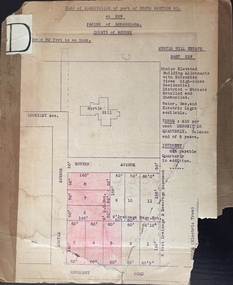 Kew Historical Society Inc
Plan - Subdivision Plan, J R Mathers & McMillan, Myrtle Hill Estate, East Kew, circa 1949, c.1949
... These early plans were assembled by a local firm, Jas R Mather & McMillan, which had an office in Cotham Road. ...These early plans were assembled by a local firm, Jas R Mather & McMillan, which had an office in Cotham Road. ...The Kew Historical Society's map collection includes a substantial number of real estate subdivision plans, mainly of Kew but also of surrounding suburbs in Melbourne. Most of the subdivision plans date from the 1920s and 1930s when the districts old homes and local farmland were being split up to accommodate residential growth in the postwar period. These early plans were assembled by a local firm, Jas R Mather & McMillan, which had an office in Cotham Road. Many of the plans, and sometimes photos, were annotated by the agents.Subdivision plans are historically important documents used as evidence for the growth of suburbs in Australia. They frequently provide information about when the land was sold as well as evidence relating to surveyors and real estate and financial agents. The numerous subdivision plans in the Kew Historical Society's collection represent working documents, ranging from the initial sketches made in planning a subdivision to printed plans on which auctioneers or agents listed the prices for which individual lots were sold. In a number of cases, the reverse of a subdivision plan in the collection includes a photograph of a house that was also for sale by the agent. These photographs provide significant heritage information relating house design and decoration, fencing and household gardens.The photograph may also be aesthetically significant depending on the importance of the photographic atelier.Myrtle Hill, at 14 Vista Avenue, Kew, is of local historical and architectural significance as a good example of a large and imposing single-storey Italianate house of the early 1870s surviving in Kew. Originally sited on a large allotment overlooking Normanby Road, the setting of the house has been dramatically altered through extensive subdivision and development. The subdivision plan of the ‘Myrtle Hill Estate’ indicates that in one such subdivision, 11 allotments were created fronting Bowyer Avenue, Myrtle Avenue, and Normanby Road. The outline and building profile of Myrtle Hill is shown on the west side of Bowyer Avenue.The full (typed) title of this subdivision plan is :"Plan of SUBDIVISION of part of CROWN PORTION 83. / at KEW / PARISH OF BOROONDARA. / COUNTY OF BOURKE". / "MYRTLE HILL ESTATE / EAST KEW" In addition to the Title and subtitle, the plan also lists the advantages of the subdivision. -
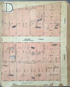 Kew Historical Society Inc
Plan, J R Mathers & McMillan, Sackville, Thomas & Lytton Streets, Kew, Twentieth Century
... These early plans were assembled by a local firm, Jas R Mather & McMillan, which had an office in Cotham Road. ...Sackville, Thomas & Lytton Streets, Kew Plan Plan J R Mathers & McMillan ...The Kew Historical Society's map collection includes a substantial number of real estate subdivision plans, mainly of Kew but also of surrounding suburbs in Melbourne. Most of the subdivision plans date from the 1920s and 1930s when the districts old homes and local farmland were being split up to accommodate residential growth in the postwar period. These early plans were assembled by a local firm, Jas R Mather & McMillan, which had an office in Cotham Road. Many of the plans, and sometimes photos, were annotated by the agents.Subdivision plans are historically important documents used as evidence for the growth of suburbs in Australia. They frequently provide information about when the land was sold as well as evidence relating to surveyors and real estate and financial agents. The numerous subdivision plans in the Kew Historical Society's collection represent working documents, ranging from the initial sketches made in planning a subdivision to printed plans on which auctioneers or agents listed the prices for which individual lots were sold. In a number of cases, the reverse of a subdivision plan in the collection includes a photograph of a house that was also for sale by the agent. These photographs provide significant heritage information relating house design and decoration, fencing and household gardens.The photograph may also be aesthetically significant depending on the importance of the photographic atelier.Lithographed subdivision plan for an un-named estate with 28 allotments facing Lytton, Sackville and Thomas Streets in Kew. The land would have originally formed part of the Dumaresq Estate. subdivision plans - kew, lytton street, sackville street, thomas street - kew -
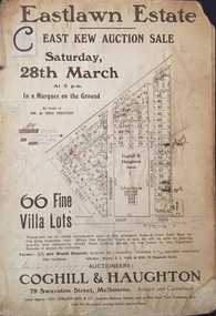 Kew Historical Society Inc
Plan - Subdivision Plan, Jas R Mathers Son & McMillan, Eastlawn Estate : East Kew Auction Sale, 1914
... These early plans were assembled by a local firm, Jas R Mather & McMillan, which had an office in Cotham Road. ...These early plans were assembled by a local firm, Jas R Mather & McMillan, which had an office in Cotham Road. ...The Kew Historical Society's map collection includes a substantial number of real estate subdivision plans, mainly of Kew but also of surrounding suburbs in Melbourne. Most of the subdivision plans date from the 1920s and 1930s when the districts old homes and local farmland were being split up to accommodate residential growth in the postwar period. These early plans were assembled by a local firm, Jas R Mather & McMillan, which had an office in Cotham Road. Many of the plans, and sometimes photos, were annotated by the agents.Subdivision plans are historically important documents used as evidence for the growth of suburbs in Australia. They frequently provide information about when the land was sold as well as evidence relating to surveyors and real estate and financial agents. The numerous subdivision plans in the Kew Historical Society's collection represent working documents, ranging from the initial sketches made in planning a subdivision to printed plans on which auctioneers or agents listed the prices for which individual lots were sold. In a number of cases, the reverse of a subdivision plan in the collection includes a photograph of a house that was also for sale by the agent. These photographs provide significant heritage information relating house design and decoration, fencing and household gardens.The photograph may also be aesthetically significant depending on the importance of the photographic atelier.The ‘Eastlawn Estate’ was surveyed and ready for auction in March 1914, three months before the outbreak of World War I. Sixty-six allotments, created on the ‘order of Mr & Miss Preston’ surrounded the mansion of Woodlands in Harp Road. Woodlands formed part of the Estate, being advertised as lot 1. The allotments faced High, Station and Wright Streets, Harp and Normanby Roads, and Woodlands Avenue. Pru Sanderson in the Kew Conservation Study (Vol.2, 1988) wrote that the Eastlawn Estate ‘covered the western half of the failed Harp of Erin Estate’. Contemporary advertisements promoted the Eastlawn Estate as: ‘There will be no more convenient district nor pleasant Suburb than East Kew for the busy business man. When the Electric Tram is laid, he will be able to journey quickly and pleasantly direct from Collins Street to his home in the Eastlawn Estate in about 20 minutes’. The actual plans of subdivision were included in advertisements in The Argus and in the local newspapers."C" top left. Various annotations.subdivision plans - kew, station street, normanby road, high street, woodlands avenue, harp road, woodlands - kew -
 Kew Historical Society Inc
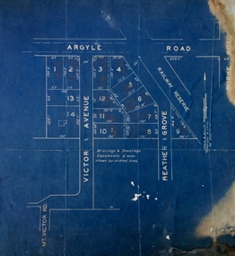
Plan - Subdivision Plan, Argyle Road, Heather Grove, Victor Avenue, Kew, c.1937
... These early plans were assembled by a local firm, Jas R Mather & McMillan, which had an office in Cotham Road. ...These early plans were assembled by a local firm, Jas R Mather & McMillan, which had an office in Cotham Road. ...The Kew Historical Society's map collection includes a substantial number of real estate subdivision plans, mainly of Kew but also of surrounding suburbs in Melbourne. Most of the subdivision plans date from the 1920s and 1930s when the districts old homes and local farmland were being split up to accommodate residential growth in the postwar period. These early plans were assembled by a local firm, Jas R Mather & McMillan, which had an office in Cotham Road. Many of the plans, and sometimes photos, were annotated by the agents.Subdivision plans are historically important documents used as evidence for the growth of suburbs in Australia. They frequently provide information about when the land was sold as well as evidence relating to surveyors and real estate and financial agents. The numerous subdivision plans in the Kew Historical Society's collection represent working documents, ranging from the initial sketches made in planning a subdivision to printed plans on which auctioneers or agents listed the prices for which individual lots were sold. In a number of cases, the reverse of a subdivision plan in the collection includes a photograph of a house that was also for sale by the agent. These photographs provide significant heritage information relating house design and decoration, fencing and household gardens.The photograph may also be aesthetically significant depending on the importance of the photographic atelier.Undated blue subdivision plan in Kew of 14 lots facing Argyle Road, Heather Grove and Victor Road. The Plan identifies Tuxen & Miller as the surveyors. [Formerly catalogued as MAP.0059]subdivision plans - kew, argyle road - kew, heather grove - kew, victor avenue - kew -
 Kew Historical Society Inc
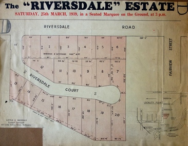
Plan - Subdivision Plan, Riversdale Estate, 1939
... It is believed that the majority of the plans were gifted to the Society by persons connected with the real estate firm - J. R. Mathers and McMillan, 136 Cotham Road, Kew. ...Riversdale Estate Plan Subdivision Plan J R Mathers & McMillan ...The Kew Historical Society collection includes almost 100 subdivision plans pertaining to suburbs of the City of Melbourne. Most of these are of Kew, Kew East or Studley Park, although a smaller number are plans of Camberwell, Deepdene, Balwyn and Hawthorn. It is believed that the majority of the plans were gifted to the Society by persons connected with the real estate firm - J. R. Mathers and McMillan, 136 Cotham Road, Kew. The Plans in the collection are rarely in pristine form, being working plans on which the agent would write notes and record lots sold and the prices of these. The subdivision plans are historically significant examples of the growth of urban Melbourne from the beginning of the 20th Century up until the 1980s. A number of the plans are double-sided and often include a photograph on the reverse. A number of the latter are by noted photographers such as J.E. Barnes.The Riversdale Estate in Hawthorn created a subdivision of 20 allotments bordering on Riversdale Road and Riversdale Court (which was created by the subdivision). The Locality Plan at right lists the major public buildings in the area: Burnely Horticultural Gardens, Hawthorn Tram Depot and Railway Station, Scotch College and the River Yarra and The Boulevard.subdivision plans - hawthorn, riversdale estate -
 Kew Historical Society Inc
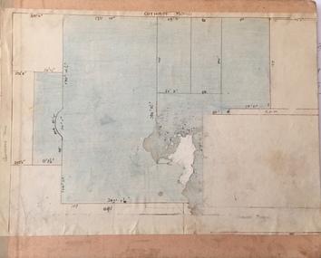
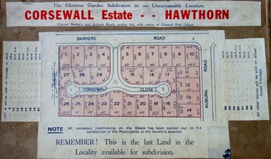
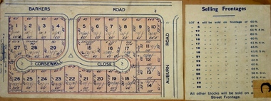
Plan - Subdivision Plan, Corsewall Estate, Hawthorn, 1938
... It is believed that the majority of the plans were gifted to the Society by persons connected with the real estate firm - J. R. Mathers and McMillan, 136 Cotham Road, Kew. ...Corsewall Estate, Hawthorn Plan Subdivision Plan J R Mathers & McMillan ...The Kew Historical Society collection includes almost 100 subdivision plans pertaining to suburbs of the City of Melbourne. Most of these are of Kew, Kew East or Studley Park, although a smaller number are plans of Camberwell, Deepdene, Balwyn and Hawthorn. It is believed that the majority of the plans were gifted to the Society by persons connected with the real estate firm - J. R. Mathers and McMillan, 136 Cotham Road, Kew. The Plans in the collection are rarely in pristine form, being working plans on which the agent would write notes and record lots sold and the prices of these. The subdivision plans are historically significant examples of the growth of urban Melbourne from the beginning of the 20th Century up until the 1980s. A number of the plans are double-sided and often include a photograph on the reverse. A number of the latter are by noted photographers such as J.E. Barnes.This is a second, more complete version of the Corsewall Estate subdivision that is held by the Society. The Coreswall Estate was a subdivision, bordering on Barkers Road and Auburn Road, which created Corsewall Close. This relatively late subdivision included 29 allotments. The subdivision plan includes the dimensions of each lot as well as the width of the existing and projected roads and turning circles. The Corsewall Close Precinct is now listed on the Victorian Heritage Database (HO147) and is noted for its ‘consistent flat-type development over the entire street, which has been cleverly designed to make multi-unit dwellings appear as single buildings’. In this second version of the plan, the rarity of this late subdivision is emphasised by the auctioneers. The original plan must have contained a photograph, which is unfortunately truncated here.subdivision plans - hawthorn, corsewall estate -
 Kew Historical Society Inc
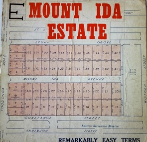
Plan - Subdivision Plan, Mount Ida Estate, 1925
... It is believed that the majority of the plans were gifted to the Society by persons connected with the real estate firm - J. R. Mathers and McMillan, 136 Cotham Road, Kew. ...Mount Ida Estate Plan Subdivision Plan J R Mathers & McMillan ...The Kew Historical Society collection includes almost 100 subdivision plans pertaining to suburbs of the City of Melbourne. Most of these are of Kew, Kew East or Studley Park, although a smaller number are plans of Camberwell, Deepdene, Balwyn and Hawthorn. It is believed that the majority of the plans were gifted to the Society by persons connected with the real estate firm - J. R. Mathers and McMillan, 136 Cotham Road, Kew. The Plans in the collection are rarely in pristine form, being working plans on which the agent would write notes and record lots sold and the prices of these. The subdivision plans are historically significant examples of the growth of urban Melbourne from the beginning of the 20th Century up until the 1980s. A number of the plans are double-sided and often include a photograph on the reverse. A number of the latter are by noted photographers such as J.E. Barnes.The Mount Ida Estate was a subdivision of fifty-two residential allotments bordering Tooronga Road, Leura Grove, Constance Street, and Mount Ida Avenue in Hawthorn East. The report of the sale of the Estate in The Argus (21 September) claimed that over 1,000 people attended the auction and that all allotments were sold on the day. On the other side of Constance Street, the plan identifies the ‘Eastern Recreation Reserve’ (now Anderson Park).subdivision plans - hawthorn -
 Kew Historical Society Inc
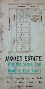
Plan - Subdivision Plan, Jaques Estate, 1927
... It is believed that the majority of the plans were gifted to the Society by persons connected with the real estate firm - J. R. Mathers and McMillan, 136 Cotham Road, Kew. ...Jaques Estate Plan Subdivision Plan J R Mathers & McMillan ...The Kew Historical Society collection includes almost 100 subdivision plans pertaining to suburbs of the City of Melbourne. Most of these are of Kew, Kew East or Studley Park, although a smaller number are plans of Camberwell, Deepdene, Balwyn and Hawthorn. It is believed that the majority of the plans were gifted to the Society by persons connected with the real estate firm - J. R. Mathers and McMillan, 136 Cotham Road, Kew. The Plans in the collection are rarely in pristine form, being working plans on which the agent would write notes and record lots sold and the prices of these. The subdivision plans are historically significant examples of the growth of urban Melbourne from the beginning of the 20th Century up until the 1980s. A number of the plans are double-sided and often include a photograph on the reverse. A number of the latter are by noted photographers such as J.E. Barnes.The Jaques Estate was a small subdivision of eight residential allotments bordering Jaques Street and Barkers Road in what is now Hawthorn East. Advertised in The Argus as being in ‘Upper Hawthorn’ the subdivision was claimed to include: ‘charming villa sites in excellent situations, with every convenience available, and with superior homes surrounding’.subdivision plans - hawthorn, jaques estate -
 Kew Historical Society Inc
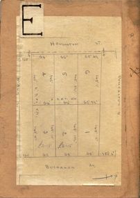
Plan - Subdivision Plan, Houghton Street & Buchanan Avenue, Balwyn North, ca. 1906
... It is believed that the majority of the plans were gifted to the Society by persons connected with the real estate firm - J. R. Mathers and McMillan, 136 Cotham Road, Kew. ...Houghton Street & Buchanan Avenue, Balwyn North Plan Subdivision Plan J R Mathers & McMillan ...The Kew Historical Society collection includes almost 100 subdivision plans pertaining to suburbs of the City of Melbourne. Most of these are of Kew, Kew East or Studley Park, although a smaller number are plans of Camberwell, Deepdene, Balwyn and Hawthorn. It is believed that the majority of the plans were gifted to the Society by persons connected with the real estate firm - J. R. Mathers and McMillan, 136 Cotham Road, Kew. The Plans in the collection are rarely in pristine form, being working plans on which the agent would write notes and record lots sold and the prices of these. The subdivision plans are historically significant examples of the growth of urban Melbourne from the beginning of the 20th Century up until the 1980s. A number of the plans are double-sided and often include a photograph on the reverse. A number of the latter are by noted photographers such as J.E. Barnes.A hand-drawn subdivision plan listing six blocks bounded by Houghton Street, Doncaster Road, Buchanan Avenue and Maud Street, North Balwyn. Written on the plan of subdivision are the lot numbers, the dimensions of the blocks and the price at which two lots were for sale or had been sold for.subdivision plans - balwyn -
 Kew Historical Society Inc
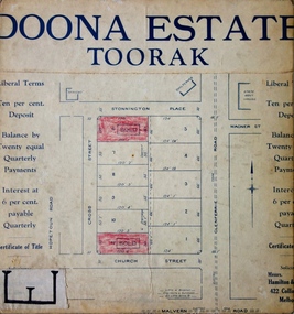
Plan - Subdivision Plan, Doona Estate, Toorak, 1929
... It is believed that the majority of the plans were gifted to the Society by persons connected with the real estate firm - J. R. Mathers and McMillan, 136 Cotham Road, Kew. ...Doona Estate, Toorak Plan Subdivision Plan J R Mathers & McMillan ...The Kew Historical Society collection includes almost 100 subdivision plans pertaining to suburbs of the City of Melbourne. Most of these are of Kew, Kew East or Studley Park, although a smaller number are plans of Camberwell, Deepdene, Balwyn and Hawthorn. It is believed that the majority of the plans were gifted to the Society by persons connected with the real estate firm - J. R. Mathers and McMillan, 136 Cotham Road, Kew. The Plans in the collection are rarely in pristine form, being working plans on which the agent would write notes and record lots sold and the prices of these. The subdivision plans are historically significant examples of the growth of urban Melbourne from the beginning of the 20th Century up until the 1980s. A number of the plans are double-sided and often include a photograph on the reverse. A number of the latter are by noted photographers such as J.E. Barnes.The Doona Estate subdivision of 1929 created 11 new allotments bordered by Glenferrie Road, Stonnington Place, Cross and Church Streets. On the right of the plan, the location of ‘State Govt. House’ is noted. Stonnington was to be maintained as Victoria’s Government House until 1931, two years after the Doona Estate subdivision was released.subdivision plans - toorak, doona estate -
 Kew Historical Society Inc
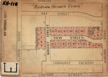
Plan - Subdivision Plan, Auburn Heights Estate, 1921
... It is believed that the majority of the plans were gifted to the Society by persons connected with the real estate firm - J. R. Mathers and McMillan, 136 Cotham Road, Kew. ...Auburn Heights Estate Plan Subdivision Plan J R Mathers & McMillan ...The Kew Historical Society collection includes almost 100 subdivision plans pertaining to suburbs of the City of Melbourne. Most of these are of Kew, Kew East or Studley Park, although a smaller number are plans of Camberwell, Deepdene, Balwyn and Hawthorn. It is believed that the majority of the plans were gifted to the Society by persons connected with the real estate firm - J. R. Mathers and McMillan, 136 Cotham Road, Kew. The Plans in the collection are rarely in pristine form, being working plans on which the agent would write notes and record lots sold and the prices of these. The subdivision plans are historically significant examples of the growth of urban Melbourne from the beginning of the 20th Century up until the 1980s. A number of the plans are double-sided and often include a photograph on the reverse. A number of the latter are by noted photographers such as J.E. Barnes.The name ‘Auburn Heights Estate’, was handwritten on the subdivision plan, and included 23 lots in Auburn Road and Wright and View Streets, Hawthorn. Most of the houses built on the lots that were sold still exist. The house built on number 8 View Street is a contemporary exception. The subdivision included an existing home at number 17 View Street.subdivision plans - hawthorn, auburn heights estate -
 Kew Historical Society Inc
Plan - Subdivision Plan, Corsewall Estate, 1938
... It is believed that the majority of the plans were gifted to the Society by persons connected with the real estate firm - J. R. Mathers and McMillan, 136 Cotham Road, Kew. ...Corsewall Estate Plan Subdivision Plan J R Mathers & McMillan ...The Kew Historical Society collection includes almost 100 subdivision plans pertaining to suburbs of the City of Melbourne. Most of these are of Kew, Kew East or Studley Park, although a smaller number are plans of Camberwell, Deepdene, Balwyn and Hawthorn. It is believed that the majority of the plans were gifted to the Society by persons connected with the real estate firm - J. R. Mathers and McMillan, 136 Cotham Road, Kew. The Plans in the collection are rarely in pristine form, being working plans on which the agent would write notes and record lots sold and the prices of these. The subdivision plans are historically significant examples of the growth of urban Melbourne from the beginning of the 20th Century up until the 1980s. A number of the plans are double-sided and often include a photograph on the reverse. A number of the latter are by noted photographers such as J.E. Barnes.The Corsewall Estate was a subdivision, bordering on Barkers Road and Auburn Road, which created Corsewall Close. This relatively late subdivision included 29 allotments. The subdivision plan includes the dimensions of each lot as well as the width of the existing and projected roads and turning circles. The Corsewall Close Precinct is now listed on the Victorian Heritage Database (HO147) and is noted for its ‘consistent flat-type development over the entire street, which has been cleverly designed to make multi-unit dwellings appear as single buildings’.subdivision plans - hawthorn, corsewall estate -- hawthorn (vic.) -
 Kew Historical Society Inc
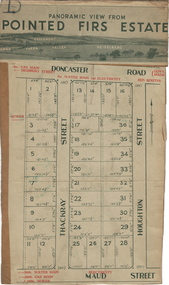
Plan - Subdivision Plan, Pointed Firs Estate, 1936
... It is believed that the majority of the plans were gifted to the Society by persons connected with the real estate firm - J. R. Mathers and McMillan, 136 Cotham Road, Kew. ...Pointed Firs Estate Plan Subdivision Plan J R Mathers & McMillan ...The Kew Historical Society collection includes almost 100 subdivision plans pertaining to suburbs of the City of Melbourne. Most of these are of Kew, Kew East or Studley Park, although a smaller number are plans of Camberwell, Deepdene, Balwyn and Hawthorn. It is believed that the majority of the plans were gifted to the Society by persons connected with the real estate firm - J. R. Mathers and McMillan, 136 Cotham Road, Kew. The Plans in the collection are rarely in pristine form, being working plans on which the agent would write notes and record lots sold and the prices of these. The subdivision plans are historically significant examples of the growth of urban Melbourne from the beginning of the 20th Century up until the 1980s. A number of the plans are double-sided and often include a photograph on the reverse. A number of the latter are by noted photographers such as J.E. Barnes.An almost identical plan of the ‘Pointed Firs Estate’ is in the State Library of Victoria. The plan unusually uses a photograph to show the panoramic views from the Estate. A prospective purchaser could expect to look across the Yarra Valley to Eaglemont and Heidelberg. The 36 lots advertised for sale faced Doncaster Road, Houghton Street, Maud Street and Thackray Street in Balwyn North.subdivision plans - balwyn, pointed firs estate -
 Kew Historical Society Inc
Plan - Subdivision Plan, Lodged Plan No.6518, 1920-1940
... It is believed that the majority of the plans were gifted to the Society by persons connected with the real estate firm - J. R. Mathers and McMillan, 136 Cotham Road, Kew. ...Lodged Plan No.6518 Plan Subdivision Plan Jas R Mathers Son & McMillan ...The Kew Historical Society collection includes almost 100 subdivision plans pertaining to suburbs of the City of Melbourne. Most of these are of Kew, Kew East or Studley Park, although a smaller number are plans of Camberwell, Deepdene, Balwyn and Hawthorn. It is believed that the majority of the plans were gifted to the Society by persons connected with the real estate firm - J. R. Mathers and McMillan, 136 Cotham Road, Kew. The Plans in the collection are rarely in pristine form, being working plans on which the agent would write notes and record lots sold and the prices of these. The subdivision plans are historically significant examples of the growth of urban Melbourne from the beginning of the 20th Century up until the 1980s. A number of the plans are double-sided and often include a photograph on the reverse. Reconciling this hand-drawn subdivision plan with a modern map of the area is initially a challenge due to a change of street names. Argyle Road in the centre of the subdivision was to be renamed Deepdene Road, and the street named Deepdene Road on the plan was to become Deepdene Place. Of interest is the nursery on the corner of Argyle and Whitehorse Roads. During this period there were a number of nurseries servicing the Kew and Balwyn areas. The subdivision was essentially of the land formerly occupied by the house 'Deepdene'.subdivision plans - balwyn, deepdene, whitehorse road -- deepdene (vic.), deepdene road -- deepdene (vic.), burke road -- deepdene (vic.) -
 Kew Historical Society Inc
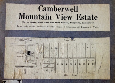
Plan - Subdivision Plan, Camberwell Mountain View Estate, 1923
... It is believed that the majority of the plans were gifted to the Society by persons connected with the real estate firm - J. R. Mathers and McMillan, 136 Cotham Road, Kew. ...Camberwell Mountain View Estate Plan Subdivision Plan J R Mathers & McMillan ...The Kew Historical Society collection includes almost 100 subdivision plans pertaining to suburbs of the City of Melbourne. Most of these are of Kew, Kew East or Studley Park, although a smaller number are plans of Camberwell, Deepdene, Balwyn and Hawthorn. It is believed that the majority of the plans were gifted to the Society by persons connected with the real estate firm - J. R. Mathers and McMillan, 136 Cotham Road, Kew. The Plans in the collection are rarely in pristine form, being working plans on which the agent would write notes and record lots sold and the prices of these. The subdivision plans are historically significant examples of the growth of urban Melbourne from the beginning of the 20th Century up until the 1980s. A number of the plans are double-sided and often include a photograph on the reverse. A number of the latter are by noted photographers such as J.E. Barnes.The so-called Camberwell Mountain View Estate was a subdivision on ‘the corner [of] Burke Road, Eyre and Wills Streets, Deepdene’. The Estate was not the first attempt to subdivide this land holding. In 1884, 1888 and 1894 the Belmore Park subdivision proposed 18 allotments for this parcel of land. The final stages of the Belmore Park subdivision occurred during the Depression of the 1890s. Apart from perhaps one block facing Burke Road, which is unnumbered in the Mountain View Estate subdivision, the rest must have remained unsold. The later subdivision would redraw the original 18 allotments, creating 22 new lots. In the Locality Plan on the left side of the subdivision plan, Deepdene Station, which formed part of the Outer Circle Railway is represented, as is the location of Deepdene Primary School. A selling point was the proposed extension of the Burke Road tram beyond its terminus at Cotham Road. The extension did not eventuate.subdivision plans - camberwell, mountain view estate