Showing 49 items matching " no 7 reservoir"
-
 Bendigo Historical Society Inc.
Document - BENDIGO'S WATER SUPPLY
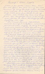
... ... No 7 Reservoir...History House 11 Mackenzie Street Bendigo goldfields DOCUMENT Bendigo's Water Supply E H Emmett Bendigo Water Works Co No 7 Reservoir Law Courts Coliban Scheme J F Sullivan The Bendigo Council Water Works Robinson Crusoe Gully Angus Mackay State Rivers and Water Supply Commission Lauriston Reservoir Lake Eppalock Dates when Reservoirs were built Preston Vale Bendigo and Vicinity Handwritten notes titled 'Bendigo's Water Supply'. ...Handwritten notes titled 'Bendigo's Water Supply'. Notes mention the early water supply for Bendigo, The construction of the reservoirs, some costs, and the dates they were constructed.document, bendigo's water supply, e h emmett, bendigo water works co, no 7 reservoir, law courts, coliban scheme, j f sullivan, the bendigo council, water works, robinson crusoe gully, angus mackay, state rivers and water supply commission, lauriston reservoir, lake eppalock, dates when reservoirs were built, preston vale, bendigo and vicinity -
 Clunes Museum
Photograph - PHOTOGRAPH & COPIES, PUBLISHED BY E. BARNETT
... THE METHODIST CHURCH CLUNES VIC .3NEWLYN RESERVOIR 7/10/1909...THE METHODIST CHURCH CLUNES VIC .3NEWLYN RESERVOIR 7/10/1909 Photograph PHOTOGRAPH & COPIES PUBLISHED BY E. ....1 COPY OF PHOTOGRAPH OF BAILEY ST, CLUNES WITH POST OFFICE AND TOWNHALL, HORSE AND CART IN FRONT .2 COPY OF PHOTOGRAPH. THE METHODIST CHURCH CLUNES VIC .3NEWLYN RESERVOIR 7/10/1909bailey street clunes, methodist church, newlyn reservoir -
 Wodonga & District Historical Society Inc
Album - Hume Reservoir Australia Album - Quarry plant being erected September 1921
... RIVER MURRAY WATERS SCHEME. HUME RESERVOIR. 7. Quarry plant (New South Wales) being erected, September 1921. ...RIVER MURRAY WATERS SCHEME. HUME RESERVOIR. 7. Quarry plant (New South Wales) being erected, September 1921. ...This set of photos is from a leather bound album bearing the inscription "HUME RESERVOIR AUSTRALIA" plus 'The Rt. Hon. L. C. M. S. Amery, P. C., M .P.' all inscribed in gold. It was presented to The Rt. Hon. L. C. M. S. Amery, P. C., M. P, Secretary of State for Dominion Affairs on the occasion of his visit to the Hume Reservoir on 2nd November 1927. This album is of local and national significance as it documents the planning and development of the Hume Reservoir up to 1927. It was the largest water reservoir in the British Empire. The album records the pioneering engineering work that went into its construction.DEPARTMENT OF PUBLIC WORKS, N.S.W. RIVER MURRAY WATERS SCHEME. HUME RESERVOIR. 7. Quarry plant (New South Wales) being erected, September 1921. Murray Flats (in foreground) and Mitta Mitta Flats (beyond) flooded.hume reservoir australia, river murray waters scheme, quarry plant hume -
 Bendigo Historical Society Inc.
Photograph - HILDA HILL COLLECTION: BLACK AND WHITE PHOTOS
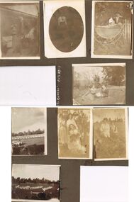
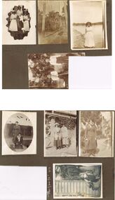
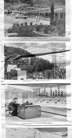
... Group of people, all but one females, all in white at No. 7 reservoir happy 9 January 1919. Al and Marie sitting, Al in all white and hatless, Marie in white blouse and black waistcoat with black tie, foreground shows large rocks, background has trees in distance, No.7 reservoir 9 January 1919. ...Group of people, all but one females, all in white at No. 7 reservoir happy 9 January 1919. Al and Marie sitting, Al in all white and hatless, Marie in white blouse and black waistcoat with black tie, foreground shows large rocks, background has trees in distance, No.7 reservoir 9 January 1919. ...Hilda Hill Collection. Combination Sepia & Black & White Photos Double Sided Card Total of 8 depicting family life towards the end of the First World War in 1918 up until July 1924. A comparison exists between life at 'The Ranch' ? In Eppalock in 1918 versus life at 'The Ranch' in 1924. lady standing at the front of the house with left arm raised to shade her eyes dressed in a dark coloured dress, light coloured cover on chair in background at 'the Ranch' June 1918. Oval black and white photo of Doreen at Durvol, dressed in black skirt and white shirt with black school? Tie June 1918. Proud parents with baby sitting in pram, both p[parents are wearing dark coloured hats dark clothing and white shirts, pram is boat style body with large rear wheels and smaller front wheels. White picket fence in background, May 1918. Also on this page is a reference to 'The Ranch' July 1924 in white, but no photo. Claire and Doreen sitting on lawn area, small garden to left, row of decorative plants in semi circle, dead tree centre background and other trees to left and right background, S.H.L.C. 24 Sept 1918. Boys' Flag Drill - repatriation Upper Reserve 19 October 1918. Group of people, all but one females, all in white at No. 7 reservoir happy 9 January 1919. Al and Marie sitting, Al in all white and hatless, Marie in white blouse and black waistcoat with black tie, foreground shows large rocks, background has trees in distance, No.7 reservoir 9 January 1919. Childrens folk dance at Upper Reserve, All children dressed in white, large round hat in foreground, and suited man in hat walking past 19 October 10918.Hilda Hill Personal Collectionaustralia, history, post war life -
 Bendigo Historical Society Inc.
Photograph - HILDA HILL COLLECTION: BLACK AND WHITE PHOTOS, 1918-1920
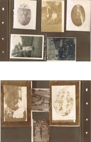
... Group of seven girls and 4 boys, all of the girls are dressed in white, front girl has black neck accessory, 'The Pines' January 9 1919 No. 7 Reservoir....Group of seven girls and 4 boys, all of the girls are dressed in white, front girl has black neck accessory, 'The Pines' January 9 1919 No. 7 Reservoir. Photograph HILDA HILL COLLECTION: BLACK AND WHITE PHOTOS ...Hilda Hill Collection. Black & White Photos of Hill Family Total 9. Three girls at SHLC 1918 with white sashes and medallions, dark clothing with white collars, background is garden scene , photo has over exposure problem which gives a lighter print, 24 September 1918, could it be a ladies college of education? Al standing wearing white blouse and dark dress holding a white hat standing and Gert sitting and holding a white hat in front of a bush wearing a white blouse and a light coloured skirt, background is forested area, 'The Pines' January 9th 1919. Claire dressed in dark dress and wearing a white hat with her hands together, oval photo, 'The Ranche', October 23 1918. Jonah wearing a hat and white dress with colourful hemline standing before a large hedge holding a parasol, large tree background left, 'The Ranche'. Three boys and two dogs All boys dressed in dark coats and shorts long socks two of the boys are on their haunches, Background is a gabled roof and 2 chimneys, white fence, between two of the boys is a water tap on a medium height pipe, Durvol December 1919. Moll Noonan seated on a round backed chair wearing a white dress, right background shows the side of a building, at knee level sis a broad leafed plant, other shrubbery in the background, 'The Ranche' November 1918. Ettie seated on a staircase and holding a dog, lady is wearing a broad brimmed hat, One Tree Hill April 18 1920. Two ladies in lightly coloured dresses standing in a garden setting, lady on left has a black sash waistband, Durvol December 1919 . Group of seven girls and 4 boys, all of the girls are dressed in white, front girl has black neck accessory, 'The Pines' January 9 1919 No. 7 Reservoir.Hilda Hill Personal Collectionaustralia, history, post war life -
 Bendigo Historical Society Inc.
Photograph - HILDA HILL COLLECTION: BLACK AND WHITE PHOTOS, 1918-1919
... Smith Lady standing on shore at Reservoir No. 7 Kangaroo Flat 09/011919. two boys standing in bush scene wearing white shirts and dark trouser held up with braces, boy on left holding long stick with both hands. ...Smith Lady standing on shore at Reservoir No. 7 Kangaroo Flat 09/011919. two boys standing in bush scene wearing white shirts and dark trouser held up with braces, boy on left holding long stick with both hands. ...7 Complete Black & White Photographs: Maisie and Bess One standing wearing a light coloured dress and one kneeling wearing Dark suit with white blouse on pathway, background is large hedge, right background is a corner of a lawn area, oval photo, S.H.L.C. 24 September 1918. House in Bendigo With Pillared Gate & Picket Fence, Tess & Dorothy Out The Front 21/10/1918. Claire wearing a dark coloured coat dress standing in a garden setting, light post to her left, hose laying on the path to her left, small flat roofed shed near light post 'The Ranche' 23/10/1918. Nancy wearing a tunic style dress and white blouse standing next to a wall with a pot plant at front, 'The Ranche' 1919. Group Photo Three Ladies wearing all white outfits and two with white hats, two standing one sitting, at front is small case and Thermos flask, grubby but happy the end of a perfect day Axedale Hibernian Picnic 13/11/1918. Two Ladies wearing heavy coats on rope swing Botanical gardens Bendigo June Year Unknown Cation On photo Illegible, Mo. Smith Lady standing on shore at Reservoir No. 7 Kangaroo Flat 09/011919. two boys standing in bush scene wearing white shirts and dark trouser held up with braces, boy on left holding long stick with both hands. Part of this photo has been cut off in the process of taking a photo from the other side.Hilda Hill Personal Collectionaustralia, history, post war life -
 Warrnambool and District Historical Society Inc.
Administrative record - Warrnambool Water Trust Notebook, late 19th century (1892-1900)
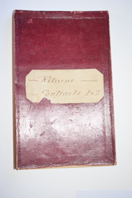
... The first contract, with the contractors, Coates and Reed, is for the excavation for settling tanks and clear water basin and a reservoir in Liebig Street and there are 60 pages giving details of these works - labour, masonry, concreting, fencing etc. The second contract with the contractor, William Kellas, is for the erection of a cottage and an engine shed and boiler room (7 pages). ...The first contract, with the contractors, Coates and Reed, is for the excavation for settling tanks and clear water basin and a reservoir in Liebig Street and there are 60 pages giving details of these works - labour, masonry, concreting, fencing etc. The second contract with the contractor, William Kellas, is for the erection of a cottage and an engine shed and boiler room (7 pages). ...This notebook appears to be the Warrnambool Water Trust Records of two contracts in 1892 . (The reference is written as 'W.W.Trust'.) The first contract, with the contractors, Coates and Reed, is for the excavation for settling tanks and clear water basin and a reservoir in Liebig Street and there are 60 pages giving details of these works - labour, masonry, concreting, fencing etc. The second contract with the contractor, William Kellas, is for the erection of a cottage and an engine shed and boiler room (7 pages). The Warrnambool Water Trust was set up in 1891 and the first project was the supply of water from the Merri River near Wollaston to a reservoir and tower in Liebig Street and this notebook concerns some details of this early water supply scheme. This notebook is of some interest as it supplies details of a late 19th century Warrnambool water supply scheme and so should be of value to local history researchers This is a notebook with a red leather cover and pages with printed headings and ruled red lines. The pages contain handwriting in black ink. The cover has a label (partly torn) with handwriting.Returns Contracts 1 & 2warrnambool water supply, warrnambool water board, 19th century water in warrnambool -
 Kiewa Valley Historical Society
Photograph - Bogong Village (7 copies), Approx 1940
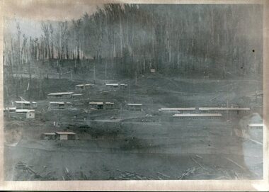
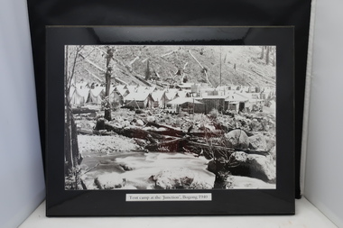
... reservoirs used to supply the power stations their main power to run the huge turbines generating the final product, electricity. Evidence can be seen of the 1939 bushfires. Bogong Village SECV Handwritten on the back of one photo - Bogong Village approx. 1940, after 1939 bush fires. Staff residences to left. Kiewa House, General offices and test lab to the right. Hand drawn map on the back of one photo. Set of 7 ...In 1940 Field Headquarters for the Kiewa Scheme were established at Bogong with office, workshop facilities and accommodation for workmen, staff and some families constructed. (There had been a 'tent camp' on this site in 1939 but was destroyed by bushfires) Construction of accommodation continued until 1947. A total of 40 houses plus a hostel for single staff, post office, police station, medical centre and primary school all with water and sewerage and electricity supply. The staff hostel was known as Kiewa House and is now occupied by the Education Department. Lake Guy was named after Mr. L.T. Guy who was the Resident Engineer in charge of construction work and associated activities on the Kiewa area. He held this position from 1939 to November 1946 when he was transferred to Head Office. The Bogong Township was developed firstly as an accommodation centre (base camp) for construction workers employed under the Kiewa Hydroelectric Scheme. Due to the influx of European workers into the Township the beautification of the immediate surrounds (gardens etc.) had a distinct European flavour. This environment has been very beneficial for tourism in later years. At the completion of the scheme, in the 1960's, the village was opened to public/tourism use. Strict environmental control has not allowed for any extensive redevelopment in tourist accommodation and basically restricted it to the accommodation initially built for the construction workers. Activities such a bike riding, snow skiing, restricted horse riding and bush walking on the Alpine plains and mountains are now a viable part of the Kiewa Valley Tourist Industry. The lake is one of the many water storage reservoirs used to supply the power stations their main power to run the huge turbines generating the final product, electricity. Evidence can be seen of the 1939 bushfires.Set of 7 identical black and white photographs of Bogong Village after 1939 bush firesHandwritten on the back of one photo - Bogong Village approx. 1940, after 1939 bush fires. Staff residences to left. Kiewa House, General offices and test lab to the right. Hand drawn map on the back of one photo.bogong village, secv -
 Kiewa Valley Historical Society
4 Photos framed - Kiewa Hydro Electric Scheme 1940s
... Bogong township 1940 Junction Dam 1944 Reservoir Camp 1940 Bogong Stables 1940 Tent camp at Bogong Sticker on the back of each photo: 'Framing/ Colour Magic / Shop 7, Lismore Central / Carrington Street, Lismore / Phone (02) 6621 3289' 1. ...These 4 black and white photos are very clear and are of Bogong in the 1940s when the Kiewa Hydro electric Scheme was being constructed. Bogong was the first construction site. Bogong was a township and construction site for the Kiewa Hydro Electric Scheme built by the State Electricity Commission of Victoria. These photos in the early 1940s (during WW2) tell the story of fire, flood and living conditions with the inference of transport being horses in 1940 compared with its development in 1944.1. Tent camp at the 'Junction', Bogong 1940 2. Junction Dam September 1940: floodwaters over coffer dam 3. 'Reservoir' Camp with Bogong Stables in foreground, 1940 4. Junction Dam and Bogong village in August 1944 Each photo has string attached on the back with tape - for hangingSticker on the back of each photo: 'Framing/ Colour Magic / Shop 7, Lismore Central / Carrington Street, Lismore / Phone (02) 6621 3289'bogong township 1940, junction dam 1944, reservoir camp 1940, bogong stables 1940, tent camp at bogong -
 Kiewa Valley Historical Society
Postcard - Mt Beauty and the Kiewa Hydro Electric Scheme
... Reservoir, Kiewa 3. No. 3 Power Station, Kiewa 4. Generators, No. 3 Power Station 5. Turbines, No. 4 Power Station, Kiewa 6. junction Dam, Bogong 7. ...Reservoir, Kiewa 3. No. 3 Power Station, Kiewa 4. Generators, No. 3 Power Station 5. Turbines, No. 4 Power Station, Kiewa 6. junction Dam, Bogong 7. ...SECV constructed the Kiewa Hydro Electric Scheme including the township of Mt Beauty. The area became a popular tourist destination.Tourism in the Kiewa Valley especially at Mt Beauty and the Bogong High Plains along with the Kiewa Hydro Electric Scheme became very popular and an important industry.Fold out b & w postcard with 12 photos back to back. All with a title. Kate 1950s 1. High Voltage Transmission Line, showing Mount Beauty Township 2. Clover Dam Reservoir, Kiewa 3. No. 3 Power Station, Kiewa 4. Generators, No. 3 Power Station 5. Turbines, No. 4 Power Station, Kiewa 6. junction Dam, Bogong 7. Mt Beauty Village Shopping Centre 8. Switchyard, No. 4 Power Station, Kiewa 9. Control Room, No. 4 Power Station, Kiewa 10. Winter Scene at Rocky Valley on the Bogong High Plains 11. Water Channel, Mt Bogong in Background 12. Mt Beauty Township, Kiewa Valleytransmission line, power station, generators, mt beauty, turbines, junction dam, switchyard, rocky valley, control room -
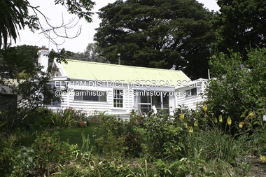 Eltham District Historical Society Inc
Photograph - Digital Photograph, Alan King, Garden Hill, Eltham-Yarra Glen Road, Kangaroo Ground, 3 February 2008
... reservoir, the family sold all, except the minimum 20 acres allowed, to the Board in the 1970s. Orwell then leased what was the family property from the Board to continue grazing. The two sisters and brother continued to live on the property. This collection of almost 130 photos about places and people within the Shire of Nillumbik, an urban and rural municipality in Melbourne's north, contributes to an understanding of the history of the Shire. Published in 2008 immediately prior to the Black Saturday bushfires of February 7 ...The original house was built around 1850 was one of Kangaroo Ground's earliest homes, part of which remains today. Built by Scottish farmer Andrew Harkness who acquired the property in 1849 at the top of the hill with magnificent panoramic views as far as Kinglake, the same year he married Sarah Oswin. The property was known as Garden Hill from at least 1865. Andrew and Sarah had four sons and five daughters. Harkness was a founder of the Kangaroo Ground School and one of the first to suggest establishing the Eltham District Road Board (1858-71) of which he was a member, the pre-cursor to the Shire of Eltham (1871-1994). He was also a Trustee of the Kangaroo Ground Cemetery. His daughter Fanny married farmer Alexander White who purchased the property in 1893. Alexander White died in 1906 and ownership transferred to Fanny White. Son, Robert White was a Councillor of the Shire of Eltham at the time the Shire acquired two acres of land on the adjacent property from the Mess brothers for the creation of the Shire of Eltham Memorial Park (1921) in which the Shire of Eltham War Memoirial tower was erected (1926). Fanny White donated a small section of land from the Garden Hill property to facilitate entry access to the park. The White family sold the property to Sir Herbert Gepp in 1925. Covered under Heritage Overlay, Nillumbik Planning Scheme. Published: Nillumbik Now and Then / Marguerite Marshall 2008; photographs Alan King with Marguerite Marshall.; p29 Garden Hill, on Yarra Glen Road, Kangaroo Ground, near the War Memorial is well named. The old house and gardens overlook a magnificent panorama extending to Kinglake. The original house, built around 1850, was one of Kangaroo Ground’s earliest, and part of it remains in today’s timber house. The house was built by the early and prominent settler Andrew Harkness. Later it was occupied for a long time by Sir Herbert Gepp, renowned Australia wide.1 Harkness and Gepp are buried in the Kangaroo Ground Cemetery. Scottish farmer Harkness, who was born in 1817, acquired this property in 18492 and he and his family occupied it until the early 1920s. Harkness cleared its 152 acres (61.4 ha), fenced it and grazed sheep and cattle. Harkness proved a valuable community member. When only ten families lived in the district, he and other settlers set up a school in 1852, with Andrew Ross as the first teacher. Harkness was also one of the first to suggest establishing the Eltham District Road Board, of which he was a member for around 15 years. He was also a trustee of the Kangaroo Ground Cemetery. Harkness married in 1854 and had four sons and five daughters. The first part of the timber house he built included a kitchen-living room and a parlor. The living room’s large fireplace was bricked-in and modernised in 1940. Beside it is the old baker’s oven with its original iron door replaced by a wooden one. It is thought two wattle-and-daub huts, used for a bedroom and bathroom, were built to the west. Harkness’ son-in-law, farmer Alexander White, who had seven sons, bought the property in 1893. Harkness’ grand-daughter Flora married Ewen Cameron who became Minister for Health and was later knighted; he was not related to Ewen Hugh Cameron, a Member of the Legislative Assembly. In 1923 the White family sold the property, called Kilby Park, to Sir Herbert Gepp, who renamed it Garden Hill. Gepp used the property, which was still on the original New South Wales title, as a hobby farm. Robert White stayed on to manage the farm for a while, living in a house on the property. Gepp was born in 1877 and at 16 years began working as a junior chemist with the Australian Explosives and Chemical Company at Deer Park near Melbourne. Gepp was a pioneer in applying enlightened labour policies in industry. He initiated the Broken Hill Progress Association, to improve living conditions. It laid the ground work for the welfare schemes pursued by companies after World War One. During the mid 20th century Gepp was the most prominent liberal thinker associated with conservative politics. As a friend of Prime Minister John Curtin, he contributed to post-war reconstruction. Gepp returned to private industry and retired in 1950. Gepp made significant contributions to the solution of the great metallurgical problems of the mining industry. He was an advocate of the role of science in industry, government and the economy and helped to establish several organizations including the CSIR and the Institute of Public Affairs.3 After Sir Herbert died in 1954 his son Orwell continued to farm the property part-time. When Lady Gepp died in 1963, the land was divided among the five children, although Orwell continued to farm it as a hobby. In 1966, a daughter, Mardi Gething, now married, settled in the house. Another daughter, Kathleen, built her house close by on the property. After the Board of Works designated the property as part of a reserve for a possible reservoir, the family sold all, except the minimum 20 acres allowed, to the Board in the 1970s. Orwell then leased what was the family property from the Board to continue grazing. The two sisters and brother continued to live on the property.This collection of almost 130 photos about places and people within the Shire of Nillumbik, an urban and rural municipality in Melbourne's north, contributes to an understanding of the history of the Shire. Published in 2008 immediately prior to the Black Saturday bushfires of February 7, 2009, it documents sites that were impacted, and in some cases destroyed by the fires. It includes photographs taken especially for the publication, creating a unique time capsule representing the Shire in the early 21st century. It remains the most recent comprehenesive publication devoted to the Shire's history connecting local residents to the past. nillumbik now and then (marshall-king) collection, kangaroo ground -
 Eltham District Historical Society Inc
Photograph - Digital Photograph, Alan King, Golden King Mine poppet-head, Yarrambat Primary School, 1 February 2008
... Reservoir included highland dancing and competitions. Also popular were the Indian hawkers who visited every three months, selling trinkets, clothing and other items. One called Jimmy ‘Allem dem Bedi’, gave presents and told stories, played draughts and sold delicious curries he cooked over his camp fire at night. This collection of almost 130 photos about places and people within the Shire of Nillumbik, an urban and rural municipality in Melbourne's north, contributes to an understanding of the history of the Shire. Published in 2008 immediately prior to the Black Saturday bushfires of February 7 ...The Golden King Mine poppet-head stands at the school’s Yan Yean Road exit gate. Published: Nillumbik Now and Then / Marguerite Marshall 2008; photographs Alan King with Marguerite Marshall.; p23 Early Yarambat - Tanck's Corner Its early settlers, who in the 1840s were amongst the first non-Aboriginal people in the area, found life tough as they grazed their sheep and cattle. Yarrambat was then known as Tanck’s Corner or Reynolds Corner, after wood carter, Frederick Tanck, who owned land north of Ironbark Road, at the corner of Yan Yean Road, and Thomas Reynolds, owner of the opposite property. After Reynolds sold his land, the corner became known as Tanck’s Corner. In 1929 the district’s name was changed to Yarrambat, believed to mean ‘high hill’ in the Wurundjeri language. Tanck’s Corner was in the centre of gold-bearing country and the district is honeycombed with old tunnels and shafts. However although gold played a dominant role for decades, there was insufficient to develop a substantial township. Meat and agricultural produce made a greater impact. Until the mid-20th century the only substantial building was the primary school. The first gold rush occurred around 1860, the second after 1900; then during the Depression, the Government paid men to pan for gold. The first rush attracted hundreds of Chinese people to Smugglers Gully, who constructed round diggings to keep away spirits. Alluvial miners lived along the Plenty River in tents or humpies - some fenced with gardens - and some miners distilled their own ‘plonk’. It was a wild time and bushrangers - and later gangster Squizzy Taylor - were said to hide4 in the old Pioneer Tunnel in Dunne’s Gully between Heard Avenue and Pioneer Road. Mines opposite Tanck’s Corner included Beer’s Line, Golden Crown and Golden Stairs. Some of the big mines had batteries and stampers to process quartz. At first there was plenty of alluvial gold, as much as two ounces to the ton. At times gold was exposed after heavy rains so fossickers panned for gold around orchard irrigation trenches. Gold was mined until 1984 when Yarrambat’s last operating goldmine, the Golden King Mine, in North Oatlands Road, closed. The Clayton family operated it full-time, making a comfortable living and in the 1960s it was the only private family gold mine in Victoria.5 Gold was such an important part of Yarrambat’s history that a gold poppet-head is the Yarrambat Primary School’s logo. The Golden King Mine poppet-head stands at the school’s Yan Yean Road exit gate. However this school was built in 1988. The original school No 2054, at the corner of Ironbark and Yan Yean Roads, was opened in 1878 and modified to its present form in the 1920s. In 2000 it was relocated to the Heritage Museum at Yarrambat Park.7 The school, whose first head teacher was Charles Planner, consisted of one room with a three-roomed residence. The school was also the community centre. On Saturday nights it was crammed for dances or euchre parties, community singing or other social events. On Sundays, services for different denominations took turns each week. However the school had its teething problems. Parents accused Charles Planner of neglecting his duties and the school closed several times. When it closed in 1892, only church services continued. Social activities moved elsewhere, such as the tennis club to the Stuchbery tennis court opposite. A sports day and woodchop on Boxing Day around 1900 was held at the Evelyn Hill Hotel, also called Evelyn Arms and Tunnel Hill Hotel, on the Greensborough–Diamond Creek Road. An annual agricultural show in Diamond Creek paraded through the town, and New Year’s Day picnics at the Yan Yean Reservoir included highland dancing and competitions. Also popular were the Indian hawkers who visited every three months, selling trinkets, clothing and other items. One called Jimmy ‘Allem dem Bedi’, gave presents and told stories, played draughts and sold delicious curries he cooked over his camp fire at night.This collection of almost 130 photos about places and people within the Shire of Nillumbik, an urban and rural municipality in Melbourne's north, contributes to an understanding of the history of the Shire. Published in 2008 immediately prior to the Black Saturday bushfires of February 7, 2009, it documents sites that were impacted, and in some cases destroyed by the fires. It includes photographs taken especially for the publication, creating a unique time capsule representing the Shire in the early 21st century. It remains the most recent comprehenesive publication devoted to the Shire's history connecting local residents to the past. nillumbik now and then (marshall-king) collection, golden king mine, tanck's corner, yarrambat primary school -
 Eltham District Historical Society Inc
Photograph - Digital Photograph, Alan King, Maroondah Aqueduct Siphon Bridge over the Plenty River, 26 January 2008
... Reservoir to the tunnel entrance at Kangaroo Ground. The Research-Kangaroo Ground tunnel operates as part of the pipeline system. This collection of almost 130 photos about places and people within the Shire of Nillumbik, an urban and rural municipality in Melbourne's north, contributes to an understanding of the history of the Shire. Published in 2008 immediately prior to the Black Saturday bushfires of February 7 ...Opened in 1891, the bridge formed part of the Maroondah Aqueduct carrying water from Watts River near Healesville to the reservoir at Preston where it joined Melbourne's metropolitan water system. Covered under Heritage Overlay, Nillumbik Planning Scheme. Published: Nillumbik Now and Then / Marguerite Marshall 2008; photographs Alan King with Marguerite Marshall.; p99 Built to supply thirsty Melbourne in the late 19th century, the siphon bridge spanning the Plenty River off Leischa Court, Greensborough, was part of an engineering masterpiece. Opened in 1891, the bridge formed part of the Maroondah Aqueduct carrying water from the Watts River near Healesville to the reservoir at Preston where it joined the metropolitan distribution system. A major link in Melbourne’s water supply, it also had a huge impact on communities, which mushroomed along its route. Named after the Aboriginal word for the area around the Maroondah Reservoir, the Maroondah Aqueduct was fully operational until the 1970s. Since the 1980s the land along parts of the aqueduct have been used for walking and bicycle riding, shaded in places by Monterey Pine trees planted to stabilise the surrounding ground. From 1857 the Yan Yean Reservoir supplied Melbourne’s water but the growing city needed additional catchments.1 In 1886 work began on a weir on the Watts River to enable the aqueduct to carry most of the river water 41 miles (66km) to Melbourne. The aqueduct, built by the Board of Works, is the oldest remaining aqueduct near Melbourne and was probably the first built with concrete.2 Although the aqueduct is now only used between the Maroondah and Sugarloaf Reservoirs, it can still be traced across the Shire. It extends from the Maroondah Reservoir through Christmas Hills, Kangaroo Ground, Research, Eltham, St Helena and then previously wound west through Greensborough to Reservoir.3 Built by horse and manpower the aqueduct gravity fed 25 million gallons (113.6ML) of water a day to Melbourne along a gradient of one foot to the mile. It included 25 miles (41km) of open concrete and brick channel, six miles (10km) of tunnels, and nine miles (15km) of 14 inverted siphons of riveted wrought-iron across creeks. Bricks for the aqueduct were made from clay found near the sites and remains of several kilns can still be found between Kangaroo Ground and Christmas Hills. Building the aqueduct transformed local communities. An abattoir was established at Christmas Hills. Grog shanties and labourers’ camps sprang up and local courts dealt with cases of ‘petty pilfering and boisterous behaviour’.4 The Kangaroo Ground school population jumped to 91, crammed into a room with one teacher. Miners who built the tunnels camped just north of Churinga in Greensborough – then called Tunnel Hill Camp – and adjacent to the Evelyn Arms Hotel. The miners’ high spirits were sometimes quenched in horse troughs or by a ‘welt under the ear and kick on the behind’ as the local constable calmed them down rather than lock them up.5 But the growing city of Melbourne needed more water, so the O’Shannassy catchment, east of Warburton, was added to the system in 1914. In 1920 work began on the present concrete Maroondah Dam one mile (1.6km) from the weir on the Watts River. The aqueduct capacity was thus doubled to 50 million gallons (227ML) a day.6 Intense land development threatened to pollute the open water supply, so channel sections were replaced with large pipes. In the late 1960s a large water main was built from the tunnel outlet at Research and extended through St Helena and Greensborough, so this section of the aqueduct was taken out of use. Long sections of the unused open channels in Greensborough and Bundoora were destroyed, but the old channel in Research and Eltham North remained largely intact. In the 1970s, the Sugarloaf Reservoir was constructed, inundating 445 hectares of land in Christmas Hills. Sugarloaf was officially opened in 1980 and serves as a water storage and treatment plant supplying Melbourne. In the early 1980s pipes replaced the section from Sugarloaf Reservoir to the tunnel entrance at Kangaroo Ground. The Research-Kangaroo Ground tunnel operates as part of the pipeline system.This collection of almost 130 photos about places and people within the Shire of Nillumbik, an urban and rural municipality in Melbourne's north, contributes to an understanding of the history of the Shire. Published in 2008 immediately prior to the Black Saturday bushfires of February 7, 2009, it documents sites that were impacted, and in some cases destroyed by the fires. It includes photographs taken especially for the publication, creating a unique time capsule representing the Shire in the early 21st century. It remains the most recent comprehenesive publication devoted to the Shire's history connecting local residents to the past. nillumbik now and then (marshall-king) collection, maroondah aqueduct, pipe bridge, siphon bridge -
 Greensborough Historical Society
Article, Norm Colvin et al, John Cecil Jessop: a community minded individual, 29/03/1892o
... A brief outline of an important Greensborough identity. jessop family cecil jessop councillors mmbw yan yean reservoir greensborough 7 pages, text and photographs. ...Cecil Jessop was an important figure in the development of Greensborough. This outline of his life by Norm Colvin discusses his work as a councillor, MMBW, and Sutherland Homes. Additional material on his War Service by John Gibson with photographs from the collection of Jean Luxford.A brief outline of an important Greensborough identity.7 pages, text and photographs.jessop family, cecil jessop, councillors, mmbw, yan yean reservoir, greensborough -
 Eltham District Historical Society Inc
Document - Folder, Survey Maps and Technical Drawings
... 7, No. 850, 1 mile to 1 inch; Australian Boy Scouts Association, Victorian Branch, 1963 3. Geological Sketch Map of the Werribee Gorge and Adjacent Country, 1 mile to 1 inch, Geological Survey of Victoria, published 1869, Issued 1914 4. Map: Lake Mountain – Eildon Weir, No. 12 E/1100, Roads between Eildon Reservoir...7, No. 850, 1 mile to 1 inch; Australian Boy Scouts Association, Victorian Branch, 1963 3. Geological Sketch Map of the Werribee Gorge and Adjacent Country, 1 mile to 1 inch, Geological Survey of Victoria, published 1869, Issued 1914 4. Map: Lake Mountain – Eildon Weir, No. 12 E/1100, Roads between Eildon Reservoir ...alan gardiner collection, maps -
 Eltham District Historical Society Inc
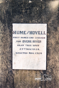
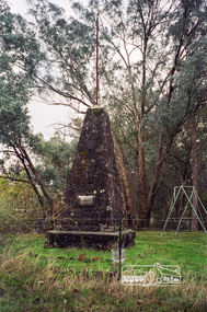
Photograph, Hume and Hovell Monument, Back Creek Road, old Back Creek school site, Back Creek, c.1998, 1998c
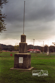
... Thirty-three monuments or cairns were erected at Violet Town, Euroa, Avenel, Seymour, Broadford, Kilmore, Mount Bland, Bulla, Moyhu, Hansonville, Benalla, Samaria, Swanpool, Yarck, Yea, The Horn (Buffalo), Myrtleford, Whorouly, Everton, Murmungee, Stanley, Back Creek, Allan's Flat, Staghorn Flat, Ebden, Bethanga, Hume Reservoir, Strath Creek, Deer Park, Werribee, Lara, Bulla, Everton. activities back creek hume and hovell monument Kodak Gold 200-6 Roll of 35mm colour negative film, 7 strips Hume and Hovell Monument, Back Creek Road, old Back Creek school site, Back Creek, c.1998 Photograph ...Stage 3 tour of Hume and Hovell monuments organised by Russell Yeoman. At the centenary of Hume and Hovell exploration in 1924 a committee was formed to co-ordinate and organise local celebrations along the route from Albury to Corio Bay. An itinerary was created for the unveiling ceremonies giving the hour and date for each place concerned from 15 to 21 November 1924. Thirty-three monuments or cairns were erected at Violet Town, Euroa, Avenel, Seymour, Broadford, Kilmore, Mount Bland, Bulla, Moyhu, Hansonville, Benalla, Samaria, Swanpool, Yarck, Yea, The Horn (Buffalo), Myrtleford, Whorouly, Everton, Murmungee, Stanley, Back Creek, Allan's Flat, Staghorn Flat, Ebden, Bethanga, Hume Reservoir, Strath Creek, Deer Park, Werribee, Lara, Bulla, Everton.Roll of 35mm colour negative film, 7 stripsKodak Gold 200-6activities, back creek, hume and hovell, monument -
 Eltham District Historical Society Inc
Photograph, Hume and Hovell Monument, Memorial Park Sports Ground, Whorouly, c.1998, 1998c
... Thirty-three monuments or cairns were erected at Violet Town, Euroa, Avenel, Seymour, Broadford, Kilmore, Mount Bland, Bulla, Moyhu, Hansonville, Benalla, Samaria, Swanpool, Yarck, Yea, The Horn (Buffalo), Myrtleford, Whorouly, Everton, Murmungee, Stanley, Back Creek, Allan's Flat, Staghorn Flat, Ebden, Bethanga, Hume Reservoir, Strath Creek, Deer Park, Werribee, Lara, Bulla, Everton. activities back creek hume and hovell monument Kodak Gold 200-6 Roll of 35mm colour negative film, 7 strips Hume and Hovell Monument, Memorial Park Sports Ground, Whorouly, c.1998 Photograph ...Stage 3 tour of Hume and Hovell monuments organised by Russell Yeoman. At the centenary of Hume and Hovell exploration in 1924 a committee was formed to co-ordinate and organise local celebrations along the route from Albury to Corio Bay. An itinerary was created for the unveiling ceremonies giving the hour and date for each place concerned from 15 to 21 November 1924. Thirty-three monuments or cairns were erected at Violet Town, Euroa, Avenel, Seymour, Broadford, Kilmore, Mount Bland, Bulla, Moyhu, Hansonville, Benalla, Samaria, Swanpool, Yarck, Yea, The Horn (Buffalo), Myrtleford, Whorouly, Everton, Murmungee, Stanley, Back Creek, Allan's Flat, Staghorn Flat, Ebden, Bethanga, Hume Reservoir, Strath Creek, Deer Park, Werribee, Lara, Bulla, Everton.Roll of 35mm colour negative film, 7 stripsKodak Gold 200-6activities, back creek, hume and hovell, monument -
 Eltham District Historical Society Inc
Photograph, Hume and Hovell Monument, Back Creek Road, old Back Creek school site, Back Creek, c.1998, 1998c
... Thirty-three monuments or cairns were erected at Violet Town, Euroa, Avenel, Seymour, Broadford, Kilmore, Mount Bland, Bulla, Moyhu, Hansonville, Benalla, Samaria, Swanpool, Yarck, Yea, The Horn (Buffalo), Myrtleford, Whorouly, Everton, Murmungee, Stanley, Back Creek, Allan's Flat, Staghorn Flat, Ebden, Bethanga, Hume Reservoir, Strath Creek, Deer Park, Werribee, Lara, Bulla, Everton. Activities Back Creek Hume and Hovell Monument Kodak Gold 200-6 Roll of 35mm colour negative film, 7 strips Hume and Hovell Monument, Back Creek Road, old Back Creek school site, Back Creek, c.1998 Photograph ...Stage 3 tour of Hume and Hovell monuments organised by Russell Yeoman. At the centenary of Hume and Hovell exploration in 1924 a committee was formed to co-ordinate and organise local celebrations along the route from Albury to Corio Bay. An itinerary was created for the unveiling ceremonies giving the hour and date for each place concerned from 15 to 21 November 1924. Thirty-three monuments or cairns were erected at Violet Town, Euroa, Avenel, Seymour, Broadford, Kilmore, Mount Bland, Bulla, Moyhu, Hansonville, Benalla, Samaria, Swanpool, Yarck, Yea, The Horn (Buffalo), Myrtleford, Whorouly, Everton, Murmungee, Stanley, Back Creek, Allan's Flat, Staghorn Flat, Ebden, Bethanga, Hume Reservoir, Strath Creek, Deer Park, Werribee, Lara, Bulla, Everton.Roll of 35mm colour negative film, 7 stripsKodak Gold 200-6activities, back creek, hume and hovell, monument -
 Bendigo Historical Society Inc.
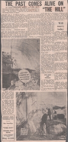
Newspaper - VICTORIA HILL - VICTORIA HILL NEWSPAPER ARTICLE
... History House 11 Mackenzie Street Bendigo goldfields NEWSPAPER Bendigo advertiser Victoria Hill Victoria Hill Newspaper Article Central Deborah Victoria Hill Open Cut Joss House Bendigo Potteries Mr A E Richardson Bendigo Historical Society Mr J Hattam Reservoir High School Mr W J Derham Rotary Club of Bendigo South Bendigo and District Tourist Association Victoria Quartz Mine George Lansell's Big 180 Theodore Ballerstedt Goldmines Hotel Two copies of newspaper articles titled ''The Past Comes Alive on 'The Hill'' from the Bendigo Advertiser dated 3/7/1971. ...Two copies of newspaper articles titled ''The Past Comes Alive on 'The Hill'' from the Bendigo Advertiser dated 3/7/1971. Some history, a guided tour by two busloads of students and some plans are mentioned in the article. There are also two photos in the article. In one photo three Rotarians of Bendigo South, Mr. Vic Wodetski, Mr. Jack Bright and Mr. A. E. Richardson are inspecting some of the concentric rings of iron oxide and the quartz spur running through the centre of the outcrop on Victoria Hill. In the other photo Mr. jack Bright is looking at the natural curves of colour in the stone of Victoria Hill.newspaper, bendigo advertiser, victoria hill, victoria hill newspaper article, central deborah, victoria hill open cut, joss house, bendigo potteries, mr a e richardson, bendigo historical society, mr j hattam, reservoir high school, mr w j derham, rotary club of bendigo south, bendigo and district tourist association, victoria quartz mine, george lansell's big 180, theodore ballerstedt, goldmines hotel -
Glenelg Shire Council Cultural Collection
Functional object - Whale Oil Lamp, n.d
... Circular base, stand with carry handle. 7 cm tall amber glass oil reservoir, protected by brass strips, wick burner on top....Circular base, stand with carry handle. 7 cm tall amber glass oil reservoir, protected by brass strips, wick burner on top. ...Antique brass whale oil lamp. Circular base, stand with carry handle. 7 cm tall amber glass oil reservoir, protected by brass strips, wick burner on top. -
 Bendigo Historical Society Inc.
Newspaper - Newspaper articles by Ken Arnold, Hindsights, 1999 - 2001
... 7. Local Heroes Nov. 2001 8. Golden Days in the Borough Nov. 2001 9. Fortuna Villa July 2000 10. Marong Shire Councilors Aug. 2000 11. Crusoe Reservoir...7. Local Heroes Nov. 2001 8. Golden Days in the Borough Nov. 2001 9. Fortuna Villa July 2000 10. Marong Shire Councilors Aug. 2000 11. Crusoe Reservoir ...Ken Arnold is a Bendigo author and publisher.A series of thirty-three articles written by Ken Arnold and published in the Bendigo Weekly between 1999 and 2001. Each article has a Bendigo topic or theme and includes historical information and details. Each article includes a photograph. The articles are stored in a white vinyl covered two ring A5 folder. Index below. Number Article Name Date 1. Gold and Break o’ Day Aug. 2001 2. Millewa Hall, Bendigo Railway Line Feb. 2001 3. St Mary the Virgin Church Oct. 2001 4. Old Flour Mill Nov. 2000 5. Woodstock on Loddon Dec. 2000 6. Women Find Gold Aug. 2001 7. Local Heroes Nov. 2001 8. Golden Days in the Borough Nov. 2001 9. Fortuna Villa July 2000 10. Marong Shire Councilors Aug. 2000 11. Crusoe Reservoir Sept. 2000 12. Early House Oct. 2000 13. Kangaroo Flat State School ‘Annex’ Nov. 2000 14. No 7 Claims two lives – 1865 Aug. 2000 15. Lockwood School Aug. 2002 16. Happy Jack’s Store July 2002 17. Last Bills Water Trough in Town Feb. 2002 18. Bonhaven & the Petherick’s Apr. 2002 19. Temperance Brewery Oct. 1999 20. Queen’s Head Hotel Nov. 1999 21. Victoria Store Dec. 1999 22. Victoria House Feb. 2000 23. Nankervis Bacon Factory March 2000 24. Ye Olde Grocery Shoppe April 2000 25. Marong Council May 2000 26. City Brewery June 2000 27. New Era for Old Pub 28. Kangaroo Flat Railway Station May 2002 29. Miner’s Charade 30. The Wiegard Bros Part 2 Mar 2002 31. The Wiegard Bros Part 3 32. Kangaroo Flat to Crusoe 33. Local History, California Gully monuments, historical sites, buildings, people -
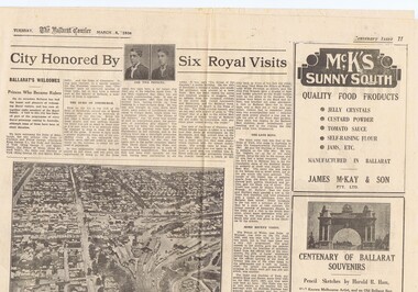 Ballarat Tramway Museum
Newspaper, The Courier Ballarat, City Honored by six Royal Visits, Mar. 1938
... Reservoir and Committeemen of the Ballarat Horticultural Society - 1859 to 1885. Ads for Ballarat College, Clarendon, Queens (girls) and Ballarat Grammar schools, Ern Craig Motors (Vauxhall) and Snows men's wear. Record reviewed and images of pages added 7...Reservoir and Committeemen of the Ballarat Horticultural Society - 1859 to 1885. Ads for Ballarat College, Clarendon, Queens (girls) and Ballarat Grammar schools, Ern Craig Motors (Vauxhall) and Snows men's wear. Record reviewed and images of pages added 7 ...Yields information about Ballarat and its locations or environs late 1938.Pages 11,12, 19 and 20 of the centenary of settlement in the Ballarat district by the Ballarat Courier - March 1938. See also items 186, 198 and 199. Page 11 Royal visits, banking in Ballarat, photos - NW section of Ballarat, railway station in foreground. Ads for J.McKay and Son, Roy Reeds (Men's store) and Ballarat Gas Co. Also photo of "The Corner" in Sturt St. - old Mining Exchange. Page 12 - full page ad for Morseheads, women's store. Page 19 - articles - Ballarat Lighting and Power, ESCo, SEC, electric trams. photos of the Arch of Victory, first electric tram, Lake Wendouree. Advertisements for Austin Spears (cycles), McDougall and Chisholm (drapers), W.E. Longhurst (bread) and the ES&A bank. Also article on South St. Society - music and elocution. Page 20 - articles - Ballarat Gas Co., horse and electric trams, agriculture in district and Ballarat's war record (WWI). Photos of work at Gong Gong Reservoir and Committeemen of the Ballarat Horticultural Society - 1859 to 1885. Ads for Ballarat College, Clarendon, Queens (girls) and Ballarat Grammar schools, Ern Craig Motors (Vauxhall) and Snows men's wear. Record reviewed and images of pages added 7-9-2013 and 10-9-2013trams, tramways, ballarat electricity, centenary, banking, transport, trams, esco -
 Melbourne Tram Museum
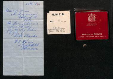
Ephemera - Personal Papers in a Benson & Hedges tin, 1950s
... Reservoir showing a balance of 1pound and 10 shillings - hire purchase? - dated 21/9/1950 6 - Receipt from Bruce Small Pty Ltd for payment of 15 pounds, a/c Bicycle finance - with a Victorian 2d duty stamp, dated 8/4/1952 7 - Interim receipt for 5 pounds from the Lalor Consumer Co-op dated 26-9-1950 At the time Mr Yoemans lived in Gratwick St Lalor....Reservoir showing a balance of 1pound and 10 shillings - hire purchase? - dated 21/9/1950 6 - Receipt from Bruce Small Pty Ltd for payment of 15 pounds, a/c Bicycle finance - with a Victorian 2d duty stamp, dated 8/4/1952 7 - Interim receipt for 5 pounds from the Lalor Consumer Co-op dated 26-9-1950 At the time Mr Yoemans lived in Gratwick St Lalor. ...Allan Yoemans was a tramway employee at Preston depot. Receipts contained within the Benson and Hedges tin of the early 1950s noting it is by appointment to HM King George V are: 1 - Receipt for a ladies cycle - 9 pounds - dated 2/11/1957 2 - MMTB clothing docket for a coat - size 6 3 - Receipt on MMTB letterhead and docket - payment of Tramway Benefit Society subscription - dated 3/12/1956 - received at Preston Revenue office 4 - Receipt for 170 pounds - payment for a Chev sedan car with a Victorian 3d duty stamp, dated 13-4-53 5 - Receipt for payment of 4/6, Ezyart Co of Reservoir showing a balance of 1pound and 10 shillings - hire purchase? - dated 21/9/1950 6 - Receipt from Bruce Small Pty Ltd for payment of 15 pounds, a/c Bicycle finance - with a Victorian 2d duty stamp, dated 8/4/1952 7 - Interim receipt for 5 pounds from the Lalor Consumer Co-op dated 26-9-1950 At the time Mr Yoemans lived in Gratwick St Lalor.Shows business practices of the early 1950s and the way payments such as hire purchase could be made and receipted, including payments to the Tramway Benefit Society.Metal tin or cigarette container - red for 20 Benson & Hedges cigarettes containing 7 paper receipts or dockets.tramway benefit society, tbs, receipts, financial records, tramway employee -
 Bendigo Regional Archives Centre
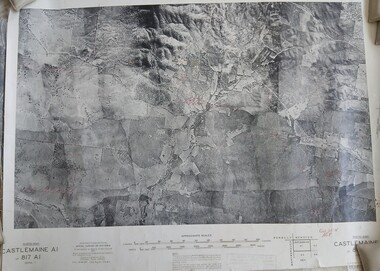
Photograph (item) - Set of 8 1945 B& W Photomaps, mounted on linen, most with geological annotations, as follows: Castlemaine A1, 817 A1, Zone 7, 1945; Bendigo A2 -Eaglehawk Aqueduct, Bullock Creek and Lockwood; Bendigo A4, 807 A4, Zone 7, 1945; Bendigo B1 - Golden Square, Kangaroo Flat, Splitters Creek, Strathfieldsaye Creek, Sheepwash Creek, Spring Gully Reservoir; Bendigo B3, 807 B3, Zone 7, 1945; Bendigo C3, 807 C3, Zone 7, 1945; Bendigo D3, 807 D3, Zone 7, 1945; Huntly C4 - Eaglehawk, Marong, Myers Flat, 1945
... Set of 8 1945 B& W Photomaps, mounted on linen, most with geological annotations, as follows: Castlemaine A1, 817 A1, Zone 7, 1945; Bendigo A2 -Eaglehawk Aqueduct, Bullock Creek and Lockwood; Bendigo A4, 807 A4, Zone 7, 1945; Bendigo B1 - Golden Square, Kangaroo Flat, Splitters Creek, Strathfieldsaye Creek, Sheepwash Creek, Spring Gully Reservoir; Bendigo B3, 807 B3, Zone 7, 1945; Bendigo C3, 807 C3, Zone 7, 1945; Bendigo D3, 807 D3, Zone 7, 1945; Huntly C4 - Eaglehawk, Marong, Myers Flat...Set of 8 1945 B& W Photomaps, mounted on linen, most with geological annotations, as follows: Castlemaine A1, 817 A1, Zone 7, 1945; Bendigo A2 -Eaglehawk Aqueduct, Bullock Creek and Lockwood; Bendigo A4, 807 A4, Zone 7, 1945; Bendigo B1 - Golden Square, Kangaroo Flat, Splitters Creek, Strathfieldsaye Creek, Sheepwash Creek, Spring Gully Reservoir; Bendigo B3, 807 B3, Zone 7, 1945; Bendigo C3, 807 C3, Zone 7, 1945; Bendigo D3, 807 D3, Zone 7, 1945; Huntly C4 - Eaglehawk, Marong, Myers Flat...Phtotomap Printed aerial photographs mounted on linen Set of 8 1945 B& W Photomaps, mounted on linen, most with geological annotations, as follows: Castlemaine A1, 817 A1, Zone 7, 1945; Bendigo A2 -Eaglehawk Aqueduct, Bullock Creek and Lockwood; Bendigo A4, 807 A4, Zone 7, 1945; Bendigo B1 - Golden Square, Kangaroo Flat, Splitters Creek, Strathfieldsaye Creek, Sheepwash Creek, Spring Gully Reservoir; Bendigo B3, 807 B3, Zone 7, 1945; Bendigo C3, 807 C3, Zone 7, 1945; Bendigo D3, 807 D3, Zone 7, 1945; Huntly C4 - Eaglehawk, Marong, Myers Flat Photograph Set of 8 1945 B& W Photomaps, mounted on linen, most with geological annotations, as follows: Castlemaine A1, 817 A1, Zone 7, 1945; Bendigo A2 -Eaglehawk Aqueduct, Bullock Creek and Lockwood; Bendigo A4, 807 A4, Zone 7, 1945; Bendigo B1 - Golden Square, Kangaroo Flat, Splitters Creek, Strathfieldsaye Creek, Sheepwash Creek, Spring Gully Reservoir; Bendigo B3, 807 B3, Zone 7, 1945; Bendigo C3, 807 C3, Zone 7, 1945; Bendigo D3, 807 D3, Zone 7, 1945; Huntly C4 - Eaglehawk, Marong, Myers Flat ...Phtotomap -
Box Hill Historical Society
Photograph - Aerial view of the reservoir in Canterbury Road
... Box Hill Historical Society Box Hill Heritage Centre Suite 7 Town Hall Hub Box Hill melbourne Aerial view of the reservoir in Canterbury Road. ...Aerial view of the reservoir in Canterbury Road. The photo is looking south over Surrey Hills and the telecommunication tower.aerial photographs, canterbury road, surrey hills, telecommunications equipment -
 Box Hill Historical Society
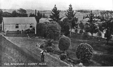
Photograph - Reservoirs
... Box Hill Historical Society Box Hill Heritage Centre Suite 7 Town Hall Hub Box Hill melbourne The Reservoir in Surrey Hills. ...The Reservoir in Surrey Hills. It shows someone working in the garden in the foreground and a shed on the lefthand side of the picture. This could be either the reservoir in Canterbury Road or the one in Elgar Road.B&w photosurrey hills, dams and reservoirs -
Box Hill Historical Society
Photograph - Box Hill Reservoir, 1908-1910
... Box Hill Historical Society Box Hill Heritage Centre Suite 7 Town Hall Hub Box Hill melbourne Construction of Box Hill Reservoir, corner of Canterbury and Elgar Roads. 1908-1910. ...Construction of Box Hill Reservoir, corner of Canterbury and Elgar Roads. 1908-1910. See further information on B0226.B&w photoOn back of original photograph. CONSTRUCTION OF BOX HILL RESERVOIR ELGAR ROAD 1908-1910.box hill reservoir, dams and reservoirs, muldoon> owen -
Box Hill Historical Society
Photograph - Box Hill Reservoir, 1908-1910
... Box Hill Historical Society Box Hill Heritage Centre Suite 7 Town Hall Hub Box Hill melbourne Construction of Box Hill Reservoir, corner of Canterbury and Elgar Roads, 1908--1910. ...Construction of Box Hill Reservoir, corner of Canterbury and Elgar Roads, 1908--1910. See further information on this series on B0226.B&w photoOn back of original photograph - CONSTRUCTION OF BOX HILL RESERVOIR ELGAR ROAD 1908-1910.box hill reservoir, dams and reservoirs, muldoon> owen -
 Box Hill Historical Society
Photograph - Box Hill Reservoir, 1908-1910
... Box Hill Historical Society Box Hill Heritage Centre Suite 7 Town Hall Hub Box Hill melbourne Construction of Box Hill Reservoir, corner of Canterbury and Elgar Roads, 1908-1910. ...Construction of Box Hill Reservoir, corner of Canterbury and Elgar Roads, 1908-1910. See further details on B0226.B&w photoOn back of original photograph - CONSTRUCTION OF BOX HILL RESERVOIR ELGAR ROAD 1908-1910.box hill reservoir, dams and reservoirs, muldoon> owen