Showing 35 items matching " north park service station"
-
 Glen Eira Historical Society
Newsletter - St Patrick’s Roman Catholic Church, Murrumbeena
... Service Station... Hughesdale dairy... Frank Benham butcher... P.H.M Pty. Ltd. Estate Agents & Auctioneers... Regina Ladies’ and Children’s wear... Terminus Florist... Youngman’s Furniture... John P. Hannan Chemist... A.C Eastburn... Coles and Garrard Pty. Ltd. Sight Testing... St Patrick’s Roman Catholic Church Murrumbeena... Martin Brothers... Rice’s Milk Bar... Margot Beauty Salon... Total Service Station... Alex Woodland licensed food centre... Murrumbeena Hardware... L & J Barclay boys’ & men’s wear... North Park...Service Station Hughesdale dairy Frank Benham butcher P.H.M Pty. Ltd. Estate Agents & Auctioneers Regina Ladies’ and Children’s wear Terminus Florist Youngman’s Furniture John P. Hannan Chemist A.C Eastburn Coles and Garrard Pty. Ltd. Sight Testing St Patrick’s Roman Catholic Church Murrumbeena Martin Brothers Rice’s Milk Bar Margot Beauty Salon Total Service Station Alex Woodland licensed food centre Murrumbeena Hardware L & J Barclay boys’ & men’s wear North Park Service Station Templer’s Milk Bear W.M & S.R Jamieson delicatessen & grocer Pearlee Products Payne’s Milk Bar Mick Dillon master plumber L.C & K.A Styles authorised newsagents Brian F. ...There are two copies of Tara Light, St Patrick’s Murrumbeena church newsletter. The first one is from November 1969 and the second is April 1971. Both newsletter contain brief history of the church and lists of people and businesses that advertised in Tara Light. For both copies, there is a picture of the church exterior on the front page. The second document is an order of service for an Inter Church advent service at St Patrick’s Catholic Church. The particular service was done on 17/12/1987. There are 30 varying illustrations inside the order of service.rovira william rev., caulfield, graloav max, quillinan james rev., cremin patrick, spencer tracy, dalny road, glen huntly, van langenber jeremy, lowe ron rev., murrumbeena, blow walda, parish, churches, advertisements, the tribune, the advocate, hodgson wilma, matthew f, rosaleen sister, whelan joan, daniel f mrs., tesoriero l mr., buckley gerald, bruce alan, tara light, findley’s 4 square self service licenced grocery., tobin brothers funeral directors, hudson’s service station, hughesdale dairy, frank benham butcher, p.h.m pty. ltd. estate agents & auctioneers, regina ladies’ and children’s wear, terminus florist, youngman’s furniture, john p. hannan chemist, a.c eastburn, coles and garrard pty. ltd. sight testing, st patrick’s roman catholic church murrumbeena, martin brothers, rice’s milk bar, margot beauty salon, total service station, alex woodland licensed food centre, murrumbeena hardware, l & j barclay boys’ & men’s wear, north park service station, templer’s milk bear, w.m & s.r jamieson delicatessen & grocer, pearlee products, payne’s milk bar, mick dillon master plumber, l.c & k.a styles authorised newsagents, brian f. goodman chemist, moody pty. ltd. estate agents & auctioneers, gerry butler insurance consultant, commando printing services -
 Eltham District Historical Society Inc
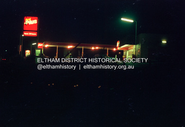
Photograph (Item) - Negative, Mathew Wakefield, Eltham Community Photographic Survey Entry, 1988
... It is a time capsule of life in the 1980s of this urban and rural municipality in Melbourne's north. shire of eltham archives Bicentennial Project Eltham Community Photographic Survey Dalton Street Eltham Film - Fuji 100 Main Road Mathew Wakefield Scan - 35mm negative Series 35 Wiingrove Park Trail Yarra River Beard Street Food Plus Service Station Colour 35mm film strip - Fuji 100 Eltham Community Photographic Survey Entry Photograph Negative Mathew Wakefield ...Mathew Wakefield 1988 Entrant No. 40 Ref: Series 34, Items 87, 88 The images in this record were not selected for inclusion. SHIRE OF ELTHAM COMMUNITY PHOTOGRAPHIC SURVEY Photography is an artform which many of us practice, sometimes purely for artistic pursuit, sometimes to record the people and events in our lives. In 1988, as part of a local Bicentennial project, the Shire of Eltham conducted the Eltham Community Photographic Survey. Up to 100 entries were to be selected by a panel of photographers for entry into the Eltham Photographic Survey Exhibition. Entries had to be submitted by May 13, 1988. Entrants whose images were selected for the exhibition were contacted and requested to further submit an entry form providing entrant’s name, area of residence, age, and proposed captions. These details were then used to produce labels for the exhibition mounts. Where negatives had not been supplied, these were requested to support the display of printed enlargements mounted on 10” x 8” cardboard. The mounted prints were made available post exhibition for sale at $8.50 each for colour prints and $7.00 for B&W prints. Residents in the Shire were invited to collect a free roll of film and take a photograph of what they either liked or did not like about the area. A total of 160 entrants submitted multiple entries for the exhibition. Of those selected for exhibition, entrants ranged in age from 9 to 70 years. All custom colour and black and white printing for the exhibition was completed by Wattle Studios of Eltham. The Eltham Photographic Survey was jointly auspiced by the Shire of Eltham and Wattle Studios, of 953 Main Road, Eltham. The project was greatly assisted by: • David McRitchie, Media Studies Lecturer Victoria College, Rusden Campus. • Ian and Annette Toohill of Wattle Studios • Tracy Naughton, Eltham Community Arts Officer • Neville Emerson Pty. Ltd. • Superior Press, Eltham • Kodak Australasia Pty. Ltd. • Agfa Gevaert Ltd. • Townsend Colourtech Pty. Ltd. • The Australian Bicentennial Authority • Eleanor Bowers, Secretary, Eltham Arts Council The exhibition was placed on display in the Woolworths Arcade, Eltham between Monday June 6th and Saturday June 11, 1988. It was also intended to hold the exhibition at a venue in the Shire’s North Riding from Monday, June 20 to Friday June 24. It was then displayed at the Were Street Theatre, Montmorency from Friday, June 24 to Thursday, July 7. Series 34: Eltham Community Photographic Survey 1988 - Prints & Documentation Series consists of 117 photographs of Shire scenes taken by members of the community. Items I - 41 are larger photographs mounted on card, which were exhibited. Items 42 - 117 are unmounted copies, alternative takes and other entries. Corresponding negatives contained in Series 35: Eltham Community Photographic Survey 1988 – Negatives which consists of 267 colour and B&W negatives and one colour slide of Shire scenes taken by members of the community. The negatives are arranged by the entrant number of the photographer. The Eltham Community Photographic Survey collection is significant to the local community as it was curated by the local community - ordinary people of all ages - representing what they liked and did not like in the area where they lived. It represents an unfiltered representation of the Shire of Eltham as it was in 1988. It also represents one of many projects as part of the national programme of events and celebrations to commemorate the bicentenary. It is a time capsule of life in the 1980s of this urban and rural municipality in Melbourne's north. shire of eltham archives, bicentennial project, eltham community photographic survey, dalton street, eltham, film - fuji 100, main road, mathew wakefield, scan - 35mm negative, series 35, wiingrove park trail, yarra river, beard street, food plus service station -
Glen Eira Historical Society
Document - Racing Stables In Caulfield
... North... Caulfield South... Carnegie... Glen Huntly... Glenhuntly... Eskdale Road... Balaclava Road... Bambra Road... Glen Eira Road... Heywood Street... Hudson Street... Hawthorn Road... Kambrook Road... Kooyong Road... Tudor Court... Lloyds Paddock... Payne Street... Park Crescent... Service Street... Slaney’s Paddock... Station...Caulfield Caulfield North Caulfield South Carnegie Glen Huntly Glenhuntly Eskdale Road Balaclava Road Bambra Road Glen Eira Road Heywood Street Hudson Street Hawthorn Road Kambrook Road Kooyong Road Tudor Court Lloyds Paddock Payne Street Park Crescent Service Street Slaney’s Paddock Station Street Booran Road ‘Moidart’ Cadby Court Glen Huntly Road Glenhuntly Road Neerim Road ‘Cintra’ Stephen Street Uranda Line Grove Willgra Road Epsom Street Lloyds Street Lord Street Queens Avenue St Vincents Street Roseberry Grove Manchester Grove Safeway Supermarket Hesop G. ...This file contains 3 items. 1/ Document provided by Veterinarian Dr G. G. Heslop about racing stables in the Caulfield area adjacent to the Caulfield Race Course, in both typed and handwritten form. 2/ A letter of request from a Sydney based sports writer Geoff Armstrong for information about the attempted shooting for Phar Lap. 3/ A letter to the Editor in the Glen Eira/Port Phillip Leader dated 02/04/2013 about the proposal to ban horse training from the Caulfield Racecourse.clubs and associations, victorian amateur turf club, racecourses, caulfield race course, racecourse trainers, stables, racehorses, schools, secondary school, caulfield high school, hotels, caulfield club hotel, wattle tree hotel, petrol stations, veterinarian clinic, norman myers veterinarian hospital, baker norma, bence j., bird j., cadby lou, conaghan basil, cameron ron, couseng harry, cox cecil, creighton norman, delaney g., eules darce, farmer h. (dick), fraser mick, foulsham fred, fryer j., gatell harry, garton a. (rod), garland f., godby cecil, godby frank, goodfellow claude, guinane p., hayes t. j., hilton h., hodgkinson george, james jack, jenkins e. j., jennings reg, judd des, jury jack, king frank, mcgregor j. n., mcnamara dave, mcphee sonny, mclaughlin, mulcahy j., murphy geoff, muskett j., parkinson j., phillipson mr., quinlan pat, ralph stan, reid stanley, robinson f., rolfe w. j., sanderson chris, telford w., tie jerry, torr harry, bernborough, black caviar, garryowen, phar lap, purser, revenue, spearfelt, surround, arthur jr., murrel violet, farmer violet, kemball w. r., mcdonald leslie, brockhoff mr., carslake mr., gullifer h., heywood j. g., llord mr., davies mr., palfreman mr., caulfield, caulfield north, caulfield south, carnegie, glen huntly, glenhuntly, eskdale road, balaclava road, bambra road, glen eira road, heywood street, hudson street, hawthorn road, kambrook road, kooyong road, tudor court, lloyds paddock, payne street, park crescent, service street, slaney’s paddock, station street, booran road, ‘moidart’, cadby court, glen huntly road, glenhuntly road, neerim road, ‘cintra’, stephen street, uranda line grove, willgra road, epsom street, lloyds street, lord street, queens avenue, st vincents street, roseberry grove, manchester grove, safeway supermarket, hesop g. g. dr veterinary surgeon -
Glen Eira Historical Society
Document - History of the City of Caulfield
... Mary’s Church Caulfield Council Kooyong Road Neerim Road Bambra Road Greenmeadows House Caulfield Park Paddy’s Swamp Dandenong Road Caulfield Grammar School Chisholm Institute of Technology Murrumbeena Glen Eira Road Alma Road Orrong Road Balaclava Road Inkerman Road ‘Grosmont’ Caulfield School Room Caulfield Road Board Caulfield Road District Crimean War Victorian Amateur Turf Club Caulfield Cup Glenhuntly Road North Road Glenhuntly Station Ormond Station Outer Circle Railway Local Government Gardenvale Carnegie Rosstown Poath Road Nepean Highway Hotham Street Ormond Park Princes Park Ross William Murray Caulfield Institute of Technology ‘Ross’ Folly’ Hawthorn Road Glenhuntly Ormond Morris T. W. Lloyd Charles Du Plan Meals on Wheels Shire of Caulfield Caulfield Railway Station Caulfield RSL Bouran Road Murrum Murrumbeen Kooyong Road Great Dandenong Road Neerim Road Trams Prahran and Malvern Tramways Trust Fisher Andrew MacKinnon Reserve Dover Street ‘Glen Eira’ Blair Max Cr. Insignia Third Ordnance Services ...This file contains 4 items: 1/Typewritten document titled ‘The City of Caulfield’. Author and date unknown. 1 page (back and front), 2 copies. Document covers topics such as origins of the name ‘Caulfield’, early settlement and the Caulfield Cup. 2/Typewritten document titled ‘History of Caulfield Council’. Author and date unknown. 6 pages, 3 copies. Document covers subjects such as early settlement, Aboriginal influence, Caulfield Road Board, Shire of Caulfield, Borough and town boundaries, coat of arms, and Freedom of Entry to the City. 3/Typewritten document (undated + author unknown) titled ‘The Structure of Local Government in Victoria with a history of the City of Caulfield’. 13 pages. Covers the following subjects: Powers, Planning, Public Works, Trading Undertakings, Health Services, Municipalities, Wards Electors or Ratepayers, Voters Roll, Councillors, Officers, Finance, Nature of Soil and Vegetation, Parks and Gardens and Reserves, Coat of Arms, Boundaries, How Did Caulfield get its Name, Aboriginal Influence, Caulfield Road Board, Shire of Caulfield, Borough and Town and the City of Caulfield. Also covered is early settlement. Note at the end of the document mentions that the historical content contained in the last section was based upon a thesis for the Department of Town and Regional Planning, University of Melbourne, 1968 by L. Alwis, P. Rowe, N. Wootten. Melbourne, ‘City of Caulfield: An Illustrated City Report’. 4/Typewritten document (undated) titled ‘The Structure of Local Government in Victoria with notes on the history of the City of Caulfield’. 8 pages, 2 copies. This document also includes a map/diagram of the city with boundaries and wards showing locations of railway stations and parks. Document covers the structure of local government and its functions then goes on to focus on City of Caulfield with subjects similar to those covered in item 3. Document signed off by Deputy Town Clerk.city of caulfield, caulfield john, caulfield baron, caulfield racecourse, elsternwick, ripponlea, st. mary’s church, caulfield council, kooyong road, neerim road, bambra road, greenmeadows house, caulfield park, paddy’s swamp, dandenong road, caulfield grammar school, chisholm institute of technology, murrumbeena, glen eira road, alma road, orrong road, balaclava road, inkerman road, ‘grosmont’, caulfield school room, caulfield road board, caulfield road district, crimean war, victorian amateur turf club, caulfield cup, glenhuntly road, north road, glenhuntly station, ormond station, outer circle railway, local government, gardenvale, carnegie, rosstown, poath road, nepean highway, hotham street, ormond park, princes park, ross william murray, caulfield institute of technology, ‘ross’ folly’, hawthorn road, glenhuntly, ormond, morris t. w., lloyd charles du plan, meals on wheels, shire of caulfield, caulfield railway station, caulfield rsl, bouran road, murrum murrumbeen, kooyong road, great dandenong road, neerim road, trams, prahran and malvern tramways trust, fisher andrew, mackinnon reserve, dover street, ‘glen eira’, blair max cr., insignia, third ordnance services unit, schools, street lighting, lampriere, mr. bevan, the caulfield leader, davies j. henry, curraweena road, st. georges road, o’neill college, hope george, market gardens, koornang reserve, packer reserve, murrumbeena reserve, hopetoun gardens, greenmeadows gardens, mirambeena, caulfield technical college, hart john, langdon h. j., ‘rosecraddock’, judge webb, ‘crotonhurst’, service james, ‘kilwinning’, ricketson henry, grimwade frederick sheppard, airdrie, jenner, st. aubin’s, caulfield john p. t., harlston, lempriere, lord reserve, ‘cantala’ -
Glen Eira Historical Society
Document - KOOYONG ROAD, 75, CAULFIELD NORTH
... Services Unit Royal Australian Army Ordnance Corps Caulfield Park Caulfield Council North Caulfield Campton E.J. (Brigadier) Walters W.R. Mrs. Calder G.K. Calder G.K. Mrs. Mahon J. (Chief Superintendent) City Hall Balaclava Road Hawthorn Road Glen Eira Road Hartley Avenue Kooyong Road Caulfield Racecourse Caulfield Town Hall Alma Road Red Cheques Cab Company Army Headquarters Printing Press Searchlight Company Amenities Store Armoured Replacement Unit First Base Printing Company R.A.A.O.C. Garden Vale Caulfield Railway Station ...Two copies of a pamphlet for the ceremony of the Third Ordnance Services Unit ‘Exercising the Right of the Freedom of Entry to the City of Caulfield’ held on 23/10/1983. The pamphlet includes a brief history of the unit’s association with the City of Caulfield, a list of individuals holding posts within the Unit, text of the scroll conferring the Freedom of Entry on the Unit, a program of the ceremony, a brief history of the Royal Australian Army Ordnance Corps including the Unit’s use of 75 Kooyong Road as their premises, a brief history of the City of Caulfield from 1937-postwar years, and an explanation of the tradition of conferring Freedom of Entry to a city. The pamphlet includes also: 1/A black and white photograph (47x35mm) of the Mayor of Caulfield, W.R. Walters, undated and unattributed. 2/A black and white photograph (81x69mm) of Major A.G. Storen, Commanding Officer of the Third Ordnance Services Unit, undated and unattributed. 3/A color photograph (88x84mm) of the Sovereign’s Banner, undated and unattributed. 4/A black and white copy (137x87mm) of the scroll conferring Freedom of Entry into the City of Caulfield, which was seated August 4 1978. 5/A color illustration (30x32mm) of the City of Caulfield Coat of Arms. 6/A color illustration (40x32mm) of the Third Ordnance Services Unit, Royal Australian Army Ordnance Corps Coat of Arms. 7/A black and white illustration (21x24mm) of the city of Caulfield Coat of Arms. 8/A black and white illustration (19x14mm) of the City of Caulfield badge. 9/A black and white illustration (22x31mm) of the City of Caulfield banner.walters w.r., storen a.g. major, finning d.j. captain, hately p.g. major, davidson j. (captain), swendson r. (second lieutenant), caulfield, city of caulfield, australian army, the third ordnance services unit royal australian army ordnance corps, caulfield park, caulfield council, north caulfield, campton e.j. (brigadier), walters w.r. mrs., calder g.k., calder g.k. mrs., mahon j. (chief superintendent), city hall, balaclava road, hawthorn road, glen eira road, hartley avenue, kooyong road, caulfield racecourse, caulfield town hall, alma road, red cheques cab company, army headquarters printing press, searchlight company, amenities store, armoured replacement unit, first base printing company r.a.a.o.c., garden vale, caulfield railway station, paddy’s swamp, great dandenong road, glen ferrie road, dandenong road, east caulfield reserve, caulfield military hospital, ‘glen eira’, town hall, ‘war office’, caulfield district road board, shire of caulfield, caulfield recruiting committee for volunteers, city repatriation committee, red cross emergency service, women’s national service, mayor’s patriotic fund, promotions committee for war savings certificates, war savings group scheme, ‘the gazette’, air raid precautions committee, orrong road, armed forces, world war 1939-1945, local government, parades and processions, military reserves, world war 1914-1918, councillors, events and activities, historic events, official events, caulfield john, wyne agar, murphy (mayor), hale p., ison (captain), fisher andrew, morris t.w. (mayor) -
Glen Eira Historical Society
Document - KOOYONG ROAD, 75, CAULFIELD NORTH
... (Mayor) Caulfield Kooyong Road Caulfield Park North Caulfield City of Caulfield City Hall Balaclava Road Hawthorn Road Glen Eira Road Hartley Avenue Caulfield Racecourse Caulfield Town Hall Alma Road Orrong Road Garden Vale Caulfield Railway Station Paddy’s Swamp Great Dandenong Road Glen Ferrie Road Dandenong Road East Caulfield Reserve Caulfield Military Hospital ‘Glen Eira’ Town Hall ‘War Office’ Red Chequer Cab Company Caulfield Council Third Ordnance Services Unit Royal Australian Army Ordnance Corps Australian Army Army Headquarters Printing Press Searchlight Company Amenities Store Armoured Replacement Unit First Base Printing Company R.A.A.O.C. ...Three copies of a pamphlet for the ceremony of the Third Ordnance Services Unit ‘Exercising the Right of the Freedom of Entry to the City of Caulfield’, held on 13/07/1986. The pamphlet includes a brief history of the Unit’s association with the City of Caulfield, a list of individuals holding posts within the unit, text of the scroll conferring the Freedom of Entry on the Unit, a program of the ceremony, a brief history of the Royal Australian Army Ordnance Corps, including the Unit’s use of 75 Kooyong Road as their premises, a brief history of the city of Caulfield and an explanation of the tradition of conferring Freedom of Entry to a city. The pamphlet includes also: 1/A black and white photograph (61x66mm) of the Mayor of Caulfield, Maxwell Blair, undated and unattributed. 2/A black and white photograph (70x51mm) of Major P.G. Hateley, Commanding Officer of the Third Ordnance Services Unit, undated and unattributed. 3/A black and white photograph (91x90mm) of the Sovereign’s Banner, undated and unattributed. 4/A black and white copy (137-87) of the scroll conferring Freedom of Entry into the City of Caulfield which was seated August 4 1978. 5/A color illustration (30x32mm) of the City of Caulfield Coat of Arms. 6/A colour illustration (40x32mm) of the Third Ordnance Services Unit, Royal Australian Army Ordnance Corps Coat of Arms. 7/A black and white illustration (21x24mm) of the City of Caulfield Coat of Arms. 8/A black and white illustration (19x19mm) of the City of Caulfield badge. 9/A black and white illustration (22x31mm) of the City of Caulfield banner.blair maxwell (mayor), hateley p.g. (major), finning d.j. (captain), lowe g. (captain), barker l.a. (lieutenant), blair mrs., aylen d.r., aylan d.r. mrs., goltz m.h., compton e.j. (brigadier), goltz m.h. (chief superintendant), caulfield john, wynne agar, murphy (mayor), hate p., ison (captain), fisher andrew, morris t.w. (mayor), caulfield, kooyong road, caulfield park, north caulfield, city of caulfield, city hall, balaclava road, hawthorn road, glen eira road, hartley avenue, caulfield racecourse, caulfield town hall, alma road, orrong road, garden vale, caulfield railway station, paddy’s swamp, great dandenong road, glen ferrie road, dandenong road, east caulfield reserve, caulfield military hospital, ‘glen eira’, town hall, ‘war office’, red chequer cab company, caulfield council, third ordnance services unit royal australian army ordnance corps, australian army, army headquarters printing press, searchlight company, amenities store, armoured replacement unit, first base printing company r.a.a.o.c., caulfield district road board, shire of caulfield, caulfield recruiting committee for volunteers, city repatriation committee, red cross emergency service, women’s national service, mayor’s patriotic fund, promotions committee for war savings certificates, war savings group scheme, ‘the gazette’, air raid precautions committee, armed forces, world war 1939-1945, local government, parades and processions, military reserves, world war 1914-1918, councillors, events and activities, historic events, official events -
Glen Eira Historical Society
Article - Grand Union Tramway Junction, Balaclava Road and Hawthorn Road
... Park Tram systems Tram networks Heritage Tramway Heritage Kings Keith Tram depots Glenhuntly Depot Maps Glen Eira Melbourne Electric Tramways North Melbourne Electric Tramways and Lighting Co. Prahran and Malvern Tramways Trust Caulfield Leader Bayside Weekly Tooke Craig Tourist attractions Grand Union Tramways Junction Caulfield Junction Cable Car Tramways Tram shelters Building Sheds Alma Road Orrong Road Caulfield Electric Line Balaclava Junction Elsternwick Railway Station Caulfield station Caulfield Station loop Tram services Transport establishments Thoroughfares Buildings Structures Establishments Parts of buildings or structures Documents Commercial industry Sites Historic sites Melbourne Bayside Weekly Article Grand Union Tramway Junction, Balaclava Road and Hawthorn Road ...This file contains three items. 1. A three-page Caulfield Conservation Study of the Balaclava Road/Hawthorn Road Tramway Crossing, undertake by Andrew Ward and dated September 1994. Study includes a brief history of the junction and a statement of significance. Study also includes Four black and white photographs of the junction and of architectural details of the tram tracks. 2. A letter from the Conservation Manager of the National Trust of Australia (Victoria) to the manager of the Planning Section for the City of Glen Eira, dated 15/06/2001 and attached to a six-page Classification Report. The letter informs of the Classification of the Grand Union Junction at the intersection of Balaclava and Hawthorn Road by the national trust, signed by Conservation Manager Ian Pausacker. Classification Report includes details such as the date of construction, a statement of significance, history of the junction, physical description of the junction and the condition of the junction at the time of writing. Report also includes a map of the Melbourne Tram Network drafted by Keith Kings and dated 01/005/1956, with illustration of the layout of fifteen tram depots, and updated aerial illustration of the Grand Union Junction, and a further map of Melbourne Tramways developed by North Melbourne Electric Tramways and Lighting Co. and Prahran and Malvern Tramways Trust, drafted by Keith Kings and dated January 1914 with illustrations of three tram depots. 3. Two articles from the Caulfield Leader written by Aaron Langmaid and dated 13/02/2007 and the Melbourne Bayside Weekly dated 21/02/2007 written by Joanne Sim, both concerning the Grand Union Junction. The article from the Caulfield Leader includes a picture of Executive Officer of the council of Tramway Museum of Australia Craig Tooke in front of the intersection. The article from the Bayside Weekly includes a picture of a tram passing through the junction and a brief history of the junction and tram network in Caulfield. The article also refers to twp local tram shelters at the intersection of Dandenong Road and Alma Road and also Orrong Road and Balaclava Road.caulfield, caulfield conservation, study, balaclava road, hawthorn road, grand union junction, ward andrew, tramway crossings, transport, acland street, caulfield racecourse, tram tracks, race events, event, tram routes, thorough fares, melbourne and metropolitan tramways board, prahran and malvern tramway trust, prahran and malvern district tramways, caulfield electric tramways, caulfield city council, architectural detail, city of glen eira, balaclava road and hawthorn road intersection, balaclava road and hawthorn road junction, dandenong road, glenhuntly road, four-way tram junctions, access covers darling road, cast metal access covers, hadfields patent, caulfield park, tram systems, tram networks, heritage, tramway heritage, kings keith, tram depots, glenhuntly depot, maps, glen eira, melbourne electric tramways, north melbourne electric tramways and lighting co., prahran and malvern tramways trust, caulfield leader, bayside weekly, tooke craig, tourist attractions, grand union tramways junction, caulfield junction, cable car tramways, tram shelters, building, sheds, alma road, orrong road, caulfield electric line, balaclava junction, elsternwick railway station, caulfield station, caulfield station loop, tram services, transport establishments, thoroughfares, buildings, structures, establishments, parts of buildings or structures, documents, commercial industry, sites, historic sites, melbourne bayside weekly -
 Eltham District Historical Society Inc
Album - Photograph Album, J.A. McDonald, Bridge and Road Reconstruction Works, Shire of Eltham, 1952-1962
... Park...Benchmark studies...Bend of Islands...Blease Road...Box Hill State School...Box Hill Teachers College...Box Hill Tip...bridge construction...Bridge Street Bridge...Bridge...Brisbane Street...Brougham Steet...Bulldozer...Cecil Street...Charis Pelling...Cherry Tree Road...City of Preston...Cr. A. Brinkkotter...Cr. Charis Pelling...Cranes...Cromwell Street...Diamond Creek (Creek)...Diamond Street...Dixons Creek Bridge...Dixon's Creek Road...Drott...Eltham Leisure Centre...Eltham North...Eltham Police Station...Eltham...Eltham-Yarra Glen Road...F. Wood...Fitzsimons Lane Bridge...Flat Rock Road...Flood damage...floods...Floodwater...Footpaths and gutters...Ford Service...Park Benchmark studies Bend of Islands Blease Road Box Hill State School Box Hill Teachers College Box Hill Tip bridge construction Bridge Street Bridge Bridge Brisbane Street Brougham Steet Bulldozer Cecil Street Charis Pelling Cherry Tree Road City of Preston Cr. A. Brinkkotter Cr. Charis Pelling Cranes Cromwell Street Diamond Creek (Creek) Diamond Street Dixons Creek Bridge Dixon's Creek Road Drott Eltham Leisure Centre Eltham North Eltham Police Station Eltham Eltham-Yarra Glen Road F. Wood Fitzsimons Lane Bridge Flat Rock Road Flood damage floods Floodwater Footpaths and gutters Ford Service ...J.A. McDonald produced this record in the course of his responsibilities as Shire Engineer for Eltham Shire Council.Record of various Shire of Eltham infrastructure works undertaken during the period of 1952-1962 involving bridge and road reconstruction projects, sometimes with Eltham Shire Council Project Reference numbers quoted. It was during this period that a number of significant improvements were made to roads and new bridges constructed within the shire that remain in place as of present day (2022). In many situations, the photos provide a tangible visible record of infrastructure that existed throughout the early days of the Shire. The album was put together by or under the direction of the Shire Engineer, J.A. McDonald.a. gillies, alistair knox park, benchmark studies, bend of islands, blease road, box hill state school, box hill teachers college, box hill tip, bridge construction, bridge street bridge, bridge, brisbane street, brougham steet, bulldozer, cecil street, charis pelling, cherry tree road, city of preston, cr. a. brinkkotter, cr. charis pelling, cranes, cromwell street, diamond creek (creek), diamond street, dixons creek bridge, dixon's creek road, drott, eltham leisure centre, eltham north, eltham police station, eltham, eltham-yarra glen road, f. wood, fitzsimons lane bridge, flat rock road, flood damage, floods, floodwater, footpaths and gutters, ford service garage, g. blair, garden hill, glen park bridge, glenauburn road, grand hotel, haldane road, healesville, healesville-yarra glen road, heidelberg-kinglake road, henley road bridge, henley road, hill property, hurstbridge water scheme, hurstbridge, hurstbridge-arthurs creek road, infrastructure, j. jolly, kangaroo ground, kangaroo ground-queenstown road, kangaroo ground-st andrews road, lilydale shire office, long gully bridge, long gully creek, long gully road, long gully, lower plenty bridge, lower plenty footbridge, lower plenty oval, lower plenty road, lower plenty, main road, methodist church, montmorency, mount pleasant road, new holland, old healesville road, opening ceremony, oxley bridge, para road, paul creek bridge, paul creek road, paul krafeznk, pinnacle lane, plaques, plenty river trail, plenty river, presbyterian church, prof donald thomson, pryor street, railway crossing, railway parade, rattray road, reconstruction works, reichelt avenue, research (vic.), research oval, road construction, rymers corner, shire of eltham, shire of whittlesea, silvan road bridge, silver street bridge, silver street, sir dallas brooks, smedley property, st andrews, steels creek, susan street, tarrawarra, tony carberry, uniting church, upper yarra dam, upper yarra reservoir, w.e. wolf, waterfall property, watsons creek, wattletree road bridge, wattletree road, wattletree road bridge, worlingworth, yarra glen, york street, yow yow creek -
 Monbulk RSL Sub Branch
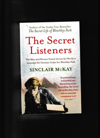
Book, Aurum Press Ltd, The secret listeners : The men and women posted across the world to intercept the secret german codes for Bletchley Park, 2012
... Service', the wartime department whose bases moved with every theatre of war (Cairo, Malta, Gibraltar, Iraq, Cyprus) as well as having listening stations along the eastern coast of Britain to intercept radio traffic in the European theatre. This is the story of the - usually very young - men and women sent out to farflung outposts to listen in for Bletchley Park, an oral history of exotic locations and ordinary lives turned upside down by a sudden remote posting - the heady nightlife in Cairo, filing cabinets full of snakes in North Africa, and flights out to Delhi by luxurious flying boat. ...Before Bletchley Park could break the German war machine's code, its daily military communications had to be monitored and recorded by 'the Listening Service', the wartime department whose bases moved with every theatre of war (Cairo, Malta, Gibraltar, Iraq, Cyprus) as well as having listening stations along the eastern coast of Britain to intercept radio traffic in the European theatre. This is the story of the - usually very young - men and women sent out to farflung outposts to listen in for Bletchley Park, an oral history of exotic locations and ordinary lives turned upside down by a sudden remote posting - the heady nightlife in Cairo, filing cabinets full of snakes in North Africa, and flights out to Delhi by luxurious flying boat.Index, ill, map, p.354.non-fictionBefore Bletchley Park could break the German war machine's code, its daily military communications had to be monitored and recorded by 'the Listening Service', the wartime department whose bases moved with every theatre of war (Cairo, Malta, Gibraltar, Iraq, Cyprus) as well as having listening stations along the eastern coast of Britain to intercept radio traffic in the European theatre. This is the story of the - usually very young - men and women sent out to farflung outposts to listen in for Bletchley Park, an oral history of exotic locations and ordinary lives turned upside down by a sudden remote posting - the heady nightlife in Cairo, filing cabinets full of snakes in North Africa, and flights out to Delhi by luxurious flying boat.world war 1939-1945 - great britain - intelligence, world war 1939-1945 - cryptography -
 Ballarat Tramway Museum
Slide - 35mm slide/s - set of 32, Noel Simons, 25/02/1971 12:00:00 AM
... park at Lake Weeroona. 1201.8 - No. 7 entering McCrae St from Nolan St. - distant view. Note "TRAM "sign on left hand side under tree and overhead in McCrae St. from former track that once was in this street. 1201.9 - No. 7 in High St. with Cathedral in background. Tram en route to North Bendigo. Note scaffolding around Cathedral main spire area. 1201.10 - No. 7 crossing Bendigo Creek bridge in High St. near Golden Square. Has a Caltex Service station...park at Lake Weeroona. 1201.8 - No. 7 entering McCrae St from Nolan St. - distant view. Note "TRAM "sign on left hand side under tree and overhead in McCrae St. from former track that once was in this street. 1201.9 - No. 7 in High St. with Cathedral in background. Tram en route to North Bendigo. Note scaffolding around Cathedral main spire area. 1201.10 - No. 7 crossing Bendigo Creek bridge in High St. near Golden Square. Has a Caltex Service station ...Set of 31 transparencies taken on 25/2/1972 on Kodak mounts. 1201.1 - Bendigo No. 26 in Bond St. just after leaving Long Gully en route for Quarry Hill. Has Norris Supermarket in background. Has two SEC roof ads. 1201.2 - No. 26 climbing View St. from Charing Cross en route to Eaglehawk. Has ANZ bank and AMOCO service station in background. 1201.3 - as for 1201.3, but after tram has passed photographer. Has buildings west of Mackenzie St. in photograph. 1201.4 - Tram stop and centre of the road pole with two "CARS STOP BY REQUEST" signs mounted on pole at the corner of Mackenzie St. 1201.5 - same position as for 1201.3, but with No. 5 descending the street. 1201.6 - same position as for 1201.2, but with No. 5 descending the street. Photo taken after tram has passed photographer. 1201.7 - No. 7 in Nolan St. from across the park at Lake Weeroona. 1201.8 - No. 7 entering McCrae St from Nolan St. - distant view. Note "TRAM "sign on left hand side under tree and overhead in McCrae St. from former track that once was in this street. 1201.9 - No. 7 in High St. with Cathedral in background. Tram en route to North Bendigo. Note scaffolding around Cathedral main spire area. 1201.10 - No. 7 crossing Bendigo Creek bridge in High St. near Golden Square. Has a Caltex Service station in the background. 1201.11 - No. 7 at Golden Square terminus with Sunburst Fruit Juices and a Peters Ice cream delivery vans alongside. 1201.12 - as for 1201.11 but photo taken from behind tram, with the end of the rails in the photograph. 1201.13 - No. 7 and 21 in Pall Mall at Charing Cross with No. 5 in the background. Taken some distance away from the location. 1201.14 - No. 7 at Golden Square terminus, taken a short distance from the tram terminus. Shows Milk Bar on right hand side and the hotel on the left hand side. Taken from the south side of the roadway. 1201.15 - as from 1201.14 but taken from the north side of the roadway. 1201.16 - No 5 waiting at California Gully loop. Distant photo showing surrounds 1201.17 - No. 5 en route for Quarry Hill crossing No. 26 at California Gully. 1201.18 - No. 26 at Eaglehawk terminus with Eaglehawk Town Hall and Post Office in background. 1201.19 - No. 21 arriving at Charing Cross en route to North Bendigo. Has Alexandra Fountain in the background, ANZ bank RACV building, and other buildings on the north side of Pall Mall or Nolan St. 1201.20 - No. 26 en route for Quarry Hill at Charing Cross, with crew standing by front door. Has Colonial Mutual life building, Armstrong Tyre Service (Firestone) and a sign for Cohns Drinks in the background. 1201.21 - as for 1201.20 but with No. 5 en route to Eaglehawk now in photograph. 1201.22 - No. 26 at Quarry Hill terminus. 1201.23 - No. 26 at Quarry Hill terminus, view of front portion of tram only from a gate at the Bendigo cemetery. 1201.24 - Track at the end of the Quarry Hill line showing the point blades of the former "Y" terminus and the overhead for this. 1201.25 - No. 2 at the Quarry Hill terminus, looking along the former Trackwork. 1201.26 - as for 1201.25 1201.27 - number not used. 1201.28 - Golden Square terminus from some distance from the actual terminus, showing the Warning sign "TRAM" for motorists from the south. No. 7 at the terminus. 1201.29 - No. 7 passing through the Golden Square shopping centre. Numerous cars and pedestrians. Tram en route for North Bendigo. 1201.30 - No. 7 in High St. Golden Square, en route for North Bendigo. Photo taken after tram has passed photographer. 1201.31 - No. 7 in High St. just past Wattle St. with the Cathedral in the background. Tram has two SEC roof ads good side on photo, 'Everything's fine in my all electric kitchen' and 'Electrical cooking - clean, quick, economical'. 1201.32 - No. 7 in High St. nearing Wattle St. Has Cathedral in the background. Photo taken after tram has passed photographer.Information written on in black ink and date stamped on purple ink. 1201.1 - "No. 26 in Bond St just after leaving Long Gully" 1201.2 - "No. 26 climbing View St. from Charing Cross" 1201.3 - "No. 26 ascending View St. from Charing Cross (At Mackenzie St.)" 1201.4 - "View St. & Mackenzie St." 1201.5 - "No. 5 in View St. near Mackenzie St." 1201.6 - "No. 5 in View St. nearing Charing Cross." 1201.7 - "No. 7 in Nolan St. seen from Lake Weeroona Park." 1201.8 - "No. 7 entering McRae St. from Nolan St. Note "TRAM" warning sign on left. 1201.9 - "No. 7 in High St. passing Short St." 1201.10 - "No. 7 crossing Bendigo Creek bridge in High St. near Golden Square." 1201.11 - "No. 7 at Golden Square terminus" 1201.12 - "No. 7 at Golden Square terminus" 1201.13 - "No 7, 21 and 5 at Charing Cross" 1201.14 - "No. 7 at Golden Square terminus" 1201.15 - "No. 7 at Golden Square terminus" 1201.16 - "No 5 waiting at California Gully loop." 1201.17 - "Nos. 5 and 26 crossing at California Gully loop" 1201.18 - "No. 26 at Eaglehawk terminus" 1201.19 - "No. 21 arriving at Charing Cross from Golden Square" 1201.20 - "No. 26 at Charing Cross" 1201.21 - "Nos. 5 and 26 at Charing Cross." 1201.22 - "No. 26 at Quarry Hill terminus" 1201.23 - "No. 26 at Quarry Hill terminus seen through the gates of the Bendigo Cemetery." 1201.24 - "Quarry Hill terminus showing remains for former double track layout abandoned before 1964." 1201.25 - "No. 2 at Quarry Hill terminus" 1201.26 - "No. 2 at Quarry Hill terminus" 1201.28 - "The Southern approach to Golden Square with No. 7 standing at the terminus, "TRAM" warning sign on the left. 1201.29 - "No. 7 passing through Golden Square Shopping Centre" 1201.30 - "No. 7 in High St. Golden Square" 1201.31 - "No. 7 in High St. passing Wattle St." 1201.32 - "No. 7 in High St. nearing Wattle St."tramways, trams, bendigo, bond st., view st., nolan st., high st., eaglehawk, california gully, charing cross, quarry hill, trackwork, tram 2, tram 5, tram 7, tram 21, tram 26 -
 Ballarat Tramway Museum
Photograph - Digital image Set of 10, Tony Smith, 19/09/1971 12:00:00 AM
... North, showing Special, nearing Sturt St. .4 - 42 turning into Sturt St, with the Shell Service station on the left. .5 - 42 reversing on the Lydiard St Nth crossover with the post office in the background. Tram showing Sebastopol. .6 - 39 reversing at Grenville St, tram showing Special. Has the Dickins and the Gasometer in the background. the conductor adjusting the trolley ropes. .7 - 39 running from Bridge St into Sturt St - as above. .8 - 34 and 39? parked...North, showing Special, nearing Sturt St. .4 - 42 turning into Sturt St, with the Shell Service station on the left. .5 - 42 reversing on the Lydiard St Nth crossover with the post office in the background. Tram showing Sebastopol. .6 - 39 reversing at Grenville St, tram showing Special. Has the Dickins and the Gasometer in the background. the conductor adjusting the trolley ropes. .7 - 39 running from Bridge St into Sturt St - as above. .8 - 34 and 39? parked ...Yields information about Ballarat Tramways and trams prior to the closure of the tramway system.Set of 10 digital images of Ballarat trams prior to closure, scanned from original slides by Tony Smith, 1971 prior to closure of the system. This set of slides appears to be the last day of operations - 19/9/1971 .1 - 40 in Drummond St Nth. near Macarthur St, showing Sebastopol. .2 - 35 turning from Drummond St north into Sturt St with the Southern Cross hotel in the background. Note the shoes in the overhead. .3 - 42 in Drummond St North, showing Special, nearing Sturt St. .4 - 42 turning into Sturt St, with the Shell Service station on the left. .5 - 42 reversing on the Lydiard St Nth crossover with the post office in the background. Tram showing Sebastopol. .6 - 39 reversing at Grenville St, tram showing Special. Has the Dickins and the Gasometer in the background. the conductor adjusting the trolley ropes. .7 - 39 running from Bridge St into Sturt St - as above. .8 - 34 and 39? parked in the City Loop. Has Patersons furniture, Gear Chemist and Edments stores in the background. .9 - 43 showing special at the Sturt and Lydiard St stop with 39? about to leave Lydiard St Nth. Has the post office in the background. .10 - 40 at the Lydiard St North terminus, with passengers boarding. Cemetery gates in the background.trams, tramways, drummond st nth, macarthur st, sturt st, closure, lydiard st nth, grenville st, city loop, closure, tram 40, tram 35, tram 42, tram 39, tram 34 -
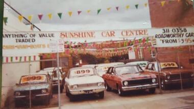 Sunshine and District Historical Society Incorporated
Photograph - McIntyre Road Sunshine North - Sunshine Car Centre C1983 Photograph
... Park 3023. Brimbank Library, 301 Hampshire Road, Sunshine 3020. melbourne This service station and the house to the left have been demolished. The site is now a car wash. McIntyre Road Sunshine North ...This service station and the house to the left have been demolished. The site is now a car wash.Sunshine Car Centremcintyre road, sunshine north -
 Sunshine and District Historical Society Incorporated
Photograph - Albion Railway Stationmaster Residence Photograph
... north of the original 1891 station building, on the corner of St. Albans Road and the station entrance reserve. It was positioned on what is now the eastern service road / station car park area, facing the tracks. ...Park 3023. Brimbank Library, 301 Hampshire Road, Sunshine 3020. melbourne The Albion Stationmaster’s Residence stood on the east side of the railway line, immediately north of the original 1891 station building, on the corner of St. Albans Road and the station entrance reserve. It was positioned on what is now the eastern service ...The Albion Stationmaster’s Residence stood on the east side of the railway line, immediately north of the original 1891 station building, on the corner of St. Albans Road and the station entrance reserve. It was positioned on what is now the eastern service road / station car park area, facing the tracks. This was the standard placement for VR residences on the Bendigo line in the late 19th century. The house was removed in the 1970's when the station car park was expanded. The removal was also during the time when the practice of the removal of redundant VR housing stock was occurring. No trace remains today.This building was used as the official home of the Stationmaster at Albion Railway Station. This was standard Victorian Railways practice from the late 1800s through the mid‑20th century. Its functions included housing the stationmaster and their family, providing 24‑hour on‑call presence for emergencies, allowing the Stationmaster to supervise the yard, signals, and level crossing and acted as a local administrative base for the station’s operations Because Albion was a junction‑adjacent station (close to the Sunshine triangle and the goods sidings), the Stationmaster’s role at this station was significant.albion railway station, railway, albion -
 Sunshine and District Historical Society Incorporated
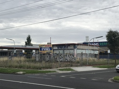
Photograph - Sunshine North Photographs 2023, John Alchin, 2023
... Park 3023. Brimbank Library, 301 Hampshire Road, Sunshine 3020. melbourne These photographs provide a visual record of assorted buildings, street views, and notable locations throughout Sunshine North in 2023. This collection of photographs preserves a visual record of Sunshine North 2023. Sunshine North Gilmour Road McIntyre Road Railway Underpass Warwick Road 5632.01 - Gilmour Rd - Barwon Ave Sunshine North - Railway Underpass 2023 Photo 01.JPG 5632.02 - McIntyre Rd 101 Sunshine North - Former Service station 2023 Photo 01.JPG 5632.03 - McIntyre Rd 113 - 119 Sunshine North - Shops 2023 Photo 01.JPG 5632.04 - McIntyre Rd 113 - 131 Sunshine North - Shops 2023 Photo 01.JPG 5632.05 - McIntyre Rd 119 - 121 Sunshine North - Shops 2023 Photo 01.JPG 5632.06 - McIntyre Rd 129 - 131 Sunshine North - Shops 2023 Photo 01.JPG 5632.07 - McIntyre Rd 129 - 131 Sunshine North - Shops 2023 Photo 02.JPG 5632.08 - McIntyre Rd 133 - 137 Sunshine North - Shops 2023 Photo 01.JPG 5632.09 - McIntyre Rd 133 - 137 Sunshine North - Shops 2023 Photo 02.JPG 5632.10 - Warwick Rd 113 Sunshine North 2023 Photo 01.JPG Collection of digital photographs Photograph Sunshine North Photographs 2023 John Alchin ...These photographs provide a visual record of assorted buildings, street views, and notable locations throughout Sunshine North in 2023.This collection of photographs preserves a visual record of Sunshine North 2023.5632.01 - Gilmour Rd - Barwon Ave Sunshine North - Railway Underpass 2023 Photo 01.JPG 5632.02 - McIntyre Rd 101 Sunshine North - Former Service station 2023 Photo 01.JPG 5632.03 - McIntyre Rd 113 - 119 Sunshine North - Shops 2023 Photo 01.JPG 5632.04 - McIntyre Rd 113 - 131 Sunshine North - Shops 2023 Photo 01.JPG 5632.05 - McIntyre Rd 119 - 121 Sunshine North - Shops 2023 Photo 01.JPG 5632.06 - McIntyre Rd 129 - 131 Sunshine North - Shops 2023 Photo 01.JPG 5632.07 - McIntyre Rd 129 - 131 Sunshine North - Shops 2023 Photo 02.JPG 5632.08 - McIntyre Rd 133 - 137 Sunshine North - Shops 2023 Photo 01.JPG 5632.09 - McIntyre Rd 133 - 137 Sunshine North - Shops 2023 Photo 02.JPG 5632.10 - Warwick Rd 113 Sunshine North 2023 Photo 01.JPG sunshine north, gilmour road, mcintyre road, railway underpass, warwick road -
 Sunshine and District Historical Society Incorporated
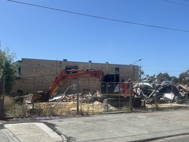
Photograph - Sunshine North Photographs 2025, John Alchin, 2025
... Park 3023. Brimbank Library, 301 Hampshire Road, Sunshine 3020. melbourne These photographs provide a visual record of assorted buildings, street views, and notable locations throughout Sunshine North in 2025. This collection of photographs preserves a visual record of Sunshine North 2025. Sunshine North Warwick Road 5638.01 - Warwick Road 86 Sunshine North - Former Service Station ...These photographs provide a visual record of assorted buildings, street views, and notable locations throughout Sunshine North in 2025.This collection of photographs preserves a visual record of Sunshine North 2025.5638.01 - Warwick Road 86 Sunshine North - Former Service Station Demolition 2025 Photo 01.JPG 5638.02 - Warwick Road 86 Sunshine North - Former Service Station Demolition 2025 Photo 02.JPG 5638.03 - Warwick Road 86 Sunshine North - Former Service Station Demolition 2025 Photo 03.JPG sunshine north, warwick road -
 Ballarat Tramway Museum
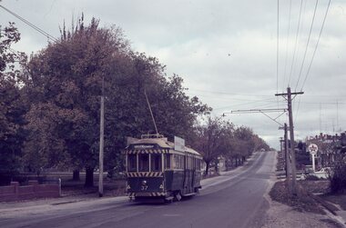
Slide - 35mm slide/s, Robert Thomson, 28/04/1965 12:00:00 AM
... North. In the background is Pearce Park and a Caltex Service Station. Dated 28.4.1965...North. In the background is Pearce Park and a Caltex Service Station. Dated 28.4.1965 Slide 35mm slide/s Robert Thomson ...Yields information about Ballarat's trams during 1965 and the Mt Pleasant line.AGFA blue / white plastic mount, colour slide of No. 37 inward bound in Barkly St Mt Pleasant, with the destination of Gardens via Drummond North. In the background is Pearce Park and a Caltex Service Station. Dated 28.4.1965"28.4.1965" in ink.tramways, trams, barkly st, mt pleasant, tram 37 -
 Puffing Billy Railway
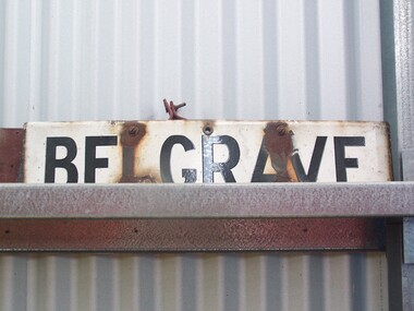
Station Sign - Belgrave
... station area re-opened on 19 February 1962 when the line as far as Belgrave was converted to broad gauge and used electric traction as part of the suburban network.[1] It has one island platform with two faces. It is serviced by Metro Trains' Belgrave line services The Puffing Billy Railway Belgrave station is located 100 metres north of the station and is accessible via a short footpath. It was required to be located further down the line than the original narrow-gauge station (which was approximately where the current suburban station car park...station area re-opened on 19 February 1962 when the line as far as Belgrave was converted to broad gauge and used electric traction as part of the suburban network.[1] It has one island platform with two faces. It is serviced by Metro Trains' Belgrave line services The Puffing Billy Railway Belgrave station is located 100 metres north of the station and is accessible via a short footpath. It was required to be located further down the line than the original narrow-gauge station (which was approximately where the current suburban station car park ...Belgrave railway station is the terminus of the electrified line from Melbourne in Victoria, Australia, serving the eastern Melbourne suburb of Belgrave. Opened as Monbulk on 18 December 1900, it was renamed Belgrave on 21 November 1904. It was upgraded to a Premium station on 2 July 1996. The station was originally on the Upper Ferntree Gully – Gembrook narrow gauge line. It, along with the rest of the line, officially closed on 30 April 1954. However it saw further use between 1955 and early 1958, when trains were operated by the Puffing Billy Preservation Society in co-operation with the Victorian Railways. The station area re-opened on 19 February 1962 when the line as far as Belgrave was converted to broad gauge and used electric traction as part of the suburban network.[1] It has one island platform with two faces. It is serviced by Metro Trains' Belgrave line services The Puffing Billy Railway Belgrave station is located 100 metres north of the station and is accessible via a short footpath. It was required to be located further down the line than the original narrow-gauge station (which was approximately where the current suburban station car park is located). ref: https://en.wikipedia.org/wiki/Belgrave_railway_station photos at http://www.vicrailstations.com/Gembrook/Belgrave/Belgrave.htmlHistoric - Victorian Railways Station sign used at Belgrave StationStation Sign - Belgrave Metal sign - white enamel back ground with black letters Belgravepuffing billy, victorian railways, belgrave station -
 Lakes Entrance Historical Society
Photograph - Foreshore Lakes Entrance, Lakes Entrance Tidy Town Committee
... Lakes Entrance Historical Society 4 Marine Parade Lakes Entrance gippsland Also a colour photograph of toilet block at North end of footbridge taken from the car park on the Eastern side 04268.1 20 x 15cm Bridges People Colour photograph taken from the forecourt at the North end of the footbridge looking towards the service station on the corner of Myers Street and Esplanade Lakes Entrance Victoria. ...Also a colour photograph of toilet block at North end of footbridge taken from the car park on the Eastern side 04268.1 20 x 15cmColour photograph taken from the forecourt at the North end of the footbridge looking towards the service station on the corner of Myers Street and Esplanade Lakes Entrance Victoria. Also a second photo showing toilet block near the footbridgebridges, people -
 Melbourne Tram Museum
Ephemera - Timetable, The Met, Set of 12 Tram Timetables, produced by The Met, 1987 - 1989
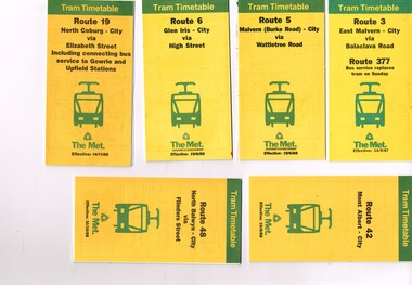
... Set of 12 Tram Timetables, produced by The Met for various routes, yellow cover with a green top band, multi fold horizontal sheet, giving a route map, description, notes, time points, information contact details and types of tickets (Neighbourhood and Travelcards) and where they could be purchased. .1 - Route 3 - East Malvern - City via Balaclava Road - replaced by bus 377 on Sundays - dated 14/9/1987 .2 - Route 5 - Malvern Burke Road - City via Wattletree Road - 19/6/1988 .3 - Route 6 - Glen Iris - City via High St - 19/6/1988 .4 - Route 19 - North Coburg - City via Elizabeth St including connecting bus service to Gowrie and Upfield stations - 14/11/1988 .5 - Route 42 - Mont Albert - City - 15/8/1988 .6 - Route 48 - North Balwyn - City via Flinders St - 31/10/1988 .7 - Route 55 - West Coburg - Domain Interchange via William St - 11/2/1987 .8 - Route 57 - West Maribyrnong - City via North Melbourne - Route 357 bus replaces tram on Sunday - 27/8/1989 .9 - Route 59 - Airport West - City via Essendon - 27/8/1989 .10 - Route 64 - East Brighton - City via Hawthorn Road - 14/9/1987 .11- Route 70 - Wattle Park (Elgar Road) Princes Bridge via Swan St - 31/10/1988 .12 - Route 86 - Bundoora - City via West Preston - 15/8/1988 Full Image of .4 added 9/4/17 following a query about route 19 timetables - see image i5....Melbourne Tram Museum 8 Wallen Road Hawthorn melbourne Trams tramways Timetables Tickets Tram Services Route 3 Route 5 Route 6 Route 19 Route 42 Route 48 Route 55 Route 57 Route 59 Route 64 Route 70 Route 86 Set of 12 Tram Timetables, produced by The Met for various routes, yellow cover with a green top band, multi fold horizontal sheet, giving a route map, description, notes, time points, information contact details and types of tickets (Neighbourhood and Travelcards) and where they could be purchased. .1 - Route 3 - East Malvern - City via Balaclava Road - replaced by bus 377 on Sundays - dated 14/9/1987 .2 - Route 5 - Malvern Burke Road - City via Wattletree Road - 19/6/1988 .3 - Route 6 - Glen Iris - City via High St - 19/6/1988 .4 - Route 19 - North Coburg - City via Elizabeth St including connecting bus service to Gowrie and Upfield stations - 14/11/1988 .5 - Route 42 - Mont Albert - City - 15/8/1988 .6 - Route 48 - North Balwyn - City via Flinders St - 31/10/1988 .7 - Route 55 - West Coburg - Domain Interchange via William St - 11/2/1987 .8 - Route 57 - West Maribyrnong - City via North Melbourne - Route 357 bus replaces tram on Sunday - 27/8/1989 .9 - Route 59 - Airport West - City via Essendon - 27/8/1989 .10 - Route 64 - East Brighton - City via Hawthorn Road - 14/9/1987 .11- Route 70 - Wattle Park (Elgar Road) Princes Bridge via Swan St - 31/10/1988 .12 - Route 86 - Bundoora - City via West Preston - 15/8/1988 Full Image of .4 added 9/4/17 following a query about route 19 timetables - see image i5. ...Set of 12 Tram Timetables, produced by The Met for various routes, yellow cover with a green top band, multi fold horizontal sheet, giving a route map, description, notes, time points, information contact details and types of tickets (Neighbourhood and Travelcards) and where they could be purchased. .1 - Route 3 - East Malvern - City via Balaclava Road - replaced by bus 377 on Sundays - dated 14/9/1987 .2 - Route 5 - Malvern Burke Road - City via Wattletree Road - 19/6/1988 .3 - Route 6 - Glen Iris - City via High St - 19/6/1988 .4 - Route 19 - North Coburg - City via Elizabeth St including connecting bus service to Gowrie and Upfield stations - 14/11/1988 .5 - Route 42 - Mont Albert - City - 15/8/1988 .6 - Route 48 - North Balwyn - City via Flinders St - 31/10/1988 .7 - Route 55 - West Coburg - Domain Interchange via William St - 11/2/1987 .8 - Route 57 - West Maribyrnong - City via North Melbourne - Route 357 bus replaces tram on Sunday - 27/8/1989 .9 - Route 59 - Airport West - City via Essendon - 27/8/1989 .10 - Route 64 - East Brighton - City via Hawthorn Road - 14/9/1987 .11- Route 70 - Wattle Park (Elgar Road) Princes Bridge via Swan St - 31/10/1988 .12 - Route 86 - Bundoora - City via West Preston - 15/8/1988 Full Image of .4 added 9/4/17 following a query about route 19 timetables - see image i5.trams, tramways, timetables, tickets, tram services, route 3, route 5, route 6, route 19, route 42, route 48, route 55, route 57, route 59, route 64, route 70, route 86 -
 Melbourne Tram Museum
Ephemera - Timetable, Melbourne & Metropolitan Tramways Board (MMTB), Set of 30 MMTB tram timetables, 1962
... Where a All night service was applicable, shown as well. .1 - Burwood - City - 9/1962 .2 - Camberwell - City - 9/1962 .3 - Carnegie - City - 6/1962 .4 - Domain Rd - City - 10/1962 .5 - East Brighton - City - 6/1962 .6 - East Coburg - city - 9/1962 .7 - East Malvern - Darling Rd - City 27/5/1962 .8 - East Preston - City - 11/1962 .9 - Essendon Aerodrome - City - July 1962 .10 - Essendon (Matthews Ave) - City - 7/1962 .11 - Glen Iris - City - 8/1962 .12 - Hawthorn - Spencer St - 7/1962 .13 - Kew Cotham Rd - St Kilda Beach - 8/1962 .14 - Malvern Burke Rd - City - 8/1962 .15 - Mont Albert - City - 7/1962 .16 - Moreland - City - 9/1962 .17 - West Coburg - City 7/1962. .18 - North Balwyn - Spencer St - 7/1962 .19 - North Coburg - City - 6/1962 - has Sunday only Fawkner Railway station service on rear - 6/1962 .20 - North Richmond - Prahran and St Kilda Beach - 7/1962 .21 - Northcote (via St Georges Rd) - City - 7/1962 .22 - Prahran - City - 7/1962 .23 - South Melbourne and St Kilda Beach - City - 6/1962 .24 - St Kilda Beach - City - - 9/1962 .25 - Toorak - City - 8/1962 .26 - Wattle Park - Elgar Rd - City - 9/1962 .27 - West Maribyrnong - City - 7/1962 .28 - West Preston - City - 6/1962 .29 - West Coburg - City - 10/1962 ,30 - East Preston - City - 7/1962...Where a All night service was applicable, shown as well. .1 - Burwood - City - 9/1962 .2 - Camberwell - City - 9/1962 .3 - Carnegie - City - 6/1962 .4 - Domain Rd - City - 10/1962 .5 - East Brighton - City - 6/1962 .6 - East Coburg - city - 9/1962 .7 - East Malvern - Darling Rd - City 27/5/1962 .8 - East Preston - City - 11/1962 .9 - Essendon Aerodrome - City - July 1962 .10 - Essendon (Matthews Ave) - City - 7/1962 .11 - Glen Iris - City - 8/1962 .12 - Hawthorn - Spencer St - 7/1962 .13 - Kew Cotham Rd - St Kilda Beach - 8/1962 .14 - Malvern Burke Rd - City - 8/1962 .15 - Mont Albert - City - 7/1962 .16 - Moreland - City - 9/1962 .17 - West Coburg - City 7/1962. .18 - North Balwyn - Spencer St - 7/1962 .19 - North Coburg - City - 6/1962 - has Sunday only Fawkner Railway station service on rear - 6/1962 .20 - North Richmond - Prahran and St Kilda Beach - 7/1962 .21 - Northcote (via St Georges Rd) - City - 7/1962 .22 - Prahran - City - 7/1962 .23 - South Melbourne and St Kilda Beach - City - 6/1962 .24 - St Kilda Beach - City - - 9/1962 .25 - Toorak - City - 8/1962 .26 - Wattle Park - Elgar Rd - City - 9/1962 .27 - West Maribyrnong - City - 7/1962 .28 - West Preston - City - 6/1962 .29 - West Coburg - City - 10/1962 ,30 - East Preston - City - 7/1962 Set of 30 MMTB tram timetables, Ephemera Timetable Melbourne & Metropolitan Tramways Board (MMTB) ...Demonstrates a set of MMTB 1962 timetables.Set of 30 MMTB tram timetables, folded sheets, 4 fold, providing timetables for specific routes, day of week giving information on tram times at the terminus, sections and fares, running times. Some signed by W. J. Richards as Acting Traffic Manager, or R. C. Drummond as Traffic Manager. Route Numbers not given on cover, generally given on inside. Where a All night service was applicable, shown as well. .1 - Burwood - City - 9/1962 .2 - Camberwell - City - 9/1962 .3 - Carnegie - City - 6/1962 .4 - Domain Rd - City - 10/1962 .5 - East Brighton - City - 6/1962 .6 - East Coburg - city - 9/1962 .7 - East Malvern - Darling Rd - City 27/5/1962 .8 - East Preston - City - 11/1962 .9 - Essendon Aerodrome - City - July 1962 .10 - Essendon (Matthews Ave) - City - 7/1962 .11 - Glen Iris - City - 8/1962 .12 - Hawthorn - Spencer St - 7/1962 .13 - Kew Cotham Rd - St Kilda Beach - 8/1962 .14 - Malvern Burke Rd - City - 8/1962 .15 - Mont Albert - City - 7/1962 .16 - Moreland - City - 9/1962 .17 - West Coburg - City 7/1962. .18 - North Balwyn - Spencer St - 7/1962 .19 - North Coburg - City - 6/1962 - has Sunday only Fawkner Railway station service on rear - 6/1962 .20 - North Richmond - Prahran and St Kilda Beach - 7/1962 .21 - Northcote (via St Georges Rd) - City - 7/1962 .22 - Prahran - City - 7/1962 .23 - South Melbourne and St Kilda Beach - City - 6/1962 .24 - St Kilda Beach - City - - 9/1962 .25 - Toorak - City - 8/1962 .26 - Wattle Park - Elgar Rd - City - 9/1962 .27 - West Maribyrnong - City - 7/1962 .28 - West Preston - City - 6/1962 .29 - West Coburg - City - 10/1962 ,30 - East Preston - City - 7/1962Some have "Robert Wilson" stamp on the covers.trams, tramways, timetables, tickets, fares, mmtb, all night services -
 Melbourne Tram Museum
Ephemera - Tram Route Guides, Public Transport Victoria (PTV), "Tram Route Guide", Feb. 2016
... Each comprises a vertical DL folded sheet, full colour for the nominated routes, with Yarra Trams and PTV logos, listing the stops, interchanges with bus and other tram services, ticketing zones, estimated frequencies with adverts for Night tram services, TramTracker and Myki tickets. .1 - Route 1 - East Coburg to South Melbourne Beach .2 - Route 5 - Melbourne University to Malvern .3 - Route 6 - Melbourne University to Glen Iris .4 - Route 8 - Moreland to Toorak .5 -Route 57 - West Maribyrnong to Flinders St Station (2 copies) .6 - Route 70 - Wattle Park to Waterfront City Docklands .7 - Route 72 - Melbourne University to Camberwell .8 - Route 75 - Vermont South to Etihad Stadium / Bourke St Docklands .9 - Route 82 - Footscray to Moonee Ponds .10 - Route 19 - North Coburg to Flinders St Station .11 - Route 55 - West Coburg to Domain Interchange (two copies held) .12 - Route 59 - Airport West to Flinders St Station .13 - Route 30 - St Vincent's Plaza to Ethida Stadium Docklands .14 - Route 12 - Victoria Gardens to St Kilda / Fitzroy St .15 - Route 64 - Melbourne University to East Brighton .16 - Route 78 - North Richmond to Balaclava (via Prahran) .17 - Route 86 - Bundoora (RMIT) to Waterfront City Docklands .18 - Route 96 - East Brunswick to St Kilda Beach .19 - Route 11 - West Preston to Victoria Harbour Docklands ,20 - Route 16 - Melbourne University to Kew via St Kilda .21 - Route 48 - North Balwyn to Victoria Harbour Docklands .22 - Route 67 - Melbourne University to Carnegie .23 - Route 109 - Box Hill to Port Melbourne See Reg Item 2396 for 2012, 2939 for 2015 and 2940 for 2014 versions Items .13 to .18 added 2/9/18...Each comprises a vertical DL folded sheet, full colour for the nominated routes, with Yarra Trams and PTV logos, listing the stops, interchanges with bus and other tram services, ticketing zones, estimated frequencies with adverts for Night tram services, TramTracker and Myki tickets. .1 - Route 1 - East Coburg to South Melbourne Beach .2 - Route 5 - Melbourne University to Malvern .3 - Route 6 - Melbourne University to Glen Iris .4 - Route 8 - Moreland to Toorak .5 -Route 57 - West Maribyrnong to Flinders St Station (2 copies) .6 - Route 70 - Wattle Park to Waterfront City Docklands .7 - Route 72 - Melbourne University to Camberwell .8 - Route 75 - Vermont South to Etihad Stadium / Bourke St Docklands .9 - Route 82 - Footscray to Moonee Ponds .10 - Route 19 - North Coburg to Flinders St Station .11 - Route 55 - West Coburg to Domain Interchange (two copies held) .12 - Route 59 - Airport West to Flinders St Station .13 - Route 30 - St Vincent's Plaza to Ethida Stadium Docklands .14 - Route 12 - Victoria Gardens to St Kilda / Fitzroy St .15 - Route 64 - Melbourne University to East Brighton .16 - Route 78 - North Richmond to Balaclava (via Prahran) .17 - Route 86 - Bundoora (RMIT) to Waterfront City Docklands .18 - Route 96 - East Brunswick to St Kilda Beach .19 - Route 11 - West Preston to Victoria Harbour Docklands ,20 - Route 16 - Melbourne University to Kew via St Kilda .21 - Route 48 - North Balwyn to Victoria Harbour Docklands .22 - Route 67 - Melbourne University to Carnegie .23 - Route 109 - Box Hill to Port Melbourne See Reg Item 2396 for 2012, 2939 for 2015 and 2940 for 2014 versions Items .13 to .18 added 2/9/18 "Tram Route Guide" Ephemera Tram Route Guides Public Transport Victoria (PTV) ...Set of 18 Tram Route Guides, published during 2016. Each comprises a vertical DL folded sheet, full colour for the nominated routes, with Yarra Trams and PTV logos, listing the stops, interchanges with bus and other tram services, ticketing zones, estimated frequencies with adverts for Night tram services, TramTracker and Myki tickets. .1 - Route 1 - East Coburg to South Melbourne Beach .2 - Route 5 - Melbourne University to Malvern .3 - Route 6 - Melbourne University to Glen Iris .4 - Route 8 - Moreland to Toorak .5 -Route 57 - West Maribyrnong to Flinders St Station (2 copies) .6 - Route 70 - Wattle Park to Waterfront City Docklands .7 - Route 72 - Melbourne University to Camberwell .8 - Route 75 - Vermont South to Etihad Stadium / Bourke St Docklands .9 - Route 82 - Footscray to Moonee Ponds .10 - Route 19 - North Coburg to Flinders St Station .11 - Route 55 - West Coburg to Domain Interchange (two copies held) .12 - Route 59 - Airport West to Flinders St Station .13 - Route 30 - St Vincent's Plaza to Ethida Stadium Docklands .14 - Route 12 - Victoria Gardens to St Kilda / Fitzroy St .15 - Route 64 - Melbourne University to East Brighton .16 - Route 78 - North Richmond to Balaclava (via Prahran) .17 - Route 86 - Bundoora (RMIT) to Waterfront City Docklands .18 - Route 96 - East Brunswick to St Kilda Beach .19 - Route 11 - West Preston to Victoria Harbour Docklands ,20 - Route 16 - Melbourne University to Kew via St Kilda .21 - Route 48 - North Balwyn to Victoria Harbour Docklands .22 - Route 67 - Melbourne University to Carnegie .23 - Route 109 - Box Hill to Port Melbourne See Reg Item 2396 for 2012, 2939 for 2015 and 2940 for 2014 versions Items .13 to .18 added 2/9/18Item 11 has the "5" changed to "8" in Texta - see history of object.trams, tramways, timetables, maps, route 1, route 5, route 6, route 8, route 11, route 16, route 132, route 19, route 30, route 48, route 55, route 57, route 59, route 64, route 67, route 70, route 72, route 75, route 78, route 82, route 86, route 96, route 109, east coburg, west coburg, airport west, north coburg, south melbourne, malvern, glen iris, moreland, toorak, west maribyrnong, wattle park, docklands, camberwell, vermont south, footscray, moonee ponds, st vincent's plaza, victoria gardens, east brighton, north richmond, balaclava, bundoora, east brunswick, west preston, kew, north balwyn, carnegie, box hill -
 Melbourne Tram Museum
Slide, Keith Caldwell, 12/03/1960 12:00:00 AM
... North Essendon, crossing the street access for Marco Polo Street. The tram showing route 59, Essendon Aerodrome, has trolley wheels and has a second person in the cab, possibly a trainer. Unusually the tram number is placed above the headlight, In the background are the palm trees in the centre median plantation. The house with the red guttering is one that dates back to the gold mining era. See http://www.esshissoc.org.au/1070%20Mount%20Alexander%20Road.pdf It was relocated to Woodland Park during 2017? Note the Centre poles, overhead construction and street light. Also in the background is a Mobil Service station...North Essendon, crossing the street access for Marco Polo Street. The tram showing route 59, Essendon Aerodrome, has trolley wheels and has a second person in the cab, possibly a trainer. Unusually the tram number is placed above the headlight, In the background are the palm trees in the centre median plantation. The house with the red guttering is one that dates back to the gold mining era. See http://www.esshissoc.org.au/1070%20Mount%20Alexander%20Road.pdf It was relocated to Woodland Park during 2017? Note the Centre poles, overhead construction and street light. Also in the background is a Mobil Service station ...Agfa Colour slide, cardboard mount, by Keith Caldwell dated 12 March 1960, of W5 818 running in Mount Alexander Road, North Essendon, crossing the street access for Marco Polo Street. The tram showing route 59, Essendon Aerodrome, has trolley wheels and has a second person in the cab, possibly a trainer. Unusually the tram number is placed above the headlight, In the background are the palm trees in the centre median plantation. The house with the red guttering is one that dates back to the gold mining era. See http://www.esshissoc.org.au/1070%20Mount%20Alexander%20Road.pdf It was relocated to Woodland Park during 2017? Note the Centre poles, overhead construction and street light. Also in the background is a Mobil Service station that later became a garden centre. Now a block of apartments.hand stamped "12 Mar '60"trams, tramways, mount alexander rd, north essendon, essendon airport, essendon aerodrome, route 59, w5 class, tram 818 -
 Melbourne Tram Museum
Ephemera - Tram Route Guides, Public Transport Victoria (PTV), "Tram Route Map", 11/2014 to 6/2015
... Each comprises a vertical DL folded sheet, full colour for the nominated routes, with Yarra Trams and PTV logos, listing the stops, interchanges with bus and other tram services, ticketing zones, estimated frequencies with adverts for Night tram services, TramTracker and Myki tickets. 1 - Route 5 - Melbourne University to Malvern 2 - Route 6 - Melbourne University to Glen Iris 3 - Route 8 - Moreland to Toorak 4 - Route 11 - West Preston - Victoria Harbour Docklands 5 - Route 19 - North Coburg - Flinders St Station 6 - Route 70 - Wattle Park to Waterfront City Docklands 7 - Route 72 - Melbourne University to Camberwell 8 - Route 1 - East Coburg - South Melbourne Beach 9 - Route 3 and 3A - Melbourne University to East Malvern 10 - Route 16 - Melbourne University to Kew 11 - Route 55 - West Coburg - Domain Interchange 12 - Route 57 - West Maribyrnong - Flinders St Station 13 - Route 59 - Airport West - Flinders St. ...Melbourne Tram Museum 8 Wallen Road Hawthorn melbourne Each comprises a vertical DL folded sheet, full colour for the nominated routes, with Yarra Trams and PTV logos, listing the stops, interchanges with bus and other tram services, ticketing zones, estimated frequencies with adverts for Night tram services, TramTracker and Myki tickets. 1 - Route 5 - Melbourne University to Malvern 2 - Route 6 - Melbourne University to Glen Iris 3 - Route 8 - Moreland to Toorak 4 - Route 11 - West Preston - Victoria Harbour Docklands 5 - Route 19 - North Coburg - Flinders St Station 6 - Route 70 - Wattle Park to Waterfront City Docklands 7 - Route 72 - Melbourne University to Camberwell 8 - Route 1 - East Coburg - South Melbourne Beach 9 - Route 3 and 3A - Melbourne University to East Malvern 10 - Route 16 - Melbourne University to Kew 11 - Route 55 - West Coburg - Domain Interchange 12 - Route 57 - West Maribyrnong - Flinders St Station 13 - Route 59 - Airport West - Flinders St. ...Each comprises a vertical DL folded sheet, full colour for the nominated routes, with Yarra Trams and PTV logos, listing the stops, interchanges with bus and other tram services, ticketing zones, estimated frequencies with adverts for Night tram services, TramTracker and Myki tickets. 1 - Route 5 - Melbourne University to Malvern 2 - Route 6 - Melbourne University to Glen Iris 3 - Route 8 - Moreland to Toorak 4 - Route 11 - West Preston - Victoria Harbour Docklands 5 - Route 19 - North Coburg - Flinders St Station 6 - Route 70 - Wattle Park to Waterfront City Docklands 7 - Route 72 - Melbourne University to Camberwell 8 - Route 1 - East Coburg - South Melbourne Beach 9 - Route 3 and 3A - Melbourne University to East Malvern 10 - Route 16 - Melbourne University to Kew 11 - Route 55 - West Coburg - Domain Interchange 12 - Route 57 - West Maribyrnong - Flinders St Station 13 - Route 59 - Airport West - Flinders St. Station 14 - Route 64 - Melbourne University - East Brighton 15 - Route 67 - Melbourne University - Carnegie 16 - Route 78 - North Richmond - Balaclava via Prahran 17 - Route 82 - Footscray - Moonee Ponds 18 - Route 48 - Victoria Harbour to North Balwyn 19 - Route 109 - Box Hill - Port Melbourne See Reg Item 2396 for 2012, 2278 for 2016 and 2940 for 2014 versionsDemonstrates PTV work in providing printed route mapsSet of 19 Tram Route Maps, published during 2014 and 2015. trams, tramways, timetables, maps, route 1, route 3, route 5, route 6, route 8, route 11, route 16, route 19, route 55, route 57, route 59, route 64, route 67, route 70, route 72, route 78, route 82, east coburg, south melbourne, east malvern, kew, west coburg, west maribyrnong, airport west, east brighton, carnegie, north richmond, balaclava, footscray, moonee ponds, malvern, glen iris, moreland, west preston, north coburg, wattle park, camberwell, route 48, north balwynp, box hill -
 Ballarat Tramway Museum
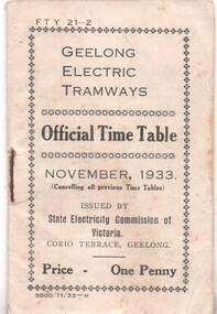
Ephemera - Timetable, State Electricity Commission of Victoria (SECV), "Geelong Electric Tramways - Official Time Table", 11/1933
... station, West Geelong to Wharf or rail, East Geelong from Moorabool and Ryrie Sts, Chilwell to Moorabool & Ryrie Sts, Eastern Park, Belmont and North. Centre page and rear pages have adverts for SEC appliances, radios. Schedules given for weekdays, extras on Friday, Saturdays and Sundays. Rear page has a schedule of Fares, passenger luggage or Parcels. Issued by the SECV Nov. 1933. On the bottom left-hand side of the front page is the print order details "5,000 11/33-H" and "FTY 21-2" in the top left hand corner. Yields information about Geelong tram services ...Timetable detailing the times of each tram on the Newtown to Wharf or Railway station, West Geelong to Wharf or rail, East Geelong from Moorabool and Ryrie Sts, Chilwell to Moorabool & Ryrie Sts, Eastern Park, Belmont and North. Centre page and rear pages have adverts for SEC appliances, radios. Schedules given for weekdays, extras on Friday, Saturdays and Sundays. Rear page has a schedule of Fares, passenger luggage or Parcels. Issued by the SECV Nov. 1933. On the bottom left-hand side of the front page is the print order details "5,000 11/33-H" and "FTY 21-2" in the top left hand corner.Yields information about Geelong tram services in 1933, after the construction of further lines, eg North, Belmont and Eastern Park.Printed, single stapled 8 sheets folded and titled "Geelong Electric Tramways - Official Time Table", dated November 1933, 32 pages.geelong, timetables, secv -
 Ballarat Tramway Museum
Photograph - Black & White Photograph/s, Harvey Studios, 18/02/1953 12:00:00 AM
... Service) A.M.P. Chambers Lydiard St. N Ballarat" On rear of .1 is the N.L.Harvey stamp and Wal's notes "SEC Ballarat Geelong Wharfies Specials, Lydiard St Nth at 11.5am, 18-2-53, Nos. 15, 35, 39, 38, 34, 37, 40" Black and white photograph of seven bogie trams lined up with passengers boarding in Lydiard St. North, between Mair St and the Railway Station for the Geelong Waterside Workers picnic day on Wednesday 18/2/1953. Closest tram is No. 40. Photo taken from the Railway Station car park ...Yields information about the tram arrangements for a large group from Geelong and the Geelong wharfies made for their picnic - probably at the Gardens. Demonstrates transport arrangements in the 1950's.Black and white photograph of seven bogie trams lined up with passengers boarding in Lydiard St. North, between Mair St and the Railway Station for the Geelong Waterside Workers picnic day on Wednesday 18/2/1953. Closest tram is No. 40. Photo taken from the Railway Station car park entrance. Provincial Hotel and other buildings on west side of Lydiard St. in photo. Published in the Courier 19/2/1953 - advised by Alan Bradley - 15/3/2003. 1880.1 - Digital image of the same photo from the Wal Jack Album. See images i2 and i3 for details, i3 for the rear of the photograph. Wal Jack notes identifies the trams as Nos. 15, 35, 39, 38, 34, 37, 40"On rear in blue ink "10 - Special trams chartered to convey Geelong Waterside Workers Picnic participants from Railway Station to Lake Wendouree Botanical Gardens o Wednesday 18 Feby '53". Under writing is word "Ballarat" in pencil. In top right hand corner, in a purple ink hand stamp is "N.L. Harvey (Photo Press Service) A.M.P. Chambers Lydiard St. N Ballarat" On rear of .1 is the N.L.Harvey stamp and Wal's notes "SEC Ballarat Geelong Wharfies Specials, Lydiard St Nth at 11.5am, 18-2-53, Nos. 15, 35, 39, 38, 34, 37, 40"trams, tramways, picnics, lydiard st. nth, geelong waterside workers, charters, tram hire, tram 40 -
 Melbourne Tram Museum
Ephemera - Timetable - Met Bus - set of 5, The Met, 1996/97
... Set of 5 Met Bus timetables - all with a route map on the rear. 1 - Routes 216 and 219, Deer Park West - City - Brighton Beach/Gardenvale - dated 27/10/1996 2 - route 220 - Sunshine - Gardenvale - dated 14/4/1996 3 - Routes 223 and 215 - Yarraville Station to Highpoint and Deer Park West to Highpoint - dated Dec. 1996 4 - Route 232 - Altona North - Victoria Market via West Gate Freeway and Crown Casino - dated 14/4/1996 - this service effectively combined the two railway tram routes. 5 - Route 600 - St Kilda to Southland via Elwood, Brighton, Sandringham, Black Rock and Cheltenham - dated March 1997...Melbourne Tram Museum 8 Wallen Road Hawthorn melbourne Set of 5 Met Bus timetables - all with a route map on the rear. 1 - Routes 216 and 219, Deer Park West - City - Brighton Beach/Gardenvale - dated 27/10/1996 2 - route 220 - Sunshine - Gardenvale - dated 14/4/1996 3 - Routes 223 and 215 - Yarraville Station to Highpoint and Deer Park West to Highpoint - dated Dec. 1996 4 - Route 232 - Altona North - Victoria Market via West Gate Freeway and Crown Casino - dated 14/4/1996 - this service effectively combined the two railway tram routes. 5 - Route 600 - St Kilda to Southland via Elwood, Brighton, Sandringham, Black Rock and Cheltenham - dated March 1997 Yields information about some of the Met Bus services in 1996 and 1997. maps bus services route 216 route 219 route 220 route 223 route 215 route 232 route 600 Met Bus Set of five Met Bus timetables, DL size, printed in two colours. ...Set of 5 Met Bus timetables - all with a route map on the rear. 1 - Routes 216 and 219, Deer Park West - City - Brighton Beach/Gardenvale - dated 27/10/1996 2 - route 220 - Sunshine - Gardenvale - dated 14/4/1996 3 - Routes 223 and 215 - Yarraville Station to Highpoint and Deer Park West to Highpoint - dated Dec. 1996 4 - Route 232 - Altona North - Victoria Market via West Gate Freeway and Crown Casino - dated 14/4/1996 - this service effectively combined the two railway tram routes. 5 - Route 600 - St Kilda to Southland via Elwood, Brighton, Sandringham, Black Rock and Cheltenham - dated March 1997Yields information about some of the Met Bus services in 1996 and 1997.Set of five Met Bus timetables, DL size, printed in two colours.maps, bus services, route 216, route 219, route 220, route 223, route 215, route 232, route 600, met bus -
 Melbourne Tram Museum
Slide - MMTB, and TMSV Tours - set of 12, Hugh Ballment, 1960s to 1980s
... HBM243 - MMTB Tram 610, 22/09/1968, Brunswick depot, HBM244 - MMTB Trams 676, 180, 10/09/1967, River St, HBM245 - MMTB Tram 676, 10/09/1967, Dandenong Rd - Caulfield loop. , Has the Hoys theatre in the background HBM246 - MMTB Tram 676, 10/09/1967, Union Rd Ascot Vale, with the Showgrounds in the far background and a building with adverts for Four'n Twenty Pies HBM247 - MMTB, 28/07/1968, Preston workshops, Short traverser HBM248 - MMTB Trams 928 180, 10/09/1967, Holmes St, At Moreland Rd - derailed with TMSV tour trams in the background and now a lot of onlookers' HBM249 - MMTB Tram 928, 10/09/1967, Holmes St, At Moreland Rd - derailed HBM250 - MMTB Trams 7, 6, 10/09/1967, South Melbourne depot, Per way yard HBM251 - MMTB Tram 610, 22/09/1968, Victoria St, Looking east from Elizabeth St, with CUB buildings and an Ampol service station HBM252 - MMTB Trams 676, 180, 10/09/1967, Elizabeth St, At terminus with Flinders St station in the background with an advert for Sitmar line, Hosies Hotel and Damman's sandwich shop HBM253 - MTA Tram 2067, c1988, Albert Park, Light rail level crossing, showing only traffic lights. Yields information about Melbourne tram operations, TMSV tours of the 1960s, and photos of Melbourne tramways. Tramways tram 610 TMSV tram 104 The Zoo tram 676 tram 106 Brunswick Depot Preston Workshops Traverser victoria parade North ...Set of 12 photos by Hugh Ballment, unless noted, of MMTB trams and TMSV Tours. HBM242 - MMTB Trams 676, 180, 10/09/1967, North Coburg, At terminus. Has a chemist shop in the background that did night prescriptions. HBM243 - MMTB Tram 610, 22/09/1968, Brunswick depot, HBM244 - MMTB Trams 676, 180, 10/09/1967, River St, HBM245 - MMTB Tram 676, 10/09/1967, Dandenong Rd - Caulfield loop. , Has the Hoys theatre in the background HBM246 - MMTB Tram 676, 10/09/1967, Union Rd Ascot Vale, with the Showgrounds in the far background and a building with adverts for Four'n Twenty Pies HBM247 - MMTB, 28/07/1968, Preston workshops, Short traverser HBM248 - MMTB Trams 928 180, 10/09/1967, Holmes St, At Moreland Rd - derailed with TMSV tour trams in the background and now a lot of onlookers' HBM249 - MMTB Tram 928, 10/09/1967, Holmes St, At Moreland Rd - derailed HBM250 - MMTB Trams 7, 6, 10/09/1967, South Melbourne depot, Per way yard HBM251 - MMTB Tram 610, 22/09/1968, Victoria St, Looking east from Elizabeth St, with CUB buildings and an Ampol service station HBM252 - MMTB Trams 676, 180, 10/09/1967, Elizabeth St, At terminus with Flinders St station in the background with an advert for Sitmar line, Hosies Hotel and Damman's sandwich shop HBM253 - MTA Tram 2067, c1988, Albert Park, Light rail level crossing, showing only traffic lights. Yields information about Melbourne tram operations, TMSV tours of the 1960s, and photos of Melbourne tramways.Kodachrome cardboard and plastic mounts, with notes - set of 12tramways, tram 610, tmsv, tram 104, the zoo, tram 676, tram 106, brunswick depot, preston workshops, traverser, victoria parade, north coburg, caulfield, dandenon road, union road, derailment, tram 6, tram 7, south melbourne depot, tram 2067, albert park, level crossing, elizabeth st, victoria st, tram 928 -
 Sunshine and District Historical Society Incorporated
Archive - City of Sunshine Health Act Registration Schedule 1977, City of Sunshine, 1977
... Westbound 439 Ballarat Road Sunshine Eating House 459 Ballarat Road Sunshine Milk Bar / Mixed Business 469 Ballarat Road Sunshine Fish Shop 471 Ballarat Road Sunshine Mixed Business Food 473 Ballarat Road Sunshine Wholesale Egg Store 479 Ballarat Road Sunshine Vending Machine Sunshine Cabinet Works 503 Ballarat Road Sunshine Apartment House Caravan Park 610 Ballarat Road Sunshine Take Away Food Kentucky Fried Chicken 429A Ballarat Road Sunshine Vending Machine Mobil Service Station 432 Ballarat Road Sunshine North Vending Machine Spaldings 480 Ballarat Road Sunshine North Vending Machine Ajax Nettlefolds 484 Ballarat Road Sunshine North Eating House Ajax Nettlefolds 484 Ballarat Road Sunshine North Vending Machine National Food Service Nettlefolds 484 Ballarat Road Sunshine North Vending Machine Nettlefolds 484 Ballarat Road Sunshine North Eating House McDonalds 400 - 402 Ballarat Road Sunshine North Motor Wrecking Ballarat Road Cnr Carrington Drive Albion Mixed Business Ballarat Road Cnr Churchill Avenue Maidstone Eating House Ballarat Road Cnr Holt Street Ardeer Mixed Business 23 Beachley Street Braybrook Milk Bar 31 Beachley Street Braybrook Fish Shop 33 Beachley Street Braybrook Fish & Chips 3 Bell Street Sunshine West Greengrocer 1A Bell Street Sunshine West Butchers 1D Bell Street Sunshine West Milk Bar 61 Berkshire Road Sunshine North Vending Machine Rockwell Axles Berkshire Road Sunshine North Bulk Tallow Plant Burke Road Braybrook Soap Manufacturing Pennell 43 - 45 Burke Street Braybrook Vending Machine G.U.D. ...Westbound 439 Ballarat Road Sunshine Eating House 459 Ballarat Road Sunshine Milk Bar / Mixed Business 469 Ballarat Road Sunshine Fish Shop 471 Ballarat Road Sunshine Mixed Business Food 473 Ballarat Road Sunshine Wholesale Egg Store 479 Ballarat Road Sunshine Vending Machine Sunshine Cabinet Works 503 Ballarat Road Sunshine Apartment House Caravan Park 610 Ballarat Road Sunshine Take Away Food Kentucky Fried Chicken 429A Ballarat Road Sunshine Vending Machine Mobil Service Station 432 Ballarat Road Sunshine North Vending Machine Spaldings 480 Ballarat Road Sunshine North Vending Machine Ajax Nettlefolds 484 Ballarat Road Sunshine North Eating House Ajax Nettlefolds 484 Ballarat Road Sunshine North Vending Machine National Food Service Nettlefolds 484 Ballarat Road Sunshine North Vending Machine Nettlefolds 484 Ballarat Road Sunshine North Eating House McDonalds 400 - 402 Ballarat Road Sunshine North Motor Wrecking Ballarat Road Cnr Carrington Drive Albion Mixed Business Ballarat Road Cnr Churchill Avenue Maidstone Eating House Ballarat Road Cnr Holt Street Ardeer Mixed Business 23 Beachley Street Braybrook Milk Bar 31 Beachley Street Braybrook Fish Shop 33 Beachley Street Braybrook Fish & Chips 3 Bell Street Sunshine West Greengrocer 1A Bell Street Sunshine West Butchers 1D Bell Street Sunshine West Milk Bar 61 Berkshire Road Sunshine North Vending Machine Rockwell Axles Berkshire Road Sunshine North Bulk Tallow Plant Burke Road Braybrook Soap Manufacturing Pennell 43 - 45 Burke Street Braybrook Vending Machine G.U.D. ...The City of Sunshine Health Inspector had a broad mandate to protect public health across the municipality. Their duties included inspecting food premises such as: - Restaurants - Cafés - Takeaway shops - Milk bars - Supermarkets - Food vans - Market stalls They checked for: - Safe food handling practices - Correct storage temperatures (hot and cold holding) - Cleanliness of food preparation areas - Pest control and vermin prevention - Staff hygiene and hand‑washing facilities - Proper waste and grease‑trap management These inspections were carried out under the Food Act and local by‑laws. This list of businesses in the City of Sunshine is an extract from a report by the City of Sunshine Health Inspector in 1977.This report records the business name, type of business and address of businesses operating in the City of Sunshine in 1977.Milk Bar 62 Adelaide Street Albion Fruiterer 26 Amelia Avenue Deer Park Milk Bar 133 Anderson Road Albion Milk Bar / Mixed Business 11 Ardoyne Street Sunshine Milk Bar / Mixed Business 11 Ardoyne Street Sunshine Vending Machine National Springs 185 - 195 Ashley Street Braybrook Vending Machine Harland Engineering Ashley Street Braybrook Hairdressers 511 Ballarat Road Albion Fish & Chips 513 Ballarat Road Albion Food Premises 580 Ballarat Road Albion Motor Wrecking 584 Ballarat Road Albion Licensed Grocer 501 - 507 Ballarat Road Albion Vending Machine Swingbridge Motors Ballarat Road Albion Eating House Highway Inn Motel 608 Ballarat Road Ardeer Milk Bar / Kiosk Apollo Gardens 610 Ballarat Road Ardeer Camping Area Caravan Park 610 Ballarat Road Ardeer Vending Machine McEwans 614 Ballarat Road Ardeer Snack Foods Manufacturer 254 Ballarat Road Braybrook Vending Machine Dyecraft 265 Ballarat Road Braybrook Milk Bar 282 Ballarat Road Braybrook Hairdresser 284 Ballarat Road Braybrook Food Premises 290 Ballarat Road Braybrook Retail Butcher 292 Ballarat Road Braybrook Vending Machine D. Richardson & Sons 330 Ballarat Road Braybrook Eating House D. Richardson & Sons 330 Ballarat Road Braybrook Vending Machine D. Richardson & Sons 330 Ballarat Road Braybrook Fish Shop 306A Ballarat Road Braybrook Milk Bar 306A Ballarat Road Braybrook Vending Machine 463 Ballarat Road Deer Park Eating House ICI Recreation Club 770 Ballarat Road Deer Park Retail Butcher Star Butchers 807 Ballarat Road Deer Park Licensed Grocery 809 Ballarat Road Deer Park Milk Bar / Mixed Business 813 Ballarat Road Deer Park Milk Bar / Mixed Business 815 Ballarat Road Deer Park Fruiterer 817 Ballarat Road Deer Park Milk Bar & Delicatessen 825 Ballarat Road Deer Park Milk Bar 825 Ballarat Road Deer Park Milk Bar 825 Ballarat Road Deer Park Fish & Chips 801A Ballarat Road Deer Park Fish & Chip Shop 801A Ballarat Road Deer Park Eating House 801B Ballarat Road Deer Park Fruit Shop 807A Ballarat Road Deer Park Vending Machine Goldern Fleece Service Station Ballarat Road Deer Park Hairdressers 5 Ballarat Road Maidstone Mixed Business 83 Ballarat Road Maidstone Butcher's Shop 151 Ballarat Road Maidstone Mixed Business 154 Ballarat Road Maidstone Mixed Business 193 Ballarat Road Maidstone Grocery Retail 129 - 131 Ballarat Road Maidstone Milk Bar 49A Ballarat Road Maidstone Food Premises 361 Ballarat Road Sunshine Mens Hairdresser Shop 363 Ballarat Road Sunshine Vending Machine B.P. Westbound 439 Ballarat Road Sunshine Eating House 459 Ballarat Road Sunshine Milk Bar / Mixed Business 469 Ballarat Road Sunshine Fish Shop 471 Ballarat Road Sunshine Mixed Business Food 473 Ballarat Road Sunshine Wholesale Egg Store 479 Ballarat Road Sunshine Vending Machine Sunshine Cabinet Works 503 Ballarat Road Sunshine Apartment House Caravan Park 610 Ballarat Road Sunshine Take Away Food Kentucky Fried Chicken 429A Ballarat Road Sunshine Vending Machine Mobil Service Station 432 Ballarat Road Sunshine North Vending Machine Spaldings 480 Ballarat Road Sunshine North Vending Machine Ajax Nettlefolds 484 Ballarat Road Sunshine North Eating House Ajax Nettlefolds 484 Ballarat Road Sunshine North Vending Machine National Food Service Nettlefolds 484 Ballarat Road Sunshine North Vending Machine Nettlefolds 484 Ballarat Road Sunshine North Eating House McDonalds 400 - 402 Ballarat Road Sunshine North Motor Wrecking Ballarat Road Cnr Carrington Drive Albion Mixed Business Ballarat Road Cnr Churchill Avenue Maidstone Eating House Ballarat Road Cnr Holt Street Ardeer Mixed Business 23 Beachley Street Braybrook Milk Bar 31 Beachley Street Braybrook Fish Shop 33 Beachley Street Braybrook Fish & Chips 3 Bell Street Sunshine West Greengrocer 1A Bell Street Sunshine West Butchers 1D Bell Street Sunshine West Milk Bar 61 Berkshire Road Sunshine North Vending Machine Rockwell Axles Berkshire Road Sunshine North Bulk Tallow Plant Burke Road Braybrook Soap Manufacturing Pennell 43 - 45 Burke Street Braybrook Vending Machine G.U.D. Burton Crescent Maribyrnong Motor Wrecking 18 Carrington Drive Albion Butcher 162 Churchill Avenue Braybrook Bakery & Shop 166 Churchill Avenue Braybrook Ladies Hairdressers 174 Churchill Avenue Braybrook Fish & Chip Shop 176 Churchill Avenue Braybrook Licenced Grocery 158 - 160 Churchill Avenue Braybrook Milk Bar / Mix Business 170 - 172 Churchill Avenue Braybrook Fishmonger 8 City Place Sunshine Butcher's Shop S.S. Meats 11 City Place Sunshine Retail Fish Sunshine Market 13 City Place Sunshine Retail Health Foods Sunshine Market 13 City Place Sunshine Retail Fruit / Eggs Stalls 3, 10 & 11 Sunshine Market 15 City Place Sunshine Delicatessen Sunshine Market 17 City Place Sunshine Supermarket Safeway 7 Clarke Street Sunshine Vending Machine Safeway 7 Clarke Street Sunshine Butcher 8 Clarke Street Sunshine Butcher Storeroom / Factory 11 Clarke Street Sunshine Hairdresser Room 7 2A Clarke Street Sunshine Milk Bar 1 Commercial Street Maidstone Hairdressers 7 Commercial Street Maidstone Chiropodist Corio Street Sunshine Chiropodist 39 Cornwall Road Sunshine North Gut Cleaning 37 Cranwell Street Braybrook Fat Extracting 37 Cranwell Street Braybrook Boiling Down 37 Cranwell Street Braybrook Piggery 37 Cranwell Street Braybrook Storage Canned Food 37 Cranwell Street Braybrook Packaging Food Products Cranwell Street Cnr Errol Street Braybrook Food Packing Southern Packages Cranwell Street Cnr Errol Street Braybrook Milk Bar / Mixed Business 24 Cypress Avenue Brooklyn Milk Bar 24 Cypress Avenue Brooklyn Vending Machine Steelcraft Baby Carriages 99 Derby Road Sunshine Ladies Hairdressers 110 Derby Road Sunshine Vending Machine Raleigh Nursery Derby Road Cnr Thorpe Street Sunshine Eating House Raleigh Nursery Derby Road Cnr Thorpe Street Sunshine Vending Machine Massey Ferguson 2 Devonshire Road Sunshine Vending Machine Sunshine Post Office 5 Devonshire Road Sunshine Milk Bar / Mixed Business 100 Devonshire Road Sunshine Vending Machine Massey Ferguson Devonshire Road Sunshine Milk Bar 5 Dickson Street Sunshine Fruit Shop 15 Dickson Street Sunshine Food Premises 27 Disraeli Street St. Albans Hairdressers 69 Dumfries Street Deer Park Fish Shop 71 Dumfries Street Deer Park Milk Bar 73 Dumfries Street Deer Park Butcher 75 Dumfries Street Deer Park Coffee 113 Durham Road Sunshine Hairdresser Shop 1 117 Durham Road Sunshine Drinks Lot 1 Emu Road Maidstone Vending Machine Pridhams Sociel Club 11 Evans Street Braybrook Processing & Pack Dripping Pridhams 21 Evans Street Braybrook Gut Cleaning Pridhams 21 Evans Street Braybrook Rendering Works Pridhams 21 Evans Street Braybrook Storage & Soft Drink Sales 16 - 20 First Avenue Sunshine Sandwich Bar 30A First Avenue Sunshine Milk & Snack Bar 30A First Avenue Sunshine Vending Machine 106 Fitzgerald Road Sunshine West Mixed Business Lot 458 Fitzgerald Road Sunshine West Mixed Business Fitzgerald Road Sunshine West Butcher's Shop 26 Fiurlong Road Sunshine North Milk Bar / Mixed Business 154 Forrest Street Ardeer Milk Bar / Fish & Chips 222 Forrest Street Ardeer Milk Bar / Fish & Chips 222 Forrest Street Ardeer Vending Machine I.C.I. Detonating Fuse Factory Forrest Street Ardeer Vending Machine Connor-Shea 25 Fourth Avenue Sunshine Abattoir Thomas Borthwick & Sons 405 Francis Street Brooklyn Butcher's Shop Thomas Borthwick & Sons 405 Francis Street Brooklyn Eating House Borthwicks 405 Francis Street Brooklyn Abattoirs & Skaughterhouse Borthwicks 405 Francis Street Brooklyn Skin Store & Hide Treatment, Storage & Packing Borthwicks 405 Francis Street Brooklyn Boiling Down Meal, Dried Blood & Offals Borthwicks 405 Francis Street Brooklyn Fat Rendering Borthwicks 405 Francis Street Brooklyn Gut Rendering Borthwicks 405 Francis Street Brooklyn Vending Machine Dalgetys & Co 4 Frederick Street Brooklyn Take Away Food 28 Furlong Road Sunshine North Milk Bar / Mix Business 42 Furlong Road Sunshine North Vending Machine Parkhill Supermarket 18 - 22 Furlong Road Sunshine North Vending Machine Parkhill Supermarket 18 - 22 Furlong Road Sunshine North Supermarket & Storage Parkhill Supermarket 18 - 22 Furlong Road Sunshine North Vending Machine Tasman U.E.B. Industries 512 Geelong Road Brooklyn Take Away Food 553 Geelong Road Brooklyn Pizza 555 Geelong Road Brooklyn Warehouse Halfcase Warehouse 564 Geelong Road Brooklyn Vending Machine D.H. Opperman 568 Geelong Road Brooklyn Abattoirs J.H. Ralph & Sons 690 Geelong Road Brooklyn Boling Down Works J.H. Ralph & Sons 690 Geelong Road Brooklyn Piggery J.H. Ralph & Sons 690 Geelong Road Brooklyn Take Away Food 710 Geelong Road Brooklyn Vending Machine Internatioal Harvester Geelong Road Cnr McDonalds Road Brooklyn Milk Bar / Mixed Business 72 Glengala Road Sunshine West Hot Bread Shop Western & Continental Bread 78 Glengala Road Sunshine West Licenced Grocer 79 Glengala Road Sunshine West Milk Bar / Mixed Business 83 Glengala Road Sunshine West Milk Bar 85 Glengala Road Sunshine West Ladies Hairdressers 89 Glengala Road Sunshine West Eating House 93 Glengala Road Sunshine West Catering & Pastry Cook St. Albans Catering Service 95 Glengala Road Sunshine West Food Premises 142 Glengala Road Sunshine West Mixed Business 36 Hampshire Road Sunshine Eating House 44 Hampshire Road Sunshine Milk Bar 72 Hampshire Road Sunshine Hairdressers 76 Hampshire Road Sunshine Butcher 78 Hampshire Road Sunshine Fat Rendering 78 Hampshire Road Sunshine Fruit Shop 84 Hampshire Road Sunshine Fish Shop 86 Hampshire Road Sunshine Fish & Chip Shop 86 Hampshire Road Sunshine Eating House 90 Hampshire Road Sunshine Eating House 90 Hampshire Road Sunshine Vending Machine Shell Service Station 130 Hampshire Road Sunshine Pizza Restaurant 197 Hampshire Road Sunshine Eating House 209 Hampshire Road Sunshine Hot Bread Shop 217 Hampshire Road Sunshine Eating House 235 Hampshire Road Sunshine Butchery 244 Hampshire Road Sunshine Food Premises Caprile Meat Supply 244 Hampshire Road Sunshine Retail Liquor Sunshine Cellars 246 Hampshire Road Sunshine Delicatessen 252 Hampshire Road Sunshine Pie Manufacturer & Slaes 260 Hampshire Road Sunshine Milk Bar 266 Hampshire Road Sunshine Mens Hairdresser Shop Shop 7 Kontek Arcade 266 Hampshire Road Sunshine Vending Machine 266 Hampshire Road Sunshine Fruit Shop 268 Hampshire Road Sunshine Fruit & Vegetables 268 Hampshire Road Sunshine Hairdresser 277 Hampshire Road Sunshine Vending Machine Woolworths 282 Hampshire Road Sunshine Vending Machine Woolsworths Variety Store 282 Hampshire Road Sunshine Supermarket S.E. Dickens 294 Hampshire Road Sunshine Vending Machine 294 Hampshire Road Sunshine Butchery 252A Hampshire Road Sunshine Vending Machine G.J. Coles 254 - 258 Hampshire Road Sunshine Retail / Variety Store Coles 254 - 258 Hampshire Road Sunshine Vending Machine Coles 254 - 258 Hampshire Road Sunshine Vending Machine Coles Variety Store 254 - 258 Hampshire Road Sunshine Variety / Confectionary Woolworths 282 - 286 Hampshire Road Sunshine Vending Machine Dickens Supermarket 294 - 296 Hampshire Road Sunshine Vending Machine New World 294 - 296 Hampshire Road Sunshine Vending Machine Target Hampshire Road Sunshine Warehouse 7 Hampstead Road Maidstone Wholesale & Retail Selling Ernie's Supermarket 8 Hampstead Road Maidstone Vending Machine Ernie's Fruit Market 8 Hampstead Road Maidstone Vending Machine Ralph McKay Social Club 36 Hampstead Road Maidstone Food Premises 34A Hampstead Road Maidstone Mixed Business 110 Hertford Road Sunshine Warehouse 12 - 14 Hertford Road Sunshine Catering Service 45 Holt Street Ardeer Licenced Grocery / Milk Bar / Sub News / Post Office 49 Holt Street Ardeer Continental Butcher 51 Holt Street Ardeer Fish & Chips 59 Holt Street Ardeer Mixed Business 61 Holt Street Ardeer Fruit & Vegetables 51A Holt Street Ardeer Eating House W.L. Allen Foundry 3 Hulett Street Albion Mixed Business 56 King Edward Avenue Albion Milk Bar / Mixed Business 8 King Street Braybrook Milk Bar / Mixed Business 50 Links Street Sunshine West Milk Bar / Mixed Business 50 Links Street Sunshine West Ladies Hairdressers Shop 7 St. Albans Arcade 323 Main Road East St. Albans Ladies Hairdressers St. Albans Arcade 323 Main Road East St. Albans Mens Hairdresser Shop Shop 6 St. Albans Arcade 323 Main Road East St. Albans Vending Machine Woolworths 329 Main Road East St. Albans Mixed Business 57 Main Road West St. Albans Greengrocer 61 Main Road West St. Albans Butcher Shop / Smallgoods Manufacturer 75 Main Road West St. Albans Eating House 85 Main Road West St. Albans Hairdressing Salon 111 Main Road West St. Albans Milk Bar / Mix Business 113 Main Road West St. Albans General Store 171 Main Road West St. Albans Food Premises 173 Main Road West St. Albans Milk Bar / Mixed Business 179 Main Road West St. Albans Butcher / Continental Delicatessen 323 Main Road West St. Albans Mixed Business 175 - 177 Main Road West St. Albans Butcher's Shop 177A Main Road West St. Albans Ladies Hairdressers 61 - 63 Main Road West St. Albans Fruit & Vegetables 7 Market Place Braybrook Milk Bar 9 Market Place Braybrook Butcher Shop 11 Market Place Braybrook Butcher's Shop 11 Market Place Braybrook Fish Shop 15 Market Place Braybrook Eating House 1 Market Road Sunshine Food Premises 1 Market Road Sunshine Vending Machine R.M.D. Press 8 Market Road Sunshine Food Premises Wholesale Self Service 20 Market Road Sunshine Butcher Shop 29 Maxwell Street Ardeer Milk Bar / Post Office / Sub News 31 Maxwell Street Ardeer Mixed Business 31 Maxwell Street Ardeer Butcher / Delicatessen 52 Maxwell Street Ardeer Mixed Business 58 Maxwell Street Ardeer Butcher's Shop 29A Maxwell Street Ardeer Greengrocer 29B Maxwell Street Ardeer Licensed Grocery 31A Maxwell Street Ardeer Refrigerated Storage Sascol 41 McDonald Road Brooklyn Eating House McDonald Road Brooklyn Vending Machine Wunderlich 47 McIntyre Road Sunshine Vending Machine Taubmans Paints 51 McIntyre Road Sunshine North Milk Bar / Mixed Business 59 McIntyre Road Sunshine North Ladies Hairdressers 63 McIntyre Road Sunshine North Hairdressers 65 McIntyre Road Sunshine North Milk Bar 67 McIntyre Road Sunshine North Food Premises 69 McIntyre Road Sunshine North Fish & Chips 69 McIntyre Road Sunshine North Butcher Shop / Retail 75 McIntyre Road Sunshine North Greengrocer 81 McIntyre Road Sunshine North Milk Bar 83 McIntyre Road Sunshine North Food Factory Routley 119 McIntyre Road Sunshine North Bakery 119 McIntyre Road Sunshine North Eating House 129 McIntyre Road Sunshine North Vending Machine Sankey Benson McIntyre Road Sunshine North Ladies Hairdressers 57 Metherall Street Sunshine North Mixed Business 30 Millers road Brooklyn Milk Bar Millers Road Cnr Francis Street Brooklyn Dairy 6 Mitchell Street Maidstone Vending Machine Repco Dynamics 85 Mitchell Street Maidstone Vending Machine Repco Equipment 85 Mitchell Street Maidstone Take Away Food 124 Mitchell Street Maidstone Fish & Chips 130 Mitchell Street Maidstone Retail Butcher 132 Mitchell Street Maidstone Milk Bar 138 Mitchell Street Maidstone Ice Manufacturer Maidstone Ice Works 162 Mitchell Street Maidstone Milk Bar / Sub News / Mixed Business 1 Monash Street Sunshine Vending Machine 1 Monash Street Sunshine Milk Bar / Mixed Business 48 Monash Street Sunshine Vending Machine 48 Monash Street Sunshine Fish & Chips 50 Monash Street Sunshine Fish & Chips 50 Monash Street Sunshine Milk Bar / Grocery 106 Monash Street Sunshine Milk Bar / Mixed Business 106 Monash Street Sunshine Food Premises Slade Soft Drinks 54 - 56 Monash Street Sunshine Hairdresser's Shop 58A Monash Street Sunshine Mixed Business 4 Mulhall Drive St. Albans Milk Bar 79 Mulhall Drive St. Albans Milk Bar 79 Mulhall Drive St. Albans Mixed Business / Sub News 5 Northumberland Road Sunshine North Greengrocer 9 Northumberland Road Sunshine North Mixed Business 13 Northumberland Road Sunshine North Vending Machine 13 Northumberland Road Sunshine North Milk Bar 61 Northumberland Road Sunshine North Licenced Grocer 15 - 17 Northumberland Road Sunshine North Butcher's Shop 21A Northumberland Road Sunshine North Hairdresser's Shop 23A Northumberland Road Sunshine North Hairdressing Salon 23A Northumberland Road Sunshine North Fish & Chips 23B Northumberland Road Sunshine North Chiropodist 25 Norwood Street Albion Eating House Medway Golf Club 57 Omar Street Maidstone Vending Machine British Leyland Paramount Road Footscray West Hairdresser 35 Perth Avenue Albion Greengrocer 37 Perth Avenue Albion Retail Butcher 41 Perth Avenue Albion Mixed Business 43 Perth Avenue Albion Mixed Business 1 Porter Court Deer Park Milk Bar / Mixed Business / Sub News 42 Raleigh Road Maribyrnong Eating House Maribrnong R.S.L. 56 Raleigh Road Maribyrnong Milk Bar / Mixed Business 85 Raleigh Road Maribyrnong Milk Bar / Mixed Business 42 - 44 Raleigh Road Maribyrnong Eating House Sunshine Golf Club Ralph Street Sunshine West Vending Machine Sunshine Golf Club Ralph Street Sunshine West Vending Machine Law Somner (Hortico) Raymond Road Brooklyn Milk Bar / Food Premises 39 Rhodes Street St. Albans Vending Machine Maribyrnong High School 2 River Street Maribyrnong Supermarket S.E. Dickens 1 Rosamond Road Maidstone Vending Machine New World 1 Rosamond Road Maidstone Milk Bar 31 Rosamond Road Maidstone Butchers 77 Rosamond Road Maidstone Milk Bar 99 Rosamond Road Maidstone Food Premises 99 Rosamond Road Maidstone Eating House 101 Rosamond Road Maidstone Fish & Chip Shop 103 Rosamond Road Maidstone Milk Bar / Mixed Business 123 Rosamond Road Maidstone Vending Machine Dickens Supermarket 1 - 7 Rosamond Road Maidstone Vending Machine Dickens Supermarket 1 - 7 Rosamond Road Maidstone Fish & Chip Shop 103 Rosamond Road Maribyrnong Fruit & Vegetables 151 Rosamond Road Maribyrnong Vending Machine Vickers Hydraulics 160 Rosamond Road Maribyrnong Eating House Sperry Victers 169 Rosamond Road Maribyrnong Eating House Sunset Drive In 179 Rosamond Road Maribyrnong Vending Machine Sperry Victers 189 Rosamond Road Maribyrnong Fruit Shop 224 Rosamond Road Maribyrnong Retail Supermarket Target Highpoint West Shopping Centre 120 - 200 Rosamond Road Maribyrnong Cakes & Takeaway Food Shop 97 Highpoint West Shopping Centre 120 - 200 Rosamond Road Maribyrnong Butcher's Shop Shop 23 Level 2 Highpoint West Shopping centre 120 - 200 Rosamond Road Maribyrnong Eating House Shop 222 Highpoint West Shopping Centre 120 - 200 Rosamond Road Maribyrnong Food Premises Shop 97 Highpoint West Shopping Centre 120 - 200 Rosamond Road Maribyrnong Eating House Shop 85 Highpoint West Shopping Centre 120 - 200 Rosamond Road Maribyrnong Retail Butcher Gilbertons Shop 25 Highpoint City Shopping Centre 120 - 200 Rosamond Road Maribyrnong Retail Butcher Gilbertons Shop 39 Highpoint City Shopping Centre 120 - 200 Rosamond Road Maribyrnong Food Premises Shop B212 Highpoint City Shopping Centre 120 - 200 Rosamond Road Maribyrnong Confectionary / Variety Woolworths 120 - 200 Rosamond Road Maribyrnong Eating House Myers High Highpoint West Shopping Centre 120 - 200 Rosamond Road Maribyrnong Eating House McDonalds High Highpoint West Shopping Centre 120 - 200 Rosamond Road Maribyrnong Supermarket Safeway Highpoint West Shopping Centre 120 - 200 Rosamond Road Maribyrnong Eating House Target Highpoint West Shopping Centre 120 - 200 Rosamond Road Maribyrnong Eating House Shop 222 Highpoint West Shopping Centre 120 - 200 Rosamond Road Maribyrnong Hairdressers Myers High Highpoint West Shopping Centre 120 - 200 Rosamond Road Maribyrnong Retail Food Sales Myers High Highpoint West Shopping Centre 120 - 200 Rosamond Road Maribyrnong Vending Machine Target Highpoint West Shopping Centre 120 - 200 Rosamond Road Maribyrnong Vending Machine Target Highpoint West Shopping Centre 120 - 200 Rosamond Road Maribyrnong Vending Machine Woolsworths Highpoint City West Shopping Centre 120 - 200 Rosamond Road Maribyrnong Milk Bar / Mixed Business 1 Rowe Street Maidstone Kiosk Sunshine Swimming Pool 13 Service Street Sunshine Vending Machine Maidstone Police Station 8 Short Street Maidstone Eating House Drive In 2 Somers Street Sunshine Vending Machine Collins Davey Motors 410 Somerville Road Brooklyn Storage Woodsheds 53, 54, 55, 56, 57 & 58 422 - 426 Somerville Road Brooklyn Vending Machine P. & S. Seigal Somerville Road Brooklyn Eating House Monsanto 423 Somerville Road Footscray West Vending Machine Monsanto Chemicals 423 Somerville Road Footscray West Eating House Australia National Forge (ANI) 465 Somerville Road Footscray West Food Cannery S.C.I. Meat & Paper 433 - 451 Somerville Road Footscray West Wholesale Meat Depot S.C.I. Meat & Paper 433 - 451 Somerville Road Footscray West Wholesale Meat Depot J.A. Mason 433 - 451 Somerville Road Footscray West Abattiors S.C.I. Meat & Paper 433 - 451 Somerville Road Footscray West Skin Store S.C.I. Meat & Paper 433 - 451 Somerville Road Footscray West Boling Down Works - Blood, Bones & Offal S.C.I. Meat & Paper 433 - 451 Somerville Road Footscray West Vending Machine Nestles Shed 58 Somerville Road Footscray West Eating House Somerville Road Footscray West Vending Machine Industrial Engineering 6 South Road Braybrook Eating House Invicta Mills 38 South Road Braybrook Vending Machine Invicta Mills 38 South Road Braybrook Milk Bar 105 South Road Braybrook Milk Bar / Delicatessen 105 South Road Braybrook Greengrocer 107 South Road Braybrook Fish Shop 109 South Road Braybrook Milk Bar 111 South Road Braybrook Milk Bar 111 South Road Braybrook Hairdresser Shop 121 South Road Braybrook Self Service Grocery 125 South Road Braybrook Retail Butcher 127 South Road Braybrook Retail Greengrocery 129 South Road Braybrook Hairdresser / Beautry Parlour 131 South Road Braybrook Bakery 133 South Road Braybrook Milk Bar 125A South Road Braybrook Preparked Grocery Foods Stall 22 - 23 St. Albans Market 3 St. Albans Road St. Albans Poultry Stall 4 St. Albans Market 3 St. Albans Road St. Albans Fruit & Vegetables Stalls 31 & 32 St. Albans Market 3 St. Albans Road St. Albans Eating House Stall 13 St. Albans Market 3 St. Albans Road St. Albans Eating House Stall 14 St. Albans Market 3 St. Albans Road St. Albans Delicatessen Stall 15 St. Albans Market 3 St. Albans Road St. Albans Butcher Stall 3 St. Albans Market 3 St. Albans Road St. Albans Food Retailers Shop 9 St. Albans Market 3 St. Albans Road St. Albans Food Retailers Shops 5 & 6 St. Albans Market 3 St. Albans Road St. Albans Retail Fish Store Stall 2 St. Albans Market 3 St. Albans Road St. Albans Delicatessen Stalls 11 & 12 St. Albans Market 3 St. Albans Road St. Albans Butchery Stall 1 St. Albans Market 3 St. Albans Road St. Albans Vending Machine Big Sams Market Shop 13 St. Albans 3 St. Albans Road St. Albans Eating House 57 St. Albans Road St. Albans Pizza Parlour 57 St. Albans Road St. Albans Vending Machine 59 St. Albans Road St. Albans Mixed Business 61 St. Albans Road St. Albans Vending Machine 272 St. Albans Road St. Albans Eating House 22 - 26 St. Albans Road St. Albans Snack Bar St. Albans Market 5A St. Albans Road St. Albans Vending Machine Vinidex Tubemakers 231 - 245 St. Albans Road Sunshine North Vending Machine Tubemakers 231 - 245 St. Albans Road Sunshine North Vending Machine Lysaght Steel 323 - 325 St. Albans Road Sunshine North Hairdressers 52 Station Place Sunshine Eating House 54 - 56 Station Place Sunshine Hairsdresser's Shop 75 Station Road Deer Park Dairy Dairy 78 Station Road Deer Park Butcher Retail 87 Station Road Deer Park Fish Shop 94 Station Road Deer Park Mixed Business 98 Station Road Deer Park Vending Machine 98 Station Road Deer Park Vending Machine 100 Station Road Deer Park Vending Machine Deer Park Swimming Pool 119 Station Road Deer Park Piggery University of Melbourne 475 Station Road Deer Park Hairdresser Shop 87A Station Road Deer Park Ladies Hairdressers 93A Station Road Deer Park Vending Machine Nylex Corporation Station Road Deer Park Vending Machine ICI of A&NZ Station Road Deer Park Vending Machine Nylex Corporation Station Road Deer Park Hairdressers 41 Stradbroke Drive St. Albans Milk Bar / Mixed Business 44 Stradbroke Drive St. Albans Milk Bar 52 Stradbroke Drive St. Albans Fish & Chips 54 Stradbroke Drive St. Albans Milk Bar 24 Studley Street Maidstone Milk Bar / Post Office 15 Suffolk Road Sunshine North Licenced Grocer 17 Suffolk Road Sunshine North Hairdresser Shop 19 Suffolk Road Sunshine North Fruit Shop 21 Suffolk Road Sunshine North Mixed Business 35 Suffolk Road Sunshine North Butcher's Shop 15A Suffolk Road Sunshine North Retail Butchery 15A Suffolk Road Sunshine North Grocery / Delicatessen 23A Suffolk Road Sunshine North Mixed Businss 74 Suffolk Street Maidstone Vending Machine 25 Suffolk Street Sunshine Mens Hairdresser Shop 11 Sun Crescent Sunshine Eating House 19 Sun Crescent Sunshine Eating House 21 Sun Crescent Sunshine Retail Fruit & Vegetable Shop 23 Sun Crescent Sunshine Licensed Grocery 27 Sun Crescent Sunshine Sale of Coffee 21A Sun Crescent Sunshine Vending Machine Sunshine Police Station Sun Crescent Sunshine Supermarket Sims Markette 20 Sun Crescent Sunsnine Camping Area Sunshine Caravan Park 280 Sunshine Road Sunshine Hairdresser 169 Sunshine Road Tottenham Licensed Grocery Sales 171 Sunshine Road Tottenham Retail Butcher 175 Sunshine Road Tottenham Milk Bar & Mixed Business 177 Sunshine Road Tottenham Hairdressers Shop 179 Sunshine Road Tottenham Ladies Hairdressers 183 Sunshine Road Tottenham Eating House 193 Sunshine Road Tottenham Vending Machine Olex Cables 207 Sunshine Road Tottenham Eating House Olex Cables 207 Sunshine Road Tottenham Vending Machine Olex Cables 207 Sunshine Road Tottenham Vending Machine Wiltshire Files 213 Sunshine Road Tottenham Eating House McPherson's / Ajax Pumps 217 Sunshine Road Tottenham Pizza Eating House 179A Sunshine Road Tottenham Vending Machine Quaker Foods Sunshine Road Tottenham Milk Bar 21 Sydney Street Albion Milk Bar / Food Premises 32 Sydney Street Albion Mixed Business 67 Sydney Street Albion Flour Milliing & Packaging John Darling & Son 74 Sydney Street Albion Butcher 30A Sydney Street Albion Fish & Chips / Pizza Take Away Food Shop 7 2 - 16 Tallintyre Road Sunshine West Mil Bar / Mixed Business 2 - 16 Tallintyre Road Sunshine West Supermarket & Butcher Shop 2 - 16 Tallintyre Road Sunshine West Eating House Sunshine Baseball Club 5 Talmage Street Albion Eating House Sunshine City Club 24 Talmage Street Albion Mixed Business 28 Thomson Street Maidstone Hairdressers 28A Thomson Street Maidstone Canned Meat Storaage S.C.I. Meat & Paper Warehouses 1, 2 & 3 3 Victoria Drive Footscray West Vending Machine Cargo Newpack Industries Victoria Drive Footscray West Dairy Richards Dairy 39 Wallace Street Maidstone Milk Bar 68 Warwick Road Sunshine North Butcher's Shop 70 Warwick Road Sunshine North Hairdressers 72 Warwick Road Sunshine North Milk Bar / Business 76 Warwick Road Sunshine North Milk Bar 76 Warwick Road Sunshine North Fish & Chips 78 Warwick Road Sunshine North Butcher 80 Warwick Road Sunshine North Licenced Food Store 82 Warwick Road Sunshine North Hairdresser Shop 7 Durham Road Watt Street Sunshine Vending Machine Westbury Timber 18 Williamson Road Maribyrnong Milk Bar 91 Wright Street Sunshine -
 Sunshine and District Historical Society Incorporated
Administrative record - City of Sunshine - Commissioner Mr Alexander Alex George Gillon Collection 1976 - 1982 - Extraordinary business 24th February 1981, City of Sunshine, 24th February 1981
... Station Princess Highway Planning Permit Application Four Flats Corner of Mulhall Drive and St. Albans Road St. Albans Planning Permit Application Service Premises and Consultation Rooms Lots 2, 3 & 4 Glengala Road Sunshine West for hairdresser, pharmacy and doctor or dentist Planning Permit Application Furniture Sales Rosamond Road Maribyrnong Planning Permit Application Highpoint West Shopping Centre Level 1 Market Extensions Rosamond Road Maribyrnong Plan of Consolidation Connor Shea Fourth Avenue Sunshine Construction of part of Neale Road Deer Park Location of Building 3 Ruth Street Sunshine North Building on Land Liable to Flooding 155 Chifley Drive Maribyrnong...Albans Road Glengala Road Sunshine West Connor Shea Fourth Avenue Neale Road Deer Park Ruth Street Sunshine North Planning Permit Application Motor Repair Station Williamson Road Maribyrnong Planning Permit Application Factory Stage 2 Extensions Lot 7 Holmwood Road Brooklyn Planning Permit Application Radion Mast Carrington Drive Albion Planning Permit Application Extensions to existing school Blanche Street Ardeer Planning Permit Application Amusement Parlour Princess Street St. Albans Planning Permit Application Petrol Filling Station Princess Highway Planning Permit Application Four Flats Corner of Mulhall Drive and St. Albans Road St. Albans Planning Permit Application Service ...Planning Permit Application Motor Repair Station Williamson Road Maribyrnong Planning Permit Application Factory Stage 2 Extensions Lot 7 Holmwood Road Brooklyn Planning Permit Application Radion Mast Carrington Drive Albion Planning Permit Application Extensions to existing school Blanche Street Ardeer Planning Permit Application Amusement Parlour Princess Street St. Albans Planning Permit Application Petrol Filling Station Princess Highway Planning Permit Application Four Flats Corner of Mulhall Drive and St. Albans Road St. Albans Planning Permit Application Service Premises and Consultation Rooms Lots 2, 3 & 4 Glengala Road Sunshine West for hairdresser, pharmacy and doctor or dentist Planning Permit Application Furniture Sales Rosamond Road Maribyrnong Planning Permit Application Highpoint West Shopping Centre Level 1 Market Extensions Rosamond Road Maribyrnong Plan of Consolidation Connor Shea Fourth Avenue Sunshine Construction of part of Neale Road Deer Park Location of Building 3 Ruth Street Sunshine North Building on Land Liable to Flooding 155 Chifley Drive Maribyrnongwilliamson road, highpoint west, rosamond road, chifley drive, maribyrnong, holmwood road, brooklyn, carrington drive, albion, mother of god primary school, blanche street, ardeer, princess street, st. albans, princess highway, mulhall drive, st. albans road, glengala road, sunshine west, connor shea, fourth avenue, neale road, deer park, ruth street, sunshine north -
 Sunshine and District Historical Society Incorporated
Administrative record - City of Sunshine - Commissioner Mr Alexander Alex George Gillon Collection 1976 - 1982 - Extraordinary business 24th February 1981, City of Sunshine, 24th February 1981
... Station Princess Highway Planning Permit Application Four Flats Corner of Mulhall Drive and St. Albans Road St. Albans Planning Permit Application Service Premises and Consultation Rooms Lots 2, 3 & 4 Glengala Road Sunshine West for hairdresser, pharmacy and doctor or dentist Planning Permit Application Furniture Sales Rosamond Road Maribyrnong Planning Permit Application Highpoint West Shopping Centre Level 1 Market Extensions Rosamond Road Maribyrnong Plan of Consolidation Connor Shea Fourth Avenue Sunshine Construction of part of Neale Road Deer Park Location of Building 3 Ruth Street Sunshine North Building on Land Liable to Flooding 155 Chifley Drive Maribyrnong...Albans Road Glengala Road Sunshine West Connor Shea Fourth Avenue Neale Road Deer Park Ruth Street Sunshine North Planning Permit Application Motor Repair Station Williamson Road Maribyrnong Planning Permit Application Factory Stage 2 Extensions Lot 7 Holmwood Road Brooklyn Planning Permit Application Radion Mast Carrington Drive Albion Planning Permit Application Extensions to existing school Blanche Street Ardeer Planning Permit Application Amusement Parlour Princess Street St. Albans Planning Permit Application Petrol Filling Station Princess Highway Planning Permit Application Four Flats Corner of Mulhall Drive and St. Albans Road St. Albans Planning Permit Application Service ...Planning Permit Application Motor Repair Station Williamson Road Maribyrnong Planning Permit Application Factory Stage 2 Extensions Lot 7 Holmwood Road Brooklyn Planning Permit Application Radion Mast Carrington Drive Albion Planning Permit Application Extensions to existing school Blanche Street Ardeer Planning Permit Application Amusement Parlour Princess Street St. Albans Planning Permit Application Petrol Filling Station Princess Highway Planning Permit Application Four Flats Corner of Mulhall Drive and St. Albans Road St. Albans Planning Permit Application Service Premises and Consultation Rooms Lots 2, 3 & 4 Glengala Road Sunshine West for hairdresser, pharmacy and doctor or dentist Planning Permit Application Furniture Sales Rosamond Road Maribyrnong Planning Permit Application Highpoint West Shopping Centre Level 1 Market Extensions Rosamond Road Maribyrnong Plan of Consolidation Connor Shea Fourth Avenue Sunshine Construction of part of Neale Road Deer Park Location of Building 3 Ruth Street Sunshine North Building on Land Liable to Flooding 155 Chifley Drive Maribyrnongwilliamson road, highpoint west, rosamond road, chifley drive, maribyrnong, holmwood road, brooklyn, carrington drive, albion, mother of god primary school, blanche street, ardeer, princess street, st. albans, princess highway, mulhall drive, st. albans road, glengala road, sunshine west, connor shea, fourth avenue, neale road, deer park, ruth street, sunshine north