Showing 10 items matching " plan of lines of section of reefs"
-
 Bendigo Historical Society Inc.
Map - HUSTLER'S & CHRISTMAS LINES OF REEFS - PLAN OF LINES OF SECTION OF REEFS
... HUSTLER'S & CHRISTMAS LINES OF REEFS - PLAN OF LINES OF SECTION OF REEFS...of Reefs... Plan of Lines of Section of Reefs...Plan of Cross Section Lines Shewing Connections with Trigonometrical Stations and Base Lines. 13/3/99 Signed ? Stirling. Places and mines mentioned Speciman Hill, Tambour Major, Lansell's 180, Victory and Pandora, Great Extended Hustler's, Windmill Hill on Victoria Reef. ...Datum Line 700 feet above Sea Level Unscanned Map HUSTLER'S & CHRISTMAS LINES OF REEFS - PLAN OF LINES OF SECTION OF REEFS ...Underground Survey of Mines Bendigo. Plan of Cross Section Lines Shewing Connections with Trigonometrical Stations and Base Lines. 13/3/99 Signed ? Stirling. Places and mines mentioned Speciman Hill, Tambour Major, Lansell's 180, Victory and Pandora, Great Extended Hustler's, Windmill Hill on Victoria Reef. Next part of map is a Plan of Lines of Section between the Hustler's and Christmas Lines of Reefs. 8/3/99. Signed ?. Transverse Section. Shows Tambour Major Co., near the Christmas Line of Reef, Crosscuts and their depth, geological features and stone encountered. Then shows Thistle Line, Charshalton Line, Napoleon Line, Nell Gwynne Line, New Chum Line, Lansell's No 180 with levels, depths and geological features. Drawing is continued in three parts to fit on paper. Lansell's East Shaft with levels and depths, geological features and stone encountered. Sheepshead Line, Old Shaft, Garden Gully Line, Victory and Pabndora Co with crosscuts, depths, geological features and stone encountered. Paddy's Gully Line, Derby Line, Millers Line, Hustler's Line, Great Extended Hustler's Co with levels, depths, geological features and stone encountered. A note beside a Saddle Reef: 360,000 pounds paid in dividends from this reef. Average ounces per ton gold noted where found. Reference Table for stone and geological features. Datum Line 700 feet above Sea Level Unscannedmining, parish map, hustler's & christmas lines of reefs, plan of lines of section of reefs, ? stirling, specimen hill, tambour major, lansell's 180, victory & pandora, great extended hustler's, windmill hill, victoria reef, tambour major co, christmas line, hustler's line, thistle line, carshalton line, napoleon line, nell gwynne line, new chum line, lansell's no 180, lansell's east shaft, sheepshead line, old shaft, garden gully line, paddy's gully line, derby line, miller's line, hustler's line, great extended hustler's co -
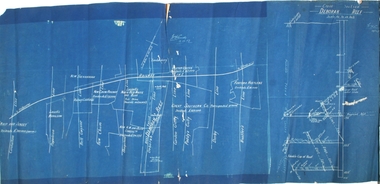 Bendigo Historical Society Inc.
Plan - Deborah Reef, 19th December, 1917
... Blue paper map, white text and plan, showing reef lines. Same plan as 11270.71, with addition of Deborah Reef cross section, on extreme right of plan. ...Reef cross section N. Cundy, 19.12.17 Blue paper map, white text and plan, showing reef lines. ...Blue paper map, white text and plan, showing reef lines. Same plan as 11270.71, with addition of Deborah Reef cross section, on extreme right of plan. N. Cundy, 19.12.17gold mining, gold, bendigo, whip and jersey, carshalton, napoleon, nell gwynne, new chum, sheepshead, garden gully, paddy gully, derby, hustlers., deborah, railway line, deborah gold mine, deborah reef, cross section -
 Bendigo Historical Society Inc.
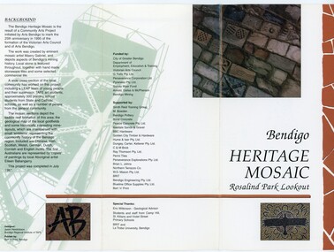
Pamphlet - MERLE HALL COLLECTION: ROSALIND PARK CREATIVE VILLAGE BENDIGO PROJECT PAMPHLET, 1995
... The sections are numbers 1 to 5 Section 1: A stylised representation of the main Bendigo Goldfield based on a geological plan (Publish in 1992). It shows the lines of reef...The sections are numbers 1 to 5 Section 1: A stylised representation of the main Bendigo Goldfield based on a geological plan (Publish in 1992). It shows the lines of reef ...Merle Hall Collection: Rosalind Park Creative Village Bendigo Project Pamphlet for Rosalind Park Lookout - two copies. One side of the pamphlet has a layout image of the five sections of the mosaic and the poppet head base. The sections are numbers 1 to 5 Section 1: A stylised representation of the main Bendigo Goldfield based on a geological plan (Publish in 1992). It shows the lines of reef, including the famous Hustlers, Garden Gully and New Chum. Section 2: A typical cross section of the Bendigo Goldfields Section 3: The mine layout shown in this design features part of the Garden Gully line of reef. Section 4: Shown here is the Iron Bark mine on the Sheepshead reef. It has an interesting pattern of drives, stopes and winzes. Section 5: In this section the artist uses gold as her inspiration. The larger mosaic shows quartz veins winding through the earth containing gold in its various forms. The smaller mosaic represents the atomic structure of gold. It shows the the nucleus, the six shells of the atom, their electrons and orbits. The other side of the pamphlet describes the background of the community arts project, the artist, and volunteer workers, also notes mentioning the Bendigo community history. It also lists the donors for funding and business's that supported the project, with special thanks to Eric Wilkinson - Geolpogical advoser, the students and staff from Camp Hill, St Killians and Violet Street primary schools. BRIT and La Trobe University, bendigo. -
Bendigo Historical Society Inc.
Map - SECTIONS ACROSS BENDIGO GOLDFIELD
... sections across Bendigo Gold Field, showing anticlines, synclines, faults, stratigraphical zones and mines along the reef lines. Key shows rock types Castlemaine, Bendigo B1, B2, B3 and B4, and Lancefieldian. First part of map shows sections A-A, B-B and C-C. Reef lines drawn with mines listed: Fault line shown are the Carshalton, Stafford, New Chum, Virginia and Clarence. A datum line shows 600 ft above sea level. On bottom of plan...reef line maps Geological Survey of Victoria Map in three sections showing sections across Bendigo Gold Field, showing anticlines, synclines, faults, stratigraphical zones and mines along the reef lines. Key shows rock types Castlemaine, Bendigo B1, B2, B3 and B4, and Lancefieldian. First part of map shows sections A-A, B-B and C-C. Reef lines drawn with mines listed: Fault line shown are the Carshalton, Stafford, New Chum, Virginia and Clarence. A datum line shows 600 ft above sea level. On bottom of plan ...Map in three sections showing sections across Bendigo Gold Field, showing anticlines, synclines, faults, stratigraphical zones and mines along the reef lines. Key shows rock types Castlemaine, Bendigo B1, B2, B3 and B4, and Lancefieldian. First part of map shows sections A-A, B-B and C-C. Reef lines drawn with mines listed: Fault line shown are the Carshalton, Stafford, New Chum, Virginia and Clarence. A datum line shows 600 ft above sea level. On bottom of plan: ' Prepared in the Geological Survey Office, Bendigo, under the direction of H. Herman, late Director of Geological Survey, from surveys by H.S. Whitelaw, Field Geologist, assisted by E.S. Usher, A.J.J. Moore and R.A. Keble.' Second section of map shows sections D-D, and E-E. Fault lines listed are the Tambour Major fault, Carshalton fault, Stafford fault, Nell Gwynne fault, New Chum fault, Deborah fault. Third section shows sections F-F and G-G. Fault lines listed are the Bird Reef fault, Kangaroo Gully fault, Langdon fault, Carshalton fault, Nell Gwynne fault, Spring Gully fault, Hustlers fault, Gravel Hill fault, Ordes fault, Thanet fault. This map forms part of the Geological Survey of Victoria, Structure of Bendigo Goldfield report, No. 47, 1923. H.Herman, late Director of Geological Survey.Geological Survey of Victoriabendigo, gold mining, reef line maps -
 Bendigo Historical Society Inc.
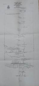
Map - COMET MINE - LONGITUDINAL SECTION COMET MINE
... section of the Comet Mine on the Hustler's Line of Reef Bulletin No 33, Plate No XXVI signed by H. S. Whitelaw, Underground Survey Office Bendigo, September 1913. Map shows datum lines, depths of levels, approximate boundaries and references to other plans. ...History House 11 Mackenzie Street Bendigo goldfields MINING Parish Map Hustler's Line of Reef Longitudinal Section of Comet Mine Bulletin No 33 Plate No XXVI H S Whitelaw Geological Survey of Victoria Longitudinal section of the Comet Mine on the Hustler's Line of Reef Bulletin No 33, Plate No XXVI signed by H. S. Whitelaw, Underground Survey Office Bendigo, September 1913. Map shows datum lines, depths of levels, approximate boundaries and references to other plans ...Longitudinal section of the Comet Mine on the Hustler's Line of Reef Bulletin No 33, Plate No XXVI signed by H. S. Whitelaw, Underground Survey Office Bendigo, September 1913. Map shows datum lines, depths of levels, approximate boundaries and references to other plans. Note - Plates 4, 8, 13, 20, 26 and 31 form a Longitudinal Section from Fortuna Hustler's to Hustler's Consols Mine. Geological Survey of Victoriamining, parish map, hustler's line of reef, longitudinal section of comet mine bulletin no 33 plate no xxvi, h s whitelaw -
 Bendigo Historical Society Inc.
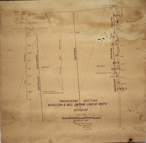
Plan - Napoleon, Nell Gwynne Transverse Section, 14.1.1946
... Printed on bottom of plan" Transverse Section Napoleon and Nell Gwynne Lines of Reef' and 'J.J. ...Printed on bottom of plan" Transverse Section Napoleon and Nell Gwynne Lines of Reef' and 'J.J. ...Napoleon Lease no.11111 is situated immediately south from the Golden Square railway station. It embraces an approx length of 36 chains of the Napoleon Anticline. The old Napoleon shaft, the depth of which is 1020 ft, occupies a central position in the area of about 43 acres. The accompanying sections, which are prepared from mine Managers plans, illustrate the extent of previous underground operations and indicate points at which future prospecting may be advantageously continued. The no.10 (920 ft) south level connects with the main Napoleon shaft no.5 level (479 ft) appears to present the best opportunity for testing the prospects that are believed to have been inadequately investigated by the Bendigo Mines Limited in recent years.Map drawn on heavy paper. Printed on bottom of plan" Transverse Section Napoleon and Nell Gwynne Lines of Reef' and 'J.J. Caldwell, District Field Geologist, Mines Department, Bendigo. 14.1.46'. Napoleon anticline and Central Nell Gwynne anticline marked on map. Map is part of the Margaret Roberts Collection of mining documents. gold mining, bendigo, napoleon gold mine, nell gwynne, reef lines, j.j. caldwell, 1946 -
 Bendigo Historical Society Inc.
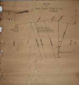
Plan - North Golden Fleece Lease, unknown
... Section of North Golden Fleece lease'. Scale 80 ft to 1 inch. Written on plan in black print: 'This belt of country contains large bodies of auriferous quartz and at present is being operated on by the New Golden Fleece Company'. Reef lines...Reef Map drawn on heavy paper, titled 'Section of North Golden Fleece lease'. Scale 80 ft to 1 inch. Written on plan in black print: 'This belt of country contains large bodies of auriferous quartz and at present is being operated on by the New Golden Fleece Company'. Reef lines ...Map drawn on heavy paper, titled 'Section of North Golden Fleece lease'. Scale 80 ft to 1 inch. Written on plan in black print: 'This belt of country contains large bodies of auriferous quartz and at present is being operated on by the New Golden Fleece Company'. Reef lines marked on plan: Ramrod Reef, Comet Reef, Stafford Reef and Frying Pan Reef. The water race, Albert shaft and open cut are marked at the surface level. This plan is part of the Margaret Roberts Collection. north golden fleece gold mine, gold mining, bendigo, lease holding, albert gold mine, ramrod reef, comet reef, stafford reef and frying pan reef -
 Bendigo Historical Society Inc.
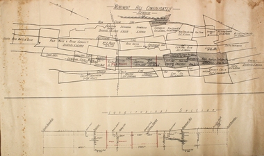
Plan - Monument Hill Consolidated Gold Mine
... Printed on buff paper, plan of leases along Sheepshead, Garden Gully, New Chum and Deborah lines of reef. Longitudinal section of mines along reef line on bottom of plan. ...gold mining gold Bendigo Monument Hill Consolidated Printed on buff paper, plan of leases along Sheepshead, Garden Gully, New Chum and Deborah lines of reef. Longitudinal section of mines along reef line on bottom of plan. ...Printed on buff paper, plan of leases along Sheepshead, Garden Gully, New Chum and Deborah lines of reef. Longitudinal section of mines along reef line on bottom of plan. Printed across top of plan: 'Monument Hill Consolidated Bendigo' Plan forms part of the Margaret Roberts Collection.gold mining, gold, bendigo, monument hill consolidated -
 Bendigo Historical Society Inc.
Plan - Pearl Gold Mine shafts
... Drawn on paper with black pen, written on top of plan 'Pearl MIne transverse section, New Chum and Sheepshead Reef lines of reef' Plan forms part of the Margaret Roberts Collection of mining records. ...Margaret Roberts gold gold mine Bendigo Pearl Gold Mine Stone Street Long Gully Drawn on paper with black pen, written on top of plan 'Pearl MIne transverse section, New Chum and Sheepshead Reef lines of reef' Plan forms part of the Margaret Roberts Collection of mining records. ...The Pearl Gold Mine was near Stone Street, Long Gully.Drawn on paper with black pen, written on top of plan 'Pearl MIne transverse section, New Chum and Sheepshead Reef lines of reef' Plan forms part of the Margaret Roberts Collection of mining records. margaret roberts, gold, gold mine, bendigo, pearl gold mine, stone street, long gully -
 Bendigo Historical Society Inc.
Plan - Parish Map of Sydney Flat
... sections including - J Dolman, G Wills, Gill, J Bayliss, Fracis Webb, T Downie, H Turner, J Hodgson, J Gordon, W Booth, J Shadbolt, J S Pearson, C Maroney, I Quin & Co, W Davey, J Kelly. Printed out of the grid is New Moon U and New Moon Cons. Added red handwriting are reef lines including - Christmas, Thistle, Carshalton, Napoleon, Gr nite, New Chum , Moon, Gully, Derby, Hustlers. There is red shading on Gully, Moon and New Chum lines. Plan ...The New Moon Group of mines were located in the Sailors Gully/ Sydney Flat area. Sydney Flat was originally regard as part of Myers Creek, later Myers Flat it was changed to Sydney Flat when mining was established and was changed to Woodvale in the 1920s Sydney Flat Bushland Reserve is near-by. The area is north of Sailors Gully.Draftsman's drawing on cream coloured waxed paper with black print. SYDNEY FLAT is printed in the centre of a grid of streets with no names divided into sections there are names many of the sections including - J Dolman, G Wills, Gill, J Bayliss, Fracis Webb, T Downie, H Turner, J Hodgson, J Gordon, W Booth, J Shadbolt, J S Pearson, C Maroney, I Quin & Co, W Davey, J Kelly. Printed out of the grid is New Moon U and New Moon Cons. Added red handwriting are reef lines including - Christmas, Thistle, Carshalton, Napoleon, Gr nite, New Chum , Moon, Gully, Derby, Hustlers. There is red shading on Gully, Moon and New Chum lines.bendigo, gold, map, mine, margaret roberts collection, new moon mines, sailors gully, sydney flat