Showing 2004 items matching " railway map"
-
 Emerald Museum & Nobelius Heritage Park
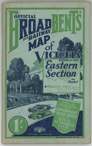
Book - Broadbent's Official Road and Railway map of Victoria, Broadbent's Official Road and Railway map of Victoria Riverina and A.C.T. Eastern Section
... Broadbent's Official Road and Railway map of Victoria... Broadbent's Official Road and Railway map of Victoria Riverina and A.C.T. Eastern Section...Broadbent's Official Road and Railway map of Victoria Riverina and A.C.T. Eastern Section Book Broadbent's Official Road and Railway map of Victoria ...The book compiles a guide on how to travel across Victoria including sights to see and places to stay.Green colouring. Old browning paper.non-fictionThe book compiles a guide on how to travel across Victoria including sights to see and places to stay. -
 Glenelg Shire Council Cultural Collection
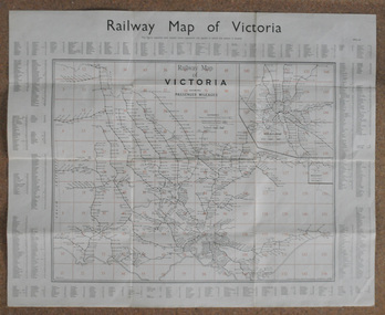
Map, Railway Map of Victoria, n.d
... Railway Map of Victoria...... railway... map...Railway map, paper on fabric backing, wooden support top and bottom edges, eye screws and hanging wire in top support....Railway Map of Victoria Map Map ...Port of Portland CollectionFront: verso - 'Way and Works branch railway Department Melbourne Dec 1954.'port of portland archives, railway, map, 1954, 1950s -
 Ballarat Tramway Museum
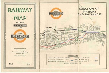
Map, NSWGR, "Railway Map of Sydney Suburban and Underground" - 1939, 1939
... "Railway Map of Sydney Suburban and Underground" - 1939...... Railway Map...Issued as No.1. Title "Railway Map of Sydney Suburban and Underground" - 1939. ...Issued as No.1. Title "Railway Map of Sydney Suburban and Underground" - 1939. ...Light card or Heavy paper. Colour map showing location of Sydney stations and entrances and where the trains ran. Issued as No.1. Title "Railway Map of Sydney Suburban and Underground" - 1939. Handle with care - both copies.trams, tramways, sydney, railway map, suburban and underground, trams -
 Sunshine and District Historical Society Incorporated
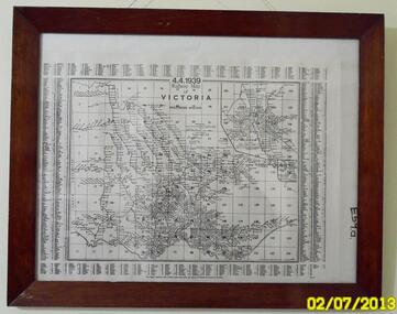
Map - Railway Map Of Victoria 1939
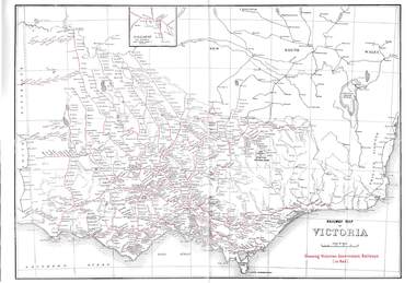
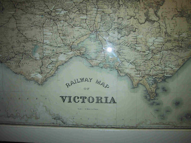
... Railway Map Of Victoria 1939...Map in frame showing the RAILWAY LINES of VICTORIA plus PASSENGER MILEAGES as of 4.4.1939. ...Railway Map of Victoria...Many of the railway lines no longer exist. Railway Railway Map of Victoria Map in frame showing the RAILWAY LINES of VICTORIA plus PASSENGER MILEAGES as of 4.4.1939. ...Historical record of the railway line system in the state of Victoria in 1939.Many of the railway lines no longer exist.Railway Map of Victoriarailway -
 Sunshine and District Historical Society Incorporated
Map - Railway Map of Victoria, Yarra Valley Railways Healesville
... Railway Map of Victoria...Map of Victoira showing Railways in 1946, Passenger Lines in 1990 and Preservation Lines...Railway Map of Victoria Railways in 1946, Passenger Lines in 1990 and Preservation Lines...Railway Railway Map of Victoria Railways in 1946, Passenger Lines in 1990 and Preservation Lines Map of Victoira showing Railways in 1946, Passenger Lines in 1990 and Preservation Lines Map Railway Map of Victoria Yarra Valley Railways Healesville ...Railway Map of Victoria Railways in 1946, Passenger Lines in 1990 and Preservation Linesrailway -
 Bendigo Historical Society Inc.
Map - RAILWAYS COLLECTION: 1946 RAILWAY MAP OF VICTORIA AUSTRALIA, 1946
... RAILWAYS COLLECTION: 1946 RAILWAY MAP OF VICTORIA AUSTRALIA...The maps shown are Railway Map of Suburban Lines Melbourne and Railways map of Victoria Showing Victorian Government Railways in red....The maps shown are Railway Map of Suburban Lines Melbourne and Railways map of Victoria Showing Victorian Government Railways in red. ...Railways Collection-1946 glossy paper Railway Map of Victoria Australia Reproduced courtesy of V/Line by the Railway Museum North Williamstown Victoria 1988 price 3 pence. The maps shown are Railway Map of Suburban Lines Melbourne and Railways map of Victoria Showing Victorian Government Railways in red.map, victoria -
 Federation University Historical Collection
Map, Railway Map of Victoria, 1930
... Railway Map of Victoria...map...railway...Cardboard map of Victorian railway system in 1930. Maps out all train-lines in Victoria and into New South Wales. ...Barker Library (top floor) Mount Helen goldfields map railway train-lines victoria Victorian Railways railway lines Cardboard map of Victorian railway system in 1930. ...Cardboard map of Victorian railway system in 1930. Maps out all train-lines in Victoria and into New South Wales. map, railway, train-lines, victoria, victorian railways, railway lines -
 Bendigo Historical Society Inc.
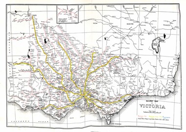
Document - RAILWAY MAP: VICTORIAN LINES 1973
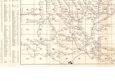
... RAILWAY MAP: VICTORIAN LINES 1973...Railway map - Victorian lines 1973 with list of stations and grid reference for location of stations. ...Shows distance from Melbourne (Spencer Street station). Document RAILWAY MAP: VICTORIAN LINES 1973 ...Railway map - Victorian lines 1973 with list of stations and grid reference for location of stations. Inset for detail of Ballarat and Melbourne lines and stations. Shows distance from Melbourne (Spencer Street station).railways, bendigo to melbourne, stations -
 Parks Victoria - Mount Buffalo Chalet
Map, "Railway Map of Victoria"
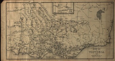
... "Railway Map of Victoria"...Large framed map of Victoria, showing Victorias extensive rail network. Printed by Victorian Railways and is one of a number of 'framed pictures, particularly photographs of scenery, which have always been a feature of the Chalet.' ...Large railway map of Victoria, Melbourne & Ballarat framed in white painted wood. ...Areas of the map have been whited out. "Railway Map of Victoria" Map ...Large framed map of Victoria, showing Victorias extensive rail network. Printed by Victorian Railways and is one of a number of 'framed pictures, particularly photographs of scenery, which have always been a feature of the Chalet.' (Pg 83. Historica, 2011) This map has been a permanent fixture situated in the hallway alongside the ballroom leading to the ski hire area since the 1950's and most likely earlier. Listed in Draft Inventory of Significant Collection ItemsLarge railway map of Victoria, Melbourne & Ballarat framed in white painted wood. Scale eight miles to one inch. Areas of the map have been whited out.Yes -
 Orbost & District Historical Society
map, Railway Map of Victoria, 1.8.1965
... Railway Map of Victoria...map-railway Victorian-Railways...A large rectangular shaped paper map of all railway stations in Victoria. It is dated 1st August 1965. ...A key is provided and each station has a grid reference. Railway Map of Victoria map Victorian Government Railways ...The Bairnsdale-Orbost railway was opened in 1916 to serve the agricultural and timber industry. Because of the decline in traffic and heavy operating costs, the line was finally closed in August, 1987.This item is associated with the history of the Orbost-Bairnsdale railway line and therefore reflects the role that the rail line played in the social and economic history of Orbost.A large rectangular shaped paper map of all railway stations in Victoria. It is dated 1st August 1965. It is divided into grids. Stations are listed around the map. A key is provided and each station has a grid reference.map-railway victorian-railways -
Whitehorse Historical Society Inc.
Map, Railway map of Victoria, 1912
... Railway map of Victoria...Detailed map of railways in Victoria including adjacent areas of New South Wales. ...Whitehorse Historical Society Inc. 2-10 Deep Creek Road Mitcham melbourne maps railways Detailed map of railways in Victoria including adjacent areas of New South Wales. ...Detailed map of railways in Victoria including adjacent areas of New South Wales.Detailed map of railways in Victoria including adjacent areas of New South Wales. Also shows 'principal coach routes'. On verso map of suburban lines with eastern line as far as Croydon and Bayswater. key numbers on map linked to pages of a timetable.Detailed map of railways in Victoria including adjacent areas of New South Wales.maps, railways -
 Bendigo Historical Society Inc.
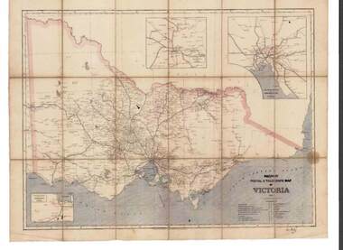
Map - RAILWAYS COLLECTION: PHOTO OF RAILWAY POSTAL & TELEGRAPH MAP OF VICTORIA 1887, 1887
... RAILWAYS COLLECTION: PHOTO OF RAILWAY POSTAL & TELEGRAPH MAP OF VICTORIA 1887......Railway Postal & Telegraph Map of Victoria 1887-...RAILWAYS COLLECTION- photo of Railway Postal & Telegraph Map of Victoria 1887- aged map showing the various Country Lines and insets show Melbourne and vicinity, Ballarat and vicinity and Geelong and vicinity....Map RAILWAYS COLLECTION: PHOTO OF RAILWAY POSTAL & TELEGRAPH MAP OF VICTORIA 1887 ...RAILWAYS COLLECTION- photo of Railway Postal & Telegraph Map of Victoria 1887- aged map showing the various Country Lines and insets show Melbourne and vicinity, Ballarat and vicinity and Geelong and vicinity.Picturesque Atlas Publishing Companyphotograph, railway postal & telegraph map of victoria 1887- -
 Kiewa Valley Historical Society
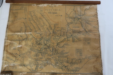
Map - Railway Map of Victoria, Amended to 1/11/1945
... Map - Railway Map of Victoria...Plastic on parchment with detailed railway routes (in green) across Victoria including each district's 'Road Foremen' and 'Depots'. There is a length of flat wood attached by 10 tacks across the top of the map...Victorian railways 1945 trains transport Plastic on parchment with detailed railway routes (in green) across Victoria including each district's 'Road Foremen' and 'Depots'. There is a length of flat wood attached by 10 tacks across the top of the map Amended to 1/11/1945 Map - Railway Map of Victoria ...Railways began in the 1850s and were privately owned and operated. Later they were taken over by the Victorian Government reaching a peak in the early 1940s.Steam trains were followed by electric trains with both running after the war in 1945.Bright was the closest station to the Kiewa Valley but road transport was used more often as the Kiewa Valley Highway was improved with the construction of the Kiewa Hydro Electric Scheme. To travel to Melbourne or Sydney by train residents went via Wodonga/Albury where they also did their shopping.Plastic on parchment with detailed railway routes (in green) across Victoria including each district's 'Road Foremen' and 'Depots'. There is a length of flat wood attached by 10 tacks across the top of the mapvictorian railways 1945, trains, transport -
 Emerald Museum & Nobelius Heritage Park
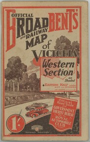
Book - Broadbent's Official Road and Railway Map of Victoria Western Section
... Broadbent's Official Road and Railway Map of Victoria Western Section...Book Broadbent's Official Road and Railway Map of Victoria Western Section ...The book was published in the 1930s - 1940s by the Broadbent's Official Road Guides Co. The book compiles a guide of how to travel across Victoria's western section and lists places to see and stay as a tourist.The item has significance as it gives insight into how tourists travelled in the early to mid 1900s across Victoria.Paperback book, paper browning. Red and black colouring on front and back. -
 Montmorency–Eltham RSL Sub Branch
Map - Burma Railway Map (annotated)
... Burma Railway Map (annotated)...Fold-out sheet of paper showing and describing the details of locations along the railway; part of a numbered series of maps...Montmorency–Eltham RSL Sub Branch Petrie Park 16 Mountain View Road Montmorency melbourne Fold-out sheet of paper showing and describing the details of locations along the railway; part of a numbered series of maps Map Burma Railway Map (annotated) ...Fold-out sheet of paper showing and describing the details of locations along the railway; part of a numbered series of maps -
 Bendigo Historical Society Inc.
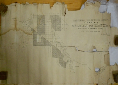
Map - MARKS COLLECTION: TRAMWAY OR RAILWAY MAP SANDHURST
... MARKS COLLECTION: TRAMWAY OR RAILWAY MAP SANDHURST...Map...Marks collection...railway...Original map of 'land granted as endowment' for tramway or railway. On top Rh corner of map, in bold print 'Sandhurst, Inglewood & Loddon district Tramway or Railway. ...Map MARKS COLLECTION: TRAMWAY OR RAILWAY MAP SANDHURST ...Original map of 'land granted as endowment' for tramway or railway. On top Rh corner of map, in bold print 'Sandhurst, Inglewood & Loddon district Tramway or Railway. Land granted as endowment shaded, scale 60 chains to 1 inch. Lithographed by J & W. Holmes, Lith. Sandhurst'. Signed by Geo Avery Fletcher, Engineer. Map shows Parish of Leichardt, Parish of Yarraberb, Parish of Bridgwater and a section of Marong. On bottom RH corner, is small map of Sandhurst, showing railway reserve. Top LH corner, Inglewood. Map shows route of railway line from Sandhurst to Inglewood.map, marks collection, railway, inglewood -
 Bendigo Historical Society Inc.
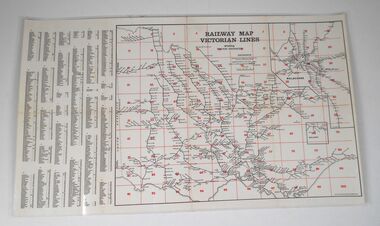
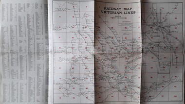
Map - Courtis-Cowling Collection: Railway Map Victorian lines, 1976
... Courtis-Cowling Collection: Railway Map Victorian lines...Laminated map of the Railway lines of Victoria. Printed in black and white and red on cream coloured light-coloured card. ...Issued by the Victorian Railways 1976. Map Courtis-Cowling Collection: Railway Map Victorian lines ...Laminated map of the Railway lines of Victoria. Printed in black and white and red on cream coloured light-coloured card. Includes an alphabetical list of all stations in Victoria. Shows station distances. Issued by the Victorian Railways 1976. black lacquer box, snuff, porcelain, courtis -
Ringwood and District Historical Society
Envelope, Packet: War Workers (WW2) - Fall of Singapore, Burma Railway Map, Special Editions of Newspapers 1992-993
... Packet: War Workers (WW2) - Fall of Singapore, Burma Railway Map, Special Editions of Newspapers 1992-993...World War II - Newspapers - 50th anniversary editions; The Australian - Special edition "The Fall of Singapore", "The Day Destiny Struck", Australia at War, Map of Burma Railway...Ringwood and District Historical Society 125A Warrandyte Road Ringwood North melbourne World War II - Newspapers - 50th anniversary editions; The Australian - Special edition "The Fall of Singapore", "The Day Destiny Struck", Australia at War, Map of Burma Railway Packet: War Workers (WW2) - Fall of Singapore, Burma Railway Map, Special Editions of Newspapers 1992-993 Envelope ...World War II - Newspapers - 50th anniversary editions; The Australian - Special edition "The Fall of Singapore", "The Day Destiny Struck", Australia at War, Map of Burma Railway -
 Hymettus Cottage & Garden Ballarat
Work on paper - Map, Railway Map Victorian Lines
... Railway Map Victorian Lines...Hymettus Cottage & Garden Ballarat 8 Cardigan St Lake Wendouree goldfields Victorian Railways Railway Map Victorian Lines Work on paper Map ...non-fictionvictorian railways -
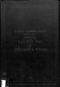 Victorian Railway History Library
Book, Railway Clearing House, Railway Clearing House Official Railway Map of England & Wales, 1947
... Railway Clearing House Official Railway Map of England & Wales...Railway Clearing House Official Railway Map of England & Wales Book Railway Clearing House ...A large fold out map of the railways of England, Wales & the south of Scotland just prior to nationalisation into British Rail.maps, p.1.non-fictionA large fold out map of the railways of England, Wales & the south of Scotland just prior to nationalisation into British Rail.railroads - great britain - maps, railroads - great britain - history -
 Bendigo Historical Society Inc.
Photograph - RAILWAY PHOTOGRAPHS
... ...Railway map 1887...Railway Photographs Disc 1 1887 Railways Map - Disc 2...Railway Photographs Railway map 1887 DVD. Railway Photographs Disc 1 1887 Railways Map - Disc 2 Photograph RAILWAY PHOTOGRAPHS ...DVD. Railway Photographs Disc 1 1887 Railways Map - Disc 2railway photographs, railway map 1887 -
 Bendigo Historical Society Inc.
Map - RAILWAY POSTAL & TELEGRAPH MAP OF VICTORIA, 1887
... RAILWAY POSTAL & TELEGRAPH MAP OF VICTORIA...MAP...Victoria...railway...Railway Postal & Telegraph Map of Victoria 1887 printed on canvas in a fold out book form with name printed on back F.L.Outtrim, in a cardboard cover with red and blue pattern....Map RAILWAY POSTAL & TELEGRAPH MAP OF VICTORIA ...Railway Postal & Telegraph Map of Victoria 1887 printed on canvas in a fold out book form with name printed on back F.L.Outtrim, in a cardboard cover with red and blue pattern.Picturesque Atlas Publishing Co Ltd Sydney & Melbournemap, victoria, railway -
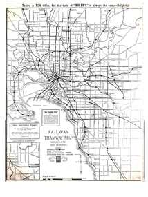 Melbourne Tram Museum
Map, Gawler and Drummond Architects, "Railway and Tramway Map of Melbourne and Suburbs", 1920's?
... "Railway and Tramway Map of Melbourne and Suburbs"...Map - photocopy - titled "Railway and Tramway Map of Melbourne and Suburbs", c1920 showing railways, cable, electric tramways and authorised electric additions. ...Melbourne Tram Museum 8 Wallen Road Hawthorn melbourne Trams tramways Map Footscray St Kilda New Tramway Melbourne Tourism Map - photocopy - titled "Railway and Tramway Map of Melbourne and Suburbs", c1920 showing railways, cable, electric tramways and authorised electric additions. ...Map - photocopy - titled "Railway and Tramway Map of Melbourne and Suburbs", c1920 showing railways, cable, electric tramways and authorised electric additions. Shows the South Melbourne St Kilda tram line and some lines in the Footscray area as dotted. Prepared by Gawler and Drummond Architects. Has an advertisement for "Rolfes" tea along the top edge and "See Victoria First" - Government Tourist Office, corner of Swanston and Collins St.trams, tramways, map, footscray, st kilda, new tramway, melbourne, tourism -
 Kew Historical Society Inc
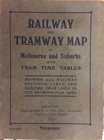
Map, Osboldstone & Co Pty Ltd, Railway and Tramway Map of Melbourne and Suburbs With Tram Timetables, 1917
... Railway and Tramway Map of Melbourne and Suburbs With Tram Timetables...The Railway and Tramway Map of Melbourne and Suburbs With Tram Timetables lists existing Cable Tram Services before the entire network was electrified. ...Kew Historical Society Inc Kew Court House 188 High Street Kew melbourne The Railway and Tramway Map of Melbourne and Suburbs With Tram Timetables lists existing Cable Tram Services before the entire network was electrified. ...The Railway and Tramway Map of Melbourne and Suburbs With Tram Timetables lists existing Cable Tram Services before the entire network was electrified. By 1917 the tramways system was divided into regions including: the Melbourne Cable Tram Service; Prahran - Malvern Electric Trams; Hawthorn Electric Trams; Melbourne, Brunswick and Coburg Electric Trams; and Brighton Beach Electric Trams. The old Outer Circle railway line is marked as ending in Deepdene, with the remainder of the line to Fairfield marked as 'Unused'. The Kew tram along High Street in 1917 ended at the Harp Junction. The Kew Spur Line is also marked on the map.The Railway and Tramway Map of Melbourne and Suburbs With Tram Timetables is historically significant as it captures at a point in time, 1917, the development of public transport infrastructure in Melbourne. As such it illustrrates the theme: Connecting Victorians by transport and communications.Printed card-covered pocket sized map that folds out with three horizontal and vertical folds. Colour map, with scale, of the rail and tram networks on one side and sixteen sections of black and white printed text and timetable information on the reverse.railway maps -- melbourne (vic.), tramways maps -- melbourne (vic.), public transport -- melbourne (vic.) -- 1910-1920, cartography -
 Ballarat Tramway Museum
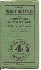
Ephemera - Timetable/s, Osboldstone & Co Pty Ltd and Printers and Publishers Melbourne, "OSBA Tram Time Tables with Railway and Tramway Map, of Melbourne and Suburbs", 1920's
... "OSBA Tram Time Tables with Railway and Tramway Map, of Melbourne and Suburbs"...Forty Eight page printed book contained with oversize green heavy paper covers centre stapled with a coloured map glued into the rear cover of the book titled "OSBA Tram Time Tables with Railway and Tramway Map, of Melbourne and Suburbs". ...Map folded into 12 sections. Published by Osboldstone & Co Pty Ltd, Printers and Publishers, Temple Court Place, Melbourne. Price 6d. Full scan of document added as a pdf file 5/6/2019. "OSBA Tram Time Tables with Railway ...Yields information about the tram timetables applicable to Melbourne's trams, including cable and electric and demonstrates the spread of Melbourne's public transport system in the early 1920's.Forty Eight page printed book contained with oversize green heavy paper covers centre stapled with a coloured map glued into the rear cover of the book titled "OSBA Tram Time Tables with Railway and Tramway Map, of Melbourne and Suburbs". Published c1920 - shows Footscray system, Victoria St Flemington link, does not show Puckle St. Timetables details Fares, first and last cars for cable and electric lines, sections and other details of the various lines. Note page 44 and 45 cannot be accessed, paper not cut correctly during the printing process - leave as is. Map prepared by Gawler and Drummond Architects, shows in colour the cable routes, electric tramways, authorised tramways and railway lines. Municipalities shown in different colours. Map folded into 12 sections. Published by Osboldstone & Co Pty Ltd, Printers and Publishers, Temple Court Place, Melbourne. Price 6d. Full scan of document added as a pdf file 5/6/2019. map, timetables, melbourne, cable trams -
 Dandenong/Cranbourne RSL Sub Branch
Document - Framed Information Sheet, About The Map, Circa 2000s
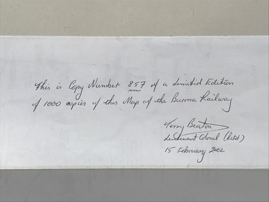
... The information sheet belongs with a map showing the Burma Thailand Railway and it's route with the various camps and P.O.W centres. ...Framed information sheet of the map produced to show the various camps and sights along the Burma Thailand railway. ...The map was produced using a number of older railway maps, including the Escritt translated map and a local Thai road touring map....The map was produced using a number of older railway maps, including the Escritt translated map and a local Thai road touring map. ...The information sheet belongs with a map showing the Burma Thailand Railway and it's route with the various camps and P.O.W centres. The map was produced over a period of 15 months and drawn in four stages. Shows Hellfire Pass formerly ( The Konyu Cutting). The 50 Kilo Camp in Burma. There were 56 stations and 87 camps on the route of the map. The map gives due credibility and was released as a limited edition of 1000 copies only. Copies of the map are displayed all over the world including Staffordshire in England, University of Houston, National Guard Museum of Texas and on display at the Australian and New Zealand Embassies in Bangkok.Framed information sheet of the map produced to show the various camps and sights along the Burma Thailand railway. The map was produced using a number of older railway maps, including the Escritt translated map and a local Thai road touring map. -
 Federation University Historical Collection
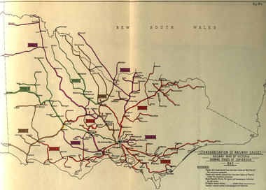
Book, Standardization of Australia's Railway Gauges, 1945, 1945
... : * Map of Australia showing the various proposals referred to *Map of Australian railways showing extent of standard gauge if proposals are carried out * Map of Australian railways as of 30 June 1944 *Map of Australia showing principal mileages referred to in the report * Railway Map of Western Australia, 1945 * Railway Map of South Australia, 1945 * Railway Map of Victoria, 1945 * Railway Map of Melbourne Suburbs, 1945 ...: * Map of Australia showing the various proposals referred to *Map of Australian railways showing extent of standard gauge if proposals are carried out * Map of Australian railways as of 30 June 1944 *Map of Australia showing principal mileages referred to in the report * Railway Map of Western Australia, 1945 * Railway Map of South Australia, 1945 * Railway Map of Victoria, 1945 * Railway Map of Melbourne Suburbs, 1945 Standardization of Australia's Railway Gauges, 1945 Book Book H.E. ...Sir Harold Winthrop Clapp KBE (7 May 1875 – 21 October 1952) was a transport administrator who over the course of thirty years had a profound effect on Australia's railway network. In two decades as its Chairman of Commissioners, he revolutionised Victorian Railways, with unprecedented attention to customer service and innovations such as more powerful locomotives, air-conditioned carriages, and faster services culminating in the introduction of the flagship Spirit of Progress express train. Seconded to the Federal Government in World War II, he played a pivotal role in the manufacture of fighter aircraft in the defence of Australia. As Director-General of Australia's Land Transport Board, he presented a report on railway gauge standardisation that ultimately led to the eventual linking of all Australian mainland capital cities by a uniform rail gauge. (http://en.wikipedia.org/wiki/Harold_Winthrop_Clapp, accessed 02/10/2013)Grey, soft covered, stapled report of 89 pages. "Standardization of Australia's Railway Gauges" by Harold Clapp is a report and recommendation regarding the standarization of Australia's railway gauges. The contents include: * Lines suggested for conversion or new lines to be constructed * scheme of conversion of tracks and structures * scheme of conversion of locomotives and rolling stock * Estimated costs * Associated works * Estimated manpower which the project will absorb in its various phases *Standardization of rolling stock * Other considerations associated with the project * Estimated time involved in the various phases of the work. The report includes 8 maps: * Map of Australia showing the various proposals referred to *Map of Australian railways showing extent of standard gauge if proposals are carried out * Map of Australian railways as of 30 June 1944 *Map of Australia showing principal mileages referred to in the report * Railway Map of Western Australia, 1945 * Railway Map of South Australia, 1945 * Railway Map of Victoria, 1945 * Railway Map of Melbourne Suburbs, 1945 railway, guage, standardization, standardisation, fremantle, perth, kalgoorlie, peterborough, silverton, tramway, tram, train, townsville, dajarra, bourke, cunnamulla, charleville, blackall, longreach, winton, hughenden, townsville, gajarra, birdum, darwin, narrow gauge -
 Bendigo Historical Society Inc.
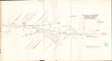
Document - BADHAM COLLECTION: VICTORIAN RAILWAYS MAP - NTH BENDIGO JUNCTION SIGNALLING DIAGRAM NO 4'80
... Victorian railways map: Nth Bendigo junction signalling diagram no 480 showing signal and interlocking arrangements. ...Document BADHAM COLLECTION: VICTORIAN RAILWAYS MAP - NTH BENDIGO JUNCTION SIGNALLING DIAGRAM NO 4'80 ...Victorian railways map: Nth Bendigo junction signalling diagram no 480 showing signal and interlocking arrangements. Large paper map, A F chief electrical engineer 9.1.1980. Black ink diagram and writing.document, memo, railway, nth bendigo junction signalling diagram no 4'80 -
Whitehorse Historical Society Inc.
Document, McGlone's Estate Mitcham, 1/04/1921 12:00:00 AM
... Mitcham Railway Station...Haughton Map...Bordered by Whitehorse Road, McGlone Street, Station Street and Mitcham railway line and station. Original in Haughton maps, LaTrobe Library....Bordered by Whitehorse Road, McGlone Street, Station Street and Mitcham railway line and station. Original in Haughton maps, LaTrobe Library....Land Sales Auctions McGlone John McGlone Elizabeth Whitehorse Road Mitcham McGlone Street Mitcham Station Street Mitcham Mitcham Railway Station Haughton Map Collection State Library of Victoria. ...Copy of pamphlet of McGlone's Estate, Mitcham auctioned April 1921.Copy of pamphlet of McGlone's Estate, Mitcham auctioned April 1921. 24 allotments. Bordered by Whitehorse Road, McGlone Street, Station Street and Mitcham railway line and station. Original in Haughton maps, LaTrobe Library.Copy of pamphlet of McGlone's Estate, Mitcham auctioned April 1921. land sales, auctions, mcglone, john, mcglone, elizabeth, whitehorse road, mitcham, mcglone street, mitcham, station street, mitcham, mitcham railway station, haughton map collection, state library of victoria. latrobe library -
Port Melbourne Historical & Preservation Society
Flyer, Victorian Railways, Sandridge Rail Trail, 2005
... Fold out section has history of railway, map, walk and ride descriptions...Fold out section has history of railway, map, walk and ride descriptions Sandridge Rail Trail Flyer Victorian Railways ...Fold out flyer with black and white picture of train and three men on front cover. Back cover coloured image from Latrobe picture collection of park-like setting with steam train in background. Fold out section has history of railway, map, walk and ride descriptionstransport - railways, recreation, piers and wharves - station pier, piers and wharves - railway pier, hobson's bay railway company, melbourne and hobson's bay united railway company, montague street station, golden fleece hotel, st barnabas anglican church, north port station, lord raglan hotel