Showing 10 items matching " route 132"
-
 Melbourne Tram Museum
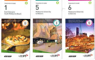
Ephemera - Tram Route Guides, Public Transport Victoria (PTV), "Tram Route Guide", Feb. 2016
... ... Route 132...Melbourne Tram Museum 8 Wallen Road Hawthorn melbourne Trams tramways Timetables Maps Route 1 Route 5 Route 6 Route 8 Route 11 Route 16 Route 132 Route 19 Route 30 Route 48 Route 55 Route 57 Route 59 Route 64 Route 67 Route 70 Route 72 Route 75 Route 78 Route 82 Route 86 Route 96 Route 109 East Coburg West Coburg Airport West North Coburg South Melbourne Malvern Glen Iris Moreland Toorak West Maribyrnong Wattle Park Docklands Camberwell Vermont South Footscray Moonee Ponds St Vincent's Plaza Victoria Gardens East Brighton North Richmond Balaclava Bundoora East Brunswick West Preston Kew North Balwyn Carnegie Box Hill Item 11 has the "5" changed to "8" in Texta - see history of object. ...Set of 18 Tram Route Guides, published during 2016. Each comprises a vertical DL folded sheet, full colour for the nominated routes, with Yarra Trams and PTV logos, listing the stops, interchanges with bus and other tram services, ticketing zones, estimated frequencies with adverts for Night tram services, TramTracker and Myki tickets. .1 - Route 1 - East Coburg to South Melbourne Beach .2 - Route 5 - Melbourne University to Malvern .3 - Route 6 - Melbourne University to Glen Iris .4 - Route 8 - Moreland to Toorak .5 -Route 57 - West Maribyrnong to Flinders St Station (2 copies) .6 - Route 70 - Wattle Park to Waterfront City Docklands .7 - Route 72 - Melbourne University to Camberwell .8 - Route 75 - Vermont South to Etihad Stadium / Bourke St Docklands .9 - Route 82 - Footscray to Moonee Ponds .10 - Route 19 - North Coburg to Flinders St Station .11 - Route 55 - West Coburg to Domain Interchange (two copies held) .12 - Route 59 - Airport West to Flinders St Station .13 - Route 30 - St Vincent's Plaza to Ethida Stadium Docklands .14 - Route 12 - Victoria Gardens to St Kilda / Fitzroy St .15 - Route 64 - Melbourne University to East Brighton .16 - Route 78 - North Richmond to Balaclava (via Prahran) .17 - Route 86 - Bundoora (RMIT) to Waterfront City Docklands .18 - Route 96 - East Brunswick to St Kilda Beach .19 - Route 11 - West Preston to Victoria Harbour Docklands ,20 - Route 16 - Melbourne University to Kew via St Kilda .21 - Route 48 - North Balwyn to Victoria Harbour Docklands .22 - Route 67 - Melbourne University to Carnegie .23 - Route 109 - Box Hill to Port Melbourne See Reg Item 2396 for 2012, 2939 for 2015 and 2940 for 2014 versions Items .13 to .18 added 2/9/18Item 11 has the "5" changed to "8" in Texta - see history of object.trams, tramways, timetables, maps, route 1, route 5, route 6, route 8, route 11, route 16, route 132, route 19, route 30, route 48, route 55, route 57, route 59, route 64, route 67, route 70, route 72, route 75, route 78, route 82, route 86, route 96, route 109, east coburg, west coburg, airport west, north coburg, south melbourne, malvern, glen iris, moreland, toorak, west maribyrnong, wattle park, docklands, camberwell, vermont south, footscray, moonee ponds, st vincent's plaza, victoria gardens, east brighton, north richmond, balaclava, bundoora, east brunswick, west preston, kew, north balwyn, carnegie, box hill -
 Ballarat Tramway Museum
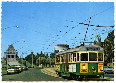
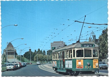
Postcard, Nu-color-vue or Nucolorvue Productions, MMTB tram No. SW5 834 southbound in St Kilda Road
... route 3. Has ads on ends and side of tram, but out of focus. One is for "Dufor Engine Valves" Card by Nucolorvue. On rear of card printed in dark green ink is "MELBOURNE, VICTORIA/ St. Kilda Road with tram and Shine of Remembrance." Also wording for stamp location, copyright etc. On left hand edges is "ML 132...route 3. Has ads on ends and side of tram, but out of focus. One is for "Dufor Engine Valves" Card by Nucolorvue. On rear of card printed in dark green ink is "MELBOURNE, VICTORIA/ St. Kilda Road with tram and Shine of Remembrance." Also wording for stamp location, copyright etc. On left hand edges is "ML 132 ...Colour postcard with serrated edges of MMTB tram No. SW5 834 southbound in St Kilda Road with the Shine of Remberance in the background. Has as number of parked motor cars on either side of the road. Tram is showing destination of "East Malvern - Darling Road", route 3. Has ads on ends and side of tram, but out of focus. One is for "Dufor Engine Valves" Card by Nucolorvue. On rear of card printed in dark green ink is "MELBOURNE, VICTORIA/ St. Kilda Road with tram and Shine of Remembrance." Also wording for stamp location, copyright etc. On left hand edges is "ML 132", Set EW. Second copy added 21/07/2001. Card is ML 132 NCV1106 - a lot more sharper or in focus card, different colours.trams, tramways, melbourne, st kilda road -
 Ballarat Tramway Museum
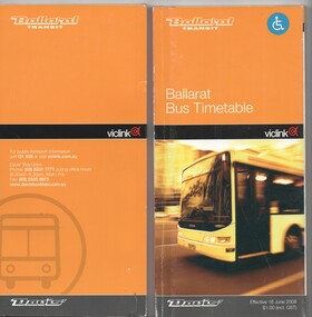
Ephemera - Timetable, Ballarat Transit and Viclink, "Ballarat Bus Timetable", 2008
... Timetable - perfect bound, 132 pages + covers with fold out map on the front cover, titled "Ballarat Bus Timetable", dated 16 June 2008, with Ballarat Transit, VicLink and Davis Bus logos. Lists the 18 timetable routes...Ballarat Tramway Museum South Gardens Reserve Wendouree Parade Ballarat Ballarat goldfields Ballarat Public Transport Buses Davis Bus Lines Timetables Timetable - perfect bound, 132 pages + covers with fold out map on the front cover, titled "Ballarat Bus Timetable", dated 16 June 2008, with Ballarat Transit, VicLink and Davis Bus logos. Lists the 18 timetable routes ...Timetable - perfect bound, 132 pages + covers with fold out map on the front cover, titled "Ballarat Bus Timetable", dated 16 June 2008, with Ballarat Transit, VicLink and Davis Bus logos. Lists the 18 timetable routes at the time, how to get to the various tourist attractions including the BTM. Has the various contact details on the rear cover. Two copies held.ballarat public transport, buses, davis bus lines, timetables -
 Wodonga & District Historical Society Inc
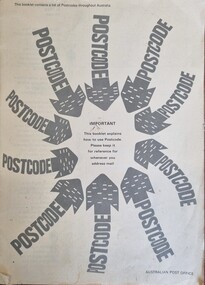
Booklet - Postcode Instruction Book, Australia Post, 1967
... 132 Bonegilla Road Bonegilla the-murray This booklet documents a major change in Australian postal services. Australian mail services Australia Post Postcodes The use of postcodes was introduced in Australia on Saturday, 1 July 1967 by the Postmaster General's department. They are used to more efficiently sort and route ...The use of postcodes was introduced in Australia on Saturday, 1 July 1967 by the Postmaster General's department. They are used to more efficiently sort and route mail within AUstralia. In July 1967, the first edition of the Postcode Booklet was distributed free by mail to every Australian household and business address. A total of 4.5 million booklets were distributed, as well as a postcard identifying the recipient’s own postcode. Originally the four digit postcodes were developed for electronic mail handling equipment at the former Redfern Mail Exchange in Sydney. This was extended to cover all locations in Australia and continues to grow as new residential areas are developed.A small booklet issued by the Australian Post Office to explain the use of post codes 1967. It outlines how to use a postcode, advice for businesses to ensure their correct use and a list of all the postcodes allocated throughout Australia at that time. Two other booklets are updated lists of postcodes.non-fictionThe use of postcodes was introduced in Australia on Saturday, 1 July 1967 by the Postmaster General's department. They are used to more efficiently sort and route mail within AUstralia. In July 1967, the first edition of the Postcode Booklet was distributed free by mail to every Australian household and business address. A total of 4.5 million booklets were distributed, as well as a postcard identifying the recipient’s own postcode. Originally the four digit postcodes were developed for electronic mail handling equipment at the former Redfern Mail Exchange in Sydney. This was extended to cover all locations in Australia and continues to grow as new residential areas are developed.australian mail services, australia post, postcodes -
 Wodonga & District Historical Society Inc
Book - Touring Murray River Country, Stone, Derrick I & Stone, Sascha C, 1996
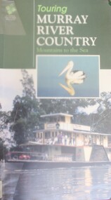
... Wodonga & District Historical Society Inc Hut 97, Bonegilla Migrant Experience, 132 Bonegilla Road Bonegilla the-murray Murray River Australia - Tourism A touring guide of the Murray RIver, Australia from its source in the mountains following its journey to the sea. The first sections cover information about the area of the Upper Murray, including Lake Hume and the Albury-Wodonga area. A publication of 128 pages includes 230 full colour photos, 42 illustrations and 19 colour route ...A touring guide of the Murray RIver, Australia from its source in the mountains following its journey to the sea. The first sections cover information about the area of the Upper Murray, including Lake Hume and the Albury-Wodonga area.A publication of 128 pages includes 230 full colour photos, 42 illustrations and 19 colour route maps. A touring guide of the Murray RIver, Australia from its source in the mountains following its journey to the sea. The first sections cover information about the area of the Upper Murray, including Lake Hume and the Albury-Wodonga area.murray river, australia - tourism -
 Wodonga & District Historical Society Inc
Photograph - The River Port of Red Bank
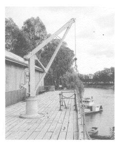
... 132 Bonegilla Road Bonegilla the-murray THE RIVER PORT OF REDBANK During the 1870s, Red Bank would have been one of the busiest ports on the Murray River. When the railway line was being built from Melbourne to Wodonga all the railway material was brought up river from Echuca by paddle steamer and barge and unloaded at Red Bank. The material was loaded onto horse teams or bullock wagons and taken along the route ...THE RIVER PORT OF REDBANK During the 1870s, Red Bank would have been one of the busiest ports on the Murray River. When the railway line was being built from Melbourne to Wodonga all the railway material was brought up river from Echuca by paddle steamer and barge and unloaded at Red Bank. The material was loaded onto horse teams or bullock wagons and taken along the route of the spur line. During the 187 MacCulloch & Co. handled 3000 tons of railway material here' The port was operational from approximately 1870 until 1874. THE FIG TREES The fig trees and a small bank of gravel are the only visible reminders of where the spur line from the wharf at Red Bank met the main line. It was at this point that all the material for the mainline was transferred from the small locomotives and wagons from Red Bank. It would have been carried by bullock wagons and horse teams and unloaded at different places as the line progressed. After the line was completed in 1873 the fettlers from Wodonga would patrol this length of the line.These images are significant because they document an important stage in the development of transportation in North East Victoria.Images of the River Port of Red bank near Wodonga on the Murray River. 1. The wharf 2. All that remainsred bank port, historic wharf wodonga, river transport -
 Wodonga & District Historical Society Inc
Memorabilia - Hume and Hovell Centenary Race Meeting - Albury
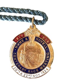
... Wodonga & District Historical Society Inc Hut 97, Bonegilla Migrant Experience, 132 Bonegilla Road Bonegilla the-murray Great celebrations took place in Albury, NSW for the celebration of the Centenary of the Hume and Hovell expedition. The Hume and Hovell journey of discovery to Port Phillip took place during 1824-1825. On November 20, 1824, they successfully crossed the Murray River not far from Albury and proceeded on a route ...Great celebrations took place in Albury, NSW for the celebration of the Centenary of the Hume and Hovell expedition. The Hume and Hovell journey of discovery to Port Phillip took place during 1824-1825. On November 20, 1824, they successfully crossed the Murray River not far from Albury and proceeded on a route to Port Phillip. To celebrate the Centenary of this crossing, the city of Albury held a series of activities during the week of Sunday 16th November to Saturday 22nd November 1924. As part of these celebrations the Albury Race Club held a special race meeting conducted on Thursday 20th and Saturday 22nd November 1924. This badge was produced as a memorabilia for that meeting. Prize money over the two day meeting totalled over £3,000. The star events were the Centenary Cup of I mile and 3 furlongs with a prize of £1000 (one thousand pounds) and a Gold Cup valued at one hundred guineas, donated by Mrs. Jas. Mitchell of Tabletop, and the John Campbell Handicap of one mile carrying $500 and trophy valued at 50 guineas donated by the chairman of the Club, Mr. J. Campbell. A gold whip donated by Mr. Norman Crow was presented to the jockey riding the Cup winner. This item is significant because it is an example of memorabilia produced for the centenary celebrations for the Hume and Hovell Expedition.An enamelled fob medallion featuring a central image with a tree at the top and text. The tree is the Hovell Tree at Albury. The central image is of indigenous man facing Albury’s civic buildings with the Murray River in between. The fob is attached to a blue twisted cord.1824 1924 HUME & HOVELL CENTENARY RACE MEETING 20th and 22nd Nov 1924 On back: 244B SIMPSONhume & hovell, hume & hovell centenary, albury race club -
 Wodonga & District Historical Society Inc
Photograph - Wodonga Creek Stock Bridge Collection
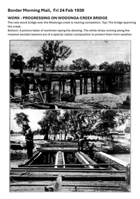
... 132 Bonegilla Road Bonegilla the-murray The Wodonga Creek Stock Bridge was constructed by the Country Roads Board in 1939. The date was recorded on a small plaque attached to one of the trestles. The bridge is an important reminder of one of the industries Wodonga was built on — cattle. It was constructed to develop a new stock route ...The Wodonga Creek Stock Bridge was constructed by the Country Roads Board in 1939. The date was recorded on a small plaque attached to one of the trestles. The bridge is an important reminder of one of the industries Wodonga was built on — cattle. It was constructed to develop a new stock route between Albury and Wodonga which would direct cattle away from the main bitumen roads and traffic bridges to the Wodonga Saleyards, where thousands of sheep and cattle were sold each month. It is a moderately tall timber trestle road bridge consisting of nine spans, with a deck length of 76 metres and deck width of 4.5 metres, and a maximum span length of 8.5 metres. The substantial timber deck featured decking laid horizontally and longitudinal running planks laid on top of it. The bridge also has timber side safety rails to discourage livestock from straying over the side. The bridge also became the centre of summer social activity for the young people of Wodonga as the area became a gazetted swimming area before the Wodonga Swimming Pool was constructed in 1959. In 1980 the Wodonga Saleyards were relocated to Bandiana to the east of the city. This meant that Wodonga Creek Stock Bridge was no longer needed for its original purpose. Although listed as a significant site by the Victorian Heritage and National Heritage Trust on 3/08/1998, the bridge fell into disrepair and also suffered damage from several floods. A suspension Bridge was constructed beside the Stock Route Bridge in 2013 and the old bridge was closed to traffic. Major damage caused by several floods, including a major flood in 2022 has resulted in the bridge being unsafe and its future is uncertain. The model of the Wodonga Creek Stock Bridge in our Collection made by Mr John Wild, depicts its current condition.The Wodonga Creek Stock Bridge is significant for technical, historic and social reasons and has been registered at the State Heritage level. It is of technical significance as a nine span bridge with tall timber trestles. Large bridges of this type are now very rare in Victoria. It is of historic significance as a surviving structurally authentic bridge designed specifically for livestock and drover use, on a historic stock route. The Stock Bridge is of social significance for its location at a popular riverside leisure spot since its construction in 1939.A collection of photographic images depicting the Wodonga Creek Stock Bridge. It contains both black and white and coloured images taken at different times in the Stock Bridge's history. A model of the Bridge made for Our Society is also included.wodonga creek stock bridge, wodonga heritage -
 Wodonga & District Historical Society Inc
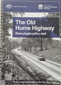
Book - The Old Hume Highway - History begins with a Road, 2014
... Wodonga & District Historical Society Inc Hut 97, Bonegilla Migrant Experience, 132 Bonegilla Road Bonegilla the-murray This publication is significant because it highlights the location and history of small towns along the New South Wales section of the Hume Highway. Old Hume Highway hume highway Travel Guide Hume Highway \ The Hume Highway was officially named in 1928, when both the New South Wales and Victorian governments agreed to give the unified inland route between Sydney and Melbourne the name, honouring explorer Hamilton Hume who, with William Hovell, first found the overland path in 1824. ...The Hume Highway was officially named in 1928, when both the New South Wales and Victorian governments agreed to give the unified inland route between Sydney and Melbourne the name, honouring explorer Hamilton Hume who, with William Hovell, first found the overland path in 1824. Much of the original highway followed their overland route wherever the landscape allowed. The road connected many small communities and rural properties, although in many parts was narrow and unsurfaced. Over the following years alterations and some deviations occurred with changing transport needs and heavier traffic loads. One of these deviations was completed in 1933 at Table Top north of Albury between Ettamogah and Mullengandra due to the construction of the Hume Weir which flooded the existing highway. Gradually sections of the road were converted to a dual carriageway. In 1961 the first modern freeway-standard, four-lane section was completed in Victoria at Craigieburn. The Hume Highway was also rerouted in Albury to avoid the town centre. Many major bypasses and duplications in New South Wales were completed throughout the 1980s and 1990s. In 1994 the last section of the Hume Highway in Victoria was duplicated with the completion of the Wangaratta bypass. The Albury-Wodonga bypass was opened in 2007 and in 2013 the final section, the Holbrook Bypass in NSW, was opened to traffic on August 7, completing the full Sydney-Melbourne dual carriageway link. In the course of this gigantic engineering achievement, many small, historic towns throughout Victoria and New South Wales were bypassed and often forgotten by passing commuters in a rush to reach their destination. This publication includes maps and information about the sites and landmarks in these towns. It encourages travellers to venture of the modern highway and rediscover the Old Hume Highway and the stories it holds about out past.A spiral bound volume of 122 pages including maps, photographs and illustrations prepared as a travel guide to the Old Hume Highway. It includes a Foreword by Peter FitzSimons.The Hume Highway was officially named in 1928, when both the New South Wales and Victorian governments agreed to give the unified inland route between Sydney and Melbourne the name, honouring explorer Hamilton Hume who, with William Hovell, first found the overland path in 1824. Much of the original highway followed their overland route wherever the landscape allowed. The road connected many small communities and rural properties, although in many parts was narrow and unsurfaced. Over the following years alterations and some deviations occurred with changing transport needs and heavier traffic loads. One of these deviations was completed in 1933 at Table Top north of Albury between Ettamogah and Mullengandra due to the construction of the Hume Weir which flooded the existing highway. Gradually sections of the road were converted to a dual carriageway. In 1961 the first modern freeway-standard, four-lane section was completed in Victoria at Craigieburn. The Hume Highway was also rerouted in Albury to avoid the town centre. Many major bypasses and duplications in New South Wales were completed throughout the 1980s and 1990s. In 1994 the last section of the Hume Highway in Victoria was duplicated with the completion of the Wangaratta bypass. The Albury-Wodonga bypass was opened in 2007 and in 2013 the final section, the Holbrook Bypass in NSW, was opened to traffic on August 7, completing the full Sydney-Melbourne dual carriageway link. In the course of this gigantic engineering achievement, many small, historic towns throughout Victoria and New South Wales were bypassed and often forgotten by passing commuters in a rush to reach their destination. This publication includes maps and information about the sites and landmarks in these towns. It encourages travellers to venture of the modern highway and rediscover the Old Hume Highway and the stories it holds about out past.old hume highway, hume highway, travel guide hume highway, \ -
 Melbourne Tram Museum
Postcard - Nu-color-Vue - St Kilda Road, Shrine of Remembrance W5 834, Nucolorvue Publishing, 1970s
... Route 3). Demonstrates an iconic Melbourne image, St Kilda Road, the Shrine and a W class tram. trams tramways Shrine of Remembrance St Kilda Road SW5 class tram tram 834 Postcard colour - serrated edge, Nu-color-Vue - St Kilda Road, Shrine of RemembranceW5 834, ML 132,, Divided back. ...Postcard - image looking south in St Kilda Road, with the Shrine of Remembrance and BP House in the view. Tram W5 834 (East Malvern Darling Road Route 3).Demonstrates an iconic Melbourne image, St Kilda Road, the Shrine and a W class tram.Postcard colour - serrated edge, Nu-color-Vue - St Kilda Road, Shrine of RemembranceW5 834, ML 132,, Divided back.trams, tramways, shrine of remembrance, st kilda road, sw5 class tram, tram 834