Showing 142 items matching " south monument"
-
 Bendigo Historical Society Inc.
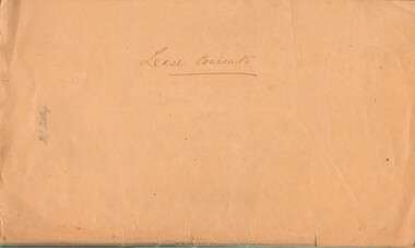
Document - MCCOLL, RANKIN AND STANISTREET COLLECTION: LEASE CONSENTS
... ... South Monument....);, 10370 Great Eastern (Bendigo), includes map; 10014, South monument; 10059 North Neanger, with map; 10072 ; 10104; North Virginia; 10068 New Don Company with Map; 10032 New Balaclava, Whroo; 10026 East Clarence Gold M/C. ...History House 11 Mackenzie Street Bendigo goldfields GOLD MINES Bendigo Gold Mines North Virginia Great Eastern South Monument North neanger New Don East Clarence New Balaclava Manilla Folder containing correspondence and consents relating to the following Gold Mining Leases; 10819, 10027 (North Virginia Gold Mining Co.);, 10370 Great Eastern (Bendigo), includes map; 10014, South monument; 10059 North Neanger, with map; 10072 ; 10104; North Virginia; 10068 New Don Company with Map; 10032 New Balaclava, Whroo; 10026 East Clarence Gold M/C. ...Manilla Folder containing correspondence and consents relating to the following Gold Mining Leases; 10819, 10027 (North Virginia Gold Mining Co.);, 10370 Great Eastern (Bendigo), includes map; 10014, South monument; 10059 North Neanger, with map; 10072 ; 10104; North Virginia; 10068 New Don Company with Map; 10032 New Balaclava, Whroo; 10026 East Clarence Gold M/C. Dated 1933 - 34gold mines, bendigo, gold mines, north virginia, great eastern, south monument, north neanger, new don, east clarence, new balaclava -
 City of Ballarat
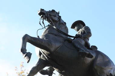
Artwork, other - Public Artwork, Boer War Memorial by James White, 1906
... ...south africa monument...The memorial is of historical and aesthetic significance to the people of Ballarat. boer war south africa monument In honour of Australian Soldiers who fought in South Africa 1899-1902. ...The Boer War Memorial was created by sculptor James White in honour of Australian Soldiers who fought in the South African War (1899-1902). White used the electrolytic copper deposit method to produce this large statue, which is sometimes mistaken for a cast bronze work. The Foundation stone was laid on 18 May 1901 by H.R.H The Duke of York (George V). The sculpture was unveiled on the 1st November 1906 by His Excellency Baron Northcote G.C.I.E., C.B. Governor General of Australia and then Mayor of Ballarat, J. J. Brokenshire. Bravery and mateship are beautifully captured in depiction of a scene taken straight from the battlegrounds. Today the memorial is a much-photographed tribute and exploration of the friendships and struggles of men at war. A proud cavalry horse bears the weight of two men in the chaos of the battlefield. The Boer War in Africa was an early example of the Australian Colonies sacrificing men and equipment for Britain to defend it’s Empire against colonial insurgence. The memorial is of historical and aesthetic significance to the people of Ballarat.Horse and figures, bronze mounted on bluestone base and granite plinth, plaques list the war dead. The artwork depicts two soldiers and a horse. A British soldier is being succoured by an Australian mounted rifleman. In honour of Australian Soldiers who fought in South Africa 1899-1902. Foundation stone laid 18th May 1901 by H.R.H The Duke of York (George V). Unveiled 1st November 1906 by His Excellency Baron Northcote G.C.I.E., C.B. Governor General of Australia. J. H. Barker Chairman. J. J. Brokenshire Mayorboer war, south africa monument -
 Melbourne Tram Museum
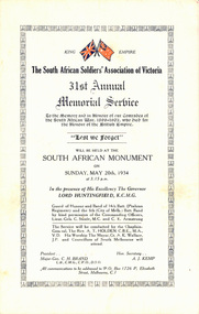
Document - Programme, "31st Annual Memorial Service", May. 1934
... The South African Soldiers' Association of Victoria 31st Annual Memorial Service held at South African Monument on Sunday May 20th 1934....Melbourne Tram Museum 8 Wallen Road Hawthorn melbourne Trams tramways Events Governors The South African Soldiers' Association of Victoria 31st Annual Memorial Service held at South African Monument on Sunday May 20th 1934. "31st Annual Memorial Service" Document Programme ...The South African Soldiers' Association of Victoria 31st Annual Memorial Service held at South African Monument on Sunday May 20th 1934.trams, tramways, events, governors -
 Bendigo Historical Society Inc.
Document - CENTRAL DEBORAH GOLD MINE: ADDITIONAL MINES ALONG THE DEBORAH LINE OF REEF
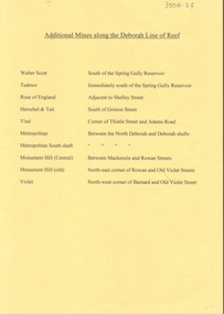
... Walter Scott, Tadmor, Rose of England, Herschel and Tait, Vital, Metropolitan, Metropolitan South shaft, Monument Hill Central, Monument Hill old, Violet. ...Walter Scott, Tadmor, Rose of England, Herschel and Tait, Vital, Metropolitan, Metropolitan South shaft, Monument Hill Central, Monument Hill old, Violet. ...BHS CollectionA4 yellow paper. List of additional mines along the Deborah reef. Walter Scott, Tadmor, Rose of England, Herschel and Tait, Vital, Metropolitan, Metropolitan South shaft, Monument Hill Central, Monument Hill old, Violet. Locations of each mine listed with name.bendigo, mining, central deborah gold mine, central deborah gold mine -
 Glenelg Shire Council Cultural Collection
Photograph - Photograph - South Portland Cemetery, n.d
... Alexander Davidson's grave, South Portland Cemetery. Granite monument with urn on top, surrounded by wrought iron fence. ...Alexander Davidson's grave, South Portland Cemetery. Granite monument with urn on top, surrounded by wrought iron fence. ...Alexander Davidson arrived in Australia in 1838 as a poor Scotsman, a mason by trade. Alexander was to work hard and amass enough savings to allow him to invest in an established Squatting Run in 1848. As stated in his obituary "by patient industry and perseverance acquired considerable wealth as a squatter on the Satima station, near Casterton" on the Wando River in Victoria. He was at first a part-owner of the Satimer Run with his brother-in-law Duncan Robertson, but was able to buy out his brother-in-law's share in 1860. In 1864, with proceeds of his squatting income, he built a two storey stucco rendered bluestone house in Portland which he called "Wando Villa", which is today a Heritage Listed Building.Black and white photo. Alexander Davidson's grave, South Portland Cemetery. Granite monument with urn on top, surrounded by wrought iron fence. Inscription unreadableBack: 'ALEXANDER DAVIDSON'S GRAVE SOUTH PORTLAND CEMETERY, PORTLAND VICTORIA 1971' - hand printed, black biro Purple stamp 'ALEX PRIESTLEY BOX 155 PHONE 309 HEYWOOD VIC 3304squatter, squattocracy -
 Bendigo Historical Society Inc.
Newspaper - JENNY FOLEY COLLECTION: LEST WE FORGET
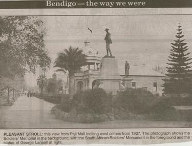
... In the foreground is the South African soldiers' monument, George Lansell statue and the Soldiers' Memorial Hall. ...In the foreground is the South African soldiers' monument, George Lansell statue and the Soldiers' Memorial Hall. ...Bendigo Advertiser ''The way we were'' from 2000. Lest we Forget: Pall Mall, Bendigo, looking west, circa 1960. In the foreground is the South African soldiers' monument, George Lansell statue and the Soldiers' Memorial Hall. The clip is in a folder.newspaper, bendigo advertiser, the way we were -
 Mission to Seafarers Victoria
Photograph - Photograph, colour, c. 2001
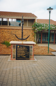
... Opened by His Excellency Sir Eric Neal AC CVO on 30 September 2001, the Memorial is located in City Park, Port Pirie, South Australia. The monument commemorates those who were lost at sea while serving with the Merchant Navy. ...Mission to Seafarers Victoria 717 Flinders Street Docklands melbourne Opened by His Excellency Sir Eric Neal AC CVO on 30 September 2001, the Memorial is located in City Park, Port Pirie, South Australia. The monument commemorates those who were lost at sea while serving with the Merchant Navy. ...Opened by His Excellency Sir Eric Neal AC CVO on 30 September 2001, the Memorial is located in City Park, Port Pirie, South Australia. The monument commemorates those who were lost at sea while serving with the Merchant Navy. Mr Noel Smith, a resident of Port Pirie, former Merchant Navy seaman and Port Pirie tugboat officer designed the memorial, found the anchor located on the top of the memorial during a dredging operation in a creek near the Nystar plant and wrote the poem inscribed on the main plaque. Front Inscription Lost Ones They live in the curl of the breaking wave, They sing when the sea winds blow, They lay not confined in a land locked grave, Nor in dim dark depths below. Do you hear them laugh in the rippling tide, Call free in the ocean breeze ? Do you see them soar where great gulls glide At peace with the fearsome seas ? They live still in the hearts of those who wait Held strong in the bonds of love 'Til their souls unite and congregate In God`s great harbour above. Noel Smith Merchant Seaman For those who were lost to the depths of the sea Emma Hindmarsh Left Side Inscription Memorial unveiled by His Excellency Sir Eric Neal AC CVO Governor of South Australia and His Worship the Mayor Ken Madigan Port Pirie Regional Council Memorial blessed and consecrated by Right Reverend Garry Weatherill Bishop of Willochra 30 September 2001Colour photograph of the memorial made of an anchor on a bricks and stones base with a black marble plaque titled The Lost Ones. The logo of the Merchant Navy, MN, on the top left corner of the plaque.merchant navy, mn, port pirie, memorial -
 Warrnambool and District Historical Society Inc.
Book, The Journals of Major-Gen. C.G. Gordon, C.B. at Kartoum (sic), 1885
... Warrnambool and District Historical Society Inc. 2 Gilles Street (south of Merri St) Warrnambool great-ocean-road This book, published in 1885, contains six books of the journal written by General Charles Gordon at Khartoum, Sudan, Africa in 1884, Gordon was killed during the siege of this town. This book is retained not only because of its antiquarian interest but also because the heroic end of General Gordon made him a household name throughout the British Empire at the time. In Warrnambool in 1886 a General Gordon monument ...Journals of General Gordon of KhartoumThis is a book of 316 pages, plus 33 pages of information on other books for sale by the publisher.The book has a dark red cover with gold lettering on the front cover and the spine. The pages contain printed text, two maps, a portrait and thirty black and white illustrations.non-fictionJournals of General Gordon of Khartoumgeneral gordon of khartoum, gordon, kartoum -
 Warrnambool and District Historical Society Inc.
Souvenir, Spoon and fork, Mid 20th century
... Warrnambool and District Historical Society Inc. 2 Gilles Street (south of Merri St) Warrnambool great-ocean-road These items are typical of souvenir items which would have been commonly purchased by visitors and locals alike.The Warrnambool war memorial is one of the city's most recognisable monuments. ...These items are typical of souvenir items which would have been commonly purchased by visitors and locals alike.The Warrnambool war memorial is one of the city's most recognisable monuments. The granite column is is 38 feet tall, and topped by the Angel of Peace.At the base is an Australian Soldier with head bowed which is carved in Italian marble. The monument is backed by a wall which has the names of 1100 soldiers from the First World War from Warrnambool and district. of whom 240 were killed. The names of WW 2 soldiers who lost their lives were added on the western section after that conflict. A common object which relates to one of Warrnambool's important landmarks..1 Spoon. .2 Fork. A silver spoon and fork both with a patterned handle with a medallion with an oval image of the Warrnambool War Memorial.It is in enamelled in colours of blue white green with outline in metal. The enamelled ovals are both surrounded by a silver scalloped rim. Both are in a red box with white text and have a clear cellulose cover. Peninsula plate EPNS A1. Soldier's memorial Warrnambool. Swann and Hudson Peninsula Plate is printed on the box.warrnambool, souvenir spoon, souvenir fork, warrnambool war memorial -
 Warrnambool and District Historical Society Inc.
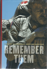
Book, Remember Them, 2009
... Warrnambool and District Historical Society Inc. 2 Gilles Street (south of Merri St) Warrnambool great-ocean-road This book gives details of the Melbourne Shrine of Remembrance, war memorials and monuments in suburbs and towns and cities around Victoria and descriptions of the lives of some Victoria war heroes of the Boer War, World Wars One and Two, the Korean War and the Vietnam War. ...This book gives details of the Melbourne Shrine of Remembrance, war memorials and monuments in suburbs and towns and cities around Victoria and descriptions of the lives of some Victoria war heroes of the Boer War, World Wars One and Two, the Korean War and the Vietnam War.This book is of some local interest as it contains information on war memorials and war heroes in Warrnambool and other district localities. It will be useful for research This is a hard cover book with a multi-coloured paper dust jacket with an image of a soldier on the front and yellow and white lettering. The book is red-coloured with white lettering on the spine. Cover – A Guide to Victoria’s Wartime Heritage – Remember Themmelbourne shrine of rememberance, war history, warrnambool -
 Warrnambool and District Historical Society Inc.
Book, Kenneth Stanley Inglis, Sacred Places War Memorials in the Australian Landscape
... south of Merri St) Warrnambool great-ocean-road This book looks at the war memorials in Australia and traces the development of the Anzac cult and the reasons that the war memorials are increasingly cherished in Australian society. It is an important treatise on a unique aspect of Australia cultural life. The book has relevance to all Australians as an exploration of an important aspect of our lives today. It is of some relevance specifically to Warrnambool as there are several references to the Warrnambool War Memorial war memorials in australia monuments ...This book looks at the war memorials in Australia and traces the development of the Anzac cult and the reasons that the war memorials are increasingly cherished in Australian society. It is an important treatise on a unique aspect of Australia cultural life.This is a paperback book of 521 pages. The cover is multi-coloured with an image of an Australian soldier on the front and spine.non-fictionThis book looks at the war memorials in Australia and traces the development of the Anzac cult and the reasons that the war memorials are increasingly cherished in Australian society. It is an important treatise on a unique aspect of Australia cultural life.war memorials in australia, monuments -
Federation University Historical Collection
Booklet - Walking Guide, Ballarat Heritage Walking Guide, c2015
... Monument...Sturt Street...unicorn hotel...Ballarat Town hall...Sugg light...Ballarat Post Office...Camp Street...Summerscales Building...State Offices...Police court...Huyghue House...Pratt's Building...YMCA...Ballarat Trades Hall...ANA Hall...maps...Lydiard Street...Ballarat Gaol...Ballarat School of Mines...Wesleyan Church...Ansonia...Lynn's Chambers...Craig's Royal Hotel...her Majesty's Theatre...Union Bank Building...Bank of Australasia...National Bank...Colonial Bank of Australasia...Bank of New South...Barker Library (top floor) Mount Helen goldfields Ballarat Walking trail Statues Gold Monument Sturt Street unicorn hotel Ballarat Town hall Sugg light Ballarat Post Office Camp Street Summerscales Building State Offices Police court Huyghue House Pratt's Building YMCA Ballarat Trades Hall ANA Hall maps Lydiard Street Ballarat Gaol Ballarat School of Mines Wesleyan Church Ansonia Lynn's Chambers Craig's Royal Hotel her Majesty's Theatre Union Bank Building Bank of Australasia National Bank Colonial Bank of Australasia Bank of New South Wales George Hotel Old Colonists' hall Art Gallery of Ballarat Union Fidelity Hall Goller's Warehouse Dunn's Warehouse Ludbrook House Reid's Coffe Police Ballarat Railway Station Cenotaph Queen Victoria Fountain Boer War Memorial Burke and Wills Founitain Titanic Memorial Bandstand 35 page booklet with a detail from the Mining Exchange on the front. ...35 page booklet with a detail from the Mining Exchange on the front. ballarat, walking trail, statues, gold monument, sturt street, unicorn hotel, ballarat town hall, sugg light, ballarat post office, camp street, summerscales building, state offices, police court, huyghue house, pratt's building, ymca, ballarat trades hall, ana hall, maps, lydiard street, ballarat gaol, ballarat school of mines, wesleyan church, ansonia, lynn's chambers, craig's royal hotel, her majesty's theatre, union bank building, bank of australasia, national bank, colonial bank of australasia, bank of new south wales, george hotel, old colonists' hall, art gallery of ballarat, union fidelity hall, goller's warehouse, dunn's warehouse, ludbrook house, reid's coffe police, ballarat railway station, cenotaph, queen victoria fountain, boer war memorial, burke and wills founitain, titanic memorial bandstand -
 Glen Eira Historical Society
Letter - Rosstown Railway
... South Calder G.K. Calder G. Hawthorn Road Glen Eira Road Ballantyne R. Office Workers CAULFIELD CONTACT Norman Peter Groups Glen Huntly Koornang Road Mills Sugar Mills Caulfield Historical Society Caulfield City Council Caulfield Town Hall Official Buildings Glen Huntly Neville Street Fourteen Parliamentary Representatives Rosstown Rosstown Railway Rosstown Railway Centenary Festivals and Celebrations Centenaries Historical Markers Plaques Monuments and Memorials Ross Murray Railways Land Transport Curraweena Road Parts of Buildings or Structures Bluestone Structures Construction Materials Caulfield Community Liaison Officer Harry Carol Currency Finances Onley Peter Elsternwick Oakleigh Council Meetings Caulfield Council Chambers Caulfield Municipal Chambers Caulfield Municipal Offices Craig A. ...This file contains two items: 1/A group of eight letters, predominantly between Hon. Secretary of Caulfield Historical Society R. Ballantyne and members of the Caulfield City Council written between 1981 and 1983, regarding the installation of a plaque in commemoration of the centenary of the Rosstown Railway. The first two letters are handwritten from R. Ballantyne to G. Calder and Carol Camy, dated 01/06/1981 and 22/02/1982. The letter to G. Calder supports a suggestion in the May edition of the CAULFIELD CONTACT for the installation of a plaque in celebration of the centenary of the Rosstown Railway, suggesting a potential site for another plaque on Curraweena Road. The letter to Carol Harry discusses the costing of the plague and a possible contribution towards this cost from the Caulfield Historical Society. The letter appears to be incomplete, having no sign off from the author. Attached to the letter is what appears to be a suggestion for the inscription of the plaque. The letters addressed to R. Ballantyne are typed and dated 12/06/1981, 24/06/1981, 14/07/19891, 17/12/1981 and 08/09/1983, from A. Craig and D.B. Hogan on behalf of City Manager G.K. Calder and City Liason Officer Carol Harry. All letters concern the commemorative plaque, with these from Carol Harry including handwritten notes which appear to be in R. Ballantyne’s handwriting. The final letter is from Mayoral Secretary Norma Polglase to Miss B. Snowball, dated 23/08/1983, inviting her to attend the unveiling of the plaque. Also included in the item are Council Committee Meeting minutes, dated 16/05/1981, broaching the subject of installing the plaque in Koornang Road. 2/Four colour photographs and two black and white copies of one of the photographs, all dated 18/09/1983 and showing the opening of the commemorative plaque in Marrara Gardens. Two photographs picture Mayor Brian Rudski and City Manager Graham Calder with a crowd of unidentified people present. One photograph and both copies are of the inscription on the plaque, with the wording identical to that of the handwritten note by R. Ballantyne, in item one.caulfield, caulfield south, calder g.k., calder g., hawthorn road, glen eira road, ballantyne r., office workers, caulfield contact, norman peter, groups, glen huntly, koornang road, mills, sugar mills, caulfield historical society, caulfield city council, caulfield town hall, official buildings, glen huntly neville street fourteen, parliamentary representatives, rosstown, rosstown railway, rosstown railway centenary, festivals and celebrations, centenaries, historical markers, plaques, monuments and memorials, ross murray, railways, land transport, curraweena road, parts of buildings or structures, bluestone structures, construction materials, caulfield community liaison officer, harry carol, currency, finances, onley peter, elsternwick, oakleigh, council meetings, caulfield council chambers, caulfield municipal chambers, caulfield municipal offices, craig a., caulfield city manager, city of caulfield, caulfield physical environment committee, public meetings, meetings, ross james, hogan o.b., arrow engraving, campbell f., snowball miss., elsternwick gladstone parade nineteen, walters w.r., marara road gardens, marara road, marara gardens, narrawong road, ceremonies, caulfield mayors, polglase norma, mayoral secretaries, railways routes, documents, correspondence, rudski brian, calder graham, events and activities, official buildings, insignia, local government, local officials and employees, parks and reserves, buildings structures and establishments, official events, festivals and celebrations, occupations, political processes, local history, history, financial economics, local government finance -
Glen Eira Historical Society
Document - Memorials in Glen Eira
... Monument to Racehorse ‘Jackstaff’... Ross Murray... Browne Thomas Alexander... Thomas Alexander Browne Grave... Brighton Cemetery... Rolf Boldrewood... North Road... Caulfield South...Historical Markers Caulfield City Caulfield Grammar School Elsternwick Regent Street Caulfield Racing Museum Rosstown Railway Marker Caulfield Bambra Road Curraweena Road Marara Road City of Caulfield Mayors Councillors Caulfield Historical Society Rosstown Railway Caulfield Grammar School Pavement Marker Monument to Racehorse ‘Jackstaff’ Ross Murray Browne Thomas Alexander Thomas Alexander Browne Grave Brighton Cemetery Rolf Boldrewood North Road Caulfield South Browne Margaret Maria Grave of Sir John and Lady Monash Monash John Sir Monash Hannah Victoria Lady Frederick Jowett Memorial Drinking Fountain Caulfield Town Hall Hawthorn Road Glen Eira Road Jowett Frederick Borough of Caulfield Adam Lindsay Gordon Grave Gordon Adam Lindsay Gordon Annie Lindsay Jewish Victims of World War 2 Memorial Kadimah Jewish Cultural Centre and Library Selwyn Street Burston Seddon Hopetoun Gardens Cannon Glenhuntly Road Glen Huntly Road Schools Historic Sites Plaques Footpaths Horseracing Horses Jackstaff Monuments and Memorials Railways Authors Cemeteries Graves Gravestones Jewish Community Town Clerks Shire Secretaries Town Hall Drinking Taps Poetry Children Libraries World War 1939 – 1945 Hopetoun Cannons Festivals and Celebrations Document Memorials in Glen Eira ...This file contains one item: 1/A printout from the Victorian Memorials Database, undated and researcher unknown, containing records of 9 memorials in the Caulfield City municipality. These memorials are: - Caulfield Grammar School Site Pavement Marker, Elsternwick - Monument to racehorse ‘Jackstaff’ in Caulfield Racing Museum. - Rosstown Railway Marker, Bambra Road, Caulfield. - Thomas Alexander Browne Grave, Brighton Cemetery. - Grave of Sir John and Lady Monash, Brighton Cemetery. - Frederick Jowett Memorial Drinking Fountain, Caulfield Town Hall - Adam Lindsay Gordon Grave, Brighton Cemetery. - Jewish victims of World War 2 Memorial, Kadimah Centre, Elsternwick. - Hopetown Gardens Cannon, Elsternwick.historical markers, caulfield city, caulfield grammar school, elsternwick, regent street, caulfield racing museum, rosstown railway marker, caulfield, bambra road, curraweena road, marara road, city of caulfield, mayors, councillors, caulfield historical society, rosstown railway, caulfield grammar school pavement marker, monument to racehorse ‘jackstaff’, ross murray, browne thomas alexander, thomas alexander browne grave, brighton cemetery, rolf boldrewood, north road, caulfield south, browne margaret maria, grave of sir john and lady monash, monash john sir, monash hannah victoria lady, frederick jowett memorial drinking fountain, caulfield town hall, hawthorn road, glen eira road, jowett frederick, borough of caulfield, adam lindsay gordon grave, gordon adam lindsay, gordon annie lindsay, jewish victims of world war 2 memorial, kadimah jewish cultural centre and library, selwyn street, burston seddon, hopetoun gardens cannon, glenhuntly road, glen huntly road, schools, historic sites, plaques, footpaths, horseracing, horses, jackstaff, monuments and memorials, railways, authors, cemeteries, graves, gravestones, jewish community, town clerks, shire secretaries, town hall, drinking taps, poetry, children, libraries, world war 1939 – 1945, hopetoun, cannons, festivals and celebrations -
Glen Eira Historical Society
Document - Brighton Cemetery, North Road, Caulfield South
... Miller Mausoleum Brighton Cemetery Caulfield South North Road Ward Andrew Miller Septimus Miller Clara Johnstone Miller Gwendoline Stewart Cantala Dandenong Road Cemeteries Graves Tombstones Gravestones Monuments and memorials Architectural styles Gothic (revival) architecture Architectural features Gables Roofs Windows Document Brighton Cemetery, North Road, Caulfield South ...Photocopy of the entry in the Caulfield Conservation Study, dated 01/1995, by Andrew Ward for the Miller Mausoleum at Brighton Cemetery. The study includes a description of the tomb’s architectural features, a brief history and a photograph of the tomb.miller mausoleum, brighton cemetery, caulfield south, north road, ward andrew, miller septimus, miller clara johnstone, miller gwendoline stewart, cantala, dandenong road, cemeteries, graves, tombstones, gravestones, monuments and memorials, architectural styles, gothic (revival) architecture, architectural features, gables, roofs, windows -
Glen Eira Historical Society
Article - Brighton Cemetery, North Road, Caulfield South
... Brighton Cemetery Caulfield South Buckley Maurice Joynt William Donovan Newland James Ernest Peeler Walter Graves Cemetries Medals War Veterans Monuments and Memorials War Memorials World War 1914-1918 World War 1939-1945 Johnson Jack Alexander Caulfield Military Hospital Hospitals Johnson Carl Johnson Bill Historical Markers Article Brighton Cemetery, North Road, Caulfield South ...This file contains two items about war graves. 1/A two-page newspaper article from the "Herald Sun" of 31/07/2011 concerning the neglected state of the graves of some Victoria Cross winners and other war heroes at several cemeteries in Melbourne including Brighton Cemetry. The article notes that the Dept of Veterans' Affairs and other authorities are not adequately maintaining the graves. Includes photographs. 2/A newspaper article from Glen Eira/Port Phillip Leader dated 12/02/2013. The article makes mention that a Gallipoli soldier will finally receive an official war grave and commemorative service in April 2013. Local war historian Carl Johnson stepped in to help and the Australian War Graves will install a grave marker to Pte. Jack Alexander Johnson.brighton cemetery, caulfield south, buckley maurice, joynt william donovan, newland james ernest, peeler walter, graves, cemetries, medals, war veterans, monuments and memorials, war memorials, world war 1914-1918 world war 1939-1945, johnson jack alexander, caulfield military hospital, hospitals, johnson carl, johnson bill, historical markers -
 Glen Eira Historical Society
Caulfield Properties
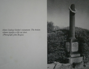
... Glen Eira Historical Society 965 Glen Huntly Rd Caulfield VIC 3162 melbourne Caulfield South North Road Hawthorn Road Brighton Cemetery Cemeteries Gordon Adam Lindsay Monuments Photograph of Adam Lindsay Gordon’s monument in Brighton Cemetery, date unknown Caulfield Properties ...Photograph of Adam Lindsay Gordon’s monument in Brighton Cemetery, date unknowncaulfield south, north road, hawthorn road, brighton cemetery, cemeteries, gordon, adam lindsay, monuments -
Glen Eira Historical Society
Article - Watts, William Cowley
... The house was named after the ship Glen Huntly which travelled from Scotland to Port Phillip Bay arriving 7 April 1840 2/ Research notes (2 pages) on the Watts family of Caulfield being one line of info (likely from rate books but unsourced and undated) giving 1874 details of a property in Orrong Road for William Cowley Watts on one page; plus a separate page with one line of information (unsourced and undated) giving 1910 Directory information for James S Watts architect at "Whybe" Murray St E. south side. 3/ An A4 typed article about William Cowley Watts which is similar but not the same as the Caulfield Contact article above. 4/ A photocopy combining a photo of a head and shoulders portrait of a man with handwritten notes identifying him as William Cowley Watts (1839-1883), Shire President of Caulfield, City Surveyor of Melbourne. Watts William Cowley Watts Thomas Henry Shire president Councillors Caulfield Monuments ...This file contains four items about William Cowley Watts, brother of Thomas Henry Watts:. 1/ Photocopy of two articles from newspapers on one page. One entitled "Portait for the Mayoral Gallery" (Caulfield Contact 01/09/1988) relates to a portrait of William Cowley Watts, who was the Shire President of Caulfield in 1876 and 1883, being added to Council's memorial gallery of Mayors. The other entitled "GLENHUNTLY-steeped in history" (Southern Cross 18/06/1986) states that the history of the suburb Glenhuntly is derived from the house Glen Huntly built in 1855 as the home of Thomas Watts. It was the first architect designed house in Caulfield. A black and white photograph of the house with Thomas Watts' family is included in the Southern Cross article. The house was named after the ship Glen Huntly which travelled from Scotland to Port Phillip Bay arriving 7 April 1840 2/ Research notes (2 pages) on the Watts family of Caulfield being one line of info (likely from rate books but unsourced and undated) giving 1874 details of a property in Orrong Road for William Cowley Watts on one page; plus a separate page with one line of information (unsourced and undated) giving 1910 Directory information for James S Watts architect at "Whybe" Murray St E. south side. 3/ An A4 typed article about William Cowley Watts which is similar but not the same as the Caulfield Contact article above. 4/ A photocopy combining a photo of a head and shoulders portrait of a man with handwritten notes identifying him as William Cowley Watts (1839-1883), Shire President of Caulfield, City Surveyor of Melbourne.watts william cowley, watts thomas henry, shire president, councillors, caulfield, monuments, memorials, portrait, gallery of mayors, city offices, architects, architecture, national trust, victorian institute of architects, city surveyor of melbourne, drainage system, watts charles george, caulfield grammar school, fellow of the federal institute of accountants, city treasurer of melbourne, watts geoffrey, glen huntly, glenhuntly, glenhuntly traders association, caulfield city council, huntly street, grange road, glenhuntly road, watts john, watts mary, thos. h. watts and sons, shire of caulfield, drainage, irrigation sewerage, sanitation, land surveys, royal society, mansion, retail trade, merchants, station place, watts james s, murray street, "whybe" -
 Bendigo Historical Society Inc.
Document - LONG GULLY HISTORY GROUP COLLECTION: CORNISH ASSOCIATION NEWSLETTER JUNE 2003 - PRESIDENTS REPORT
... Monument... John Bolitho... Cr Darrel McClure... Long Gully History Group... Carol Rasmussen... Long Gully Community fHouse... Gwen Phillips... Vivian Pryor... Kaangaroo Sports Club... Evelyn Butfield... Jean Shadforth... Tom Luke... Cornish Association of South...History House 11 Mackenzie Street Bendigo goldfields BENDIGO History long gully history group The Long Gully History Group - Cornish Association Newsletter June 2003 - Presidents Report Cornish Association of Bendigo & District Inc George A Ellis Eaglehawk Fire Station Long Gully Mining Monument John Bolitho Cr Darrel McClure Long Gully History Group Carol Rasmussen Long Gully Community fHouse Gwen Phillips Vivian Pryor Kaangaroo Sports Club Evelyn Butfield Jean Shadforth Tom Luke Cornish Association of South Australia Leanne and Robert Lloyd Cornish Association Newsletter Volume 9, Number 2, June 2003 mentions the unveiling of the Long Gully Mining Monument on May 25th. ...Cornish Association Newsletter Volume 9, Number 2, June 2003 mentions the unveiling of the Long Gully Mining Monument on May 25th. The unveiling was carried out by John Bolitho Grand Bard of Cornwall in conjunction with Cr Darrel McClure. The ceremony was followed by afternoon tea supplied by the Long Gully History Group and organised by Carol Rasmussen of the Long Gully Community House. Some special guests were Gwen Phillips president of the C.A.V. and Vivian Pryor from Newquay Cornwall. The day was finished by Annual Dinner held at the Kangaroo Sports Club. Plans for other celebrations were underway. A paper, the Cornish in the First World War, was presented by Tom Luke at the Cornish association of South Australia's seminar. Leanne and Robert Lloyd had to come home as their house was considerably damaged by a tornado that swept through Eaglehawkbendigo, history, long gully history group, the long gully history group - cornish association newsletter june 2003 - presidents report, cornish association of bendigo & district inc, george a ellis, eaglehawk fire station, long gully mining monument, john bolitho, cr darrel mcclure, long gully history group, carol rasmussen, long gully community fhouse, gwen phillips, vivian pryor, kaangaroo sports club, evelyn butfield, jean shadforth, tom luke, cornish association of south australia, leanne and robert lloyd -
 Bendigo Historical Society Inc.
Document - MCCOLL, RANKIN AND STANISTREET COLLECTION: NOTES RE GOVERNMENT GAZETTES AND LIST OF PLANT
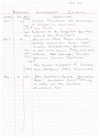
... Includes Chinese regulations for management of Chinese on Gold fields (1856) , Chinamans Flat Steam Engine company (1857), two Chinese murdered at Clinkers Hill, Castlemaine (1862) Charles Chromley Dowling appointed Chinese Protector (1857), John Chatfield Tyler Immigration agent, to carry out the Chinese Emigrations Act (1861) Back page dated 1947 lists "stocktake list of plant" On list - Deborah United 1946; North Hustlers; New Monument GMC, North Virginia, South Wattle Gully, Central Napoleon, Red, White and Blue Extended, Deborah Extended, New Don, East Clarence, Napoleon Reef, New Monument Battery, Deborah Extended. ...Includes Chinese regulations for management of Chinese on Gold fields (1856) , Chinamans Flat Steam Engine company (1857), two Chinese murdered at Clinkers Hill, Castlemaine (1862) Charles Chromley Dowling appointed Chinese Protector (1857), John Chatfield Tyler Immigration agent, to carry out the Chinese Emigrations Act (1861) Back page dated 1947 lists "stocktake list of plant" On list - Deborah United 1946; North Hustlers; New Monument GMC, North Virginia, South Wattle Gully, Central Napoleon, Red, White and Blue Extended, Deborah Extended, New Don, East Clarence, Napoleon Reef, New Monument Battery, Deborah Extended. ...Two page, handwritten document on lined paper - front page reference to Victorian Government Gazettes and Chinese regulations, where listed in the gazettes and dates. Includes Chinese regulations for management of Chinese on Gold fields (1856) , Chinamans Flat Steam Engine company (1857), two Chinese murdered at Clinkers Hill, Castlemaine (1862) Charles Chromley Dowling appointed Chinese Protector (1857), John Chatfield Tyler Immigration agent, to carry out the Chinese Emigrations Act (1861) Back page dated 1947 lists "stocktake list of plant" On list - Deborah United 1946; North Hustlers; New Monument GMC, North Virginia, South Wattle Gully, Central Napoleon, Red, White and Blue Extended, Deborah Extended, New Don, East Clarence, Napoleon Reef, New Monument Battery, Deborah Extended. Possibly written by Albert Richardson.bendigo, mining, mccoll rankin & stanistreet -
 Bendigo Historical Society Inc.
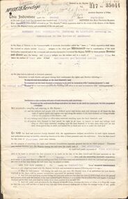
Document - MCCOLL, RANKIN AND STANISTREET COLLECTION: INDENTURE BETWEEN KING EDWARD VIII AND MONUMENT HILL CONSOLIDATED MINE, 2/09/1936
... Common seal of Monument Hill Consolidated... Nell Gwynne Mine... South...History House 11 Mackenzie Street Bendigo goldfields BENDIGO Mining Monument Hill Consolidated Common seal of Monument Hill Consolidated Nell Gwynne Mine South Nell Gwynne Gold Mining Company Bendigo Mine Ophir Street Rowan Street Mackenzie Street.Indenture Vol 317 Fol. 35044. ...Indenture document number 10878, Vol 317 Folio 35044. Foolscap 4 pages including a map, dated 2nd September, 1936, between King Edward VIII (Crown land) and Monument Hill Consolidated (Bendigo) No Liability 'carrying on operations in the Parish of Sandhurst, to occupy and use the land demised as a site for machinery buildings and offices to be used in connexion with 'mining purposes' ' Document signed by Right Hon William Charles Arcedeckne, (Baron Huntingfield) and J. Stanistreet, Manager, affixed with the Common Seal of Monument Hill Consolidated (Bendigo) No Liability. Map drawn on dark buff paper, and fixed to document. Map shows lease 10878 in the Mining District of Bendigo, Parish of Sandhurst, County of Bendigo. N.Area 2.2.24 ( 2 acres, 2 roods, 24 perches ) Lease site on Rowan Street, bordered by Ophir Street. Coloured in purple on plan with small red area. On bottom: ' Note Red Areas Excised. Scale 4 chains to 1 inch, M.M. Var. 8 degrees 32' E. On lease site, New Chum Gully marked, W.B. House, and Permanent Occy. marked on red area. On last page ownership of lease details from 1937 to 1942.bendigo, mining, monument hill consolidated, common seal of monument hill consolidated, nell gwynne mine, south nell gwynne gold mining company, bendigo mine, ophir street, rowan street, mackenzie street.indenture vol 317 fol. 35044. j stanistreet. -
 The Beechworth Burke Museum
Photograph
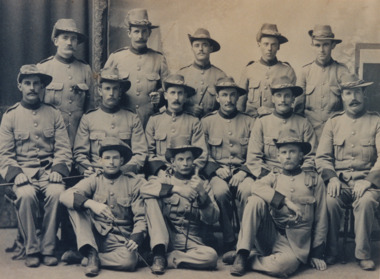
... South Africa. The photograph is historically significant due to its connection to the Second Boer War and Australian Light Horse Regiment. This significance is enhanced by Australia's involvement in this war, specifically of the Victorian Mounted Rifles. This unit retains a special significance within Victorian culture, as there is a memorial and monument ...It is believed that the photograph was taken between 1899 - 1903. Depicted is a group of fourteen unidentified young men dressed in Australian military uniforms. A few of them are holding swords. This group were part of the Beechworth Mounted Rifles; a voluntary detachment of the Australian Light Horse Militia. This unit consisted of soldiers from the Euroa, Longwood, Violet Town, Benalla, Thoona, Wangaratta, Rutherglen, and Beechworth Detachments of Victorian Rifles, and subsequently formed into the 8th Australian Light Horse Regiment (Victorian Mounted Rifles). The Victorian Mounted Rifles was gazetted as a volunteer formation on 2 December 1885 with the aim of consolidating all the disparate calvary units dispersed across Victoria into a coordinated and single administrative and military unit. Two contingents of the Victorian Mounted Rifles fought during the Second Boer War (11 October 1889 - 31 May 1902). This conflict was fought between the British Empire and two independent Boer states; the South African Republic and the Orange Free State, over the Empire's influence in South Africa.The photograph is historically significant due to its connection to the Second Boer War and Australian Light Horse Regiment. This significance is enhanced by Australia's involvement in this war, specifically of the Victorian Mounted Rifles. This unit retains a special significance within Victorian culture, as there is a memorial and monument - erected in 1903 - honouring their service on St. Kilda Road in Melbourne. The record has strong research potential. This is due to the ongoing scholarly and public interest in war, military history, and the ANZAC legend. The historic context of this record can provide insight into Australia's history, military and defence policies. Lastly, as the Victorian Mounted Rifles remain a largely unexplored topic in comparison to other military units and divisions, the record presents a unique opportunity for further and important study and research.Sepia rectangular photograph printed on matte photographic paper.Reverse: BMM2638 / 071 1NA211 22JAN98 FOTOSUPPLIES........ ........................................ /military album, beechworth mounted rifles, australian light horse militia, second boer war, victorian mounted rifles, australian light horse regiment, military, war, british empire, south africa, 1800s, 1900s, australian army -
 Eltham District Historical Society Inc
Photograph, Hume and Hovell passed here at Seymour 28 Oct 1824, Spring Excursion, Hume and Hovell's 1824 expedition (Part 2), 26 October 1997, 26/10/1997
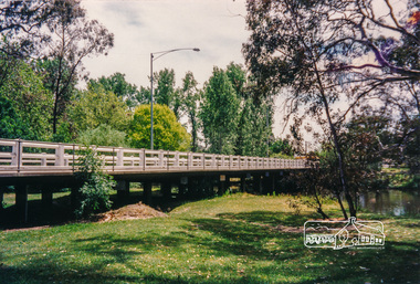
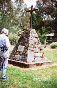
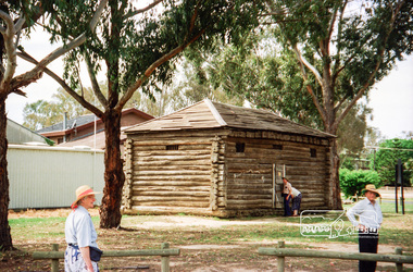
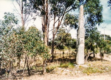
... The Swanpool monument states that they passed four miles south and returned three miles north. ...The Swanpool monument states that they passed four miles south and returned three miles north. ...[article by Diana Bassett-Smith in EDHS Newsletter No. 117, November 1997:] MONUMENT HUNTING THE HUME AND HOVELL WAY - Sunday October 26 1997 dawned bright and very warm. Some twenty-five members, complete with picnic baskets, met outside the Eltham Library awaiting the Cobb and Co. large coach which would be taking us on the second leg of our travels along the route of the early explorers Hume and Hovell. Stephen West was our very good driver for the day. He would be guided around the circuitous route by Russell Yeoman who had made a detailed study, not only of the intended route, but of the story of these two explorers. During the trip Russell regaled us with poetry, quotations from the Journals and the History of the Shire of Seymour, "The New Crossing Place" by Martindale, 1982, (now Mitchell Shire due to the recent amalgamations). We headed towards the Hume Highway via Greensborough and Cooper Street and proceeded north to our first stop, noting on the way Monument Hill in the distance which is near Kilmore and, according to Russell, well worth the effort to visit as the view across the valley is magnificent. Past Sunday Creek Valley, Mt Piper and Mt Disappointment, all traversed and noted and named by them. We passed through Tallarook, then onto Seymour where we took photos of the monument telling us that Hume and Hovell had passed through on the 28th of October 1824. We also deviated down Hume and Hovell Road viewing deer and emu farming and the Bellbourie property now a sanctuary. Leaving Seymour behind we travelled up the Avenel Road to the Avenel monument, pyramidal in design of four reducing square blocks with a sharply pointed peak, erected in 1924 in memory of the 1824 exploration. The day was warming up and the countryside showing the dryness of the current drought. A parallel note had been made in their journal too of 1824 of the drought appearance of the country they were traversing. At Seven Creeks, Euroa we stopped for some minutes to check the monument placed 20th November 1924 to commemorate their passage on the 29th December 1824. More photos. Russell had pointed out the abrupt termination of the distant ranges which is noted in their journal. The next monument is beside the road at the entrance to Honey Suckle Creek Caravan Park, Violet Town. The squarish shaped monument some eight feet high is topped with a simple steel cross, and was to mark the date of 28th December 1824 and built for the 20th November 1924. By now it was 12.20 and nearly lunchtime as we drove along the Warranbayne Road to Roach's Road, monument hunting without success. Though there is a large, what appears to be an old timber sign which was hard to read, maybe this was the lost monument. In many of the paddocks hay had been cut and baled or was being cut, what a contrast to the rugged country they had passed through which was smoky from the fires of the natives burning off. By 1.00 pm we were at Benalla and pulled up beside the park where abundant beds of roses filled the air with their scent and the smell of barbecued food twitched the nostrils whilst the cheerful sounds of other picnickers could be heard throughout the park. We left the bus and collected up our picnics, dispersed to the various tables and enjoyed the shade from the various European trees. 2.00 pm and we were on the road again driving along the Benalla, Mansfield, Yea road. The Swanpool monument states that they passed four miles south and returned three miles north. Then we stopped at the Barjarg monument which notes that they camped near this spot. It is again a pyramidal monument and this time topped with a steel arrow indicating their route of the 29th November 1824. Half an hour later we came to another monument, again with a steel arrow marker on top and the plaque dated the 2nd of 12th 1824. Erected on the 12th of 12th 1924. "They blazed the way that we might inherit the land." Another square based and needle topped monument appeared at Yarck near Yea and this plaque records the date of 3 December 1824. Near McGuigans Road Russell related that the expedition had lost a dog but it had found them next day, the dog was apparently torn by a kangaroo. A short while later Russell reminded us here of the problems they encountered in crossing the Goulburn River near Molesworth where banks were high, water deep and wide. "Good coat of grass but quite dry due to drought". At Yea we stopped for afternoon tea and raided the last of our picnics and looked at the monument to their journey of 1824, situated at a corner of the gardens near the bowling green. No photo – we were out of film. We returned home via Kinglake West and Whittlesea past the Yan Yean Reservoir, not full. 5.00 pm back at Eltham we emptied out of the bus and everyone, including Joan Cole, collected their things, Joan also had the major souvenir of the day, a large carp she had picked up from the river bank, her cat was in for a great feast. The day was made so interesting by the informed commentary which Russell provided. His background knowledge of the route and nature of the journey could only have come from many hours of reading and driving the area. Thank you to Russell and to everyone who made the day so informative and pleasurable. Colour photographactivities, hume and hovell, monument, seymour -
 Eltham District Historical Society Inc
Photograph, Spring Excursion, Hume and Hovell's 1824 expedition (Part 2), 26 October 1997, 26/10/1997
... The Swanpool monument states that they passed four miles south and returned three miles north. ...The Swanpool monument states that they passed four miles south and returned three miles north. ...[article by Diana Bassett-Smith in EDHS Newsletter No. 117, November 1997:] MONUMENT HUNTING THE HUME AND HOVELL WAY - Sunday October 26 1997 dawned bright and very warm. Some twenty-five members, complete with picnic baskets, met outside the Eltham Library awaiting the Cobb and Co. large coach which would be taking us on the second leg of our travels along the route of the early explorers Hume and Hovell. Stephen West was our very good driver for the day. He would be guided around the circuitous route by Russell Yeoman who had made a detailed study, not only of the intended route, but of the story of these two explorers. During the trip Russell regaled us with poetry, quotations from the Journals and the History of the Shire of Seymour, "The New Crossing Place" by Martindale, 1982, (now Mitchell Shire due to the recent amalgamations). We headed towards the Hume Highway via Greensborough and Cooper Street and proceeded north to our first stop, noting on the way Monument Hill in the distance which is near Kilmore and, according to Russell, well worth the effort to visit as the view across the valley is magnificent. Past Sunday Creek Valley, Mt Piper and Mt Disappointment, all traversed and noted and named by them. We passed through Tallarook, then onto Seymour where we took photos of the monument telling us that Hume and Hovell had passed through on the 28th of October 1824. We also deviated down Hume and Hovell Road viewing deer and emu farming and the Bellbourie property now a sanctuary. Leaving Seymour behind we travelled up the Avenel Road to the Avenel monument, pyramidal in design of four reducing square blocks with a sharply pointed peak, erected in 1924 in memory of the 1824 exploration. The day was warming up and the countryside showing the dryness of the current drought. A parallel note had been made in their journal too of 1824 of the drought appearance of the country they were traversing. At Seven Creeks, Euroa we stopped for some minutes to check the monument placed 20th November 1924 to commemorate their passage on the 29th December 1824. More photos. Russell had pointed out the abrupt termination of the distant ranges which is noted in their journal. The next monument is beside the road at the entrance to Honey Suckle Creek Caravan Park, Violet Town. The squarish shaped monument some eight feet high is topped with a simple steel cross, and was to mark the date of 28th December 1824 and built for the 20th November 1924. By now it was 12.20 and nearly lunchtime as we drove along the Warranbayne Road to Roach's Road, monument hunting without success. Though there is a large, what appears to be an old timber sign which was hard to read, maybe this was the lost monument. In many of the paddocks hay had been cut and baled or was being cut, what a contrast to the rugged country they had passed through which was smoky from the fires of the natives burning off. By 1.00 pm we were at Benalla and pulled up beside the park where abundant beds of roses filled the air with their scent and the smell of barbecued food twitched the nostrils whilst the cheerful sounds of other picnickers could be heard throughout the park. We left the bus and collected up our picnics, dispersed to the various tables and enjoyed the shade from the various European trees. 2.00 pm and we were on the road again driving along the Benalla, Mansfield, Yea road. The Swanpool monument states that they passed four miles south and returned three miles north. Then we stopped at the Barjarg monument which notes that they camped near this spot. It is again a pyramidal monument and this time topped with a steel arrow indicating their route of the 29th November 1824. Half an hour later we came to another monument, again with a steel arrow marker on top and the plaque dated the 2nd of 12th 1824. Erected on the 12th of 12th 1924. "They blazed the way that we might inherit the land." Another square based and needle topped monument appeared at Yarck near Yea and this plaque records the date of 3 December 1824. Near McGuigans Road Russell related that the expedition had lost a dog but it had found them next day, the dog was apparently torn by a kangaroo. A short while later Russell reminded us here of the problems they encountered in crossing the Goulburn River near Molesworth where banks were high, water deep and wide. "Good coat of grass but quite dry due to drought". At Yea we stopped for afternoon tea and raided the last of our picnics and looked at the monument to their journey of 1824, situated at a corner of the gardens near the bowling green. No photo – we were out of film. We returned home via Kinglake West and Whittlesea past the Yan Yean Reservoir, not full. 5.00 pm back at Eltham we emptied out of the bus and everyone, including Joan Cole, collected their things, Joan also had the major souvenir of the day, a large carp she had picked up from the river bank, her cat was in for a great feast. The day was made so interesting by the informed commentary which Russell provided. His background knowledge of the route and nature of the journey could only have come from many hours of reading and driving the area. Thank you to Russell and to everyone who made the day so informative and pleasurable. Colour photographactivities, hume and hovell, bridge -
 Eltham District Historical Society Inc
Photograph, Spring Excursion, Hume and Hovell bus tour Stage 2, Seymour, Benalla; 26 Oct 1997, 26/10/1997
... The Swanpool monument states that they passed four miles south and returned three miles north. ...The Swanpool monument states that they passed four miles south and returned three miles north. ...MONUMENT HUNTING THE HUME AND HOVELL WAY (Newsletter No. 117, November 1997, by Diana Bassett-Smith) Sunday October 26 1997 dawned bright and very warm. Some twenty-five members, complete with picnic baskets, met outside the Eltham Library awaiting the Cobb and Co. large coach which would be taking us on the second leg of our travels along the route of the early explorers Hume and Hovell. Stephen West was our very good driver for the day. He would be guided around the circuitous route by Russell Yeoman wh9 had made a detailed study, not only of the intended route, but of the story of these two explorers. During the trip Russell regaled us with poetry, quotations from the Journals and the History of the Shire of Seymour, "The New Crossing Place: by Martindale, 1982, (now Mitchell Shire due to the recent amalgamations). We headed towards the Hume Highway via Greensborough and Cooper Street and proceeded north to our first stop, noting on the way Monument Hill in the distance which is near Kilmore and, according to Russell, well worth the effort to visit as the view across the valley is magnificent. Past Sunday Creek Valley, Mt Piper and Mt Disappointment, all traversed and noted and named by them. We passed through Tallarook, then onto Seymour where we took photos of the monument telling us that Hume and Hovell had passed through on the 28th of October 1824. We also deviated down Hume and Hovell Road viewing deer and emu farming and the Bellbourie property now a sanctuary. Leaving Seymour behind we travelled up the Avenel Road to the Avenel monument, pyramidal in design of four reducing square blocks with a sharply pointed peak, erected in 1924 in memory of the 1824 exploration. The day was warming up and the countryside showing the dryness of the current drought. A parallel note had been made in their journal too of 1824 of the drought appearance of the country they were traversing. At Seven Creeks, Euroa we stopped for some minutes to check the monument placed 20th November 1924 to commemorate their passage on the 29th December 1824. More photos. Russell had pointed out the abrupt termination of the distant ranges which is noted in their journal. The next monument is beside the road at the entrance to Honey Suckle Creek Caravan Park, Violet Town. The squarish shaped monument some eight feet high is topped with a simple steel cross, and was to mark the date of 28th December 1824 and built for the 20th November 1924. By now it was 12.20 and nearly lunchtime as we drove along the Warranbayne Road to Roach's Road, monument hunting without success. Though there is a large, what appears to be an old timber sign which was hard to read, maybe this was the lost monument. In many of the paddocks hay had been cut and baled or was being cut, what a contrast to the rugged country they had passed through which was smoky from the fires of the natives burning off By 1.00 pm we were at Benalla and pulled up beside the park where abundant beds of roses filled the air with their scent and the smell of barbecued food twitched the nostrils whilst the cheerful sounds of other picnickers could be heard throughout the park. We left the bus and collected up our picnics, dispersed to the various tables and enjoyed the shade from the various European trees. 2.00 pm and we were on the road again driving along the Benalla, Mansfield, Yea road. The Swanpool monument states that they passed four miles south and returned three miles north. Then we stopped at the Barjarg monument which notes that they camped near this spot. It is again a pyramidal monument and this time topped with a steel arrow indicating their route of the 29th November 1824. Half an hour later we came to another monument, again with a steel arrow marker on top and the plaque dated the 2nd of 12th 1824. Erected on the 12th of 12th 1924. "They blazed the way that we might inherit the land." Another square based and needle topped monument appeared at Yarck near Yea and this plaque records the date of 3 December 1824. Near McGuigans Road Russell related that the expedition had lost a dog but it had found them next day, the dog was apparently torn by a kangaroo. A short while later Russell reminded us here of the problems they encountered in crossing the Goulburn River near Molesworth where banks were high, water deep and wide. "Good coat of grass but quite dry due to drought". At Yea we stopped for afternoon tea and raided the last of our picnics and looked at the monument to their journey of 1824, situated at a corner of the gardens near the bowling green. No photo – we were out of film. We returned home via Kinglake West and Whittlesea past the Yan Yean Reservoir, not full. 5.00 pm back at Eltham we emptied out of the bus and everyone, including Joan Cole, collected their things, Joan also had the major souvenir of the day, a large carp she had picked up from the river bank, her cat was in for a great feast. The day was made so interesting by the informed commentary which Russell provided. His background knowledge of the route and nature of the journey could only have come from many hours of reading and driving the area. Thank you to Russell and to everyone who made the day so informative and pleasurable. Diana Bassett-Smith. Record of the Society's history of activities - Spring 1997 excursionRoll of 35mm colour negative film, 6 stripsFuji 200shire of eltham historical society, activities, pretty hill, seymour, benalla, hume and hovell, monuments -
 Eltham District Historical Society Inc
Photograph, Spring Excursion, Hume and Hovell bus tour Stage 2, Seymour, Benalla; 26 Oct 1997, 26/10/1997
... The Swanpool monument states that they passed four miles south and returned three miles north. ...The Swanpool monument states that they passed four miles south and returned three miles north. ...MONUMENT HUNTING THE HUME AND HOVELL WAY (Newsletter No. 117, November 1997, by Diana Bassett-Smith) Sunday October 26 1997 dawned bright and very warm. Some twenty-five members, complete with picnic baskets, met outside the Eltham Library awaiting the Cobb and Co. large coach which would be taking us on the second leg of our travels along the route of the early explorers Hume and Hovell. Stephen West was our very good driver for the day. He would be guided around the circuitous route by Russell Yeoman wh9 had made a detailed study, not only of the intended route, but of the story of these two explorers. During the trip Russell regaled us with poetry, quotations from the Journals and the History of the Shire of Seymour, "The New Crossing Place: by Martindale, 1982, (now Mitchell Shire due to the recent amalgamations). We headed towards the Hume Highway via Greensborough and Cooper Street and proceeded north to our first stop, noting on the way Monument Hill in the distance which is near Kilmore and, according to Russell, well worth the effort to visit as the view across the valley is magnificent. Past Sunday Creek Valley, Mt Piper and Mt Disappointment, all traversed and noted and named by them. We passed through Tallarook, then onto Seymour where we took photos of the monument telling us that Hume and Hovell had passed through on the 28th of October 1824. We also deviated down Hume and Hovell Road viewing deer and emu farming and the Bellbourie property now a sanctuary. Leaving Seymour behind we travelled up the Avenel Road to the Avenel monument, pyramidal in design of four reducing square blocks with a sharply pointed peak, erected in 1924 in memory of the 1824 exploration. The day was warming up and the countryside showing the dryness of the current drought. A parallel note had been made in their journal too of 1824 of the drought appearance of the country they were traversing. At Seven Creeks, Euroa we stopped for some minutes to check the monument placed 20th November 1924 to commemorate their passage on the 29th December 1824. More photos. Russell had pointed out the abrupt termination of the distant ranges which is noted in their journal. The next monument is beside the road at the entrance to Honey Suckle Creek Caravan Park, Violet Town. The squarish shaped monument some eight feet high is topped with a simple steel cross, and was to mark the date of 28th December 1824 and built for the 20th November 1924. By now it was 12.20 and nearly lunchtime as we drove along the Warranbayne Road to Roach's Road, monument hunting without success. Though there is a large, what appears to be an old timber sign which was hard to read, maybe this was the lost monument. In many of the paddocks hay had been cut and baled or was being cut, what a contrast to the rugged country they had passed through which was smoky from the fires of the natives burning off By 1.00 pm we were at Benalla and pulled up beside the park where abundant beds of roses filled the air with their scent and the smell of barbecued food twitched the nostrils whilst the cheerful sounds of other picnickers could be heard throughout the park. We left the bus and collected up our picnics, dispersed to the various tables and enjoyed the shade from the various European trees. 2.00 pm and we were on the road again driving along the Benalla, Mansfield, Yea road. The Swanpool monument states that they passed four miles south and returned three miles north. Then we stopped at the Barjarg monument which notes that they camped near this spot. It is again a pyramidal monument and this time topped with a steel arrow indicating their route of the 29th November 1824. Half an hour later we came to another monument, again with a steel arrow marker on top and the plaque dated the 2nd of 12th 1824. Erected on the 12th of 12th 1924. "They blazed the way that we might inherit the land." Another square based and needle topped monument appeared at Yarck near Yea and this plaque records the date of 3 December 1824. Near McGuigans Road Russell related that the expedition had lost a dog but it had found them next day, the dog was apparently torn by a kangaroo. A short while later Russell reminded us here of the problems they encountered in crossing the Goulburn River near Molesworth where banks were high, water deep and wide. "Good coat of grass but quite dry due to drought". At Yea we stopped for afternoon tea and raided the last of our picnics and looked at the monument to their journey of 1824, situated at a corner of the gardens near the bowling green. No photo – we were out of film. We returned home via Kinglake West and Whittlesea past the Yan Yean Reservoir, not full. 5.00 pm back at Eltham we emptied out of the bus and everyone, including Joan Cole, collected their things, Joan also had the major souvenir of the day, a large carp she had picked up from the river bank, her cat was in for a great feast. The day was made so interesting by the informed commentary which Russell provided. His background knowledge of the route and nature of the journey could only have come from many hours of reading and driving the area. Thank you to Russell and to everyone who made the day so informative and pleasurable. Diana Bassett-Smith. Record of the Society's history of activities - Spring 1997 excursionRoll of 35mm colour negative film, 2 stripsKodak Gold 400-5shire of eltham historical society, activities, pretty hill, seymour, benalla, hume and hovell, monuments -
 Eltham District Historical Society Inc
Photograph, Hume and Hovell passed here at Seymour 28 Oct 1824, Spring Excursion, Hume and Hovell's 1824 expedition (Part 2), 26 October 1997, 26/10/1997
... The Swanpool monument states that they passed four miles south and returned three miles north. ...The Swanpool monument states that they passed four miles south and returned three miles north. ...[article by Diana Bassett-Smith in EDHS Newsletter No. 117, November 1997:] MONUMENT HUNTING THE HUME AND HOVELL WAY - Sunday October 26 1997 dawned bright and very warm. Some twenty-five members, complete with picnic baskets, met outside the Eltham Library awaiting the Cobb and Co. large coach which would be taking us on the second leg of our travels along the route of the early explorers Hume and Hovell. Stephen West was our very good driver for the day. He would be guided around the circuitous route by Russell Yeoman who had made a detailed study, not only of the intended route, but of the story of these two explorers. During the trip Russell regaled us with poetry, quotations from the Journals and the History of the Shire of Seymour, "The New Crossing Place" by Martindale, 1982, (now Mitchell Shire due to the recent amalgamations). We headed towards the Hume Highway via Greensborough and Cooper Street and proceeded north to our first stop, noting on the way Monument Hill in the distance which is near Kilmore and, according to Russell, well worth the effort to visit as the view across the valley is magnificent. Past Sunday Creek Valley, Mt Piper and Mt Disappointment, all traversed and noted and named by them. We passed through Tallarook, then onto Seymour where we took photos of the monument telling us that Hume and Hovell had passed through on the 28th of October 1824. We also deviated down Hume and Hovell Road viewing deer and emu farming and the Bellbourie property now a sanctuary. Leaving Seymour behind we travelled up the Avenel Road to the Avenel monument, pyramidal in design of four reducing square blocks with a sharply pointed peak, erected in 1924 in memory of the 1824 exploration. The day was warming up and the countryside showing the dryness of the current drought. A parallel note had been made in their journal too of 1824 of the drought appearance of the country they were traversing. At Seven Creeks, Euroa we stopped for some minutes to check the monument placed 20th November 1924 to commemorate their passage on the 29th December 1824. More photos. Russell had pointed out the abrupt termination of the distant ranges which is noted in their journal. The next monument is beside the road at the entrance to Honey Suckle Creek Caravan Park, Violet Town. The squarish shaped monument some eight feet high is topped with a simple steel cross, and was to mark the date of 28th December 1824 and built for the 20th November 1924. By now it was 12.20 and nearly lunchtime as we drove along the Warranbayne Road to Roach's Road, monument hunting without success. Though there is a large, what appears to be an old timber sign which was hard to read, maybe this was the lost monument. In many of the paddocks hay had been cut and baled or was being cut, what a contrast to the rugged country they had passed through which was smoky from the fires of the natives burning off. By 1.00 pm we were at Benalla and pulled up beside the park where abundant beds of roses filled the air with their scent and the smell of barbecued food twitched the nostrils whilst the cheerful sounds of other picnickers could be heard throughout the park. We left the bus and collected up our picnics, dispersed to the various tables and enjoyed the shade from the various European trees. 2.00 pm and we were on the road again driving along the Benalla, Mansfield, Yea road. The Swanpool monument states that they passed four miles south and returned three miles north. Then we stopped at the Barjarg monument which notes that they camped near this spot. It is again a pyramidal monument and this time topped with a steel arrow indicating their route of the 29th November 1824. Half an hour later we came to another monument, again with a steel arrow marker on top and the plaque dated the 2nd of 12th 1824. Erected on the 12th of 12th 1924. "They blazed the way that we might inherit the land." Another square based and needle topped monument appeared at Yarck near Yea and this plaque records the date of 3 December 1824. Near McGuigans Road Russell related that the expedition had lost a dog but it had found them next day, the dog was apparently torn by a kangaroo. A short while later Russell reminded us here of the problems they encountered in crossing the Goulburn River near Molesworth where banks were high, water deep and wide. "Good coat of grass but quite dry due to drought". At Yea we stopped for afternoon tea and raided the last of our picnics and looked at the monument to their journey of 1824, situated at a corner of the gardens near the bowling green. No photo – we were out of film. We returned home via Kinglake West and Whittlesea past the Yan Yean Reservoir, not full. 5.00 pm back at Eltham we emptied out of the bus and everyone, including Joan Cole, collected their things, Joan also had the major souvenir of the day, a large carp she had picked up from the river bank, her cat was in for a great feast. The day was made so interesting by the informed commentary which Russell provided. His background knowledge of the route and nature of the journey could only have come from many hours of reading and driving the area. Thank you to Russell and to everyone who made the day so informative and pleasurable. Colour photographactivities, hume and hovell, monument, seymour -
 Eltham District Historical Society Inc
Photograph, Gaol at Seymour, Spring Excursion, Hume and Hovell's 1824 expedition (Part 2), 26 October 1997, 26/10/1997
... The Swanpool monument states that they passed four miles south and returned three miles north. ...The Swanpool monument states that they passed four miles south and returned three miles north. ...[article by Diana Bassett-Smith in EDHS Newsletter No. 117, November 1997:] MONUMENT HUNTING THE HUME AND HOVELL WAY - Sunday October 26 1997 dawned bright and very warm. Some twenty-five members, complete with picnic baskets, met outside the Eltham Library awaiting the Cobb and Co. large coach which would be taking us on the second leg of our travels along the route of the early explorers Hume and Hovell. Stephen West was our very good driver for the day. He would be guided around the circuitous route by Russell Yeoman who had made a detailed study, not only of the intended route, but of the story of these two explorers. During the trip Russell regaled us with poetry, quotations from the Journals and the History of the Shire of Seymour, "The New Crossing Place" by Martindale, 1982, (now Mitchell Shire due to the recent amalgamations). We headed towards the Hume Highway via Greensborough and Cooper Street and proceeded north to our first stop, noting on the way Monument Hill in the distance which is near Kilmore and, according to Russell, well worth the effort to visit as the view across the valley is magnificent. Past Sunday Creek Valley, Mt Piper and Mt Disappointment, all traversed and noted and named by them. We passed through Tallarook, then onto Seymour where we took photos of the monument telling us that Hume and Hovell had passed through on the 28th of October 1824. We also deviated down Hume and Hovell Road viewing deer and emu farming and the Bellbourie property now a sanctuary. Leaving Seymour behind we travelled up the Avenel Road to the Avenel monument, pyramidal in design of four reducing square blocks with a sharply pointed peak, erected in 1924 in memory of the 1824 exploration. The day was warming up and the countryside showing the dryness of the current drought. A parallel note had been made in their journal too of 1824 of the drought appearance of the country they were traversing. At Seven Creeks, Euroa we stopped for some minutes to check the monument placed 20th November 1924 to commemorate their passage on the 29th December 1824. More photos. Russell had pointed out the abrupt termination of the distant ranges which is noted in their journal. The next monument is beside the road at the entrance to Honey Suckle Creek Caravan Park, Violet Town. The squarish shaped monument some eight feet high is topped with a simple steel cross, and was to mark the date of 28th December 1824 and built for the 20th November 1924. By now it was 12.20 and nearly lunchtime as we drove along the Warranbayne Road to Roach's Road, monument hunting without success. Though there is a large, what appears to be an old timber sign which was hard to read, maybe this was the lost monument. In many of the paddocks hay had been cut and baled or was being cut, what a contrast to the rugged country they had passed through which was smoky from the fires of the natives burning off. By 1.00 pm we were at Benalla and pulled up beside the park where abundant beds of roses filled the air with their scent and the smell of barbecued food twitched the nostrils whilst the cheerful sounds of other picnickers could be heard throughout the park. We left the bus and collected up our picnics, dispersed to the various tables and enjoyed the shade from the various European trees. 2.00 pm and we were on the road again driving along the Benalla, Mansfield, Yea road. The Swanpool monument states that they passed four miles south and returned three miles north. Then we stopped at the Barjarg monument which notes that they camped near this spot. It is again a pyramidal monument and this time topped with a steel arrow indicating their route of the 29th November 1824. Half an hour later we came to another monument, again with a steel arrow marker on top and the plaque dated the 2nd of 12th 1824. Erected on the 12th of 12th 1924. "They blazed the way that we might inherit the land." Another square based and needle topped monument appeared at Yarck near Yea and this plaque records the date of 3 December 1824. Near McGuigans Road Russell related that the expedition had lost a dog but it had found them next day, the dog was apparently torn by a kangaroo. A short while later Russell reminded us here of the problems they encountered in crossing the Goulburn River near Molesworth where banks were high, water deep and wide. "Good coat of grass but quite dry due to drought". At Yea we stopped for afternoon tea and raided the last of our picnics and looked at the monument to their journey of 1824, situated at a corner of the gardens near the bowling green. No photo – we were out of film. We returned home via Kinglake West and Whittlesea past the Yan Yean Reservoir, not full. 5.00 pm back at Eltham we emptied out of the bus and everyone, including Joan Cole, collected their things, Joan also had the major souvenir of the day, a large carp she had picked up from the river bank, her cat was in for a great feast. The day was made so interesting by the informed commentary which Russell provided. His background knowledge of the route and nature of the journey could only have come from many hours of reading and driving the area. Thank you to Russell and to everyone who made the day so informative and pleasurable. Colour photographactivities, hume and hovell, seymour, gaol -
 Eltham District Historical Society Inc
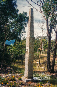
Photograph, Hume and Hovell Monument, Avenel, Spring Excursion, Hume and Hovell's 1824 expedition (Part 2), 26 October 1997, 26/10/1997
... The Swanpool monument states that they passed four miles south and returned three miles north. ...The Swanpool monument states that they passed four miles south and returned three miles north. ...[article by Diana Bassett-Smith in EDHS Newsletter No. 117, November 1997:] MONUMENT HUNTING THE HUME AND HOVELL WAY - Sunday October 26 1997 dawned bright and very warm. Some twenty-five members, complete with picnic baskets, met outside the Eltham Library awaiting the Cobb and Co. large coach which would be taking us on the second leg of our travels along the route of the early explorers Hume and Hovell. Stephen West was our very good driver for the day. He would be guided around the circuitous route by Russell Yeoman who had made a detailed study, not only of the intended route, but of the story of these two explorers. During the trip Russell regaled us with poetry, quotations from the Journals and the History of the Shire of Seymour, "The New Crossing Place" by Martindale, 1982, (now Mitchell Shire due to the recent amalgamations). We headed towards the Hume Highway via Greensborough and Cooper Street and proceeded north to our first stop, noting on the way Monument Hill in the distance which is near Kilmore and, according to Russell, well worth the effort to visit as the view across the valley is magnificent. Past Sunday Creek Valley, Mt Piper and Mt Disappointment, all traversed and noted and named by them. We passed through Tallarook, then onto Seymour where we took photos of the monument telling us that Hume and Hovell had passed through on the 28th of October 1824. We also deviated down Hume and Hovell Road viewing deer and emu farming and the Bellbourie property now a sanctuary. Leaving Seymour behind we travelled up the Avenel Road to the Avenel monument, pyramidal in design of four reducing square blocks with a sharply pointed peak, erected in 1924 in memory of the 1824 exploration. The day was warming up and the countryside showing the dryness of the current drought. A parallel note had been made in their journal too of 1824 of the drought appearance of the country they were traversing. At Seven Creeks, Euroa we stopped for some minutes to check the monument placed 20th November 1924 to commemorate their passage on the 29th December 1824. More photos. Russell had pointed out the abrupt termination of the distant ranges which is noted in their journal. The next monument is beside the road at the entrance to Honey Suckle Creek Caravan Park, Violet Town. The squarish shaped monument some eight feet high is topped with a simple steel cross, and was to mark the date of 28th December 1824 and built for the 20th November 1924. By now it was 12.20 and nearly lunchtime as we drove along the Warranbayne Road to Roach's Road, monument hunting without success. Though there is a large, what appears to be an old timber sign which was hard to read, maybe this was the lost monument. In many of the paddocks hay had been cut and baled or was being cut, what a contrast to the rugged country they had passed through which was smoky from the fires of the natives burning off. By 1.00 pm we were at Benalla and pulled up beside the park where abundant beds of roses filled the air with their scent and the smell of barbecued food twitched the nostrils whilst the cheerful sounds of other picnickers could be heard throughout the park. We left the bus and collected up our picnics, dispersed to the various tables and enjoyed the shade from the various European trees. 2.00 pm and we were on the road again driving along the Benalla, Mansfield, Yea road. The Swanpool monument states that they passed four miles south and returned three miles north. Then we stopped at the Barjarg monument which notes that they camped near this spot. It is again a pyramidal monument and this time topped with a steel arrow indicating their route of the 29th November 1824. Half an hour later we came to another monument, again with a steel arrow marker on top and the plaque dated the 2nd of 12th 1824. Erected on the 12th of 12th 1924. "They blazed the way that we might inherit the land." Another square based and needle topped monument appeared at Yarck near Yea and this plaque records the date of 3 December 1824. Near McGuigans Road Russell related that the expedition had lost a dog but it had found them next day, the dog was apparently torn by a kangaroo. A short while later Russell reminded us here of the problems they encountered in crossing the Goulburn River near Molesworth where banks were high, water deep and wide. "Good coat of grass but quite dry due to drought". At Yea we stopped for afternoon tea and raided the last of our picnics and looked at the monument to their journey of 1824, situated at a corner of the gardens near the bowling green. No photo – we were out of film. We returned home via Kinglake West and Whittlesea past the Yan Yean Reservoir, not full. 5.00 pm back at Eltham we emptied out of the bus and everyone, including Joan Cole, collected their things, Joan also had the major souvenir of the day, a large carp she had picked up from the river bank, her cat was in for a great feast. The day was made so interesting by the informed commentary which Russell provided. His background knowledge of the route and nature of the journey could only have come from many hours of reading and driving the area. Thank you to Russell and to everyone who made the day so informative and pleasurable. Colour photographactivities, hume and hovell, avenel, monument -
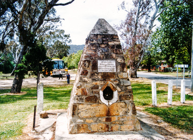 Eltham District Historical Society Inc
Photograph, Hume and Hovell Monument, Seven Creeks, Euroa (29.12.1824), Spring Excursion, Hume and Hovell's 1824 expedition (Part 2), 26 October 1997, 26/10/1997
... The Swanpool monument states that they passed four miles south and returned three miles north. ...The Swanpool monument states that they passed four miles south and returned three miles north. ...[article by Diana Bassett-Smith in EDHS Newsletter No. 117, November 1997:] MONUMENT HUNTING THE HUME AND HOVELL WAY - Sunday October 26 1997 dawned bright and very warm. Some twenty-five members, complete with picnic baskets, met outside the Eltham Library awaiting the Cobb and Co. large coach which would be taking us on the second leg of our travels along the route of the early explorers Hume and Hovell. Stephen West was our very good driver for the day. He would be guided around the circuitous route by Russell Yeoman who had made a detailed study, not only of the intended route, but of the story of these two explorers. During the trip Russell regaled us with poetry, quotations from the Journals and the History of the Shire of Seymour, "The New Crossing Place" by Martindale, 1982, (now Mitchell Shire due to the recent amalgamations). We headed towards the Hume Highway via Greensborough and Cooper Street and proceeded north to our first stop, noting on the way Monument Hill in the distance which is near Kilmore and, according to Russell, well worth the effort to visit as the view across the valley is magnificent. Past Sunday Creek Valley, Mt Piper and Mt Disappointment, all traversed and noted and named by them. We passed through Tallarook, then onto Seymour where we took photos of the monument telling us that Hume and Hovell had passed through on the 28th of October 1824. We also deviated down Hume and Hovell Road viewing deer and emu farming and the Bellbourie property now a sanctuary. Leaving Seymour behind we travelled up the Avenel Road to the Avenel monument, pyramidal in design of four reducing square blocks with a sharply pointed peak, erected in 1924 in memory of the 1824 exploration. The day was warming up and the countryside showing the dryness of the current drought. A parallel note had been made in their journal too of 1824 of the drought appearance of the country they were traversing. At Seven Creeks, Euroa we stopped for some minutes to check the monument placed 20th November 1924 to commemorate their passage on the 29th December 1824. More photos. Russell had pointed out the abrupt termination of the distant ranges which is noted in their journal. The next monument is beside the road at the entrance to Honey Suckle Creek Caravan Park, Violet Town. The squarish shaped monument some eight feet high is topped with a simple steel cross, and was to mark the date of 28th December 1824 and built for the 20th November 1924. By now it was 12.20 and nearly lunchtime as we drove along the Warranbayne Road to Roach's Road, monument hunting without success. Though there is a large, what appears to be an old timber sign which was hard to read, maybe this was the lost monument. In many of the paddocks hay had been cut and baled or was being cut, what a contrast to the rugged country they had passed through which was smoky from the fires of the natives burning off. By 1.00 pm we were at Benalla and pulled up beside the park where abundant beds of roses filled the air with their scent and the smell of barbecued food twitched the nostrils whilst the cheerful sounds of other picnickers could be heard throughout the park. We left the bus and collected up our picnics, dispersed to the various tables and enjoyed the shade from the various European trees. 2.00 pm and we were on the road again driving along the Benalla, Mansfield, Yea road. The Swanpool monument states that they passed four miles south and returned three miles north. Then we stopped at the Barjarg monument which notes that they camped near this spot. It is again a pyramidal monument and this time topped with a steel arrow indicating their route of the 29th November 1824. Half an hour later we came to another monument, again with a steel arrow marker on top and the plaque dated the 2nd of 12th 1824. Erected on the 12th of 12th 1924. "They blazed the way that we might inherit the land." Another square based and needle topped monument appeared at Yarck near Yea and this plaque records the date of 3 December 1824. Near McGuigans Road Russell related that the expedition had lost a dog but it had found them next day, the dog was apparently torn by a kangaroo. A short while later Russell reminded us here of the problems they encountered in crossing the Goulburn River near Molesworth where banks were high, water deep and wide. "Good coat of grass but quite dry due to drought". At Yea we stopped for afternoon tea and raided the last of our picnics and looked at the monument to their journey of 1824, situated at a corner of the gardens near the bowling green. No photo – we were out of film. We returned home via Kinglake West and Whittlesea past the Yan Yean Reservoir, not full. 5.00 pm back at Eltham we emptied out of the bus and everyone, including Joan Cole, collected their things, Joan also had the major souvenir of the day, a large carp she had picked up from the river bank, her cat was in for a great feast. The day was made so interesting by the informed commentary which Russell provided. His background knowledge of the route and nature of the journey could only have come from many hours of reading and driving the area. Thank you to Russell and to everyone who made the day so informative and pleasurable. Colour photographactivities, hume and hovell, monument, euroa, seven creeks