Showing 211 items matching " south road moorabbin"
-
 Kew Historical Society Inc
Photograph, Stuart Tompkins Studio, Electricity Supply Poles, South Road, Moorabbin, 1965
... Electricity Supply Poles, South Road, Moorabbin...Electricity Supply Poles, South Road, Moorabbin, 1965. Stuart Tompkins Studio provided this photograph for the Kew City Council. ...Photographed for Kew City Council 8/2/65. No.2 South Road - Moorabbin, west of Jasper Road, looking east. ...Photographed for Kew City Council 8/2/65. No.2 South Road - Moorabbin, west of Jasper Road, looking east. ...Research provided by Stuart Tompkins Studio, Box Hill, into alternatives for median strip street lighting to be used in Burke Road, Kew. The photographers identified variants in different suburbs appropriate to Kew's needs.The series from which the photograph is drawn provides a snapshot by a commercial photographic studio of each named vicinity in 1965 as well as providing examples of public works infrastructure being commissioned by local government in the 1960s. The photos originally formed part of the Engineering Department's files in the City of Kew before being donated to the kew Historical Society.Electricity Supply Poles, South Road, Moorabbin, 1965. Stuart Tompkins Studio provided this photograph for the Kew City Council. The photograph of South Road, Moorabbin, west of Jasper Road, looking east depicts steel poles with two lamps in a median strip and supply wires from pole to pole. The poles were described as 100′ apart. The notation on the rear of the photograph was that there were lamps along the median strip except at intersections. A wooden pole is recognised as supporting heavy supply lines across the road. The steel poles in the photograph were said to be between 3′ to 3.5′ whereas the wooden poles were three to 12.25″ in diameter. [There are three copies of this photograph in the Collection.] Typed inscription on reverse: "Electricity Supply Poles. Photographed for Kew City Council 8/2/65. No.2 South Road - Moorabbin, west of Jasper Road, looking east. Steel poles with two lamps in median strip and supply wires from pole to pole along median strip (poles only 100' apart). Lamps along median only except at intersections. Wooden pole supports heavy supply lines across the road. Wooden poles 3' up and 8 1/2" dia. Wooden poles 3' up and 12 1/2 dia." Studio stamp: "Stuart Tompkins Studio. 547 Station Street, Box Hill. WX1439."public infrastructure -- kew (vic.), city of kew - engineers department -
 Kew Historical Society Inc
Photograph, Stuart Tompkins Studio, Electricity Supply Poles, South Road, Moorabbin, 1965
... Electricity Supply Poles, South Road, Moorabbin...Electricity Supply Poles, South Road, Moorabbin, 1965. Stuart Tompkins Studio provided this photograph for the Kew City Council. ...Photographed for Kew City Council 8/2/65. No.2 South Road - Moorabbin, west of Jasper Road, looking east. ...Photographed for Kew City Council 8/2/65. No.2 South Road - Moorabbin, west of Jasper Road, looking east. ...Research provided by Stuart Tompkins Studio, Box Hill, into alternatives for median strip street lighting to be used in Burke Road, Kew. The photographers identified variants in different suburbs appropriate to Kew's needs.The series from which the photograph is drawn provides a snapshot by a commercial photographic studio of each named vicinity in 1965 as well as providing examples of public works infrastructure being commissioned by local government in the 1960s. The photos originally formed part of the Engineering Department's files in the City of Kew before being donated to the kew Historical Society.Electricity Supply Poles, South Road, Moorabbin, 1965. Stuart Tompkins Studio provided this photograph for the Kew City Council. The photograph of South Road, Moorabbin, west of Jasper Road, looking east depicts steel poles with two lamps in a median strip and supply wires from pole to pole. The poles were described as 100′ apart. The notation on the rear of the photograph was that there were lamps along the median strip except at intersections. A wooden pole is recognised as supporting heavy supply lines across the road. The steel poles in the photograph were said to be between 3′ to 3.5′ whereas the wooden poles were three to 12.25″ in diameter. [There are three copies of this photograph in the Collection.] Typed inscription on reverse: "Electricity Supply Poles. Photographed for Kew City Council 8/2/65. No.2 South Road - Moorabbin, west of Jasper Road, looking east. Steel poles with two lamps in median strip and supply wires from pole to pole along median strip (poles only 100' apart). Lamps along median only except at intersections. Wooden pole supports heavy supply lines across the road. Wooden poles 3' up and 8 1/2" dia. Wooden poles 3' up and 12 1/2 dia." Studio stamp: "Stuart Tompkins Studio. 547 Station Street, Box Hill. WX1439."city of kew -- engineers department, public infrastructure -- kew (vic.) -
 Kew Historical Society Inc
Photograph, Stuart Tompkins Studio, Electricity Supply Poles, South Road, Moorabbin, 1965
... Electricity Supply Poles, South Road, Moorabbin...Electricity Supply Poles, South Road, Moorabbin, 1965. Stuart Tompkins Studio provided this photograph for the Kew City Council. ...Photographed for Kew City Council 8/2/65. No.2 South Road - Moorabbin, west of Jasper Road, looking east. ...Electricity Supply Poles, South Road, Moorabbin Photograph Photograph Stuart Tompkins Studio ...Research provided by Stuart Tompkins Studio, Box Hill, into alternatives for median strip street lighting to be used in Burke Road, Kew. The photographers identified variants in different suburbs appropriate to Kew's needs.The series from which the photograph is drawn provides a snapshot by a commercial photographic studio of each named vicinity in 1965 as well as providing examples of public works infrastructure being commissioned by local government in the 1960s. The photos originally formed part of the Engineering Department's files in the City of Kew before being donated to the kew Historical Society.Electricity Supply Poles, South Road, Moorabbin, 1965. Stuart Tompkins Studio provided this photograph for the Kew City Council. The photograph of South Road, Moorabbin, west of Jasper Road, looking east depicts steel poles with two lamps in a median strip and supply wires from pole to pole. The poles were described as 100′ apart. The notation on the rear of the photograph was that there were lamps along the median strip except at intersections. A wooden pole is recognised as supporting heavy supply lines across the road. The steel poles in the photograph were said to be between 3′ to 3.5′ whereas the wooden poles were three to 12.25″ in diameter. [There are three copies of this photograph in the Collection.] Typed inscription on reverse: "Electricity Supply Poles. Photographed for Kew City Council 8/2/65. No.2 South Road - Moorabbin, west of Jasper Road, looking east. Steel poles with two lamps in median strip and supply wires from pole to pole along median strip (poles only 100' apart). Lamps along median only except at intersections. Wooden pole supports heavy supply lines across the road. Wooden poles 3' up and 8 1/2" dia. Wooden poles 3' up and 12 1/2 dia." Studio stamp: "Stuart Tompkins Studio. 547 Station Street, Box Hill. WX1439."stuart tompkins studio, street lighting, south road (moorabin) 1965, public infrastructure -- city of kew, city of kew -- engineer's department -
 City of Kingston
Photograph - Digital image, Black and white, Roads - Junction of Nepean Highway and South Road, c. 1950
... ...South Road...Moorabbin...Junction of Nepean Highway and South Road, Moorabbin - Moorabbin Hotel on right. ...City of Kingston Parkdale Library 96 Parkers Road, Parkdale Parkdale Junction of Nepean Highway and South Road, Moorabbin - Moorabbin Hotel on right. Shops in centre demolished for road widening in 1980's Nepean Highway South Road Moorabbin Moorabbin Hotel Printed in black text a round white sticker: 234 Handwritten in red ink 80% Yellow post it note written in blue ink: CHAP 7 234 / - Nepean Hwy + South Road Black and white image of Nepean Highway and South Road junction point of view from Kingston Town Hall Roads - Junction of Nepean Highway and South Road Photograph Digital image, Black and white ...Junction of Nepean Highway and South Road, Moorabbin - Moorabbin Hotel on right. Shops in centre demolished for road widening in 1980'sBlack and white image of Nepean Highway and South Road junction point of view from Kingston Town HallPrinted in black text a round white sticker: 234 Handwritten in red ink 80% Yellow post it note written in blue ink: CHAP 7 234 / - Nepean Hwy + South Roadnepean highway, south road, moorabbin, moorabbin hotel -
 City of Kingston
Photograph - Colour, c. 1982
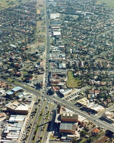
... ...South Road...Moorabbin...This aerial photograph of South Road and Nepean Highway, Moorabbin shows the area where houses and shops on the south side of the Nepean Highway have demolished for the widening of the highway. ...Colour photograph of an aerial view of South Road and Nepean Highway, Moorabbin. The image shows houses on the south side of the Nepean Highway that have demolished for widening of road. ...Nepean Highway South Road Moorabbin Roads Transport Infrastructure Handwritten blue ink: 82 - 5452 - 11 Handwritten red ink: 112% Handwritten black ink: Ch. 7 Colour photograph of an aerial view of South Road and Nepean Highway, Moorabbin. ...This aerial photograph of South Road and Nepean Highway, Moorabbin shows the area where houses and shops on the south side of the Nepean Highway have demolished for the widening of the highway. The pressures of rapid urban development in Moorabbin and beyond, especially to the south of Moorabbin caused bottlenecks and delays, especially at the South Road and Nepean Highway intersection, hence the scheme to widen Nepean Highway.The pressures of rapid urban development in terms of people, housing construction, industrial development and commercial activity, in Moorabbin and beyond, especially to the south would put pressure on road infrastructure in the region. In the early 1980s, a major road expansion of the Nepean Highway was implemented to increase capacity on this major thoroughfare for vehicle commuters. Car use had also increased with commuters from the increasingly populous southern suburbs travelling to their place of work in the Melbourne CBD.Colour photograph of an aerial view of South Road and Nepean Highway, Moorabbin. The image shows houses on the south side of the Nepean Highway that have demolished for widening of road. It features housing and commercial buildings looking north towards Cummins Road.Handwritten blue ink: 82 - 5452 - 11 Handwritten red ink: 112% Handwritten black ink: Ch. 7nepean highway, south road, moorabbin, roads, transport, infrastructure -
 City of Kingston
Photograph - Black and white, c. 1950
... Black and white photograph of the railway crossing at South Road, Moorabbin, viewed from Nepean Highway. ... Railway Railway crossing Handwritten in blue ink on reverse: 217 Handwritten in red ink on reverse: 80% Black and white photograph of the railway crossing at South Road, Moorabbin, viewed from Nepean Highway. ...This image shows a sealed road running along South Road, although with a wide gravel shoulder. The railway crossing gates were hand operated. This image is one of many in the collections that focuses on the railway. The development of the railway was crucial to the ongoing development of the area. Community life often sprang up along and beside the railway.Black and white photograph of the railway crossing at South Road, Moorabbin, viewed from Nepean Highway. Handwritten in blue ink on reverse: 217 Handwritten in red ink on reverse: 80%moorabbin, railway, railway crossing -
 City of Kingston
Photograph - Black and white, c. 1910
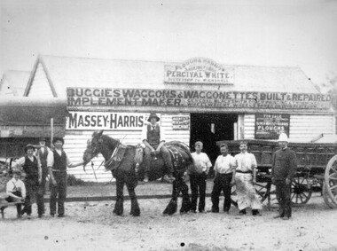
... Percival White was a blacksmith who set up shop in South Road, Moorabbin. The advertising on the front of the shop indicates he also made and repaired buggies, wagons, etc....Black and white image of a group of men, standing either side of a Clydesdale horse, in front of Percival White's shop in South Road, Moorabbin. The man to the far right appears to be in a military or police uniform. ...City of Kingston Parkdale Library 96 Parkers Road, Parkdale Parkdale Percival White was a blacksmith who set up shop in South Road, Moorabbin. The advertising on the front of the shop indicates he also made and repaired buggies, wagons, etc. ...Percival White was a blacksmith who set up shop in South Road, Moorabbin. The advertising on the front of the shop indicates he also made and repaired buggies, wagons, etc.Percival White opened his blacksmith shop in 1853. The business continued until 1973.Black and white image of a group of men, standing either side of a Clydesdale horse, in front of Percival White's shop in South Road, Moorabbin. The man to the far right appears to be in a military or police uniform. The man immediately next to him is wearing a long apron. There are two more men standing in a row and then the Clydesdale. There is a man sitting sideways on the horse. Another man is holding the horse by the reins. Another man is standing next to him, with his hands on his hips and another man, or boy, is seated. In the background there is another man with a long white beard.Handwritten in blue ink on reverse: 124 Handwritten in red ink on reverse: 55%moorabbin, blacksmith, repair -
 Kingston Arts
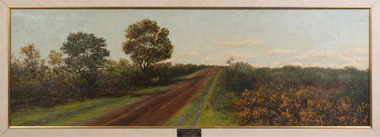
Painting, Edith Slaney, South Road near Bignell Road - Moorabbin, 1903
... South Road near Bignell Road - Moorabbin...Kingston Arts 979 Nepean Hwy (Cnr South Road and Nepean Hwy, 100 metres from Moorabbin train station) Moorabbin melbourne South Road near Bignell Road - Moorabbin Painting Edith Slaney ... -
 St Kilda Historical Society
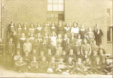
Photograph, St Kilda (Brighton Road)Primary School
... Thomeson (?). 721 South Road, Moorabbin. Donated to the Historical Society....Thomeson (?). 721 South Road, Moorabbin. Donated to the Historical Society. sepia photograph mounted fair condition St Kilda (Brighton Road)Primary School Photograph ...Unable to read date in photograph but children's clothing suggests early 1900ssepia photograph mounted fair conditionSt Kilda (Brighton Road)Primary School. (?) Thomeson (?). 721 South Road, Moorabbin. Donated to the Historical Society. -
 Linton Mechanics Institute and Free Library Collection
Book - Novel, Grimstead, Hettie, Strangers may kiss, 1952
... Stamp and book plate indicating book previously in another collection: 'Balbi Book Club, 360 South Road, Moorabbin'....Linton Mechanics Institute and Free Library Collection 69 Sussex St Linton 3360 Hetti Grimstead Fiction Romance Stamp and book plate indicating book previously in another collection: 'Balbi Book Club, 360 South Road, Moorabbin'. 224 p.: brown cover, section of original dust jacket pasted to front, with image of a woman in evening wear in foreground, a man sitting just behind her, and another woman in the background. ...224 p.: brown cover, section of original dust jacket pasted to front, with image of a woman in evening wear in foreground, a man sitting just behind her, and another woman in the background.fictionhetti grimstead, fiction, romance -
 City of Kingston
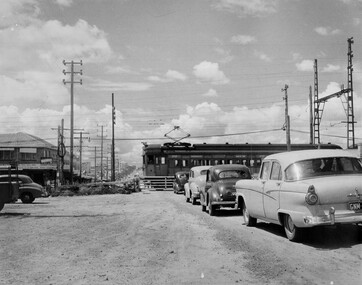
Photograph - Black and white, c. 1957
... Black and white photograph depicting the railway crossing at South Road, Moorabbin. There is a 'Red Rattler' passenger train going through the level crossing travelling towards the city....Road, Parkdale Parkdale This image depicts the increasing urbanisation of Moorabbin. While there are several cars in line waiting for the train to go through the crossing and the gates to open, in the distance there is a lot of activity on the road, with many cars. Moorabbin Trains Cars Urbanisation Suburbs Handwritten in blue ink on reverse: 57-4078 Handwritten in red ink on reverse: 82% Handwritten in black ink on reverse: Ch. 6 Black and white photograph depicting the railway crossing at South Road, Moorabbin. ...This image depicts the increasing urbanisation of Moorabbin. While there are several cars in line waiting for the train to go through the crossing and the gates to open, in the distance there is a lot of activity on the road, with many cars.Black and white photograph depicting the railway crossing at South Road, Moorabbin. There is a 'Red Rattler' passenger train going through the level crossing travelling towards the city.Handwritten in blue ink on reverse: 57-4078 Handwritten in red ink on reverse: 82% Handwritten in black ink on reverse: Ch. 6moorabbin, trains, cars, urbanisation, suburbs -
Glen Eira Historical Society
Map - Orienteering
... ... South Road Moorabbin...Bayside Kangaroos Orienteering Bentleigh East Sedunary Vic Leicester Paul Sheahan Jenny Clubs Sheahan John Tamblyn Greg Centre Road Bentleigh Tucker Road Bentleigh South Road Moorabbin Associations Nepean Highway Bentleigh RSL Club Orienteering Sports Recreations Map Orienteering ...This file contains one item. A map/plan of the Bentleigh East Running Roulette for the Monday series on 21/03/2011.bayside kangaroos orienteering, bentleigh east, sedunary vic, leicester paul, sheahan jenny, clubs, sheahan john, tamblyn greg, centre road bentleigh, tucker road bentleigh, south road moorabbin, associations, nepean highway, bentleigh rsl club, orienteering, sports, recreations -
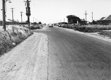
 City of Kingston
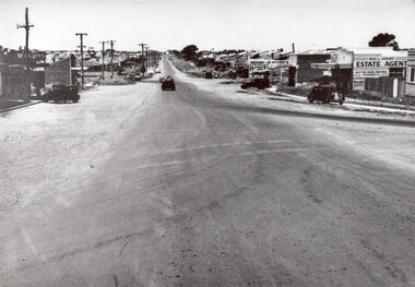
Photograph - Black and white, 1950
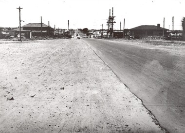
... Black and white photograph of South Road, Moorabbin, with Station Street to the right and Jasper Road further down to the left. ...Road, Parkdale Parkdale This photograph depicts the increasing urbanisation of a once rural area at Moorabbin. This image is one of many in the collections that focuses on either roads or the railway. The development of roads and the railway was crucial to the ongoing development of the area. Moorabbin Roads Cars Shopping strip Housing Handwritten in red ink on reverse: 80% Handwritten in blue ink on reverse: 216 Black and white photograph of South ...This photograph depicts the increasing urbanisation of a once rural area at Moorabbin.This image is one of many in the collections that focuses on either roads or the railway. The development of roads and the railway was crucial to the ongoing development of the area. Black and white photograph of South Road, Moorabbin, with Station Street to the right and Jasper Road further down to the left. Along both sides of the road are retail spaces which become homes on the left hand side, after Jasper Road.Handwritten in red ink on reverse: 80% Handwritten in blue ink on reverse: 216moorabbin, roads, cars, shopping strip, housing -
 City of Kingston
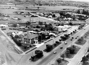
Photograph - Black and white, c. 1930
... Black and white photograph of aerial view of intersection of Nepean Highway and South Road. Moorabbin Council Chambers are situated on the corner with the library, old shire building, Moorabbin railway station, St David's Anglican Church market gardens and open paddocks in the background....Moorabbin Council Railway station Railway Suburbs Paddocks Nepean Highway White round sticker on reverse with black printed text: 143 Handwritten in red ink on reverse: 156% / k000786 Black and white photograph of aerial view of intersection of Nepean Highway and South Road. Moorabbin Council Chambers are situated on the corner with the library, old shire building, Moorabbin railway station, St David's Anglican Church market gardens and open paddocks in the background. ...During the 1930s Moorabbin was an area with open grasslands, still often used for market gardening. The development of the city (and, later, suburb) can be seen emerging from the railway station.The Nepean Highway is a major highway running through the City of Kingston. This image is one of many that depicts its importance to the local community as it undergoes many changes over time.Black and white photograph of aerial view of intersection of Nepean Highway and South Road. Moorabbin Council Chambers are situated on the corner with the library, old shire building, Moorabbin railway station, St David's Anglican Church market gardens and open paddocks in the background.White round sticker on reverse with black printed text: 143 Handwritten in red ink on reverse: 156% / k000786moorabbin, council, railway station, railway, suburbs, paddocks, nepean highway -
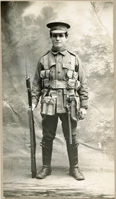 City of Moorabbin Historical Society (Operating the Box Cottage Museum)
Photograph, 1916 William Henry Thomas in WW1 Uniform, 1916 William Henry Thomas in WW1 Uniform, 1916
... road...south brighton...moorabbin...1916 William Henry Thomas of Keys Road , South Brighton (now Moorabbin ) in WW 1 1914 -1918 1st AIF uniform. ...City of Moorabbin Historical Society (Operating the Box Cottage Museum) Joyce Park Jasper Road Ormond melbourne 1916 William Henry Thomas of Keys Road , South Brighton (now Moorabbin ) in WW 1 1914 -1918 1st AIF uniform. ...1916 William Henry Thomas of Keys Road , South Brighton (now Moorabbin ) in WW 1 1914 -1918 1st AIF uniform. William was born in 1894 , Christened at the Wesleyan Church. (Methodist), Wickham Road, South Brighton and attended Moorabbin State School. . Private Thomas was a market gardener in Moorabbin prior to his enlistment in the Australian Imperial Force on 19 July 1915. Both his parents wrote separate letters giving their consent for their son to serve overseas due to " the pressing request of my son William Henry, also the urgent need of recruits do give my consent that he shall go to the front." September 29th 1915 he left Australia with the 5th Reinforcements of the 24th Battalion for Egypt. March 1916 he was hospitalised with Mumps and shortly after left Alexandria to join the British Expeditionary Force for France where he transferred to the 6th Australian Machine Gun Company.. Whilst on leave in England he received medical attention before returning to France and 13 November 1918 he spent a week in the care of the 7rh Field Ambulance suffering with influenza . Private Thomas returned to Australia on the hospital transport Castalia 13 April 1919 and his enlistment was terminated 26 September 1919Private William Henry Thomas and his family are examples of the patriotism exhibited by the market gardeners, and indeed throughout Australia, during the World War 1 1914-1918. Photograph is black and white. William Henry Thomas is standing straight and tall in the centre of the photograph, looking directly at the photographer while holding a weapon in his right hand. He is in his military uniform (WW1) .Front of Mount : Ainor Studio Auburn Back of Mount : William Henry Thomas / 1st World War 1916 / Keys Rd., Moorabbin / Born 1894 / Christened at Wesleyan ( Methodist ) Church / Wickham Rd., / South Brighton / now Uniting Church unsigned undatedwilliam henry thomas, 1916, 1894, first ww, world war one, uniform, wickham road, south brighton, moorabbin, world war 1 1914- 1918, thomas street,early settlers, pioneers, market gardeners, australian infantry force, soldiers, key's cup, victorian war memorials, cheltenham, mckinnon,, keys road moorabbin, ss castalia, british expeditionary force ww1 1914- 1918, 24th battalion 1st aif, 6th australian machine gun company 1st aif, influenza epidemic 1919, alexandria egypt, methodist church, -
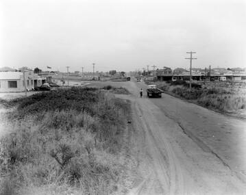
 City of Kingston
Photograph - Black and white, c. 1950
... A car travelling along South Road Moorabbin, with the Tucker Road intersection on the left hand side. ...City of Kingston Parkdale Library 96 Parkers Road, Parkdale Parkdale A car travelling along South Road Moorabbin, with the Tucker Road intersection on the left hand side. ...A car travelling along South Road Moorabbin, with the Tucker Road intersection on the left hand side. Houses are on either side of the road which also has wide shoulders and nature strips.A car travelling along a sealed road with wide shoulders and houses on either side of the road.Handwritten in red ink on reverse: 72% Handwritten in blue ink on reverse: 2192 [circle around all text, including red ink]transport, moorabbin, cars, houses -
Glen Eira Historical Society
Article - MCKINNON
... South Road... Ormond... Brighton... Moorabbin...Moorabbin A Pictorial History 1862-1994 by John Cribben. Includes photocopied pages of railway gates, five land estate flyers and an article from the McKinnon Progress, undated. McKinnon Cribben John Crop Production Markets Farmers Elster Creek McMillan Archibald Thomas Street Centre Road Wheatley Road Vineyards South Road Ormond Brighton Moorabbin Irish Immigrants Bentleigh Priests Hanrahan Pierce Hanrahan Johanna Caroll Michael Caroll Catherine Howes Eliza Howes John Howes Edward Shanahan Denis Shanahan Ellen Gould James Gould Catherine Howes George Bignell Road Jasper Road Tucker Road McGuiness Family Quinn Family Halinan Family Malane Family Inns The Gardeners Arms McKinnon Hotel Bent James Bent Thomas Tickets of Leave Murray Road Were Nicholas Sargood Family Ripponlea Mansions Elsternwick St. ...Brief typed history of McKinnon settlement taken from Moorabbin A Pictorial History 1862-1994 by John Cribben. Includes photocopied pages of railway gates, five land estate flyers and an article from the McKinnon Progress, undated.mckinnon, cribben john, crop production, markets, farmers, elster creek, mcmillan archibald, thomas street, centre road, wheatley road, vineyards, south road, ormond, brighton, moorabbin, irish, immigrants, bentleigh, priests, hanrahan pierce, hanrahan johanna, caroll michael, caroll catherine, howes eliza, howes john, howes edward, shanahan denis, shanahan ellen, gould james, gould catherine, howes george, bignell road, jasper road, tucker road, mcguiness family, quinn family, halinan family, malane family, inns, the gardeners arms, mckinnon hotel, bent james, bent thomas, tickets of leave, murray road, were nicholas, sargood family, ripponlea, mansions, elsternwick, st. stephens’ common school, church of england, school houses, evelyn street, st. john’s anglican church, telegraph offices, post offices, state schools, manchester road, north road, nicholls buildings, rivers frank, rivers ray, shops, pridgeon mr., elm grove, sobrin mr., clark misses, greaves bakery, armitage mrs., rout mr., tunnicliffe mrs., lance’s milk bar, johnson’s hardware shop, stiringer mrs., white horrie, robinson’s, mcinnerney’s flower shop, jean darling’s cakes, wyles jim, mckinnon progress association, glen orme avenue, ormond theatre, theatres, lester harry, the plaza, railway crossing, railway gates, wright street, nichols l., builders, pine grove, halls, st. elmo estate, patterson station estate, patterson road, brewer road, purton road, clee hill estate, railway park, hawthorn grove, wattle grove, elm grove, learys estate, manchester road, selkirk avenue, masters estate, lancaster street, moylan street, moorabbin railway crossing -
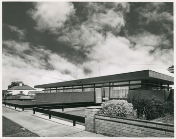 Royal District Nursing Service (now known as Bolton Clarke)
Photograph - Photograph, black and white, 30 06 1965
... This photograph is a record of the Melbourne District Nursing Service (MDNS) Moorabbin Centre, situated at 611 South Road, Moorabbin. It was opened in mid 1965 and was the fourth Centre MDNS had opened. ...Royal District Nursing Service (now known as Bolton Clarke) Level1, 347 Burwood High Way Forest Hill melbourne This photograph is a record of the Melbourne District Nursing Service (MDNS) Moorabbin Centre, situated at 611 South Road, Moorabbin. It was opened in mid 1965 and was the fourth Centre MDNS had opened. ...This photograph is a record of the Melbourne District Nursing Service (MDNS) Moorabbin Centre, situated at 611 South Road, Moorabbin. It was opened in mid 1965 and was the fourth Centre MDNS had opened. Following Royal patronage in 1966, it became known as Royal District Nursing Service (RDNS) Moorabbin Centre.Gradually over the years, Melbourne District Nursing Service, MDNS, later known as Royal District Nursing Service, RDNS, from 1966 when they received Royal patronage, opened Centres throughout the Melbourne Metropolitan area. Their Trained nurses (Sisters) left from these Centres each morning to carry out their nursing visits in a specific area, taking any sterilized equipment needed with them. They returned at the end of the day to write up their patients nursing histories, clean and reset any equipment used ready for sterilization, and to contact other medical personal as necessary. Most of the RDNS cars were housed at each Centre, only a few being driven home by a Sister.Black and white photograph of RDNS Moorabbin Centre. The building is a single story brick building with a flat roof. A row of short glass windows are seen above the brick work to the left of the large glass doors which are on the right of the building. A low standing horizontal fence is seen along the front and along either side of the path leading up to the door. Some bushes are seen in the right hand side garden of the building. A footpath can be seen in front of the fence. On the left of the photograph can be seen a white house with a pitched roof. A dark sky with fluffy white 'cumulus' clouds are seen above the buildings.Photographers stamp. Quote No. DX 18mdns, melbourne district nursing service, mdns centres, royal district nursing service, rdns -
 City of Kingston
Photograph - Black and white, 1957
... Black and white photograph of the intersection of South Road and Chesterville Road, Moorabbin. A service station is visible on the left hand side, a truck is travelling along the road and shops are under construction on the right hand side....Road, Parkdale Parkdale This image shows the increasing urbanisation of the formerly rural area of Moorabbin. Moorabbin Shopping strip Paddocks Roads Cars Handwritten in blue ink on reverse: 57-523B Handwritten in red ink on reverse: 100% Black and white photograph of the intersection of South Road and Chesterville Road, Moorabbin. ...This image shows the increasing urbanisation of the formerly rural area of Moorabbin.Black and white photograph of the intersection of South Road and Chesterville Road, Moorabbin. A service station is visible on the left hand side, a truck is travelling along the road and shops are under construction on the right hand side.Handwritten in blue ink on reverse: 57-523B Handwritten in red ink on reverse: 100%moorabbin, shopping strip, paddocks, roads, cars -
 City of Moorabbin Historical Society (Operating the Box Cottage Museum)
Photograph, B&W Edith ( Eadie) Florence Box 1890 - 1976, c1890
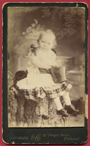
... In 1912 she married Jack Samuel Clay a market gardener in South Road, Moorabbin and they had 6 children. They retired to live in Balnarring, Victoria and are buried in Cheltenham Cemetery. ...City of Moorabbin Historical Society (Operating the Box Cottage Museum) Joyce Park Jasper Road Ormond melbourne Edith (Eadie) Florence Box 1890- 1976, was born in East Brighton ( Bentleigh) the 9th child of Francis and Eliza Jane Box. In 1912 she married Jack Samuel Clay a market gardener in South ...Edith (Eadie) Florence Box 1890- 1976, was born in East Brighton ( Bentleigh) the 9th child of Francis and Eliza Jane Box. In 1912 she married Jack Samuel Clay a market gardener in South Road, Moorabbin and they had 6 children. They retired to live in Balnarring, Victoria and are buried in Cheltenham Cemetery. Francis Box 1836-1912, was born in Withyham, Sussex and came to Australia with his parents George and Mary Box and siblings in 1856. He was assigned to work in Beaufort and had various jobs including ‘gold miner’ at Heathcote where he married Eliza Jane Thompson 1852-1922. Francis decided to return to market gardening after the death of his 1st child Francis George Box in 1875 aged 13months. The child was buried in Brighton Cemetery and Francis then rent/leased the land on the corner of Tucker Road and Elizabeth Street East Brighton ( now Bentleigh) owned by his brother Henry who with another brother John helped Francis clear the land, and establish a market garden. They had 4 children and began to prosper until in 1882 their 2year old child Lena Caroline Box was killed in a fire that destroyed their house. Francis was burned trying to rescue the child. The local community raised money to assist the family. The land boom brought prosperity again and Francis bought more land around Tucker Road which was bequeathed to his children. Francis and Eliza Jane had four more children but one died in infancy and another aged 2 years. Only 5 of their 9 children survived. Francis and Eliza Jane, who died in 1922, are also buried in Brighton Cemetery Box Cottage Museum, a reconstruction of an early settler hut, is named after the Box family who resided there 1865 -1913 . William Box who with his wife Elizabeth Avis Box and 13 children lived and farmed on the block of land in Jasper Road, East Brighton ( now McKinnon / Ormond) that was part of the Henry Dendy Special Survey 1841 . Francis Box, a brother of William Box, was born in Withyham, Sussex and came to Australia with his parents George and Mary Box and siblings in 1856. Francis established market gardens in Tucker Road Bentleigh. Edith 'Eadie' Florence Box was the 9h child of Francis Box. Inscribed in Album “ The early photos in this album were found by Mr (Laurie) Lewis when he was demolishing the Old Box Cottage. He gave them to Mrs Avis Box Eldridge who in turn gave them to me. They were not identified. I believe they rightly belong in the Cottage. I have attempted to identify them and present them in a way they can be preserved as a historical record of the era.” A B Leigh a) A black and white photograph of Edith ( Eadie) Florence Box a daughter of Francis Box and Eliza Jane Thompson Box b) A black and white wedding photograph of Edith Box and John Clay a) YEOMAN & Co 47 Chapel Street / Prahran b) Kodak reprint /handwritten Eadie and John Claycity of moorabbin, brighton, dendy henry, box william, box elizabeth, rietman august, rietman frieda, box cottage museum ormond, box alonzo, glen eira city council, city of moorabbin historical society, ormond, bentleigh, cheltenham, box francis, box eliza jane, box edith florence, clay jack samuel -
 Warrnambool and District Historical Society Inc.
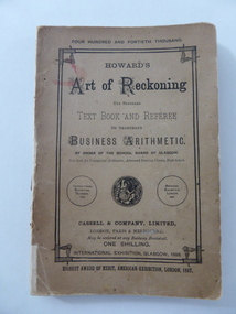
Book, Howard's Art of Reckoning, 1892
... south of Merri St) Warrnambool great-ocean-road This book was written by C. Frusher Howard in 1874 and this copy is the 1892 edition. C. Frusher Howard was the alias of Joseph Ostler (‘Frusher’ was his mother’s maiden name) and he was the first district secretary of the Moorabbin Roads Board. ...This book was written by C. Frusher Howard in 1874 and this copy is the 1892 edition. C. Frusher Howard was the alias of Joseph Ostler (‘Frusher’ was his mother’s maiden name) and he was the first district secretary of the Moorabbin Roads Board. He absconded with its funds in 1867. After some time in the goldfields of U.S.A. and a bigamous marriage he published ‘The Art of Reckoning’ which was highly successful in Britain and U.S.A. He was able to pay back the money he had embezzled. He advertised that he was a Fellow of the Society of Science, Letters and Art, London, but this was a profit-making society owned by an individual and enabled members to wear academic dress and use the title of ‘Professor’. Ostler had in reality no academic qualifications. In the early 1890s he lectured on his ideas on mathematical calculation and publicized his four books in India, Egypt, Palestine and South Africa. In 1896 he returned to Australia and at the 1896-7 Warrnambool Industrial and Art Exhibition Howard gave daily lectures on mathematical calculations and illustrated these with the aid of a blackboard. The inscription in this book does not appear to have any local significance but the book is of interest because the author, C. Frusher Howard, was a lecturer at the Warrnambool Industrial and Art Exhibition of 1896-7. This is a soft cover book of 142 pages. There are several pages at the back of the book advertising other books published by Cassell and Company. The cover is brown with an ornate border on the front cover and black printing on the front cover, spine and back cover. The lettering on the spine has been mostly worn away. The first page has a black and white sketch of the author, C. Frusher Howard, in academic dress. The inscription is handwritten in black ink. ‘C.F. Hamilton, South Heathcote, 1893’ c. frusher howard (joseph ostler), joseph ostler, c. frusher howard -
Glen Eira Historical Society
Document - CAULFIELD CITY CHOIR
... Road... Elsternwick... Hopetown Gardens... Heywood Douglas... Shewan Joan... St. Margaret’s Anglican Church Caulfield... Baptist Church Murrumbeena... Church of Christ Carnegie... St. James’ Lutheran Church Moorabbin... St. Andrew’s Presbyterian Church Caulfield South...Road Elsternwick Hopetown Gardens Heywood Douglas Shewan Joan St. Margaret’s Anglican Church Caulfield Baptist Church Murrumbeena Church of Christ Carnegie St. James’ Lutheran Church Moorabbin St. Andrew’s Presbyterian Church Caulfield South ...This file contains five items: 1/A program of the ‘Second Folk Song Festival’ presented by Caulfield City Choir conducted by David Plummer. Date unknown. 2/Three musical score sheets transcribed by Michael Finnissy for the Caulfield City Choir, dated 1983. 3/A black and white program for the Caulfield City Choir’s Christmas Celebrations at St. John’s Uniting Church on 06/12/1986, conducted by Douglas Heywood. 4/Two black and white programs of presentations given by the Caulfield City Choir and the Camberwell Chorale with the Camerata Orchestra, conducted by Douglas Heywood, at the Camberwell Centre. The first is of the Verdi Requiem on 03/05/1987; the second is ‘The Creation’ by Joseph Haydn on 14/05/1988. 5/A black and white program of the Caulfield City Choir Inc.’s presentation of Victorian Lollipops, conducted by Douglas Heywood at St. Stephen’s Uniting Church Hall on 13/09/1987.emms betty miss, kooyong road, caulfield, caulfield city choir, plummer david, law bernard, butler eric, finnissy michael, murrumbeena, harries rita, st. john’s uniting church, glenhuntly road, glen huntly road, elsternwick, hopetown gardens, heywood douglas, shewan joan, st. margaret’s anglican church caulfield, baptist church murrumbeena, church of christ carnegie, st. james’ lutheran church moorabbin, st. andrew’s presbyterian church caulfield south, holy cross roman catholic church caulfield south, st. john’s uniting church elsternwick, baker tim, sneddon j.f. mrs., snowdon avenue, caulfield city council, caulfield philharmonic society, sneddon marjorie, snedden marjorie, north road, ormond, barnard j., cook d., copley m., duncan d., field b., ford r., fraser g., granger t., greenhaugh h., howells c., jefferies c., kuca m., lockett j., mcalpine c., mcconchie c., mealy m., moorees j., nicholas n., nixon v., polites s., pope m., port m., provelsen m., provelson m., rose r., simmons h., terkuile k., alcock j., bannister j., barnett m., beeson b., cinaglia c., glasson m., griffon b., holmes w., sneddon m., weickhardt j., henderson v., ingram h., ketels m., nutt a., polites c., warden n., dobbin l., mccaffrey p., newbold r., prebble r, shewan j., st. stephen’s uniting church hall, balaclava road, hawthorn road, kooyong road, dobbin leo, heywood thomas, ford dellys, the scotsglen players, caulfield city hall, glen eira road, new city hall, st. stephen’s uniting church, glasson m. mrs, new caulfield city hall, nicholas n. miss, quaife merlyn, ashton-smith david, lukey desmond, reither charles, caulfield town hall, hirst susan, anderson peter, town halls, orchestras, music, people associated with culture, singers, choirs, official buildings, uniting church, festivals and celebrations, musical events and activities, cultural events and activities, musicians, conductors (music), operas, religious festivals, christmas, official buildings, clubs and associations -
Glen Eira Historical Society
Letter - Theatres and Cinemas
... Moorabbin: A Pictorial History, 1862-1994’, by John Cribbin (1995). The notes give a brief history of the Bentleigh Theatre and Ormond Theatre (renamed ‘The Plaza’). Hoyts Theatres Ltd. Gardenvale Mayfair Gardenvale Nepean Theatre Glen Huntly Glen Huntly Theatre Caulfield Crystal Palace Theatre Carnegie Hoyts Carnegie Theatre Elsternwick Hoyts Elsternwick Theatre Esquire Nepean Highway Glenhuntly Road Glen Huntly Road Manchester Grove Dandenong Road Woorayl Street Carre Street Gordon Street Cinemas Theatres Bentleigh Hoyts Bentleigh Caulfield South Camden Carnegie Memorial Rosstown Carnegie Theatre Pohebe Renown Elster Esquire Kadima Sharon Classic Rex Argosy Capri Ormond Theatre The Plaza Depression 1929-1939 Audiences Industry World War 1939-1945 Television Broadcasting Drive-In Theatres Entertainment Bentleigh Theatre Centre Road Nicholson Street Suburban Life Suburbs Community Centres North Road Cribben John Brand Simon Barton Claire Caulfield Historical Society Letter Theatres and Cinemas ...This file contains four items relating to research by members of the Caulfield/Glen Eira Historical Society about theatres and cinemas in Glen Eira: 1/A handwritten copy of a letter from the Caulfield Historical Society to the Secretary of Hoyts requesting information about Hoyts cinemas in Glen Huntly, St. Kilda, Caulfield, Carnegie and Elsternwick. Date unknown. 2/A typed list of cinemas in Glen Eira, dated 07/08/2010 giving their location, name, dates of operation and current status. Researcher unknown. 3/Research notes written by Claire Barton, 02/07/2013, paraphrased from ‘The Pictures and Flea Pits: 80 Years of Australians at the Pictures’ by Simon Brand (1983). The notes give the broader context of cinemas in Australia at the time many Glen Eira cinemas were in operation. 4/Research notes written by Claire Barton, 04/07/2013, paraphrased from ‘Moorabbin: A Pictorial History, 1862-1994’, by John Cribbin (1995). The notes give a brief history of the Bentleigh Theatre and Ormond Theatre (renamed ‘The Plaza’).hoyts theatres ltd., gardenvale, mayfair gardenvale, nepean theatre, glen huntly, glen huntly theatre, caulfield, crystal palace theatre, carnegie, hoyts carnegie theatre, elsternwick, hoyts elsternwick theatre, esquire, nepean highway, glenhuntly road, glen huntly road, manchester grove, dandenong road, woorayl street, carre street, gordon street, cinemas, theatres, bentleigh, hoyts bentleigh, caulfield south, camden, carnegie, memorial, rosstown, carnegie theatre, pohebe, renown, elster, esquire, kadima, sharon, classic, rex, argosy, capri, ormond theatre, the plaza, depression 1929-1939, audiences, industry, world war 1939-1945, television broadcasting, drive-in theatres, entertainment, bentleigh theatre, centre road, nicholson street, suburban life, suburbs, community centres, north road, cribben john, brand simon, barton claire, caulfield historical society -
Glen Eira Historical Society
Document - McKinnon Secondary College
... Glen Eira Historical Society 965 Glen Huntly Rd Caulfield VIC 3162 melbourne File contains 3 items: 1) the school listing from the City of Moorabbin Community Directory Listing 1987, including information about the principal, mothers club and president of the school council 2) an advertisement for a school information night from the Caulfield/ Port Phillip Leader 19/05/2011 3) an advertisement for the school from the Leader News South Edition Dux 2010. McKinnon High School McKinnon Road ...File contains 3 items: 1) the school listing from the City of Moorabbin Community Directory Listing 1987, including information about the principal, mothers club and president of the school council 2) an advertisement for a school information night from the Caulfield/ Port Phillip Leader 19/05/2011 3) an advertisement for the school from the Leader News South Edition Dux 2010.mckinnon high school, mckinnon road, parents clubs, mckinnon secondary college, education, clubs and associations, lawrence alan, schools, donovan noel, colleges, mckinnon, school committees -
Glen Eira Historical Society
Article - St Peter's Catholic Church, Bentleigh East
... Road... Mordialloc Creek... Moorabbin... Springvale... No Good Damper Road... Kingstown... Keysborough... Bignell Road... South...O’ Connell John FR Glass Hugh MR O’ Farrell Peter Brady Peter Kennedy James Boland Michael McCormick Francis Orrong Road Little Brighton Oakleigh Port Phillip Bay East Boundary Road North Road Ormond Old Dandenong Road Mordialloc Creek Moorabbin Springvale No Good Damper Road Kingstown Keysborough Bignell Road South Road Heatherton Big Brighton Gardenvale Elsternwick Brady Road Jasper Road Chesterville Road Cochrane Road McGuinness Road H.A.C.B.S. ...Included In The File is A Newspaper Clipping From The Age Newspaper, Dated Sat 09/11/1974 On The Opening Written By Stuart Sayers. The Article Mentions A Brief History Of The Church & School Beginnings & The Opening Ceremony. There Are Two Copies Of The Living Harvest (One Without The Cover), The Book Gives A Detailed History Of St Peter's Catholic Church, Bentleigh East Written By W.T. Dobson And Published in 1974. From The First White Settlers, The Irish Exodus, And The Irish Catholic families, The School House And The History Of The Parish & Clergy Up To 1974.st peter's catholic church, niall patrick rev, emerald hill, bentleigh east, dobson w. t., yarra, moorabbin, heriot m. b., elsternwick, north road, quinn fred, bentleigh, centre road, kennedy james joseph, melbourne south, bignell road, kennedy market garden, oakleigh, st peter's parish, st james parish, the living harvest, catholic church, hibernian society, bavarian brass band, st peter's primary school, st james regional college, brighton catholic school, brighton – st kilda mission, niall patrick william fr, dendy henry, guiney john mr, king richard, king john, keys george, o’ shanassy john, keys robert, were jonathan b., o’ connell john fr, glass hugh mr, o’ farrell peter, brady peter, kennedy james, boland michael, mccormick francis, orrong road, little brighton, oakleigh, port phillip bay, east boundary road, north road, ormond, old dandenong road, mordialloc creek, moorabbin, springvale, no good damper road, kingstown, keysborough, bignell road, south road, heatherton, big brighton, gardenvale, elsternwick, brady road, jasper road, chesterville road, cochrane road, mcguinness road, h.a.c.b.s., school house, st patrick's church, brighton parish, denominational school, little brighton school, moorabbin catholic school, temporary chapel, st james regional college, sister of mercy, lanigans ball, east brighton public hall company ltd, east bentleigh hall, messrs. robert dunn & son, bavarian brass band, st joan of arc parish, east bentleigh parish, the sisters of our lady of sacred heart, the anchor club, mccormick cornelius, cochrane james, cochrane david, mcguinness margaret, cormick john, cahill james, quinn frederick, prendegast john patrick, naughton dennis, leary william, charlston john, carey matthew fr, gibbons patrick, kennedy joseph james, o’ sullivan tim fr, mckenna fred fr, casey william fr, browne joseph fr, crawford mal fr, hanrahan mr, gillon rose miss, sampson kate mrs, horan miss, coakley daniel fr, dillon kevin fr, whitehouse ray fr, mannix daniel dr, dobson william mr, gahan patrick, hallinan thomas, delaney john, fitzgerald patrick, st peter's catholic church -
Glen Eira Historical Society
Book - St Peter's Catholic Church, Bentleigh East
... Road... Opal Court... The Lighthouse Project... McKenna Centre... Memorial Stone... The Anchor... Bayside Learning... Memorial Garden And Wall... St Peter's School... Presentation Sisters... Daughters Of Our Lady Of The Sacred Heart... Casey Reserve... Outside School Hours Program... Moorleigh Community Centre... St James College... St James College Chapel... Loganville Hostel... Loganville Social Committee... The Beacon... Moongala Drop-In Centre... Berlin Wall Souvenir... St Peter's Memorial Book... Faith And Life Development... Altar Servers... Deaneries... Bentleigh... Chadstone... Clayton... Bentleigh East... Moorabbin East... Murrumbeena... Oakleigh... Ormond... Clayton South...Heriot Maurice FR McKenna Fred FR Wade Terry FR Gebbie Gordon FR Casey William FR Maloney Des FR O’Sullivan FR Guiney John Upton John Stephen Kennedy James O’ Meara Noreen SR Coakley Daniel FR Chevalier Wilma Sierakowski Michael FR Centre Road Bentleigh East Bignell Road Opal Court The Lighthouse Project McKenna Centre Memorial Stone The Anchor Bayside Learning Memorial Garden And Wall St Peter's School Presentation Sisters Daughters Of Our Lady Of The Sacred Heart Casey Reserve Outside School Hours Program Moorleigh Community Centre St James College St James College Chapel Loganville Hostel Loganville Social Committee The Beacon Moongala Drop-In Centre Berlin Wall Souvenir St Peter's Memorial Book Faith And Life Development Altar Servers Deaneries Bentleigh Chadstone Clayton Bentleigh East Moorabbin East Murrumbeena Oakleigh Ormond Clayton South Liturgy Group Friday Mass Sacramental Sponsoring Sunday School Baptism Support Children Liturgy Of The Word Pre Marriage Program Cancer Support Group Ministry To The Sick Loss And Grief Support Junior Youth Support Senior Youth Support Outreach Bingo The Parish Fete White Elephant Young Vinnies St Vincent de Paul Spirituality In The Pub (S.I.P) The Passionist Family Group Movement Rite Of Christian Initiation For Adults (R.C.I.A) Prayer Around The Cross St Peter's Prayer Group St Peter's Choir Antioch Catholic War Veterans Association Memorial Bursary Fund Catechetics St Peter's Catholic Church Book St Peter's Catholic Church, Bentleigh East ...The Golden Harvest Is A Book That Continues The History Of St Peter’s Parish, Bentleigh East From 1984 – 2005. The Book Discusses Community Life For The Previous 25 Years, Specifically Outreach And Services, Liturgy, Faith Education, And Fundraising, Finishing With Recollections From Parishioners.heriot maurice fr, mckenna fred fr, wade terry fr, gebbie gordon fr, casey william fr, maloney des fr, o’sullivan fr, guiney john, upton john stephen, kennedy james, o’ meara noreen sr, coakley daniel fr, chevalier wilma, sierakowski michael fr, centre road, bentleigh east, bignell road, opal court, the lighthouse project, mckenna centre, memorial stone, the anchor, bayside learning, memorial garden and wall, st peter's school, presentation sisters, daughters of our lady of the sacred heart, casey reserve, outside school hours program, moorleigh community centre, st james college, st james college chapel, loganville hostel, loganville social committee, the beacon, moongala drop-in centre, berlin wall souvenir, st peter's memorial book, faith and life development, altar servers, deaneries, bentleigh, chadstone, clayton, bentleigh east, moorabbin east, murrumbeena, oakleigh, ormond, clayton south, liturgy group, friday mass, sacramental sponsoring, sunday school, baptism support, children liturgy of the word, pre marriage program, cancer support group, ministry to the sick, loss and grief support, junior youth support, senior youth support, outreach, bingo, the parish fete, white elephant, young vinnies, st vincent de paul, spirituality in the pub (s.i.p), the passionist family group movement, rite of christian initiation for adults (r.c.i.a), prayer around the cross, st peter's prayer group, st peter's choir, antioch, catholic war veterans association, memorial bursary fund, catechetics, st peter's catholic church -
City of Moorabbin Historical Society (Operating the Box Cottage Museum)
Newsletter, City of Moorabbin Historical Society No. 9 Vol. 3 October 1963, City of Moorabbin Historical Society Newsletter No. 9 Vol. 3 October 1963, 1963
... City of Moorabbin Historical Society (Operating the Box Cottage Museum) Joyce Park Jasper Road Ormond melbourne Topics : CMHS AGM; Mr R Ashley Pres. ; new Mayor Cr Brian Stuart-Jones; Moorabbin News - Local newspaper; East Brighton Hall 1894; St Peter's Hall 1862; removal of 'South Brighton' signs replaced with 'Moorabbin" This is Newsletter No 9 Vol . 3 produced in October 1963 by Mr T. ...Topics : CMHS AGM; Mr R Ashley Pres. ; new Mayor Cr Brian Stuart-Jones; Moorabbin News - Local newspaper; East Brighton Hall 1894; St Peter's Hall 1862; removal of 'South Brighton' signs replaced with 'Moorabbin" This is Newsletter No 9 Vol . 3 produced in October 1963 by Mr T. A. Sheehy CMHS for members and visitors The Aims of the CMHS are ‘to record the history of the City, and register something of the Australian Atmosphere, which the necessary speed-up in post-world-war two (WW11) immigration has caused to be lost; to produce a magazine at regular intervals, featuring the work of pioneers and the changing Australian scene; to work constantly with a long range view towards building a hall where records and exhibits can be housed’ (1961) The Original Newsletters reflect the history and heritage of the former City of Moorabbin — derived from Mooroobin, ‘a resting place’ in the Bunurrung spoken language. In 1994, the City of Moorabbin was integrated into the Cities of Bayside, Glen Eira, Kingston and Monash. This is Newsletter No. 9 Vol. 3 of the CMHS October 1963 CMHS obtained a Kingston City Council Community Grant 2016 for the digitization and preservation of these Original CMHS Newsletters commenced in 1961 1 x Foolscap paper printed on 2 sides folded for 4 pages NEWSLETTER / City of Moorabbin Historical Society. / Vol. 3 No. 9 OCTOBER 1963city of moorabbin historical society 1961, sheehy t.a., newsletters, east brighton, south brighton, moorabbin, bentleigh, -
 City of Moorabbin Historical Society (Operating the Box Cottage Museum)
Manufactured object, Cigar Box J.Van Maurik c1950, c1950
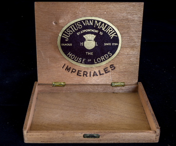
... City of Moorabbin Historical Society (Operating the Box Cottage Museum) Joyce Park Jasper Road Ormond melbourne This is an empty Justus Van Maurik cigar box made c1950 by appointment to the House of Lords, London and the cigars were used by George Reed who was a draftsman in City of Moorabbin c1950. c1700 The Dutch East India Company brought spices from South East Asia and tobacco from the New World to Sumatra and Java in Indonesia. 1794 Justus van Maurik Senior established a tobacco factory in the centre of Amsterdam and his son, Justus van Maurik Junior, spread the company’s fame well beyond the borders of (Holland) Netherlands as he travelled the world successfully promoting the family’s tobacco business. ...This is an empty Justus Van Maurik cigar box made c1950 by appointment to the House of Lords, London and the cigars were used by George Reed who was a draftsman in City of Moorabbin c1950. c1700 The Dutch East India Company brought spices from South East Asia and tobacco from the New World to Sumatra and Java in Indonesia. 1794 Justus van Maurik Senior established a tobacco factory in the centre of Amsterdam and his son, Justus van Maurik Junior, spread the company’s fame well beyond the borders of (Holland) Netherlands as he travelled the world successfully promoting the family’s tobacco business.Dutch cigars were popular c1950 in the City of Moorabbin and Justus van Maurik Pty Ltd was a quality producer from Amsterdam , Holland (Netherlands) commencing production c1794. George Reed was a draftsman who lived in City of Moorabbin c1950 A plywood hinged cigar box Lid ; JUSTUS VAN MAURIK / BY APPOINTMENT TO / FAMOUS H T/M L SINCE 1754/ THE / HOUSE OF LORDS / IMPERIALES Inside Lid ; as above cigars, justus van maurik pty ltd., holland, amsterdam, netherlands, dutch east india company, redheads safety matches, safety matches, bryant & may pty ltd, early settlers, moorabbin, bentleigh, cheltenham, tobacco, reed george, draftsman, architect, moorabbin shire, city of moorabbin, post world war 2 estates -
 City of Moorabbin Historical Society (Operating the Box Cottage Museum)
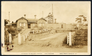
Photograph, Black & White Postcard, Cheltenham Railway Station c1920, c1920
... Cheltenham Railway Station is one of the original cottage style stations ordered by Sir Thomas Bent when the rail line was extended from Caulfield to Mordialloc 1881 railways, cheltenham station, mentone station, south brighton station, railway level crossing removal 2016 -19, smith j l; smith mary ann, stanley helen, smith vic, smith harry redvers, chaff cutter, horse drawn carts, toll gates brighton, motor cars 1900, steam engines, early settlers, bentleigh, parish of moorabbin, city of moorabbin, county of bourke, moorabbin roads board, shire of moorabbin, henry dendy's special survey 1841, were j.b.; bent thomas, o'shannassy john, king richard, charman s, highett william, ormond francis, maynard dennis, market gardeners, vineyards, orchards Valentine &Sons Pub Co Ltd Melb Photograph Black & White Postcard showing the entrance to Cheltenham Railway Station c1920 Photograph, Black & White Postcard, Cheltenham Railway Station c1920 Valentine &Sons Pub Co Ltd Melb ...Although the Railway line had been planned for some time Sir Thomas Bent MP was responsible for making it happen in order to revitalize the fortunes of the Moorabbin Shire that he had represented for so long. The train line opened in 1881with 8 Stations between Caulfield and Mordialloc.The first Steam engine carried dignitaries and local residents. Bent also ensured that the Station houses in his constituency were built in a distinctive decorative cottage style. Bent faced severe criticism for diverting the rail line through his local area and for the expenditure on the Stations. Local residents established and cared for Gardens at the Stations and Cheltenham was awarded Best Garden c1910. The arrival of the Railway Line saw the traders move from Point Nepean Rd to Charman Rd and by 1910 various shops and business were present. 2016 - current has seen large protest rallies against the destruction of Mentone Station and Cheltenham Station as the Victorian State Government proceeds to remove Railway Level Crossings. A compromise to retain the Station buildings whilst placing the Rail Line underground is desired.Cheltenham Railway Station is one of the original cottage style stations ordered by Sir Thomas Bent when the rail line was extended from Caulfield to Mordialloc 1881Photograph Black & White Postcard showing the entrance to Cheltenham Railway Station c1920Valentine &Sons Pub Co Ltd Melb railways, cheltenham station, mentone station, south brighton station, railway level crossing removal 2016 -19, smith j l; smith mary ann, stanley helen, smith vic, smith harry redvers, chaff cutter, horse drawn carts, toll gates brighton, motor cars 1900, steam engines, early settlers, bentleigh, parish of moorabbin, city of moorabbin, county of bourke, moorabbin roads board, shire of moorabbin, henry dendy's special survey 1841, were j.b.; bent thomas, o'shannassy john, king richard, charman s, highett william, ormond francis, maynard dennis, market gardeners, vineyards, orchards -
 City of Moorabbin Historical Society (Operating the Box Cottage Museum)
Photographs,x3 Colour Early Weatherboard Cottage Cheltenham c1880, 1981
... City of Moorabbin Historical Society (Operating the Box Cottage Museum) Joyce Park Jasper Road Ormond melbourne Henry Dendy , a farmer from Sussex England, purchased 5,120 acres of land in the area of a 'Special Survey 1841' that extended from Brighton bayside North Road, East Boundary Rd to South Road. ...Henry Dendy , a farmer from Sussex England, purchased 5,120 acres of land in the area of a 'Special Survey 1841' that extended from Brighton bayside North Road, East Boundary Rd to South Road. This area became known as Dendy's Brighton and as part of the sale 139 emigrant workers arrived in 1842 however Dendy was unable to find work and lodgings for these people. J.B.Were, financier took over the management of the 'Special Survey 1841' area and began to sell and lease allotments. 1850 the Squatter King brothers sold land south of Dendy's 'Special Survey 1841' to Josiah Holloway who sectioned it into 2 acre lots @ £10 each for market gardens - 'Two Acre Village' and Charles Whorral opened a small hotel - 'The Cheltenham Inn' on the main Road - Arthur's Seat Rd, later Point Nepean Rd, now Nepean Highway. Notable settlers who moved into the area were Keys, Charman, Bruton, Le Page, Fairlam, Meeres and 1862 saw the separation from Brighton and the formation of the Mooorabbin Roads Board District. .By 1879 1000settlers were living in 'Cheltenham' serviced by a Post Office with Bank, Mechanics Institute, State School No 84,Keys Hotel, Meeres Store, Sir Thomas Bent ensured the new Railway Line from Caulfield to Mordialloc went through his constituency of Cheltenham 1881 and this changed the development to the bayside area of Cheltenham away from the 'Two Acre Village ' side causing some dissention, However Cheltenham as whole prospered and this house in Pine St is typical of the cottages built c 1890- 1900 in the area. This weatherboard house c 1890-1900 in Pine St Cheltenham is typical of those built for early settler families. Photo taken 1981 by CMHS member 3 x Colour photographs of an early c 1900 weatherboard house in Pine St Cheltenham taken by CMHS member 1981Kodak Aug. 81 / Handwritten Pine St Cheltenhamkeys robert, holloway josiah, king brothers, smith j l; smith mary ann, stanley helen, chaff cutter, horse drawn carts, toll gates brighton, motor cars 1900, steam engines, early settlers, bentleigh, parish of moorabbin, city of moorabbin, county of bourke, moorabbin roads board, shire of moorabbin, henry dendy's special survey 1841, were j.b.; bent thomas, o'shannassy john, king richard, charman stephen, highett william, ormond francis, maynard dennis, market gardeners, vineyards, orchards