Showing 367 items matching " street tree plantings"
-
 Canterbury History Group
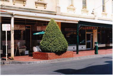
Photograph - Streetscape outside shop No. 84 and No. 82 Maling Road, Jan Pigot, 27/03/1993 12:00:00 AM
... ... Street tree plantings...Canterbury Maling Road Shops Streetscapes Street tree plantings Photograph Streetscape outside shop No. 84 and No. 82 Maling Road Jan Pigot ...canterbury, maling road, shops, streetscapes, street tree plantings -
 Bendigo Historical Society Inc.
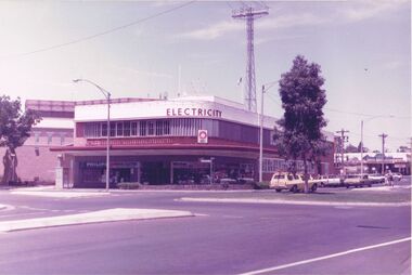
Photograph - CASTLEMAINE GAS COMPANY COLLECTION: PHOTO SEC BUILDING
... Photo of SEC Building at the corner of Williamson and Hargreaves Streets. Tree planted on the roundabout, Tall communications tower in the background, two people standing the safety zone, white station wagon, other cars parked along Williamson Street....History House 11 Mackenzie Street Bendigo goldfields BENDIGO Streetscape williamson street Photo of SEC Building at the corner of Williamson and Hargreaves Streets. Tree planted on the roundabout, Tall communications tower in the background, two people standing the safety zone, white station wagon, other cars parked along Williamson Street. ...Photo of SEC Building at the corner of Williamson and Hargreaves Streets. Tree planted on the roundabout, Tall communications tower in the background, two people standing the safety zone, white station wagon, other cars parked along Williamson Street.bendigo, streetscape, williamson street -
 Port Melbourne Historical & Preservation Society
Plan, Graeme Bentley Pty Ltd, Port Melbourne Foreshore Landscape Master Plan MP2 (A), February 1993
... The plan proposed street tree planting along Beach Street. The plan was not actioned....The plan proposed street tree planting along Beach Street. The plan was not actioned. ...The Port Melbourne Foreshore Landscape Master Plan was created by Landscape Architectural firm of Graeme Bentley Pty Ltd for the City of Port Melbourne. MP2 (A) portrays the section of foreshore from Stokes Street to Dow Street. The plan proposed street tree planting along Beach Street. The plan was not actioned.built environment - recreational facilities, beach street, port melbourne foreshore, station pier -
Port Melbourne Historical & Preservation Society
Plan, Graeme Bentley Pty Ltd, Port Melbourne Foreshore Landscape Master Plan MP4 (B), February 1993
... MP4 (B) portrays the section of foreshore Surrounding the Port Melbourne Lifesaving Club.The plan proposed street tree planting and lawn areas. The plan was not actioned....MP4 (B) portrays the section of foreshore Surrounding the Port Melbourne Lifesaving Club.The plan proposed street tree planting and lawn areas. The plan was not actioned. ...The Port Melbourne Foreshore Landscape Master Plan was created by Landscape Architectural firm of Graeme Bentley Pty Ltd for the City of Port Melbourne. MP4 (B) portrays the section of foreshore Surrounding the Port Melbourne Lifesaving Club.The plan proposed street tree planting and lawn areas. The plan was not actioned.built environment - recreational facilities, beach street, port melbourne foreshore, port melbourne life saving club -
Port Melbourne Historical & Preservation Society
Plan, Graeme Bentley Pty Ltd, Port Melbourne Foreshore Landscape Master Plan MP3 (A), February 1993
... The plan proposed street tree planting along Beach Street and development of a park area opposite Johnson Street. ...The plan proposed street tree planting along Beach Street and development of a park area opposite Johnson Street. ...The Port Melbourne Foreshore Landscape Master Plan was created by Landscape Architectural firm of Graeme Bentley Pty Ltd for the City of Port Melbourne. MP3 (A) portrays the section of foreshore from Dow Street to Pickles Street. The plan proposed street tree planting along Beach Street and development of a park area opposite Johnson Street. The plan was not actioned.built environment - recreational facilities, beach street, port melbourne foreshore -
 University of Melbourne, Burnley Campus Archives
Photograph - Black and white print, E.M. Gibson, View From the Plant Research Institute/Laboratory Towards Swan Street, 1947
... Black and white photograph of the view from the Plant Research Institute/Laboratory towards Swan Street. newly planted trees in the foreground....University of Melbourne, Burnley Campus Archives 500 Yarra Boulevard Richmond melbourne plant research laboratory e. m. gibson collection polant research institute swan street trees 49 Black and white photograph of the view from the Plant Research Institute/Laboratory towards Swan Street. newly planted trees in the foreground. ...Black and white photograph of the view from the Plant Research Institute/Laboratory towards Swan Street. newly planted trees in the foreground.49plant research laboratory, e. m. gibson collection, polant research institute, swan street, trees -
 Surrey Hills Historical Society Collection
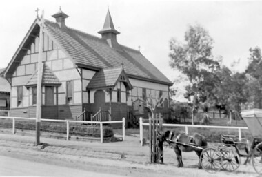
Photograph, Holy Trinity Church of England, Surrey Hills post 1926, After 1926
... Immature street trees are planted on both sides of Union Road....Immature street trees are planted on both sides of Union Road. ...St George's Church of England, Mont Albert was built in 1886 and from 1904 until 1907 was known as Holy Trinity, Surrey Hills. As the population increased there was a need for a church in Surrey Hills. This brick church was consecrated in 1922 and replaced the earlier one built in 1907 on the adjacent site in Union Road. After construction of the brick church, the earlier one became a Sunday School. The copper spire was added in 1926, which dates this photo as post-1926. Norman Carter took many photos of Surrey Hills and Mont Albert in the 1920s; many were associated with events and activities of the Church of England.Black and white photo of the 'newly' constructed brick Holy Trinity Church in Union Road, Surrey Hills taken from near the south-west corner of Guildford Road. Further up the hill is the earlier church. Both buildings are bounded by a simple post and rail fence. Immature street trees are planted on both sides of Union Road.churches, holy trinity church, anglican church, sunday schools, norman carter -
 Linton and District Historical Society Inc
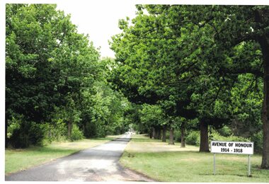
Photograph, Avenue of Honour, Linton, 2014
... Colour photograph which shows trees remaining in Linton's Avenue of Honour in Denison Street, Linton. The trees were planted towards the end of World War I....Linton and District Historical Society Inc 69 Sussex Street Linton 3360 goldfields Avenue of Honour Linton World War 1914-1918 World War I Denison Street Linton Trees Colour photograph which shows trees remaining in Linton's Avenue of Honour in Denison Street, Linton. The trees were planted ...Colour photograph which shows trees remaining in Linton's Avenue of Honour in Denison Street, Linton. The trees were planted towards the end of World War I.avenue of honour linton, world war 1914-1918, world war i, denison street linton, trees -
 Ringwood and District Historical Society
Photograph, Group around new tree Wandin North near E. Reads present home
... tree), Mrs. Chris Russell, Mrs. Ruby Lydster and child and lady unknown, (Thos Tuadion?) Jean Mitchell". Written on back of mounting sheet, "Please return to Mrs. A. Cooke, Smith Street, Healesville. Tree planted...tree), Mrs. Chris Russell, Mrs. Ruby Lydster and child and lady unknown, (Thos Tuadion?) Jean Mitchell". Written on back of mounting sheet, "Please return to Mrs. A. Cooke, Smith Street, Healesville. Tree planted ...Photograph missing from archives after having been scanned and catalogued as follows, however no clear information on location or date:Written on mounting sheet above the photograph, "R.B. Lord, Dolly Lord, Eileen Mitchell, Dot Mitchell, Ethel Mao, James Mitchell??? (Scotty) (around tree), Mrs. Chris Russell, Mrs. Ruby Lydster and child and lady unknown, (Thos Tuadion?) Jean Mitchell". Written on back of mounting sheet, "Please return to Mrs. A. Cooke, Smith Street, Healesville. Tree planted for Harry Lord, Main Road, Wandin North, near E. Reads present home". -
 Surrey Hills Historical Society Collection
Photograph, Churchill Street, Mont Albert and Mont Albert Station, looking towards Hamilton Street, 1919, 1919
... There do not appear to be any shops in Churchill Street. There are newly planted street trees within paling guards on the LHS. ...There do not appear to be any shops in Churchill Street. There are newly planted street trees within paling guards on the LHS. ...The railway extended through to Mont Albert in 1882, but it wasn't until 1890 that a station was built with funds raised by a syndicate of local landowners.The buildings on the south side of the railway were built in 1910-1911 in the Arts and Crafts style by architect, K W Hardy. The land occupied by the Hamilton Street shops was subdivided in the 1880s and the first purpose-built shop was 'Pope and Moran, Grocers'. This shop later became Tom Morris' Grocery. By 1930 shops stretched along both sides of Hamilton Street and part way along Churchill Street. The donor, the late Norman Carter held a significant collection of photos taken around Mont Albert and Surrey Hills, in particular subjects related to the Church of England.Black and white photo taken from the centre of the road in Churchill Street, Mont Albert. Mont Albert station is on the RHS fenced off by a post and rail fence. Shops can be seen at the intersection of Hamilton and Churchill Streets. There do not appear to be any shops in Churchill Street. There are newly planted street trees within paling guards on the LHS. There does not appear to be any curb and channelling at the side of the road.Rear in blue biro in Jocelyn Hall's handwriting "Mont Albert Station 1919".mont albert station, railways, hamilton street, churchill street, shops, arts and crafts style, norman carter -
 Surrey Hills Historical Society Collection
Photograph, Holy Trinity Church, Surrey Hills in the 1920s
... There is a phaeton in the foreground beside a relatively newly planted street tree. The road has bluestone kerb and channelling....There is a phaeton in the foreground beside a relatively newly planted street tree. The road has bluestone kerb and channelling. ...This church was built in 1907 and became known as Holy Trinity Surrey Hills. This name had previously been used by the Anglican Church in Mont Albert Road, Mont Albert. This henceforth became known as St George's Anglican Church, Mont Albert. There are 2 copies: the original donated print and an enlargement. The original is mounted on card with photo mounts along with 890, 891 and 892. It measures 13 cm x 9 cm. Norman Carter took many photos of Surrey Hills and Mont Albert from the 1920s in particular of events and activities associated with the Church of England.Black and white photo of the original Holy Trinity Church building in Union Road. It is constructed of weatherboards, above which there is plasterboard and timber strapping. The roof is of terracotta tiles with a small steeple at the front and a larger one towards the rear of the building. There is a box bay window at the front and the entrance is from a porch on the southern side of the building. This is approached by stairs. Part of the vicarage can be seen on the northern high side of the church and to the south there is vacant land. The whole property sits behind a simple post and wire fence. There is a phaeton in the foreground beside a relatively newly planted street tree. The road has bluestone kerb and channelling.churches, holy trinity church, anglican church, horse-drawn vehicles, norman brodley carter, union road -
 Eltham District Historical Society Inc
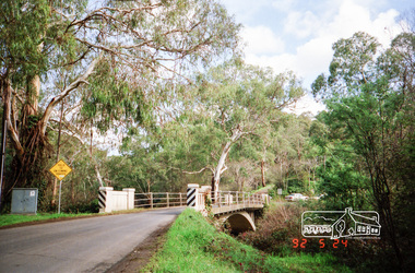
Photograph, Monash Bridge, Arthurs Creek Road, Hurstbridge, Eltham Heritage Tour, 24 May 1992, 24/05/1992
... Close by the kindergarten, at this place are three trees on the National Trust Register, a Canary Island pine, a Canadian cedar and probably a spruce. Radiata pines and a thick bolled peppercorn surround the little cemetery. Continuing along Main Street we notice elm trees planted...Close by the kindergarten, at this place are three trees on the National Trust Register, a Canary Island pine, a Canadian cedar and probably a spruce. Radiata pines and a thick bolled peppercorn surround the little cemetery. Continuing along Main Street we notice elm trees planted ...ELTHAM HERITAGE TOUR The Society excursion on 24th May 1992 was arranged by David Bick, leader of the team carrying out the Shire's heritage study. David selected a number of sites or buildings identified in the study, some of them lesser known components of the Shire's heritage. The tour commenced at the Eltham Shire Office at 10.00 am. Travel was by private car and mini-bus with stops at about twelve locations for commentary by David.It included a short walk in Hurstbridge and lunch at Kinglake. Highlights of the tour included: - 10 am Leave from Shire Offices - 3 Important Trees - A Physical Link to Eltham's First Settlers - Toorak Mansion Gates - A Surviving Farm House - An Intact Circa 1900 Main Street - First Settlers - Gold Miners, and Timber-getters - An Early Hotel - A Pioneering Homestead - Changing Eltham Shire - 20th Century - 4 pm Afternoon Tea and Finish Tour Extract from ELTHAM CULTURAL HERITAGE TOUR (Newsletter No. 85, July 1992, by Bettina Woodburn) "On the Arthurs Creek Road is a bridge designed by Monash, which we admired before walking across the little park with a mud-brick and timber shelter, to the Hurst family graveyard. There are two marked graves, one, Henry who was shot by Burke the bushranger and a cairn has a plaque listing others buried here from 1866 onwards. Burke was captured and tied to the wheel of a dray under the eucalypt near the waterhose/standpipe. Close by the kindergarten, at this place are three trees on the National Trust Register, a Canary Island pine, a Canadian cedar and probably a spruce. Radiata pines and a thick bolled peppercorn surround the little cemetery. Continuing along Main Street we notice elm trees planted as a war memorial, then on the left a 1930 timber house, a 1910 store and residence, resplendent with wrought iron trim, a double fronted Hardware Store and cypresses on the back alignment of a new vacant block. On the right side of the street is a less interesting attempt at an 'in character' shop. Further on are more early homes, one tucked away at the rear with two tall palms by the front steps. Another curiosity is a rounded veranda corner and there are more galvanised iron sheds or garages, before a mud-brick Dentist's Surgery. Beyond the round-a-about is St Peters Church, of mud-brick construction shared by Catholic and Anglican parishioners, overlooking the river flood plain. Leaving Hurstbridge on the Kinglake Road, we ate our picnic lunch beside the communication tower and enjoyed views of Melbourne, Yan Yean Reservoir and the distant Dandenongs beyond the spreading suburbs. Next we drove to the North West boundary of the Shire at Masons Falls Road towards Whittlesea. On the way to the North East Boundary we passed St Peters, a yellow wooden Church with a Tudor Archway; built in the early 1920's in the style of the 1860's. From the Healesville-Kinglake road the rolling hills had European aspects, the hedged fields and chestnut trees. Then it was back down the Hurstbridge Road through 'Aussie' bush of towering gums, with bracken and scrubby understorey, the Kinglake National Park, before more open country with deciduous trees planted in line, and a creek lined with willows."Record of the Society's history and activities and highlighting various aspects of the Heritage Study undertaken by David Bick used to create the future heritage overlay for the Shire of Eltham and later Nillumbik Shire.Roll of 35mm colour negative film, 4 stripsKodak Gold 100 5095shire of eltham historical society, activities, heritage tour, hurstbridge, monash bridge, arthurs creek road -
 Warrnambool and District Historical Society Inc.
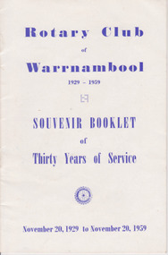
Booklet, Rotary Club of Warrnambool, 1929-1959, Printed prior to November 1959
... Street (south of Merri St) Warrnambool great-ocean-road This booklet relates the history of the first 30 years of service by the Rotary Club of Warrnambool. It gives an overview of the many local projects which have been helped over the years and also lists the club office bearers Its significance lies in the list of projects which were happening in the period 1929-1959 such as assistance to Natural disasters and hardship in the post wars and Depression years as well as community projects such as tree planting and overseas aid.. ...This booklet relates the history of the first 30 years of service by the Rotary Club of Warrnambool. It gives an overview of the many local projects which have been helped over the years and also lists the club office bearers Its significance lies in the list of projects which were happening in the period 1929-1959 such as assistance to Natural disasters and hardship in the post wars and Depression years as well as community projects such as tree planting and overseas aid.. The list of Officebearers is a reflection of community identities and one facet of their contribution to society. In one paragraph state what is significant, the type of significance it holds, and why it is significantWhite Gloss card cover. Front cover has blue text, Rotary Club of Warrnambool 1929-1959, Souvenir Booklet of Thirty Years of Service. Small Rotary International Wheel. November 20, 1929 to November 20, 1959. Back cover Collett &Bain Printers 34 Kepler St Warrnambool. 16 PagesPrinted by Collett & Bain, 34 Kepler St Warrnamboolrotary, rotary club of warrnambool, horace i holmes, charter 3237 -
 Bendigo Military Museum
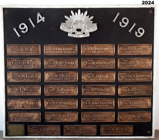
Honour Board - EAST BENDIGO PRIMARY SCHOOL HONOUR BOARD WW1, original plaques, post WW1
... plant an ANZAC Avenue of trees and this was completed on 16 June 1916. The plaques were placed after WW1. The school was closed in 1998 and the plaques were relocated to the nearby White Hills Secondary College in Napier Street on this board. ...plant an ANZAC Avenue of trees and this was completed on 16 June 1916. The plaques were placed after WW1. The school was closed in 1998 and the plaques were relocated to the nearby White Hills Secondary College in Napier Street on this board. ...The Bendigo East Primary School was opened in 1915. In 1916 it was decided to plant an ANZAC Avenue of trees and this was completed on 16 June 1916. The plaques were placed after WW1. The school was closed in 1998 and the plaques were relocated to the nearby White Hills Secondary College in Napier Street on this board. In the early 2000's the Honour Board was donated to what is now called the Bendigo Military Museum. One hundred years after planting, later in 2016 the trees were removed in controversial circumstances. On the board 8 never returned, there is 1 x "DCM" winner, 1 x "MC" winner and 1 x "MM" winner. There are 3 x Wright Brothers of which 2 never returned. The plaque states that the soldiers attended the school which is obvious they could not have due to the opening date. The following Heritage report suggests that the names were of individual soldiers who lived in the area. EXTRACT FROM HERITAGE COUNCIL VICTORIA 2016 SUBMISSIONS HEARING “The Bendigo East School (‘the school’) was officially opened by Mr Frank Tate, Director of Education, on 7 April 1916. Approximately two months later, on 16 June 1916, Arbor Day was celebrated at the school with the planting of an ‘Anzac Avenue’ along a path from the front gate on Strickland Road (‘the pathway’) to commemorate the landing of soldiers at Gallipoli. The school’s ‘Anzac Avenue’ was one of an estimated 37 known to have been planted by school children throughout Victoria during mid-1916 as part of a program led by the Education Department, which included a recommendation to schools on 18 May 1916 that commemorative avenues be planted (‘the 1916 plantings recommendation’). At around this time, avenues of honour were also planted across Victoria to commemorate fallen WWI soldiers (‘the wider commemorative plantings phenomenon’). There were other commemorative plantings at the Place away from the pathway (‘the other commemorative plantings’). Anzac Day was celebrated at the Place in the years subsequent to 1916 and on 11 December 1920 the school’s ‘Anzac Avenue’ was officially opened. Embossed copper plates, mounted on wood, were fixed in front of the trees in memory of individual soldiers from the district who had seen active service in WWI. There is evidence that as many as 32 plaques may have been made and affixed (‘the name plaques’). Plaques were removed from their locations at some stage before 1964, mounted on a board and displayed in the school building. These are now located and displayed at Bendigo Sub - Branch of the Returned Services League.” EAST BENDIGO HONOUR BOARD – COPPER PLAQUES (27 PLAQUES in total). 1. 2441 CPL G.V. LE KIM 60th BATT. M.M. (George Vincent LEE-KIM, born in Bendigo, Awarded Military Medal. RTA. NOK Father’s Address: C/- Strickland Rd, Bendigo). 2. 3821 PTE. E.B. HEM 20TH BATT. (Edward Bert Hem born in Bendigo. RTA. NOK Mother’s address: White Hills Post Office). 3. 3513 PTE. C.A. FOLEY 57th BATT. (Charles Albert Foley born in Bendigo. RTA. NOK Father’s address: Wilkie Street, Bendigo). 4. 5241 PTE. G. E. WRIGHT 6th BATT. † (George Edwin Wright born in Bendigo. KIA 8/12/1916. NOK Father’s address: 55 Charleston Rd. Bendigo). 5. 2663 L.CPL. N. E. DAVIS 60th BATT. (Norman Edward Davis born in Footscray. RTA. NOK Mother’s address: 193 Strickland Rd. Bendigo). 6. PTE. A. MOOG 16-6th BATT. † (5143 Adolph Moog born in Bendigo. Died of wounds received in action 8/12/1916, NOK Father’s address: Municipal Yards, Bendigo.) 7. 6515 SGT. W.A. BIRCHMORE DCM 11TH BATT. FIELD ARTILLERY (William Albert Birchmore born in Bendigo. Awarded DCM. RTA. NOK Mother’s address: Butler Street, California Gully) 8. 3924 PTE. J.P. NEWMAN 5TH BATT. † (392 (NAA) James Pausey Newman. Born in Bendigo. KIA 25/7/1916. NOK Father’s address Strickland Road, Bendigo) 9. 4865 PTE. H. T. NUGENT 5TH PIONEER BATT. † (also 4765 Hector Thomas Nugent born in Bendigo. KIA 26/11/1916. NOK Mother’s address: 55 Charleston Rd Bendigo). 10. 835 PTE. C.J. WRIGHT 7TH BATT. † (825(NAA) Charles Julian Wright. Born in Bendigo. KIA at Gallipoli 25/4/1915 NOK Father’s address 55 Charleston Rd Bendigo) 11. 5242 PTE. T.S. WRIGHT M.M. 6TH BATT. (Thomas Stanley Wright born in Bendigo. RTA. NOK Father’s address: 55 Charleston Road, Bendigo). 12. 13111 PTE. R.I. LEE 5TH FIELD AMBCE (19111 Robert Irwin Lee. Born in Kilcunda, Vic. RTA. NOK Wife’s address C/- Barnard Street, Bendigo) 13. 3731 DRIVER T.S. BROWN 5TH BATT.† (Thomas Sheridan Brown born in Bendigo. Died in the Field in France of Heart Failure. NOK Father’s address: Mundy Street, Bendigo). 14. 60999 PTE. J. SPENCE 5th BATT. (John Spence born in Bendigo. RTA. NOK Father’s address: 99 Talbot St, Brunswick) 15. 5127 PTE. S.A. LOY 7TH BATT. (Samuel Arthur John Loy. Born in White Hills, Bendigo. RTA Medical discharge. NOK Wife’s address C/- Hargreaves St Bendigo.) 16. 1649 PTE. A.M. HUTCHINSON 60TH BATT. (Alexander Morton Hutchison. (Note different spelling) born in Bendigo. RTA. NOK Mother’s address Wilkie Street, Bendigo). 17. 3035 PTE. R.J. FLACK 10TH – 7TH BATTs. † (Robert John Flack born in Bendigo. KIA France 17/8/1916. NOK Father’s address: Strickland Road, Bendigo). 18. 4558 PTE. J.J. O’BRIEN 60TH BATT.† (John James O’Brien born in Glenalbyn, Vic. KIA 28/9/1917. NOK Father’s address 68 Strickland Rd. Bendigo). 19. 5233 CPL. G. WHITTING MOTOR TRANSPT. COY. (George Whitting born in White Hills, Bendigo. RTA. NOK Mother’s address: 46 Baxter Street, Bendigo). 20. 5203 PTE. A.J. TATTERSALL 6TH BATTALION (Arthur James Tattersall born in Mandurang, Vic. RTA. NOK Wife’s address “Thornwell”, Bendigo East PO.) 21. 2ND LIEUT. K.G. EMONSON M.C. 38th BATT. (Keith Glanfield Emonson born in Sydney NSW. RTA – Medical discharge/ GSW head. NOK Father’s address: Strickland Road, Bendigo). 22. LIEUT. A.J. HAMPSON RAILWAY UNIT (Alfred John Hampson R/N 2300. Born in Bendigo. RTA. NOK wife’s address: 76 Addison St. Elwood, Vic). 23. 216 SIGNLR R.P. BROWN 38TH BATT † (Raymond Patrick Brown, born in Bendigo. KIA 28 May 1917. NOK. Mother’s address: 138 Mundy Street, Bendigo). 24. 15118 STAFF SGT. A. EMONSON 3RD L. H. F. AMBULANCE (Harry Allen Phipps Emonson born in Sydney NSW. RTA. NOK Father’s address Strickland Road, Bendigo, Vic). 25. 1724 CPL. L.J. CHAPPLE 5TH BATT. (Leslie John Chapple born in Bendigo. RTA. NOK Father’s address: Nolan Street, Bendigo) 26. 4557 PTE. E. O’BRIEN 60TH BATT. (Edward Charles O’ Brien, RTA. (NOK Father’s address: Strickland Rd, Bendigo). 27. 3557 SIGNLER F. H. LYALL 5TH BATT. (Francis Hubert Lyall born in Bendigo. RTA. NOK Father’s address: Strickland Rd, Bendigo). Honour Board, Bendigo East Primary School, timber backing with a white timber edging. At the top is a silver Rising Sun Badge with the dates in white "1914 & 1919". There are 27 bronze plaques, each has the Soldiers Regt Number, Name, Rank and Unit, for those that did not return there is a Cross added, if the Soldier won an award it is also added. At the bottom left hand corner is a brass plaque with details. Refer Aquisition for details. On the brass plaque, “These plaques were placed on the Avenue of trees at the school entrance on 20 December 1920. They were a memorial to those who enlisted from the Bendigo East School in the 1914 - 18 War. Mr R. J. Lee a Returned Soldier was Principal at this time”memorials-honour boards, military history-service records, metalcraft-bronze, east bendigo -
 Ararat & District Historical Society (operating the Langi Morgala Museum)
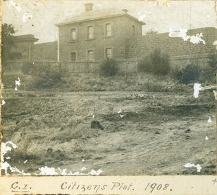
Photograph
... Street Ararat grampians Record of local history 501: Citizens Plot 1908 502: Citizens Plot 1909. 503: Citizens Plot showing growth 1921. A series of three black and white photographs of the Citizens Plot at Alexandra Gardens. 501 shows the bluestone building J Ward standing behind a wooden picket fence with bare earth in front. 502 shows men in suits standing with three horses attached to two wagons with large trees in the background. 503 shows plants that have grown in the Citizens Plot garden. ...Record of local historyA series of three black and white photographs of the Citizens Plot at Alexandra Gardens. 501 shows the bluestone building J Ward standing behind a wooden picket fence with bare earth in front. 502 shows men in suits standing with three horses attached to two wagons with large trees in the background. 503 shows plants that have grown in the Citizens Plot garden.501: Citizens Plot 1908 502: Citizens Plot 1909. 503: Citizens Plot showing growth 1921. -
Marysville & District Historical Society
THE TRIANGLE NEWS-VOL 1 NO 4-AUGUST 13 1976
... Marysville & District Historical Society 39 Darwin Street Marysville yarra-valley-and-the-dandenong-ranges marysville victoria australia ken mckenzie rainfall golf marysville and buxton district angling club carpet bowls shire of healesville tree planting scheme narbethong picnic caberet church alexandra high school community care centre motor cycle scramble football THE TRIANGLE NEWS-VOL 1 NO 4-AUGUST 13 1976 ...marysville, victoria, australia, ken mckenzie, rainfall, golf, marysville and buxton district angling club, carpet bowls, shire of healesville tree planting scheme, narbethong picnic caberet, church, alexandra high school, community care centre, motor cycle scramble, football -
Marysville & District Historical Society
THE TRIANGLE NEWS-VOL 38 NO 36-OCTOBER 7 2011
... Marysville & District Historical Society 39 Darwin Street Marysville yarra-valley-and-the-dandenong-ranges marysville victoria australia triangle trails approved by council mayor peter beales dse murrindindi shire council colourful lining to marysville streets 308 trees to be planted across town council's bushfire reconstruction and recovery unit parks victorian ranges vandalism to recent facilities sugarloaf saddle cathedral ranges state park parks victoria advertisements yea country market THE TRIANGLE NEWS-VOL 38 NO 36-OCTOBER 7 2011 ...marysville, victoria, australia, triangle trails approved by council, mayor peter beales, dse, murrindindi shire council, colourful lining to marysville streets, 308 trees to be planted across town, council's bushfire reconstruction and recovery unit, parks victorian ranges, vandalism to recent facilities, sugarloaf saddle, cathedral ranges state park, parks victoria, advertisements, yea country market -
 Orbost & District Historical Society
wooden box, McLean, Don, Just prior to January 2010
... Orbost & District Historical Society Ruskin Street Orbost gippsland This box was crafted from a portion of one of the original oak trees in the Jarrahmond WW11 Avenue of Honour.The Avenue was planted in 1955 and linked the farms of the two servicemen from Jarrahmond who lost their lives in WWII. ...This box was crafted from a portion of one of the original oak trees in the Jarrahmond WW11 Avenue of Honour.The Avenue was planted in 1955 and linked the farms of the two servicemen from Jarrahmond who lost their lives in WWII. It consisted of English Oaks interspersed with flowering peaches and cherries. Wood for the box was collected in the early 1990's by Stan Weatherall following a windstorm. Stan had the timber rough-sawn into planks by local sawmiller Max Reynolds. The timber was stored for a number of years before being given to Don McLean.A hand-made oak box. The inside base is lined in green felt. The lid is single hinged. the front panel displays a radiating pattern in the grain of the oak wood that resembles the rising sun badge of the Australian Defence Forces. Two brass pins are symbols of Australian military regalia. Inside the box is an envelope with information and letters on the manufacture of the box and presentation to Orbost. The information concerns the Jarrahmond School and the Avenue of Honour.handcraft oak jarrahmond-avenue-of-honour container -
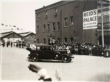 Federation University Historical Collection
Photograph, Reid's Coffee Palace, Lydiard Street, Ballarat, c1930s ?
... plant trees in the Ballarat Avenue of Honour? There is a band in the background. Note the folded back roof which allows the passenger to be seen by the public. https://architectureau.com/articles/heritage-listed-gold-rush-era-ballarat-coffee-palace-receives-700000-conservation-grant/ reid's coffee palace ballarat railway station visitor bunting celebration Ballarat Verso - Post (Correspondence) Black and white photos of a car leaving the Ballarat Station (possibly carrying William Birdwood?). Reid's Coffee Palace is in the background Reid's Coffee Palace, Lydiard Street ...The special guest in the car appears to have arrived in Ballarat by train. Could it be William Birdwood to plant trees in the Ballarat Avenue of Honour? There is a band in the background. Note the folded back roof which allows the passenger to be seen by the public. https://architectureau.com/articles/heritage-listed-gold-rush-era-ballarat-coffee-palace-receives-700000-conservation-grant/Black and white photos of a car leaving the Ballarat Station (possibly carrying William Birdwood?). Reid's Coffee Palace is in the background Verso - Post (Correspondence)reid's coffee palace, ballarat railway station, visitor, bunting, celebration, ballarat -
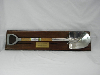 Conservation Volunteers
Memorabilia: Cyclone Sylvaspade, Australian Bicentenary 1988, Cyclone Sylvaspade - Senator Graham Richardson planted a tree using this spade at Sovereign Hill Outdoor Museum to mark ATCV's work at the Australian Bicentennial, 1988 (exact)
... Conservation Volunteers 728 Barkly Street Mount Helen goldfields The spade is a memento of the planting of a tree by the responseible Commonealth Minister to recognise the contribution of ATCV and ATCV volunteers to repair of the Australian environment. ...The spade is a memento of the planting of a tree by the responseible Commonealth Minister to recognise the contribution of ATCV and ATCV volunteers to repair of the Australian environment. At the time ATCV had been operating in Ballarat for six years. ATCV volunteers had planted 192,000 trees from April 1987- March 1988. Senator Richardson was then Minister for the Arts and the Environment in the Hawke ALP Government and on 17 November 1988 he planted a tree using this spade at Sovereign Hill Outdoor Museum (at which ATCV volunteers had planted trees which are (by 2010) fully grown and a significant feature of the site). Peter Hiscock was director of Sovereign Hill as well as President of ATCV and among the most significant leaders of ATCV (now CVA). The spade also symbolises the recovery of ATCV (then a small and struggling community group) from near closure owing to the effects of the 1987 recession. The Cyclone Sylvaspade concept was component project of the Australian Bicentennial celebrations aimed at recognising organisations which had contributed positively to conservation of Australia's environment. The concept was originated and driven by Dr Wilf Crane of the CSIRO Division of Forestry and a highly regarded forester and environmentalist and champion of the cause of rejuvenating Australia's degraded landscape with trees. At the naming of a road after him in Canberra he was described as a: "enthusiast, a man of conviction, action, humility and simplicity". Wilf conceived the project, developed the tree planting spade with Boral Cyclone and the Institute of Foresters of Australia and launched it with the then Governor-General Sir Ninian Stephens at the new Parliament House. Cyclone has been a brand name for a manufacturer of good quality hand tools for over a century. It is likely manufacturing was still done in Australia at the time of manufacture of the Sylvaspade. Much of it has now moved offshore, particuarly to China and Taiwan.This object is historically significant because it is a memento of a significant national event, the 200th anniversary of European settlement and the start of a process of environmental change which has had negative consequences and which demands a commitment to conserving the uniques Australian national environment. It recognised the achievement of ATCV in tree planting over six years. The Cyclone Sylvaspade is a practical memento and having the responsible Commonwealth Minister plant a tree with it was highly symbolic of ATCV's practical commitment to repair of our environment all over Australia. It was also used by the Victorian Premier, Hon John Brumby, to plant a tree at the reopening of the Boral Asphalt plant, Ballarat, in April 2010. The spade is No. 12 of a limited edition. This item is a functional tree planting spade called a "Cyclone Sylvaspade", mounted on a block of wood with a plaque. The handle of the spade is made of grey plastic, the haft is light, stained wood, and the blade is manufactured to resemble silver and has engravings. It was donated by the Boral company and presented to ATCV by the Minister of Arts and the Environment, Senator Graham Richardson after he had planted a tree to mark the occasion at Sovereign Hill Outdoor Museum, BallaratOn the stem of the spade here is a label showing the logo of the Boral company which reads "SYLVASPADE Tree Planting Spade - Made in Australia." On the blade is engraved "Cyclone - NUMBER 0012 - SYLVASPADE - 1788-1988" together with the logo of the Australian Bicentennial Authority. The spade is mounted on a sturdy polished wooden board on which there is a brass-coloured plate bearing the words: "PRESENTED BY SENATOR THE HON GRAHAM RICHARDSON TO AUSTRALIAN TRUST FOR CONSERVATION VOLUNTEERS IN RECOGNITION OF THEIR CONTRIBUTION TO THE ENVIRONMENT 17TH NOVEMBER 1988 DONATED BY BORAL LIMITED"of, trust, ballarat, memento, australian, australia, environment, conservation, atcv, for, volunteers, cyclone, sylvaspade, senator graham richardson, 1788 1988 australian, bicentennial, boral, spade, sovereign hill, 17th november 1988, 1988, minister for arts and environment, tree planting, institute, foresters, dr, wilf, crane -
 Ballarat and Queen's Anglican Grammar School
Badge, Noopsi Badges celebrating 100 years of Anglican education
... Streets, Wendouree was chosen carefully by the Committee set up by the Church Assembly (Synod) in November 1908. Classes began for the 38 boys enrolled on 14 February 1911. The first building accommodated 90 day boys and 25 boarders. It comprised the Headmaster’s residence, three classrooms, one large dormitory, a small bathroom, two cubicles for assistant masters and the matron’s room. During the first year the property was fenced, trees and cypress hedges were planted...Streets, Wendouree was chosen carefully by the Committee set up by the Church Assembly (Synod) in November 1908. Classes began for the 38 boys enrolled on 14 February 1911. The first building accommodated 90 day boys and 25 boarders. It comprised the Headmaster’s residence, three classrooms, one large dormitory, a small bathroom, two cubicles for assistant masters and the matron’s room. During the first year the property was fenced, trees and cypress hedges were planted ...Ballarat Grammar’s 23 acre site facing Forest and Howitt Streets, Wendouree was chosen carefully by the Committee set up by the Church Assembly (Synod) in November 1908. Classes began for the 38 boys enrolled on 14 February 1911. The first building accommodated 90 day boys and 25 boarders. It comprised the Headmaster’s residence, three classrooms, one large dormitory, a small bathroom, two cubicles for assistant masters and the matron’s room. During the first year the property was fenced, trees and cypress hedges were planted, a carriage drive was constructed and work commenced for the School Cricket Oval. Three Noopsi Badges celebrating 100 years of Anglican education at Ballarat & Queens Anglican Grammar School. These are beaded badges in blue, yellow and brown with "100" in yellow, mounted on a safety pin. "100" in worked in yellow beadsballarat, badge, queens, 100, cegs, 2011, bgs, noopsi, century-celebration, grammar-school, qceggs -
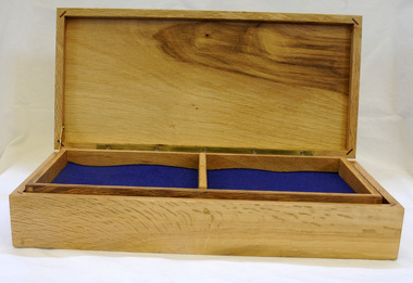
 Blacksmith's Cottage and Forge
Cake Stand, Beginning of the 20th Century
... The wood was sourced from a grove of osage orange trees in the Fisken/Taverner Street area. This grove was planted by Mr A C Simon, an orchardist, who brought the seeds from North America in the 1860's to create a protective hedge for his plants The wood from these plants produces a beautiful toned affect of dark brown and yellow/orange when turned and polished. ...Blacksmith's Cottage and Forge 100 Main Street Bacchus Marsh goldfields This cake stand was hand turned from osage orange wood. The wood was sourced from a grove of osage orange trees in the Fisken/Taverner Street area. This grove was planted ...This cake stand was hand turned from osage orange wood. The wood was sourced from a grove of osage orange trees in the Fisken/Taverner Street area. This grove was planted by Mr A C Simon, an orchardist, who brought the seeds from North America in the 1860's to create a protective hedge for his plants The wood from these plants produces a beautiful toned affect of dark brown and yellow/orange when turned and polished. The significance of this cake stand is that it has been carved from the osage orange which grows well in Bacchus Marsh although originated in America. Mr Simon made many items from this wood. This gives it local significance.This polished wooden stand would have been used for cake to be displayed It consists of a round 'plate' of wood as the top, with a fine narrow turned wood pedestal and a round base. The stand is made of osage orange giving it the unique tones of dark brown and orange wood.turned wood, osage orange, food stand, food display, brown orange wood, wooden, cake stand, parlour item, table centre piece, polished wood, ornamental stand -
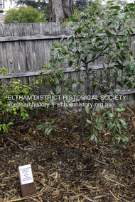 Eltham District Historical Society Inc
Photograph, Peter Pidgeon, Dedication of a Golden Wattle in memory of Harry Gilham and Sue Law, Local History Centre, 728 Main Road, Eltham, 12 April 2024
... tree was planted in memory of Eltham District Historical Society life members Harry Gilham (24 Mar 1928-25 Feb 2024; EDHS President 1993-2009) and Sue Law (27 Sep 1937-8 Aug 2023; EDHS President 1985-1993, Vice President 1993-1998 & 2009-2015). Close members of Harry’s and Sue’s families along with EDHS Committee members and life member Doug Orford joined in a dedication ceremony to commemorate their contributions, on Friday 12 April at 10.00am, in the rear yard at the Local History Centre, 728 Main Road, Eltham, on the corner of Brougham Street. ...tree was planted in memory of Eltham District Historical Society life members Harry Gilham (24 Mar 1928-25 Feb 2024; EDHS President 1993-2009) and Sue Law (27 Sep 1937-8 Aug 2023; EDHS President 1985-1993, Vice President 1993-1998 & 2009-2015). Close members of Harry’s and Sue’s families along with EDHS Committee members and life member Doug Orford joined in a dedication ceremony to commemorate their contributions, on Friday 12 April at 10.00am, in the rear yard at the Local History Centre, 728 Main Road, Eltham, on the corner of Brougham Street. ...A Golden Wattle tree was planted in memory of Eltham District Historical Society life members Harry Gilham (24 Mar 1928-25 Feb 2024; EDHS President 1993-2009) and Sue Law (27 Sep 1937-8 Aug 2023; EDHS President 1985-1993, Vice President 1993-1998 & 2009-2015). Close members of Harry’s and Sue’s families along with EDHS Committee members and life member Doug Orford joined in a dedication ceremony to commemorate their contributions, on Friday 12 April at 10.00am, in the rear yard at the Local History Centre, 728 Main Road, Eltham, on the corner of Brougham Street. EDHS President Jim Connor welcomed family members and acknowledged the dedicated efforts of both Harry and Sue over a long period of years. After unveiling of the plaque, attendees enjoyed some morning tea and sharing stories of Harry and Sue.Born Digital (15 images)activities, eltham district historical society, local history centre, main road, eltham, alison delaney, dedication, doug orford, gilham family, golden wattle, harry gilham, irene kearsey, jim connor, joan castledine, law family, peter & elizabeth pidgeon collection, plaques, richard pinn, robert marshall, russell yeoman, sue dyet, sue law -
 Eltham District Historical Society Inc
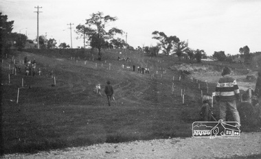
Photograph, ELTHAM ARBOR DAY 1973 - Alistair Knox with school children of the Shire of Eltham, Vic, planting native trees in the Town Park, 10 October 1973, 1973-10-10
... School children of the Shire of Eltham planting trees (previously planned to take place during the visit of Sir Rohan Delacombe to the Shire on 19th September, 1973 but cancelled that day due to inclement weather). REF: 783 SOURCE: Shire of Eltham (Eltham District Historical Society) Eltham Town Park would later be renamed Alistair Knox Park Main Road to left and Bridge Street to right - looking southeast...School children of the Shire of Eltham planting trees (previously planned to take place during the visit of Sir Rohan Delacombe to the Shire on 19th September, 1973 but cancelled that day due to inclement weather). REF: 783 SOURCE: Shire of Eltham (Eltham District Historical Society) Eltham Town Park would later be renamed Alistair Knox Park Main Road to left and Bridge Street to right - looking southeast eltham arbor day alistair knox alistair knox park eltham town park main road bridge street Black and white photograph ELTHAM ARBOR DAY 1973 - Alistair Knox with school children of the Shire of Eltham, Vic, planting native trees in the Town Park, 10 October 1973 Photograph ...ELTHAM - ARBOR DAY, 10 Oct 1973. School children of the Shire of Eltham planting trees (previously planned to take place during the visit of Sir Rohan Delacombe to the Shire on 19th September, 1973 but cancelled that day due to inclement weather). REF: 783 SOURCE: Shire of Eltham (Eltham District Historical Society) Eltham Town Park would later be renamed Alistair Knox Park Main Road to left and Bridge Street to right - looking southeastBlack and white photographeltham, arbor day, alistair knox, alistair knox park, eltham town park, main road, bridge street -
 Eltham District Historical Society Inc
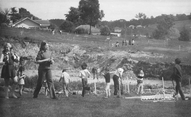
Photograph, ELTHAM ARBOR DAY 1973 - Alistair Knox with school children of the Shire of Eltham, Vic, planting native trees in the Town Park, 10 October 1973, 1973-10-10
... School children of the Shire of Eltham planting trees (previously planned to take place during the visit of Sir Rohan Delacombe to the Shire on 19th September, 1973 but cancelled that day due to inclement weather). REF: 783 SOURCE: Shire of Eltham (Eltham District Historical Society) Eltham Town Park would later be renamed Alistair Knox Park Bridge Street in background...School children of the Shire of Eltham planting trees (previously planned to take place during the visit of Sir Rohan Delacombe to the Shire on 19th September, 1973 but cancelled that day due to inclement weather). REF: 783 SOURCE: Shire of Eltham (Eltham District Historical Society) Eltham Town Park would later be renamed Alistair Knox Park Bridge Street in background eltham arbor day alistair knox alistair knox park eltham town park Black and white photograph ELTHAM ARBOR DAY 1973 - Alistair Knox with school children of the Shire of Eltham, Vic, planting native trees in the Town Park, 10 October 1973 Photograph ...ELTHAM - ARBOR DAY, 10 Oct 1973. School children of the Shire of Eltham planting trees (previously planned to take place during the visit of Sir Rohan Delacombe to the Shire on 19th September, 1973 but cancelled that day due to inclement weather). REF: 783 SOURCE: Shire of Eltham (Eltham District Historical Society) Eltham Town Park would later be renamed Alistair Knox Park Bridge Street in backgroundBlack and white photographeltham, arbor day, alistair knox, alistair knox park, eltham town park -
 Eltham District Historical Society Inc
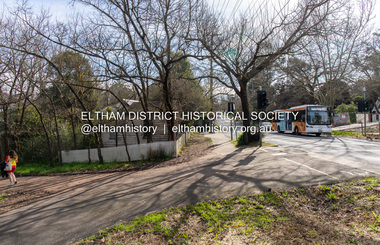
Photograph, Peter Pidgeon, Avenue of Honour, Main Road, Eltham, 2 Aug. 2022
... Street. The former Jarrold Cottage and Bootmakers shop on left. The Avenue of Honour was established in 1916-1917 by the Welcome Home Committee with the planting of over 100 trees dedicyted to the eternal memory of soldiers from the Eltham district who served in the First World War (1914-1918). ...Street. The former Jarrold Cottage and Bootmakers shop on left. The Avenue of Honour was established in 1916-1917 by the Welcome Home Committee with the planting of over 100 trees dedicyted to the eternal memory of soldiers from the Eltham district who served in the First World War (1914-1918). ...View looking up Main Road and the Avenue of Honour from opposite Dalton Street. The former Jarrold Cottage and Bootmakers shop on left. The Avenue of Honour was established in 1916-1917 by the Welcome Home Committee with the planting of over 100 trees dedicyted to the eternal memory of soldiers from the Eltham district who served in the First World War (1914-1918). Comparison photo: 00533 Part of a presentation by Peter Pidgeon to the Society, 13 August 2022 showcasing a series of photographs taken by John Henry Clark over the period 1895 to 1930. John Henry Clark was the youngest of three boys born to William Henry Clark (1823-1877) and Maria White (1843-1914). He and his brothers, William Charles Clark (1872-1945), Clement Kent Clark (1874-1912) operated a photography business (Clark Bros.) from 25 Thomas Street, Windsor near Prahran during the period c.1894 to 1914. Following death of Clement in September 1912 and their mother in 1914, the Clark Bros business appears to have dissolved, the premises demolished, and a new house was under construction in 1915. John set up business independently in 1914 operating out of 29 Moor Street, Fitzroy where he is registered in the 1914 and 1915 Electoral Rolls. By 1916 John had relocated to Eltham where he continued his practice as a photographer and took many of the early images around the district of Little Eltham. Around 1930 John changed professions and opened a small cobbler's shop in 1931 near the pond opposite Dalton Street adjacent to the Jarrold family cottage. He never married and continued his profession as a bootmaker from this little shop, maintaining a close relationship with Mrs Jarrold for the rest of their lives. His bootmaker shop remains today beside the Whitecloud cottage and is one of only three remaining shops in the area from the early 20th century.Comparative photo taken 2022 with one taken from same location over 100 years earlier by noted local photographer J.H. ClarkBorn Digitaleltham, j.h. clark photo (2022), dalton street, main road, bootmaker's shop, jarrold cottage, white cloud cottage, avenue of honour -
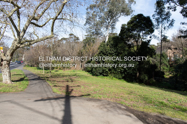
 Eltham District Historical Society Inc
Photograph, Peter Pidgeon, Avenue of Honour, Main Road, Eltham, 2 Aug. 2022
... Street. The Avenue of Honour was established in 1916-1917 by the Welcome Home Committee with the planting of over 100 trees dedicyted to the eternal memory of soldiers from the Eltham district who served in the First World War (1914-1918). ...Street. The Avenue of Honour was established in 1916-1917 by the Welcome Home Committee with the planting of over 100 trees dedicyted to the eternal memory of soldiers from the Eltham district who served in the First World War (1914-1918). ...View looking down Main Road and the Avenue of Honour from Brougham Street. The Avenue of Honour was established in 1916-1917 by the Welcome Home Committee with the planting of over 100 trees dedicyted to the eternal memory of soldiers from the Eltham district who served in the First World War (1914-1918). Comparison photo: SEPP_0748 Part of a presentation by Peter Pidgeon to the Society, 13 August 2022 showcasing a series of photographs taken by John Henry Clark over the period 1895 to 1930. John Henry Clark was the youngest of three boys born to William Henry Clark (1823-1877) and Maria White (1843-1914). He and his brothers, William Charles Clark (1872-1945), Clement Kent Clark (1874-1912) operated a photography business (Clark Bros.) from 25 Thomas Street, Windsor near Prahran during the period c.1894 to 1914. Following death of Clement in September 1912 and their mother in 1914, the Clark Bros business appears to have dissolved, the premises demolished, and a new house was under construction in 1915. John set up business independently in 1914 operating out of 29 Moor Street, Fitzroy where he is registered in the 1914 and 1915 Electoral Rolls. By 1916 John had relocated to Eltham where he continued his practice as a photographer and took many of the early images around the district of Little Eltham. Around 1930 John changed professions and opened a small cobbler's shop in 1931 near the pond opposite Dalton Street adjacent to the Jarrold family cottage. He never married and continued his profession as a bootmaker from this little shop, maintaining a close relationship with Mrs Jarrold for the rest of their lives. His bootmaker shop remains today beside the Whitecloud cottage and is one of only three remaining shops in the area from the early 20th century.Comparative photo taken 2022 with one taken from same location over 100 years earlier by noted local photographer J.H. ClarkBorn Digitaleltham, j.h. clark photo (2022), main road, avenue of honour -
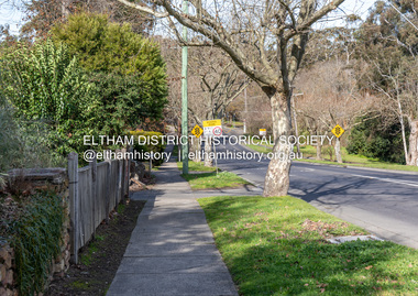
 Eltham District Historical Society Inc
Photograph, Peter Pidgeon, Avenue of Honour, Main Road, Eltham, 2 Aug. 2022
... Street. The Avenue of Honour was established in 1916-1917 by the Welcome Home Committee with the planting of over 100 trees dedicyted to the eternal memory of soldiers from the Eltham district who served in the First World War (1914-1918)....Street. The Avenue of Honour was established in 1916-1917 by the Welcome Home Committee with the planting of over 100 trees dedicyted to the eternal memory of soldiers from the Eltham district who served in the First World War (1914-1918). ...View looking down Main Road and the Avenue of Honour from near Brougham Street. The Avenue of Honour was established in 1916-1917 by the Welcome Home Committee with the planting of over 100 trees dedicyted to the eternal memory of soldiers from the Eltham district who served in the First World War (1914-1918).Born Digitaleltham, main road, avenue of honour