Showing 361 items matching " the bendigo shire"
-
 Bendigo Historical Society Inc.
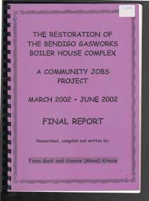
Document - THE RESTORATION OF THE BENDIGO GASWORKS BOILER HOUSE COMPLEX
... ... The Bendigo Shire...History House 11 Mackenzie Street Bendigo goldfields BUILDINGS Gas company the bendigo gasworks The Restoration of the Bendigo Gasworks Boiler House Complex Fiona Gust Simone (Mona) Krause City of Melbourne Gas and Coke Company The Bendigo Mercury The Gas and Fuel Corporation Central Deborah Community Jobs Project Peter Roberts Chrysalis Constructions CVGT Industrial Training Center Rod McLaughlin Allan Fox David Gilroy Glen Slater Aaron Ott Ron Whitford Daniel Keogh Paul Atkins Nick Pearson Leigh Williams Des Leahy Anthony Jennings Heritage Victoria The Bendigo Shire Central Deborah David Bennear David Wright Deborah Simm Community Jobs Unit James Thompson Mac Booth Mine Tramways Discovery Centre Mandy Cooper Delwyn Douglass Cindy Tassie Helen Yorston Brenda Stanley Greg O'Connell Kym Smith Darren Hutchesson Julie Cain John Bullen Joe Slaviero Mario Joh;ns Norm Harris Paul Green Len Cutting Jim Morrissy Melissa Tuddenham Fiona Beckwith Leo Trainor Gary Anquetil Helen Lynch Abbotts Supply Action Auction Garry Floyd Bendigo Trailers and Hardware - Matt Ron & Jack Brennans - Butch & Robbie Bunnings - Evan brett Crapper Hip Pocket Jason Kiel Country Victorian Scaffolding Paint Right Bendigo Alan Gladman Deborah Simms Graeme Jennings Hugh Ward Leigh Williams Paul Eccles Peter Sporn Barb & Mal Krause Peter & Shirley Turner Bendigo Copy Centre The Restoration of The Bendigo Gasworks Boiler House Complex, A Community Jobs Project March 2002 - June 2002. ...The Restoration of The Bendigo Gasworks Boiler House Complex, A Community Jobs Project March 2002 - June 2002. Final Report. Researched, compiled and written by: Fiona Gust and Simone (Mona) Krause. Front cover is purple, back cover is black and some inside pages are red or yellow. Topics in the book are: History of the Gasworks, How a Gasworks Works, Heritage Requirements, The CJP Crew, Crew Profiles, Initial Condition of the Boiler House Complex, O, H & S, Work Begins - Asbestos Removal, Clean-up, Iron Removal and Glazing. Artifact Cataloguing, where artifacts and where they were found were cataloged. On Going Discoveries. Exhauster ad Tank Room Ceilings, Pipes, Oil Spray Tower, Skillion over the Amenities Block, Posts, Beams along the Exhauster Room Wall-NE side, Beams on the SW side of the gable .. The join between the skillion and gable roof, Donuts on the Exhauster Room Wall - NE side, Trusses, Gutters and down pipes, Paint and Whitewash, Brickwork, Iron Fittings, Internal Fixtures, Generator Room/Compressor Room, Floors and Conclusion. The Captains Last Words by Peter Roberts. Acknowledgements. The coloured pages in the back are Edition One - 19.4.2002, Edition Two and Edition 3 of Combustible News which gives a progressive account of the work.buildings, gas company, the bendigo gasworks, the restoration of the bendigo gasworks boiler house complex, fiona gust, simone (mona) krause, city of melbourne gas and coke company, the bendigo mercury, the gas and fuel corporation, central deborah, community jobs project, peter roberts, chrysalis constructions, cvgt industrial training center, rod mclaughlin, allan fox, david gilroy, glen slater, aaron ott, ron whitford, daniel keogh, paul atkins, nick pearson, leigh williams, des leahy, anthony jennings, heritage victoria, the bendigo shire, central deborah, david bennear, david wright, deborah simm, community jobs unit, james thompson, mac booth, mine, tramways, discovery centre, mandy cooper, delwyn douglass, cindy tassie, helen yorston, brenda stanley, greg o'connell, kym smith, darren hutchesson, julie cain, john bullen, joe slaviero, mario joh;ns, norm harris, paul green, len cutting, jim morrissy, melissa tuddenham, fiona beckwith, leo trainor, gary anquetil, helen lynch, abbotts supply, action auction, garry floyd, bendigo trailers and hardware - matt, ron & jack, brennans - butch & robbie, bunnings - evan, brett crapper, hip pocket, jason kiel, country victorian scaffolding, paint right bendigo, alan gladman, deborah simms, graeme jennings, hugh ward, leigh williams, paul eccles, peter sporn, barb & mal krause, peter & shirley turner, bendigo copy centre -
 Bendigo Military Museum
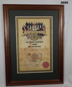
Certificate - CITIZENS OF BENDIGO, FAMED, Post WW2
... shire...bendigo...Certificates issued to returning soldiers in Bendigo Shire WW2...Bendigo Military Museum 37 - 39 Pall Mall Bendigo goldfields Certificates issued to returning soldiers in Bendigo Shire WW2 Certificate shire bendigo Printed on certificate: “TO YOU WHO SERVED 1939 - 1945. ...Certificates issued to returning soldiers in Bendigo Shire WW2Coloured certificate with Australian & Union Jack flags & 7 service members at top. Cream background featuring Pall Mall Bendigo. Tan wooden frame with glass front, white backing with wire hanging strap on back.Printed on certificate: “TO YOU WHO SERVED 1939 - 1945. THE CITIZENS OF BENDIGO EXPRESS DEEP THANKFULNESS To N J Oliver” Signed by: “Major & Town Clerk” Bottom R: “Red seal”certificate, shire, bendigo -
 Bendigo Historical Society Inc.
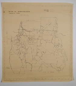
Map - CAMPBELL COLLECTION: BENDIGO AND DISTRICT MAPS, 21-8-1972
... Shire of Huntly, Shire of McIvor, City of Bendigo, Shire of Marong, Shire of Maldon, Shire of Metcalfe. ...Shire of Huntly, Shire of McIvor, City of Bendigo, Shire of Marong, Shire of Maldon, Shire of Metcalfe. ...Map. Shire of Strathfieldsaye, Locality Plan. Scale I inch=1 mile. Shire of Huntly, Shire of McIvor, City of Bendigo, Shire of Marong, Shire of Maldon, Shire of Metcalfe. Lake Eppalock. Mileage markers on some roads. Melbourne to Bendigo Railway Line, Big Hill Tunnel, Mt.Herbert 1596.Axedale Township, Strathfieldsaye Township.M.Higgs 21-8-1972map, bendigo, locality plan -
 Bendigo Historical Society Inc.
Map - CAMPBELL COLLECTION: BENDIGO AND DISTRICT MAPS, 21-8-1972
... Drawn by M.Higgs 21-8-1972, Shire of Huntly, Shire of McIvor, City of Bendigo, Shire of Marong, Shire of Maldon, Shire of Metcalfe, Lake Eppalock, Axedale Township, Strathfieldsaye Township, Melbourne to Bendigo Railway Line, Big Hill Tunnel, Mt.Herbert 1596. ...Drawn by M.Higgs 21-8-1972, Shire of Huntly, Shire of McIvor, City of Bendigo, Shire of Marong, Shire of Maldon, Shire of Metcalfe, Lake Eppalock, Axedale Township, Strathfieldsaye Township, Melbourne to Bendigo Railway Line, Big Hill Tunnel, Mt.Herbert 1596. ...Map. Shire of Strathfieldsaye Locality Plan. Scale 1 inch=1 mile. Drawn by M.Higgs 21-8-1972, Shire of Huntly, Shire of McIvor, City of Bendigo, Shire of Marong, Shire of Maldon, Shire of Metcalfe, Lake Eppalock, Axedale Township, Strathfieldsaye Township, Melbourne to Bendigo Railway Line, Big Hill Tunnel, Mt.Herbert 1596. (number 398 in map cupboard 1)M.Higgs 21-8-1972map, bendigo, locality plan -
 Bendigo Historical Society Inc.
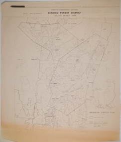
Map - CAMPBELL COLLECTION: BENDIGO AND DISTRICT MAPS, 1982
... Forest Commission Victoria, Bendigo Forest District, Greater Bendigo Area. Shire of Marong, Sailors Gully, Epsom, Borough of Eaglehawk, Jackass Flat, White Hills, California Gully, Shire of Huntly, Maiden Gully, Long Gully, North Bendigo, Bendigo East, City of Bendigo, West Bendigo, Kennington, Shire of Strathfieldsaye, Flora Hill, Quarry Hill, Golden Square, Kangaroo Flat, Spring Gully. ...Forest Commission Victoria, Bendigo Forest District, Greater Bendigo Area. Shire of Marong, Sailors Gully, Epsom, Borough of Eaglehawk, Jackass Flat, White Hills, California Gully, Shire of Huntly, Maiden Gully, Long Gully, North Bendigo, Bendigo East, City of Bendigo, West Bendigo, Kennington, Shire of Strathfieldsaye, Flora Hill, Quarry Hill, Golden Square, Kangaroo Flat, Spring Gully. ...Map. Forest Commission Victoria, Bendigo Forest District, Greater Bendigo Area. Shire of Marong, Sailors Gully, Epsom, Borough of Eaglehawk, Jackass Flat, White Hills, California Gully, Shire of Huntly, Maiden Gully, Long Gully, North Bendigo, Bendigo East, City of Bendigo, West Bendigo, Kennington, Shire of Strathfieldsaye, Flora Hill, Quarry Hill, Golden Square, Kangaroo Flat, Spring Gully. Prevention Strategy Plan. Base prepared 1982.map, bendigo, forest district -
 Bendigo Historical Society Inc.
Document - UBD DETAILED REFERENCE MAP - CITY OF BENDIGO
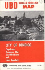
... Universal Business Directories Publication UBD Detailed Reference Map - City of Bendigo Eaglehawk, Kangaroo Flat Strathfieldsaye and Lake Eppalock Single page folded map sheet providing three maps: * Bendigo, Eaglehak & Shire of Strathfieldsaye on main sheet * Eppalock & Environs * Kangaroo Flat hand written date June 1975, and 50 cents cost...History House 11 Mackenzie Street Bendigo goldfields Universal Business Directories Publication Universal Business Directories Publication UBD Detailed Reference Map - City of Bendigo Eaglehawk, Kangaroo Flat Strathfieldsaye and Lake Eppalock Single page folded map sheet providing three maps: * Bendigo, Eaglehak & Shire of Strathfieldsaye on main sheet * Eppalock & Environs * Kangaroo Flat hand written date June 1975, and 50 cents cost Document UBD DETAILED REFERENCE MAP - CITY OF BENDIGO ...Universal Business Directories Publication UBD Detailed Reference Map - City of Bendigo Eaglehawk, Kangaroo Flat Strathfieldsaye and Lake Eppalock Single page folded map sheet providing three maps: * Bendigo, Eaglehak & Shire of Strathfieldsaye on main sheet * Eppalock & Environs * Kangaroo Flat hand written date June 1975, and 50 cents costUniversal Business Directories Publication -
 City of Greater Bendigo - Civic Collection
Photograph - Strathfieldsaye Councillor Group Portrait, D.G. Coope & Son - Framers
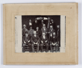
... It remained a shire until amalgamation in 1994 when it became part of the City of Greater Bendigo. ...It remained a shire until amalgamation in 1994 when it became part of the City of Greater Bendigo. ...The district of Strathfieldsaye was proclaimed in 1861 and named a Shire on the 17th September in 1866. It remained a shire until amalgamation in 1994 when it became part of the City of Greater Bendigo. The shire was located 8 km to the south- east of Bendigo and covered an area of 601 square kilometres and extended from the Calder Highway to the Coliban and Campaspe Rivers. The shire's administration centre was in Strathfieldsaye until 1972 when new offices were opened in Kennington.Silver gelatin framed photographic group portrait of fifteen men taken in the alcove of the Strathfieldsaye Shire Hall. Four men are seated and eleven are standing. Photograph is attached directly to cream mount card. Handwritten note with photograph: 1/ John Burke, 2/ (?), 3/ (?), 4/ RHS Abbott, 5/ M Brennan, 6/(?) 7/(?) 1/. M Condon? 2/ (?) 3/ M Burns, 4/(?) Gentlemen at back are probably council staff.shire of strathfieldsaye, strathfieldsaye shire council, president of strathfieldsaye shire, councillor john burke, councillor r.h.s. abbott, councillor brennan, councillor condon, councillor m burns -
 City of Greater Bendigo - Civic Collection
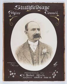
Photograph - Portrait of Councillor Keck, W H Robinson, c 1913
... It remained a shire until amalgamation in 1994 when it became part of the City of Greater Bendigo. ...Strathfieldsaye / Shire Council / W.H. Robinson / Photo / Bendigo / J.H.E Gribbs / Presented by / Cr Herbert Keck / President 1903-4. 1912-13....It remained a shire until amalgamation in 1994 when it became part of the City of Greater Bendigo. ...The district of Strathfieldsaye was proclaimed in 1861 and named a Shire on the 17th September in 1866. It remained a shire until amalgamation in 1994 when it became part of the City of Greater Bendigo. The shire was located 8 km to the south- east of Bendigo and covered an area of 601 square kilometres and extended from the Calder Highway to the Coliban and Campaspe Rivers. The shire's administration centre was in Strathfieldsaye until 1972 when new offices were opened in Kennington.Framed black and white head and shoulder portrait of Councillor Keck with hand coloured and drawn detail. Profile slightly to right with walrus moustache. Cut oval brown mount decorated with text and flowers. Hand written title top and lower centre.Strathfieldsaye / Shire Council / W.H. Robinson / Photo / Bendigo / J.H.E Gribbs / Presented by / Cr Herbert Keck / President 1903-4. 1912-13.shire of strathfieldsaye, councillor keck, strathfieldsaye shire council, president of strathfieldsaye shire -
 City of Greater Bendigo - Civic Collection
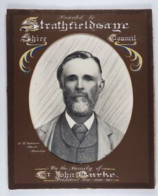
Photograph - Portrait of Councillor Burke
... It remained a shire until amalgamation in 1994 when it became part of the City of Greater Bendigo. ...Presented to Strathfieldsaye / shire Council / w. H. robinson / Photo / Bendigo / By the family of / Cr John Burke / President 1890 - 1899 - 1900...It remained a shire until amalgamation in 1994 when it became part of the City of Greater Bendigo. ...The district of Strathfieldsaye was proclaimed in 1861 and named a Shire on the 17th September in 1866. It remained a shire until amalgamation in 1994 when it became part of the City of Greater Bendigo. The shire was located 8 km to the south- east of Bendigo and covered an area of 601 square kilometres and extended from the Calder Highway to the Coliban and Campaspe Rivers. The shire's administration centre was in Strathfieldsaye until 1972 when new offices were opened in Kennington. Framed black and white head and shoulder portrait of Councillor Burke with hand coloured and drawn detail. Profile centre facing with beard. Cut oval brown mount decorated with text and fscrolls. Hand written title top and lower centre. Wooden frame with detail and gold inner.Presented to Strathfieldsaye / shire Council / w. H. robinson / Photo / Bendigo / By the family of / Cr John Burke / President 1890 - 1899 - 1900strathfieldsaye shire council, councillor burke, president of strathfieldsaye shire -
 City of Greater Bendigo - Civic Collection
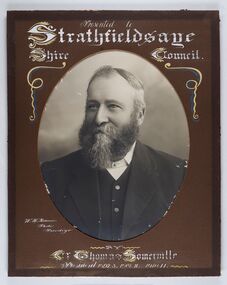
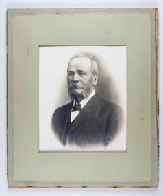
Photograph - Portrait of Councillor Thomas Somerville, W H Robinson
... It remained a shire until amalgamation in 1994 when it became part of the City of Greater Bendigo. ...Presented to / Strathfieldsaye / Shire Council / W. H. Robinson / Photo / Bendigo / by / Cr Thomas Somerville / President 1892 - 3. 1901.2. 1910.11 ...It remained a shire until amalgamation in 1994 when it became part of the City of Greater Bendigo. ...The district of Strathfieldsaye was proclaimed in 1861 and named a Shire on the 17th September in 1866. It remained a shire until amalgamation in 1994 when it became part of the City of Greater Bendigo. The shire was located 8 km to the south- east of Bendigo and covered an area of 601 square kilometres and extended from the Calder Highway to the Coliban and Campaspe Rivers. The shire's administration centre was in Strathfieldsaye until 1972 when new offices were opened in KenningtonFramed black and white head and shoulder portrait of Councillor Somerville with hand drawn detail. Profile slightly to left, face has full beard. Cut oval brown mount decorated with text and scrolls. Hand written title top and lower centre.Presented to / Strathfieldsaye / Shire Council / W. H. Robinson / Photo / Bendigo / by / Cr Thomas Somerville / President 1892 - 3. 1901.2. 1910.11 strathfieldsaye shire council, councillor somerville, president of strathfieldsaye shire -
 City of Greater Bendigo - Civic Collection
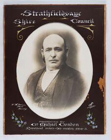
Photograph - Portrait of Councillor Michael Condon, W H Robinson
... It remained a shire until amalgamation in 1994 when it became part of the City of Greater Bendigo. ...Strathfieldsaye / Shire / Council / W. H. Robinson / Photo / Bendigo / JMB Gribble / Presented by / Cr Michael Condon / President 1889 - 90. 1895-6. 1904 - 5...It remained a shire until amalgamation in 1994 when it became part of the City of Greater Bendigo. ...The district of Strathfieldsaye was proclaimed in 1861 and named a Shire on the 17th September in 1866. It remained a shire until amalgamation in 1994 when it became part of the City of Greater Bendigo. The shire was located 8 km to the south- east of Bendigo and covered an area of 601 square kilometres and extended from the Calder Highway to the Coliban and Campaspe Rivers. The shire's administration centre was in Strathfieldsaye until 1972 when new offices were opened in KenningtonFramed black and white head and shoulder portrait of Councillor Condon with hand coloured and drawn detail. Profile slightly to left. No facial hair. Cut oval brown mount decorated with text, scrolls and flowers. Hand written title top and lower centre.Strathfieldsaye / Shire / Council / W. H. Robinson / Photo / Bendigo / JMB Gribble / Presented by / Cr Michael Condon / President 1889 - 90. 1895-6. 1904 - 5strathfieldsaye shire council, president of strathfieldsaye shire, councillor condon -
 City of Greater Bendigo - Civic Collection
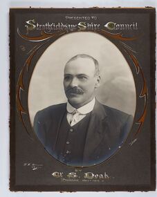
Photograph - Portrait of Councillor Doak, W H Robinson
... It remained a shire until amalgamation in 1994 when it became part of the City of Greater Bendigo. ...It remained a shire until amalgamation in 1994 when it became part of the City of Greater Bendigo. ...The district of Strathfieldsaye was proclaimed in 1861 and named a Shire on the 17th September in 1866. It remained a shire until amalgamation in 1994 when it became part of the City of Greater Bendigo. The shire was located 8 km to the south- east of Bendigo and covered an area of 601 square kilometres and extended from the Calder Highway to the Coliban and Campaspe Rivers. The shire's administration centre was in Strathfieldsaye until 1972 when new offices were opened in Kennington.Framed black and white head and shoulder portrait of Councillor Doak with hand coloured and drawn detail. Left facing profile with walrus moustache. Cut oval brown mount decorated with text and scrolls. Hand written title top and lower centre.Presented to / Strathfieldsaye Shire Council / W. H. Robinson / Photo / JMB Gribble / by Cr S. Doak / President 1911 - 1912strathfieldsaye shire council, president of strathfieldsaye shire, councillor doak -
 City of Greater Bendigo - Civic Collection
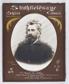
Photograph - Portrait of Councillor Sibley, W H Robinson
... It remained a shire until amalgamation in 1994 when it became part of the City of Greater Bendigo. ...Strathfieldsaye / Shire Council / W m Robinson / Photo / Bendigo / J N B Gribble / Cr Robert R Sibley / First President Chairman of the Road Board 1865 - 5 / President 1866 - 1869 / With Mrs Sibley's Compliments...It remained a shire until amalgamation in 1994 when it became part of the City of Greater Bendigo. ...The district of Strathfieldsaye was proclaimed in 1861 and named a Shire on the 17th September in 1866. It remained a shire until amalgamation in 1994 when it became part of the City of Greater Bendigo. The shire was located 8 km to the south- east of Bendigo and covered an area of 601 square kilometres and extended from the Calder Highway to the Coliban and Campaspe Rivers. The shire's administration centre was in Strathfieldsaye until 1972 when new offices were opened in KenningtonFramed black and white head and shoulder portrait of Councillor Sibley with hand coloured and drawn detail. Profile slightly to left with walrus moustache and beard. Cut oval brown mount decorated with text, flowers and scrolls. Hand written title top and lower centre.Strathfieldsaye / Shire Council / W m Robinson / Photo / Bendigo / J N B Gribble / Cr Robert R Sibley / First President Chairman of the Road Board 1865 - 5 / President 1866 - 1869 / With Mrs Sibley's Complimentsstrathfieldsaye shire council, councillor sibley, president of strathfieldsaye shire -
 City of Greater Bendigo - Civic Collection
Photograph - Portrait of Councillor Long, Talma & Co
... It remained a shire until amalgamation in 1994 when it became part of the City of Greater Bendigo. ...It remained a shire until amalgamation in 1994 when it became part of the City of Greater Bendigo. ...The district of Strathfieldsaye was proclaimed in 1861 and named a Shire on the 17th September in 1866. It remained a shire until amalgamation in 1994 when it became part of the City of Greater Bendigo. The shire was located 8 km to the south- east of Bendigo and covered an area of 601 square kilometres and extended from the Calder Highway to the Coliban and Campaspe Rivers. The shire's administration centre was in Strathfieldsaye until 1972 when new offices were opened in Kennington.Framed black and white head and shoulder portrait of Councillor Long. Profile to left with walrus moustache and mutton chops. Cut olive retangle mount. Verso; Long. On under board which has photograph attached; Talma & Co. / 119 Swanston St., / Melbournestrathfieldsaye shire council, councillor long -
 City of Greater Bendigo - Civic Collection
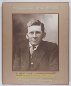
Photograph - Portrait of Councillor Hargraves, Bartlett Bros
... It remained a shire until amalgamation in 1994 when it became part of the City of Greater Bendigo. ...It remained a shire until amalgamation in 1994 when it became part of the City of Greater Bendigo. ...The district of Strathfieldsaye was proclaimed in 1861 and named a Shire on the 17th September in 1866. It remained a shire until amalgamation in 1994 when it became part of the City of Greater Bendigo. The shire was located 8 km to the south- east of Bendigo and covered an area of 601 square kilometres and extended from the Calder Highway to the Coliban and Campaspe Rivers. The shire's administration centre was in Strathfieldsaye until 1972 when new offices were opened in KenningtonFramed black and white head and shoulder portrait of Councillor Hargraves. Profile slightly to right with walrus moustache. Cut rectangle brown mount decorated with coloured text and scrolls. Hand written title top and lower centre.Strathfiledsaye Shire Council / Cr John Hargreaves / President 1919 - 20 1928 - 29 / Presented by his Wife & Familystrathfieldsaye shire council, president of strathfieldsaye shire, councillor hargreaves -
 City of Greater Bendigo - Civic Collection
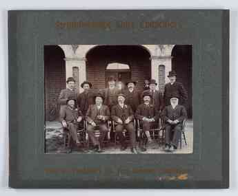
Photograph - Councillor group portrait, W H Robinson, Strathfieldsaye Shire Council, 1909
... It remained a shire until amalgamation in 1994 when it became part of the City of Greater Bendigo. ...Shire Councillors / R. B. Brennan (Sec.) W. J. Lowdes S. Doak M. Burns () N Condon B. Code (Inspector) / WH Robinson Photo Bendigo / T Somerville / W. ...It remained a shire until amalgamation in 1994 when it became part of the City of Greater Bendigo. ...The district of Strathfieldsaye was proclaimed in 1861 and named a Shire on the 17th September in 1866. It remained a shire until amalgamation in 1994 when it became part of the City of Greater Bendigo. The shire was located 8 km to the south- east of Bendigo and covered an area of 601 square kilometres and extended from the Calder Highway to the Coliban and Campaspe Rivers. The shire's administration centre was in Strathfieldsaye until 1972 when new offices were opened in Kennington.Photographic group portrait of eleven Strathfieldsaye Shire Councillors in front of the Strathfieldsaye Shire Hall. Five men are seated and six standing with one man standing further in back ground on the building's verandah. Photograph is attached directly to green mount card and framed. Gold lettering on mount.Strathfieldsaye Shire Councillors / R. B. Brennan (Sec.) W. J. Lowdes S. Doak M. Burns () N Condon B. Code (Inspector) / WH Robinson Photo Bendigo / T Somerville / W. I. Long / Fred Osborne (President) H Keck / W Dresler / With the President's (Cr. Fred Osborne) Compliments / September 23rd, 1909shire of strathfieldsaye, strathfieldsaye shire council, president of strathfieldsaye shire, strathfieldsaye shire hall -
 City of Greater Bendigo - Civic Collection
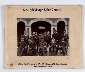
Photograph - Councillor group portrait, W H Robinson, Strathfieldsaye Shire Council
... It remained a shire until amalgamation in 1994 when it became part of the City of Greater Bendigo. ...Shire Council. / With the President's (Cr T. Somerville) Compliments. / September, 1910 / W.H. Robinson Photo. Bendigo...It remained a shire until amalgamation in 1994 when it became part of the City of Greater Bendigo. ...The district of Strathfieldsaye was proclaimed in 1861 and named a Shire on the 17th September in 1866. It remained a shire until amalgamation in 1994 when it became part of the City of Greater Bendigo. The shire was located 8 km to the south- east of Bendigo and covered an area of 601 square kilometres and extended from the Calder Highway to the Coliban and Campaspe Rivers. The shire's administration centre was in Strathfieldsaye until 1972 when new offices were opened in Kennington. Group portrait of 13 men / councilors, 5 seated and 8 standing dressed in suits. There are another 2 men further back in front of the hall doors. Photograph is taken outside the Strathfieldsaye Shire Hall.Srathfieldsaye Shire Council. / With the President's (Cr T. Somerville) Compliments. / September, 1910 / W.H. Robinson Photo. Bendigo Verso; William Drechslershire of strathfieldsaye, president of strathfieldsaye shire, strathfieldsaye shire council -
 City of Greater Bendigo - Civic Collection
Sign - Shire of Strathfieldsaye Coat of Arms
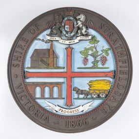
... Shire of Strathfieldsaye...City of Greater Bendigo...It remained a shire until amalgamation in 1994 when it became part of the City of Greater Bendigo. ...It remained a shire until amalgamation in 1994 when it became part of the City of Greater Bendigo. ...The district of Strathfieldsaye was proclaimed in 1861 and named a Shire on the 17th September in 1866. It remained a shire until amalgamation in 1994 when it became part of the City of Greater Bendigo. The shire was located 8 km to the south- east of Bendigo and covered an area of 601 square kilometres and extended from the Calder Highway to the Coliban and Campaspe Rivers. The shire's administration centre was in Strathfieldsaye until 1972 when new offices were opened in Kennington. This coat of arms was commissioned for the front of the shire hall building.Brass painted coat of arms or emblem within a circle of the Shire of Strathfieldsaye. Outer rim contains text: SHIRE OF STRATHFIELDSAYE VICTORIA 1866 with the shield of the monarch of the United Kingdom centre top. The shield is divided into four parts with images reflecting the leading industries of the time; wine growing, mining, farming and tanning. The motto PROGRESS is depicted lower centre of shield. SHIRE OF STRATHFIELDSAYE / VICTORIA / 1866 / PROGRESSshire of strathfieldsaye, city of greater bendigo amalgamation, city of greater bendigo signs -
Bendigo Historical Society Inc.
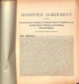
Document - BASIL MILLER COLLECTION: TRAMS - CONSTRUCTION MODIFIED AGREEMENT
... Re: construction of Tramway in Bendigo Eaglehawk, and Marong Shire....Re: construction of Tramway in Bendigo Eaglehawk, and Marong Shire. Document BASIL MILLER COLLECTION: TRAMS - CONSTRUCTION MODIFIED AGREEMENT ...Printed copy of Modified Agreement between City Council of Bendigo, Borough of Eaglehawk and Shire of Marong and the Sandhurst and Eaglehawk Electric Tramway Company Ltd. Re: construction of Tramway in Bendigo Eaglehawk, and Marong Shire.Carl Kneebone on frontperson, individual, basil miller -
 City of Greater Bendigo - Civic Collection
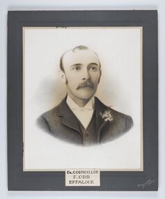
Photograph - Portrait of Councillor Orr, The Yeoman Studios, Ex. Councillor / F. Orr / Eppalock
... It remained a shire until amalgamation in 1994 when it became part of the City of Greater Bendigo. ...It remained a shire until amalgamation in 1994 when it became part of the City of Greater Bendigo. ...The district of Strathfieldsaye was proclaimed in 1861 and named a Shire on the 17th September in 1866. It remained a shire until amalgamation in 1994 when it became part of the City of Greater Bendigo. The shire was located 8 km to the south- east of Bendigo and covered an area of 601 square kilometres and extended from the Calder Highway to the Coliban and Campaspe Rivers. The shire's administration centre was in Strathfieldsaye until 1972 when new offices were opened in Kennington. Eppalock Ward is one of three wards in the Greater Bendigo municipality which includes the former Strathfieldsaye Shire. Framed black and white head and shoulder portrait with hand coloured detail. Man with profile slightly to right, walrus moustache, image encircled. Photograph is attached to mount card. Hand written title lower centre.Ex. Councillor / F. Orr / Eppalock / The / Yeoman / Studiosshire of strathfieldsaye, councillor orr -
 City of Greater Bendigo - Civic Collection
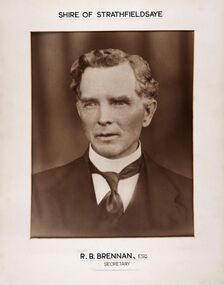
Photograph - Portrait of Shire Secretary Brennan, Unknown
... It remained a shire until amalgamation in 1994 when it became part of the City of Greater Bendigo. ...It remained a shire until amalgamation in 1994 when it became part of the City of Greater Bendigo. ...The district of Strathfieldsaye was proclaimed in 1861 and named a Shire on the 17th September in 1866. It remained a shire until amalgamation in 1994 when it became part of the City of Greater Bendigo. The Shire was located 8 km to the south- east of Bendigo and covered an area of 601 square kilometres and extended from the Calder Highway to the Coliban and Campaspe Rivers. The shire's administration centre was in Strathfieldsaye until 1972 when new offices were opened in Kennington. Secretary Brennan, son of Councillor M. Brennan was appointed after his fathers death to the role and according to the The Bendigo Independent was in the role in 1917. See References.Framed black and white head and shoulder portrait of Councillor Brennan. Profile slightly to left. Cut rectangle cream mount. Hand written title top and lower centre. Shire of Strathfieldsaye / R. B. Brennan, Esq / Secretarystrathfieldsaye shire council, secretary strathfieldsaye shire -
 Bendigo Historical Society Inc.
Booklet - Bendigo Tramways Agreement between City of Bendigo, Borough of Eaglehawk, Shire of Marong and Bendigo Tramway Company
... Bendigo Tramways Agreement between City of Bendigo, Borough of Eaglehawk, Shire of Marong and Bendigo Tramway Company...Shire...City Council of Bendigo...Booklet concerning Modified Agreement between City of Bendigo, Borough of Eaglehawk, Shire of Marong and Bendigo Tramway Company. ...Booklet Bendigo Tramways Agreement between City of Bendigo, Borough of Eaglehawk, Shire of Marong and Bendigo Tramway Company ...The Sandhurst and Electric Tramway Company was the first to blaze a trail when it introduced battery trams to Bendigo in June 1890. Unfortunately they had made a serious miscalculation, as the batteries quickly proved inadequate for the hilly terrain of Bendigo. After a couple of months battery trams ceased running and were later replaced by steam trams in February 1892. Steam trams were a reliable means of transport and successfully moved Bendigonians around for ten years, but the onset of the recession forced the Bendigo Tramways Company to sell up in 1899 to the Electric Supply Company of Victoria (ESCo) who continued to run steam trams until 1902. This turn-of-the-century sale led to the introduction of electric trams to Bendigo in April 1903. These were a success from the very beginning. During peak hour people would be standing in the aisles, in the doorways, even on the running boards on the outside of the tram. In addition, the trams were also the first option for deliveries. Parcels, newspapers, movie reels for the picture theatres and even mail bags found their way onto the trams; sent from outlying post offices to the GPO in the city centre. At the end of World War I the Victorian Government constituted the new semi-government instrumentality, the State Electricity Commission of Victoria (SEC). The SEC was to take over all privately owned power generating companies in Victoria and operate as a state owned monopoly ... Bendigo's tramway system was an integral part of the deal. The outbreak of World War II was a testing time. Revenue and passenger numbers were declining as automobiles became more popular. Additionally, shortages in manpower and materials due to wartime economies caused difficulties. As a result, the SEC made several attempts at closing the tramways and handing over the passenger services to private bus operators. It took some time, but in July 1970 the Victorian Parliament finally granted the SEC's application for abandonment of the tramways. April 1972 marked the closure of the Bendigo Tramways as a commuter service and an estimated 20,000 people gathered to say an emotional farewell.Booklet concerning Modified Agreement between City of Bendigo, Borough of Eaglehawk, Shire of Marong and Bendigo Tramway Company. Lime green paper cover without any text. Five pages. Agreement made September, 1891. Stapled at the spine to join cover and pages together. marong shire, city council of bendigo, council of bendigo, bendigo tramway company -
 City of Greater Bendigo - Civic Collection
Photograph - Strathfieldsaye Shire Hall
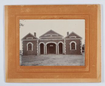
... It remained a shire until amalgamation in 1994 when it became part of the City of Greater Bendigo. ...It remained a shire until amalgamation in 1994 when it became part of the City of Greater Bendigo. ...The district of Strathfieldsaye was proclaimed in 1861 and named a Shire on the 17th September in 1866. It remained a shire until amalgamation in 1994 when it became part of the City of Greater Bendigo. The shire was located 8 km to the south- east of Bendigo and covered an area of 601 square kilometres and extended from the Calder Highway to the Coliban and Campaspe Rivers. The shire's administration activities were centred at the Strathfieldsaye Shire Hall which was built in 1869 at a cost of £700 based on a design by George Steane, the shire surveyor and built by George Pallett of Sandhurst. Constructed of red brick, the hall has a unique ventilation system with hollow walls open at the top and bottom to ensure a draught to cool the building in summer. Framed and mounted photograph of the Strathfieldsaye Shire Hall. Verso; W M Robinson / Photographer / Mundy Street Bendigostrathfieldsaye shire hall, shire of strathfieldsaye, strathfieldsaye shire council -
 City of Greater Bendigo - Civic Collection
Photograph - Portrait of Councillor Brennan, W H Robinson
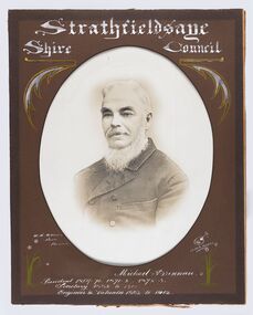
... It remained a shire until amalgamation in 1994 when it became part of the City of Greater Bendigo. ...Strathfieldsaye / Shire Council / W H Robinson / Photo / Bendigo / J H B Gribble / Michael Brennan / President 1869 - 70. 1871 - 2. 1872 - 3 / Secretary 1882 to 1900 / Engineer & Valuator 1882 to 1902...It remained a shire until amalgamation in 1994 when it became part of the City of Greater Bendigo. ...The district of Strathfieldsaye was proclaimed in 1861 and named a Shire on the 17th September in 1866. It remained a shire until amalgamation in 1994 when it became part of the City of Greater Bendigo. The shire was located 8 km to the south- east of Bendigo and covered an area of 601 square kilometres and extended from the Calder Highway to the Coliban and Campaspe Rivers. The shire's administration centre was in Strathfieldsaye until 1972 when new offices were opened in Kennington. Councillor Michael Brennan held roles of Shire Secretary and Clark of Works until around 1998 when his son R. B. Brennan was appointed Assistant Secretary and then Shire Secretary to assist his father with the work load during his later years. Michael Brennan remained Clerk of Works until his death at which time his son was appointed to the duties previously held by his father. Framed black and white head and shoulder portrait of Councillor Brennan with hand coloured and drawn detail. Profile to left. Cut oval brown mount decorated with text and flowers. Hand written title top and lower centreStrathfieldsaye / Shire Council / W H Robinson / Photo / Bendigo / J H B Gribble / Michael Brennan / President 1869 - 70. 1871 - 2. 1872 - 3 / Secretary 1882 to 1900 / Engineer & Valuator 1882 to 1902strathfieldsaye shire council, councillor brennan, president of strathfieldsaye shire -
 Bendigo Historical Society Inc.
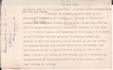
Document - NORMAN OLIVER COLLECTION: SPEECH NOTES 16 MAY 1`951
... Bendigo - 1950-51, 1964-65, 1970-71. Nineteen typed pages, 1-20 with no page 8. On the left hand margin is written in ink 'Please return to ? John? Hargreaves St'. Notes are dated 16 May 1951 and are in the format he used for his weekly talk on 3BO 'The Mayor Speaks'. Topics include : a crossing in Carpenter St, annexation of part of Strathfieldsaye Shire...Bendigo - 1950-51, 1964-65, 1970-71. Nineteen typed pages, 1-20 with no page 8. On the left hand margin is written in ink 'Please return to ? John? Hargreaves St'. Notes are dated 16 May 1951 and are in the format he used for his weekly talk on 3BO 'The Mayor Speaks'. Topics include : a crossing in Carpenter St, annexation of part of Strathfieldsaye Shire ...The Norman Oliver collection. Norman Oliver was three times Mayor of Bendigo - 1950-51, 1964-65, 1970-71. Nineteen typed pages, 1-20 with no page 8. On the left hand margin is written in ink 'Please return to ? John? Hargreaves St'. Notes are dated 16 May 1951 and are in the format he used for his weekly talk on 3BO 'The Mayor Speaks'. Topics include : a crossing in Carpenter St, annexation of part of Strathfieldsaye Shire to Bendigo, shortage of engineers and materials, White Hills swimming pool, Showgrounds conveniences, the Kindergarten, Upper Reserve and school sports, Subdivisions and separate rating, the Centenary train, visit of General Berryman, and the recruiting convoy.bendigo, council, speech notes, norman joseph oliver , councillor norman oliver. mayor. 3bo 'the mayor speaks'. bendigo centenary 1951. -
 City of Greater Bendigo - Civic Collection
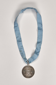
Ceremonial object - Shire of Huntly Medallion
... Shire of Huntly...City of Greater Bendigo Ceremonial item...The Midland Highway and railway line (1864) running north-east through the shire connected Goornong and Elmore to Bendigo. Elmore was the shire’s largest town, situated in a wheat/sheep farming area. ...Shire of Huntly City of Greater Bendigo Ceremonial item Front; SHIRE OF HUNGLY / 1886 / UNITA FORTIOR. ...Huntly Shire (1866-1994), north of Bendigo, was proclaimed on 13 July 1866, the successor to a road district which had been created in 1861. It was named after the Huntly parish (1854) which was probably named after Huntly, Aberdeenshire, Scotland. The shire’s south-west corner adjoined Epsom (Bendigo), its eastern boundary was the Campaspe River and its northern boundary ran through Diggora West. Its area was 878 sq km, unchanged since the shire was created. The administrative centre of the shire was Huntly, nearly on the edge of Bendigo’s urban fringe. In the south of the shire there were former gold mining areas at Huntly, Fosterville and Bagshot. The Midland Highway and railway line (1864) running north-east through the shire connected Goornong and Elmore to Bendigo. Elmore was the shire’s largest town, situated in a wheat/sheep farming area. The Kamerooka State Park was in the north-west of the shire. It was amalgamated with Bendigo, Marong, Eaglehawk and Strathfieldsaye in 1994 and is now part of the City of Greater Bendigo.Shire of Huntly stirling silver hand engraved drop suspended from a ling blue masonic ribbon. Front; SHIRE OF HUNGLY / 1886 / UNITA FORTIOR. Verso; PRESENTED TO THE SHIRE OF HUNTLY / BY CR. THE HON. M. A. CLARKE / 12TH AUGUST 1981shire of huntly, city of greater bendigo ceremonial item -
 Eltham District Historical Society Inc
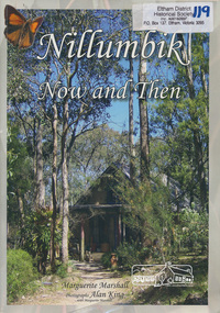
Book, Marguerite Marshall, Nillumbik now and then / Marguerite Marshall; photographs Alan King with Marguerite Marshall, 2008
... Shire - Historic Buildings and Places". Many years later an expanded version was published under the title "Nillumbik Now and Then". This is a much larger version of "Nillumbik Now and Then", including significant rewriting and many additional articles. The new publication was made possible by financial support from the Victorian Public Records Office, Bendigo...Shire - Historic Buildings and Places". Many years later an expanded version was published under the title "Nillumbik Now and Then". This is a much larger version of "Nillumbik Now and Then", including significant rewriting and many additional articles. The new publication was made possible by financial support from the Victorian Public Records Office, Bendigo ...Nillumbik Now and Then takes the reader on a journey from when the Aboriginal people were this area's sole inhabitnats, to the present day. Nillumbik's history - told in this collection of 96 stories, which are nearly all based on sites - mirrors those of the wider Australian community. It includes tales of the Wurundjeri people, a former convict, farmers, a bushranger, gold-mining, soldiers, artists, intellectuals, environmentalists and sportspeople. Each story is illustrated with a photograph. As a journalist with the former Diamond Valley News, Marguerite Marshall wrote a series of articles on local places of historic interest, later published as the small book "Eltham Shire - Historic Buildings and Places". Many years later an expanded version was published under the title "Nillumbik Now and Then". This is a much larger version of "Nillumbik Now and Then", including significant rewriting and many additional articles. The new publication was made possible by financial support from the Victorian Public Records Office, Bendigo Bank and Nillumbik Shire Council. EDHS and other historical societies in Nillumbik assisted with content for many of the stories. The book was launched at the Eltham Library on Wednesday 19th November 2008. Source: EDHS Newsletter No 183, November 2009 The front cover art depicts The former house of naturalist and artist Neil Douglas at Bend of Islands, photographer Marguerite Marshall. This collection of almost 130 photos and stories about places and people within the Shire of Nillumbik, an urban and rural municipality in Melbourne's north, contributes to an understanding of the history of the Shire. Published in 2008 immediately prior to the Black Saturday bushfires of February 7 2009, it documents sites that were impacted, and in some cases destroyed by the fires. It includes photographs taken especially for the publication, creating a unique time capsule representing the Shire in the early 21st century. It remains the most recent comprehenesive publication devoted to the Shire's history connecting local residents to the past. Paperback; x, 198 p. : ill., ports. ; 30 cm.Signed by the authornillumbik shire, houses, buildings, weller's hotel, landmarks, bend of islands -
 Bendigo Historical Society Inc.
Document - JOHN JONES COLLECTION: BACK TO MANDURANG SOUVENIR 1938
... ... Bendigo City... Shire...Names mentioned are: Mrs Thomas, Les Nankervis, Geo McGuire, Pinche, Mr Coghill, Mr Fenton, Atkinson's Station, John T Deravin, Wine Hall, Church, Kerr's Hotel, Tannery, Mr Panton, John Billman, Sheepwash Creek, Emu Creek, Port Phillip District (Victoria), Mr Charlesworth, Sam Snowden, Mr Grant, Grant's Land Act, Mr Montgomery, Mr McEncroe, Mr Wyeland, John Smith, Mr Adams, Geo Kofoed, Monti, Mr Ewing, Wm Ewing, Geo Green, Jim Green, Green Bros, Wm Keating, Mandurang Hotel, J B Loridan, Mr Lansell, 'General Grant', August Heine, Mr Myers, Mr Barth, Phylloxeria, Mr Jones, Mr McGuire, James Hargreaves, Mr Bounty, E Huillier, Sam Martin, Mr Oldworth, Dr Backhaus, Andrew Monti, W Wenwright, Mr Munroe, Mr Eldridge, Wm Wright, W Thomas Lowe, Taylor, Sam Lowe, George Lowe, Wm Hargreaves, Albert E Pearce, Piccaninny Creek, G Sherriff, Mr Stein, Albert Stein, John Theodore Deravin, Robins, Phylloxera vastrix, Mr Grosse, Board of Health, Chateau Dore, House of Assembly, Dr Hugh Deravin, Mrs Deravin, John Adolphus Deravin, Education Department, Bendigo High School, St Andrew's College, Stock Exchange, Relief Funds, L Dungey, Mr Crawford, A W McCauley, Schillerio, Cleghorn, Goudge and Sibley, Sibley and Lambert, R H S Abbott, Protestant Church, Miss E Wright, W Stephenson, Geo Lowe, J Hargreaves, Theo Deravin, Wm Pearce, Mrs A Deravin, St John's Roman Catholic Church, Father O'Connell, Father McKnab, Post Office, I Witworth, W Casey, Franz Steilow, Geo Billman, R Brennan, F Osborne, Mr Webster, Wm Hughes, Mr Raymond, One Tree Hill, Jerry Ryan, Bendigo City, Shire of Strathfieldsaye. Original copies are very dilapidated and pages 6, 7, and 8 are missing. ...History House 11 Mackenzie Street Bendigo goldfields EPHEMERA Mementoes Back to Mandurang John Jones Collection - Back to Mandurang Souvenir 1938 Mrs Thomas Les Nankervis Geo McGuire Pinche Mr Coghill Mr Fenton Atkinson's Station John T Deravin Wine Hall Church Kerr's Hotel Tannery Mr Panton John Billman Sheepwash Creek Emu Creek Port Phillip District (Victoria) Mr Charlesworth Sam Snowden Mr Grant Grant's Land Act Mr Montgomery Mr McEncroe Mr Wyeland John Smith Mr Adams Geo Kofoed Monti Mr Ewing Wm Ewing Geo Green Jim Green Green Bros Wm Keating Mandurang Hotel J B Loridan Mr Lansell 'General Grant' August Heine Mr Myers Mr Barth Phylloxeria Mr Jones Mr McGuire James Hargreaves Mr Bounty E Huillier Sam Martin Mr Oldworth Dr Backhaus Andrew Monti W Wenwright Mr Munroe Mr Eldridge Wm Wright W Thomas Lowe Taylor Sam Lowe George Lowe Wm Hargreaves Albert E Pearce Piccaninny Creek G Sherriff Mr Stein Albert Stein John Theodore Deravin Robins Phtlloxera vastrix Mr Grosse Board of Health Chateau Dore House of Assembly Dr Hugh Deravin Mrs Deravin John Adolphus Deravin Education Department Bendigo High School St Andrew's College Stock Exchange Relief Funds L Dungey Mr Crawford A W McCauley Schillerio Cleghorn Goudge and Sibley Sibley and Lambert R H S Abbott Protestant Church Miss E Wright W Stephenson Geo Lowe J Hargreaves Theo Deravin Wm Peatce Mrs A Deravin St John's Roman Catholic Church Father O'Connell Father McKnab Post Office I Witworth W Casey Franz Steilow Geo Billman R Brennan F Osborne Mr Webster Wm Hughes Mr Raymond One Tree Hill Jerry Ryan Bendigo City Shire of Strathfieldsaye Photocopies and original of 'Back to Mandurang' Souvenir. ...Photocopies and original of 'Back to Mandurang' Souvenir. Celebration 1938. Contains the history of Mandurang and many of the local residents, the industries and agricultural pursuits. Names mentioned are: Mrs Thomas, Les Nankervis, Geo McGuire, Pinche, Mr Coghill, Mr Fenton, Atkinson's Station, John T Deravin, Wine Hall, Church, Kerr's Hotel, Tannery, Mr Panton, John Billman, Sheepwash Creek, Emu Creek, Port Phillip District (Victoria), Mr Charlesworth, Sam Snowden, Mr Grant, Grant's Land Act, Mr Montgomery, Mr McEncroe, Mr Wyeland, John Smith, Mr Adams, Geo Kofoed, Monti, Mr Ewing, Wm Ewing, Geo Green, Jim Green, Green Bros, Wm Keating, Mandurang Hotel, J B Loridan, Mr Lansell, 'General Grant', August Heine, Mr Myers, Mr Barth, Phylloxeria, Mr Jones, Mr McGuire, James Hargreaves, Mr Bounty, E Huillier, Sam Martin, Mr Oldworth, Dr Backhaus, Andrew Monti, W Wenwright, Mr Munroe, Mr Eldridge, Wm Wright, W Thomas Lowe, Taylor, Sam Lowe, George Lowe, Wm Hargreaves, Albert E Pearce, Piccaninny Creek, G Sherriff, Mr Stein, Albert Stein, John Theodore Deravin, Robins, Phylloxera vastrix, Mr Grosse, Board of Health, Chateau Dore, House of Assembly, Dr Hugh Deravin, Mrs Deravin, John Adolphus Deravin, Education Department, Bendigo High School, St Andrew's College, Stock Exchange, Relief Funds, L Dungey, Mr Crawford, A W McCauley, Schillerio, Cleghorn, Goudge and Sibley, Sibley and Lambert, R H S Abbott, Protestant Church, Miss E Wright, W Stephenson, Geo Lowe, J Hargreaves, Theo Deravin, Wm Pearce, Mrs A Deravin, St John's Roman Catholic Church, Father O'Connell, Father McKnab, Post Office, I Witworth, W Casey, Franz Steilow, Geo Billman, R Brennan, F Osborne, Mr Webster, Wm Hughes, Mr Raymond, One Tree Hill, Jerry Ryan, Bendigo City, Shire of Strathfieldsaye. Original copies are very dilapidated and pages 6, 7, and 8 are missing. (In 5 pockets).ephemera, mementoes, back to mandurang, john jones collection - back to mandurang souvenir 1938, mrs thomas, les nankervis, geo mcguire, pinche, mr coghill, mr fenton, atkinson's station, john t deravin, wine hall, church, kerr's hotel, tannery, mr panton, john billman, sheepwash creek, emu creek, port phillip district (victoria), mr charlesworth, sam snowden, mr grant, grant's land act, mr montgomery, mr mcencroe, mr wyeland, john smith, mr adams, geo kofoed, monti, mr ewing, wm ewing, geo green, jim green, green bros, wm keating, mandurang hotel, j b loridan, mr lansell, 'general grant', august heine, mr myers, mr barth, phylloxeria, mr jones, mr mcguire, james hargreaves, mr bounty, e huillier, sam martin, mr oldworth, dr backhaus, andrew monti, w wenwright, mr munroe, mr eldridge, wm wright, w thomas lowe, taylor, sam lowe, george lowe, wm hargreaves, albert e pearce, piccaninny creek, g sherriff, mr stein, albert stein, john theodore deravin, robins, phtlloxera vastrix, mr grosse, board of health, chateau dore, house of assembly, dr hugh deravin, mrs deravin, john adolphus deravin, education department, bendigo high school, st andrew's college, stock exchange, relief funds, l dungey, mr crawford, a w mccauley, schillerio, cleghorn, goudge and sibley, sibley and lambert, r h s abbott, protestant church, miss e wright, w stephenson, geo lowe, j hargreaves, theo deravin, wm peatce, mrs a deravin, st john's roman catholic church, father o'connell, father mcknab, post office, i witworth, w casey, franz steilow, geo billman, r brennan, f osborne, mr webster, wm hughes, mr raymond, one tree hill, jerry ryan, bendigo city, shire of strathfieldsaye -
 Bendigo Historical Society Inc.
Document - INDEXES
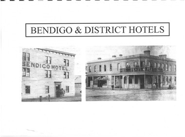
... bendigo Advertiser 1888-1935. Two copies One by year. One alphabetical. District statistics - Mayors and Shire Presidents, Bendigo Football League Premiers 1880- 1987, Sportstar of the year 1965-1987 Plans of townships and Parishes held at Ducley House. ...bendigo Advertiser 1888-1935. Two copies One by year. One alphabetical. District statistics - Mayors and Shire Presidents, Bendigo Football League Premiers 1880- 1987, Sportstar of the year 1965-1987 Plans of townships and Parishes held at Ducley House. ...Indexes Includes Names from the 1856 Petition Bendigo and District Hotels Final Marunari List Terry Davidson 1871 - 2018 Index to RHSV Bendigo Branch Newsletters Nov. 1971 - July 2002 Helen Mainka 1954 Bendigo Business District Directory McConnell’s Street and general Directory Date unknown Victorian Directory 1904 Bendigo and District Directory 1904 – 1905 Bendigo district general Directory 1859 City of Bendigo Historical Information Bendigo Hotels compiled by Len Bennetts Hotels of Bendigo and District Compiled by Len Bennetts Sandhurst Land Sales 1854 – 1856 Ralph Birrell Chronicles of Bendigo from the Bendigo Advertiser Christmas Supplement December 22 1904 Some Photographers 1850 – 1900. Including some Bendigo Photographers 1854 – 1958 St. Patrick’s Annual Sports advertisers. Date Unknown Fatalities listed in bendigo Advertiser 1888-1935. Two copies One by year. One alphabetical. District statistics - Mayors and Shire Presidents, Bendigo Football League Premiers 1880- 1987, Sportstar of the year 1965-1987 Plans of townships and Parishes held at Ducley House. From the Bendigo Lands Office 1976. -
 Bendigo Military Museum
Memorabilia - MEDALLION, SHIRE OF EAST LODDON WW1, Shire of East Loddon, c.1919-20
... Bendigo goldfields Part of the "Robert H. Baron", No. 3596 and Cooper Collections. See catalogue No. 1981P for details of R.H. Baron's service. Robert H. Baron Cooper Collection Badge Shire ...Part of the "Robert H. Baron", No. 3596 and Cooper Collections. See catalogue No. 1981P for details of R.H. Baron's service.Gold coloured metal medallion. Obverse side features an Australian Coat of Arms in the middle. Above the Coat of Arms are two clasped hands. Encircling the Coat of Arms are two rifles and a floral chain. A small ring is attached at the top to hold a chain. Recipients' details are engraved on the back. Hallmark stamped on bottom of back.Engraved on reverse side: "Presented by the Shire of East Loddon to R.H. Baron in grateful appreciation of service rendered in A.I.F. in the Great War." Stamped on reverse side at bottom "Hallmark Symbols".robert h. baron, cooper collection, badge, shire badge.