Showing 478 items matching " transport routes"
-
 Melbourne Tram Museum
Document - List, Melbourne & Metropolitan Tramways Board (MMTB), "Transport Routes Bus and Cab 1938", 29/11/1938 12:00:00 AM
... "Transport Routes Bus and Cab 1938"...See also Reg Item 2602 for a similar 1930 listing. "Transport Routes Bus and Cab 1938" Document List Melbourne & Metropolitan Tramways Board (MMTB) G. ...List within a manila document file containing: 1 - Letter, carbon copy, to Hon G. L Goudie - Minister of Public Works, forwarding a list of the Motor Bus and Motor Cab Routes in the Metropolitan Area, dated 29/11/1938 - set of three blue quarto sheets pinned together. 2 - Letter from the Secretary of the Department of Works C.C. Gale acknowledging receipt typed on quarto paper. 3 - Bound set of the list - carbon copy listing each route, description, and its impact on the tramway or railways and whether it duplicates other routes or is redundant. Approx 100 foolscap sheets stapled with brown cardboard binding strips on the left hand side. See also Reg Item 2602 for a similar 1930 listing.trams, tramways, regulations, mmtb, tramways, buses -
 Whitehorse Historical Society Inc.
Pamphlet, Getting about Nunawading, 1990's
... Maps of schools, parks, bicycle and public transport routes in the City of Nunawading....Whitehorse Historical Society Inc. 2-10 Deep Creek Road Mitcham melbourne Public Transport City of Nunawading Maps of schools, parks, bicycle and public transport routes in the City of Nunawading. Maps of schools, parks, bicycle and public transport routes in the City of Nunawading. ...Maps of schools, parks, bicycle and public transport routes in the City of Nunawading.Maps of schools, parks, bicycle and public transport routes in the City of Nunawading.Maps of schools, parks, bicycle and public transport routes in the City of Nunawading.public transport, city of nunawading -
 Glen Eira Historical Society
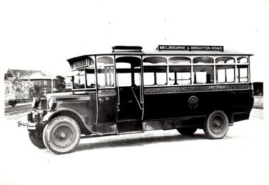
Photograph - Melbourne and Metropolitan Tramways, Buses
... ... Transport routes...route. Depicted on the side of two buses is an emblem, possibly of the Melbourne and Metropolitan Tramways Board. Buses Motor vehicles Public transport Caulfield Elsternwick Vehicles Insignia Transport routes Thoroughfares Information an exchange objects Melbourne Metropolitan Tramways Board Bus routes Photograph Melbourne and Metropolitan Tramways, Buses ...This file contains one item. 1. Three black and white photographs of four Melbourne and Metropolitan Tramways Board buses, dates and photographer unknown. Photographs are of buses on the Melbourne – Brighton Road route, Melbourne – Elsternwick via High Street route, and Caulfield – Ripponlea – Spencer Street route. Depicted on the side of two buses is an emblem, possibly of the Melbourne and Metropolitan Tramways Board.buses, motor vehicles, public transport, caulfield, elsternwick, vehicles, insignia, transport routes, thoroughfares, information an exchange objects, melbourne metropolitan tramways board, bus routes -
 Ballarat Tramway Museum
Map, Ministry of Transport, "Metropolitan Transport Services Map - Melbourne - Tram and Bus Services", c1970
... ... Public Transport... Routes...Pocket size - folded - public transport map of Melbourne, printed in colours showing the bus, train and tram routes around Melbourne. ...Ballarat Tramway Museum South Gardens Reserve Wendouree Parade Ballarat Ballarat goldfields Trams tramways Melbourne Map Public Transport Routes Pocket size - folded - public transport map of Melbourne, printed in colours showing the bus, train and tram routes around Melbourne. ...Pocket size - folded - public transport map of Melbourne, printed in colours showing the bus, train and tram routes around Melbourne. Has a cover price of 10c. No printing date shown, but c1970 as distances are still in imperial, the West gate bridge is shown, though so is the Williamstown Ferry. Gives telephone numbers in 6 digit figures. Lists route numbers for trams, tramways board bus services and private services. Gives various telephone numbers for further information. Notes the map is a combined effort of the Tramways Board, Victorian Railways, Bus Proprietors' Association and the Transport Regulation Board. Single sheet of paper folded in 9 x 3 folds.trams, tramways, melbourne, map, public transport, routes -
 Kew Historical Society Inc
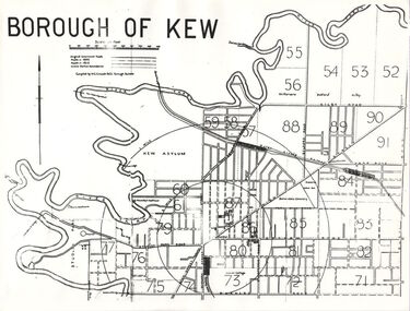
Plan, Borough of Kew, 1910
... Sections of the plan are marked with the location of particular buildings, farms or transport routes....Sections of the plan are marked with the location of particular buildings, farms or transport routes. Borough of Kew Plan Plan Borough of Kew ...This work forms part of the collection assembled by the historian Dorothy Rogers, that was donated to the Kew Historical Society by her son John Rogers in 2015. The manuscripts, photographs, maps, and documents were sourced by her from both family and local collections or produced as references for her print publications. Many were directly used by Rogers in writing ‘Lovely Old Homes of Kew’ (1961) and 'A History of Kew' (1973), or the numerous articles on local history that she produced for suburban newspapers. Most of the photographs in the collection include detailed annotations in her hand. The overhead transparency is of a map produced by H.C. Crouch Borough Surveyor in 1910The Rogers Collection provides a comprehensive insight into the working habits of a historian in the 1960s and 1970s. Together it forms the largest privately-donated collection within the archives of the Kew Historical Society.An overhead transparency of a plan of Kew comparing the roads in 1860 with later roads constructed by 1910. Sections of the plan are marked with the location of particular buildings, farms or transport routes.Borough of Kewborough of kew, h.c. crouch -
 Bendigo Military Museum
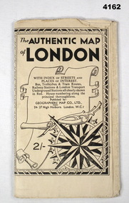
Map - MAP of LONDON, The Authentic Map of London
... Black and white folded street map with transport routes/stations marked in orange. Cover is black and white print, features a scroll and compass design inside a B & W border, written details in black type, street index printed on inside of the cover....Refer cCat No 3536P for his service details. map london Black and white folded street map with transport routes/stations marked in orange. Cover is black and white print, features a scroll and compass design inside a B & W border, written details in black type, street index printed on inside of the cover. ...Map of London with also places of interest. Part of th collection of Frederick Gardner Davey DFC No 410533 RAAF. Refer cCat No 3536P for his service details.Black and white folded street map with transport routes/stations marked in orange. Cover is black and white print, features a scroll and compass design inside a B & W border, written details in black type, street index printed on inside of the cover.map, london -
 Melbourne Tram Museum
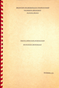
Document - Report, Melbourne & Metropolitan Tramways Board (MMTB), "Traffic Operations Investigations - Route Study Methodology", Nov. 1975
... Looks at the methodology for studying the operating characteristics of transport route and the programme for doing it. ...Looks at the methodology for studying the operating characteristics of transport route and the programme for doing it. ...Report - Foolscap, card covers, red comb binding, 15 pages, titled "Traffic Operations Investigations - Route Study Methodology". Looks at the methodology for studying the operating characteristics of transport route and the programme for doing it. Dated Nov. 1975. Signed R B Sinclairtrams, tramways, routes, passengers, planning, development -
 Melbourne Tram Museum
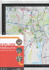
Book, Metlink, "Explore Melbourne on train, tram and bus", Jan. 2009
... Book - 42 pages + cover + foldout map, perfect bound - titled "Explore Melbourne on train, tram and bus" giving details of many locations, venues that could be travelled to by public transport, how to buy Metcards, map of the inner area and transport routes. Places of Interest...Melbourne Tram Museum 8 Wallen Road Hawthorn melbourne Trams tramways Melbourne Local History Metlink Public Transport Map Book - 42 pages + cover + foldout map, perfect bound - titled "Explore Melbourne on train, tram and bus" giving details of many locations, venues that could be travelled to by public transport, how to buy Metcards, map of the inner area and transport routes. Places of Interest "Explore Melbourne on train, tram and bus" Book Metlink ...Book - 42 pages + cover + foldout map, perfect bound - titled "Explore Melbourne on train, tram and bus" giving details of many locations, venues that could be travelled to by public transport, how to buy Metcards, map of the inner area and transport routes. Places of Interesttrams, tramways, melbourne, local history, metlink, public transport, map -
 Melbourne Tram Museum
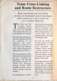
Document - PTC, Public Transport Corporation (PTC), "Tram cross-linking and route restructure", c1991
... transport...tramways...tram routes...Yields information about proposals to link Cross city Melbourne tram routes. Melbourne public transport tramways tram routes linking routes cross linking Five A4 page document, stapled in top left hand corner. ...Provides proposals to link cross Melbourne tram routes together, eg Glen Huntly road routes with West Brunswick. The proposal did not proceed. Gives details of the proposals, those routes not to be linked, maps, looks at each of the linked routes. Predicated $100 million in savings. Part of the Tram and Bus Strategic Review Committee work. c1991.Yields information about proposals to link Cross city Melbourne tram routes.Five A4 page document, stapled in top left hand corner.melbourne, public transport, tramways, tram routes, linking routes, cross linking -
 Melbourne Tram Museum
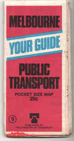
Ephemera - Map, Ministry of Transport, "Melbourne Your Guide PUblic Transport Pocket size map", 1979
... Provided a detailed map of Melbourne's public transport, route number list and brief description. ...Melbourne Tram Museum 8 Wallen Road Hawthorn melbourne Provided a detailed map of Melbourne's public transport, route number list and brief description. ...Provided a detailed map of Melbourne's public transport, route number list and brief description. Has contact details for bookings and lost property etc. Priced 20c, published 1979 as map No. 9Demonstrates the methodology of providing map and transport information at the time.Fold out map (27 sections 9 across x 3 deep), coloured of Melbourne's Tram and Bus routes, route numbers, rail lines, detailed for the central part of Melbourne and insert section for Frankston. melbourne, map, tram and bus services, railways, mmtb, ministry of transport -
 Melbourne Tram Museum
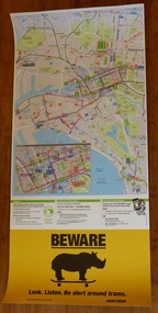
Poster, Yarra Trams, CBD and inner city tram routes, January 2012
... Full colour poster printed on a vinyl plasticized based sheet showing all the public transport routes to the north and south of the CBD, includes major landmarks. ...Melbourne Tram Museum 8 Wallen Road Hawthorn melbourne Trams tramways Yarra Trams Maps PTV Melbourne Public Transport Rhinos Full colour poster printed on a vinyl plasticized based sheet showing all the public transport routes to the north and south of the CBD, includes major landmarks. ...Full colour poster printed on a vinyl plasticized based sheet showing all the public transport routes to the north and south of the CBD, includes major landmarks. Has information on where to buy tickets, customer information and tram tracker. At the base has a Beware Rhino's image. Has the Melway image as well. Dated Effective - January 2012.trams, tramways, yarra trams, maps, ptv, melbourne, public transport, rhinos -
Melbourne Tram Museum
Document - Rconstruction of tram tracks - Bourke and Spencer Sts, Yarra Trams, 2/2026
... Gives details of dates, alternative transport routes, and an accessible bus operated by Travellers' Aid....Gives details of dates, alternative transport routes, and an accessible bus operated by Travellers' Aid. ...Digital document from the Yarra Trams and Transport Victoria website about the reconstruction of the tram tracks at the intersection of Spencer and Bourke Sts, Feb. 2026. Gives details of dates, alternative transport routes, and an accessible bus operated by Travellers' Aid.Yields information about the 2026 reconstruction of Spencer and Bourke St intersection.Digital document from Yarra trams.tram stops, tramways, bourke st, spencer st, accessibility, track works -
 Melbourne Tram Museum
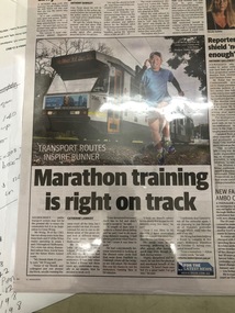
Newspaper, Herald Sun, "Marathon training is right on track", 1/10/2019 12:00:00 AM
... "Marathon training is right on track" by Catherine Lambert "Transport routes inspire runner" Cyrus Wong has run along every train line, tram track and most bus routes in zones 1 and 2. ...Melbourne Tram Museum 8 Wallen Road Hawthorn melbourne Trams tramways Tram Routes B class tram 2061 "Marathon training is right on track" by Catherine Lambert "Transport routes inspire runner" Cyrus Wong has run along every train line, tram track and most bus routes in zones 1 and 2. ..."Marathon training is right on track" by Catherine Lambert "Transport routes inspire runner" Cyrus Wong has run along every train line, tram track and most bus routes in zones 1 and 2. Article shows Mr Wong running with tram number 2061 in background. Tram displays route 58, via William St & Zootrams, tramways, tram routes, b class, tram 2061 -
 Orbost & District Historical Society
Photograph - Sailing on the Snowy River c. 1890-1910, c.1890-1910
... The river has always been used for outings as well as a major transport route from the 1870s onwards. This photo shows a quiet outing on the river. ...The river has always been used for outings as well as a major transport route from the 1870s onwards. This photo shows a quiet outing on the river. ...This is a photograph from c1890-1910 of a recreational outing in a small yacht, probably on the Snowy River near Orbost/Marlo. The river has always been used for outings as well as a major transport route from the 1870s onwards. This photo shows a quiet outing on the river. This photo is significant because it shows a recreational use of the Snowy River near Orbost/Marlo.A b/w photograph of a small yacht with 2 sails. It has 6 people on it, with the boat in the middle of a river and riverside vegetation behind.On back of photo: 'Could be Percy Watt's boat'.snowy river, sailing -
 Kew Historical Society Inc
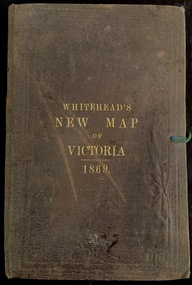
Map, Whitehead's Map of Victoria, With Alphabetical Key, 1869, 1869
... Map of Victoria with gold mining areas, notes on topography, transport routes. Relief shown by hachures. List of towns with distance from Melbourne in map margin. ...In addition to its historical significance, this is a rare map, of which the only known copies in Australian public collections are those held at the National Library of Australia, the State Library of Victoria, State Library of New South Wales and the University of Queensland Library. maps - victoria - 1860s e whitehead's new map of victoria 1869 whitehead's map of victoria with alphabetical key 1869 cartography gold rush Cover "WHITEHEAD'S NEW MAP OF VICTORIA 1869" Map of Victoria with gold mining areas, notes on topography, transport routes. Relief shown by hachures. List of towns with distance from Melbourne in map margin. ...When E. Whitehead's New Map of Victoria was released in 1869, an advertisement in the Bendigo Advertiser (16 July 1869) noted that: "This beautifully engraved Map has been revised and brought down to the present time; and, with the Alphabetical Key, is the most complete and the cheapest Map ever published; Price, 6d plain; 1s colored; 2s 6d in case; on linen, post free, 2d extra. E.. WHITEHEAD and CO, Publishers, 67 Collins-street east." The following year, 1870, Whitehead's promoted the edition in the Portland Guardian and Normanby General Advertiser (3 January 1870), advising that: "WHITEHEAD'S NEW MAP OF VICTORIA, 1869 ... is corrected to the latest date, and around is arranged an Alphabetical Key, with Post Towns and Money Order Olffices marked. The Map being divided into squares and numbered, by reference to the Key any place can be found immediately. Price Is beautifully colored, or mounted on linen in case, 2s 6d. Post free, 2d extra, in Victoria. B. Whitehead and C0., Puolishers, 67 Collins-street East, Melbourne". In the same edition of the Portland Advertiser, they also promoted their business generally, saying: "E WHITEHEAD and Co., Stationers, Engravers, Lithographers, 67 Collins street East, execute every description of Lithographic PRINTING, BILL-HEADS. NOTE Headings. Business Dies Engraved and Embossed on Envelopes &c. ARMS, MONOGRAMS, AND CRESTS Engraved and Embossed in Colour, superior to any other house in the Colony. Specimens, post free, 2d. Lithographers, &c, to H.R.H. the Duke of Edinburgh, and Die-inkers and Embossers to His Excellency Sir J. H. T. Manners-Sutton, K C.B. Orders executed for the Trade". Whitehead’s New Map of Victoria 1869 is is an important record of region created towards the end of the Victorian Gold Rush (1851-1869). In addition to its historical significance, this is a rare map, of which the only known copies in Australian public collections are those held at the National Library of Australia, the State Library of Victoria, State Library of New South Wales and the University of Queensland Library.Map of Victoria with gold mining areas, notes on topography, transport routes. Relief shown by hachures. List of towns with distance from Melbourne in map margin. [Melbourne] : Printed & Published by ... E Whitehead & Co ... 67 Collins Street East, 1869 1 map : col., mounted on linen ; 38.4 x 55.4 cm, folded to 18 x 12 cm.Cover "WHITEHEAD'S NEW MAP OF VICTORIA 1869"maps - victoria - 1860s, e whitehead's new map of victoria 1869, whitehead's map of victoria with alphabetical key 1869, cartography, gold rush -
 Melbourne Tram Museum
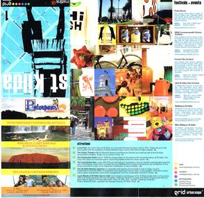
Pamphlet, Grid Urban Maps, "St Kilda grid urban maps", mid 2000's
... Pamphlet - 12 fold sheet, full colour, titled "St Kilda grid urban maps" showing a map of St Kilda area, public transport routes, locations, description of attractions, festivals, events, and retail and food outlets with a small entry for each advertiser. ...Melbourne Tram Museum 8 Wallen Road Hawthorn melbourne Trams tramways St Kilda Maps Events Public Transport Pamphlet - 12 fold sheet, full colour, titled "St Kilda grid urban maps" showing a map of St Kilda area, public transport routes, locations, description of attractions, festivals, events, and retail and food outlets with a small entry for each advertiser. ...Pamphlet - 12 fold sheet, full colour, titled "St Kilda grid urban maps" showing a map of St Kilda area, public transport routes, locations, description of attractions, festivals, events, and retail and food outlets with a small entry for each advertiser. Has Metlink logo. Published by Grid Urban Maps - www.gridmaps.com.au - not functioning at 15/1/2019.trams, tramways, st kilda, maps, events, public transport -
 Melbourne Tram Museum
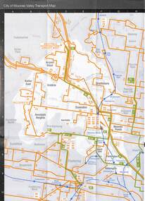
Map - Set of 3, Metlink, "Your Guide to Melbourne's Public Transport System - City of Manningham", c2005
... Has a map of transport routes in the City of Manningham, details of Metcards, bus routes, maps of the tram and train network and Metcard agents. 2 - as for .1, but for the City of Moonee Valley 3 - ditto for City of Boroondara...Has a map of transport routes in the City of Manningham, details of Metcards, bus routes, maps of the tram and train network and Metcard agents. 2 - as for .1, but for the City of Moonee Valley 3 - ditto for City of Boroondara Demonstrates a map produced by Metlink for each municipality. ...Folded map titled "Your Guide to Melbourne's Public Transport System - City of Manningham", published by Metlink c2005. Has a map of transport routes in the City of Manningham, details of Metcards, bus routes, maps of the tram and train network and Metcard agents. 2 - as for .1, but for the City of Moonee Valley 3 - ditto for City of BoroondaraDemonstrates a map produced by Metlink for each municipality.Map - 18 fold - 6x3 - pocket size, printed in full colour.trams, tramways, maps, city of manningham, city of moonee valley, city of boroondara, metlink -
 Melbourne Tram Museum
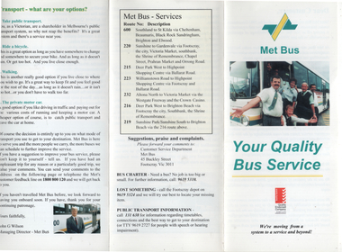
Pamphlet, Met Bus, "Met Bus - Your Quality Bus Service", c1993
... Pamphlet produced by Met Bus, the Government operator of 7 routes following the 1993 tender to provide information on the operation, its plans, public transport, routes operated, contact details and general information. ...Melbourne Tram Museum 8 Wallen Road Hawthorn melbourne Pamphlet produced by Met Bus, the Government operator of 7 routes following the 1993 tender to provide information on the operation, its plans, public transport, routes operated, contact details and general information. ...Pamphlet produced by Met Bus, the Government operator of 7 routes following the 1993 tender to provide information on the operation, its plans, public transport, routes operated, contact details and general information. Managing Director John G Wilson. Services were operated out of the former Footscray Tram depot in Buckley St.Yields information about Met Bus in 1993.Pamphlet, 3 fold DLfull colour.met bus, buses, public transport -
 Melbourne Tram Museum
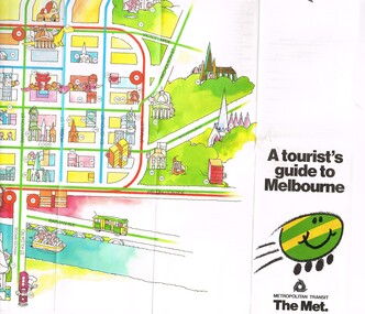
Pamphlet, The Met, "A tourist's guide to Melbourne", mid 1980's
... Gives a cartoon style map of the CBD, Melbourne suburbs and outer Melbourne, giving a list of places of interest and transport routes. Shows the vintage tram service along Batman Ave, Puffing Billy, Wattle Park, various precincts, shopping centres. ...Gives a cartoon style map of the CBD, Melbourne suburbs and outer Melbourne, giving a list of places of interest and transport routes. Shows the vintage tram service along Batman Ave, Puffing Billy, Wattle Park, various precincts, shopping centres. ...Pamphlet, 14 fold printed in full colour on semi gloss paper, both sides. Gives a cartoon style map of the CBD, Melbourne suburbs and outer Melbourne, giving a list of places of interest and transport routes. Shows the vintage tram service along Batman Ave, Puffing Billy, Wattle Park, various precincts, shopping centres. Published by The Met, Metropolitan Transit and has the buzz logo on the front. Mid 1980's. Two copies heldtrams, tramways, maps, tourism, melbourne, wattle park, the met -
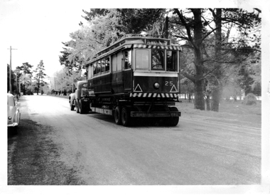 Ballarat Tramway Museum
Photograph - Digital image, Wal Jack, 6/10/1960 12:00:00 AM
... On rear of photograph in ink "SEC, Ballarat Loading No. 25 on Yellow Express road transport en route to Bendigo near Wendouree depot 6-10-1960." and in top Right hand corner Wal Jack stamp with "T258" written in....Trams tramways Transporting Trams Yellow Express Bendigo Wendouree Parade Moving Trams tram 25 On rear of photograph in ink "SEC, Ballarat Loading No. 25 on Yellow Express road transport en route to Bendigo near Wendouree depot 6-10-1960." and in top Right hand corner Wal Jack stamp with "T258" written in. ...Yields information about the loading and departure of Ballarat No. 25 to Bendigo in 1960.Digital image from the Wal Jack Ballarat Album of a photograph of No.25 in Wendouree Parade, departing for Bendigo 6-10-1960, Photo Wal Jack. See image i2 for rear of photograph.On rear of photograph in ink "SEC, Ballarat Loading No. 25 on Yellow Express road transport en route to Bendigo near Wendouree depot 6-10-1960." and in top Right hand corner Wal Jack stamp with "T258" written in.trams, tramways, transporting trams, yellow express, bendigo, wendouree parade, moving trams, tram 25 -
 Eltham District Historical Society Inc
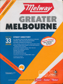
Book, Melway Publishing, Melway Greater Melbourne street directory : including Geelong, Phillip Island, Healesville, Kinglake, Gisborne, Lorne, Wallan, Bacchus Marsh Bellarine & Mornington Peninsulas; Edition 33, 2006, 2005
... Detailed public transport routes - train, tram, bus, bicycle paths & shared road routes. ...Detailed public transport routes - train, tram, bus, bicycle paths & shared road routes. ...Edition 33. 2006 Coloured detailed maps accessed by a street or location index. Cover: Totally revised and updated with over 1380 new street listings new maps covering Mount Duneed on the Bellarine Peninsula, Pakenham South and Rythdale. Detailed public transport routes - train, tram, bus, bicycle paths & shared road routes. Eastlink fully detailed new Craigieburn bypass GPS compatible WGS/MGA Grid Special feature: New Hierachy of Roads Street directory with plastic cover, coloured maps, 902 pagesstreets,roads,melbourne,map,melway -
 Eltham District Historical Society Inc
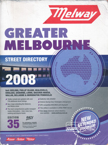
Book, Melway Greater Melbourne street directory 2008 : including Geelong, Phillip Island, Healesville, Kinglake, Gisborne, Lorne, Bacchus March, Wallan, Bellarine & Mornington Peninsulas; Edition 35, 2008, 2007
... The most comprehensive public transport routes information - train, tram, bus, walking and bicycle tracks. ...The most comprehensive public transport routes information - train, tram, bus, walking and bicycle tracks. ...Edition 35. 2008 Coloured detailed maps accessed by a street or location index. Cover: Totally revised and updated with over 730 additional street listings, new maps extending the Gisbourne and Wallan areas. The most comprehensive public transport routes information - train, tram, bus, walking and bicycle tracks. Eastlink fully detailed, Victoria Racing Club, Flemington enlargement, GPS compatible WGS/MGA Grid displayed, This editon is available in LARGE PRINT format, new eway electronic street directory now available - www.melway.com.au Special feature: New Hierachy of Roads Street directory, coloured maps, indexes, 1201 pagesstreets,roads,melbourne,map,melway -
 Kew Historical Society Inc
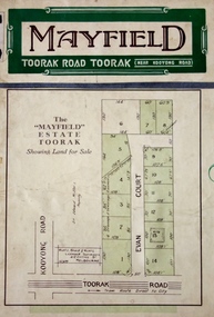
Plan - Subdivision Plan, Mayfield Estate, 1927
... This emphasis on existing transport routes was a feature of subdivisions during a period when car ownership was the preserve of the wealthy. ...This emphasis on existing transport routes was a feature of subdivisions during a period when car ownership was the preserve of the wealthy. ...A number of the plans in the Kew Historical Society’s collection can also be found in other collections, such as those of the State Library of Victoria. A number are however unique to the collection.The Kew Historical Society collection includes almost 100 subdivision plans pertaining to suburbs of the City of Melbourne. Most of these are of Kew, Kew East or Studley Park, although a smaller number are plans of Camberwell, Deepdene, Balwyn and Hawthorn. It is believed that the majority of the plans were gifted to the Society by persons connected with the real estate firm - J. R. Mathers and McMillan, 136 Cotham Road, Kew. The Plans in the collection are rarely in pristine form, being working plans on which the agent would write notes and record lots sold and the prices of these. The subdivision plans are historically significant examples of the growth of urban Melbourne from the beginning of the 20th Century up until the 1980s. A number of the plans are double-sided and often include a photograph on the reverse. A number of the latter are by noted photographers such as J.E. Barnes.The Mayfield Estate subdivision included 14 allotments surrounding Evan Court (now Evans Court) in Toorak. The subdivision adjoined Toorak Road east of Kooyong Road and alerted prospective buyers to how the Toorak Road tram would take them directly to the city. This emphasis on existing transport routes was a feature of subdivisions during a period when car ownership was the preserve of the wealthy. An existing brick villa (‘Mayfield’) is noted as already constructed on lot 13. The subdivision also notes that the lots adjoin land owned by Sir Edward Miller. Today Evans Court extends beyond this subdivision through to Moonga Road.subdivision plans - toorak, mayfield estate, sir edward miller -
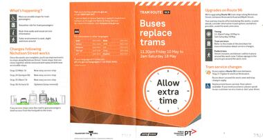 Melbourne Tram Museum
Pamphlet, Public Transport Victoria (PTV), "Bus replace trams - tram route 96", Apr. 2019
... Has alternative transport routes and stop changes. Shows the map of work and alternative services. 2 - 6 fold DL titled Bus replace trams - tram route 75" for period 3/1 to 12/1/2018 for works in Toorak Road Burwood. ...Has alternative transport routes and stop changes. Shows the map of work and alternative services. 2 - 6 fold DL titled Bus replace trams - tram route 75" for period 3/1 to 12/1/2018 for works in Toorak Road Burwood. ...Set of two Pamphlets 1 - 4 fold DL full colour, titled "Bus replace trams - tram route 96" for the period 10 May to 18 May 2019, to undertake track work and installation of super stops in Nicholson St north of Holden St. Has alternative transport routes and stop changes. Shows the map of work and alternative services. 2 - 6 fold DL titled Bus replace trams - tram route 75" for period 3/1 to 12/1/2018 for works in Toorak Road Burwood. Similar to above. Has the Transport for Victoria, Yarra Trams and PTV logos. Published 2019. See Reg Item 3630 for other associated documents for this project.trams, tramways, nicholson st, route 96, trackwork, superstops, yarra trams, route 75, toorak road, burwood -
 Surrey Hills Historical Society Collection
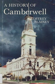
Book, A history of Camberwell, 1980
... He has traced the coming of the wood-cutters and the farmers, the transition from rectangular paddocks to a grid of roads and streets, the growth from shire to borough, town and city, the filling up of thirteen squares miles into residential suburbia - in successive waves of invasion, along new transport routes - including the Outer Circle Railway. ...He has traced the coming of the wood-cutters and the farmers, the transition from rectangular paddocks to a grid of roads and streets, the growth from shire to borough, town and city, the filling up of thirteen squares miles into residential suburbia - in successive waves of invasion, along new transport routes - including the Outer Circle Railway. ...In 1964 Camberwell City Council commissioned Professor Geoffrey Blainey to first write this history. Since that time, many changes have taken place and therefore the Council asked Professor Blainey to bring the book up to date. Bibliography, includes index. The author presents a century of pioneering development and endeavours. He has traced the coming of the wood-cutters and the farmers, the transition from rectangular paddocks to a grid of roads and streets, the growth from shire to borough, town and city, the filling up of thirteen squares miles into residential suburbia - in successive waves of invasion, along new transport routes - including the Outer Circle Railway. Substantial chapters cover the War Years and the progress of Camberwell since the 1960s have also been included in this edition. 134p; ill;camberwell, victoria, market gardens, tolls, railways, mayors, boroondara road board, borondara shire, councillors, (mr) (prof) geoffrey blainey -
 Halls Gap & Grampians Historical Society
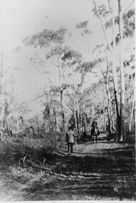
Photograph - B/W, C 1880s
... It shows methods of transport and the access route to Halls Gap in the late 19th Century....It shows methods of transport and the access route to Halls Gap in the late 19th Century. ...This photo is of the road approaching Delley's Bridge. It shows methods of transport and the access route to Halls Gap in the late 19th Century.A man with a walking stick walking away from the camera on a rutted dirt road through trees and bush. Another man is approaching from the opposite direction on horseback.access routes, roads -
 Melbourne Tram Museum
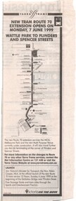
Newspaper, The Age, "New Tram route 70 Extension opens on Monday 7 June 1999 - Wattle Park to Flinders and Spencer St", 5/06/2020 12:00:00 AM
... route 70 Extension opens on Monday 7 June 1999 - Wattle Park to Flinders and Spencer St". Has a map of the new service and an invite for people to attend the formal opening on 6/6/1999 by Robin Cooper, Minister for Transport. ...route 70 Extension opens on Monday 7 June 1999 - Wattle Park to Flinders and Spencer St". Has a map of the new service and an invite for people to attend the formal opening on 6/6/1999 by Robin Cooper, Minister for Transport. ...Newspaper clipping from The Age, 5/6/1999? titled "New Tram route 70 Extension opens on Monday 7 June 1999 - Wattle Park to Flinders and Spencer St". Has a map of the new service and an invite for people to attend the formal opening on 6/6/1999 by Robin Cooper, Minister for Transport. This route deviation saw the closure of the Batman Ave terminus.trams, tramways, route 70, batman ave, closure, opening, spencer st -
 Melbourne Tram Museum
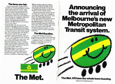
Pamphlet, The Met, "Announcing the arrival of Melbourne's new Metropolitan Transit system", late 1983
... Pamphlet focused on the Ringwood Zone, has a detailed map of the public transport routes within the zone. 2nd copy added 14-5-2016 from the estate of Charles Craig. .2 - Inner .3 - St Albans .4 - Dandenong .5 - Box Hill - (two copies held) .6 - Frankston .7 - Moorabbin .8 - Greensborough .9 - Werribee - added 26/10/2016....Pamphlet focused on the Ringwood Zone, has a detailed map of the public transport routes within the zone. 2nd copy added 14-5-2016 from the estate of Charles Craig. .2 - Inner .3 - St Albans .4 - Dandenong .5 - Box Hill - (two copies held) .6 - Frankston .7 - Moorabbin .8 - Greensborough .9 - Werribee - added 26/10/2016. ...Set of 9 pamphlets about the Neighbourhood ticket system - basically the same with changes for each neighbourhood. .1 - Eight page, A4, colour printed on gloss paper, centre stapled, titled "Announcing the arrival of Melbourne's new Metropolitan Transit system - Ringwood Neighbourhood" Explains the revised ticketing system, known as Neighbourhoods, notes the formation of The Met, uses a cartoon characterisation of vehicles, explains how the system works, boundaries, various options, travel cards, concessions and introductory offers. Pamphlet focused on the Ringwood Zone, has a detailed map of the public transport routes within the zone. 2nd copy added 14-5-2016 from the estate of Charles Craig. .2 - Inner .3 - St Albans .4 - Dandenong .5 - Box Hill - (two copies held) .6 - Frankston .7 - Moorabbin .8 - Greensborough .9 - Werribee - added 26/10/2016.trams, tramways, map, the met, tickets, fares, ringwood -
 Melbourne Tram Museum
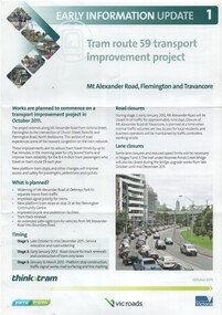
Pamphlet, VicRoads, "Tram route 59 transport improvement project", Oct. 2011
... "Tram route 59 transport improvement project"...Pamphlet - 3 fold DL - titled "Tram route 59 transport improvement project", Early information update 1, detailing with a plan changes to Mount Alexander Road, Flemington and Travencore, Oct. 2011. ...Has the Yarra Trams, VicRoads, Think Tram and Victorian Government logos. "Tram route 59 transport improvement project" Pamphlet VicRoads ...Pamphlet - 3 fold DL - titled "Tram route 59 transport improvement project", Early information update 1, detailing with a plan changes to Mount Alexander Road, Flemington and Travencore, Oct. 2011. Gives details of the staging, roadworks and timing. Has the Yarra Trams, VicRoads, Think Tram and Victorian Government logos.trams, tramways, mount alexander road, route 59, trackwork, road works -
 Melbourne Tram Museum
Pamphlet, P. Thomas, South Melbourne Depot, "Cross City Linking - A plan for the future or another PTC Fiasco????", c1992
... , looking at the proposed project , relationships with the Public Transport Users Association (PTUA), route changes, union actions, impacts of proposals and asking members to be involved in the proposal at South Melbourne Depot - c1992 See Reg Item 1535 for a report on this project....Melbourne Tram Museum 8 Wallen Road Hawthorn melbourne Trams tramways The Met Unions South Melbourne Depot Management PTC Routes W Class Operations Buses PTUA Pamphlet, letter or notice - photocopy onto an A4 sheet, both sides, titled "Cross City Linking - A plan for the future or another PTC Fiasco????", looking at the proposed project , relationships with the Public Transport ...Pamphlet, letter or notice - photocopy onto an A4 sheet, both sides, titled "Cross City Linking - A plan for the future or another PTC Fiasco????", looking at the proposed project , relationships with the Public Transport Users Association (PTUA), route changes, union actions, impacts of proposals and asking members to be involved in the proposal at South Melbourne Depot - c1992 See Reg Item 1535 for a report on this project.trams, tramways, the met, unions, south melbourne depot, management, ptc, routes, w class, operations, buses, ptua