Showing 7 items matching " white hills public cemetery"
-
 Bendigo Historical Society Inc.
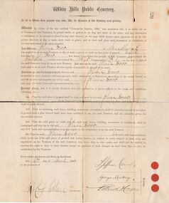
Document - DORR FAMILY DOCUMENTS - PERMIT TO DIG GRAVE OR VAULT
... ... White Hills Public Cemetery...Greyish document from the White Hills Public Cemetery permitting John Dorr to dig a grave or vault and the conditions of same. ...History House 11 Mackenzie Street Bendigo goldfields DOCUMENT Certificate White Hills Cemetery Dorr Family Documents - Permit to Dig Grave or Vault John Dorr White Hills Public Cemetery Jefferson Connelly George Mackay Patrick Hayes Greyish document from the White Hills Public Cemetery permitting John Dorr to dig a grave or vault and the conditions of same. ...Greyish document from the White Hills Public Cemetery permitting John Dorr to dig a grave or vault and the conditions of same. Dated 6/4/1888. Signed by Trustees, Jefferson Connelly, George Mackay, and Patrick Hayes, and? Secretary. Three small red seals next to where the Trustees signed. Also a photocopy. Document is in three pieces.document, certificate, white hills cemetery, dorr family documents - permit to dig grave or vault, john dorr, white hills public cemetery, jefferson connelly, george mackay, patrick hayes -
 Bendigo Historical Society Inc.
Document - BENDIGO CEMETERIES COLLECTION: BROCHURE
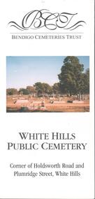
... Colour brochure published by the Bendigo Cemeteries trust titled: White Hills Public Cemetery....History House 11 Mackenzie Street Bendigo goldfields BENDIGO Cemetery white hills cemetery Colour brochure published by the Bendigo Cemeteries trust titled: White Hills Public Cemetery. ...Colour brochure published by the Bendigo Cemeteries trust titled: White Hills Public Cemetery.bendigo, cemetery, white hills cemetery -
 Bendigo Historical Society Inc.
Document - BENDIGO CEMETERIES COLLECTION: BROCHURE
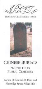
... Colour brochure issued by the Bendigo Cemetery Trust titled: Chinese Burials White Hills Public Cemetery....History House 11 Mackenzie Street Bendigo goldfields BENDIGO Cemetery white hills cemetery Colour brochure issued by the Bendigo Cemetery Trust titled: Chinese Burials White Hills Public Cemetery. ...Colour brochure issued by the Bendigo Cemetery Trust titled: Chinese Burials White Hills Public Cemetery.bendigo, cemetery, white hills cemetery -
 Bendigo Historical Society Inc.
Document - Chinese White Hill Public Cemetery Bendigo Tourist Pamphlet, abt 2000
... Chinese White Hill Public Cemetery Bendigo Tourist Pamphlet...Chinese White Hill Public Cemetery Bendigo Tourist Pamphlet two sided colour Pamphlet; includes location, general photos and information on the Chinese buried in the cemetery....Document Chinese White Hill Public Cemetery Bendigo Tourist Pamphlet ...Chinese White Hill Public Cemetery Bendigo Tourist Pamphlet two sided colour Pamphlet; includes location, general photos and information on the Chinese buried in the cemetery.history, bendigo, chinese, chinese white hills cemetery -
 Federation University Historical Collection
Map, Ballaarat Gold Field, 1861, 21/10/1861
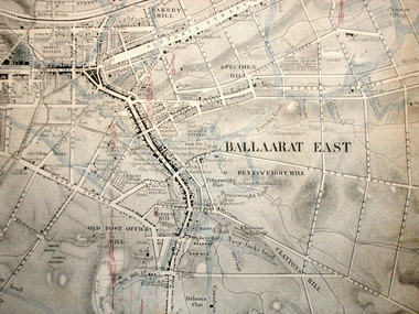
... public garden reserve...manure depot...black hill...ballarat east...old post office hill...pennyweight hill...claytons hill...golden point...mining...railway...cricket ground...swamp creek...cemetery...sludge reserve...bakery hill...gaelic church...juvenile reformatory...orphanage...specimen hill...eureka lead...cattle yard hill...dalton's flat...chinese village...poverty hill...railway reserve...little bendigo diggings...pound reserve...allied armies...flour mill...agricultural reserve...marsh...survey reserve...survey corps...white...In November 2004 the Central Highlands Regional Library presented a special edition of 200 copies of the 1861 map reproduced from a copy in their collection. ballarat map davidson robert brough-smyth fitzpatrick cowan yuille's swamp public garden reserve manure depot black hill ballarat east old post office hill pennyweight hill claytons hill golden point mining railway cricket ground swamp creek cemetery sludge reserve bakery hill gaelic church juvenile reformatory orphanage specimen hill eureka lead cattle yard hill dalton's flat chinese village poverty hill railway reserve little bendigo diggings pound reserve allied armies flour mill agricultural reserve marsh survey reserve survey corps white flat yarrowee yarrowee creek brache j. brache survey ballaarat gold field 1861 Compiled & Drawn from the Survey of Mining Surveyors Davidson, Fitzpatrick and Cowan & the Plans in the Surveyor General's Office by J. ...A party of surveyors camped by Yuille's Swamp (later Lake Wendouree) and surveyed the countryside for a map to be produced by the Geological Survey of Victoria. In November 2004 the Central Highlands Regional Library presented a special edition of 200 copies of the 1861 map reproduced from a copy in their collection. Original geological map of Ballarat showing property, waterways, mines, churches, schools, water races, and garden reserves. It was compiled and drawn from the surveys of Mining Surveyors Davidson, Fitzpatrick and Cowan.Compiled & Drawn from the Survey of Mining Surveyors Davidson, Fitzpatrick and Cowan & the Plans in the Surveyor General's Office by J. Brahe, 21st October 1861. R. Brough Smyth, Secretary for Mines. The Honourable J.B. Humffray, M.L.A. Commr of Mines.ballarat, map, davidson, robert brough-smyth, fitzpatrick, cowan, yuille's swamp, public garden reserve, manure depot, black hill, ballarat east, old post office hill, pennyweight hill, claytons hill, golden point, mining, railway, cricket ground, swamp creek, cemetery, sludge reserve, bakery hill, gaelic church, juvenile reformatory, orphanage, specimen hill, eureka lead, cattle yard hill, dalton's flat, chinese village, poverty hill, railway reserve, little bendigo diggings, pound reserve, allied armies, flour mill, agricultural reserve, marsh, survey reserve, survey corps, white flat, yarrowee, yarrowee creek, brache, j. brache, survey, ballaarat gold field 1861 -
Federation University Historical Collection
Book, Historic Sites Survey: North Central Study Area, 1979, 1979
... public reserves...r.u. nicholls nurseryman...thomas lang...francis moss...ballarat botanical gardens...ballarat school of mines botanical gardens...lake wendouree...victoria park, ballarat...muont holled smith...ballaarat old cemetery planting...eastern oval...ballarat east botanical gardens...ballarat east town hall gardens...eureka stockade reserve...ballarat observatory plantings...yarrowee creek plantings...yarrowee bluestone channels...ballarat woollen mill...band and albion mullock heap...black hill plantings...yarrowee creek channels...canadian creek channel...specimen vale channel...poverty point reserve...union jack reserve buninyong...imperial mine, buninyong...victoria street plantings...bridge mall...sturt street gardens...ballarat avenue of honour plantings...white...Barker Library (top floor) Mount Helen goldfields The North Central Study Area included the Shires of Avoca, Bet Bet, east Loddon, Goulburn, Untly, Kara Kara, Korong, Maldon, Marong, Metcalfe, McIvor, Newstead, Strathfieldsaye, Stawell, Talbot, Clunes, Tullaroop and Waranga. castlemaine mount alexander goldfield maldon percydale warrenmang moliagul tarnagulla stuart mill the whipstick whroo rushworth graytown ironbark forest st arnoaud new bendigo landsborough inglewood kurting wedderburn wehla kooroora langham flat mcintyre rheola diamond hill fosterville coliban water works green gully newstead muckleford forest costerfield graytown bailieston waranga irrigaiton system eucalyptus distillery mia mia bridge korokubeal township researce concegella slate quarry chewton fryerstown kingower timor talbot majorca carisbroook clunes st arnaud taradale icomos dunolly limestone castlemaine slate quarry harcourt granite taradale railway viaduct loddon united waterworks trust gouldburn weir carisbrook lock-up history of tree planting in streets history of public reserves r.u. nicholls nurseryman thomas lang francis moss ballarat botanical gardens ballarat school of mines botanical gardens lake wendouree victoria park, ballarat muont holled smith ballaarat old cemetery planting eastern oval ballarat east botanical gardens ballarat east town hall gardens eureka stockade reserve ballarat observatory plantings yarrowee creek plantings yarrowee bluestone channels ballarat woollen mill band and albion mullock heap black hill plantings yarrowee creek channels canadian creek channel specimen vale channel poverty point reserve union jack reserve buninyong imperial mine, buninyong victoria street plantings bridge mall sturt street gardens ballarat avenue of honour plantings white flat oval plantings camp street elms burnt creek 153 page book with white plastic binding. ...The North Central Study Area included the Shires of Avoca, Bet Bet, east Loddon, Goulburn, Untly, Kara Kara, Korong, Maldon, Marong, Metcalfe, McIvor, Newstead, Strathfieldsaye, Stawell, Talbot, Clunes, Tullaroop and Waranga. 153 page book with white plastic binding. It is an historic sites survey for the North Central Study Area commissioned by the Land Conservation Council, the Ministry for COnservation and the Australian Heritage Commission. castlemaine, mount alexander goldfield, maldon, percydale, warrenmang, moliagul, tarnagulla, stuart mill, the whipstick, whroo, rushworth, graytown ironbark forest, st arnoaud, new bendigo, landsborough, inglewood, kurting, wedderburn, wehla, kooroora, langham flat, mcintyre, rheola, diamond hill, fosterville, coliban water works, green gully, newstead, muckleford forest, costerfield, graytown, bailieston, waranga irrigaiton system, eucalyptus distillery, mia mia bridge, korokubeal township researce, concegella slate quarry, chewton, fryerstown, kingower, timor, talbot, majorca, carisbroook, clunes, st arnaud, taradale, icomos, dunolly, limestone, castlemaine slate quarry, harcourt granite, taradale railway viaduct, loddon united waterworks trust, gouldburn weir, carisbrook lock-up, history of tree planting in streets, history of public reserves, r.u. nicholls nurseryman, thomas lang, francis moss, ballarat botanical gardens, ballarat school of mines botanical gardens, lake wendouree, victoria park, ballarat, muont holled smith, ballaarat old cemetery planting, eastern oval, ballarat east botanical gardens, ballarat east town hall gardens, eureka stockade reserve, ballarat observatory plantings, yarrowee creek plantings, yarrowee bluestone channels, ballarat woollen mill, band and albion mullock heap, black hill plantings, yarrowee creek channels, canadian creek channel, specimen vale channel, poverty point reserve, union jack reserve buninyong, imperial mine, buninyong, victoria street plantings, bridge mall, sturt street gardens, ballarat avenue of honour plantings, white flat oval plantings, camp street, elms, burnt creek -
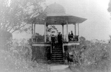 Surrey Hills Historical Society Collection
Photograph, John Gray Memorial Rotunda in Surrey gardens, Union Road, Surrey Hills, c 1925, c 1925
... It is also significant as evidence of the extent of the role of the Surrey Hills Progress Association in the provision of public facilities. rotundas surrey gardens union road surrey hills progress association surrey hills brass band parks and reserves 1925 john gray, clarence montgomery, box hill cemetery, cinema john gray memorial rotunda bandstands A black and white photo of an octagonal rotunda situated within Surrey Gardens taken from the perspective of the main entrance. ...The rotunda was built in 1912 by Clarence Montgomery for the Surrey Hills Progress Association and the local community and dedicated to John Gray, "a highly respected and revered citizen". Surrey Hills Brass Band regularly gave concerts in the rotunda, provided music for regular 'loyal' celebrations and also for silent films held in the gardens. The rotunda was quite elevated off the ground due to the slope of the gardens and the bioscope was stored in the room underneath. This was later used as the infant welfare centre until the Progress Association built a dedicated facility for these purposes. The rotunda was demolished in 1972. Clarence Montgomery, carpenter, was living in Sunbury Crescent in 1914. By 1916 he had moved to 83 Croydon Road where he lived for the rest of his life. Clarence was born in 1869 in Taradale, son of John Montgomery and Jane Ford. He married Sarah Ann Ingram in Echuca in 1894. Their children were: 1. Annie (Mrs P Paynter) born Echuca in 1895 2. William Henry born Echuca in 1897 3. Christina Mary (Mrs F Meyers) born Echuca in 1898 4. Violet (Mrs G Ewing) born Echuca in 1902 5. Clarence George Ingram born Echuca in 1906 and died aged 7 months. Violet became a tailoress and Christina a dressmaker. William became a carpenter like his father. Sarah Ann Montgomery died at their home in June 1932 aged 62 years. Clarence died in August 1946 aged 77 years. They are buried in Box Hill Cemetery (P-EB-0020). John Gray was "actively associated with all movements for the benefit of neighbours and fellow citizens". [Quote from the official tribute on his death in 1909.] He was very active in the Surrey Hills Progress Association in the early 1900's. The rotunda built in the Surrey Gardens by the Progress Association in 1912 was dedicated to him. John Gray was born in 1861 in Eldorado. He died on 7 December 1909 in Surrey Hills and is buried in Box Hill Cemetery (M0472). He married Emma Beckett in 1888 at 'Guildford Villa' in Essex Road, the Beckett home. They are listed in both the 1903 and 1906 electoral rolls in Arundel Crescent; his occupation is given as bootmaker. The Alan Holt property register identifies this as 24 Arundel Crescent, known as 'Tumberumba'. John and Emma had a large family: (Gunner) John Robert Gray (1888, Surrey Hills - 21 June 1917, France) Benjamin Walter Gray (1890, Surrey Hills - 1949, Heidelberg) Herbert Harry Gray (1892, Surrey Hills - 1959, Queensland) William Beckett Gray (1897, Surrey Hills - 1899, Surrey Hills) Norman Douglas Gray (1901, Surrey Hills - 1947, Sydney) Evelyn Lizzie Gray (1906, Surrey Hills - 1983) Evelyn married Reginald Roberts and donated a number of photos to the collection. The donor Violet Ewing (nee Montgomery) was Clarence's daughter. She married George Isaac Henry Ewing (blacksmith) in 1934. They inherited the family home at 83 Croydon Road. Although constructed 5 years after their opening, this rotunda was a central feature of the Surrey Gardens which was planted to a design adapted from one suggested by the renowned landscape gardener and botanist William Robert Guilfoyle (1840-1912). Rotundas were a key feature of many late nineteenth and early twentieth century public parks. This particular rotunda was notable for the Chinoiserie influence reflected in its roof. Surrey Gardens are now regarded as one of the City of Boroondara's heritage gardens and this image is significant as evidence of the design of the rotunda which is no longer extant. It is also significant as evidence of the extent of the role of the Surrey Hills Progress Association in the provision of public facilities. A black and white photo of an octagonal rotunda situated within Surrey Gardens taken from the perspective of the main entrance. It is a largely wooden structure with a domed chinoiserie-style roof. The rotunda is enclosed by established gardens. There are 4 people in the photo, with 2 women standing on the steps at the rotunda's entrance. A man and a young person are seated within the rotunda. It has 8 support pillars, which are open with balustrades to 7 sides.rotundas, surrey gardens, union road, surrey hills progress association, surrey hills brass band, parks and reserves, 1925, john gray, clarence montgomery, box hill cemetery, cinema, john gray memorial rotunda, bandstands