Showing 55 items matching " wurundjeri land"
-
 Victorian Aboriginal Corporation for Languages
Book, Dr Ian D Clark et al, Language resources : a report to the Victorian Aboriginal Corporation for Languages for the Wurundjeri Land Tribe Compensation and Cultural Heritage Council Inc, 1998
... Language resources : a report to the Victorian Aboriginal Corporation for Languages for the Wurundjeri Land Tribe Compensation and Cultural Heritage Council Inc....Language resources : a report to the Victorian Aboriginal Corporation for Languages for the Wurundjeri Land Tribe Compensation and Cultural Heritage Council Inc. ...Language resources for a number of Victorian Indigenous languages.daungwurrung, taungurung, woiwurrung, woi wurrung, yorta yorta, way wurru, dhudhuroa, wadiwadi, wadi wadi, wembawemba, wemba wemba, wathawurrung, wathaurong -
 Greensborough Historical Society
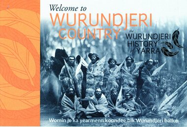
Booklet, Emily Fitzgerald et al, Welcome to Wurundjeri country: the Wurundjeri history of Yarra, 2014
... ...Wurundjeri Tribe Land Compensation and Cultural Heritage Council Incorporated...Welcome to Wurundjeri country: the Wurundjeri history of Yarra Booklet Booklet Emily Fitzgerald Yarra City Council Daniel Ducrou Wurundjeri Tribe Land Compensation and Cultural Heritage Council Incorporated ...Brief history of the Wurundjeri-willam people of the area now known as the City of Yarra, from pre-settlement times to the present.44p., paperback, printed in black and orange, illus.wurundjeri willam, city of yarra, aborigines - victoria -
 Eltham District Historical Society Inc
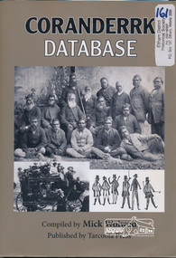
Book, Tarcoola Press, Coranderrk Database compiled by Mick Woiwod, 2012
... ...Wurundjeri Aboriginal Land Compensation and Cultural Heritage Council...Coranderrk Database compiled by Mick Woiwod Book Tarcoola Press Mick Woiwod Nillumbik Reconciliation Group Andrew Ross Museum Wurundjeri Aboriginal Land Compensation and Cultural Heritage Council ...Chronological timeline detailing activites at Coranderrk aboriginal station between 1867 and 1924. Accompanying CD rom at the back of the book. Sister publication to "Birrarung database." Winner of the Local History Project Award (for activities that enhance access to records of significance to local communities) as part of the Victorian Community History Awards 2012 242 pages : illustrations ; 30 cm + 1 CD-ROM (4 3/4 in.) PDF, Word files.ISBN 9780987157416coranderrk aboriginal station., australian aborginies, wurundjeri woi wurrung -
 Eltham District Historical Society Inc
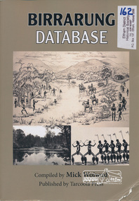
Book, Tarcoola Press, Birrarung Database compiled by Mick Woiwod, 2012
... ...Wurundjeri Aboriginal Land Compensation and Cultural Heritage Council...Birrarung Database compiled by Mick Woiwod Book Tarcoola Press Mick Woiwod Wurundjeri Aboriginal Land Compensation and Cultural Heritage Council Andrew Ross Museum Nillumbik Reconciliation Group ...A compilation of Woiwod's research material, with information on the history of the Wurundjeri people of the Yarra Valley, from the time of first European contact. Its prime focus is the Yarra River as it has been understood by its Wurundjeri people. Includes a compilation of those difficult to locate "brief snatches of the action" collated under headings with in each instance, the provenance as to source and / or author included. Themes include: agriculture, law, ceremony, language, reconciliation, retribution, lifestyle, art & craft, climate, personalities, disease, death and the river's flora and fauna. Sister publication to "Coranderrk database". 318 pages : illustrations, maps ; 30 cm + 1 CD-ROM (4 3/4 in.) PDF or Microsoft Office Word 97-2003.ISBN 9780987157423wurundjeri, yarra river, indigenous history, wurundjeri woi wurrung, aboriginal australians -
Canterbury History Group
Pamphlet - Heritage Trail official opening 2 March 2006, 2/03/2006
... ... Wurundjeri Land...Canterbury History Group 190A Canterbury Road Canterbury melbourne Canterbury Canterbury Primary School Molesworth Street Wurundjeri Land Primary Schools Leaflet/ invitation for the officail opening of the Heritage Trail at the Canterbury Primary School 2 March 2006 Pamphlet Heritage Trail official opening 2 March 2006 ...Leaflet/ invitation for the officail opening of the Heritage Trail at the Canterbury Primary School 2 March 2006canterbury, canterbury primary school, molesworth street, wurundjeri land, primary schools -
 Sunshine and District Historical Society Incorporated
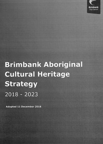
Document - Brimbank City Council Adopted Aboriginal Cultural Heritage Strategy 2018 - 2023, City of Brimbank, 2018
... This Strategy has been informed by consultation with the Wurundjeri Tribe Land and Compensation Cultural Heritage Council, Boon Wurrung Foundation / Yaluk-ut Weelam Elders council and the Bunurong Land Council Aboriginal Corporation....This Strategy has been informed by consultation with the Wurundjeri Tribe Land and Compensation Cultural Heritage Council, Boon Wurrung Foundation / Yaluk-ut Weelam Elders council and the Bunurong Land Council Aboriginal Corporation. ...This Strategy has been informed by consultation with the Wurundjeri Tribe Land and Compensation Cultural Heritage Council, Boon Wurrung Foundation / Yaluk-ut Weelam Elders council and the Bunurong Land Council Aboriginal Corporation.The City of Brimbank has within its boundaries some Aboriginal sites that are a significant part of the heritage of all Australians and are a fundamental part of Victorian Aboriginal community life and cultural identity.Brimbank City Council Adopted Aboriginal Cultural Heritage Strategy 2018 - 2023 Adopted 11 December 2018first nation, aboriginal -
Port Melbourne Historical & Preservation Society
Photograph - Rockery, newly planted garden area, Port Melbourne Uniting Church, Heather Wale, c. 2002
... One of four photos taken early 2003 of newly planted garden area in front of Port Melbourne Uniting Church, where a 2001 plaque acknowledges the traditional custodians of the land (Wurundjeri and Bunnerwrung peoples): rockery...Port Melbourne Historical & Preservation Society Port Melbourne Town Hall 333 Bay Street Port Melbourne melbourne Indigenous Australians Parks and Gardens Religion - Uniting Church Wurundjeri Bunnerwrung One of four photos taken early 2003 of newly planted garden area in front of Port Melbourne Uniting Church, where a 2001 plaque acknowledges the traditional custodians of the land (Wurundjeri and Bunnerwrung peoples): rockery Photograph Rockery, newly planted garden area, Port Melbourne Uniting Church Heather Wale ...One of four photos taken early 2003 of newly planted garden area in front of Port Melbourne Uniting Church, where a 2001 plaque acknowledges the traditional custodians of the land (Wurundjeri and Bunnerwrung peoples): rockeryindigenous australians, parks and gardens, religion - uniting church, wurundjeri, bunnerwrung -
Port Melbourne Historical & Preservation Society
Photograph - Plaque, newly planted garden area, Port Melbourne Uniting Church, Heather Wale, c. 2002
... One of four photos taken early 2003 of newly planted garden area in front of Port Melbourne Uniting Church, where a 2001 plaque acknowledges the traditional custodians of the land (Wurundjeri and Bunnerwrung peoples): plaque...Port Melbourne Historical & Preservation Society Port Melbourne Town Hall 333 Bay Street Port Melbourne melbourne Indigenous Australians Parks and Gardens Religion - Uniting Church Wurundjeri Bunnerwrung One of four photos taken early 2003 of newly planted garden area in front of Port Melbourne Uniting Church, where a 2001 plaque acknowledges the traditional custodians of the land (Wurundjeri and Bunnerwrung peoples): plaque Photograph Plaque, newly planted garden area, Port Melbourne Uniting Church Heather Wale ...One of four photos taken early 2003 of newly planted garden area in front of Port Melbourne Uniting Church, where a 2001 plaque acknowledges the traditional custodians of the land (Wurundjeri and Bunnerwrung peoples): plaqueindigenous australians, parks and gardens, religion - uniting church, wurundjeri, bunnerwrung -
Port Melbourne Historical & Preservation Society
Photograph - Rockery, newly planted garden area, Port Melbourne Uniting Church, Heather Wale, c. 2002
... One of four photos taken early 2003 of newly planted garden area in front of Port Melbourne Uniting Church, where a 2001 plaque acknowledges the traditional custodians of the land (Wurundjeri and Bunnerwrung peoples): rockery, close-up...Port Melbourne Historical & Preservation Society Port Melbourne Town Hall 333 Bay Street Port Melbourne melbourne Indigenous Australians Parks and Gardens Religion - Uniting Church Wurundjeri Bunnerwrung One of four photos taken early 2003 of newly planted garden area in front of Port Melbourne Uniting Church, where a 2001 plaque acknowledges the traditional custodians of the land (Wurundjeri and Bunnerwrung peoples): rockery, close-up Photograph Rockery, newly planted garden area, Port Melbourne Uniting Church Heather Wale ...One of four photos taken early 2003 of newly planted garden area in front of Port Melbourne Uniting Church, where a 2001 plaque acknowledges the traditional custodians of the land (Wurundjeri and Bunnerwrung peoples): rockery, close-upindigenous australians, parks and gardens, religion - uniting church, wurundjeri, bunnerwrung -
Port Melbourne Historical & Preservation Society
Photograph - Plaque, newly planted garden area, Port Melbourne Uniting Church, Heather Wale, c. 2002
... One of four photos taken early 2003 of newly planted garden area in front of Port Melbourne Uniting Church, where a 2001 plaque acknowledges the traditional custodians of the land (Wurundjeri and Bunnerwrung peoples): plaque close-up...Port Melbourne Historical & Preservation Society Port Melbourne Town Hall 333 Bay Street Port Melbourne melbourne Indigenous Australians Parks and Gardens Religion - Uniting Church Wurundjeri Bunnerwrung One of four photos taken early 2003 of newly planted garden area in front of Port Melbourne Uniting Church, where a 2001 plaque acknowledges the traditional custodians of the land (Wurundjeri and Bunnerwrung peoples): plaque close-up Photograph Plaque, newly planted garden area, Port Melbourne Uniting Church Heather Wale ...One of four photos taken early 2003 of newly planted garden area in front of Port Melbourne Uniting Church, where a 2001 plaque acknowledges the traditional custodians of the land (Wurundjeri and Bunnerwrung peoples): plaque close-upindigenous australians, parks and gardens, religion - uniting church, wurundjeri, bunnerwrung -
 Sunbury Family History and Heritage Society Inc.
Photograph, Rosa McCall, Sunbury Cultural Ring, May 2018
... They are owned and managed by the Wurundjeri Tribe Land Council....They are owned and managed by the Wurundjeri Tribe Land Council. The rings bear evidence of Aboriginal settlement and land use in the area. ...The photograph is of one of the Sunbury Cultural Rings sites. There are three Aboriginal earthen rings. The one in the foreground which is clear of weeds has been formed as a round dip in the earth and it is thought it was used as an Aboriginal gathering place. They are owned and managed by the Wurundjeri Tribe Land Council.The rings bear evidence of Aboriginal settlement and land use in the area. A coloured landscape photograph of open grassland and hills across the valley with a few native trees growing . aboriginal cultural rings, sunbury, jacksons creek, wurundjeri people -
 Emerald Museum & Nobelius Heritage Park
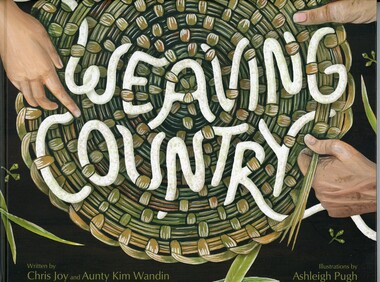
Book, Chris Joy and Aunty Kim Wandin et al, Weaving Country, 2025
... The Wurundjeri Woi-wurrung people are the traditional owners of the land on which the Emerald Museum is situated. ...This is a story about Aunty Kim teaching her granddaughter to weave which includes understanding and caring for Country.Children's book with color illustrations and text. 30 pages.fictionThis is a story about Aunty Kim teaching her granddaughter to weave which includes understanding and caring for Country.wurundjeri woi-wurrung -
 Orbost & District Historical Society
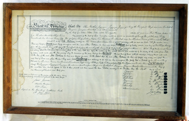
framed document, Batman's Melbourne Deed, 1966
... Batman's Treaty was a document signed on 6 June 1835 by John Batman, an Australian grazier, businessman and explorer, and a group of Wurundjeri elders, for the purchase of land around Port Phillip, near the present site of the city of Melbourne. ...Batman's Treaty was a document signed on 6 June 1835 by John Batman, an Australian grazier, businessman and explorer, and a group of Wurundjeri elders, for the purchase of land around Port Phillip, near the present site of the city of Melbourne. ...The Batman Deed is sometimes called the Batman Treaty, the Dutigullar Deed, the Dutigullar Treaty or the Melbourne Deed. The deeds had been drafted by JT Gellibrand, a leading lawyer in the colony. Batman's Treaty was a document signed on 6 June 1835 by John Batman, an Australian grazier, businessman and explorer, and a group of Wurundjeri elders, for the purchase of land around Port Phillip, near the present site of the city of Melbourne. The document came to be known as Batman's Treaty and is considered significant as it was the first and only documented time when Europeans negotiated their presence and occupation of Aboriginal lands directly with the traditional owners. The so-called treaty was implicitly declared void on 26 August 1835 by the Governor of New South Wales, Richard Bourke. The original Batman Deed is of enormous significance to the history of the European settlement of Victoria. Framed print of the Batman Deed, dated 1835. This is a printed copy of the Batman Deed, made in 1966 from the 'original' by the State Library of Victoria. The frame is wood. The document consists of handwritten text in black ink with eight signatures in the lower right hand side and three signatures in the lower left hand corner. It has been signed by John Batman beneath the eight signatures.document batman-deed melbourne -
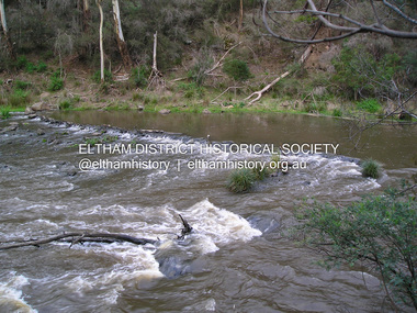
 Eltham District Historical Society Inc
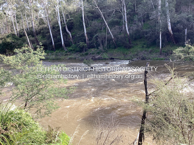
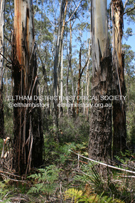
Photograph, Fay Bridge, Ancient Eel trap on the Yarra River at Laughing Waters, Eltham - pre-dating European settlement, 6 September 2023
... Wurundjeri are the ‘Manna Gum People’ and their Ancestors have lived on this land for millennia. ...Wurundjeri are the ‘Manna Gum People’ and their Ancestors have lived on this land for millennia. ...Laughing Waters is the name for a stretch of the Yarra Valley Parklands consisting of river flats and hilly riparian bushland. With Birrarung (Yarra River) flowing through, Laughing Waters has been an important gathering place for thousands of years. For the Wurundjeri, ‘Garambi Baan’ (the name for Laughing Waters in Woi wurrung) is an important site for growing and harvesting food. Significantly, Wurundjeri iuk (eel) traps remain at Garambi Baan to this day. The Wurundjeri Woi Wurrung People take their name from the Woi wurrung language word ‘wurun’ meaning the Manna Gum (Eucalyptus viminalis) which is common along ‘Birrarung’ (Yarra River), and ‘djeri’, the grub which is found in or near the tree. Wurundjeri are the ‘Manna Gum People’ and their Ancestors have lived on this land for millennia. The site on the Yarra River near the former Morrison property Killeavey was given a language name in 2015 at the instigation of Wurundjeri Elder, Dave Wandin. Garambi Baan means “laughing waters” in the traditional language, Woi wurrung. The site at Warrandyte was rediscovered by Campbell Beardsell OAM in 2007 and is one of only a few known remaining iuk (eel) traps on Country once found the length of the Birrarung (Yarra) and the Maribyrnong. Original Indigenous aquacultural infrastructure was dismantled, taken away from sites and used to build houses, fords and roads by Europeans. The difficult and restricted access to this site is thought to be one of the reasons for its survival. The iuk trap is located within lands managed by Parks Victoria. The Narrap team in partnership with Parks Victoria and Acacia Land Management have been improving the native vegetation with a program of woody weed removal, exclusion fencing and revegetation. Importantly, the team have restored the trap’s infrastructure and have demonstrated its effectiveness.” References: Wurundjeri Woi Wurrung Cultural Heritage Aboriginal Corporation - Laughing Waters. (2023, September 3). Retrieved from https://inplace.org.au/laughing-waters/ GARAMBI BAAN LAUGHING WATERS RESIDENCY CENTRE 2020 2024 Strategic Plan, Nillumbik Shire Council (2023, September 3). Retrieved from https://www.nillumbik.vic.gov.au/files/assets/public/minutes-and-agendas/2020/09-sep/15-sep-cm/ocm.177-20-attachment-1-laughing-waters-arts-program_1.pdffay bridge collection, eel trap, laughing waters, yarra river, wurundjeri woi wurrung, garambi baan, 2023-09-06 -
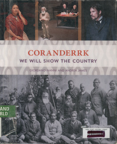 Eltham District Historical Society Inc
Book, Giordano Nanni et al, Coranderrk; We will show the country, 2013
... land rights and self-determination in colonial Australia was undertaken by the Aboriginal people of Coranderrk reserve in central Victoria. Despite having created an award-winning farm they were targeted for removal to make way for white settlement. As skilled communicators and negotiators, they lobbied the government, in alliance with their white supporters, and succeeded in triggering a Parliamentary Inquiry in 1881. Coranderrk – We Will Show The Country derives from a unique verbatim-theatre performance where professional actors brought to life the witnesses who gave evidence before the 1881 Parliamentary Coranderrk Inquiry. Rescued from dusty archives, and including renowned Wurundjeri...land rights and self-determination in colonial Australia was undertaken by the Aboriginal people of Coranderrk reserve in central Victoria. Despite having created an award-winning farm they were targeted for removal to make way for white settlement. As skilled communicators and negotiators, they lobbied the government, in alliance with their white supporters, and succeeded in triggering a Parliamentary Inquiry in 1881. Coranderrk – We Will Show The Country derives from a unique verbatim-theatre performance where professional actors brought to life the witnesses who gave evidence before the 1881 Parliamentary Coranderrk Inquiry. Rescued from dusty archives, and including renowned Wurundjeri ...Comprises twenty-three extracts from the Minutes of Evidence of the Coranderrk Inquiry, accompanied by an analysis of the historical text and context. The book relies strongly on primary-source materials and accurately references historical analysis from scholarly and Aboriginal perspectives. This book is derived from a verbatim-theatre performance in which professional actors portrayed the witnesses who gave evidence before the 1881 Coranderrk Inquiry.; Inscriptions and Markings: illustrations, photographs, facsimiles, maps, portraits About the book One of the first sustained campaigns for justice, land rights and self-determination in colonial Australia was undertaken by the Aboriginal people of Coranderrk reserve in central Victoria. Despite having created an award-winning farm they were targeted for removal to make way for white settlement. As skilled communicators and negotiators, they lobbied the government, in alliance with their white supporters, and succeeded in triggering a Parliamentary Inquiry in 1881. Coranderrk – We Will Show The Country derives from a unique verbatim-theatre performance where professional actors brought to life the witnesses who gave evidence before the 1881 Parliamentary Coranderrk Inquiry. Rescued from dusty archives, and including renowned Wurundjeri leader, William Barak, those witnesses continue to speak to contemporary audiences. Here, their powerful petitioning can be read alongside that of their non-Aboriginal allies, and those who would move them off their land. The book features a concise and accessible history of the Coranderrk Aboriginal Station and of the events that led to the appointment of the 1881 Parliamentary Coranderrk Inquiry. The book also contains a special edition of the verbatim script which has been annotated and referenced so as to provide a blueprint of how the original minutes of evidence from the 1881 Parliamentary Coranderrk Inquiry were adapted into a theatre script. Each scene of the play has also been introduced with a short biography of each character and a discussion of the key themes raised in their testimony. Supplementing the verbatim script of the performance, the book includes a range of historical images and stills from the ILBIJERRI Theatre Company’s production. Coranderrk – We Will Show The Country celebrates the spirit of collaboration between black and white in pursuit of justice, and offers an engaging way to learn about our past – and to think about our future. Coranderrk - We Will Show The Country. (2023, October 19). Retrieved from http://www.minutesofevidence.com.au/education/coranderrk-we-will-show-the-country-book/Ex Yarra Plenty Regional Library copyaboriginal australians, coranderrk, first nations people, healesville, indigenous history, performance, play -
Eltham District Historical Society Inc
Document - Folder, Newman, Charles
... Wurundjeri Clan of the Kulin". Whitehorse Manningham Heritage Network search results for "Andersons Station on the Yarra Yarra", "A brief history of Warrandyte", "The branch is broken", "Melbourne's historic home", "Land with infamous past", "Charles Newman's original grave at Monckton", and "Site of Major Newman's land". ...Wurundjeri Clan of the Kulin". Whitehorse Manningham Heritage Network search results for "Andersons Station on the Yarra Yarra", "A brief history of Warrandyte", "The branch is broken", "Melbourne's historic home", "Land with infamous past", "Charles Newman's original grave at Monckton", and "Site of Major Newman's land". ...British army officer Major Charles Newman was an early settler on the Yarra River at Templestowe after serving in India in the East India Company. Later be married and moved to Tasmania, farming at Black Brush near Pontville. In 1835 he came to the Port Phillip District and explored the Yarra River, returning with his family. David Crockett and Hazel Poulter researched, respectively, Charles Newman and the Templestowe area, identifying the Newman house, Pontville, on the Yarra banks. David Crockett also researched James and Anne Anderson. Contents Newspaper article: "David fills in the gaps", Diamond Valley News, 16 December 1986.29 October 1985, p62. Story of Charles Newman and of David Crockett and Hazel Poulter's researches. Letter, A (Tony) B Owen to Eltham Historical Society, 12 March 2018, enclosing information about Major Charles Newman. Email, Eltham District Historical Society to Tony Owen, acknowledging receipt of information about Major Charles Newman. Photocopy of pages from "Glimpses of Life in Victoria", pp38-43. Flier, "Heritage Events in Nillumbik, 2005". Photocopy of pages from unidentified volume, chapter headed "The Bush", and part chapter IV "Bushrangers". Warrandyte Historical Society publication "The Wurundjeri Clan of the Kulin". Whitehorse Manningham Heritage Network search results for "Andersons Station on the Yarra Yarra", "A brief history of Warrandyte", "The branch is broken", "Melbourne's historic home", "Land with infamous past", "Charles Newman's original grave at Monckton", and "Site of Major Newman's land". Photocopy of pages from "Templestowe - a folk history", Hazel Poulter, 1985,: "The squatter, Major Charles Newman".Newspaper clippings, A4 photocopies, etccharles newman, british east india company, templestowe vic, warrandyte vic, david crockett, hazel poulter, james anderson, anne anderdon, a b owen, wurundjeri clan of the kulin, andersons station on the yarra river -
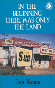 Eltham District Historical Society Inc
Book, Len Kenna, In the beginning there was only the land, 1988
... Bundoora Bundoora Hall Hospitals Jane McKimmie Janefield Janefield Church john mckimmie La Trobe University Marvellous Melbourne Mont Park Mont Park Psychiatric Hospital Plenty River william shillinglaw Wurundjeri Yan Yean Reservoir Softback; 227 p. : ill., facsims., maps, ports. ; 22 cm. In the beginning there was only the land Book Len Kenna Lions Club of Bundoora ...A book, published as part of the Australian Bicentenary Celebrations on the history of the suburb of Bundoora. ... Includes photographs, maps and index. Local history of the outer Melbourne suburb of Bundoora, from the original Wurundjeri people through to its development as a thriving suburb in the 1980s ; section entitled "The Aborigines" (pp.14-21) discusses the traditional way of life of the Wurundjeri people prior to European settlement.bundoora, bundoora hall, hospitals, jane mckimmie, janefield, janefield church, john mckimmie, la trobe university, marvellous melbourne, mont park, mont park psychiatric hospital, plenty river, william shillinglaw, wurundjeri, yan yean reservoir -
 Eltham District Historical Society Inc
Photograph - Digital Photograph, Alan King, Golden King Mine poppet-head, Yarrambat Primary School, 1 February 2008
... land, the corner became known as Tanck’s Corner. In 1929 the district’s name was changed to Yarrambat, believed to mean ‘high hill’ in the Wurundjeri language. ...land, the corner became known as Tanck’s Corner. In 1929 the district’s name was changed to Yarrambat, believed to mean ‘high hill’ in the Wurundjeri language. ...The Golden King Mine poppet-head stands at the school’s Yan Yean Road exit gate. Published: Nillumbik Now and Then / Marguerite Marshall 2008; photographs Alan King with Marguerite Marshall.; p23 Early Yarambat - Tanck's Corner Its early settlers, who in the 1840s were amongst the first non-Aboriginal people in the area, found life tough as they grazed their sheep and cattle. Yarrambat was then known as Tanck’s Corner or Reynolds Corner, after wood carter, Frederick Tanck, who owned land north of Ironbark Road, at the corner of Yan Yean Road, and Thomas Reynolds, owner of the opposite property. After Reynolds sold his land, the corner became known as Tanck’s Corner. In 1929 the district’s name was changed to Yarrambat, believed to mean ‘high hill’ in the Wurundjeri language. Tanck’s Corner was in the centre of gold-bearing country and the district is honeycombed with old tunnels and shafts. However although gold played a dominant role for decades, there was insufficient to develop a substantial township. Meat and agricultural produce made a greater impact. Until the mid-20th century the only substantial building was the primary school. The first gold rush occurred around 1860, the second after 1900; then during the Depression, the Government paid men to pan for gold. The first rush attracted hundreds of Chinese people to Smugglers Gully, who constructed round diggings to keep away spirits. Alluvial miners lived along the Plenty River in tents or humpies - some fenced with gardens - and some miners distilled their own ‘plonk’. It was a wild time and bushrangers - and later gangster Squizzy Taylor - were said to hide4 in the old Pioneer Tunnel in Dunne’s Gully between Heard Avenue and Pioneer Road. Mines opposite Tanck’s Corner included Beer’s Line, Golden Crown and Golden Stairs. Some of the big mines had batteries and stampers to process quartz. At first there was plenty of alluvial gold, as much as two ounces to the ton. At times gold was exposed after heavy rains so fossickers panned for gold around orchard irrigation trenches. Gold was mined until 1984 when Yarrambat’s last operating goldmine, the Golden King Mine, in North Oatlands Road, closed. The Clayton family operated it full-time, making a comfortable living and in the 1960s it was the only private family gold mine in Victoria.5 Gold was such an important part of Yarrambat’s history that a gold poppet-head is the Yarrambat Primary School’s logo. The Golden King Mine poppet-head stands at the school’s Yan Yean Road exit gate. However this school was built in 1988. The original school No 2054, at the corner of Ironbark and Yan Yean Roads, was opened in 1878 and modified to its present form in the 1920s. In 2000 it was relocated to the Heritage Museum at Yarrambat Park.7 The school, whose first head teacher was Charles Planner, consisted of one room with a three-roomed residence. The school was also the community centre. On Saturday nights it was crammed for dances or euchre parties, community singing or other social events. On Sundays, services for different denominations took turns each week. However the school had its teething problems. Parents accused Charles Planner of neglecting his duties and the school closed several times. When it closed in 1892, only church services continued. Social activities moved elsewhere, such as the tennis club to the Stuchbery tennis court opposite. A sports day and woodchop on Boxing Day around 1900 was held at the Evelyn Hill Hotel, also called Evelyn Arms and Tunnel Hill Hotel, on the Greensborough–Diamond Creek Road. An annual agricultural show in Diamond Creek paraded through the town, and New Year’s Day picnics at the Yan Yean Reservoir included highland dancing and competitions. Also popular were the Indian hawkers who visited every three months, selling trinkets, clothing and other items. One called Jimmy ‘Allem dem Bedi’, gave presents and told stories, played draughts and sold delicious curries he cooked over his camp fire at night.This collection of almost 130 photos about places and people within the Shire of Nillumbik, an urban and rural municipality in Melbourne's north, contributes to an understanding of the history of the Shire. Published in 2008 immediately prior to the Black Saturday bushfires of February 7, 2009, it documents sites that were impacted, and in some cases destroyed by the fires. It includes photographs taken especially for the publication, creating a unique time capsule representing the Shire in the early 21st century. It remains the most recent comprehenesive publication devoted to the Shire's history connecting local residents to the past. nillumbik now and then (marshall-king) collection, golden king mine, tanck's corner, yarrambat primary school -
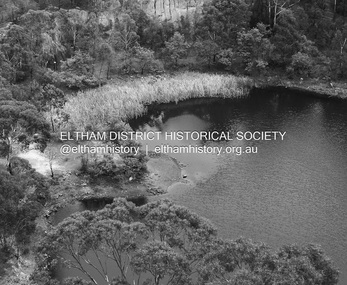
 Eltham District Historical Society Inc
Photograph - Digital Photograph, Marguerite Marshall, Eltham Lower Park, 20 April 2008
... Eltham Lower Park, with other parks, forms an almost continuous green band from Eltham’s centre, along the Diamond Creek to the Yarra River.1 Before European settlement the Wurundjeri people met on this land, particularly at the junction of the Diamond Creek with the Yarra River, which they called Birr-arung. ...Eltham Lower Park, with other parks, forms an almost continuous green band from Eltham’s centre, along the Diamond Creek to the Yarra River.1 Before European settlement the Wurundjeri people met on this land, particularly at the junction of the Diamond Creek with the Yarra River, which they called Birr-arung. ...Originally a race course, the park has brought the community together with a variety of activities. Published: Nillumbik Now and Then / Marguerite Marshall 2008; photographs Alan King with Marguerite Marshall.; p45 Once used for horse racing, which attracted visitors from Melbourne, the Eltham Lower Park has brought the community together with a wide range of activities. Horse riding is now enjoyed as a recreation in the park as are other sports. The park also includes the Diamond Valley Railway miniature trains and a sanctuary for the rare and vulnerable Eltham Copper Butterfly. Eltham Lower Park, with other parks, forms an almost continuous green band from Eltham’s centre, along the Diamond Creek to the Yarra River.1 Before European settlement the Wurundjeri people met on this land, particularly at the junction of the Diamond Creek with the Yarra River, which they called Birr-arung. This is commemorated by the sculpture, Not just a Pretty Place by Aleks Danko, winner of the 2000 Nillumbik Art in Public Places Award. The first European to settle here was probably Henry Foley, who in 1841 used it as part of his pastoral run. Foley sold his leasehold to Joseph Wilson in 1845, who soon after sold it to Frederick Falkiner. During the 1840s the future park was part of a government square mile (2.6 sqkm) reserve, north of the Yarra, within the Parish of Nillumbik, later named Eltham. Soon the land was used for horse racing after nearby residents cleared ten acres (4ha) in the early 1850s. A three-quarter of a mile (1.2km) race secured the winner the £10 Publican’s Prize. In response to popular demand, the newly formed Eltham District Road Board petitioned the Surveyor General of the Colony of Victoria, in 1856, for 36 acres (14.6ha) of crown land for a racecourse and recreation. By 1858 the Eltham races had become an institution. ‘Many skirmishes occurred and the way home was paved with temptation, with sly-grog for sale.3 In the early 1870s, two jockeys were sons of the police officer in charge of the Eltham Police Station, Miles S Lyons. Another ten acres (4ha) was added to the area in 1866 and 12 acres (4.8ha) – Hohnes Hill – in 1870. In 1866, two acres (0.8ha) on the creek banks became an animal pound with William Walsh the pound keeper in 1870, but this was later incorporated into the park. By 1877 the area was called a public park but horse racing and training continued into the 1920s. In the mid-1900s trotters were trained on a circuit road. In 1953 the Eltham Pony Club was established and used a cross-country course on Hohnes Hill. From the mid 1950s the club held the Eltham Easter Fair at the park, later to include a procession along Main Road from the town centre to the park. The park also attracted picnic parties and campers from the inner suburbs as did Wingrove Park, and businesses catering for visitors, sprang up on the opposite side of Main Road. Bus-loads of school children visited the park for Gould League bird days in the 1960s. In 1979 the Eltham Shire Council bought Lenister Farm, linking the park with the Yarra River. The Lenister Farm wetland includes a bird hide, viewing platform and interpretive signs.5 Pioneer Henry Stooke, later Road Board chairman, bought the 11 acres (4.5ha) - later to become Lenister Farm - from the Crown in 1862. Stooke never lived on this site and the two houses at Lenister Farm were built in the 20th century. Since its formation in 1871, the Council has controlled this crown land, which it named Eltham Park. But in the 1920s Eltham Council bought land near the town centre for a park, which it named Eltham Central Park. To avoid confusion the Council renamed Eltham Park, Eltham Lower Park. Since 2004 the Yarra footbridge has linked the park with the Yarra Valley Metropolitan Park and the Main Yarra Trail.This collection of almost 130 photos about places and people within the Shire of Nillumbik, an urban and rural municipality in Melbourne's north, contributes to an understanding of the history of the Shire. Published in 2008 immediately prior to the Black Saturday bushfires of February 7, 2009, it documents sites that were impacted, and in some cases destroyed by the fires. It includes photographs taken especially for the publication, creating a unique time capsule representing the Shire in the early 21st century. It remains the most recent comprehenesive publication devoted to the Shire's history connecting local residents to the past. nillumbik now and then (marshall-king) collection, eltham lower park, eltham park -
 Eltham District Historical Society Inc
Photograph - Digital Photograph, Alan King, Blue Lake, Plenty Gorge Park, 2008
... The area’s plentiful food and water attracted the Wurundjeri Aboriginal people and then European settlers. By 1837 squatters had claimed large runs of land for their sheep and cattle. ...The area’s plentiful food and water attracted the Wurundjeri Aboriginal people and then European settlers. By 1837 squatters had claimed large runs of land for their sheep and cattle. ...A quarry was transformed into the Blue Lake. Published: Nillumbik Now and Then / Marguerite Marshall 2008; photographs Alan King with Marguerite Marshall.; p179 The dramatic steep-sided Plenty Gorge lies along the divide of two geological areas, and separates the Nillumbik Shire and the City of Whittlesea. On the Nillumbik side are undulating hills and sedimentary rock, and in Whittlesea, lies a basalt plain formed by volcanic action up to two million years ago. This provides the Plenty Gorge Park with diverse vegetation and habitats, making it one of Greater Melbourne’s most important refuges for threatened and significant species. The park, established in 1986, consists of around 1350 hectares, and extends 11 kilometres along the Plenty River, from Greensborough to Mernda. It provides a wildlife corridor for around 500 native plant and 280 animal species. The area’s plentiful food and water attracted the Wurundjeri Aboriginal people and then European settlers. By 1837 squatters had claimed large runs of land for their sheep and cattle. The Plenty Valley was among the first in the Port Phillip District to be settled - mainly in the less heavily timbered west - and was proclaimed a settled district in 1841.But by the late 1880s, the settlers’ extensive land clearing for animal grazing, then agriculture, depleted the Wurundjeri’s traditional food sources, which helped to drive them away. Many Wurundjeri artefacts remain (now government protected), and so far 57 sites have been identified in the park, including scarred trees, burial areas and stone artefacts. Pioneer life could be very hard because of isolation, flooding, bushfires and bushrangers. Following the Black Thursday bushfires of 1851, basalt was quarried to build more fire-resistant homes. Gold discoveries in the early 1850s swelled the population, particularly around Smugglers Gully; but food production made more of an impact. In the late 1850s wheat production supplanted grazing. In the 1860s the government made small holdings available to poorer settlers. These had the greatest effect on the district, particularly in Doreen and Yarrambat, where orchards were established from the 1880s to 1914. Links with a prominent early family are the remains of Stuchbery Farm, by the river’s edge bounded by Smugglers Gully to the north and La Trobe Road, Yarrambat, to the east. The Stuchberys moved to the valley in 1890, and the family still lives in the area. In 1890, Alfred and Ada first lived in a tent where four children were born, then Alfred built the house and outbuildings around 1896. They planted an orchard, then a market garden, and developed a dairy. The family belonged to the local Methodist and tennis communities. Their grandson Walter, opened the Flying Scotsman Model Railway Museum in Yarrambat, which his widow, Vi, continues to run. Wal was also the Yarrambat CFA Captain for 22 years until 1987. Walter sold 24 hectares in 1976 for development - now Vista Court - and in 1990, the remaining 22.6 hectares for the park. Remaining are an early stone dairy and remnants of a stone barn, a pig sty and a well. Until it was destroyed by fire in 2003, a slab hut stood on the Happy Hollow Farm site, at the southern end of the park. The hut is thought to have been built in the Depression around 1893. This was a rare and late example of a slab hut with a domestic orchard close to Melbourne. Emmet Watmough and his family first occupied the hut, followed by a succession of families, until the Bell family bought it around 1948. There they led a subsistence lifestyle for 50 years, despite encroaching Melbourne suburbia. The Yellow Gum Recreation Area includes the Blue Lake, coloured turquoise at certain times of the year. Following the 1957 bushfires, this area was quarried by Reid Quarries Pty Ltd for Melbourne’s first skyscrapers, then by Boral Australia. However in the early 1970s water began seeping into the quarry forming the Blue Lake and the quarry was closed. The State Government bought the site in 1997 and opened it as a park in 1999.This collection of almost 130 photos about places and people within the Shire of Nillumbik, an urban and rural municipality in Melbourne's north, contributes to an understanding of the history of the Shire. Published in 2008 immediately prior to the Black Saturday bushfires of February 7, 2009, it documents sites that were impacted, and in some cases destroyed by the fires. It includes photographs taken especially for the publication, creating a unique time capsule representing the Shire in the early 21st century. It remains the most recent comprehenesive publication devoted to the Shire's history connecting local residents to the past. nillumbik now and then (marshall-king) collection, blue lake, plenty gorge park -
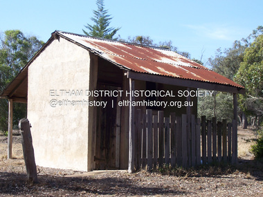 Eltham District Historical Society Inc
Photograph - Digital Photograph, Marguerite Marshall, Stuchbery Farm dairy, 14 March 2008
... The area’s plentiful food and water attracted the Wurundjeri Aboriginal people and then European settlers. By 1837 squatters had claimed large runs of land for their sheep and cattle. ...The area’s plentiful food and water attracted the Wurundjeri Aboriginal people and then European settlers. By 1837 squatters had claimed large runs of land for their sheep and cattle. ...Stuchbery Farm was situated on the Plenty River bounded by Smugglers Gully to the north and La trobe Road, Yarrambat, to the east. Alan and Ada Stutchbery moved to the valley in 1890, first living in a tent where four children were born. Alfred built a home and outbuildings around 1896. They planted an orchard, then a market garden and developed a dairy. Published: Nillumbik Now and Then / Marguerite Marshall 2008; photographs Alan King with Marguerite Marshall.; p179 The dramatic steep-sided Plenty Gorge lies along the divide of two geological areas, and separates the Nillumbik Shire and the City of Whittlesea. On the Nillumbik side are undulating hills and sedimentary rock, and in Whittlesea, lies a basalt plain formed by volcanic action up to two million years ago. This provides the Plenty Gorge Park with diverse vegetation and habitats, making it one of Greater Melbourne’s most important refuges for threatened and significant species. The park, established in 1986, consists of around 1350 hectares, and extends 11 kilometres along the Plenty River, from Greensborough to Mernda. It provides a wildlife corridor for around 500 native plant and 280 animal species. The area’s plentiful food and water attracted the Wurundjeri Aboriginal people and then European settlers. By 1837 squatters had claimed large runs of land for their sheep and cattle. The Plenty Valley was among the first in the Port Phillip District to be settled - mainly in the less heavily timbered west - and was proclaimed a settled district in 1841. But by the late 1880s, the settlers’ extensive land clearing for animal grazing, then agriculture, depleted the Wurundjeri’s traditional food sources, which helped to drive them away. Many Wurundjeri artefacts remain (now government protected), and so far 57 sites have been identified in the park, including scarred trees, burial areas and stone artefacts. Pioneer life could be very hard because of isolation, flooding, bushfires and bushrangers. Following the Black Thursday bushfires of 1851, basalt was quarried to build more fire-resistant homes. Gold discoveries in the early 1850s swelled the population, particularly around Smugglers Gully; but food production made more of an impact. In the late 1850s wheat production supplanted grazing. In the 1860s the government made small holdings available to poorer settlers. These had the greatest effect on the district, particularly in Doreen and Yarrambat, where orchards were established from the 1880s to 1914. Links with a prominent early family are the remains of Stuchbery Farm, by the river’s edge bounded by Smugglers Gully to the north and La Trobe Road, Yarrambat, to the east. The Stuchberys moved to the valley in 1890, and the family still lives in the area. In 1890, Alfred and Ada first lived in a tent where four children were born, then Alfred built the house and outbuildings around 1896. They planted an orchard, then a market garden, and developed a dairy. The family belonged to the local Methodist and tennis communities. Their grandson Walter, opened the Flying Scotsman Model Railway Museum in Yarrambat, which his widow, Vi, continues to run. Wal was also the Yarrambat CFA Captain for 22 years until 1987. Walter sold 24 hectares in 1976 for development - now Vista Court - and in 1990, the remaining 22.6 hectares for the park. Remaining are an early stone dairy and remnants of a stone barn, a pig sty and a well. Until it was destroyed by fire in 2003, a slab hut stood on the Happy Hollow Farm site, at the southern end of the park. The hut is thought to have been built in the Depression around 1893. This was a rare and late example of a slab hut with a domestic orchard close to Melbourne. Emmet Watmough and his family first occupied the hut, followed by a succession of families, until the Bell family bought it around 1948. There they led a subsistence lifestyle for 50 years, despite encroaching Melbourne suburbia. The Yellow Gum Recreation Area includes the Blue Lake, coloured turquoise at certain times of the year. Following the 1957 bushfires, this area was quarried by Reid Quarries Pty Ltd for Melbourne’s first skyscrapers, then by Boral Australia. However in the early 1970s water began seeping into the quarry forming the Blue Lake and the quarry was closed. The State Government bought the site in 1997 and opened it as a park in 1999.This collection of almost 130 photos about places and people within the Shire of Nillumbik, an urban and rural municipality in Melbourne's north, contributes to an understanding of the history of the Shire. Published in 2008 immediately prior to the Black Saturday bushfires of February 7, 2009, it documents sites that were impacted, and in some cases destroyed by the fires. It includes photographs taken especially for the publication, creating a unique time capsule representing the Shire in the early 21st century. It remains the most recent comprehenesive publication devoted to the Shire's history connecting local residents to the past. nillumbik now and then (marshall-king) collection, ada stuchbery, alan stuchbery, dairy, stuchbery farm, farm buildings, yarrambat, plenty gorge park -
 Eltham District Historical Society Inc
Photograph, Fay Bridge, Ancient Eel trap on the Yarra River at Laughing Waters, Eltham - pre-dating European settlement, 16 May 2015
... Wurundjeri are the ‘Manna Gum People’ and their Ancestors have lived on this land for millennia. ...Wurundjeri are the ‘Manna Gum People’ and their Ancestors have lived on this land for millennia. ...Laughing Waters is the name for a stretch of the Yarra Valley Parklands consisting of river flats and hilly riparian bushland. With Birrarung (Yarra River) flowing through, Laughing Waters has been an important gathering place for thousands of years. For the Wurundjeri, ‘Garambi Baan’ (the name for Laughing Waters in Woi wurrung) is an important site for growing and harvesting food. Significantly, Wurundjeri iuk (eel) traps remain at Garambi Baan to this day. The Wurundjeri Woi Wurrung People take their name from the Woi wurrung language word ‘wurun’ meaning the Manna Gum (Eucalyptus viminalis) which is common along ‘Birrarung’ (Yarra River), and ‘djeri’, the grub which is found in or near the tree. Wurundjeri are the ‘Manna Gum People’ and their Ancestors have lived on this land for millennia. The site on the Yarra River near the former Morrison property Killeavey was given a language name in 2015 at the instigation of Wurundjeri Elder, Dave Wandin. Garambi Baan means “laughing waters” in the traditional language, Woi wurrung. The site at Warrandyte was rediscovered by Campbell Beardsell OAM in 2007 and is one of only a few known remaining iuk (eel) traps on Country once found the length of the Birrarung (Yarra) and the Maribyrnong. Original Indigenous aquacultural infrastructure was dismantled, taken away from sites and used to build houses, fords and roads by Europeans. The difficult and restricted access to this site is thought to be one of the reasons for its survival. The iuk trap is located within lands managed by Parks Victoria. The Narrap team in partnership with Parks Victoria and Acacia Land Management have been improving the native vegetation with a program of woody weed removal, exclusion fencing and revegetation. Importantly, the team have restored the trap’s infrastructure and have demonstrated its effectiveness.” References: Wurundjeri Woi Wurrung Cultural Heritage Aboriginal Corporation - Laughing Waters. (2023, September 3). Retrieved from https://inplace.org.au/laughing-waters/ GARAMBI BAAN LAUGHING WATERS RESIDENCY CENTRE 2020 2024 Strategic Plan, Nillumbik Shire Council (2023, September 3). Retrieved from https://www.nillumbik.vic.gov.au/files/assets/public/minutes-and-agendas/2020/09-sep/15-sep-cm/ocm.177-20-attachment-1-laughing-waters-arts-program_1.pdffay bridge collection, 2015-05-16, eel trap, laughing waters, yarra river, wurundjeri woi wurrung, garambi baan -
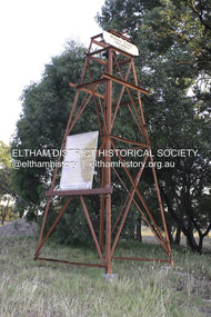
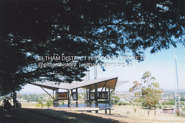 Eltham District Historical Society Inc
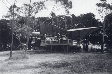
Photograph, Fay Bridge, Moor-rul Viewing Platform, Garden Hill, Kangaroo Ground, n.d
... This landscape covers all the ancestral lands of the Wurundjeri and some of the wider Kulin nation land. The platform has been given the name Moor-rut, a name which described the fertile soils of the Kangaroo Ground area in contrast to the poorer (Silurian) country of its surrounds, which the Wurundjeri knew as 'Nillumbik' or less rich country. ...This landscape covers all the ancestral lands of the Wurundjeri and some of the wider Kulin nation land. The platform has been given the name Moor-rut, a name which described the fertile soils of the Kangaroo Ground area in contrast to the poorer (Silurian) country of its surrounds, which the Wurundjeri knew as 'Nillumbik' or less rich country. ...OPENING OF THE VIEWING PLATFORM AT KANGAROO GROUND Nillumbik Council has advised that the viewing platform at Kangaroo Ground 27km NE of Melbourne is to be opened to the public on Wednesday, March 26th 2008 (Melway 271 , G10). The function of the platform is to provide shelter adjacent to the War Memorial Tower whilst allowing all people to enjoy the stunning panoramic views. From the platform you. can see the Dandenongs, the city of Melbourne, the You Yangs, Mount Macedon, the Kinglake Ranges and the Mt Baw-Baw Ranges where the Yarra River starts. This landscape covers all the ancestral lands of the Wurundjeri and some of the wider Kulin nation land. The platform has been given the name Moor-rut, a name which described the fertile soils of the Kangaroo Ground area in contrast to the poorer (Silurian) country of its surrounds, which the Wurundjeri knew as 'Nillumbik' or less rich country. The full 360 degree view can be seen from the adjacent Tower of Remembrance which has 53 stairs. The viewing platform however can be accessed by wheelchair. Inside the viewing platform there are eight double sided interpretive panels giving the history and information regarding this special area. The viewing platform's interpretive panels set out the Aboriginal and European history of the area and also the geology and the local flora and fauna, so that the casual visitor comes away understanding more about this significant part of Victoria. The concept of the viewing platform is part of the refurbishment project for the Kangaroo Ground War Memorial Park which has taken place since 1997 with the active approval and financial assistance of the Nillumbik Shire Council. This project has been guided by an Advisory Committee with volunteer community representatives from the local Historical Societies, the Country Fire Authority, the Returned Services League and the Wurundjeri people. Other allied groups such as the Nillumbik Reconciliation Group have been called upon for their expertise. The initial idea for the viewing platform came from Dean Stewart when he was the caretaker while living at the park. He discussed this idea with local author Mick Woiwod and Harry Gilham of Eltham District Historical Society when they were planning the refurbishment of the War Memorial Park in 1996. When the committee was formalised by the Nillumbik Council in 1997, Nicholas Pelling, representing the CFA and RSL, joined the group. Dennis Ward, local architect, then volunteered to develop the concept plan for the refurbishment of the park and later drew up the plans for the viewing platform. The Kangaroo Ground War Memorial Park and its Tower of Remembrance is located on one of the highest locations in the Yarra Valley. The Tower of Remembrance is a unique war memorial constructed from local stone standing 14 metres high. It was built in the style of a Scottish watchtower reflecting the strong Scottish influence of the first European settlers of the district from the 1840s onward. The park was opened in 1921 and the Tower of Remembrance was dedicated in 1926 recognising the local people who served in the First World War. Those who served in the Second World War were recognised by plaques dedicated in 1951 and more recently those who served in Korea, Borneo, Malaya and Vietnam by plaques unveiled in 2001. Harry Gilham, Advisory Committee Convenor - Eltham District Historical Society Newsletter N0 179 March 2008fay bridge collection, garden hill, kangaroo ground, memorial park, moor-rul viewing platform -
 Eltham District Historical Society Inc
Photograph - Digital Photograph, Alan King, Manna Gums at the Gawa Wurundjeri Aboriginal Resource Trail, 28 December 2007
... Signs share information about how the Wurundjeri people lived near the creek and used the land to obtain bush foods, medicines, tools, shelter and clothes. ...Signs share information about how the Wurundjeri people lived near the creek and used the land to obtain bush foods, medicines, tools, shelter and clothes. ...Manna Gum is a species of a small to a very tall tree that is endemic to south-eastern Australia. These particular trees are part of the Gawa Wurundjeri Resource Trail at Watsons Creek. Signs share information about how the Wurundjeri people lived near the creek and used the land to obtain bush foods, medicines, tools, shelter and clothes. The trail introduces visitors to the indigenous flora and fauna, including manna gums, Lomandra (used to weave baskets) and wombat burrows. Published: Nillumbik Now and Then / Marguerite Marshall 2008; photographs Alan King with Marguerite Marshall.; p3This collection of almost 130 photos about places and people within the Shire of Nillumbik, an urban and rural municipality in Melbourne's north, contributes to an understanding of the history of the Shire. Published in 2008 immediately prior to the Black Saturday bushfires of February 7, 2009, it documents sites that were impacted, and in some cases destroyed by the fires. It includes photographs taken especially for the publication, creating a unique time capsule representing the Shire in the early 21st century. It remains the most recent comprehenesive publication devoted to the Shire's history connecting local residents to the past. nillumbik now and then (marshall-king) collection, gawa wurundjeri aboriginal resource trail, manna gums, watsons creek -
 Greensborough Historical Society
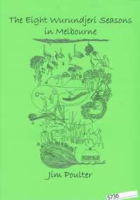
Booklet, Jim Poulter, The Eight Wurundjeri seasons in Melbourne, by Jim Poulter, 2015_
... Greensborough Historical Society 34A Glenauburn Road Lower Plenty Lower Plenty melbourne Description of the seasons occurring in Melbourne and their effect on Aboriginal culture and land management. aborigines aborigines victoria melbourne 15 p., booklet, illus. The Eight Wurundjeri seasons in Melbourne, by Jim Poulter Booklet Jim Poulter Red Hen Enterprises ...Description of the seasons occurring in Melbourne and their effect on Aboriginal culture and land management.15 p., booklet, illus.aborigines, aborigines victoria, melbourne -
 Mission to Seafarers Victoria
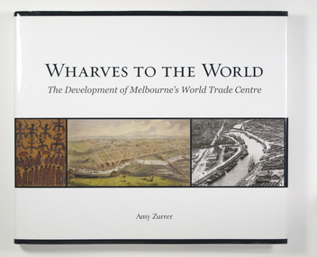
Book - Reference book, Melbourne Books, Wharves To The World: The Development Of Melbourne's World Trade Centre, 2011
... Construction of the retail precinct, WTC Wharf, was completed in late 2010. yarra yarra tribe early melbourne world trade centre melbourne southbank northbank australian wharf siddeley street waterfront amy zurrer wurundjeri spencer street bridge north wharf riverlee wtc wharf harbor trust sir john coode harbour trust little dock polly woodside wharfies divers Wharves to the World: The Development of Melbourne's World Trade Centre is a photographic chronicle of the history of the World Trade Centre and its surrounds. The book traces the journey of land ...Wharves to the World: The Development of Melbourne's World Trade Centre is a photographic chronicle of the history of the World Trade Centre and its surrounds. The book traces the journey of land and the buildings that occupied it - from its beginnings with the Wurundjeri people to its role as a trading hub in early Melbourne, then as the site of the modern-day World Trade Centre, and now as part of a flourishing residential and commercial Precinct. As with any major project The World Trade Centre has face its share of fêlures, but despite thèse it has become an integral part of the City. So it goes that was once home to swampland and the City morgue has been transformer into a Diamond of the Yarra River.A 128-page book of printed matter, photographs, engravings and drawings. The hard cover is white with the title in gold lettering on the front. The dust-cover is also white with black lettering. Along the lower half of the cover, front and back, is a strip of six photos, three coloured and three black and white. 128 p. : ill. (some col.), ports. non-fictionWharves to the World: The Development of Melbourne's World Trade Centre is a photographic chronicle of the history of the World Trade Centre and its surrounds. The book traces the journey of land and the buildings that occupied it - from its beginnings with the Wurundjeri people to its role as a trading hub in early Melbourne, then as the site of the modern-day World Trade Centre, and now as part of a flourishing residential and commercial Precinct. As with any major project The World Trade Centre has face its share of fêlures, but despite thèse it has become an integral part of the City. So it goes that was once home to swampland and the City morgue has been transformer into a Diamond of the Yarra River.yarra yarra tribe, early melbourne, world trade centre, melbourne, southbank, northbank, australian wharf, siddeley street, waterfront, amy zurrer, wurundjeri, spencer street bridge, north wharf, riverlee, wtc, wharf, harbor trust, sir john coode, harbour trust, little dock, polly woodside, wharfies, divers -
 Eltham District Historical Society Inc
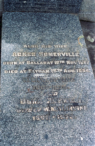
Negative - Photograph, Harry Gilham, Grave of William Hill and Agnes Somerville Irvine and family, Eltham Cemetery, Victoria, 1 Aug 2007
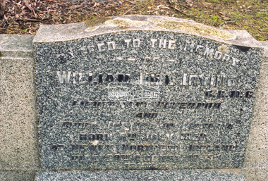
... land in Laughing Waters Road at Eltham, where he built the house ‘Killeavey’, initially as a weekend retreat. The site, a peninsula surrounded on three sides by the Yarra River, is of geological importance and has considerable cultural significance to the Wurundjeri. ...land in Laughing Waters Road at Eltham, where he built the house ‘Killeavey’, initially as a weekend retreat. The site, a peninsula surrounded on three sides by the Yarra River, is of geological importance and has considerable cultural significance to the Wurundjeri. ...William Hill Irvine was born 6 July, 1858 in Newry, County Down, Ireland. He arrived in Melbourne December 1879 and taught at Geelong College. He was admitted to the Supreme Court in 1884 having qualified from Melbourne University and practiced in Melbourne. In 1891 he married Agnes Somerville Wanliss and they had one son, William Mitchell (1901 Armadale) and two daughters, Beatrice Wanliss (1899 Armadale) and Agnes Somerville Wanliss (1903 Armadale). Sir William Irvine sat in the Victorian Parliament (as Liberal Member for Lowan) from 1894 to 1906 and was Premier of Victoria from 1902 to 1904. He then switched to Federal politics and sat in the Commonwealth Parliament (as Liberal Member for Flinders) from 1906 to 1918. He was considered a potential Prime Minister, but his abrupt manner and hard-line conservatism (particularly his attitude to a railway strike) made him unacceptable even to many Liberals: he was known in Parliament as "Iceberg Irvine". He lived at Richmond, but in 1908 purchased land in Laughing Waters Road at Eltham, where he built the house ‘Killeavey’, initially as a weekend retreat. The site, a peninsula surrounded on three sides by the Yarra River, is of geological importance and has considerable cultural significance to the Wurundjeri. In 1912 Sir William moved to Killeavey and in 1913 purchased more land, extending his property to Reynolds Road. In 1923 he shifted to Toorak, donating Killeavey to his daughter Beatrice as a wedding gift. Sir William was a founding member of the RACV and was Acting Governor of Victoria from 1931 to 1934. He was also a notable public figure involved in several local events including the: 1919 Unveiling of Eltham War Obelisk 1921 Eltham Primary School Extensions 1921 Eltham Primary School Roll of Honour of prior students 1928 Opening of Eltham Higher Elementary School 1926 Unveiling the Shire of Eltham War Memorial in Memorial Park at Kangaroo Ground He died in 1943 and is buried in Eltham Cemetery with his wife Agnes along with son William Mitchell Irvine and his wife, Dora Haswell Sacred to the memory of William Hill Irvine G.C.M.G. Lieutenant Governor And Chief Justice of Victoria Born 6th July 1858 At Newry, Northern Ireland Died 20th August 1943 Also his wife Agnes Somerville Born at Ballarat 16th Nov 1867 Died at Eltham 16th Aug 1954 W. M. W. Irvine 1901-1975 And Dora Haswell Wife of W. M. W. Irvine 1900-1979eltham cemetery, gravestones, memorials, agnes sommerville irvine (nee wanliss), dora haswell irvine, william hill irvine, william mitchell irvine -
 Eltham District Historical Society Inc
Negative - Photograph, Harry Gilham, Grave of William Hill and Agnes Somerville Irvine and family, Eltham Cemetery, Victoria, 1 Aug 2007
... land in Laughing Waters Road at Eltham, where he built the house ‘Killeavey’, initially as a weekend retreat. The site, a peninsula surrounded on three sides by the Yarra River, is of geological importance and has considerable cultural significance to the Wurundjeri. ...land in Laughing Waters Road at Eltham, where he built the house ‘Killeavey’, initially as a weekend retreat. The site, a peninsula surrounded on three sides by the Yarra River, is of geological importance and has considerable cultural significance to the Wurundjeri. ...William Hill Irvine was born 6 July, 1858 in Newry, County Down, Ireland. He arrived in Melbourne December 1879 and taught at Geelong College. He was admitted to the Supreme Court in 1884 having qualified from Melbourne University and practiced in Melbourne. In 1891 he married Agnes Somerville Wanliss and they had one son, William Mitchell (1901 Armadale) and two daughters, Beatrice Wanliss (1899 Armadale) and Agnes Somerville Wanliss (1903 Armadale). Sir William Irvine sat in the Victorian Parliament (as Liberal Member for Lowan) from 1894 to 1906 and was Premier of Victoria from 1902 to 1904. He then switched to Federal politics and sat in the Commonwealth Parliament (as Liberal Member for Flinders) from 1906 to 1918. He was considered a potential Prime Minister, but his abrupt manner and hard-line conservatism (particularly his attitude to a railway strike) made him unacceptable even to many Liberals: he was known in Parliament as "Iceberg Irvine". He lived at Richmond, but in 1908 purchased land in Laughing Waters Road at Eltham, where he built the house ‘Killeavey’, initially as a weekend retreat. The site, a peninsula surrounded on three sides by the Yarra River, is of geological importance and has considerable cultural significance to the Wurundjeri. In 1912 Sir William moved to Killeavey and in 1913 purchased more land, extending his property to Reynolds Road. In 1923 he shifted to Toorak, donating Killeavey to his daughter Beatrice as a wedding gift. Sir William was a founding member of the RACV and was Acting Governor of Victoria from 1931 to 1934. He was also a notable public figure involved in several local events including the: 1919 Unveiling of Eltham War Obelisk 1921 Eltham Primary School Extensions 1921 Eltham Primary School Roll of Honour of prior students 1928 Opening of Eltham Higher Elementary School 1926 Unveiling the Shire of Eltham War Memorial in Memorial Park at Kangaroo Ground He died in 1943 and is buried in Eltham Cemetery with his wife Agnes along with son William Mitchell Irvine and his wife, Dora Haswell Sacred to the memory of William Hill Irvine G.C.M.G. Lieutenant Governor And Chief Justice of Victoria Born 6th July 1858 At Newry, Northern Ireland Died 20th August 1943 Also his wife Agnes Somerville Born at Ballarat 16th Nov 1867 Died at Eltham 16th Aug 1954 W. M. W. Irvine 1901-1975 And Dora Haswell Wife of W. M. W. Irvine 1900-1979eltham cemetery, gravestones, memorials, agnes sommerville irvine (nee wanliss), dora haswell irvine, william hill irvine, william mitchell irvine -
 Eltham District Historical Society Inc
Photograph - Black and White Print, Moor-rul Viewing Platform, March 2007
... This landscape covers all the ancestral lands of the Wurundjeri and some of the wider Kulin nation land. The platform has been given the name Moor-rut, a name which described the fertile soils of the Kangaroo Ground area in contrast to the poorer (Silurian) country of its surrounds, which the Wurundjeri knew as 'Nillumbik' or less rich country. ...This landscape covers all the ancestral lands of the Wurundjeri and some of the wider Kulin nation land. The platform has been given the name Moor-rut, a name which described the fertile soils of the Kangaroo Ground area in contrast to the poorer (Silurian) country of its surrounds, which the Wurundjeri knew as 'Nillumbik' or less rich country. ...Early stages - no display panels installed. OPENING OF THE VIEWING PLATFORM AT KANGAROO GROUND Nillumbik Council has advised that the viewing platform at Kangaroo Ground 27km NE of Melbourne is to be opened to the public on Wednesday, March 26th 2008 (Melway 271 , G10). The function of the platform is to provide shelter adjacent to the War Memorial Tower whilst allowing all people to enjoy the stunning panoramic views. From the platform you. can see the Dandenongs, the city of Melbourne, the You Yangs, Mount Macedon, the Kinglake Ranges and the Mt Baw-Baw Ranges where the Yarra River starts. This landscape covers all the ancestral lands of the Wurundjeri and some of the wider Kulin nation land. The platform has been given the name Moor-rut, a name which described the fertile soils of the Kangaroo Ground area in contrast to the poorer (Silurian) country of its surrounds, which the Wurundjeri knew as 'Nillumbik' or less rich country. The full 360 degree view can be seen from the adjacent Tower of Remembrance which has 53 stairs. The viewing platform however can be accessed by wheelchair. Inside the viewing platform there are eight double sided interpretive panels giving the history and information regarding this special area. The viewing platform's interpretive panels set out the Aboriginal and European history of the area and also the geology and the local flora and fauna, so that the casual visitor comes away understanding more about this significant part of Victoria. The concept of the viewing platform is part of the refurbishment project for the Kangaroo Ground War Memorial Park which has taken place since 1997 with the active approval and financial assistance of the Nillumbik Shire Council. This project has been guided by an Advisory Committee with volunteer community representatives from the local Historical Societies, the Country Fire Authority, the Returned Services League and the Wurundjeri people. Other allied groups such as the Nillumbik Reconciliation Group have been called upon for their expertise. The initial idea for the viewing platform came from Dean Stewart when he was the caretaker while living at the park. He discussed this idea with local author Mick Woiwod and Harry Gilham of Eltham District Historical Society when they were planning the refurbishment of the War Memorial Park in 1996. When the committee was formalised by the Nillumbik Council in 1997, Nicholas Pelling, representing the CFA and RSL, joined the group. Dennis Ward, local architect, then volunteered to develop the concept plan for the refurbishment of the park and later drew up the plans for the viewing platform. The Kangaroo Ground War Memorial Park and its Tower of Remembrance is located on one of the highest locations in the Yarra Valley. The Tower of Remembrance is a unique war memorial constructed from local stone standing 14 metres high. It was built in the style of a Scottish watchtower reflecting the strong Scottish influence of the first European settlers of the district from the 1840s onward. The park was opened in 1921 and the Tower of Remembrance was dedicated in 1926 recognising the local people who served in the First World War. Those who served in the Second World War were recognised by plaques dedicated in 1951 and more recently those who served in Korea, Borneo, Malaya and Vietnam by plaques unveiled in 2001. Harry Gilham, Advisory Committee Convenor - Eltham District Historical Society Newsletter N0 179 March 2008 Black and white inkjet print on paper 14 x 21 cmmoor-rul viewing platform, garden hill, kangaroo ground, memorial park -
 Eltham District Historical Society Inc
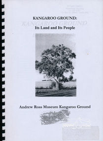
Book, Andrew Ross Museum, Kangaroo Ground: its Land and its People by Mick Woiwod published by Andrew Ross Museum, 2002
... Eltham District Historical Society Inc 728 Main Rd Eltham melbourne Kangaroo Ground's geology, original people, European settlers, plants used by Wurundjeri people wurundjeri (australian people) 26 leaves : ill., maps ; 30 cm. Kangaroo Ground: its Land and its People by Mick Woiwod published by Andrew Ross Museum Book Andrew Ross Museum Mick Woiwod ...Kangaroo Ground's geology, original people, European settlers, plants used by Wurundjeri people26 leaves : ill., maps ; 30 cm.wurundjeri (australian people)