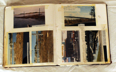
Showing 197 items matching "1934 floods"
-
 Kew Historical Society Inc
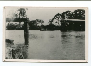
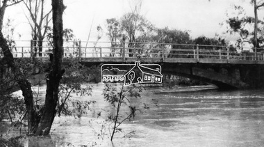
Photograph - Kane's Bridge destroyed by the 1934 Flood, 1934
... Kane's Bridge destroyed by the 1934 Flood......1934 floods...The total cost of construction came to 250 pounds and the bridge became known as Kane's Bridge. During the 1934 floods the bridge was washed downstream, and was subsequently rebuilt. ...Black and white positive print (identical to 2021.70 but with a different annotation) showing the destruction of Kane's Bridge in the floods of 1934. The Kodak paper would indicate a 1950s reprinting....Annotation verso: "Kane's Bridge in 1934 flood / Dec. 1934....(VHD) kane's bridge River Yarra Yarra valley 1934 floods Annotation verso: "Kane's Bridge in 1934 flood / Dec. 1934. ...In 1928 a footbridge was erected to link Kew with the public golf course across the Yarra. The total cost of construction came to 250 pounds and the bridge became known as Kane's Bridge. During the 1934 floods the bridge was washed downstream, and was subsequently rebuilt. The present form of the bridge resembles the earlier bridge which crossed from the Yarra Bend Asylum to Kew, further upstream. (VHD)Black and white positive print (identical to 2021.70 but with a different annotation) showing the destruction of Kane's Bridge in the floods of 1934. The Kodak paper would indicate a 1950s reprinting.Annotation verso: "Kane's Bridge in 1934 flood / Dec. 1934.kane's bridge, river yarra, yarra valley, 1934 floods -
 Clunes Museum
Photograph, FLOODS 1934
... FLOODS 1934......FLOODS 1934...BLACK AND WHITE SMALL PHOTOGRAPH OF CLUNES FLOODS IN 1934. CLUNES QUEEN'S PARK WITH FOUNTAIN UNDER WATER - TREES IN THE BACKGROUND AND A FEW FLOWERS IN THE FOREGROUND....Clunes Museum 36 Fraser Street enter building through Collins Place Clunes goldfields AFTER HEAVY RAINS - CRESWICK CREEK IN CLUNES TOWNSHIP FLOODED, OVER FLOWING ITS BANKS, NEAR BY AREAS WERE SUBMERGED. local history queen's park garden. FLOODS 1934 BLACK AND WHITE SMALL PHOTOGRAPH OF CLUNES FLOODS IN 1934. ...AFTER HEAVY RAINS - CRESWICK CREEK IN CLUNES TOWNSHIP FLOODED, OVER FLOWING ITS BANKS, NEAR BY AREAS WERE SUBMERGED.BLACK AND WHITE SMALL PHOTOGRAPH OF CLUNES FLOODS IN 1934. CLUNES QUEEN'S PARK WITH FOUNTAIN UNDER WATER - TREES IN THE BACKGROUND AND A FEW FLOWERS IN THE FOREGROUND.local history, queen's park garden., floods 1934 -
 Eltham District Historical Society Inc
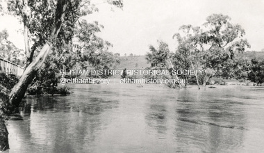
Photograph, 1934 Floods at Eltham
... 1934 Floods at Eltham...The large leaning Manna Gum beside the bridge still stands in 2021 alongside the Diamond Creek trail. In 1934 extensive flooding of the Yarra River and Diamond Creek set new records for flood plain level (Eltham Chronology, EDHS)...Copied by Hugh Fisher, Photographer, 6 York Street Eltham A1678B Floods- Eltham - 1934...The large leaning Manna Gum beside the bridge still stands in 2021 alongside the Diamond Creek trail. In 1934 extensive flooding of the Yarra River and Diamond Creek set new records for flood plain level (Eltham Chronology, EDHS) floods yarra river eltham flooding diamond creek flood Copied by Hugh Fisher, Photographer, 6 York Street Eltham A1678B Floods- Eltham - 1934 Black and white photograph 1934 Floods at Eltham Photograph Photograph ...Published in the Diamond Creek Basin Study, 1980 and identified at Diamond Creek, locality not identified, 1934. The location is actually looking south across the Diamond Creek towards Falkiner Street, beside the Main Road bridge at Eltham South from what is now part of Wingrove Park opposite Antoinette Boulevard. The bridge railing is just visible to the left of image. The large leaning Manna Gum beside the bridge still stands in 2021 alongside the Diamond Creek trail. In 1934 extensive flooding of the Yarra River and Diamond Creek set new records for flood plain level (Eltham Chronology, EDHS)Black and white photographCopied by Hugh Fisher, Photographer, 6 York Street Eltham A1678B Floods- Eltham - 1934floods, yarra river, eltham, flooding, diamond creek, flood -
 Kew Historical Society Inc
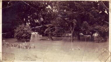
Photograph, Willsmere Bridge, 1934
... Following the 1934 flood, the house was restored. The floating pontoon, sometimes referred to as a ‘kiosk’ or ‘canteen’, was used to store canoes. ...A view of flooded areas in North Kew in the flood of 1934....Chipperfields. 1934 flood...Chipperfields. 1934 flood A view of flooded areas in North Kew in the flood of 1934. ...Several boathouses were built in Kew and Fairfield in the late 19th and early 20th centuries. They included Chipperfield’s ‘Moorings’ and floating pontoon. The substantial two-storey house was named the Moorings, and incorporated an upper storey residence. The Moorings was almost washed away in the 1916 floods, and in 1934 almost totally submerged when the Yarra River rose 26 feet in 14 hours. Following the 1934 flood, the house was restored. The floating pontoon, sometimes referred to as a ‘kiosk’ or ‘canteen’, was used to store canoes. Both were removed in 1972 for the construction of the Eastern Freeway.This work forms part of the collection assembled by the historian Dorothy Rogers, that was donated to the Kew Historical Society by her son John Rogers in 2015. The manuscripts, photographs, maps, and documents were sourced by her from both family and local collections or produced as references for her print publications. Many were directly used by Rogers in writing ‘Lovely Old Homes of Kew’ (1961) and 'A History of Kew' (1973), or the numerous articles on local history that she produced for suburban newspapers. Most of the photographs in the collection include detailed annotations in her hand. The Rogers Collection provides a comprehensive insight into the working habits of a historian in the 1960s and 1970s. Together it forms the largest privately-donated collection within the archives of the Kew Historical Society.A view of flooded areas in North Kew in the flood of 1934.Willsmere Bridge. Chipperfields. 1934 floodwillsmere, flood, yarra flood, chipperfields, chipperfields boathouse, north kew -
 Kew Historical Society Inc
Photograph, Yarra at Fairfield, 1934 Floods, 1934
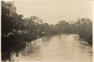
... Yarra at Fairfield, 1934 Floods...floods - kew - 1934...Yarra at Fairfield, 1934 Floods Photograph Photograph ...One of three digital copies of flooded areas of Kew (1923-34), donated by Jan Coutts of Bulleen in 2019. The handwriting on the originals predates the copy.1934 YARRA FAIRFIELD FROM OPPOSITE RUDDER GRANGE floods - kew - 1934 -
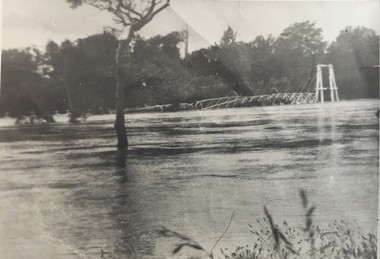
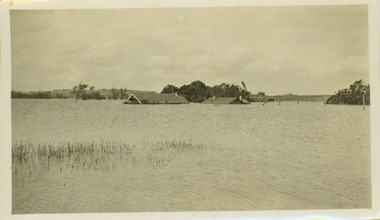
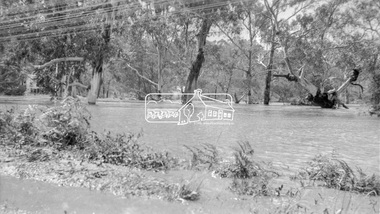
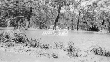
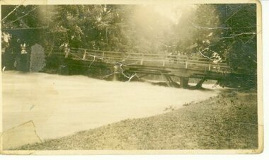
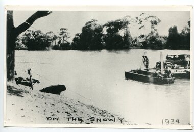
 Orbost & District Historical Society
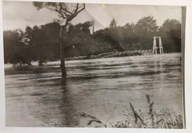
Photograph - Snowy River Bridge, 1934, 1934
... ...1934 flood...The photo destruction of the mid-section of the bridge by the 1934 flood. This was a major flood. This photo has been used for display purposes....On back: 1934 flood....This photo is significant because is shows the destruction caused by a major flood in the Snowy River in 1934. Snowy River Snowy River bridge Orbost 1934 flood On back: 1934 flood. ...This is a photograph taken of the Snowy River Bridge at Orbost in 1934. The photo destruction of the mid-section of the bridge by the 1934 flood. This was a major flood. This photo has been used for display purposes.This photo is significant because is shows the destruction caused by a major flood in the Snowy River in 1934.A b/w photo showing a large timber bridge with a section in the middle missing. The bridge has white railings. In the background appear to be a barge. There is also a small rowboat in the front left of the photo. On back: 1934 flood.snowy river, snowy river bridge, orbost, 1934 flood -
 Kew Historical Society Inc
Photograph - Kane's Bridge on the Yarra River, December 1934
... ...1934 floods...The total cost of construction came to 250 pounds and the bridge became known as Kane's Bridge. During the 1934 floods the bridge was washed downstream, and was subsequently rebuilt. ...Original, black and white positive of Kane's Bridge in December 1934, when the 'great flood' of the Yarra caused the bridge's destruction. ...Inscribed verso: "Kane's Bridge Yarra in flood Dec 1934"...(VHD) river yarra yarra -- kew (vic.) Kanes bridge 1934 floods Inscribed verso: "Kane's Bridge Yarra in flood Dec 1934" Original, black and white positive of Kane's Bridge in December 1934, when the 'great flood' of the Yarra caused the bridge's destruction. ...In 1928 a footbridge was erected to link Kew with the public golf course across the Yarra. The total cost of construction came to 250 pounds and the bridge became known as Kane's Bridge. During the 1934 floods the bridge was washed downstream, and was subsequently rebuilt. The present form of the bridge resembles the earlier bridge which crossed from the Yarra Bend Asylum to Kew, further upstream. (VHD)Original, black and white positive of Kane's Bridge in December 1934, when the 'great flood' of the Yarra caused the bridge's destruction. Inscribed verso: "Kane's Bridge Yarra in flood Dec 1934"river yarra, yarra -- kew (vic.), kanes bridge, 1934 floods -
 Kew Historical Society Inc
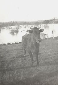
Photograph, Cattle in North Kew floods, 1934
... floods (melbourne) 1934...The year 1934 witnessed the greatest flooding of the Yarra River since settlement. ...Photograph of floodwaters encroaching on farm land in North Kew in the flood of 1934....Nth. Kew. 1934 Floods...Together it forms the largest privately-donated collection within the archives of the Kew Historical Society. floods (melbourne) 1934 dorothy rogers Nth. Kew. 1934 Floods Photograph of floodwaters encroaching on farm land in North Kew in the flood of 1934. ...The year 1934 witnessed the greatest flooding of the Yarra River since settlement. This work forms part of the collection assembled by the historian Dorothy Rogers, that was donated to the Kew Historical Society by her son John Rogers in 2015. The manuscripts, photographs, maps, and documents were sourced by her from both family and local collections or produced as references for her print publications. Many were directly used by Rogers in writing ‘Lovely Old Homes of Kew’ (1961) and 'A History of Kew' (1973), or the numerous articles on local history that she produced for suburban newspapers. Most of the photographs in the collection include detailed annotations in her hand. The Rogers Collection provides a comprehensive insight into the working habits of a historian in the 1960s and 1970s. Together it forms the largest privately-donated collection within the archives of the Kew Historical Society.Photograph of floodwaters encroaching on farm land in North Kew in the flood of 1934.Nth. Kew. 1934 Floodsfloods (melbourne) 1934, dorothy rogers -
 Kew Historical Society Inc
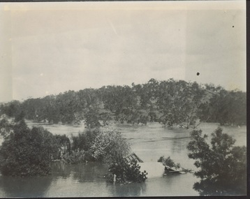
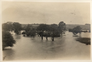
Photograph - Yarra in Flood, 1934
... floods -- 1934...Extreme flood events of the Yarra River are recorded to have occurred in 1891, 1901, 1916, 1923 and 1934. ...Black and white print positive. 1934 floods of the Yarra Valley. Location Fairfield looking towards wooded hillside. ...Black and white print positive. 1934 floods of the Yarra Valley. Location Fairfield looking towards wooded hillside. ...Flooding of the Yarra Valley, including that section of the Yarra bordering Kew and Kew East in the north and west of the municipality, was a regular occurrence. Extreme flood events of the Yarra River are recorded to have occurred in 1891, 1901, 1916, 1923 and 1934. The Municipality of Kew's response to these floods was to enact planning decisions restricting residential development in flood prone areas following the floods of 1916, 1921 and 1934. While floods continued after the development of the Upper Yarra Reservoir (construction 1948-57), the regularity and extent of these inundations diminished.Black and white print positive. 1934 floods of the Yarra Valley. Location Fairfield looking towards wooded hillside. Houses floating in river.Reverse: "From Fairfield Park (11936?) back towards hill (Wurundjeri Spur?)"floods -- 1934, yarra valley, yarra river, fairfield park -
 Orbost & District Historical Society
black and white photograph, January 1934
... orbost-floods-1934 natural-disasters-floods snowy-river-bridge...Damage estimated at £500,000 was caused by the 1934 floods in the Orbost district. This 1934 flood was devastating, destroying a section of the 1922 Orbost bridge, wrecking fences, bridges and roads, dumping silt and debris on the rich river flats and drowning cattle. ...This item is a pictorial record of the 1934 floods, a significant part of Orbost's history. orbost-floods-1934 natural-disasters-floods snowy-river-bridge A black / white photograph showing the flood damage to the Snowy River Bridge. ...Damage estimated at £500,000 was caused by the 1934 floods in the Orbost district. This 1934 flood was devastating, destroying a section of the 1922 Orbost bridge, wrecking fences, bridges and roads, dumping silt and debris on the rich river flats and drowning cattle. The centre span of the Orbost Bridge was washed away. This item is a pictorial record of the 1934 floods, a significant part of Orbost's history.A black / white photograph showing the flood damage to the Snowy River Bridge. There is a gap in the bridge where the centre span has been washed away. In the background is a punt.orbost-floods-1934 natural-disasters-floods snowy-river-bridge -
 Eltham District Historical Society Inc
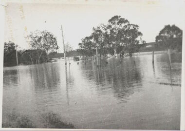
Photograph, Eltham - Floods in 1934
... Eltham - Floods in 1934......1934 Flood...The Yarra also was in flood. In early December 1934 the "Greatest flood in the history of the Yarra" occured, according to The Argus newspaper. ...The Yarra also was in flood. In early December 1934 the "Greatest flood in the history of the Yarra" occured, according to The Argus newspaper. ...To the left of picture is the Main Road Bridge over the Diamond Creek in Eltham South when the Diamond Creek was in flood. The Yarra also was in flood. In early December 1934 the "Greatest flood in the history of the Yarra" occured, according to The Argus newspaper. Bridges and houses were swept away with hundreds of people left homeless across the state. The historic 1934 flood of the Diamond Creek and Yarra River set the criteria for future planning with respect to flood water rise.This photo forms part of a collection of photographs gathered by the Shire of Eltham for their centenary project book, "Pioneers and Painters: 100 years of the Shire of Eltham" by Alan Marshall (1971). The collection of over 500 images is held in partnership between Eltham District Historical Society and Yarra Plenty Regional Library (Eltham Library) and is now formally known as 'The Shire of Eltham Pioneers Photograph Collection.' It is significant in being the first community sourced collection representing the places and people of the Shire's first one hundred years.Digital image 4 x 5 inch B&W Negsepp, shire of eltham pioneers photograph collection, eltham, diamond creek (river), 1934 flood, diamond creek, floods, main road bridge -
 Orbost & District Historical Society
black / white photograph, January 1934
... orbost-floods-1934 natural-disasters-floods...Damage estimated at £500,000 was caused by the 1934 floods in the Orbost district. This 1934 flood was devastating, destroying a section of the 1922 Orbost bridge, wrecking fences, bridges and roads, dumping silt and debris on the rich river flats and drowning cattle. ...This item is a pictorial record of the 1934 floods, a significant part of Orbost's history. orbost-floods-1934 natural-disasters-floods A black / white photograph of swirling floodwaters with township in the background. black / white photograph ...Damage estimated at £500,000 was caused by the 1934 floods in the Orbost district. This 1934 flood was devastating, destroying a section of the 1922 Orbost bridge, wrecking fences, bridges and roads, dumping silt and debris on the rich river flats and drowning cattle. This photograph shows Lochiel Lagoon ( the billabong) in the foreground. Ten minutes after this photograph was taken, the centre span of the Orbost Bridge was washed away.This item is a pictorial record of the 1934 floods, a significant part of Orbost's history.A black / white photograph of swirling floodwaters with township in the background.orbost-floods-1934 natural-disasters-floods -
 Kew Historical Society Inc
Photograph - Flood at Fairfield Park, 1934
... ...floods -- 1934...Extreme flood events of the Yarra River are recorded to have occurred in 1891, 1901, 1916, 1923 and 1934. ...Yarra River at Fairfield in 1934. Major flood resulting in submerged buildings in middle ground and onlookers on far bank...Reverse: "Flood of Yarra at Fairfield Park 1934"...Fairfield park yarra valley river yarra floods -- 1934 Reverse: "Flood of Yarra at Fairfield Park 1934" Black and white print positive. ...Flooding of the Yarra Valley, including that section of the Yarra bordering Kew and Kew East in the north and west of the municipality, was a regular occurrence. Extreme flood events of the Yarra River are recorded to have occurred in 1891, 1901, 1916, 1923 and 1934. The Municipality of Kew's response to these floods was to enact planning decisions restricting residential development in flood prone areas following the floods of 1916, 1921 and 1934. While floods continued after the development of the Upper Yarra Reservoir (construction 1948-57), the regularity and extent of these inundations diminished.Black and white print positive. Yarra River at Fairfield in 1934. Major flood resulting in submerged buildings in middle ground and onlookers on far bankReverse: "Flood of Yarra at Fairfield Park 1934"fairfield park, yarra valley, river yarra, floods -- 1934 -
 Kew Historical Society Inc
Photograph - Submerged houses in River Avenue, North Kew, 1934
... ...floods -- 1934...Small sepia snapshot of two submerged houses belonging to local families in River Avenue, North Kew, during the 1934 floods. The view is presumably from near Kellett Grove looking north towards Fairfield....Vivid photograph contrasting domestic life and relationships with natural disasters such as the flood of 1934. yarra river -- north kew floods -- yarra valley floods -- north kew floods -- 1934 natural disasters -- kew Verso: COES & HYATTS ROOF / RIVER AVENUE / Stamped: 6414 Small sepia snapshot of two submerged houses belonging to local families in River Avenue, North Kew, during the 1934 floods. ...North Kew, now divided between Kew and Kew East, bordered the Yarra River. As such, it was a region subject to flooding in the Yarra Valley. Development beyond this point (ie Kellett Grove) was limited by the City of Kew's planning regulations. Prior to urban development, the area since European settlement and the first land sales in the district in the 1840s, had been used for dairy farming. Vivid photograph contrasting domestic life and relationships with natural disasters such as the flood of 1934.Small sepia snapshot of two submerged houses belonging to local families in River Avenue, North Kew, during the 1934 floods. The view is presumably from near Kellett Grove looking north towards Fairfield.Verso: COES & HYATTS ROOF / RIVER AVENUE / Stamped: 6414yarra river -- north kew, floods -- yarra valley, floods -- north kew, floods -- 1934, natural disasters -- kew -
 Eltham District Historical Society Inc
Negative - Photograph, Diamond Creek floodwater at Monash Bridge, Hurstbridge, Dec. 1934
... ...1934 flood...The historic 1934 flood of the Diamond Creek and Yarra River following the storms of 29-30 November set the levels for future planning with respect to flood water rise....It is significant in being the first community sourced collection representing the places and people of the Shire's first one hundred years. shire of eltham pioneers photograph collection hurstbridge 1934 flood floods monash bridge diamond creek (creek) Digital image 4 x 5 inch B&W Neg Diamond Creek floodwater at Monash Bridge, Hurstbridge Negative Photograph ...The historic 1934 flood of the Diamond Creek and Yarra River following the storms of 29-30 November set the levels for future planning with respect to flood water rise.This photo forms part of a collection of photographs gathered by the Shire of Eltham for their centenary project book,"Pioneers and Painters: 100 years of the Shire of Eltham" by Alan Marshall (1971). The collection of over 500 images is held in partnership between Eltham District Historical Society and Yarra Plenty Regional Library (Eltham Library) and is now formally known as the 'The Shire of Eltham Pioneers Photograph Collection.' It is significant in being the first community sourced collection representing the places and people of the Shire's first one hundred years.Digital image 4 x 5 inch B&W Negshire of eltham pioneers photograph collection, hurstbridge, 1934 flood, floods, monash bridge, diamond creek (creek) -
 Kew Historical Society Inc
Photograph, Floods in North Kew, 1934
... floods (kew) 1934...The great flood of 1934 in Melbourne was one of the most devastating floods since records began. ...Floods in North Kew, 1934. Flood near Lagoon (Billabong?) Willsmere Road, North Kew....Locally significant photographs of the impact of flooding in Kew in 1934 floods (kew) 1934 yarra river Floods in North Kew, 1934. ...The great flood of 1934 in Melbourne was one of the most devastating floods since records began. The floods affected all of Melbourne, including Kew.Locally significant photographs of the impact of flooding in Kew in 1934Floods in North Kew, 1934. Flood near Lagoon (Billabong?) Willsmere Road, North Kew.floods (kew) 1934, yarra river -
 Orbost & District Historical Society
collection of newspaper articles, 1917, 1929, 1934
... Orbost-floods-1934 WW1-photgraphs-Orbost-Weekly-Times...A cardboard folder of black and white newspaper cuttings relating to the 1934 floods in Orbost, war photographs and local events and residents. 747.1 is from the February 3, 1934 Weekly Times and is titled, " FLOOD PHOTOS ORBOST". 747.2 is from the Weekly Times, 9 June 1917 and contains war photos and photographs of Orbost - 11 May, 1929....These articles are contemporary records of significant events in the history of Orbost and as such are useful reference tools. Orbost-floods-1934 WW1-photgraphs-Orbost-Weekly-Times A cardboard folder of black and white newspaper cuttings relating to the 1934 floods in Orbost, war photographs and local events and residents. 747.1 is from the February 3, 1934 Weekly Times and is titled, " FLOOD PHOTOS ORBOST". 747.2 is from the Weekly Times, 9 June 1917 and contains war photos and photographs of Orbost - 11 May, 1929. collection of newspaper articles Herald and Weekly Times ...These articles were collated by Mary Gilbert. Mary Isabelle Gilbert was born in 1905 in Orbost, Australia. She was born to John Gilbert and Annie Cameron Gilbert. She was a teacher historian loved and respected by her family and the wider community.These articles are contemporary records of significant events in the history of Orbost and as such are useful reference tools.A cardboard folder of black and white newspaper cuttings relating to the 1934 floods in Orbost, war photographs and local events and residents. 747.1 is from the February 3, 1934 Weekly Times and is titled, " FLOOD PHOTOS ORBOST". 747.2 is from the Weekly Times, 9 June 1917 and contains war photos and photographs of Orbost - 11 May, 1929.orbost-floods-1934 ww1-photgraphs-orbost-weekly-times -
 Orbost & District Historical Society
album, Our Natural Disasters Hailstorm 1991 Floods 1934-1998, between 1998 and 2003?
... Our Natural Disasters Hailstorm 1991 Floods 1934-1998...Our Natural Disasters Hailstorm 1991 Floods 1934-1998 album Orbost Visitor Information Centre ...This album was compiled for the use of visitors to the Slab Hut (Orbost Visitor Information Centre).This album is a useful research tool.A photo album with a maroon cover with gold embossing. On the cover is the title Our Natural Disasters. It contains 54 pages of photos of local natural disasters - flood, fire and hail. The photos are taped in.slab-hut orbost-disasters album orbost-floods-fires-hailstorms -
 Eltham District Historical Society Inc
Photograph, Floodwaters, Diamond Creek, Eltham, 1934
... ...floods...1934...The Yarra also was in flood. In early December 1934 the "Greatest flood in the history of the Yarra" occured, according to The Argus newspaper. ...The Yarra also was in flood. In early December 1934 the "Greatest flood in the history of the Yarra" occured, according to The Argus newspaper. ...The Diamond Creek in flood near the Main Road bridge at Eltham, Victoria. The Yarra also was in flood. In early December 1934 the "Greatest flood in the history of the Yarra" occured, according to The Argus newspaper. Bridges and houses were swept away with hundreds of people left homeless across the state. The historic 1934 flood of the Diamond Creek and Yarra River set the criteria for future planning with respect to flood water rise.This photo forms part of a collection of photographs gathered by the Shire of Eltham for their centenary project book, "Pioneers and Painters: 100 years of the Shire of Eltham" by Alan Marshall (1971). The collection of over 500 images is held in partnership between Eltham District Historical Society and Yarra Plenty Regional Library (Eltham Library) and is now formally known as 'The Shire of Eltham Pioneers Photograph Collection.' It is significant in being the first community sourced collection representing the places and people of the Shire's first one hundred years.Digital image 4 x 5 inch B&W Neg (2 frames on one neg) 9 x 15.5 cm B&W printflooding, eltham, shire of eltham pioneers photograph collection, sepp, diamond creek (river), floods, 1934 flood, diamond creek -
 Eltham District Historical Society Inc
Negative - Photograph, Floodwaters, Diamond Creek, Eltham, 1934
... ...floods...1934...The Yarra also was in flood. In early December 1934 the "Greatest flood in the history of the Yarra" occured, according to The Argus newspaper. ...The Yarra also was in flood. In early December 1934 the "Greatest flood in the history of the Yarra" occured, according to The Argus newspaper. ...The Diamond Creek in flood near the Main Road bridge at Eltham, Victoria. The Yarra also was in flood. In early December 1934 the "Greatest flood in the history of the Yarra" occured, according to The Argus newspaper. Bridges and houses were swept away with hundreds of people left homeless across the state. The historic 1934 flood of the Diamond Creek and Yarra River set the criteria for future planning with respect to flood water rise. Noted on reverse of print - Copied by Hugh Fisher, 82 Lygon St., BrunswickThis photo forms part of a collection of photographs gathered by the Shire of Eltham for their centenary project book,"Pioneers and Painters: 100 years of the Shire of Eltham" by Alan Marshall (1971). The collection of over 500 images is held in partnership between Eltham District Historical Society and Yarra Plenty Regional Library (Eltham Library) and is now formally known as the 'The Shire of Eltham Pioneers Photograph Collection.' It is significant in being the first community sourced collection representing the places and people of the Shire's first one hundred years.Digital image 4 x 5 inch B&W Neg (2 frames on one neg) Print 9 x 15.5 cmOn reverse of print - "Copied by Hugh Fisher, 82 Lygon St., Brunswick" (for Shire of Eltham)sepp, shire of eltham pioneers photograph collection, eltham, floods, 1934 flood, diamond creek (creek), floodwater -
 Clunes Museum
Photograph, KODAK, CLUNES FLOOD 1934, 1934
... CLUNES FLOOD 1934...CRESWICK CREEK FLOODED IN 1934. AFTER VERY HEAVY RAINS UP STREAM - WATER REACHED SOLDIER'S MONUMENT AND PURCELL STREET CLUNES...BUTTER FACTORY BRIDGE WITH WATER THREE QUARTERS UP PYLONS. 1934 FLOODS TREES IN QUEEN'S PARK IN BACKGROUND....CLUNES FLOOD 1934 Photograph PHOTOGRAPH KODAK ...CRESWICK CREEK FLOODED IN 1934. AFTER VERY HEAVY RAINS UP STREAM - WATER REACHED SOLDIER'S MONUMENT AND PURCELL STREET CLUNESBLACK AND WHITE PHOTOGRAPH OF CRESWICK CREEK IN FLOOD. BUTTER FACTORY BRIDGE WITH WATER THREE QUARTERS UP PYLONS. 1934 FLOODS TREES IN QUEEN'S PARK IN BACKGROUND.clunes floods, photograph, creswick creek -
 Kew Historical Society Inc
Photograph, Floods in North Kew, 1934
... floods (kew) 1934...Newspapers continued to describe major flooding in Kew in 1863, 1869, 1878, 1880, 1889, 1891, 1916 and 1934. While the construction of the Upper Yarra dam in 1957 reduced the levels of flowing downstream, local and riverine floods continue....Floods in North Kew, 1934. Flood near the lagoon (Billabong?)...Numerous photographs record flooding throughout the Twentieth Century. floods (kew) 1934 yarra river Floods in North Kew, 1934. ...Living with natural processes was frequently a challenge to early European settlers and later residents of what was in the 1850s administered by the Borondara Road Board. This was compounded by the area being bounded on three sides by rivers (Yarra River, Koonung Creek and Gardiner's Creek). In 1849, the historian James Bonwick recorded that "our district [Kew] suffered considerably. Mr Wade speaks of 80 acres, out of 100 acres of his cultivated paddock, covered by water." Newspapers continued to describe major flooding in Kew in 1863, 1869, 1878, 1880, 1889, 1891, 1916 and 1934. While the construction of the Upper Yarra dam in 1957 reduced the levels of flowing downstream, local and riverine floods continue.The Kew Historical Society's pictures and map collections testify to the impact of flooding in the district. They have historical importance in documenting the extent of flooding in the district and its affects on homes, services and recreation. Numerous photographs record flooding throughout the Twentieth Century.Floods in North Kew, 1934. Flood near the lagoon (Billabong?)floods (kew) 1934, yarra river -
 University of Melbourne, Burnley Campus Archives
Document, Improvements (Completed files), 1925-1935
... Correspondence mainly re drainage, repairs after 1934 floods. etc....University of Melbourne, Burnley Campus Archives 500 Yarra Boulevard Richmond melbourne drainage repairs floods improvements Correspondence mainly re drainage, repairs after 1934 floods. etc. Improvements (Completed files) Document ...Correspondence mainly re drainage, repairs after 1934 floods. etc.drainage, repairs, floods, improvements -
Kew Historical Society Inc
Collection, Floods in North Kew (Series), 1929–1934
... ...Floods -- 1934...Extreme flood events of the Yarra River are recorded to have occurred in 1891, 1901, 1916, 1923 and 1934. ...Extreme flood events of the Yarra River are recorded to have occurred in 1891, 1901, 1916, 1923 and 1934. ...Flooding of the Yarra Valley, including that section of the Yarra bordering Kew and Kew East in the north and west of the municipality, was a regular occurrence. Extreme flood events of the Yarra River are recorded to have occurred in 1891, 1901, 1916, 1923 and 1934. The Municipality of Kew's response to these floods was to enact planning decisions restricting residential development in flood prone areas following the floods of 1916, 1921 and 1934. While floods continued after the development of the Upper Yarra Reservoir (construction 1948-57), the regularity and extent of these inundations diminished. Natural disasters had an impact on the development and settlement of Melbourne and its suburbs. Flooding in the Melbourne region was a regular event in the nineteenth and for most of the twentieth centuries. Changes in the impact of natural disasters could occur due to a number of factors. This collection of small snapshots, mostly taken from Kellett Grove in North Kew, provide provenanced evidence of flooding in the area before the development of the unnatural flood barrier that is the Eastern Freeway.Collection of 16 monochrome photographs, annotated on verso by different hands, of the flooding of the River Yarra in North Kew in the third and fourth decades of the twentieth century [1920s & 1930s]. Individual photos include the dates of different floods. Many of the photos were taken from the rear of 8 Kellett Grove; a house still extant in 2023yarra river -- north kew, floods -- yarra valley, floods -- north kew, floods -- 1929, floods -- 1934, natural disasters -- kew -
 University of Melbourne, Burnley Campus Archives
Photograph - Black and white print, A.P. Winzenried, Flood Damage, 1934
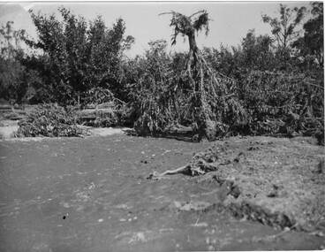
... Destruction caused in the Burnley orchards by the 1934 flood of the Yarra River. One large tree is upside down with its roots in the air....Destruction caused in the Burnley orchards by the 1934 flood of the Yarra River. One large tree is upside down with its roots in the air. ...Appears as an illustration in, "Green Grows Our Garden," A.P. Winzenried p 66. On p. 66 of the text there is further information about the effects of the flood.Black and white photograph. Destruction caused in the Burnley orchards by the 1934 flood of the Yarra River. One large tree is upside down with its roots in the air.On reverse, "1934."orchard, green grows our garden, a.p. winzenried, flood damage, fruit trees -
 Kew Historical Society Inc
Photograph, Flooding of the Outer Circle Railway Bridge, 1934
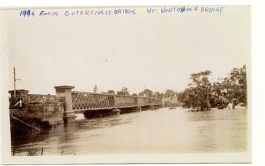
... floods - kew - 1934...1934 FLOODS / OUTER CIRCLE BRIDGE / WE WENT UNDER BRIDGE OUTER CIRCLE BRIDGE / 1934 FLOODS / (DAD & I) / WE TOOK OUR CANOE UNDER THE BRIDGE, & CARL SIERAKOSKI WAS IN HIS CANOE AT THE TIME & WROTE DADS NAME A. ...Kew Historical Society Inc Kew Court House 188 High Street Kew melbourne floods - kew - 1934 1934 FLOODS / OUTER CIRCLE BRIDGE / WE WENT UNDER BRIDGE OUTER CIRCLE BRIDGE / 1934 FLOODS / (DAD & I) / WE TOOK OUR CANOE UNDER THE BRIDGE, & CARL SIERAKOSKI WAS IN HIS CANOE AT THE TIME & WROTE DADS NAME A. ...One of three digital copies of flooded areas of Kew (1923-34), donated by Jan Coutts of Bulleen in 2019. The handwriting on the originals predates the copy.1934 FLOODS / OUTER CIRCLE BRIDGE / WE WENT UNDER BRIDGE OUTER CIRCLE BRIDGE / 1934 FLOODS / (DAD & I) / WE TOOK OUR CANOE UNDER THE BRIDGE, & CARL SIERAKOSKI WAS IN HIS CANOE AT THE TIME & WROTE DADS NAME A. LUCKE UNDER THE TOP OF THE BRIDGE / NEE (MARY LUCKE) NOW TYACKfloods - kew - 1934 -
 Kew Historical Society Inc
Photograph, Chipperfield's Boat House & Floating Pontoon, 1934
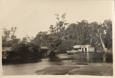
... Newspapers continued to describe major flooding in Kew in 1863, 1869, 1878, 1880, 1889, 1891, 1916 and 1934. While the construction of the Upper Yarra dam in 1957 reduced the levels of flowing downstream, local and riverine floods continue. ...Floating pontoon at Chipperfield's Boat House where the canoes were stored, taken in 1934, presumably before the 1934 Flood. This area of the Yarra was shallow with a number of mid river sandbanks and a popular swimming area for locals....Numerous photographs record flooding throughout the Twentieth Century. yarra river chipperfield's boathouse pontoon Floating pontoon at Chipperfield's Boat House where the canoes were stored, taken in 1934, presumably before the 1934 Flood. ...Living with natural processes was frequently a challenge to early European settlers and later residents of what was in the 1850s administered by the Borondara Road Board. This was compounded by the area being bounded on three sides by rivers (Yarra River, Koonung Creek and Gardiner's Creek). In 1849, the historian James Bonwick recorded that "our district [Kew] suffered considerably. Mr Wade speaks of 80 acres, out of 100 acres of his cultivated paddock, covered by water." Newspapers continued to describe major flooding in Kew in 1863, 1869, 1878, 1880, 1889, 1891, 1916 and 1934. While the construction of the Upper Yarra dam in 1957 reduced the levels of flowing downstream, local and riverine floods continue. A number of boat houses operated on both sides of the River Yarra at Kew. Chipperfield's Boat House was located on the Yarra near the corner of Kilby and Willsmere Roads.The Kew Historical Society's pictures and map collections testify to the impact of flooding in the district. They have historical importance in documenting the extent of flooding in the district and its affects on homes, services and recreation. Numerous photographs record flooding throughout the Twentieth Century.Floating pontoon at Chipperfield's Boat House where the canoes were stored, taken in 1934, presumably before the 1934 Flood. This area of the Yarra was shallow with a number of mid river sandbanks and a popular swimming area for locals.yarra river, chipperfield's boathouse, pontoon -
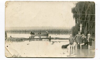
 Orbost & District Historical Society
black and white photograph, 1934
... Snowy-River-Orbost flood-1934 river-transport-punt...Damage estimated at £500,000 was caused by the 1934 floods in the Orbost district. This 1934 flood was devastating, destroying a section of the 1922 Orbost bridge, wrecking fences, bridges and roads, dumping silt and debris on the rich river flats and drowning cattle. ...Damage estimated at £500,000 was caused by the 1934 floods in the Orbost district. This 1934 flood was devastating, destroying a section of the 1922 Orbost bridge, wrecking fences, bridges and roads, dumping silt and debris on the rich river flats and drowning cattle. ...This photograph shows vehicles and people being ferried across the Snowy River during the 1934 flood. The Orbost punt was reinstated on a temporary basis following damage to the bridge. Damage estimated at £500,000 was caused by the 1934 floods in the Orbost district. This 1934 flood was devastating, destroying a section of the 1922 Orbost bridge, wrecking fences, bridges and roads, dumping silt and debris on the rich river flats and drowning cattle. The centre span of the Orbost Bridge was washed away.This is a pictorial record of the effects of the 1934 floods in the Orbost district.A large black / white photograph of a punt with a motor vehicle and people making their way across a river.on front - "On the Snowy 1934"snowy-river-orbost flood-1934 river-transport-punt -
 Orbost & District Historical Society
black and white photograph, 1934
... floods-orbost-1934 nixon-william johnston-charles...Damage estimated at £500,000 was caused by the 1934 floods in the Orbost district. This 1934 flood was devastating, destroying a section of the 1922 Orbost bridge, wrecking fences, bridges and roads, dumping silt and debris on the rich river flats and drowning cattle....Damage estimated at £500,000 was caused by the 1934 floods in the Orbost district. This 1934 flood was devastating, destroying a section of the 1922 Orbost bridge, wrecking fences, bridges and roads, dumping silt and debris on the rich river flats and drowning cattle. ...This photograph was taken during the flood of 1934 in Orbost. The people in the photograph are related to Billie and Ilma Nixon and Charlie Johnston. Damage estimated at £500,000 was caused by the 1934 floods in the Orbost district. This 1934 flood was devastating, destroying a section of the 1922 Orbost bridge, wrecking fences, bridges and roads, dumping silt and debris on the rich river flats and drowning cattle.This item is a pictorial record of a significant event in Orbost's history. It is associated with local families.A black / white photograph / postcard of floodwaters. On the right is a young man with four young boys sitting on a log. In the bckground is a rowing boat with one man rowing and three others sitting on the edges . A field of maize / corn is in the background and a large willow tree on the right.on back - "M. C. Rice Orbost 19 /1/20 M Gilbert. Mostly Billy Nixons & Charlie Johnstons 1934" [Note alteration: W C Rice rather than M C Rice].floods-orbost-1934 nixon-william johnston-charles -
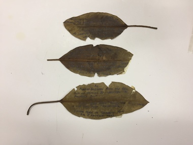 Kew Historical Society Inc
Plant specimen, Dorothy Rogers, Inscribed Moreton Bay Fig Leaves, Hawthorn (Vic), c.1960s
... ...1934 flood - melbourne - hawthorn (vic)...1974.0010.1 "Moreton Bay fig leaf from old tree foot of Derham St Haw - vicinity Palmer's Punt until 1934 flood & hut for Punt passengers was still there. ...Kew Historical Society Inc Kew Court House 188 High Street Kew melbourne Collected by the historian Dorothy Rogers denham street - hawthorn (vic) palmer's punt invergowrie - hawthorn 1934 flood - melbourne - hawthorn (vic) 1974.0010.1 "Moreton Bay fig leaf from old tree foot of Derham St Haw - vicinity Palmer's Punt until 1934 flood & hut for Punt passengers was still there. ...Collected by the historian Dorothy RogersDried Moreton Bay fig leaves from the vicinity of Palmer's Punt near Denham Street Hawthorn. Each leaf was inscribed by the historian Dorothy Rogers (sic) before 1973. The leaves are brittle and undated, with the text difficult to decipher. 1974.0010.1 "Moreton Bay fig leaf from old tree foot of Derham St Haw - vicinity Palmer's Punt until 1934 flood & hut for Punt passengers was still there. KH-355." 1974.0010.2 "Moreton Bay fig leaf from old tree foot of Denham St haw - vicinity Palmer's Punt until 1934 flood hut for punt passengers still existed there. A canoe tree in garden from Sir J. Palmer's land. KH-355." 1974.0010.3 "Moreton Bay fig leaf from old tree foot of Denham St leading to Palmer's Punt until 1934 flood there was still there a hut for punt passengers. Canoe tree in gardens from Sir J. Palmer's land. KH-355."denham street - hawthorn (vic), palmer's punt, invergowrie - hawthorn, 1934 flood - melbourne - hawthorn (vic)