Showing 52 items matching "60 feet"
-
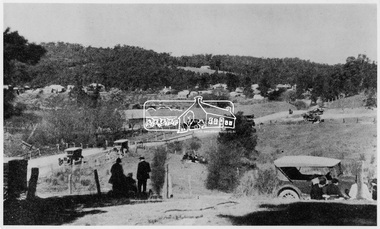
 Ringwood RSL Sub-Branch
Souvenir - The Dam Busters Plate 3, hold it at 60 feet
... hold it at 60 feet...Hold it at 60 feet...Ringwood RSL Sub-Branch 16 Station Street Ringwood melbourne Hold it at 60 feet Souvenir Plate hold it at 60 feet Souvenir The Dam Busters Plate 3 ...Souvenir PlateHold it at 60 feet -
 Ringwood and District Historical Society
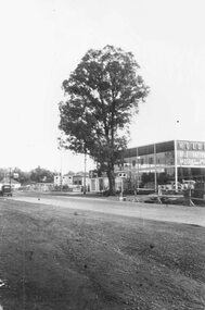
Photograph, Maroondah Highway West, Ringwood- The last remaining naturally grown gum tree on the Maroondah Highway between Ringwood and the city, cut down 1959. before it was cut down from out the front of Bill Patterson Motors in 1959 - a yellow box tree 60 feet high and 75 years old
... before it was cut down from out the front of Bill Patterson Motors in 1959 - a yellow box tree 60 feet high and 75 years old....Was a yellow box tree 60 feet high and 75 years old."...Was a yellow box tree 60 feet high and 75 years old." Black and white photograph (2 copies) Maroondah Highway West, Ringwood- The last remaining naturally grown gum tree on the Maroondah Highway between Ringwood and the city, cut down 1959. before it was cut down from out the front of Bill Patterson Motors in 1959 - a yellow box tree 60 feet high and 75 years old. ...Black and white photograph (2 copies)Typed below one photograph: "The last remaining naturally grown gum tree on the Maroondah Highway between Ringwood and the city before it was cut down from out the front of Bill Patterson Motors in 1959. Was a yellow box tree 60 feet high and 75 years old." -
 Federation University Historical Collection
Document - Document - Design, E J Barker: University of Melbourne: Bachelor of Mechanical Engineering; Civil Engineering 1 and 1A; Design of Welded Plate Girder, 1946
... ...60 feet...Assessment No 2 Project was to design a welded plate girder required in a building to span between two steel columns which have to be spaced 60 feet centre to centre. It needs to carry its own weight plus specified loads. ...Barker Library (top floor) Mount Helen goldfields Assessment No 2 Project was to design a welded plate girder required in a building to span between two steel columns which have to be spaced 60 feet centre to centre. It needs to carry its own weight plus specified loads. ...Assessment No 2 Project was to design a welded plate girder required in a building to span between two steel columns which have to be spaced 60 feet centre to centre. It needs to carry its own weight plus specified loads. This was part of Civil Engineering 1A . Jack chose to do Engineering while still at Footscray Technical School as it gave access to Diploma Courses and tertiary studies. This enabled him to enter the University of Melbourne and do a Bachelor in Mechanical Engineering - 1945, 1946, and 1947. In 1948 he did a Diploma in Education at Melbourne University. From this path he was able to follow a career in teaching and his first appointment was at the School of Mines in Ballarat, (SMB) 1949. He became the first Vice Principal of SMB in 1960 and then Principal in 1964 to 1976. From 1976 to his retirement in 1987, he was the Foundation Director of Ballarat College of Advanced Education (BCAE). The Library building at Mount Helen Campus is named after him.Manila folder with design assessment. Written descriptions and detailed drawings.e j barker, jack barker, melbourne university, engineering, diploma of mechanical engineering, diploma of electrical engineering, school of mines ballarat, smb, diploma in education, vice principal, principal, foundation director, ballarat college of advanced education, bcae, bachelor of mechanical engineering, library, mount helen campus, engineering drawing, design, specifications, manufacture, civil engineering, welded plate girder, 60 feet, steel columns -
 Fire Services Museum of Victoria
Fire Escape - Wheeled Ladder, Curricle Ladder
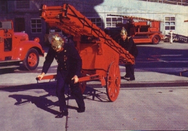
... Curricle Fire Escape Ladder hand or horse drawn 3 stage 60 feet extension...Fire Services Museum of Victoria Former Eastern Hill Fire Station 39 Gisborne St (corner of Victoria Parade) East Melbourne melbourne Curricle Fire Escape Ladder hand or horse drawn 3 stage 60 feet extension Curricle Ladder Fire Escape - Wheeled Ladder ...Curricle Fire Escape Ladder hand or horse drawn 3 stage 60 feet extension -
 Hume City Civic Collection
Photograph, c1934
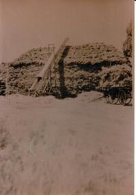
... on back in ink: HAYSTACK AT 'BAYVIEW'/ABOUT 1934 / 60' (feet) long, 20' (feet) high, 25' (feet) wide / ELEVATOR APPROX 25' (feet) long / 70-100 tons of hay / "Bayview" / 111 DAVIS ROAD / DIGGERS REST 3427...Hume City Civic Collection 44 Macedon Street Sunbury melbourne cullinan uraina eileen chris bayview farm diggers rest farms farming clothing and dress harvesting haystacks george evans collection on back in ink: HAYSTACK AT 'BAYVIEW'/ABOUT 1934 / 60' (feet) long, 20' (feet) high, 25' (feet) wide / ELEVATOR APPROX 25' (feet) long / 70-100 tons of hay / "Bayview" / 111 DAVIS ROAD / DIGGERS REST 3427 A sepia photograph of a haystack being built with a bale elevator at the side and a hay cart at the end at Bayview Farm. ...A sepia photograph of a haystack being built with a bale elevator at the side and a hay cart at the end at Bayview Farm.on back in ink: HAYSTACK AT 'BAYVIEW'/ABOUT 1934 / 60' (feet) long, 20' (feet) high, 25' (feet) wide / ELEVATOR APPROX 25' (feet) long / 70-100 tons of hay / "Bayview" / 111 DAVIS ROAD / DIGGERS REST 3427cullinan, uraina, eileen, chris, bayview farm, diggers rest, farms, farming, clothing and dress, harvesting, haystacks, george evans collection -
 Bendigo Historical Society Inc.
Document - H.A. & S.R. WILKINSON COLLECTION: CONTRACT OF SALE
... Svanosio (buyer) for land situate in Sternberg Street, Bendigo, being lot 3 on plan of sub-division No. 13862, having a frontage of 60 feet by a depth of 107 feet. Price 40 pounds. ...Svanosio (buyer) for land situate in Sternberg Street, Bendigo, being lot 3 on plan of sub-division No. 13862, having a frontage of 60 feet by a depth of 107 feet. Price 40 pounds. ...This business was owned by father and son, Henry Archibald Wilkinson and Samuel Ronald "Ron" Wilkinson. Henry (1882-1954) was born in Shepparton and died in Bendigo. He was married to Grace Hovendon in 1908. Samuel Ronald "Ron" (1914-1995), Henry's son, was married to Florence Jean McKerlie in 1937.Conditions of sale by private contract dated 26th November, 1937 between Mrs. R.E. Mahon (seller) and N.L. Svanosio (buyer) for land situate in Sternberg Street, Bendigo, being lot 3 on plan of sub-division No. 13862, having a frontage of 60 feet by a depth of 107 feet. Price 40 pounds. Attached a drawing of the sub-division.organization, business, h.a. & s.r wilkinson real estate -
Ringwood and District Historical Society
Document, Ringwood and District Horticultural and Garden Club, City of Ringwood Garden Competition 1972, Entry Form, 1972
... Open (Gardener employed) Section 2. Amateur, over 60 feet Section 3. Amateur, under 60 feet. ...Open (Gardener employed) Section 2. Amateur, over 60 feet Section 3. Amateur, under 60 feet. Section 4. ...City of Ringwood Garden Competition 1972 Entry Form by the Ringwood and District Horticultural and Garden Club.Typed formCity of Ringwood Garden Competition 1972 Entry Form Section 1. Open (Gardener employed) Section 2. Amateur, over 60 feet Section 3. Amateur, under 60 feet. Section 4. Front Garden. Section 5. New Garden (under 3 years) Section 6. Vegetable Garden. Section 7. Native Garden or other than floral. Section 8. Special section. Gardeners over 65 years. Name: ...................................... Address: ........................................... Section No. Please complete and return before 23rd. February 1972 to Mrs. V.H.Wilson, Secretary, Ringwood & District Horticultural and Garden Club, 38 William St Ringwood. 3134. -
![Straus’ Falls, Cape Otway Ranges / [by] Nicholas Caire, circa 1876](/media/collectors/550653872162f11fb04854aa/items/57833e2ad0cdd1176c6791eb/item-media/57833ea7d0cdd1176c67b9d8/item-fit-380x285.jpg?cb=6) Kew Historical Society Inc
Kew Historical Society IncPhotograph, Anglo-Australasian Photographic Company, Straus’ Falls, Cape Otway Ranges, c. 1876
... They comprise a succession of falls, rapids, and cataracts varying from 10 feet to 60 feet, making a total of 250 feet from the fall to the bed of the stream. ...They comprise a succession of falls, rapids, and cataracts varying from 10 feet to 60 feet, making a total of 250 feet from the fall to the bed of the stream. ...Nicholas Caire was born on Guernsey in the Channel Islands in 1837. He arrived in Adelaide with his parents in about 1860. In 1867, following photographic journeys in Gippsland, he opened a studio in Adelaide. From 1870 to 1876 he lived and worked in Talbot in Central Victoria. In 1876 he purchased T. F. Chuck's studios in the Royal Arcade Melbourne. In 1885, following the introduction of dry plate photography, he began a series of landscape series, which were commercially successful. As a photographer, he travelled extensively through Victoria, photographing places few of his contemporaries had previously seen. He died in 1918. Reference: Jack Cato, 'Caire, Nicholas John (1837–1918)', Australian Dictionary of Biography.An original, rare photograph from the series 'Views of Victoria: General Series' by the photographer, Nicholas Caire (1837-1918). The 60 photographs that comprise the series were issued c. 1876 and reinforced a neo-Romantic view of the Australian landscape to which a growing nationalist movement would respond. Nicholas Caire was active as a photographer in Australia from 1858 until his death in 1918. His vision of the Australian bush and pioneer life had a counterpart in the works of Henry Lawson and other nationalist poets, authors and painters.‘Straus’ Falls, Cape Otway Ranges’ : Views of Victoria (General Series) No.55 : Albumen silver photograph | Photo on card with Title and Description on reverse | Mounted 24 x 30 cm; Photo 12 x 17 cm.On Reverse: ‘These Falls were discovered some time since by a gentleman named Straus, and were so named in memory of him. They comprise a succession of falls, rapids, and cataracts varying from 10 feet to 60 feet, making a total of 250 feet from the fall to the bed of the stream. These waters probably form a tributary to one of the adjacent rivers.’nicholas caire (1837-1918), landscape photography -
 Bendigo Historical Society Inc.
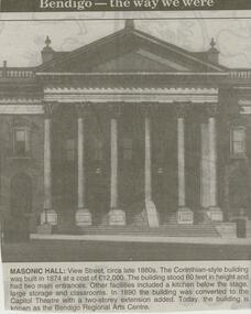
Newspaper - JENNY FOLEY COLLECTION: MASONIC HALL
... The building stood 60 feet in height and had two main entrances. ...The building stood 60 feet in height and had two main entrances. ...Bendigo Advertiser ''The way we were'' from 2000. Masonic hall: View Street, circa late 1880s. The Corinthian-style building was built in 1874 at a cost of 12,000 pounds. The building stood 60 feet in height and had two main entrances. Other facilities included a kitchen below the stage, large storage and classrooms. In 1990 the building was converted to the Capitol Theatre with a two-storey extension added. Today, the building is known as the Bendigo Regional Arts Centre. The clip is in a folder.newspaper, bendigo advertiser, the way we were -
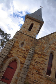 Ballarat Heritage Services
Photograph - church, St Mary's Catholic Church, Dunolly, 08/12/2012
... This gothic building is built from rubble stone, granite courses, and facings; and with its tower — some 60 feet high — stands out in bold relief, giving tone and importance to the south-east end of the town. ...This gothic building is built from rubble stone, granite courses, and facings; and with its tower — some 60 feet high — stands out in bold relief, giving tone and importance to the south-east end of the town. ...This church was built between 1868-71 and opened on 17/9/1871. The architect of the building was architect R. Dowden. This gothic building is built from rubble stone, granite courses, and facings; and with its tower — some 60 feet high — stands out in bold relief, giving tone and importance to the south-east end of the town. The foundation Stone was laid on 18/1/1869. The text of the foundation stone is not known. Information/photographs are invited. A stone in the tower wall records: 1871. Colour photograph os a stone church in Dunollydunolly, st mary's catholic church, r. dowden -
 Bendigo Historical Society Inc.
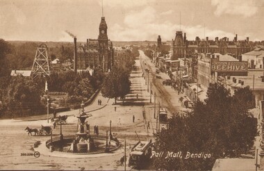
Postcard - BLACK AND WHITE PHOTO OF PALL MALL BENDIGO: EARLY DAYS TO LATE 1800'S
... Depth of shaft -1,660 feet, Formed 1885, closed 1917, Poppet legs - steel, 60 feet high. Winding engine: First motion, 24 in. ...Depth of shaft -1,660 feet, Formed 1885, closed 1917, Poppet legs - steel, 60 feet high. Winding engine: First motion, 24 in. ...Black and white Photo of Pall Mall Bendigo - early days - late 1800's - postcard -rear of card shows Royal Historical Society of Victoria Bendigo Branch - Hustlers Royal Reserve No.2 Locality; Pall Mall Bendigo RSL Memorial Hall now occupies site. Depth of shaft -1,660 feet, Formed 1885, closed 1917, Poppet legs - steel, 60 feet high. Winding engine: First motion, 24 in. Cylinders, 10ft. Drums. Gold Yield - 10,262 ozs .Dividends 3,200 pounds. / Photo shows Beehive sign.postcard, photograph, bendigo, pall mall bendigo - early days - late 1800's /--hustlers royal reserve no.2 locaility ; pall mall bendigo rsl memorial hall / beehive sign -
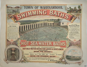 Flagstaff Hill Maritime Museum and Village
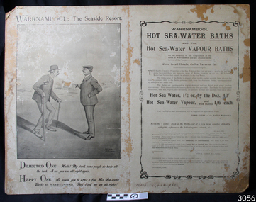
Poster - Recreation, Town of Warrnambool Swimming Baths, ca. May 1884
... A second bath, solely for ladies, was 60 feet long by 30 feet wide. Hot Sea water Baths were also part of the institution, and were sought after for their ‘wonderful curative powers’, and ‘incomparable’ as a ‘tonic for the feeble’. ...The Swimming Bath is 100 feet long by 50 feet wide, of graduating depth; and a second bath for ladies' use solely, 60 feet long by 30 feet wide. The hot Sea-water Baths in connection with this institution have been extolled far and wide for their wonderfully curative powers in cases of rheumatism, sciatica, and nervous afflictions generally. ...A second bath, solely for ladies, was 60 feet long by 30 feet wide. Hot Sea water Baths were also part of the institution, and were sought after for their ‘wonderful curative powers’, and ‘incomparable’ as a ‘tonic for the feeble’. ...The poster advertises these Swimming Baths as “the most complete in the Southern Hemisphere”. In February 1877 a Baths Company (1050 shares) was formed in the town of Warrnambool for the establishment of the baths at the south end of Gillies Street. The baths were filled with sea water from Lady Bay, originally pumped by a windmill situated near the current Surf Lifesaving Club and carried by iron pipes to the Public Baths; later the water was pumped by a gas motor. Hot and cold fresh water baths were advertised. The gentlemen’s bath was 100 feet long and 50 feet wide, of graduating depth. A second bath, solely for ladies, was 60 feet long by 30 feet wide. Hot Sea water Baths were also part of the institution, and were sought after for their ‘wonderful curative powers’, and ‘incomparable’ as a ‘tonic for the feeble’. In June 1881 the Hot Sea Baths were opened, and both hot and cold water baths were supplied at reasonable charges. Patrons came from near and far to receive the benefits. The manager of the Baths was J. Kirkpatrick. The Baths Company struggled for several years without success, so in 1883 the baths were sold to the Borough Council for 1250 pounds. The original shareholders received nothing for their outlay; the overdraught was over the sale price. In May 1884 the Council announced that an estimated they has spent 1000 pounds in improving the baths since purchasing them and were now returning an income of 11 per cent. Historically significant to Warrnambool and the recreational facilities available in the 1880s to 1900s. The remains of the baths are still visible to the public today.Poster on heavy cream paper, landscape orientation, with coloured print. The poster advertises the Warrnambool Swimming Baths. It has several drawings such as Middle Island and the Merri River Mouth with vessels in the water, The inside of the Baths facility, the men's baths with the adjacent bathing rooms and figures in and out of the water, a cottage with figures in the garden, and fenced buildings with a windmill and aqueduct or pipes. The text describes the location and advantages, the opening times and various costs. It was printed in Ballarat by F.W. Niven & Co. Lithos."TOWN OF WARRNAMBOOL" "SWIMMING BATHS" "HOT SALT-WATER BATHS FOR LADIES AND GENTLEMEN" "HOURS FOR BATHING fROM 7 a.m. to 9 p. m. Closed on Sundays at 10 a.m." Single Bath 1s [1 shilling]; or 10s per Dozen Tickets" "HOURS FOR SWIMMING BATHS: Ladies and Gentlemen, from 6 a.m. to Sunset, Sundays 6 a.m. to 10 a.m." "Every information can be obtained from the Manager, J. Kirkpatrick" "HOT SEA-WATER BATHS ... strongly recommended by the Medical Faculty" "Hot and Cold Fresh Water Baths" "Showers etc." "LIST OF CHARGES ... Single Season Ticket, Single Monthly Ticket, Single Bath without towel ... with towel.. Tickets per dozen without towel, with towel..." "The Baths are situated at the end of Gillies Street, in the rear of the Post Office, and are of salt water pumped by gas motor continuously from the sea. The Swimming Bath is 100 feet long by 50 feet wide, of graduating depth; and a second bath for ladies' use solely, 60 feet long by 30 feet wide. The hot Sea-water Baths in connection with this institution have been extolled far and wide for their wonderfully curative powers in cases of rheumatism, sciatica, and nervous afflictions generally. As a tonic to an enfeebled system, they are incomparable, These Baths, the most complete in the Southern Hemisphere, have been recently re-erected and fitted with marble plunges, and everything provided for the comfort and convenience of invalids and visitors." "F.W. NIVEN & Co, LITHOS, BALLARAT"flagstaff hill, warrnambool, warrnambool swimming baths, hot sea water baths warrnambool, warrnambool baths company, f.w. niven & co, warrnambool therapudic baths, town of warrnambool, swimming baths, hot sea water baths, salt water baths, ladies' baths, gentlemen's baths, warrnambool town baths, j kirkpatrick -
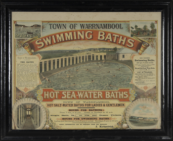 Warrnambool and District Historical Society Inc.
Photograph - Framed photograph of Warrnambool Salt Water Baths, c. 1920
... The men's pool was 100 feet by 50 feet and the women's pool was 60 feet by 30 feet with bathing strictly segregated in the 19th century. ...The men's pool was 100 feet by 50 feet and the women's pool was 60 feet by 30 feet with bathing strictly segregated in the 19th century. ...This is a framed photograph of the men's pool at the Warrnambool Salt Water Baths. These Baths were originally built at the end of Gilles Street on the line of the present railway line in 1876 but were rebuilt in 1889 further north in Gilles Street when the railway line was opened. The water was pumped from the sea, initially by a windmill and later by a gas pump. The men's pool was 100 feet by 50 feet and the women's pool was 60 feet by 30 feet with bathing strictly segregated in the 19th century. A building nearby housed marble cubicles with hot spa baths with the water heated on the site and a caretaker's cottage completed the complex. Men's nude bathing was a feature of the early 20th century. Originally built by a local public company the Baths were taken over by the Warrnambool Council. These baths were superseded by the opening in 1961 of an Olympic Pool In Warrnambool. The site and the remaining buildings of the old sea water baths are now heritage-listed and today form part of the headquarters of the Warrnambool and District Historical Society.This photograph is of historical significance as a depiction of the Warrnambool Salt water Baths in the early 20th century. These Baths were the basis for promoting Warrnambool as a health and spa resort town in the late 19th and early 20th centuries.This is a framed black and white photograph of the men's pool at the Warrnambool Salt Water Baths. It depicts men and boys swimming in the circular pool and one male on the diving board. All these men are naked. There are other clothed males and clothed attendants wearing hats and waistcoats. The change rooms are on the right side of the photograph and there is a fence with trees behind. The photograph is mounted on cardboard with a gilt edge and is held in a wooden ridged frame behind glass. warrnambool sea water baths, sea baths, warrnambool pool, gilles street -
 Bendigo Historical Society Inc.
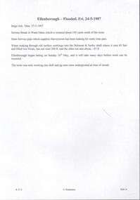
Document - DRAINAGE PROBLEMS - ELLENBOROUGH FLOODED
... Water soaking through old surface workings into the Belmont and Saxby shaft where it rose 60 feet and filled two x-cuts, one out west 208 ft, and the other out east about 45 ft. ...Water soaking through old surface workings into the Belmont and Saxby shaft where it rose 60 feet and filled two x-cuts, one out west 208 ft, and the other out east about 45 ft. ...The Ellenborough mine was located on Snob's Hill in Eaglehawk, near Bendigo, Victoria, Australia. It was a notable mine operating on the New Chum line of reef in the Eaglehawk District. The Ellenborough Mine was the first mine in the world to use electricity to light above and underground. On 12th October 1882, the installation of the lighting system was completed by the Australian Electric Light Company. 'The whole of the levels and back have been lighted so that candles have been dispensed with ....the engine house, blacksmith''s shop and brace are also lighted at night' (Bendigo Advertiser, 13th October, 1882). 'The electricity is generated in an ordinary electric battery placed in the engine-house, and driven by a three horse power " Soho" engine. This engine is supplied with steam by a pipe leading from the steam pipe used to supply the air-compressor. It can be driven at full power with a pressure of 351bs of steam, with the engine wheel moving at the rate of 220 revolutions per minute; the battery wheel makes 850 revolutions. The plant occupies very little space. The battery is a to-light machine; that is, it can supply sufficient electricity for 35 lights. Whether there is only one light burning or 35, there is no necessity to alter the machine or the speed, and there is no danger of one light becoming too powerful because all the rest are put out. There is no danger, as many people suppose, in taking hold of the wires, even if uncovered, for the engineer last evening plainly demonstrated that where the shock was greatest it was very mild, and could hardly be felt'.Handwritten copy of a report in the Bendigo Advertiser 24/5/1907. ''Serious break in Water Main which is situated about 100 yards south of the mine. Main service pipe which supplies Harvey town has been leaking for some time past. Water soaking through old surface workings into the Belmont and Saxby shaft where it rose 60 feet and filled two x-cuts, one out west 208 ft, and the other out east about 45 ft. Ellenborough began baling on Sunday 26th May, and it will take many days before work can be resumed. The mine was only working one shift and no men were underground at time of in rush''. Document from Albert Richardson Collection of mining history.document, gold, drainage problems, ellenborough flooded, bendigo advertiser, 27/5/1907, harveytown, belmont & saxby, ellenborough, albert richardson, electricity -
 Bendigo Historical Society Inc.
Document - ROBERT CARR: CORRESPONDENCE AND LIFE HISTORY INFORMATION
... In the year 1873 he fell 60 feet down an abandoned shaft and not badly hurt. ...In the year 1873 he fell 60 feet down an abandoned shaft and not badly hurt. ...Robert Carr - correspondence to BHS and life history information sent back to writer re Carr (Great Extended Hustlers). Robert Carr was born Magherfelt Ulster 1833 and educated in agricultural pursuits. He arrived at Eaglehawk (part of Sandhurst) 4 miles from Bendigo in 1853 and began alluvial mining in 1855. Robert was on the committee to establish the Presbyterian Church at Eaglehawk. Robert began reef mining at Hustlers and Extended Hustlers mines and was manager in 1881. Robert was also a past Secretary of Oddfellows. In the years 1871-2 the mine yielded marvellous cakes of gold. He was a model mine manager. During 1872 he was on the committee of School of Mines. In the year 1873 he fell 60 feet down an abandoned shaft and not badly hurt. Robert died in May 1893, aged 60 years, and at the time of death was director of Great Extended Hustlers, Hustlers Company. 'A person of uprightness, frankness and integrity.'person, individual, robert carr, presbyterian church eaglehawk, hustlers, extended hustlers and great extended mines, oddfellows, school of mines bendigo. -
 Bendigo Historical Society Inc.
Photograph - PALL MALL, BENDIGO, c1903-1918
... Poppet Legs - Steel, 60 feet high. Winding engine: First motion, 24 in. ...Poppet Legs - Steel, 60 feet high. Winding engine: First motion, 24 in. ...Two identical post cards: 'Pall Mall', Bendigo streetscape, fountain in foreground, horse-drawn cab, cable trams, Hustler's Royal Reserve Mine, Post Office, Henderson & Goodisson Beehive sign clearly visible. Physical description: loose photograph, sepia. Inscriptions markings: on back of photo - The 'Valentine & Sons' Publishing Co., Ltd., Melbourne. POST CARD. Printed in Great Britain. This space to be used for communication. The Address only to be written here. On front - Pall Mall, Bendigo. Also 300.336 then the letters JK in a circle. On back of the second postcard: Royal Historical Society of Victoria, Bendigo Branch. Hustlers Royal Reserve No.2 data. Hustlers Royal, Pall Mall, Bendigo. RSL Memorial Hall now occupies site. Depth of Shaft - 1,660 feet. Formed 1885; Closed 1917. Poppet Legs - Steel, 60 feet high. Winding engine: First motion, 24 in. Cylinders, 10ft. Drums. Gold yields - 10,262 oz. Dividends 3,200 pounds.The Valentine & Sons' Publishing Co., Ltd., Melbournebendigo, pall mall, rhsv, hustlers royal reserve -
![State School, Fernshawe / [by] Nicholas Caire, circa 1876](/media/collectors/550653872162f11fb04854aa/items/5777443dd0cdd10a5c0fa4c9/item-media/57774498d0cdd10a5c0fd7bf/item-fit-380x285.jpg?cb=6) Kew Historical Society Inc
Kew Historical Society IncPhotograph, State School, Fernshawe, c. 1876
... In the centre of the picture stands a stump, about 60 feet / high, which has evidently been struck by lightning. ...In the centre of the picture stands a stump, about 60 feet / high, which has evidently been struck by lightning. ...Nicholas Caire was born on Guernsey in the Channel Islands in 1837. He arrived in Adelaide with his parents in about 1860. In 1867, following photographic journeys in Gippsland, he opened a studio in Adelaide. From 1870 to 1876 he lived and worked in Talbot in Central Victoria. In 1876 he purchased T. F. Chuck's studios in the Royal Arcade Melbourne. In 1885, following the introduction of dry plate photography, he began a series of landscape series, which were commercially successful. As a photographer, he travelled extensively through Victoria, photographing places few of his contemporaries had previously seen. He died in 1918. Reference: Jack Cato, 'Caire, Nicholas John (1837–1918)', Australian Dictionary of Biography.An original, rare photograph from the series 'Views of Victoria: General Series' by the photographer, Nicholas Caire (1837-1918). The series of 60 photographs that comprise the series was issued c. 1876 and reinforced a neo-Romantic view of the Australian landscape to which a growing nationalist movement would respond. Nicholas Caire was active as a photographer in Australia from 1858 until his death in 1918. His vision of the Australian bush and pioneer life had a counterpart in the works of Henry Lawson and other nationalist poets, authors and painters.Albumen Silver Photograph mounted on boardprinted in ink on support l.c.: STATE SCHOOL, FERNSHAWE. / COPYRIGHT REGISTERED. printed in ink on support reverse c.: VIEWS OF VICTORIA. / (GENERAL SERIES.) / No. 5. / STATE SCHOOL, FERNSHAWE. / This educational institution occupies one of the most romantic situations of any of the State Schools in Victoria. / On either side of it runs a river and a creek, whilst immediately surrounding it are a great many large fern trees. / The background comprises many giants of the forest. In the centre of the picture stands a stump, about 60 feet / high, which has evidently been struck by lightning. The neighbourhood, not being a very populous one, furnishes / but 30 children for educational training. printed in ink on support reverse l.c.l.: J.W. FORBES, Agent, printed in ink on support reverse l.c.: ANGLO-AUSTRALASIAN PHOTOGRAPHIC COMPANY, MELBOURNE printed in ink on support reverse l.c.r.: 10 Temple Court, Collins Street West.nicholas caire (1837-1918), landscape photography -
 Flagstaff Hill Maritime Museum and Village
Poster - Recreation, Warrnambool Hot Sea Water Baths, c. November 1908
... A second bath, solely for ladies, was 60 feet long by 30 feet wide. Hot Sea-water Baths were also part of the institution, and were sought after for their ‘wonderful curative powers’, and ‘incomparable’ as a ‘tonic for the feeble’. ...A second bath, solely for ladies, was 60 feet long by 30 feet wide. Hot Sea-water Baths were also part of the institution, and were sought after for their ‘wonderful curative powers’, and ‘incomparable’ as a ‘tonic for the feeble’. ...The poster includes a cartoon by Arthur Jordan, with a conversation between an ailing man and a good man after baths visits. There are several reviews dating from 1906 to 1908 extolling the healing powers of the baths' waters. In February 1877 a Baths Company (1050 shares) was formed in the town of Warrnambool for the establishment of the baths at the south end of Gillies Street. The baths were filled with sea water from Lady Bay, originally pumped by a windmill situated near the current Surf Lifesaving Club and carried by iron pipes to the Public Baths; later the water was pumped by gas motor. Hot and cold fresh water baths were advertised. The gentlemen’s bath was 100 feet long and 50 feet wide, of graduating depth. A second bath, solely for ladies, was 60 feet long by 30 feet wide. Hot Sea-water Baths were also part of the institution, and were sought after for their ‘wonderful curative powers’, and ‘incomparable’ as a ‘tonic for the feeble’. In June 1881 the Hot Sea Baths were opened, and both hot and cold water baths were supplied at reasonable charges. Patrons came from near and far to receive the benefits. The manager of the Baths was J. Kirkpatrick. The Baths Company struggled for several years without success so in 1883 the baths were sold to the Borough Council for 1250 pounds. The original shareholders received nothing for their outlay; the overdraught was over the sale price. In May 1884 the Council announced that an estimated they has spent 1000 pounds in improving the baths since purchasing them and were now returning an income of 11 per cent. The poster promotes the healing powers of the hot sea water baths that were in use in Warrnambool in the late 19th century through to the early 20th century. The baths were a place for fitness, health and social activity, an example of the recreational activities during this period.Poster, black and white, mounted on card. It shows advertising Warrnambool Sea-water Baths and Hot Sea-water Baths. There are several references promoting the health benefits of baths, dating from 1906-1908. The cartoon was sketched by Arthur Jordan. The poster was printed by The Thompson Printing Co. Warrnambool. Handwritten inscription on the lower edge.Handwritten "10,000 mailed by post through Victoria"flagstaff hill, warrnambool, shipwrecked-coast, flagstaff-hill, flagstaff-hill-maritime-museum, maritime-museum, shipwreck-coast, flagstaff-hill-maritime-village, warrnambool salt baths, warrnambool therapudic baths, arthur jordan, baths company, sea water baths, hot sea water, swimming, healing powers, warrnambool baths, advertisement, thompson printing co. warrnambool -
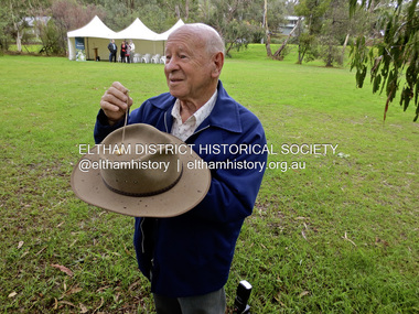
 Eltham District Historical Society Inc
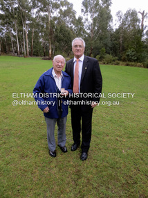
Photograph - Medal, Jim Connor, Doug Orford with Minister Damian Drum, Minister for Veterans' Affairs at Wingrove Park, Eltham, 22 April 2014
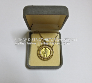
... The explosions, including those at the heavily contested Hill 60, created craters 60 feet deep, killed roughly 10,000 German troops, and were heard as far away as London. ...The explosions, including those at the heavily contested Hill 60, created craters 60 feet deep, killed roughly 10,000 German troops, and were heard as far away as London. ...Awarded to Spr. W. H. Orford by Shire of Eltham Welcome Home Committee Welcome Home Medal The Welcome Home Medal was issued to acknowledge service during World War 1. As groups of servicemen returned and were discharged a local welcome home function was held in their honour. The welcome home committee decided that to commemorate the occasion a medal should be presented to the returned servicemen and also to the nearest relations of those who had fallen during the conflict. The medal shown was presented to Sapper William Henry Orford, of the 2nd Australian Tunnelling Company, an uncle of Doug Orford, one of our members. Sapper Orford participated in an operation where on June 7, 1917, British and Australian tunnellers detonated 19 massive mines beneath German lines at Messines Ridge, Belgium, marking a pivotal moment in WWI underground warfare. The explosions, including those at the heavily contested Hill 60, created craters 60 feet deep, killed roughly 10,000 German troops, and were heard as far away as London. Tunnellers from Australian and British units worked for over a year (since 1916) in treacherous conditions—including quicksand and mud—to dig tunnels beneath German strongpoints. At 3:10 a.m. on June 7, nearly 1,000,000 pounds of explosives (ammonal) were detonated, creating one of the largest pre-atomic explosions in history The explosions shattered German morale and destroyed defences, allowing Allied forces to take the ridge. Specifically, Australian miners placed, at great risk, two massive mines under the German-held Hill 60 and the nearby "Caterpillar" crater. Inscribed on the front of the medal is: SPR W.H. ORFORD FROM ELTHAM WE HONOUR YOU GREAT WAR 1914 – 1919 On the back of the medal is the image of a soldier standing at ease with a rifle. Smaller than originally stated the Eltham Districts medal is midway between a 10 and 20 cent piece in size. The medal is a fine piece of craftsmanship and is understood to have cost £4 to make. On 22nd April 2014 Society members were pleased to attend an announcement by Mr Damien Drum, Victorian Minister for Veterans Affairs and Sport, of funding for installation of signage for the Eltham and Hurstbridge Avenues of Honour. Doug Orford was there and created much interest with his Welcome Home Medal, including from Minister Drum. See also EDHS Newsletter No. 216 May 2014spr. w.h. orford, welcome home committee, welcome home medal, world war 1, avenue of honour, jim connor collection, mr damien drum, victorian minister for veterans affairs and sport, william henry orford -
 Eltham District Historical Society Inc
Photograph - Medal, Jim Connor, Welcome Home Medal awarded to Spr. W. H. Orford by Shire of Eltham Welcome Home Committee, 22 April 2014
... The explosions, including those at the heavily contested Hill 60, created craters 60 feet deep, killed roughly 10,000 German troops, and were heard as far away as London. ...The explosions, including those at the heavily contested Hill 60, created craters 60 feet deep, killed roughly 10,000 German troops, and were heard as far away as London. ...Awarded to Spr. W. H. Orford by Shire of Eltham Welcome Home Committee Welcome Home Medal The Welcome Home Medal was issued to acknowledge service during World War 1. As groups of servicemen returned and were discharged a local welcome home function was held in their honour. The welcome home committee decided that to commemorate the occasion a medal should be presented to the returned servicemen and also to the nearest relations of those who had fallen during the conflict. The medal shown was presented to Sapper William Henry Orford, of the 2nd Australian Tunnelling Company, an uncle of Doug Orford, one of our members. Sapper Orford participated in an operation where on June 7, 1917, British and Australian tunnellers detonated 19 massive mines beneath German lines at Messines Ridge, Belgium, marking a pivotal moment in WWI underground warfare. The explosions, including those at the heavily contested Hill 60, created craters 60 feet deep, killed roughly 10,000 German troops, and were heard as far away as London. Tunnellers from Australian and British units worked for over a year (since 1916) in treacherous conditions—including quicksand and mud—to dig tunnels beneath German strongpoints. At 3:10 a.m. on June 7, nearly 1,000,000 pounds of explosives (ammonal) were detonated, creating one of the largest pre-atomic explosions in history The explosions shattered German morale and destroyed defences, allowing Allied forces to take the ridge. Specifically, Australian miners placed, at great risk, two massive mines under the German-held Hill 60 and the nearby "Caterpillar" crater. Inscribed on the front of the medal is: SPR W.H. ORFORD FROM ELTHAM WE HONOUR YOU GREAT WAR 1914 – 1919 On the back of the medal is the image of a soldier standing at ease with a rifle. Smaller than originally stated the Eltham Districts medal is midway between a 10 and 20 cent piece in size. The medal is a fine piece of craftsmanship and is understood to have cost £4 to make. On 22nd April 2014 Society members were pleased to attend an announcement by Mr Damien Drum, Victorian Minister for Veterans Affairs and Sport, of funding for installation of signage for the Eltham and Hurstbridge Avenues of Honour. Doug Orford was there and created much interest with his Welcome Home Medal, including from Minister Drum. See also EDHS Newsletter No. 216 May 2014spr. w.h. orford, welcome home committee, welcome home medal, world war 1, avenue of honour, jim connor collection, mr damien drum, victorian minister for veterans affairs and sport, william henry orford -
 Eltham District Historical Society Inc
Photograph - Medal, Jim Connor, Doug Orford with the Welcome Home Medal awarded to Spr. W. H. Orford by Shire of Eltham Welcome Home Committee, 22 April 2014
... The explosions, including those at the heavily contested Hill 60, created craters 60 feet deep, killed roughly 10,000 German troops, and were heard as far away as London. ...The explosions, including those at the heavily contested Hill 60, created craters 60 feet deep, killed roughly 10,000 German troops, and were heard as far away as London. ...Awarded to Spr. W. H. Orford by Shire of Eltham Welcome Home Committee Welcome Home Medal The Welcome Home Medal was issued to acknowledge service during World War 1. As groups of servicemen returned and were discharged a local welcome home function was held in their honour. The welcome home committee decided that to commemorate the occasion a medal should be presented to the returned servicemen and also to the nearest relations of those who had fallen during the conflict. The medal shown was presented to Sapper William Henry Orford, of the 2nd Australian Tunnelling Company, an uncle of Doug Orford, one of our members. Sapper Orford participated in an operation where on June 7, 1917, British and Australian tunnellers detonated 19 massive mines beneath German lines at Messines Ridge, Belgium, marking a pivotal moment in WWI underground warfare. The explosions, including those at the heavily contested Hill 60, created craters 60 feet deep, killed roughly 10,000 German troops, and were heard as far away as London. Tunnellers from Australian and British units worked for over a year (since 1916) in treacherous conditions—including quicksand and mud—to dig tunnels beneath German strongpoints. At 3:10 a.m. on June 7, nearly 1,000,000 pounds of explosives (ammonal) were detonated, creating one of the largest pre-atomic explosions in history The explosions shattered German morale and destroyed defences, allowing Allied forces to take the ridge. Specifically, Australian miners placed, at great risk, two massive mines under the German-held Hill 60 and the nearby "Caterpillar" crater. Inscribed on the front of the medal is: SPR W.H. ORFORD FROM ELTHAM WE HONOUR YOU GREAT WAR 1914 – 1919 On the back of the medal is the image of a soldier standing at ease with a rifle. Smaller than originally stated the Eltham Districts medal is midway between a 10 and 20 cent piece in size. The medal is a fine piece of craftsmanship and is understood to have cost £4 to make. On 22nd April 2014 Society members were pleased to attend an announcement by Mr Damien Drum, Victorian Minister for Veterans Affairs and Sport, of funding for installation of signage for the Eltham and Hurstbridge Avenues of Honour. Doug Orford was there and created much interest with his Welcome Home Medal, including from Minister Drum. See also EDHS Newsletter No. 216 May 2014spr. w.h. orford, welcome home committee, welcome home medal, world war 1, avenue of honour, jim connor collection, mr damien drum, victorian minister for veterans affairs and sport, william henry orford -
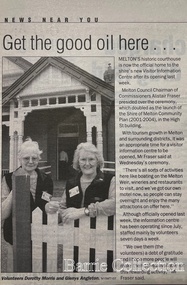 Melton City Libraries
Newspaper, Get the good oil here…, 2001
... A new shopping centre had recently been built at a setback of 60 feet (c.18 metre) from 323-329 High Street, and the court house, together with the adjacent weatherboard police station, had been left standing alone. ...A new shopping centre had recently been built at a setback of 60 feet (c.18 metre) from 323-329 High Street, and the court house, together with the adjacent weatherboard police station, had been left standing alone. ..."A court was established in Melton by 1864, when the first recorded case was heard before Mr BA Porter JP, with Mr A Carroll as the Clerk of Courts. John James was convicted of being drunk, for which he was fined five shillings or 24 hours imprisonment. The court was held in the ‘long room’ of the old Melton Hotel, before moving to rented accommodation at the Raglan Hotel, and finally to the Roads Board office. Tenders for construction of the present building were called for by the Public Works Department on 13th February 1892. The architect Samuel Edward Brindley was born in Birmingham, England, in 1842. He was articled to the local architect, J.R. Botham, FRIBA, before emigrating to Victoria where he was employed as an architect in the Education Department from 18 August 1873. With the amalgamation of the architectural branch of the Education Department with the Public Works Department in 1884, Bindley was placed in charge of Victorian government building design for the North-Western District. In 1975, the Melton and District Historical Society became concerned at hearsay that the court house was to be demolished to make way for carparking space. Melton had been declared a ‘satellite city’ and was developing rapidly. A new shopping centre had recently been built at a setback of 60 feet (c.18 metre) from 323-329 High Street, and the court house, together with the adjacent weatherboard police station, had been left standing alone. A new police station was planned, and the weatherboard police station was subsequently demolished. In its nomination of the building for National Trust classification the Society argued that the Court House was ‘the best of two early buildings left in the main street’ (the other being a bluestone hotel) and that its loss would be ‘tragic’. However the nomination was unsuccessful, the National Trust at the time judging that it was of no particular ‘distinction’ or ‘antiquity’. The building continued to be used as a court house at least until 1991 when the Department of Housing and Construction (formerly the PWD) conducted a heritage study of court houses. By this time Federation-era architecture had achieved acceptance within the heritage movement. The building was recognised as being ‘the only surviving example in brick of the Federation Queen Anne style which was used for court houses only twice.’ Twenty years later when it was proposed to modify the eastern façade of the building to accommodate a café, the M&DHS was again concerned. This time the National Trust objected that the proposed extension would be an over-development of the site, and questioned the changes to the interior court room furnishings and fittings. The site never appears to have been nominated to the Victorian Heritage Register. It has since been converted into the Shire of Melton Tourist Information Centre". Opening of the Visitor Centre in Meltoncouncil, local architecture -
 Bendigo Historical Society Inc.
Document - Hustlers, Sheepshead and Deborah lines of reef
... Collman and Tacchi, main shaft 2,588 feet, 60 yards west of Eaglehawk Road, California Gully. ...Collman and Tacchi, main shaft 2,588 feet, 60 yards west of Eaglehawk Road, California Gully. ...Albert Richardson was a mining historian who wrote widely on the mines of the Bendigo Goldfield. The park opposite the Goldmines Hotel in Marong Road, is named in his honour. Five page document, hand written by Albert Richardson on lined foolscap and edited with cross-outs and insertions, . The mines along the Hustlers line of reef and the Sheepshead line of reef are described. Mines listed on Hustlers line of reef: Fortuna Hustlers (1888 - 1913), shaft 2,240 feet at rear of Buckell and Jeffrey's offices; Royal Hustlers Reserve No. 2 - two shafts 'City" 860 feet, now covered by R.S.L. building Pall Mall, steel poppet legs 60 ft high and 'Park Shaft" at rear of Camp Hill School, 1,775 feet, steel poppet legs 60 feet high; Hustlers Hill Group first worked by Jonathan Harris in 1853 and bounded by Valentine, Anderson and Ironbark Creek to the north and Milroy Street to the east, one of first areas worked for quartz reefing. It with Garden Gully line west and Victoria Hill Ironbark, formed by far the richest cross section of the Bendigo Goldfield. Great Extended Hustlers (1865-1921) close to intersection of Anderson Street and Hustlers Road, mullock heap against road and shored up around shaft, steel poppet legs now at Wattle Gully mine, Chewton, large winding machine, air compressor south of shaft and 36 head crushing battery. Hustlers Reef (Old Hustlers) and Hustlers Reef No. 1, two shafts, main 2,210 feet, about 220 yards east of Moran Street and against Fenton Street. , No. 1 shaft 1,140 feet and about 155 yards east of Moran Street. Lansell's Comet, Lightining Hill line, 2.100 feet, on Comet Hill approx 70 yards west of Holmes Road, near Comet Creek, steel poppet legs. United Hustlers and Redan (1876-1918), main Redan, 1,830 feet about 155 yards west of Sandhurst Roead, in line with Comet Hill State School, this hill known as Redan Hill. North, or New Hustlers, once known as Agnew Hustlers, wooden poppet legs, south side, Kneebone Street, Eaglehawk. Derby line, Johnson's No. 3, South Johnson's (east shaft of Collman and Tacchi) 439 feet on west wide of Woods Street, south of Wetherall Street. Paddy's Gully Line, south to north, some shafts - Lansell's 'Sandhurst" ('Needle") Eaglehawk Road shaft 2,425 feet, about 50 yards east of Needle Loops, a brick square sided chimney with Cleopatra Needle top. British American, 789 feet, just south of Holdsworth Road. Collman and Tacchi, main shaft 2,588 feet, 60 yards west of Eaglehawk Road, California Gully. Deborah Line of Reef, The Deborah (1932-1954) shaft 2.017 feet, west of Adams Road and south of Abel Street, Quarry Hill. North Deborah (1937 - 1954) shaft 1,151 feet, Breen Street, Quarry Hill, steel poppet legs. Central Deborah (1939-1954) shaft 1,347 feet Sheepshead line of reef, Lansell's South Red, White and Blue, shaft 2,124 feet, north east of Bellevue Road and 220 yards east of Adams Road. The New Red, White and Blue Consolidated (Big Blue) main shaft 2,416 feet. Lansell's Bendigo Battery 105 head, north of 'Big Blue" on his freehold lease, commenced crushing on 24th February 1895. After closing was erected as the Showground's Industrial Hall, July 1926. North Red, White and Blue, burnt down February 1926, new company 1934, closed 1938. Document is part of the Albert Richardson Collection of Bendigo mining history. bendigo, gold mining, deborah line of reef, sheepshead line of reef, hustlers line of reef, royal hustlers reserve mine, hustlers hill group of mines, great extended hustlers, hustlers reef no. 1, lightning hill line, old comet, collman and tacchi, lansell's comet, north deborah, central deborah, dhrrpdhrsf linr og trrg, new red, white and blue consolidated mine, big blue, lansell's bendigo battery, north red, white and blue mine, albert richardson collection -
![View of the River Murray, near Echuca, showing the Railway Wharf with steamers unloading / [by] Nicholas Caire, circa 1876](/media/collectors/550653872162f11fb04854aa/items/57774776d0cdd10a5c111b2d/item-media/57774888d0cdd10a5c11c099/item-fit-380x285.jpg?cb=6) Kew Historical Society Inc
Kew Historical Society IncPhotograph, Anglo-Australasian Photographic Company, View of the River Murray, near Echuca, showing the Railway Wharf with steamers unloading, c. 1876
... The River here is about a quarter of a mile wide, / and is from 60 to 70 feet deep. printed in ink on support reverse l.c.l.: J.W. ...The River here is about a quarter of a mile wide, / and is from 60 to 70 feet deep. printed in ink on support reverse l.c.l.: J.W. ...Nicholas Caire was born on Guernsey in the Channel Islands in 1837. He arrived in Adelaide with his parents in about 1860. In 1867, following photographic journeys in Gippsland, he opened a studio in Adelaide. From 1870 to 1876 he lived and worked in Talbot in Central Victoria. In 1876 he purchased T. F. Chuck's studios in the Royal Arcade Melbourne. In 1885, following the introduction of dry plate photography, he began a series of landscape series, which were commercially successful. As a photographer, he travelled extensively through Victoria, photographing places few of his contemporaries had previously seen. He died in 1918. Reference: Jack Cato, 'Caire, Nicholas John (1837–1918)', Australian Dictionary of Biography.An original, rare photograph from the series 'Views of Victoria: General Series' by the photographer, Nicholas Caire (1837-1918). The series of 60 photographs that comprise the series was issued c. 1876 and reinforced a neo-Romantic view of the Australian landscape to which a growing nationalist movement would respond. Nicholas Caire was active as a photographer in Australia from 1858 until his death in 1918. His vision of the Australian bush and pioneer life had a counterpart in the works of Henry Lawson and other nationalist poets, authors and painters.albumen silver photograph on boardprinted in ink on support l.c.: VIEW ON THE RIVER MURRAY, NEAR ECHUCA, SHOWING THE RAILWAY WHARF WITH STEAMERS UNLOADING. / COPYRIGHT REGISTERED. printed in ink on support reverse c.: VIEWS OF VICTORIA. / (GENERAL SERIES.) / No. 7. / VIEW ON THE RIVER MURRAY, NEAR ECHUCA, SHOWING THE RAILWAY WHARF WITH STEAMERS UNLOADING. / The rapidly increasing traffic on the River Murray, with wool, timber, and other colonial produce, has called / into requisition no less than 400 steamers and over 1000 barges. To meet this growing emergency the Victorian / Government has expended several thousand pounds in the erection of a Railway Wharf which during the wool- / season presents a very busy scene, the crowded steamers laden with precious clip taxing to the utmost the / powers of the Railway Department in the process of unloading. The River here is about a quarter of a mile wide, / and is from 60 to 70 feet deep. printed in ink on support reverse l.c.l.: J.W. FORBES, Agent, printed in ink on support reverse l.c.: ANGLO-AUSTRALASIAN PHOTOGRAPHIC COMPANY, MELBOURNE. printed in ink on support reverse l.c.r.: 10 Temple Court, Collins Street West.nicholas caire (1837-1918), landscape photography, river murray, echuca -
 Eltham District Historical Society Inc
Photograph - Digital Photograph, Alan King, Original Kangaroo Ground Primary School No. 2105 building, Eltham-Yarra Glen Road, Kangaroo Ground, 28 December 2007
... But the farming community grew, until by 1878 the population warranted the building of State School No 2105 – the present one-roomed tongue-and-groove lined building measuring 49 feet x 18 feet (15m x 5.5m), to accommodate 60 children. The old school, No 352, was closed, and the new one opened on October 1, with Henry Wallace as head teacher, assisted by work mistress Annie Johnston. ...But the farming community grew, until by 1878 the population warranted the building of State School No 2105 – the present one-roomed tongue-and-groove lined building measuring 49 feet x 18 feet (15m x 5.5m), to accommodate 60 children. The old school, No 352, was closed, and the new one opened on October 1, with Henry Wallace as head teacher, assisted by work mistress Annie Johnston. ...Kangaroo Ground's first school began in 1851 with 22 pupils from the district's ten families. It was a single room school located further south on the site, which also served as a Presbyterian church. The first teacher was Andrew Ross. The school building was used as a Post Office between 1854 and 1858 and during 1857 also served as a Court of Petty Sessions. With a growing farming community, a new building was warranted and the original Sate School No. 352 was closed and a new building, State School No. 2105 was oipened October 1, 1878. A residence for Head Teacher Henry Wallace School was erected in 1879 attached to the left of the school building. That residence is now home to the Andrew Ross Museum, which opened in 1993. Covered under Heritage Overlay, Nillumbik Planning Scheme. Published: Nillumbik Now and Then / Marguerite Marshall 2008; photographs Alan King with Marguerite Marshall.; p35 In a corner of the Kangaroo Ground Primary School playground stands an old weatherboard building. This structure, attached to the former teacher’s weatherboard residence facing Main Road, first served as a school in 1878. The former residence, built in 1879, houses the Andrew Ross Museum, which opened in 1993. It is named after the school’s first teacher,1 who also founded The Evelyn Observer newspaper, which began on the site in 1873. Later the printing presses were moved to brick newspaper offices by the Kangaroo Ground Hotel, which became the Shire of Eltham offices. However Kangaroo Ground’s first school began in 1851 for 22 pupils from the district’s ten families, in a slab building further south on this site. Andrew Harkness and other settlers campaigned for the building, which was built on half an acre (0.2ha) donated by local farmer, James Donaldson. Builder was Samuel Furphy, father of the novelist Joseph.2 The single room measuring 30 feet x 18 feet (9m x 5.5m), was unlined and the green slabs shrank, allowing the wind and rain entry through cracks except when they were stuffed with paper.3 The building served as a Presbyterian church as well as a school, where fees were 18 pence a week for education. Young men also attended evening classes there in winter. At one stage, a corner of the room was curtained off for the schoolmaster’s living space, and the platform, which was used for sleeping, was also the pulpit during church services. Teacher Andrew Ross also took church services when the minister was unable to attend, which happened frequently as he had long distances to travel on the bad roads. In 1857 the school building was also used as the Court of Petty Sessions, and from 1854 until 1858, it served as a post office. During the gold rush fossickers on their way to the Caledonia Diggings at Queenstown (now St Andrews) prospected the district, but did not remain long, as the fields were not rich in gold. But the farming community grew, until by 1878 the population warranted the building of State School No 2105 – the present one-roomed tongue-and-groove lined building measuring 49 feet x 18 feet (15m x 5.5m), to accommodate 60 children. The old school, No 352, was closed, and the new one opened on October 1, with Henry Wallace as head teacher, assisted by work mistress Annie Johnston. Early teachers included Messrs Smith, Hamilton and Prosser, with sewing teachers Misses Sweeney, Limerock and Oliver. In the early 1920s a small room was built on the front veranda of the teacher’s residence, and used as a State Savings Bank agency until about 1934. In 1928 the schoolroom’s three-tiered floor was replaced by a flat floor and teacher’s platform (which has since been removed). A half-glassed partition wall then divided the large room into two rooms in which the old style form-type desks were replaced with dual desks. The small playground, surrounded by pine trees and a picket fence, was extended in 1931 with an additional acre or so (0.4 ha) of land. During World War Two the school faced closure because of a fall to seven in the enrolment, but by 1946 it had increased again to 45. Mr Eric Morgan was head teacher and Mrs Margaret Banks was assistant head teacher, a position she held for ten years. In 1955, under the head teacher Mr V Gardiner, who taught there for 13 years, the school won a prize for the best-kept garden and school ground in the inspectorate. A district subdivision increased the enrolment in 1968 to 65 and a bus service was established. After the hall which had been used for lessons was demolished late that year, the pupils met in the original fire brigade meeting room (now the tennis club, diagonally opposite the general store). The new school building with a storeroom and staffroom was built in 1974.This collection of almost 130 photos about places and people within the Shire of Nillumbik, an urban and rural municipality in Melbourne's north, contributes to an understanding of the history of the Shire. Published in 2008 immediately prior to the Black Saturday bushfires of February 7, 2009, it documents sites that were impacted, and in some cases destroyed by the fires. It includes photographs taken especially for the publication, creating a unique time capsule representing the Shire in the early 21st century. It remains the most recent comprehenesive publication devoted to the Shire's history connecting local residents to the past. nillumbik now and then (marshall-king) collection, kangaroo ground, andrew ross museum, eltham-yarra glen road, kangaroo ground primary school no. 2105, kangaroo ground state school, state school no. 2105 -
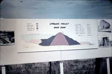 Bendigo Historical Society Inc.
Slide - DAVID MCDONALD COLLECTION: EPPALOCK. CONSTRUCTION, c1960
... Crest Length 2000 Feet, Maximum Height 150 Feet, Quantity Clay Fill 550 000 Ton, Quantity Gravel Filler 120000 Ton, Quantity Rock Filler 60 000 Ton, Quantity Basalt Rock Fill 250 000 Ton, Quantity Stabilizing Fill 150 000 Ton, Total Fill 1630 000 Ton. ...Crest Length 2000 Feet, Maximum Height 150 Feet, Quantity Clay Fill 550 000 Ton, Quantity Gravel Filler 120000 Ton, Quantity Rock Filler 60 000 Ton, Quantity Basalt Rock Fill 250 000 Ton, Quantity Stabilizing Fill 150 000 Ton, Total Fill 1630 000 Ton. ...Eppalock. Construction. Eppalock Project Main Bank. Lake consists of clay fill, Gravel Filter, Rock Filter, Basalt Filter, Stabilizing Fill. Full Supply Level RL637. Crest Length 2000 Feet, Maximum Height 150 Feet, Quantity Clay Fill 550 000 Ton, Quantity Gravel Filler 120000 Ton, Quantity Rock Filler 60 000 Ton, Quantity Basalt Rock Fill 250 000 Ton, Quantity Stabilizing Fill 150 000 Ton, Total Fill 1630 000 Ton. Markings: Eppalock Dam Observation Point Board.Agfacolorcivil engineering, water supply, eppalock -
 Bendigo Historical Society Inc.
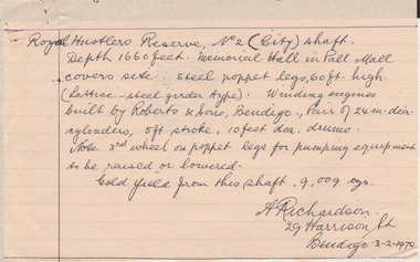
Document - ALBERT RICHARDSON COLLECTION: HANDWRITTEN report ROYAL HUSTLERS RESERVE
... feet. Memorial Hall in Pall Mall covers site. Steel poppet legs, 60 ft high (lattice-steel garden type). ...feet. Memorial Hall in Pall Mall covers site. Steel poppet legs, 60 ft high (lattice-steel garden type). ...Hand written letter signed by A. Richardson, 29 Harrison Street, Bendigo - 03/02/1970. Royal Hustler Reserve No. 2 (lift) shaft. Depth 1660 feet. Memorial Hall in Pall Mall covers site. Steel poppet legs, 60 ft high (lattice-steel garden type). Winding engines built by Roberts and Sons, Bendigo. Pair of 24 in. clear cylinders, 5ft stroke, 10ft ? drums. Note 3rd wheel on poppet legs for pumping equipment to be raised or lowered. Gold yield from this shaft 9,009 ounces.person, mining, albert richardson -
 Eltham District Historical Society Inc
Negative - Photograph, The Bridge, Hurstbridge, Vic, c.1925
... Advertised from £28.10.0 or £60 per block. In August 1926, 30 picked allotments of 60x150 feet were put up for auction Saturday August 14, 1926 with frontages to Valley View Road and Fawkner Crescent advertised in the “Heart of the Glorious Wattle Country” and “Within 15 Minutes of the Newly Electrified Railway Station”. ...Advertised from £28.10.0 or £60 per block. In August 1926, 30 picked allotments of 60x150 feet were put up for auction Saturday August 14, 1926 with frontages to Valley View Road and Fawkner Crescent advertised in the “Heart of the Glorious Wattle Country” and “Within 15 Minutes of the Newly Electrified Railway Station”. ...Copied from brochure "Wattle Valley Estate" 7 minutes from the bridge. The new bridge designed by Sir John Monash over the Diamond Creek near Hurst's home of 'Mia Mia' at Hurstbridge. The Wattle Valley Estate was first advertised in August 1925 as weekend building allotments by the Greater Melbourne Land and Development Company. Advertised from £28.10.0 or £60 per block. In August 1926, 30 picked allotments of 60x150 feet were put up for auction Saturday August 14, 1926 with frontages to Valley View Road and Fawkner Crescent advertised in the “Heart of the Glorious Wattle Country” and “Within 15 Minutes of the Newly Electrified Railway Station”. The Advertiser on August 13, 1926 in an article promoting the auction stated “the estate is regarded as one of the best in the district, and will be sold practically without reserve.” It is noted that an advertisement running in The Argus February 22, 1951 offered the remaining 16 blocks for sale at £12.10.0 or £200 the lot. By March 7, the remaining blocks were advertised at £17.10.0 The Wattle Valley Estate took over 20 years to sell and then people could not build on them This image was also used in a brochure advertising the "Wattle Valley Estate", which forms part of the Shire of Eltham Pioneers Photograph Collection (Cross Reference Photo No.(s): 1056, 1057)This photo forms part of a collection of photographs gathered by the Shire of Eltham for their centenary project book,"Pioneers and Painters: 100 years of the Shire of Eltham" by Alan Marshall (1971). The collection of over 500 images is held in partnership between Eltham District Historical Society and Yarra Plenty Regional Library (Eltham Library) and is now formally known as the 'The Shire of Eltham Pioneers Photograph Collection.' It is significant in being the first community sourced collection representing the places and people of the Shire's first one hundred years.Digital image 4 x 5 inch B&W Negshire of eltham pioneers photograph collection, hurstbridge, bridge, diamond creek (creek), monash bridge, wattle valley estate -
 Eltham District Historical Society Inc
Negative - Photograph, Rose Stereograph Company, The Bridge, Hurstbridge, Vic, c.1925
... Advertised from £28.10.0 or £60 per block. In August 1926, 30 picked allotments of 60x150 feet were put up for auction Saturday August 14, 1926 with frontages to Valley View Road and Fawkner Crescent advertised in the “Heart of the Glorious Wattle Country” and “Within 15 Minutes of the Newly Electrified Railway Station”. ...Advertised from £28.10.0 or £60 per block. In August 1926, 30 picked allotments of 60x150 feet were put up for auction Saturday August 14, 1926 with frontages to Valley View Road and Fawkner Crescent advertised in the “Heart of the Glorious Wattle Country” and “Within 15 Minutes of the Newly Electrified Railway Station”. ...Copied from brochure "Wattle Valley Estate". The new bridge designed by Sir John Monash over the Diamond Creek near Hurst's original home "Mia Mia" seen in the distance. Reprinted from brochure advertising "Wattle Valley Estate" 7 minutes from bridge. The Wattle Valley Estate was first advertised in August 1925 as weekend building allotments by the Greater Melbourne Land and Development Company. Advertised from £28.10.0 or £60 per block. In August 1926, 30 picked allotments of 60x150 feet were put up for auction Saturday August 14, 1926 with frontages to Valley View Road and Fawkner Crescent advertised in the “Heart of the Glorious Wattle Country” and “Within 15 Minutes of the Newly Electrified Railway Station”. The Advertiser on August 13, 1926 in an article promoting the auction stated “the estate is regarded as one of the best in the district, and will be sold practically without reserve.” It is noted that an advertisement running in The Argus February 22, 1951 offered the remaining 16 blocks for sale at £12.10.0 or £200 the lot. By March 7, the remaining blocks were advertised at £17.10.0 The Wattle Valley Estate took over 20 years to sell and then people could not build on them This image was also used in a brochure advertising the "Wattle Valley Estate", which forms part of the Shire of Eltham Pioneers Photograph Collection (Cross Reference Photo No.(s): 1056, 1057). Also cross reference SEPP_1028 / 29 for other views of Mia Mia. Part of a slide show presentation "Bridges & Waterways of the Shire" by Russell Yeoman to the 13 September 1989 Society meeting. The presentation included slides of historic photos from the Shire of Eltham Pioneers collections as well as several recent views. This photo forms part of a collection of photographs gathered by the Shire of Eltham for their centenary project book,"Pioneers and Painters: 100 years of the Shire of Eltham" by Alan Marshall (1971). The collection of over 500 images is held in partnership between Eltham District Historical Society and Yarra Plenty Regional Library (Eltham Library) and is now formally known as the 'The Shire of Eltham Pioneers Photograph Collection.' It is significant in being the first community sourced collection representing the places and people of the Shire's first one hundred years.Digital image 4 x 5 inch B&W Negshire of eltham pioneers photograph collection, hurstbridge, mia mia, bridge, diamond creek (creek), monash bridge, wattle valley estate -
 Eltham District Historical Society Inc
Negative - Photograph, Popular Picnicing at Hurstbridge, c.1925
... Advertised from £28.10.0 or £60 per block. In August 1926, 30 picked allotments of 60x150 feet were put up for auction Saturday August 14, 1926 with frontages to Valley View Road and Fawkner Crescent advertised in the “Heart of the Glorious Wattle Country” and “Within 15 Minutes of the Newly Electrified Railway Station”. ...Advertised from £28.10.0 or £60 per block. In August 1926, 30 picked allotments of 60x150 feet were put up for auction Saturday August 14, 1926 with frontages to Valley View Road and Fawkner Crescent advertised in the “Heart of the Glorious Wattle Country” and “Within 15 Minutes of the Newly Electrified Railway Station”. ...Picnickers enjoying a Sunday outing near the Wattle Valley Estate at Hurstbridge. Copied from brochure "Wattle Valley Estate". It is believed the picture is taken at the northwest corner of the intersection of Wattletree Road and Hurstbridge-Arthurs Creek Road looking southeast towards the township (most likely where the house is located on the property of what is today No. 2 Wattletree Road)- https://goo.gl/maps/VDorwCe1rJJUapjE6 According to a comment by Jean Verso (via @nillumbikcouncil FB page 3 Jan 2020) - "This view is from Wattle Tree Road with Haleys Gully Road to the right and across the creek to William Gray's nursery at Allwood. The building to the far left looks like Dorset House. The building on the left in the middle distance is still there today and has been used for storage and as a stable/tack room for a number of years." The Wattle Valley Estate was first advertised in August 1925 as weekend building allotments by the Greater Melbourne Land and Development Company. Advertised from £28.10.0 or £60 per block. In August 1926, 30 picked allotments of 60x150 feet were put up for auction Saturday August 14, 1926 with frontages to Valley View Road and Fawkner Crescent advertised in the “Heart of the Glorious Wattle Country” and “Within 15 Minutes of the Newly Electrified Railway Station”. The Advertiser on August 13, 1926 in an article promoting the auction stated “the estate is regarded as one of the best in the district, and will be sold practically without reserve.” It is noted that an advertisement running in The Argus February 22, 1951 offered the remaining 16 blocks for sale at £12.10.0 or £200 the lot. By March 7, the remaining blocks were advertised at £17.10.0 The Wattle Valley Estate took over 20 years to sell and then people could not build on them Cross Ref EDHS_02665 Rose Series Postcard P. 4341, "View at Hurstbridge, Vic." Also, other images from sales brochure SEPP_1055 / 1056This photo forms part of a collection of photographs gathered by the Shire of Eltham for their centenary project book,"Pioneers and Painters: 100 years of the Shire of Eltham" by Alan Marshall (1971). The collection of over 500 images is held in partnership between Eltham District Historical Society and Yarra Plenty Regional Library (Eltham Library) and is now formally known as the 'The Shire of Eltham Pioneers Photograph Collection.' It is significant in being the first community sourced collection representing the places and people of the Shire's first one hundred years.Digital image 4 x 5 inch B&W Neg1925, dorset house, fawkner crescent, haleys gully road, hurstbridge, hurstbridge-arthurs creek road, picnic, postcards, shire of eltham pioneers photograph collection, valley view road, wattle valley estate, wattletree road, exhibition yprl 2019-12