Showing 150 items matching "administration centres"
-
 Moorabbin Air Museum
Book - French airforce - Armee de l'air, Region Aerienne Mediterranee ( Mediterranean Air Region)
... ...Administration centres...French airforce - Armee de l'air History of the region Social life Administration centres Various Mediterranean bases Overview of Mediterranean bases & equipment in French language, circa 2000 Region Aerienne Mediterranee ( Mediterranean Air Region) Book French airforce - Armee de l'air ...Overview of Mediterranean bases & equipment in French language, circa 2000non-fictionOverview of Mediterranean bases & equipment in French language, circa 2000history of the region, social life, administration centres, various mediterranean bases -
 Sunshine and District Historical Society Incorporated
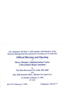
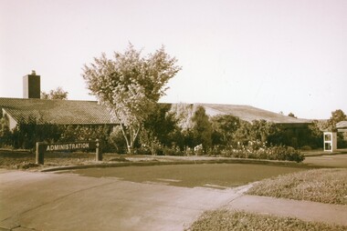
Ephemera - Mercy Hospice opening, 1996
... Invitation card for the opening of Mercy Hospice administration centre 11 February 1996...Hospital Invitation card for the opening of Mercy Hospice administration centre 11 February 1996 Mercy Hospice opening Ephemera Mercy Hospice opening ...Invitation card for the opening of Mercy Hospice administration centre 11 February 1996hospital -
 Department of Health and Human Services
Photograph, Colanda Grounds - Exterior of Administration with telephone box
... Digitised colour photograph of the exterior of the Colanda Centre Administration and telephone box....Department of Health and Human Services 50 Lonsdale St Melbourne melbourne The Colac, Victoria-based Colanda Centre was one of the last Victorian institutions and offered disability accommodation from 1976, when it was established, until 2019, with its closure. colanda, colac, disability services, residential services, disability, digitised photograph Digitised colour photograph of the exterior of the Colanda Centre Administration and telephone box. Colanda Grounds - Exterior of Administration with telephone box Photograph ...The Colac, Victoria-based Colanda Centre was one of the last Victorian institutions and offered disability accommodation from 1976, when it was established, until 2019, with its closure.Digitised colour photograph of the exterior of the Colanda Centre Administration and telephone box.colanda, colac, disability services, residential services, disability, digitised photograph -
 City of Greater Bendigo - Civic Collection
Photograph - Strathfieldsaye Councillor Group Portrait, D.G. Coope & Son - Framers
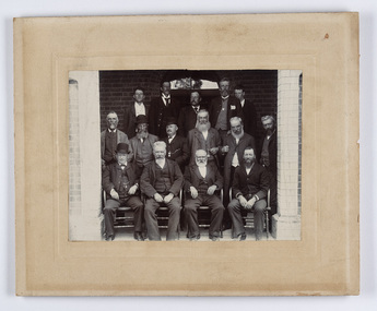
... The shire's administration centre was in Strathfieldsaye until 1972 when new offices were opened in Kennington....The shire's administration centre was in Strathfieldsaye until 1972 when new offices were opened in Kennington. ...The district of Strathfieldsaye was proclaimed in 1861 and named a Shire on the 17th September in 1866. It remained a shire until amalgamation in 1994 when it became part of the City of Greater Bendigo. The shire was located 8 km to the south- east of Bendigo and covered an area of 601 square kilometres and extended from the Calder Highway to the Coliban and Campaspe Rivers. The shire's administration centre was in Strathfieldsaye until 1972 when new offices were opened in Kennington.Silver gelatin framed photographic group portrait of fifteen men taken in the alcove of the Strathfieldsaye Shire Hall. Four men are seated and eleven are standing. Photograph is attached directly to cream mount card. Handwritten note with photograph: 1/ John Burke, 2/ (?), 3/ (?), 4/ RHS Abbott, 5/ M Brennan, 6/(?) 7/(?) 1/. M Condon? 2/ (?) 3/ M Burns, 4/(?) Gentlemen at back are probably council staff.shire of strathfieldsaye, strathfieldsaye shire council, president of strathfieldsaye shire, councillor john burke, councillor r.h.s. abbott, councillor brennan, councillor condon, councillor m burns -
 City of Greater Bendigo - Civic Collection
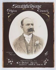
Photograph - Portrait of Councillor Keck, W H Robinson, c 1913
... The shire's administration centre was in Strathfieldsaye until 1972 when new offices were opened in Kennington....The shire's administration centre was in Strathfieldsaye until 1972 when new offices were opened in Kennington. ...The district of Strathfieldsaye was proclaimed in 1861 and named a Shire on the 17th September in 1866. It remained a shire until amalgamation in 1994 when it became part of the City of Greater Bendigo. The shire was located 8 km to the south- east of Bendigo and covered an area of 601 square kilometres and extended from the Calder Highway to the Coliban and Campaspe Rivers. The shire's administration centre was in Strathfieldsaye until 1972 when new offices were opened in Kennington.Framed black and white head and shoulder portrait of Councillor Keck with hand coloured and drawn detail. Profile slightly to right with walrus moustache. Cut oval brown mount decorated with text and flowers. Hand written title top and lower centre.Strathfieldsaye / Shire Council / W.H. Robinson / Photo / Bendigo / J.H.E Gribbs / Presented by / Cr Herbert Keck / President 1903-4. 1912-13.shire of strathfieldsaye, councillor keck, strathfieldsaye shire council, president of strathfieldsaye shire -
 City of Greater Bendigo - Civic Collection
Photograph - Portrait of Councillor Burke
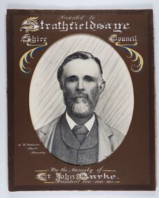
... The shire's administration centre was in Strathfieldsaye until 1972 when new offices were opened in Kennington. ...The shire's administration centre was in Strathfieldsaye until 1972 when new offices were opened in Kennington. ...The district of Strathfieldsaye was proclaimed in 1861 and named a Shire on the 17th September in 1866. It remained a shire until amalgamation in 1994 when it became part of the City of Greater Bendigo. The shire was located 8 km to the south- east of Bendigo and covered an area of 601 square kilometres and extended from the Calder Highway to the Coliban and Campaspe Rivers. The shire's administration centre was in Strathfieldsaye until 1972 when new offices were opened in Kennington. Framed black and white head and shoulder portrait of Councillor Burke with hand coloured and drawn detail. Profile centre facing with beard. Cut oval brown mount decorated with text and fscrolls. Hand written title top and lower centre. Wooden frame with detail and gold inner.Presented to Strathfieldsaye / shire Council / w. H. robinson / Photo / Bendigo / By the family of / Cr John Burke / President 1890 - 1899 - 1900strathfieldsaye shire council, councillor burke, president of strathfieldsaye shire -
 City of Greater Bendigo - Civic Collection
Photograph - Portrait of Councillor Thomas Somerville, W H Robinson
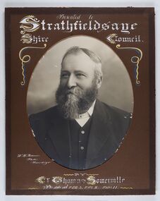
... The shire's administration centre was in Strathfieldsaye until 1972 when new offices were opened in Kennington...The shire's administration centre was in Strathfieldsaye until 1972 when new offices were opened in Kennington Strathfieldsaye Shire Council Councillor Somerville President of Strathfieldsaye Shire Presented to / Strathfieldsaye / Shire Council / W. ...The district of Strathfieldsaye was proclaimed in 1861 and named a Shire on the 17th September in 1866. It remained a shire until amalgamation in 1994 when it became part of the City of Greater Bendigo. The shire was located 8 km to the south- east of Bendigo and covered an area of 601 square kilometres and extended from the Calder Highway to the Coliban and Campaspe Rivers. The shire's administration centre was in Strathfieldsaye until 1972 when new offices were opened in KenningtonFramed black and white head and shoulder portrait of Councillor Somerville with hand drawn detail. Profile slightly to left, face has full beard. Cut oval brown mount decorated with text and scrolls. Hand written title top and lower centre.Presented to / Strathfieldsaye / Shire Council / W. H. Robinson / Photo / Bendigo / by / Cr Thomas Somerville / President 1892 - 3. 1901.2. 1910.11 strathfieldsaye shire council, councillor somerville, president of strathfieldsaye shire -
 City of Greater Bendigo - Civic Collection
Photograph - Portrait of Councillor Michael Condon, W H Robinson
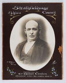
... The shire's administration centre was in Strathfieldsaye until 1972 when new offices were opened in Kennington...The shire's administration centre was in Strathfieldsaye until 1972 when new offices were opened in Kennington Strathfieldsaye Shire Council President of Strathfieldsaye Shire Councillor Condon Strathfieldsaye / Shire / Council / W. ...The district of Strathfieldsaye was proclaimed in 1861 and named a Shire on the 17th September in 1866. It remained a shire until amalgamation in 1994 when it became part of the City of Greater Bendigo. The shire was located 8 km to the south- east of Bendigo and covered an area of 601 square kilometres and extended from the Calder Highway to the Coliban and Campaspe Rivers. The shire's administration centre was in Strathfieldsaye until 1972 when new offices were opened in KenningtonFramed black and white head and shoulder portrait of Councillor Condon with hand coloured and drawn detail. Profile slightly to left. No facial hair. Cut oval brown mount decorated with text, scrolls and flowers. Hand written title top and lower centre.Strathfieldsaye / Shire / Council / W. H. Robinson / Photo / Bendigo / JMB Gribble / Presented by / Cr Michael Condon / President 1889 - 90. 1895-6. 1904 - 5strathfieldsaye shire council, president of strathfieldsaye shire, councillor condon -
 City of Greater Bendigo - Civic Collection
Photograph - Portrait of Councillor Doak, W H Robinson
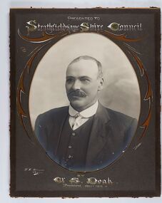
... The shire's administration centre was in Strathfieldsaye until 1972 when new offices were opened in Kennington....The shire's administration centre was in Strathfieldsaye until 1972 when new offices were opened in Kennington. ...The district of Strathfieldsaye was proclaimed in 1861 and named a Shire on the 17th September in 1866. It remained a shire until amalgamation in 1994 when it became part of the City of Greater Bendigo. The shire was located 8 km to the south- east of Bendigo and covered an area of 601 square kilometres and extended from the Calder Highway to the Coliban and Campaspe Rivers. The shire's administration centre was in Strathfieldsaye until 1972 when new offices were opened in Kennington.Framed black and white head and shoulder portrait of Councillor Doak with hand coloured and drawn detail. Left facing profile with walrus moustache. Cut oval brown mount decorated with text and scrolls. Hand written title top and lower centre.Presented to / Strathfieldsaye Shire Council / W. H. Robinson / Photo / JMB Gribble / by Cr S. Doak / President 1911 - 1912strathfieldsaye shire council, president of strathfieldsaye shire, councillor doak -
 City of Greater Bendigo - Civic Collection
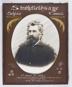
Photograph - Portrait of Councillor Sibley, W H Robinson
... The shire's administration centre was in Strathfieldsaye until 1972 when new offices were opened in Kennington...The shire's administration centre was in Strathfieldsaye until 1972 when new offices were opened in Kennington Strathfieldsaye Shire Council Councillor Sibley President of Strathfieldsaye Shire Strathfieldsaye / Shire Council / W m Robinson / Photo / Bendigo / J N B Gribble / Cr Robert R Sibley / First President Chairman of the Road Board 1865 - 5 / President 1866 - 1869 / With Mrs Sibley's Compliments Framed black and white head and shoulder portrait of Councillor Sibley with hand coloured and drawn detail. ...The district of Strathfieldsaye was proclaimed in 1861 and named a Shire on the 17th September in 1866. It remained a shire until amalgamation in 1994 when it became part of the City of Greater Bendigo. The shire was located 8 km to the south- east of Bendigo and covered an area of 601 square kilometres and extended from the Calder Highway to the Coliban and Campaspe Rivers. The shire's administration centre was in Strathfieldsaye until 1972 when new offices were opened in KenningtonFramed black and white head and shoulder portrait of Councillor Sibley with hand coloured and drawn detail. Profile slightly to left with walrus moustache and beard. Cut oval brown mount decorated with text, flowers and scrolls. Hand written title top and lower centre.Strathfieldsaye / Shire Council / W m Robinson / Photo / Bendigo / J N B Gribble / Cr Robert R Sibley / First President Chairman of the Road Board 1865 - 5 / President 1866 - 1869 / With Mrs Sibley's Complimentsstrathfieldsaye shire council, councillor sibley, president of strathfieldsaye shire -
 City of Greater Bendigo - Civic Collection
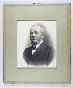
Photograph - Portrait of Councillor Long, Talma & Co
... The shire's administration centre was in Strathfieldsaye until 1972 when new offices were opened in Kennington....The shire's administration centre was in Strathfieldsaye until 1972 when new offices were opened in Kennington. ...The district of Strathfieldsaye was proclaimed in 1861 and named a Shire on the 17th September in 1866. It remained a shire until amalgamation in 1994 when it became part of the City of Greater Bendigo. The shire was located 8 km to the south- east of Bendigo and covered an area of 601 square kilometres and extended from the Calder Highway to the Coliban and Campaspe Rivers. The shire's administration centre was in Strathfieldsaye until 1972 when new offices were opened in Kennington.Framed black and white head and shoulder portrait of Councillor Long. Profile to left with walrus moustache and mutton chops. Cut olive retangle mount. Verso; Long. On under board which has photograph attached; Talma & Co. / 119 Swanston St., / Melbournestrathfieldsaye shire council, councillor long -
 City of Greater Bendigo - Civic Collection
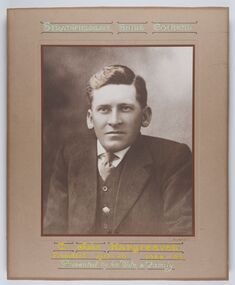
Photograph - Portrait of Councillor Hargraves, Bartlett Bros
... The shire's administration centre was in Strathfieldsaye until 1972 when new offices were opened in Kennington...The shire's administration centre was in Strathfieldsaye until 1972 when new offices were opened in Kennington Strathfieldsaye Shire Council President of Strathfieldsaye Shire Councillor Hargreaves Strathfiledsaye Shire Council / Cr John Hargreaves / President 1919 - 20 1928 - 29 / Presented by his Wife & Family Framed black and white head and shoulder portrait of Councillor Hargraves. ...The district of Strathfieldsaye was proclaimed in 1861 and named a Shire on the 17th September in 1866. It remained a shire until amalgamation in 1994 when it became part of the City of Greater Bendigo. The shire was located 8 km to the south- east of Bendigo and covered an area of 601 square kilometres and extended from the Calder Highway to the Coliban and Campaspe Rivers. The shire's administration centre was in Strathfieldsaye until 1972 when new offices were opened in KenningtonFramed black and white head and shoulder portrait of Councillor Hargraves. Profile slightly to right with walrus moustache. Cut rectangle brown mount decorated with coloured text and scrolls. Hand written title top and lower centre.Strathfiledsaye Shire Council / Cr John Hargreaves / President 1919 - 20 1928 - 29 / Presented by his Wife & Familystrathfieldsaye shire council, president of strathfieldsaye shire, councillor hargreaves -
 City of Greater Bendigo - Civic Collection
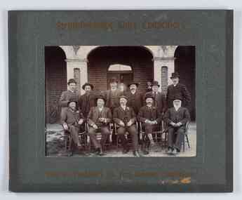
Photograph - Councillor group portrait, W H Robinson, Strathfieldsaye Shire Council, 1909
... The shire's administration centre was in Strathfieldsaye until 1972 when new offices were opened in Kennington....The shire's administration centre was in Strathfieldsaye until 1972 when new offices were opened in Kennington. ...The district of Strathfieldsaye was proclaimed in 1861 and named a Shire on the 17th September in 1866. It remained a shire until amalgamation in 1994 when it became part of the City of Greater Bendigo. The shire was located 8 km to the south- east of Bendigo and covered an area of 601 square kilometres and extended from the Calder Highway to the Coliban and Campaspe Rivers. The shire's administration centre was in Strathfieldsaye until 1972 when new offices were opened in Kennington.Photographic group portrait of eleven Strathfieldsaye Shire Councillors in front of the Strathfieldsaye Shire Hall. Five men are seated and six standing with one man standing further in back ground on the building's verandah. Photograph is attached directly to green mount card and framed. Gold lettering on mount.Strathfieldsaye Shire Councillors / R. B. Brennan (Sec.) W. J. Lowdes S. Doak M. Burns () N Condon B. Code (Inspector) / WH Robinson Photo Bendigo / T Somerville / W. I. Long / Fred Osborne (President) H Keck / W Dresler / With the President's (Cr. Fred Osborne) Compliments / September 23rd, 1909shire of strathfieldsaye, strathfieldsaye shire council, president of strathfieldsaye shire, strathfieldsaye shire hall -
 City of Greater Bendigo - Civic Collection
Photograph - Councillor group portrait, W H Robinson, Strathfieldsaye Shire Council
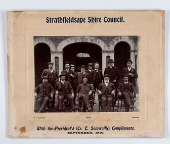
... The shire's administration centre was in Strathfieldsaye until 1972 when new offices were opened in Kennington. ...The shire's administration centre was in Strathfieldsaye until 1972 when new offices were opened in Kennington. ...The district of Strathfieldsaye was proclaimed in 1861 and named a Shire on the 17th September in 1866. It remained a shire until amalgamation in 1994 when it became part of the City of Greater Bendigo. The shire was located 8 km to the south- east of Bendigo and covered an area of 601 square kilometres and extended from the Calder Highway to the Coliban and Campaspe Rivers. The shire's administration centre was in Strathfieldsaye until 1972 when new offices were opened in Kennington. Group portrait of 13 men / councilors, 5 seated and 8 standing dressed in suits. There are another 2 men further back in front of the hall doors. Photograph is taken outside the Strathfieldsaye Shire Hall.Srathfieldsaye Shire Council. / With the President's (Cr T. Somerville) Compliments. / September, 1910 / W.H. Robinson Photo. Bendigo Verso; William Drechslershire of strathfieldsaye, president of strathfieldsaye shire, strathfieldsaye shire council -
 City of Greater Bendigo - Civic Collection
Sign - Shire of Strathfieldsaye Coat of Arms
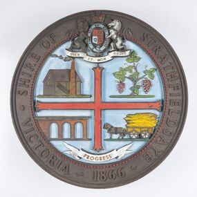
... The shire's administration centre was in Strathfieldsaye until 1972 when new offices were opened in Kennington. ...The shire's administration centre was in Strathfieldsaye until 1972 when new offices were opened in Kennington. ...The district of Strathfieldsaye was proclaimed in 1861 and named a Shire on the 17th September in 1866. It remained a shire until amalgamation in 1994 when it became part of the City of Greater Bendigo. The shire was located 8 km to the south- east of Bendigo and covered an area of 601 square kilometres and extended from the Calder Highway to the Coliban and Campaspe Rivers. The shire's administration centre was in Strathfieldsaye until 1972 when new offices were opened in Kennington. This coat of arms was commissioned for the front of the shire hall building.Brass painted coat of arms or emblem within a circle of the Shire of Strathfieldsaye. Outer rim contains text: SHIRE OF STRATHFIELDSAYE VICTORIA 1866 with the shield of the monarch of the United Kingdom centre top. The shield is divided into four parts with images reflecting the leading industries of the time; wine growing, mining, farming and tanning. The motto PROGRESS is depicted lower centre of shield. SHIRE OF STRATHFIELDSAYE / VICTORIA / 1866 / PROGRESSshire of strathfieldsaye, city of greater bendigo amalgamation, city of greater bendigo signs -
 Federation University Historical Collection
Photograph, Building D Mount Helen Campus, by Lucie Akers, 2023
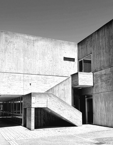
... Currently (2024) inhabits university administration, AEC Centre, Disability Services, and VC Offices. ...Currently (2024) inhabits university administration, AEC Centre, Disability Services, and VC Offices. ...Building D at Mount Helen Campus, Federation University. Currently (2024) inhabits university administration, AEC Centre, Disability Services, and VC Offices. This building was designed by architect Ewan Jones. Building D Mount Helen Campus, by Lucie Akers, 2023brutalism, federation university australia, mount helen campus, architect, education, building d, ewan jones and associates -
 City of Greater Bendigo - Civic Collection
Photograph - Portrait of Councillor Orr, The Yeoman Studios, Ex. Councillor / F. Orr / Eppalock
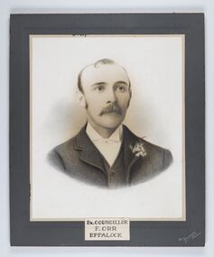
... The shire's administration centre was in Strathfieldsaye until 1972 when new offices were opened in Kennington. ...The shire's administration centre was in Strathfieldsaye until 1972 when new offices were opened in Kennington. ...The district of Strathfieldsaye was proclaimed in 1861 and named a Shire on the 17th September in 1866. It remained a shire until amalgamation in 1994 when it became part of the City of Greater Bendigo. The shire was located 8 km to the south- east of Bendigo and covered an area of 601 square kilometres and extended from the Calder Highway to the Coliban and Campaspe Rivers. The shire's administration centre was in Strathfieldsaye until 1972 when new offices were opened in Kennington. Eppalock Ward is one of three wards in the Greater Bendigo municipality which includes the former Strathfieldsaye Shire. Framed black and white head and shoulder portrait with hand coloured detail. Man with profile slightly to right, walrus moustache, image encircled. Photograph is attached to mount card. Hand written title lower centre.Ex. Councillor / F. Orr / Eppalock / The / Yeoman / Studiosshire of strathfieldsaye, councillor orr -
 City of Greater Bendigo - Civic Collection
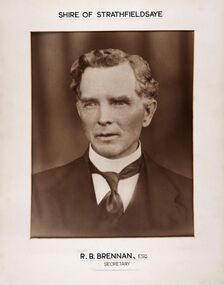
Photograph - Portrait of Shire Secretary Brennan, Unknown
... The shire's administration centre was in Strathfieldsaye until 1972 when new offices were opened in Kennington. ...The shire's administration centre was in Strathfieldsaye until 1972 when new offices were opened in Kennington. ...The district of Strathfieldsaye was proclaimed in 1861 and named a Shire on the 17th September in 1866. It remained a shire until amalgamation in 1994 when it became part of the City of Greater Bendigo. The Shire was located 8 km to the south- east of Bendigo and covered an area of 601 square kilometres and extended from the Calder Highway to the Coliban and Campaspe Rivers. The shire's administration centre was in Strathfieldsaye until 1972 when new offices were opened in Kennington. Secretary Brennan, son of Councillor M. Brennan was appointed after his fathers death to the role and according to the The Bendigo Independent was in the role in 1917. See References.Framed black and white head and shoulder portrait of Councillor Brennan. Profile slightly to left. Cut rectangle cream mount. Hand written title top and lower centre. Shire of Strathfieldsaye / R. B. Brennan, Esq / Secretarystrathfieldsaye shire council, secretary strathfieldsaye shire -
 City of Greater Bendigo - Civic Collection
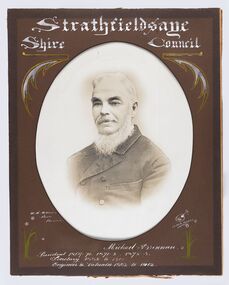
Photograph - Portrait of Councillor Brennan, W H Robinson
... The shire's administration centre was in Strathfieldsaye until 1972 when new offices were opened in Kennington. ...The shire's administration centre was in Strathfieldsaye until 1972 when new offices were opened in Kennington. ...The district of Strathfieldsaye was proclaimed in 1861 and named a Shire on the 17th September in 1866. It remained a shire until amalgamation in 1994 when it became part of the City of Greater Bendigo. The shire was located 8 km to the south- east of Bendigo and covered an area of 601 square kilometres and extended from the Calder Highway to the Coliban and Campaspe Rivers. The shire's administration centre was in Strathfieldsaye until 1972 when new offices were opened in Kennington. Councillor Michael Brennan held roles of Shire Secretary and Clark of Works until around 1998 when his son R. B. Brennan was appointed Assistant Secretary and then Shire Secretary to assist his father with the work load during his later years. Michael Brennan remained Clerk of Works until his death at which time his son was appointed to the duties previously held by his father. Framed black and white head and shoulder portrait of Councillor Brennan with hand coloured and drawn detail. Profile to left. Cut oval brown mount decorated with text and flowers. Hand written title top and lower centreStrathfieldsaye / Shire Council / W H Robinson / Photo / Bendigo / J H B Gribble / Michael Brennan / President 1869 - 70. 1871 - 2. 1872 - 3 / Secretary 1882 to 1900 / Engineer & Valuator 1882 to 1902strathfieldsaye shire council, councillor brennan, president of strathfieldsaye shire -
 University of Melbourne, Burnley Campus Archives
Album - Colour prints, Photograph Album Burnley College Buildings, 1981-1985
... Most stamped 20 Aug 1985 on reverse, Quad construction 1981.(1) Administration Building front entrance. (2) Administration Building front view. (3) Administration Building front centre. (4) Administration Building, back entrance, Hall end. (5) Administration Building, back centre. (6, 7) Student Amenities Building. (8) Quad 5. (9, 10) Library, front completed 1982. (10A) Library, back. (11) Nursery. (12) Nursery (13,14) Quads 2,3,4. (15) Quad 6 back. (16) Engineering (17) Library front from the Bull Paddock. (18) Dairy. (19) Principal's Garage, now Herb Garden. (20) Soil Bins old Nursery. (21) Old Nursery. (22) Greenhouse old Nursery. (23-25) Landscape Shed. (26) Orchard Shed. (27) Orchard Shed and Kiwi Fruit vine. (28,29) Plant Science Laboratory. (30) Energy Efficient Glasshouse old Nursery. (31) Glasshouse old Nursery and Potting Shed. (32) Energy Efficient Greenhouse old Nursery. (33) Potting Shed old Nursery....Most stamped 20 Aug 1985 on reverse, Quad construction 1981.(1) Administration Building front entrance. (2) Administration Building front view. (3) Administration Building front centre. (4) Administration Building, back entrance, Hall end. (5) Administration Building, back centre. (6, 7) Student Amenities Building. (8) Quad 5. (9, 10) Library, front completed 1982. (10A) Library, back. (11) Nursery. (12) Nursery (13,14) Quads 2,3,4. (15) Quad 6 back. (16) Engineering (17) Library front from the Bull Paddock. (18) Dairy. (19) Principal's Garage, now Herb Garden. (20) Soil Bins old Nursery. (21) Old Nursery. (22) Greenhouse old Nursery. (23-25) Landscape Shed. (26) Orchard Shed. (27) Orchard Shed and Kiwi Fruit vine. (28,29) Plant Science Laboratory. (30) Energy Efficient Glasshouse old Nursery. (31) Glasshouse old Nursery and Potting Shed. (32) Energy Efficient Greenhouse old Nursery. (33) Potting Shed old Nursery. ...Collection of 34 photographs in a cardboard photograph album with plastic pages. Most stamped 20 Aug 1985 on reverse, Quad construction 1981.(1) Administration Building front entrance. (2) Administration Building front view. (3) Administration Building front centre. (4) Administration Building, back entrance, Hall end. (5) Administration Building, back centre. (6, 7) Student Amenities Building. (8) Quad 5. (9, 10) Library, front completed 1982. (10A) Library, back. (11) Nursery. (12) Nursery (13,14) Quads 2,3,4. (15) Quad 6 back. (16) Engineering (17) Library front from the Bull Paddock. (18) Dairy. (19) Principal's Garage, now Herb Garden. (20) Soil Bins old Nursery. (21) Old Nursery. (22) Greenhouse old Nursery. (23-25) Landscape Shed. (26) Orchard Shed. (27) Orchard Shed and Kiwi Fruit vine. (28,29) Plant Science Laboratory. (30) Energy Efficient Glasshouse old Nursery. (31) Glasshouse old Nursery and Potting Shed. (32) Energy Efficient Greenhouse old Nursery. (33) Potting Shed old Nursery.quad construction, administration building, student amenities, library, nursery, bull paddock, dairy, principal's garage, herb garden, soil bins, greenhouse, landscape shed, orchard shed, kiwi fruit vine, plant science laboratory, energy efficient glasshouse, potting shed -
 City of Greater Bendigo - Civic Collection
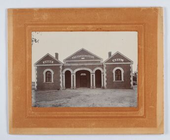
Photograph - Strathfieldsaye Shire Hall
... The shire's administration activities were centred at the Strathfieldsaye Shire Hall which was built in 1869 at a cost of £700 based on a design by George Steane, the shire surveyor and built by George Pallett of Sandhurst. ...The shire's administration activities were centred at the Strathfieldsaye Shire Hall which was built in 1869 at a cost of £700 based on a design by George Steane, the shire surveyor and built by George Pallett of Sandhurst. ...The district of Strathfieldsaye was proclaimed in 1861 and named a Shire on the 17th September in 1866. It remained a shire until amalgamation in 1994 when it became part of the City of Greater Bendigo. The shire was located 8 km to the south- east of Bendigo and covered an area of 601 square kilometres and extended from the Calder Highway to the Coliban and Campaspe Rivers. The shire's administration activities were centred at the Strathfieldsaye Shire Hall which was built in 1869 at a cost of £700 based on a design by George Steane, the shire surveyor and built by George Pallett of Sandhurst. Constructed of red brick, the hall has a unique ventilation system with hollow walls open at the top and bottom to ensure a draught to cool the building in summer. Framed and mounted photograph of the Strathfieldsaye Shire Hall. Verso; W M Robinson / Photographer / Mundy Street Bendigostrathfieldsaye shire hall, shire of strathfieldsaye, strathfieldsaye shire council -
 Federation University Historical Collection
Photograph - Photographs - black and white, Ballarat School of Mines: Lydiard Street Campus Buildings, early 1900s, c1978
... Also Administration building including the teaching and other spaces. .2: "Old Chemistry building" showing the south side and west end. .3: Art school on the left, Ballarat Brewery boiler chimney stack in centre background, Administration building on the right. .4: Entrance on the north side of Art School building .5: South side entrance of Administration building....Also Administration building including the teaching and other spaces. .2: "Old Chemistry building" showing the south side and west end. .3: Art school on the left, Ballarat Brewery boiler chimney stack in centre background, Administration building on the right. .4: Entrance on the north side of Art School building .5: South side entrance of Administration building. ...These photographs were taken just before structural modifications and connecting overhead walkways were commenced in 1978.1: Art School opened in 1915 on the site of the original SMB building.It was converted from the abandoned court house. Also Administration building including the teaching and other spaces. .2: "Old Chemistry building" showing the south side and west end. .3: Art school on the left, Ballarat Brewery boiler chimney stack in centre background, Administration building on the right. .4: Entrance on the north side of Art School building .5: South side entrance of Administration building.ballarat school of mines, buildings, a building, administration building, lydiard street south, smb campus -
 Federation University Historical Collection
Photograph - Photograph and Documents, Anne Beggs Sunter, Latta/Downing Family, Mount Helen
... The house was situated in the vicinity of the current Administration and Caro Conference Centre buildings, surrounded by an orchard, and a well under the current Albert Coates Building (Union Building). ...The house was situated in the vicinity of the current Administration and Caro Conference Centre buildings, surrounded by an orchard, and a well under the current Albert Coates Building (Union Building). ...The Federation University Mt Helen Campus was once the farm of John Latta and his wife Elizabeth Ann Dean. The couple married in 1867 and had three children at the time of John Latta's death (Elizabeth Ann b.1870; Mary b.1873; John b.1875). Elizabeth later married George Downing, and had another six children. The house was situated in the vicinity of the current Administration and Caro Conference Centre buildings, surrounded by an orchard, and a well under the current Albert Coates Building (Union Building). The land was purchased by the Ballarat School of Mines for their tertiary division from the Stapleton family.Various items relating to the Federation University Mount Helen Campus, and the early settlers on the land, the Latta Family. .1) Parish Plan, including E. Latta, M. Fiscalini, R. Wynne, R. Nixon, J.U. Smith, J. Davis .2) Part of a 1930s ordinance map showing Ballarat, Buninyong and Greenhill .3) Contour Map with the first two Mt Helen Campus buildings included. .4) Drawing a a proposed campus plan .5) Latta Family negativemount helen campus, latta family, greenhill, e. latta, m. fiscalini, r. wynne, r. nixon, j.u. smith, j. davis, parish plan, john latta, elizabeth latta, george downing, elezabeth downing, green hill, pontresina, abraham baxter, g. dean, market gardens, jim downing, bob thornton, j. hateley, martin fanning, toll keeper, anne beggs sunter -
 Federation University Historical Collection
Photograph - black and white, Mr Downing by the Federation University Tree of Knowledge, 1970
... centre Mount Helen Campus concept plan, and later became known as the Tree of Knowledge. Mr Dowling watered the tree after it was planted by his mother, Elizabeth Downing, on Arbour Day 1896. Mrs Downing raised her large family on the site of the Mount Helen Campus, which included an orchard and milking cows. The Tree of Knowledge is actually two trees, the trunks have fused together over time, and there is further evidence of fusion. The Downing farmhouse was situated in the vicinity of the present Administration...centre Mount Helen Campus concept plan, and later became known as the Tree of Knowledge. Mr Dowling watered the tree after it was planted by his mother, Elizabeth Downing, on Arbour Day 1896. Mrs Downing raised her large family on the site of the Mount Helen Campus, which included an orchard and milking cows. The Tree of Knowledge is actually two trees, the trunks have fused together over time, and there is further evidence of fusion. The Downing farmhouse was situated in the vicinity of the present Administration ...Federation University Mount Helen Campus was open to students in 1970. In that year Mr Dowling as photographed beside a big Tasmanian bluegum which was used a the centre Mount Helen Campus concept plan, and later became known as the Tree of Knowledge. Mr Dowling watered the tree after it was planted by his mother, Elizabeth Downing, on Arbour Day 1896. Mrs Downing raised her large family on the site of the Mount Helen Campus, which included an orchard and milking cows. The Tree of Knowledge is actually two trees, the trunks have fused together over time, and there is further evidence of fusion. The Downing farmhouse was situated in the vicinity of the present Administration and Caro Conference Centre buildings and the tree was planted beside the "dunny". It was carefully watered by the nine Downing children from a brick-lined well situated under what is now the Albert Coates Building. As the tree grew to maturity, it was used to hang a meat safe after slaughtering a sheep for the family table. Some years ago, when the foundations were being dug for the E-Building, an old rusted percussion pistol was found. One of Mrs Downing's sons, at that time well into his nineties, remembered getting into trouble for playing with it without permission, and losing it. The land was purchased in 1966 as part of a 241-acre site for Ballarat's new tertiary institution. When the architects and planners inspected the site, they decided "The Big Tree" must remain as a central landmark in preparing the layout of the campus amenities. In 1982, the spread of the tree was 36 metres, girth 7 metres, and height 36 metres. By 2003 the spread was 39.5 metres (N-S) and 35.5 metres (E-W), girth 7.75 metres, and height 42.5 metres. A man in overalls and jacket stands beside the Federation University Tree of Knowledge. Stage one buildings on the Mount Helen Campus are evident in the background.elizabeth downing, downing, tree of knowledge, big tree, mount helen campus, mount helen -
 Bendigo Military Museum
Photograph - Army Survey Regiment – Corps Day Parade, Fortuna Villa, Bendigo, 1995
... WO2 Gill Park. In centre - Administration Support Squadron. On right - Data Acquisition Squadron. 7.) - Photo, colour, 1995. ...WO2 Gill Park. In centre - Administration Support Squadron. On right - Data Acquisition Squadron. 7.) - Photo, colour, 1995. ...This set of 23 photographs were taken at the Corps Day Parade held at the Army Survey Regiment, Bendigo on the 1st of July 1995. This occasion was to commemorate the 80th anniversary of the formation of the Royal Australian Survey Corps. The Parade Commander was CO LTCOL Duncan Burns, and the Reviewing Officer was the Deputy Chief of the Defence Force MAJGEN G.D. Carter AM. Also in attendance was his MA MAJ M.D. Bornholt AM and the COL COMDT of the Royal Australian Survey Corps COL Don Swiney MBE. On this occasion the Reviewing Officer presented the Defence Force Service Medal to SGT Graham Hales and SPR Ken Labouchardiere for 15 years of efficient remunerated service in the Australian Army. SSGT Russ Mollenhauer received the Defence Force Service Medal clasp in recognition of 20 years of service. SGT Stuart Symonds received his second Defence Force Service Medal clasp in recognition of 25 years of service.This is a set of 23 photographs of the Corps Day Parade held at the Army Survey Regiment, Fortuna, Bendigo on the 1st July 1995. The colour photographs were printed on photographic paper and are part of the Army Survey Regiment’s Collection. The photographs were scanned at 300 dpi. .1) - Photo, colour, 1995. Fortuna Pipes and Drums lead the Army Survey Regiment onto the parade ground. .2) to .3) - Photo, colour, 1995. Fortuna Pipes and Drums in position on the parade ground. .4) - Photo, colour, 1995. Data Acquisition Squadron marches onto the parade ground, led by L to R: WO2 Peter Imeson, WO2 Bruce Hammond. .5) - Photo, colour, 1995. Data Acquisition Squadron front rank L to R: WO2 Peter Imeson, SPR Stuart Catharall, CPL Damien Killeen, CPL Trevor King, SPR Glen Norrell, SPR Kim Baker, SPR Craig Smith, LCPL Mark Fedden, SGT Graham Hales, SPR Josh Andrews OAM, unidentified (x2), WO2 Bruce Hammond. .6) - Photo, colour, 1995. Army Survey Regiment in position on the parade ground. On left - Product Construction Squadron rear rank L to R: CPL Dave Scott, SPR Shane Campbell, CPL Guenther Ebenwaldner, remainder unidentified. Centre rank L to R: CPL Ian Bowes, remainder unidentified. RSM WO1 Ken Johnston OAM MM. Front rank L to R: WO2 Alan Virtue, SSGT Bob Thrower, CPL Paul Einam, SGT Peter Tuddenham, SPR Dik Brierley, SGT Stuart Ridge, SPR Mick Muzeen, SPR Marty Stradbrook, unidentified, SGT Steve Nokes, SPR James Commons, SPR Lance Hillier. WO2 Gill Park. In centre - Administration Support Squadron. On right - Data Acquisition Squadron. 7.) - Photo, colour, 1995. Officers ready to take posts. L to R: LT Dave Sapparth, CAPT Colin Davidson, CAPT Tony Harder – UK Exchange Officer, LT Jason Selman, CAPT Doug Arman, QM CAPT Bill Griggs, LT Roger Grose, CAPT Bin Fashar Sutimin – Indonesian Exchange Officer in white uniform, MAJ Ross Jenkins, CAPT Gary Warnest. 8.) - Photo, colour, 1995. CO LTCOL Duncan Burns salutes the Reviewing Officer MAJGEN G.D. Carter AM. .9) & .10) - Photo, colour, 1995. Data Acquisition Squadron presents arms. Officers’ rank L to R: CAPT Tony Harder – UK Exchange Officer, CAPT Colin Davidson, LT Dave Sapparth. ADJT CAPT Brenton McDonald at far right. Front rank L to R: WO2 Peter Imeson, SPR Stuart Catharall, CPL Damien Killeen, CPL Trevor King, SPR Glen Norrell, SPR Kim Baker, SPR Craig Smith, LCPL Mark Fedden, SGT Graham Hales, SPR Josh Andrews OAM, unidentified (x2), WO2 Bruce Hammond. 11) - Photo, colour, 1995. Army Survey Regiment presenting arms. L to R: Product Construction Squadron, Administration Support Squadron, Data Acquisition Squadron. .12) - Photo, colour, 1995. Product Construction Squadron presents arms. Officers’ Rank: 2IC MAJ Mick Banham, L to R: CAPT Gary Warnest, OC MAJ Ross Jenkins CAPT Bin Fashar Sutimin – Indonesian Exchange Officer, LT Roger Grose. L to R: RSM WO1 Ken Johnston OAM MM. Front rank L to R: SSGT Bob Thrower, CPL Paul Einam, SGT Peter Tuddenham, SPR Dik Brierley, SGT Stuart Ridge, SPR Mick Muzeen, SPR Marty Stradbrook, unidentified, SGT Steve Nokes, SPR James Commons, SPR Lance Hillier, WO2 Gill Park. Other identifiable personnel in rear ranks L to R: SGT Peter Tuddenham, SPR Ben Lucas, SPR Dik Brierley, SGT Dale Hudson, SPR Annette (Odgers) Wynn, CPL Roger Pearson, SPR Corey Hill, SSGT Russ Mollenhauer. 13) - Photo, colour, 1995. Army Survey Regiment Advances in Review Order. L to R: Product Construction Squadron, Administration Support Squadron, Data Acquisition Squadron. 14) - Photo, colour, 1995. Army Survey Regiment in rank formation slow marches around parade ground L to R: Product Construction Squadron, Administration Support Squadron, Data Acquisition Squadron. .15) & .16) - Photo, colour, 1995. Data Acquisition Squadron slow marches, using ‘Forms’ to turn right in rank formation. Officers’ rank L to R: CAPT Tony Harder – UK Exchange Officer, CAPT Colin Davidson, LT Dave Sapparth. ADJT CAPT Brenton McDonald at far right.front rank L to R: WO2 Peter Imeson, SPR Stuart Catharall CPL Damien Killeen, CPL Trevor King, SPR Glen Norrell, SPR Kim Baker, SPR Craig Smith, LCPL Mark Fedden, SGT Graham Hales, SPR Josh Andrews OAM, unidentified (x2), WO2 Bruce Hammond. Centre Right Marker SPR Cameron Gee OAM is behind SPR Stuart Catharall. .17) - Photo, colour, 1995. Data Acquisition Squadron proceeds past Reviewing Officer on ‘Eyes Right’ command. Officers’ rank L to R: CAPT Tony Harder – UK Exchange Officer, LT Dave Sapparth. CAPT Colin Davidson. Centre Right Marker SPR Cameron Gee OAM. Right rear supernumerary SSGT Rod Skidmore, ADJT CAPT Brenton McDonald to his left. Front rank L to R: WO2 Peter Imeson, SPR Stuart Catharall CPL Damien Killeen, CPL Trevor King, SPR Glen Norrell, SPR Kim Baker, SPR Craig Smith, LCPL Mark Fedden, SGT Graham Hales, SPR Josh Andrews OAM, unidentified (x2), WO2 Bruce Hammond. CO LTCOL Duncan Burns in foreground. .18) - Photo, colour, 1995. Data Acquisition Squadron proceeds past Reviewing Officer on ‘Eyes Right’ command. Rear rank L to R: unidentified, CPL John ‘Doc’ Commons, CPL Tony Jackson, SPR Helen Scorgie. Centre rank L to R: SPR Cameron Gee OAM, SPR Derek Percival, SPR Grant Lloyd. Front rank L to R: WO2 Peter Imeson, SPR Stuart Catharall CPL Damien Killeen, CPL Trevor King, SPR Glen Norrell, SPR Kim Baker, SPR Craig Smith, LCPL Mark Fedden, SGT Graham Hales, SPR Josh Andrews OAM, unidentified (x2), WO2 Bruce Hammond. .19) - Photo, colour, 1995. L to R: MAJGEN G.D. Carter AM returning salute, MA MAJ M.D. Bornholt AM, COL COMDT, COL Don Swiney MBE, in background CPL Warren ‘Waldo’ Shirley, WO2 Pat Lumsden. 20.) - Photo, colour, 1995. Product Construction Squadron L to R: SSGT Paul ‘Hutch’ Hunter, WO2 Jeff Willey, rear rank L to R: CPL Dave Scott, SPR Shane Campbell, CPL Guenther Ebenwaldner, remainder unidentified. Centre rank L to R: CPL Ian Bowes, SPR Ben Lucas, remainder unidentified. MAJGEN G.D. Carter AM, CO LTCOL Duncan Burns, Front rank L to R: WO2 Alan Virtue, remainder unidentified, RSM WO1 Ken Johnston OAM MM, Officers’ Rank: LT Jason Selman, CAPT Bin Fashar Sutimin – Indonesian Exchange Officer, CAPT Gary Warnest, MAJ Ross Jenkins, 2IC MAJ Mick Banham. .21) - Photo, colour, 1995. L to R: Centre marker CPL Ian Bowes, SPR Ben Lucas, remainder unidentified, MAJGEN G.D. Carter AM, COL COMDT, COL Don Swiney MBE, CO LTCOL Duncan Burns, WO2 Allan Virtue. .22) & .23) - Photo, colour, 1995. L to R: WO2 Pat Lumsden, MAJGEN G.D. Carter AM, SGT Graham Hales, SPR Ken Labouchardiere, SSGT Russ Mollenhauer, SGT Stuart Symonds..1P to.23P – The occasion and date are annotated on the plastic sleeve.royal australian survey corps, rasvy, army survey regiment, army svy regt, fortuna, asr -
 Bendigo Military Museum
Photograph - PHOTOGRAPH, BENNETTS, c.1948
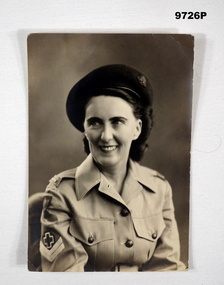
... Administration and Organizational Course and passed. transferred to LHQ Medical and Veterinary Stores. Transfers to No. 128 AGH QLD on 28.8.1944. On turning 21 she transfers to the AIF as VFX128835 on 1.9.1944 in AMC graded group 11. 12.11.1945 transfers to the Inter Services Medical Wing Demobilization Centre. ...Administration and Organizational Course and passed. transferred to LHQ Medical and Veterinary Stores. Transfers to No. 128 AGH QLD on 28.8.1944. On turning 21 she transfers to the AIF as VFX128835 on 1.9.1944 in AMC graded group 11. 12.11.1945 transfers to the Inter Services Medical Wing Demobilization Centre. promoted to the rank of Corporal on 24.9.1946. ...Alva Marie Bennetts. Alva initially enlisted as V515106 in the CMF, age 20 years on 19.2.1944 in the 4th Aust. AWS Training Battalion. From 23.3.1944 to 1.4.1944 she attended an Administration and Organizational Course and passed. transferred to LHQ Medical and Veterinary Stores. Transfers to No. 128 AGH QLD on 28.8.1944. On turning 21 she transfers to the AIF as VFX128835 on 1.9.1944 in AMC graded group 11. 12.11.1945 transfers to the Inter Services Medical Wing Demobilization Centre. promoted to the rank of Corporal on 24.9.1946. Embarks for Kure Japan with BCOF on 19.4.1947. Embarks for Australia 16.2.1949. Discharged from the Army on 13.4.19949 with the rank of Corporal in No. 130 AGH. Part of the Bennetts Collection - which also contains items of her father, William John Leslie Bennetts No.4433 1st AIF. Also her future husband Edward W Callaghan No. 147354 RAAF.Black and white photograph of a lady in uniform. She has a Corporal's rank insignia on her right sleeve below a Red Cross symbol. She is wearing a dark coloured beret with a Rising Sun badge attached. Mottled background to photograph.Handwritten on back of photograph, in black ink: 'Lots of love from Alva, Eta Jima, 18/8/48.'bennetts collection, alva bennetts, photograph, aaws, bcof -
 Kiewa Valley Historical Society
Photograph - Mount Beauty from Bogong Hill, 1950
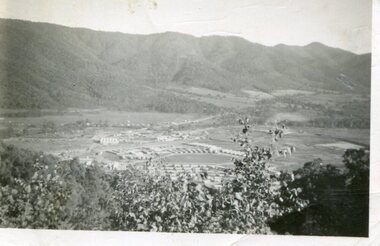
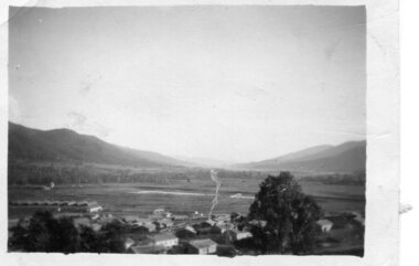
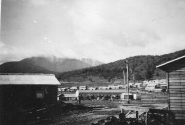
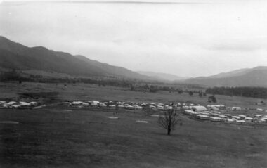
... Kiewa Valley Historical Society Mount Beauty Information Centre 31 Bogong High Plains Rd Mt Beauty high-country The new State Electricity Commission construction camp at the head of the Kiewa Valley was for workmen on the second power station in the project expected to be the most modern and best equipped in Australia… In contrast to the early Kiewa days of horses and canvas tents, the new camp, with its modern amenities, compared favourably with any country town. Administration ...The new State Electricity Commission construction camp at the head of the Kiewa Valley was for workmen on the second power station in the project expected to be the most modern and best equipped in Australia… In contrast to the early Kiewa days of horses and canvas tents, the new camp, with its modern amenities, compared favourably with any country town. Administration of the Kiewa Scheme was moved from Tawonga to Mount Beauty in 1946. The first house in Mount Beauty, in Hollonds Street, was occupied by the co-op store manager from November 1946. The new Mess Hall at Mt Beauty was opened with much ceremony in early November 1946. The houses up to Nelse street were erected from 1946 onward and then the township was extended beyond Nelse Street in 1950. The workmen's camp was enlarged in 1950 to the extent of providing accommodation for a total of 1,200.Shows early construction of the town of Mt. Beauty surrounded by farmland taken in 1950 during the early stages of construction of the Kiewa Hydro electric SystemBlack and white photograph - aerial view of Mt Beauty taken from Bogong Hill. Photograph framed by 6mm white boarder.Handwritten on back of photograph in black ink - Mt Beauty from Bogong Hill 1950 Printed on rear Volox 2428mt beauty, bogong hill, secv -
 Kiewa Valley Historical Society
Photograph - Mount Beauty from second gate. View down Kiewa Valley, 1950
... Kiewa Valley Historical Society Mount Beauty Information Centre 31 Bogong High Plains Rd Mt Beauty high-country The new State Electricity Commission construction camp at the head of the Kiewa Valley was for workmen on the second power station in the project expected to be the most modern and best equipped in Australia… In contrast to the early Kiewa days of horses and canvas tents, the new camp, with its modern amenities, compared favourably with any country town. Administration ...The new State Electricity Commission construction camp at the head of the Kiewa Valley was for workmen on the second power station in the project expected to be the most modern and best equipped in Australia… In contrast to the early Kiewa days of horses and canvas tents, the new camp, with its modern amenities, compared favourably with any country town. Administration of the Kiewa Scheme was moved from Tawonga to Mount Beauty in 1946. The first house in Mount Beauty, in Hollonds Street, was occupied by the co-op store manager from November 1946. The new Mess Hall at Mt Beauty was opened with much ceremony in early November 1946. The houses up to Nelse street were erected from 1946 onward and then the township was extended beyond Nelse Street in 1950. The workmen's camp was enlarged in 1950 to the extent of providing accommodation for a total of 1,200.Shows early construction of the town of Mt. Beauty surrounded by farmland taken in 1950 during the early stages of construction of the Kiewa Hydro electric SystemBlack and white photograph - View from second gate down Kiewa Valley showing early buildings. Photograph framed by 6mm white boarderHandwritten in back of photo in blue ink - View from second gate down Kiewa Valley 1950mt beauty, kiewa valley, secv -
 Kiewa Valley Historical Society
Photograph - Mount Beauty SEC Camp and Town, 1950
... Kiewa Valley Historical Society Mount Beauty Information Centre 31 Bogong High Plains Rd Mt Beauty high-country The new State Electricity Commission construction camp at the head of the Kiewa Valley was for workmen on the second power station in the project expected to be the most modern and best equipped in Australia… In contrast to the early Kiewa days of horses and canvas tents, the new camp, with its modern amenities, compared favourably with any country town. Administration ...The new State Electricity Commission construction camp at the head of the Kiewa Valley was for workmen on the second power station in the project expected to be the most modern and best equipped in Australia… In contrast to the early Kiewa days of horses and canvas tents, the new camp, with its modern amenities, compared favourably with any country town. Administration of the Kiewa Scheme was moved from Tawonga to Mount Beauty in 1946. The first house in Mount Beauty, in Hollonds Street, was occupied by the co-op store manager from November 1946. The new Mess Hall at Mt Beauty was opened with much ceremony in early November 1946. The houses up to Nelse street were erected from 1946 onward and then the township was extended beyond Nelse Street in 1950. The workmen's camp was enlarged in 1950 to the extent of providing accommodation for a total of 1,200.Shows early construction in the town of Mt. Beauty surrounded by hills and farmland, with Mt Bogong in the background. Photo was taken in 1950 during the early stages of construction of the Kiewa Hydro electric SystemBlack and white photograph of Mt Beauty township in 1950 showing original workers buildings. Photograph has a .5cm white border around the photo.Handwritten on back of photograph in blue ink - SEC Camp and Town Mt Beauty 1950mt beauty, secv, mt beauty workmen's camp -
 Kiewa Valley Historical Society
Photographs x 2 - 1. Mt Beauty Camp 2. Bogong Camp, Photo 1 - September 1950
... Kiewa Valley Historical Society Mount Beauty Information Centre 31 Bogong High Plains Rd Mt Beauty high-country Mt Beauty Camp- The new State Electricity Commission construction camp at the head of the Kiewa Valley was for workmen on the second power station in the project expected to be the most modern and best equipped in Australia… In contrast to the early Kiewa days of horses and canvas tents, the new camp, with its modern amenities, compared favourably with any country town. Administration ...Mt Beauty Camp- The new State Electricity Commission construction camp at the head of the Kiewa Valley was for workmen on the second power station in the project expected to be the most modern and best equipped in Australia… In contrast to the early Kiewa days of horses and canvas tents, the new camp, with its modern amenities, compared favourably with any country town. Administration of the Kiewa Scheme was moved from Tawonga to Mount Beauty in 1946. The first house in Mount Beauty, in Hollonds Street, was occupied by the co-op store manager from November 1946. The new Mess Hall at Mt Beauty was opened with much ceremony in early November 1946. The houses up to Nelse street were erected from 1946 onward and then the township was extended beyond Nelse Street in 1950. The workmen's camp was enlarged in 1950 to the extent of providing accommodation for a total of 1,200. Bogong Camp - In 1940 Field Headquarters for the Kiewa Scheme were established at Bogong with office, workshop facilities and accommodation for workmen, staff and some families constructed. (There had been a 'tent camp' on this site in 1939 but was destroyed by bushfires) Construction of accommodation continued until 1947. A total of 40 houses plus a hostel for single staff, post office, police station, medical centre and primary school all with water and sewerage and electricity supply. The staff hostel was known as Kiewa House and is now occupied by the Education Department. Lake Guy was named after Mr. L.T. Guy who was the Resident Engineer in charge of construction work and associated activities on the Kiewa area. He held this position from 1939 to November 1946 when he was transferred to Head Office. Both Bogong Village and Mt Beauty were developed to accommodate workmen on the Kiewa Hydro Electric Scheme but have since become centres for tourism and a range of outdoor activities.1. Black and white photograph of Mount Beauty Camp taken in September 1950 2. Black and white photograph of Bogong Village Camp1. Written on the back in grey lead - Sept 1950. Mt Beauty Camp. HT Cooper own taking 2. Stamped on back of photograph - Copyright. Not for reproduction. Herald Sun feature Service. Melbourne Australiamt beauty camp, bogong camp, secv