Showing 1376 items matching aerial photograph
-
 Queenscliffe Maritime Museum
Photograph - Aerial photograph of Queenscliff and Swan Island 1960s
... Aerial photograph of Queenscliff and Swan Island 1960s...Aerial photograph on cardboard depicting Queenscliff...-and-the-bellarine-peninsula Aerial photograph of Queenscliff and Swan Island ...Aerial photograph on cardboard depicting Queenscliff and Swan Island C1960s -
 Greensborough Historical Society
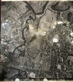
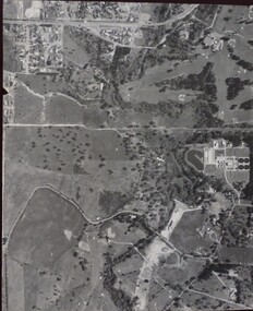
Aerial Photograph, Yan Yean M/S 7922 Run 17 No. 3833-18, 1/11/1984
... Aerial Photograph...Laminated black and white aerial photograph; adjoins 6227... Plenty Lower Plenty melbourne Aerial Photograph Yan Yean M/S 7922 ...Covers Viewbank area: North boundary Martin's Lane; South boundary Yarra River & Birrarung Park; East boundary east of Plenty RiverLaminated black and white aerial photograph; adjoins 6227 on west sideviewbank -
 Greensborough Historical Society
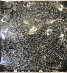
Aerial Photograph, Yan Yean M/S 7922 Run 17 No. 3833-20, 01/11/1984
... Aerial Photograph...Laminated black and white aerial photograph; adjoins 6226... Plenty Lower Plenty melbourne Aerial Photograph Yan Yean M/S 7922 ...Covers Rosanna and parts of Viewbank and Heidelberg. East boundary Price Park; West boundary Hurstbridge railway lineLaminated black and white aerial photograph; adjoins 6226 on east siderosanna, viewbank, heidelberg -
 Kew Historical Society Inc
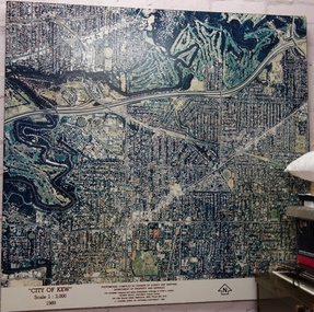
Photograph - Aerial Photograph, Division of Survey and Mapping, Department of Property and Services, City of Kew, Scale 1 : 3,000, 1989
... Aerial Photograph...Very large aerial photograph of “City of Kew” Scale 1... Aerial Photograph Photograph City of Kew, Scale 1 : 3,000, 1989 ...The City of Kew was a local government area about 4 kilometres east of Melbourne, the state capital of Victoria, Australia, on the southeast bank of the Yarra River. The city covered an area of 14.56 square kilometres, and existed from 1860 until 1994.Very large aerial photograph of “City of Kew” Scale 1 : 3,000. 1989. “City of Kew” Scale 1 : 3,000. 1989. Photomosaic compiled by Division of Survey and Mapping, Department of Property and Services. © Crown (State of Victoria) Copyright 1990.city of kew, kew (vic.), aerial photography -
 Churchill Island Heritage Farm
Photograph - Black and white composite aerial photograph
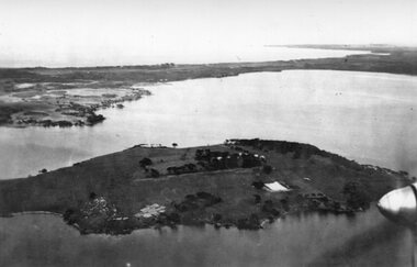
... Black and white composite aerial photograph...Black and white composite aerial photograph showing... composite aerial photograph Photograph Black and white composite ...Churchill Island Heritage Farm has a large photograph collection dating from the mid-nineteenth century to the last decade. This series of photographs show candid pictures taken by previous residents of the Island.Black and white composite aerial photograph showing Churchill Island and a portion of Phillip IslandCatalogue number written on reverse in pencil Written in pen on reverse '4 - aerial photos put together Taken?? + By whom??'churchill island -
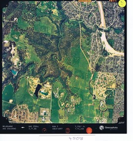 Greensborough Historical Society
Aerial photograph, Qascophoto, Greensborough, 03/11/1986
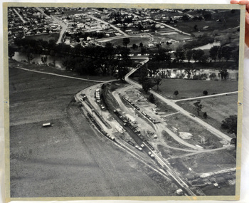
... Aerial photograph...Colour aerial photograph QAS 2504c run 5 3/11/86 1:15,500... Plenty Lower Plenty melbourne Aerial photograph Greensborough ...Aerial survey of Plenty Gorge Park area, including Greensborough by-pass construction and Metropolitan Ring Road reservation.An historical view of developing GreensboroughColour aerial photograph QAS 2504c run 5 3/11/86 1:15,500 by Qascophotoplenty gorge park, greensborough bypass, metropolitan ring road -
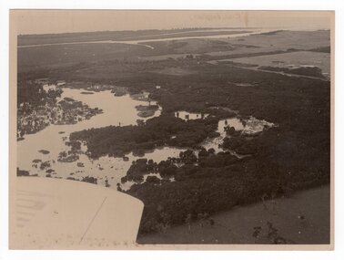 Churchill Island Heritage Farm
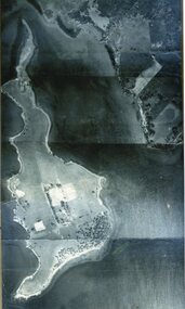
Aerial photograph of estuary, Unknown
... Aerial photograph of estuary...Black and white aerial photograph of estuary. Plane wing... Churchill Island Churchill Island gippsland Aerial photograph ...Churchill Island Heritage Farm has a large photograph collection dating from the mid-nineteenth century to the last decade. This series of photographs show events and people from the Churchill Island precinct and the enormous amount of collaboration and work that went into the development of the heritage area and making it accessible and interactive for visitors of all ages. Black and white aerial photograph of estuary. Plane wing visible in bottom left corner. White borderCatalogue number in pencil on reverse. "EJ4/28" on reverse in pencilchurchill island, aerial photography, estuary -
Stawell Historical Society Inc
Photograph - Aerial Photograph, Norwellan / AUNDE
... Aerial Photograph...Early Colour Aerial Photograph showing complete land...Aerial Photograph Photograph Norwellan / AUNDE Early Colour ...Textile Mill infrastructure when Norwellan North Western Woolen Mills became Norwellan Textiles then AUNDEEarly Colour Aerial Photograph showing complete land and infrastructure. Plastic frame imitating brown marble.industry -
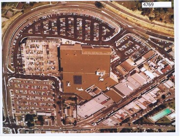 Greensborough Historical Society
Aerial Photograph, Greensborough Plaza Aerial View, 1979c
... Aerial Photograph...Early aerial photograph of Greensborough Plaza, 1970.... Plenty Lower Plenty melbourne Aerial Photograph Greensborough ...Early aerial photograph of Greensborough Plaza, 1970.Colour photocopy of aerial survey, laminatedgreensborough plaza -
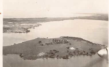 Churchill Island Heritage Farm
Aerial Photograph of Churchill Island, c.1930s
... Aerial Photograph of Churchill Island...Black and White aerial photograph of Churchill Island... Churchill Island Churchill Island gippsland Aerial Photograph ...Churchill Island Heritage Farm has a large photograph collection dating from the mid-nineteenth century to the last decade. Black and White aerial photograph of Churchill Island with Phillip Island in the background. A propeller can be seen in the foreground on the right side.Catalogue number written in pencil on reverse. 'Another air shot' written in pen on reverse. 'c.1930s' written in pencil on reverse.churchill island, aerial photography -
 Churchill Island Heritage Farm
Aerial Photograph of Churchill Island, 01/01/1940
... Aerial Photograph of Churchill Island...Black and White aerial photograph of Churchill Island... Churchill Island Churchill Island gippsland Aerial Photograph ...Churchill Island Heritage Farm has a large photograph collection dating from the mid-nineteenth century to the last decade. Black and White aerial photograph of Churchill Island with Phillip Island in the background. A propeller can be seen in the foreground on the right side.Catalogue number written in pencil on reverse. 'Churchill Is 1.1.40.' Written in pencil on reverse. 'Capt Patterson A.N.A' written in pencil on reverse '5''34' stamped in black ink on reverse. 'VELOX' stamped diagonally on reversechurchill island, aerial photography -
 Churchill Island Heritage Farm
Photograph - Aerial Photograph of Churchill Island, c.1940
... Aerial Photograph of Churchill Island...Black and White aerial photograph of Churchill Island taken... Churchill Island Churchill Island gippsland Aerial Photograph ...Churchill Island has a large photograph collection dating from the nineteenth century. This series consists of candid photographs of everyday life taken by previous residents of the island.Black and White aerial photograph of Churchill Island taken from a plane, the propeller partially visible in the bottom right corner.Catalogue number written on reverse in pencil. Handwritten in pen on reverse: '1940. FROM THE AIR'churchill island -
 Greensborough Historical Society
Aerial Photograph, Banyule Road / Lower Plenty Road, 1972c
... Aerial Photograph...Aerial survey photograph, black and white... Plenty Lower Plenty melbourne Aerial Photograph Banyule Road ...Viewbank, Rosanna and Lower Plenty area, showing Lower Plenty Road and Banyule RoadAerial survey photograph, black and whiteviewbank -
 Eltham District Historical Society Inc
Photograph - Aerial Photograph, Intersection of Main Road and Bridge Street, c.1995
... Aerial Photograph...Digital scan detail section of much larger aerial... melbourne Aerial Photograph Photograph Intersection of Main Road ...View of Main Road from Henry Street to Brougham Street across to the Diamond Creek showing the Eltham Shire Offices (demolished 1996), the Eltham Library (opened 1994)aerial photo, alistair knox park, bridge street, brougham street, central park, diamond creek (creek), eltham, eltham community centre, eltham courthouse, eltham justice precinct, eltham living and learning, franklin street, henry street, local history centre, main road -
 Orbost & District Historical Society
aerial photograph, 1970's
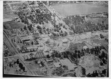
... aerial photograph...A large black and white aerial photograph of Orbost Railway... gippsland aerial photograph A large black and white aerial ...This photograph was taken prior to the closure of the Orbost -Bairnsdale freight line in 1987.The Orbost-Bairnsdale railway initially played a crucial role in developing agricultural industries in Gippsland as well as tourism. It opened in 1916 and operated until 1987, principally carrying timber and farming produce. In the early days of the railway's operation dedicated passenger trains ran but these ceased by the 1930s. The line was completely closed to freightage in 1987.The track infrastructure was dismantled in 1994 and has been redeveloped as the East Gippsland Rail Trail.A large black and white aerial photograph of Orbost Railway Station in the foreground and the Orbost township in the background. It has been pasted onto a piece of Masonite. railway photography orbost, railway photography orbost -
 Whitehorse Historical Society Inc.
Photograph - Aerial Photograph, Mitcham Reservoir
... Aerial Photograph...Black and white aerial photograph of Mitcham showing...Aerial Photograph Photograph Mitcham Reservoir Black ...Most of the area is now Thornton Crescent, Mitcham, a factory area. When erecting the present 'buildings', which are all single level, certain strategies were employed to ensure safety.Black and white aerial photograph of Mitcham showing the reservoir, Australian Tesselated Tiles with the clay pit at the rear, and Monarch Tiles (1914-16) in the foreground.mitcham reservoir, australian tesselated tile co. pty ltd, monarch terra cotta pty ltd -
 Bayside Gallery - Bayside City Council Art & Heritage Collection
Photograph, Department of Crown Lands and Survey, Victoria, Brighton, Brighton East and Bentleigh, c. 1965-71
... Aerial photograph.... This aerial photograph shows parts of Brighton, Brighton East...Black and white photograph. An aerial photograph showing... Black and white photograph. An aerial photograph showing parts ...The Department of Crown Lands and Survey (1857-1983) was responsible for the administration of survey and mapping and the sale, occupation and management of crown land throughout its existence. This aerial photograph shows parts of Brighton, Brighton East and Bentleigh and was taken circa 1965-71.brighton, department of crown lands and survey, aerial photograph, bayside, port phillip bay, map, cartographic material, bentleigh, brighton east, dendy park, dendy street, centre road, nepean highway, south road, football -
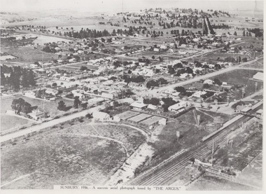 Sunbury & District Heritage Association Inc
Photograph, 1936
... A black and white aerial photograph with a cream border...SUNBURY 1936 - A SOUVENIR AERIAL PHOTOGRAPH ISSUED... Photograph Photograph A black and white aerial photograph ...The aerial view of Sunbury was featured in The Argus newspaper in 1936 in recognition of 100 years of European settlement of the area. It shows the extent of the township in 1936 which extended from the railway line in the west to the Jackson Creek in the east and the Sunbury Asylum in the south and northwards towards Macedon Street. The photograph was taken when Sunbury was a country settlement 25 miles ( 37 kms) from Melbourne. Since the 1980s the area grown rapidly and is now an outer suburb of Melbourne.A black and white aerial photograph with a cream border of the Sunbury township. SUNBURY 1936 - A SOUVENIR AERIAL PHOTOGRAPH ISSUED BY THE ARGUS.aerial photographs -
 Bayside Gallery - Bayside City Council Art & Heritage Collection
Photograph, Department of Crown Lands and Survey, Victoria, Brighton, Brighton East and Bentleigh, c. 1965-71
... Aerial photograph.... This aerial photograph shows parts of Brighton and Brighton East...Black and white photograph. An aerial photograph showing... Black and white photograph. An aerial photograph showing parts ...The Department of Crown Lands and Survey (1857-1983) was responsible for the administration of survey and mapping and the sale, occupation and management of crown land throughout its existence. This aerial photograph shows parts of Brighton and Brighton East and was taken circa 1965-71.brighton, department of crown lands and survey, aerial photograph, bayside, port phillip bay, map, cartographic material, brighton east, dendy park, dendy street, centre road, nepean highway, south road, brighton golf course, golf -
Glenelg Shire Council Cultural Collection
Photograph - Photograph - Aerial photograph of coastline around Portland Victoria, c. 1954
... Photograph - Aerial photograph of coastline around Portland...Black and white aerial photograph of coastline around... Cliff Street Portland great-ocean-road Photograph - Aerial ...Black and white aerial photograph of coastline around Portland. Black border, bottom edge, section of larger photo, approximately 50%, only land visible.Front: 'PORTLA' -printed, white border -
Glenelg Shire Council Cultural Collection
Photograph - Photograph - Aerial photograph of coastline around Portland, Victoria, c. 1954
... Photograph - Aerial photograph of coastline around Portland...Black and white aerial photograph of coastline around... Cliff Street Portland great-ocean-road Photograph - Aerial ...Black and white aerial photograph of coastline around Portland. Black border, scale all sides, 5 rows of 3 't' at regular intervals. Mostly landFront: '607 - 52 ' - handwritten, white, border 'RUN 7 ' 'PORTLAND', printed, white, border -
Tatura Irrigation & Wartime Camps Museum
Aerial Photograph, 1959
... Aerial Photograph... Tatura the-murray Aerial Photograph Enlarged aerial photo ...Enlarged aerial photo of Tatura township taken by J. Underwood (Kyabram) in January 1959. Photo framed with glass front.Tatura Jan 1959. Arthur J. Underwood Photographer Tel. Kyabram 629tatura, aerial photography, photography, photograph, slides, film -
Glenelg Shire Council Cultural Collection
Photograph - Photograph - Aerial photograph of Portland harbour taken from the north east, 1967
... Photograph - Aerial photograph of Portland harbour taken...Black and white unframed aerial photograph of Portland... Cliff Street Portland great-ocean-road Photograph - Aerial ...Front: (no inscriptions) Back: Portland Harbour 1967/ No 6 berth under construction (ocean pier and railway pier still in existence)port of portland archives -
Glenelg Shire Council Cultural Collection
Photograph - Photograph - Aerial photograph of coastline, Portland Victoria, c. 1954
... Photograph - Aerial photograph of coastline, Portland...Black and white aerial photograph of coastline around... Cliff Street Portland great-ocean-road Photograph - Aerial ...Black and white aerial photograph of coastline around Portland. Black border, scale all sides, 5 rows of 3 't' at regular intervals. 80/20 ocean to landFront: '784 - 147 ' - handwritten, white, border 'RUN 7 A PORTLAND', printed, white, border -
 Ballarat Heritage Services
Aerial digital photograph, L.J. Gervasoni, Mouth of the Yarra River and Westgate on approach to Melbourne's Tullamarine Airport, 2016
... Aerial digital photograph...aerial photograph... Office goldfields Aerial digital photograph Mouth of the Yarra ...hoto taken from flight in to Melbourne International airport.Digital aerial image of Melbourne, Victoria.aerial, landscape, cityscape, mouth, yarra river, west gate bridge, aerial photograph -
Glenelg Shire Council Cultural Collection
Photograph - Photograph - Aerial photograph of an area of Portland, Victoria, 1955
... Photograph - Aerial photograph of an area of Portland...A black and white aerial photograph taken from the N.W... Cliff Street Portland great-ocean-road Photograph - Aerial ...Port of Portland CollectionA black and white aerial photograph taken from the N.W. of T.B.& S. abattoir, red brick wool store, petroleum installations, north/central Portland residential areas and Portland Harbour.Front: NOV 1955 'AIRSPY PHOTO' ref NO 2/b/74port of portland -
 Eltham District Historical Society Inc
Work on paper (Sub-Item) - Aerial Photograph, Diamond Creek from Yarra River to Wattletree Road, Eltham
... Aerial Photograph...Black and white aerial photograph witrh key features around... melbourne Aerial Photograph Work on paper Diamond Creek from Yarra ...Black and white aerial photograph witrh key features around the central place of Eltham township marked inluding Yarra River, Main Road, Bridge Street and Ryans Road, Eltham North land development, real estate, aerial view, eltham, eltham north -
 Bayside Gallery - Bayside City Council Art & Heritage Collection
Photograph, Department of Crown Lands and Survey, Victoria, Brighton, Elwood and Elsternwick, c. 1965-71
... Aerial photograph.... This aerial photograph shows parts of Brighton, Elwood and Elsternwick...Black and white photograph. An aerial photograph showing... Black and white photograph. An aerial photograph showing parts ...The Department of Crown Lands and Survey (1857-1983) was responsible for the administration of survey and mapping and the sale, occupation and management of crown land throughout its existence. This aerial photograph shows parts of Brighton, Elwood and Elsternwick and was taken circa 1965-71.brighton, department of crown lands and survey, aerial photograph, bayside, port phillip bay, map, cartographic material, elwood, elsternwick, elsternwick park, elwood tram depot, elwood pier, new street, glen huntly road, st kilda street, nepean highway -
Glenelg Shire Council Cultural Collection
Photograph - Photograph - Aerial photograph of coastline around Portland, Victoria, c. 1954
... Photograph - Aerial photograph of coastline around Portland...Black and white aerial photograph of coastline around... Cliff Street Portland great-ocean-road Photograph - Aerial ...Black and white aerial photograph of coastline around Portland. Black border, scale all sides, 5 rows of 3 't' at regular intervals. Bottom 20% ocean, rest land, separated by beach.Front: '607 - 88' - handwritten, white, border 'RUN - 6 PORTLAND', printed, white, border -
 Bayside Gallery - Bayside City Council Art & Heritage Collection
Photograph, Department of Crown Lands and Survey, Victoria, Melbourne Project: Brighton, 1976
... Aerial photograph.... This aerial photograph shows parts of Brighton and was taken on 1...Black and white photograph. An aerial photograph showing... and white photograph. An aerial photograph showing parts ...The Department of Crown Lands and Survey (1857-1983) was responsible for the administration of survey and mapping and the sale, occupation and management of crown land throughout its existence. This aerial photograph shows parts of Brighton and was taken on 1 December 1976brighton, department of crown lands and survey, aerial photograph, bayside, port phillip bay, map, cartographic material, melbourne project 1976, brighton yacht club, middle brighton baths, north road, st kilda street, new street