Showing 1703 items matching "aerial photographs"
-
 Sunshine and District Historical Society Incorporated
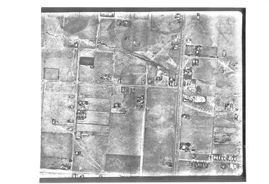
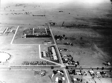
Photograph - Aerial Photographs of Sunshine 1946, 1946
... Aerial Photographs of Sunshine 1946...Aerial Photograph...Copy of aerial photographs of Sunshine 1946...Aerial Photographs of Sunshine 1946 Collection of 8 black and white aerial photographs of Sunshine...Aerial Photograph Aerial Photographs of Sunshine 1946 Collection of 8 black and white aerial photographs of Sunshine Copy of aerial photographs of Sunshine 1946 Photograph Aerial Photographs of Sunshine 1946 ...Aerial Photographs of Sunshine 1946 Collection of 8 black and white aerial photographs of Sunshineaerial photograph -
 Box Hill Historical Society
Photograph - Aerial Photographs
... Aerial Photographs...Aerial photographs...Aerial photograph showing Eram Park between Station Street and Middleborough Road (looking East)...Box Hill Historical Society Box Hill Heritage Centre Suite 7 Town Hall Hub Box Hill melbourne Aerial photograph showing Eram Park between Station Street and Middleborough Road (looking East) Aerial photographs Station Street Middleborough Road Eram Park Parks and reserves Photograph Aerial Photographs ...Aerial photograph showing Eram Park between Station Street and Middleborough Road (looking East)aerial photographs, station street, middleborough road, eram park, parks and reserves -
Box Hill Historical Society
Photograph - Aerial photographs
... Aerial photographs......Aerial photographs...Aerial photograph of Box Hill, showing Nelson Road, Station Street, Box Hill Brickworks and Whitehorse Road...Box Hill Historical Society Box Hill Heritage Centre Suite 7 Town Hall Hub Box Hill melbourne Aerial photograph of Box Hill, showing Nelson Road, Station Street, Box Hill Brickworks and Whitehorse Road Nelson Road Station Street Brickworks Whitehorse Plaza Aerial photographs Photograph Aerial photographs ...Aerial photograph of Box Hill, showing Nelson Road, Station Street, Box Hill Brickworks and Whitehorse Roadnelson road, station street, brickworks, whitehorse plaza, aerial photographs -
 Whitehorse Historical Society Inc.
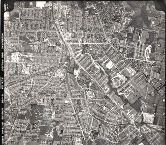
Photograph - Aerial photographs x 10, Miscellaneous Aerial Photos, 1966
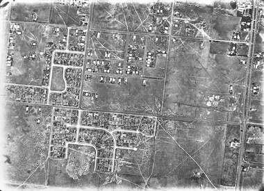
... Aerial photographs x 10...1966 Aerial photographs...Ten aerial photographs in mainly the Eastern suburbs...Whitehorse Historical Society Inc. 2-10 Deep Creek Road Mitcham melbourne 1966 Aerial photographs Aerial photos eastern suburbs 1966 Ten aerial photographs in mainly the Eastern suburbs Miscellaneous Aerial Photos Photograph Aerial photographs x 10 ...1966 Aerial photographsTen aerial photographs in mainly the Eastern suburbsaerial photos, eastern suburbs, 1966 -
Box Hill Historical Society
Photograph - Aerial Photographs
... Aerial Photographs...Aerial photographs...Aerial photograph showing Nelson Road, Whitehorse Road, Box Hill Hospital, Whitehorse Plaza, Box Hill Brickworks and Surrey Park. ...See also B0076. Aerial photographs Whitehorse Road Nelson Road Whitehorse Plaza Hospitals Shopping centres Brickworks Surrey Park Photograph Aerial Photographs ...Aerial photograph showing Nelson Road, Whitehorse Road, Box Hill Hospital, Whitehorse Plaza, Box Hill Brickworks and Surrey Park. See also B0076.aerial photographs, whitehorse road, nelson road, whitehorse plaza, hospitals, shopping centres, brickworks, surrey park -
Box Hill Historical Society
Photograph - Aerial Photographs
... Aerial Photographs......Aerial photographs...Aerial photograph of Bank street, Box Hill - looking west - showing the ANZ Bank on the corner of Station Street and Main Street, and Whitehorse Plaza in the background. ...Whitehorse Plaza ANZ Bank Bank Street Station Street Main Street Shopping centres Banks Transport Water towers Telecommunications equipment Aerial photographs Photograph Aerial Photographs ...Aerial photograph of Bank street, Box Hill - looking west - showing the ANZ Bank on the corner of Station Street and Main Street, and Whitehorse Plaza in the background. C.1970's. Railway line visible through the trees. The water tower in Elgar Road and the communications tower in Canterbury Road is visible.whitehorse plaza, anz bank, bank street, station street, main street, shopping centres, banks, transport, water towers, telecommunications equipment, aerial photographs -
 Melbourne Tram Museum
Drawing, Melbourne & Metropolitan Tramways Board (MMTB), Aerial photographs Bundoora Tram Extensions, Plenty Road – MMTB Drawings – 12/1979, Bundoora Extension – Metropolitan Transit Authority – 2/1983, John-Connell – Mott Hay and Anderson – Preliminary drawings for the Latrobe Modal Interchange – August 1984, 1979 to 1984
... Aerial photographs Bundoora Tram Extensions, Plenty Road – MMTB Drawings – 12/1979, Bundoora Extension – Metropolitan Transit Authority – 2/1983, John-Connell – Mott Hay and Anderson – Preliminary drawings for the Latrobe Modal Interchange – August 1984....Large print – Aerial photographs Bundoora Tram Extensions Stage 2 – Albert St to Kingsbury Drive Stage 3 – Kingsbury Drive to Settlement Road Has been rolled, left hand edge damaged, right hand edge torn Compiled by the ROW Division – 2/1981. ...On rear of aerial photograph sheet - at right hand end “Bundoora Tram Extension – Official MMTB Plans” in felt pen....Melbourne Tram Museum 8 Wallen Road Hawthorn melbourne Trams tramways Plenty Rd Bundoora Latrobe University MMTB Construction MTA On rear of aerial photograph sheet - at right hand end “Bundoora Tram Extension – Official MMTB Plans” in felt pen. ...Set of drawings for the MMTB Plenty Road extension in 1979, MTA extension to Bundoora in 1983 and the Latrobe Uni Modal Interchange - 1984. Large print – Aerial photographs Bundoora Tram Extensions Stage 2 – Albert St to Kingsbury Drive Stage 3 – Kingsbury Drive to Settlement Road Has been rolled, left hand edge damaged, right hand edge torn Compiled by the ROW Division – 2/1981. Has written on rear at right hand end “Bundoora Tram Extension – Official MMTB Plans” 760H x 1190W Plenty Road – MMTB Drawings – 12/1979 P15123 Tyler St to Walsal Avenue P15124 Walsal Ave t McColl St P15125 McColl St to Dorrington Avenue Bundoora Extension – Metropolitan Transit Authority – 2/1983 P15400 Dorrington Avenue to Barwon Avenue P15401 Barwon Avenue to Nicholson Ave P15402 Nicholson St to Barling Park P15403 Barling Park to Darebin Creek P15404 Darebin Creek to Scott Grove P15405 Scott Grove to Clunes Street P15406 Clunes St to Cash St P15408 Cash St to Bundoora Park P15409 Bundoora Park to Larundel Hospital P15410 At Larundel Hospital P15411 Larundel Hospital to Marne Court P15412 Marne Court to Cherrywood Court P15413 Cherrywood Court to Morwell Ave P15414 Morwell Ave to Grimshaw St P15415 Grimshaw St to Nickson Street P15416 Nickson St to McLeans Road John-Connell – Mott Hay and Anderson – Preliminary drawings for the Latrobe Modal Interchange – August 1984. 8094-A-20 Set Out Plan and Paving Details 8094-A-21 Elevations 8094-A-22 Sections 8094-A-23 Roof Plan and Stormwater Layout 8094-A-24 Canopy Details 8094-A-25 Toilet Block and Waiting Room 8094-A-28 Miscellaneous DetailsOn rear of aerial photograph sheet - at right hand end “Bundoora Tram Extension – Official MMTB Plans” in felt pen.trams, tramways, plenty rd, bundoora, latrobe university, mmtb, construction, mta -
 Federation University Historical Collection
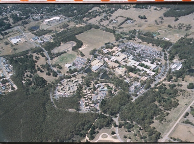
photographs and negatives, Aerial Photographs of Ballarat and Mount Helen, c1985
... Aerial Photographs of Ballarat and Mount Helen......aerial photographs...Thirteen colour photographs and 47 negative strips of aerial views of Ballarat, Mt Helen and Mount Buninyong...Barker Library (top floor) Mount Helen goldfields ballarat mount helen buninyong aerial photographs student residences bella guering residence peter lalor residences mount helen campus camp street campus arts academy lake wendouree ballarat cbd ballarat school of mines smb campus Thirteen colour photographs and 47 negative strips of aerial views of Ballarat, Mt Helen and Mount Buninyong Aerial Photographs of Ballarat and Mount Helen photographs and negatives ...Thirteen colour photographs and 47 negative strips of aerial views of Ballarat, Mt Helen and Mount Buninyongballarat, mount helen, buninyong, aerial photographs, student residences, bella guering residence, peter lalor residences, mount helen campus, camp street campus, arts academy, lake wendouree, ballarat cbd, ballarat school of mines, smb campus -
Whitehorse Historical Society Inc.
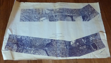
Map, Aerial photographs Nunawading, 1972
... Aerial photographs Nunawading......Aerial photographs...Sheets 39/2 and 34/28 missing. Aerial photographs Nunawading Map Map ...Department of Crown Lands and Survey, Melbourne, 1972.Department of Crown Lands and Survey, Melbourne, 1972. Project runs 34 - 39 - City of Nunawading. frames numbered from South to North boundaries, each strip numbered from West to east. The series extends further West to Box Hill and East to Ringwood than the 1970 project. No index map. Sheets 39/2 and 34/28 missing.non-fictionDepartment of Crown Lands and Survey, Melbourne, 1972.victoria. department of crown lands and survey, aerial photographs, nunawading, mitcham, blackburn, blackburn north, blackburn south, forest hill, vermont, burwood east, box hill, ringwood, vermont south -
Whitehorse Historical Society Inc.
Map, Aerial photographs Nunawading, 1976
... Aerial photographs Nunawading......Aerial Photographs...Sheets 30/8 and 30/9 missing. Aerial photographs Nunawading Map Map ...Department of Crown Lands and Survey, Melbourne, 1976 Project.Department of Crown Lands and Survey, Melbourne, 1976 Project. Runs 29 - 33 City of Nunawading. Frames numbered from South to North boundaries, each strip numbered from West to East. No index map. Sheets 30/8 and 30/9 missing.non-fictionDepartment of Crown Lands and Survey, Melbourne, 1976 Project. victoria. department of crown lands and survey, aerial photographs, nunawading, mitcham, blackburn, blackburn north, blackburn south, forest hill, vermont, vermont south, burwood east, box hill, ringwood -
Whitehorse Historical Society Inc.
Map, Aerial Photographs Nunawading, 1970
... Aerial Photographs Nunawading......Aerial photographs...See table of index and photo numbers attached. Aerial Photographs Nunawading Map Map ...State Aerial Survey, Melbourne 1970.State Aerial Survey, Melbourne 1970. Project runs 34 - 39 - City of Nunawading. Frames numbered from South to North boundaries, each strip numbered from East to West. See table of index and photo numbers attached.non-fictionState Aerial Survey, Melbourne 1970.state aerial survey, aerial photographs, nunawading, mitcham, blackburn, blackburn north, blackburn south, forest hill, vermont, burwood east, vermont south -
 Stawell Historical Society Inc
Photograph, Stawell Aerial Photographs
... Stawell Aerial Photographs...3 Aerial photographs of Stawell possibly mining Surveys for Stawell Gold Mines...Stawell Historical Society Inc 46 Longfield St Stawell grampians Coordinates 3 Aerial photographs of Stawell possibly mining Surveys for Stawell Gold Mines Stawell Aerial Photographs Photograph ...3 Aerial photographs of Stawell possibly mining Surveys for Stawell Gold MinesCoordinates -
 Sunbury Family History and Heritage Society Inc.
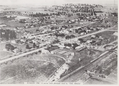
Photograph, 1936
... Aerial photographs...A non-digital black and white aerial photograph with a cream border of the Sunbury township. ...SUNBURY 1936 - A SOUVENIR AERIAL PHOTOGRAPH ISSUED BY THE ARGUS....Since the 1980s the area grown rapidly and is now an outer suburb of Melbourne. Aerial photographs Sunbury Newspaper photographs SUNBURY 1936 - A SOUVENIR AERIAL PHOTOGRAPH ISSUED BY THE ARGUS. ...The aerial view of Sunbury was featured in The Argus newspaper in 1936 in recognition of 100 years of European settlement of the area. It shows the extent of the township in 1936 which extended from the railway line in the west to the Jackson Creek in the east and the Sunbury Asylum in the south and northwards towards Macedon Street. The photograph was taken when Sunbury was a country settlement 25 miles ( 37 kms) from Melbourne. Since the 1980s the area grown rapidly and is now an outer suburb of Melbourne.A non-digital black and white aerial photograph with a cream border of the Sunbury township. SUNBURY 1936 - A SOUVENIR AERIAL PHOTOGRAPH ISSUED BY THE ARGUS.aerial photographs, sunbury, newspaper photographs -
Box Hill Historical Society
Photograph - Aerial Photographs, Simon Fox, 1/12/1994
... Aerial Photographs...Aerial photographs...Box Hill Historical Society Box Hill Heritage Centre Suite 7 Town Hall Hub Box Hill melbourne Aerial view looking south and showing Box Hill Hospital, Whitehorse Plaza, Surrey Park, Water Tower and the Brickworks. Aerial photographs Hospitals Whitehorse Plaza Surrey Park Water towers Brickworks Shopping centres Photograph Aerial Photographs Simon Fox ...Aerial view looking south and showing Box Hill Hospital, Whitehorse Plaza, Surrey Park, Water Tower and the Brickworks.aerial photographs, hospitals, whitehorse plaza, surrey park, water towers, brickworks, shopping centres -
Box Hill Historical Society
Photograph - Aerial Photographs
... Aerial Photographs...Aerial photographs...The railway line and Laburnum Station are also visible. Aerial photographs Box Hill High School Box Hill Football Ground Whitehorse Road Middleborough Road Schools Parks and reserves Railways Railway stations Photograph Aerial Photographs ...Aerial view showing Box Hill Football Ground and Box Hill High School at the corner of Whitehorse Road and Middleborough Road. The railway line and Laburnum Station are also visible.aerial photographs, box hill high school, box hill football ground, whitehorse road, middleborough road, schools, parks and reserves, railways, railway stations -
Box Hill Historical Society
Photograph - Aerial Photographs
... Aerial Photographs...Aerial photographs...Shows Burwood Drive-In Theatre, bottom right. Aerial photographs Burwood Highway Elgar Road Drive in theatres Skyline Photograph Aerial Photographs ...Aerial view of Box Hill showing corner of Burwood Highway and Elgar Road, looking north to Box Hill. Shows Burwood Drive-In Theatre, bottom right.aerial photographs, burwood highway, elgar road, drive in theatres, skyline -
 Sunshine and District Historical Society Incorporated
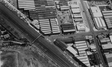
Photograph - Aerial photographs of McKay factory, 1960's
... Aerial photographs of McKay factory...Aerial photographs of McKay factory...2 aerial views of McKay factory approximately early 1960s Photos most likely taken for Massey Ferguson showing factory building and adjacent land and shops|Photograph 1 center left McKay gardens curator's house Bendigo Railway line and ramp to Devonshire Road Second clock tower and show rooms Factory office at Russell Street entrance to factory Shops built on land once engine works machinist Portion of McKay Factory Photo taken after Massey Ferguson take over Bolt shop dismantled Land Sold for shops|Photograph 2 Aerial view of McKay Factory 1960s approximately Hampshire Road right hand side Fire station on corner of Hertford Road with Woodmill Site Later years Sunshine Plaza Shopping Centre Stony Creek still visible with garage private and car park adjacent to creek Service Street then Duplicates Building Duplicate parts of McKay factory for supply of duplicate parts Remainder of photo factory site...Sunshine Harvester Works Massey Ferguson Employ 2 aerial views of McKay factory approximately early 1960s Photos most likely taken for Massey Ferguson showing factory building and adjacent land and shops|Photograph 1 center left McKay gardens curator's house Bendigo Railway line and ramp to Devonshire Road Second clock tower and show rooms Factory office at Russell Street entrance to factory Shops built on land once engine works machinist Portion of McKay Factory Photo taken after Massey Ferguson take over Bolt shop dismantled Land Sold for shops|Photograph 2 Aerial view of McKay Factory 1960s approximately Hampshire Road right hand side Fire station on corner of Hertford Road with Woodmill Site Later years Sunshine Plaza Shopping Centre Stony Creek still visible with garage private and car park adjacent to creek Service Street then Duplicates Building Duplicate parts of McKay factory for supply of duplicate parts Remainder of photo factory site Aerial photographs of McKay factory Photograph Aerial photographs of McKay factory ...2 aerial views of McKay factory approximately early 1960s Photos most likely taken for Massey Ferguson showing factory building and adjacent land and shops|Photograph 1 center left McKay gardens curator's house Bendigo Railway line and ramp to Devonshire Road Second clock tower and show rooms Factory office at Russell Street entrance to factory Shops built on land once engine works machinist Portion of McKay Factory Photo taken after Massey Ferguson take over Bolt shop dismantled Land Sold for shops|Photograph 2 Aerial view of McKay Factory 1960s approximately Hampshire Road right hand side Fire station on corner of Hertford Road with Woodmill Site Later years Sunshine Plaza Shopping Centre Stony Creek still visible with garage private and car park adjacent to creek Service Street then Duplicates Building Duplicate parts of McKay factory for supply of duplicate parts Remainder of photo factory sitesunshine harvester works, massey ferguson, employ -
 Sunshine and District Historical Society Incorporated
Photograph - Set of aerial photographs of Sunshine at 27 January 1946, Government agency, Taken 27 January, 1946. Copies made c.2000
... Set of aerial photographs of Sunshine at 27 January 1946...... Aerial Photograph...Set of aerial photographs of Sunshine at 27 January 1946...The rest of the inscription is the same Set of aerial photographs of Sunshine at 27 January 1946 Photograph Set of aerial photographs of Sunshine at 27 January 1946 Government agency ...The photographs were obtained by Jim Cannon of Sunshine. Copies were made by Information Victoria for Norman Carlton. They were later given to Brian OReilly who donated them to Sunshine and District Historical Society.VIC- 211 27.1.46 Run 26 Project No 5 Melbourne Metropolitan area Some photographs are from Run 27. The rest of the inscription is the samesunshine, aerial photograph -
 Sunshine and District Historical Society Incorporated
Photograph - Deer Park Aerial Photographs
... Deer Park Aerial Photographs...... Aerial Photograph...Collection of 4 black and white aerial photographs of Deer Park...Deer Park Aerial Photograph Photograph Station Road and Ballarat Road Intersection including Railway Station in background Leathercloth Factory Houses in Ballarat Road and Station Road|Photograph Station Road and Ballarat Road Intersection including Railway Station in background Leathercloth Factory Houses in Ballarat Road and Station Road and Deer Park Football Oval|Photograph Leathercloth Factory Houses in Ballarat Road The Hunt Club and Deer Park Football Oval|Photograph ICI and Kororoit Creek and Deer Park Hotel Collection of 4 black and white aerial photographs of Deer Park Photograph Deer Park Aerial Photographs ...Photograph Station Road and Ballarat Road Intersection including Railway Station in background Leathercloth Factory Houses in Ballarat Road and Station Road|Photograph Station Road and Ballarat Road Intersection including Railway Station in background Leathercloth Factory Houses in Ballarat Road and Station Road and Deer Park Football Oval|Photograph Leathercloth Factory Houses in Ballarat Road The Hunt Club and Deer Park Football Oval|Photograph ICI and Kororoit Creek and Deer Park Hoteldeer park, aerial photograph -
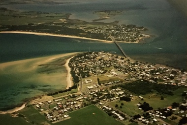 Phillip Island and District Historical Society Inc.
Photograph, Aerial photographs of Phillip Island, 1990s
... Aerial photographs of Phillip Island...Coloured photographs showing aerial views of the townships and the Island....Aerial photographs of Phillip Island Photograph ...Coloured photographs showing aerial views of the townships and the Island.rhyll, photographs, cowes, san remo, newhaven, aerial views of phillip island -
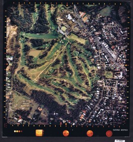
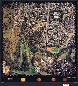
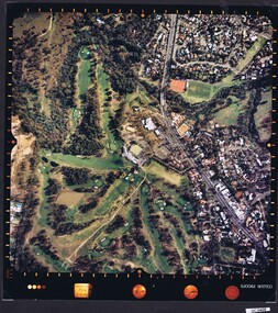
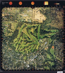 Heidelberg Golf Club
Photograph - Aerial Photograph, Heidelberg Golf Course 2000, 01/05/1980
... Aerial Photograph...Aerial photographs...Aerial photograph of Heidelberg Golf Club course in 1980, showing the course layout and surrounding land use....Aerial photograph, colour....Aerial photographs Heidelberg Golf Club Lower Plenty Printed on edge of photo: "Colour proof", "LandSur756" Aerial photograph, colour. ...Aerial photograph of Heidelberg Golf Club course in 1980, showing the course layout and surrounding land use.Aerial photograph, colour.Printed on edge of photo: "Colour proof", "LandSur756"aerial photographs, heidelberg golf club, lower plenty -
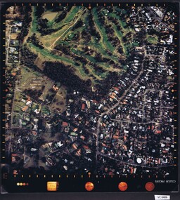 Heidelberg Golf Club
Photograph - Aerial Photograph, Heidelberg Golf Course 2000, 01/05/1980
... Aerial Photograph...Aerial photographs...Aerial photograph of Heidelberg Golf Club course in 1980, showing layout of course and surrounding land use....Aerial photograph, colour....Aerial photographs Heidelberg Golf Club Lower Plenty Printed on edge of photo: "Colour proof", "LandSur756" Aerial photograph, colour. ...Aerial photograph of Heidelberg Golf Club course in 1980, showing layout of course and surrounding land use.Aerial photograph, colour.Printed on edge of photo: "Colour proof", "LandSur756"aerial photographs, heidelberg golf club, lower plenty -
 Sunshine and District Historical Society Incorporated
Photograph - Two aerial photographs of City of Sunshine, Dept Crown Lands and Survey
... Two aerial photographs of City of Sunshine...... Aerial Photograph...Two aerial photographs of City of Sunshine from Dept. ...City of Sunshine Aerial Photograph Two aerial photographs of City of Sunshine from Dept. ...city of sunshine, aerial photograph -
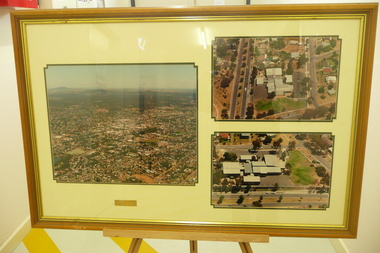 Bendigo Historical Society Inc.
Photograph - BENDIGO NORTH P.S. COLLECTION: AERIAL PHOTOGRAPHS, 1996
... COLLECTION: AERIAL PHOTOGRAPHS...3 Large aerial photographs of Bendigo North Primary School under glass in a timber frame. ...COLLECTION: AERIAL PHOTOGRAPHS ...3 Large aerial photographs of Bendigo North Primary School under glass in a timber frame. Deframed 2022photograph, building, bendigo north school -
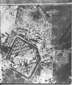 Tatura Irrigation & Wartime Camps Museum
Photograph, Aerial photo of camp 3 1946
... ...aerial photographs...Aerial photograph, taken in 1946 of the Rushworth internment camp....Black and white aerial photograph of camp 3 Rushworth showing layout of the camp....Tatura Irrigation & Wartime Camps Museum 49 Hogan Street Tatura the-murray Aerial photograph, taken in 1946 of the Rushworth internment camp. aerial photo of camp 3 taken in 1946 Rushworth internment camp aerial photographs Victorian internment camps Black and white aerial photograph of camp 3 Rushworth showing layout of the camp. ...Aerial photograph, taken in 1946 of the Rushworth internment camp.Black and white aerial photograph of camp 3 Rushworth showing layout of the camp.aerial photo of camp 3, taken in 1946, rushworth internment camp, aerial photographs, victorian internment camps -
 Sunshine and District Historical Society Incorporated
Photograph - Aerial Photographs Of Melbourne Metropolitan Area 1989, Qascophoto, 17th November 1989 & 28th November 1989
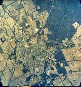
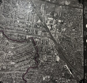
... Aerial Photographs Of Melbourne Metropolitan Area 1989...... Aerial Photograph...McKay Trade Wing, Tottenham Hotel, Sunshine Carvan Park 953.14 - Aerial Photographs Of Melbourne Metropolitan Area 1989.JPG Suburb(s): Derrimut, Mt. ...McKay Trade Wing, Tottenham Hotel, Sunshine Carvan Park 953.14 - Aerial Photographs Of Melbourne Metropolitan Area 1989.JPG Suburb(s): Derrimut, Mt. ...953.01 - Aerial Photographs Of Melbourne Metropolitan Area 1989.JPG Suburb(s): Ardeer, Deer Park (Now Derrimut), Sunshine West Area bounded by: Railway Parade (North), Paramount Bouvard (South), Allison Street (East), Approx Station Road (West) Points of Interest: IVI Explosive Bunkers, Railway Siding into ICI off Forrest Street, Former Railway Station Tilburn Road, Sunshine Technical School Annex, Croatian Catholic Centre Sunshine Fitzgerald Road 953.02 - Aerial Photographs Of Melbourne Metropolitan Area 1989.JPG Suburb(s): Brooklyn, Yarraville Area bounded by: South of Somerville Road (North), Westgate Freeway (South), Urwin Street (East). West of McDonald Road (West) Points of Interest: State Electricity Commission of Victoria (SECV) Stores, Brooklyn Wool Stores, Brooklyn Primary School, Half Moon Caravan Park, Footscray Cemetery, Rheems, James Hardy 953.03 - Aerial Photographs Of Melbourne Metropolitan Area 1989.JPG Suburb(s): Ascot Vale, Maribyrnong Area bounded by: Raleigh Road (North), River Street and James Street (South), Holdsworth Street (East), West of Van Ness Avenue (West) Points of Interest: Highpoint City, Fairbairn Park, Hume Pipes, Riverside Golf Course, ICI Laboratories 953.04 - Aerial Photographs Of Melbourne Metropolitan Area 1989.JPG Suburb(s): Albion, Ardeer, Sunshine, Sunshine West Area bounded by: Dubbo Street (North), South of Glengala Road (South), West of Sydney Street (East), Vernon Crescent (West) Points of Interest: Ainsworth Reserve, Selwyn Park, St. Paul Church, Marian College, Ardeer Primary School, Glengala Road Shopping Centre, 953.05 - Aerial Photographs Of Melbourne Metropolitan Area 1989.JPG Suburb(s): Deer Park Area bounded by: Station Road (East), Marcellin Court (West), Irvine Street (North), Deer Street (South) Points of Interest: Deer Park Primary School, Deer Park Play Kindergaten, Deer Park Shopping Centre, St. Peter Chanel Church & School 953.06 - Aerial Photographs Of Melbourne Metropolitan Area 1989.JPG Suburb(s): Derrimut Area bounded by: Future Ring Road (North), South of Boundary Road (South), East of Andersons Swamp (East), West of Fitzgerald Road (West) Points of Interest: Andersons Swamp 953.07 - Aerial Photographs Of Melbourne Metropolitan Area 1989.JPG Suburb(s): Sunshine West Area bounded by: East of Fairbairn Road (East), East of Fitzgerald Road (West), North of Mailey Street (North), South of Talintyre Road (South) Points of Interest: Sunshine West High School, Sunshine Heights Primary School, Castley Reserve, Talintyre Reserve, Talintyre Road Shops, St. Peters School, Sunshine Golf Course, Ralph Reserve, Glengala Primary School 953.08 - Aerial Photographs Of Melbourne Metropolitan Area 1989.JPG Suburb(s): Derrimut, Ravenhall Area bounded by: East of Station Road, now Derrimut Road (East), West of Robinsons Road (West), South of Railway Line (North), North of Future Deer Park Bypass Points of Interest: Old Farms and Quarries 953.09 - Aerial Photographs Of Melbourne Metropolitan Area 1989.JPG Suburb(s): Sydenham, Taylors Lakes, Taylors Hill Area bounded by: Taylors Creek (North), Future Hume Drive (South), West of Future Parmelia Drive (East), Future Hawthorn Grove (West) Points of Interest: Sydenham Reservoir, Sydenham Railway Station, Sydenham Memorial Hall, Sydenham Primary School, Sydenham Recreation Reserve, Catholic Regional College Sydenham, Kingdom Hall of Jehovah's Witnesses 953.10 - Aerial Photographs Of Melbourne Metropolitan Area 1989.JPG Suburb(s): Brooklyn, Tottenham Area bounded by: Stony Creek (North), South of Somerville Road (South), Holmwood Road (East), West of McDonald Road (West) Points of Interest: Monsanto, Dalgety's, Wool Stores, Sims Metals, Farmer & Graziers, Olex Cables, Redbrook Carpets, May & Baker, Cargil Oil, Smorgans 953.11 - Aerial Photographs Of Melbourne Metropolitan Area 1989.JPG Suburb(s): Brooklyn Area bounded by: South of Fourth Avenue (North), South of Bunting Road (South), West of McDonald Road, East of Fitzgerald Road (West) Points of Interest: Market Road, Bunting & Jones Road Quarries, Monsanto, ANI, Market Timber 953.12 - Aerial Photographs Of Melbourne Metropolitan Area 1989.JPG Suburb(s): Brooklyn, Laverton North Area bounded by: South of Bunting Road (North), Buchanan Road (South), Cypress Avenue (East). Little Boundary Road (West) Points of Interest: Jones Road and Old Geelong Road Quarries, Brooklyn Go Kart Track, Sims Metal Foundry, Ralphs, Guiding Star Hotel, Gas & Fuel Substation 953.13 - Aerial Photographs Of Melbourne Metropolitan Area 1989.JPG Suburb(s): Sunshine, Sunshine West Area bounded by: Parsons Street (North), South of Fourth Avenue (South), Alfred Street (East), West of Kororoit Creek (West) Points of Interest: Parsons Reserve, Wheat Silos, H.V. McKay Trade Wing, Tottenham Hotel, Sunshine Carvan Park 953.14 - Aerial Photographs Of Melbourne Metropolitan Area 1989.JPG Suburb(s): Derrimut, Mt. Derrimut, Sunshine West, Area bounded by: East of Allison Street (East), Mt. Derrimut (West), Hilma Street (North), South of old Sunshine Golf Course (South) Points of Interest: Mt. Derrimut, Sunshine Golf Course 953.15 - Aerial Photographs Of Melbourne Metropolitan Area 1989.jpeg Suburb(s): Avondale Height, Braybrook, Sunshine North Area bounded by: Canning Street (North), North of Cranwell Street (South), Medway Golf Course (East), Nottingham Street (West) Points of Interest: Duke Street Quarries, Cranwell Park, Pennell Reserve 953.16 - Aerial Photographs Of Melbourne Metropolitan Area 1989.jpeg Suburb(s): All of City of Sunshine Area bounded by: Maribyrnong River (North), Westgate Freeway (South), Nicholson Street (East), Robinsons Road (West) Points of Interest: General overall of the City of Sunshine 953.17 - Aerial Photographs Of Melbourne Metropolitan Area 1989.jpeg Map is missing 953.18 - Aerial Photographs Of Melbourne Metropolitan Area 1989.jpeg Suburb(s): Braybrook, Maidstone, Sunshine Area bounded by: Ballarat Road (North), North of South Road (South), East of Ashley Street (East), West of Duke Street (West) Points of Interest: Skinner Reserve, Kinder Smith Reserve, Churchill Avenue Shops, St. John College, Industrial Engineering, Invita Carpets, Tottenham Technical School, Carolone Chisholm College, Christ The King Primary School, Sunshine East Primary School, Dyecraft 953.19 - Aerial Photographs Of Melbourne Metropolitan Area 1989.JPG Suburb(s): Laverton North, Sunshine West Area bounded by: North of Boundary Road (North), Sewer Out Fall (South), East of Little Boundary Road (East), East of Future Ring Road (West). Points of Interest: Factories in Laverton Northmelbourne, aerial photograph -
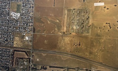
4th/19th Prince of Wales's Light Horse Regiment Unit History Room
Aerial Photographs, Broadmeadows Victoria camp?, late 1940's
... Aerial Photographs...A set of 30 aerial photographs of what could be Broadmeadows Victoria camp. ...The majority of the tanks appear to be General Grants Broadmeadows Victoria camp? Aerial Photographs ...A set of 30 aerial photographs of what could be Broadmeadows Victoria camp. Some show the terrain, others the camp layout and others of a tank regiment formed up in Squadrons. The majority of the tanks appear to be General Grantsairial photos, tank camp, broadmeadows