Showing 2842 items matching "aerials"
-
 National Vietnam Veterans Museum (NVVM)
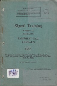
Booklet, British Army, British Army: Signal Training, Volume 2, Wireless Pamphlet No. 2, Aerials, 1956, 1956
... British Army: Signal Training, Volume 2, Wireless Pamphlet No. 2, Aerials, 1956......Aerials...British Army: Signal Training, Volume 2, Wireless Pamphlet No. 2, Aerials, 1956 Booklet British Army ...A blue coloured cardboard cover with black information on the front. Near the top right hand corner reads WO Code No: 9033. Near the bottom left hand corner there is a white label P181 and the 35 is corssed out. There are two metal staples and three punch holes down the left hand side. The booklet is covered with a plastic cover.british army, signal training, wireless, aerials -
 Moorabbin Air Museum
Manual (item) - Communications training aerials and propagation, Communications Aerials and Propagation
... Communications Aerials and Propagation...Moorabbin Air Museum Moorabbin Airport 12 First Street Moorabbin melbourne RAAF Technical Training Communications Aerials and Propagation Manual Communications training aerials and propagation ...RAAF Technical Training -
Moorabbin Air Museum
Administrative record (item) - ASTA Systems; Category 1 Approved Suppliers; Category 2 Approved Suppliers; Category 3 Approved Suppliers; Category 4 Approved Suppliers; Category 5 Approved Suppliers; Category 6 Approved Suppliers;Category 7 Approved Suppliers; Category 8 Approved Suppliers; Jindivik; Aerials; Alternators; Air Conditioners; Aluminium Extrusions; Batteries; Bonding Leads; Brass; Boxes & Racks; Cable Ties; Capacitors; Conduits & Fittings; Connectors; Connector Accessories; Copy Services; Specifiations; Bob Nash, ASTA Systems; Category 1 Approved Suppliers; Category 2 Approved Suppliers; Category 3 Approved Suppliers; Category 4 Approved Suppliers; Category 5 Approved Suppliers; Category 6 Approved Suppliers;Category 7 Approved Suppliers; Category 8 Approved Suppliers; Jindivik; Aerials; Alternators; Air Conditioners; Aluminium Extrusions; Batteries; Bonding Leads; Brass; Boxes & Racks; Cable Ties; Capacitors; Conduits & Fittings; Connectors; Connector Accessories; Copy Services; Specifications; Bob Nash
... ASTA Systems; Category 1 Approved Suppliers; Category 2 Approved Suppliers; Category 3 Approved Suppliers; Category 4 Approved Suppliers; Category 5 Approved Suppliers; Category 6 Approved Suppliers;Category 7 Approved Suppliers; Category 8 Approved Suppliers; Jindivik; Aerials; Alternators; Air Conditioners; Aluminium Extrusions; Batteries; Bonding Leads; Brass; Boxes & Racks; Cable Ties; Capacitors; Conduits & Fittings; Connectors; Connector Accessories; Copy Services; Specifications; Bob Nash...Moorabbin Air Museum Moorabbin Airport 12 First Street Moorabbin melbourne Red 3-ring Binder with stiff paper dividers ASTA Systems; Category 1 Approved Suppliers; Category 2 Approved Suppliers; Category 3 Approved Suppliers; Category 4 Approved Suppliers; Category 5 Approved Suppliers; Category 6 Approved Suppliers;Category 7 Approved Suppliers; Category 8 Approved Suppliers; Jindivik; Aerials; Alternators; Air Conditioners; Aluminium Extrusions; Batteries; Bonding Leads; Brass; Boxes & Racks; Cable Ties; Capacitors; Conduits & Fittings; Connectors; Connector Accessories; Copy Services; Specifications; Bob Nash Administrative record ASTA Systems; Category 1 Approved Suppliers; Category 2 Approved Suppliers; Category 3 Approved Suppliers; Category 4 Approved Suppliers; Category 5 Approved Suppliers; Category 6 Approved Suppliers;Category 7 Approved Suppliers; Category 8 Approved Suppliers; Jindivik; Aerials; Alternators; Air Conditioners; Aluminium Extrusions; Batteries; Bonding Leads; Brass; Boxes & Racks; Cable Ties; Capacitors; Conduits & Fittings; Connectors; Connector Accessories; Copy Services; Specifiations; Bob Nash ... -
Moorabbin Air Museum
Drawing (Item) - De Havilland Installation of ARC44 Aerials to Sioux Helicopter 10-H-17
... De Havilland Installation of ARC44 Aerials to Sioux Helicopter 10-H-17...Moorabbin Air Museum Moorabbin Airport 12 First Street Moorabbin melbourne De Havilland Installation of ARC44 Aerials to Sioux Helicopter 10-H-17 Drawing De Havilland Installation of ARC44 Aerials to Sioux Helicopter 10-H-17 ... -
 Sunbury Family History and Heritage Society Inc.
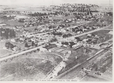
Photograph, 1936
... The aerial view of Sunbury was featured in The Argus newspaper in 1936 in recognition of 100 years of European settlement of the area. ...A non-digital black and white aerial photograph with a cream border of the Sunbury township. ...SUNBURY 1936 - A SOUVENIR AERIAL PHOTOGRAPH ISSUED BY THE ARGUS....Since the 1980s the area grown rapidly and is now an outer suburb of Melbourne. Aerial photographs Sunbury Newspaper photographs SUNBURY 1936 - A SOUVENIR AERIAL PHOTOGRAPH ISSUED BY THE ARGUS. ...The aerial view of Sunbury was featured in The Argus newspaper in 1936 in recognition of 100 years of European settlement of the area. It shows the extent of the township in 1936 which extended from the railway line in the west to the Jackson Creek in the east and the Sunbury Asylum in the south and northwards towards Macedon Street. The photograph was taken when Sunbury was a country settlement 25 miles ( 37 kms) from Melbourne. Since the 1980s the area grown rapidly and is now an outer suburb of Melbourne.A non-digital black and white aerial photograph with a cream border of the Sunbury township. SUNBURY 1936 - A SOUVENIR AERIAL PHOTOGRAPH ISSUED BY THE ARGUS.aerial photographs, sunbury, newspaper photographs -
 Sunshine and District Historical Society Incorporated
Photograph - Aerial Photographs of Sunshine 1946, 1946
... Copy of aerial photographs of Sunshine 1946...Aerial Photographs of Sunshine 1946 Collection of 8 black and white aerial photographs of Sunshine...Aerial Photograph Aerial Photographs of Sunshine 1946 Collection of 8 black and white aerial photographs of Sunshine Copy of aerial photographs of Sunshine 1946 Photograph Aerial Photographs of Sunshine 1946 ...Aerial Photographs of Sunshine 1946 Collection of 8 black and white aerial photographs of Sunshineaerial photograph -
 Bacchus Marsh & District Historical Society
Photograph, Aerial image of Bacchus Marsh and Darley in 1994
... Aerial image of Bacchus Marsh and Darley in 1994...A whole of town and nearby area aerial image of Bacchus Marsh produced for display in the Arbee Real Estate Agency premises in Main Street, Bacchus Marsh....A large framed colour aerial photograph showing the township of Bacchus Marsh, the neighbouring smaller community of Darley, and the nearby areas of both places. ..."Bacchus Marsh - Darley. Aerial Photo 27 November, 1994. Presented by Arbee Real Estate "Professionals"'...Aerial image of Bacchus Marsh and Darley in 1994 Photograph ...A whole of town and nearby area aerial image of Bacchus Marsh produced for display in the Arbee Real Estate Agency premises in Main Street, Bacchus Marsh.A large framed colour aerial photograph showing the township of Bacchus Marsh, the neighbouring smaller community of Darley, and the nearby areas of both places. "Bacchus Marsh - Darley. Aerial Photo 27 November, 1994. Presented by Arbee Real Estate "Professionals"'arbee real estate agency bacchus marsh, aerial views bacchus marsh vic. -
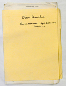 Orbost & District Historical Society
folder of documents, 1972
... The Club played a significant role in the establishment of the small airport at Marlo and in the ongoing operation and development of the airport over the years particularly for patient transfer by aerial ambulance. ...A manila folder containing applications for charter, aerial work and flying school licences....On front in black - ORBOST AERO CLUB CHARTER, AERIAL WORK & FLYING SCHOOL LICENCE APPLICATION ...Orbost-Aero-Club On front in black - ORBOST AERO CLUB CHARTER, AERIAL WORK & FLYING SCHOOL LICENCE APPLICATION A manila folder containing applications for charter, aerial work and flying school licences. folder of documents Orbost Aero Club ...Orbost Aero Club began in 1969 with Basil Dowie as Chair, David Nixon as Secretary/Treasurer. The group went into recess from 1977-1991 closing in 1997. The mid 1960s were boom years in flying training in Australia and the number of Aero Clubs grew rapidly. The Club played a significant role in the establishment of the small airport at Marlo and in the ongoing operation and development of the airport over the years particularly for patient transfer by aerial ambulance. The Orbost Aero Club Club played a significant role in the establishment of the small airport at Marlo and in the ongoing operation and development of the airport over the years. A manila folder containing applications for charter, aerial work and flying school licences.On front in black - ORBOST AERO CLUB CHARTER, AERIAL WORK & FLYING SCHOOL LICENCE APPLICATION orbost-aero-club -
 Phillip Island and District Historical Society Inc.
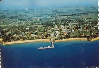
Photograph, 1960 - 1973
... Colour photograph - postcard - aerial view of Cowes..."Aerial view of Cowes"...Phillip Island and District Historical Society Inc. phillip-island-and-the-bass-coast One of a Postcard Series. local history newspapers aerial photograph cowes coloured photograph phillip island Jean Jamieson "Aerial view of Cowes" Colour photograph - postcard - aerial view of Cowes Photograph ...One of a Postcard Series.Colour photograph - postcard - aerial view of Cowes"Aerial view of Cowes"local history, newspapers, aerial photograph, cowes, coloured photograph, phillip island, jean jamieson -
Federation University Historical Collection
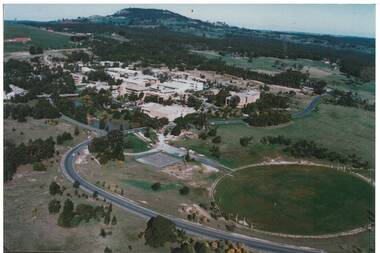
Photograph, Mount Helen Campus Aerial Views, 10/1983
... Mount Helen Campus Aerial Views......aerials...Aerial Photos of the Mount Helen Campus...Barker Library (top floor) Mount Helen goldfields buildings mount helen campus aerials Aerial Photos of the Mount Helen Campus Mount Helen Campus Aerial Views Photograph ...Aerial Photos of the Mount Helen Campusbuildings, mount helen campus, aerials -
Federation University Historical Collection
Photograph, Mount Helen Campus Aerial Views, 1984-1988
... Mount Helen Campus Aerial Views......aerials...Aerial Photos of the Mount Helen Campus...Barker Library (top floor) Mount Helen goldfields buildings mount helen campus aerials Aerial Photos of the Mount Helen Campus Mount Helen Campus Aerial Views Photograph ...Aerial Photos of the Mount Helen Campusbuildings, mount helen campus, aerials -
 Sunshine and District Historical Society Incorporated
Photograph - Sunshine Aerial Photograph 1972, 1972
... ... Aerial...Black & White Sunshine Aerial Photograph 1972...Sunshine Aerial Photograph 1972...Sunshine Aerial Club Aerial Photograph Photograph Sunshine Aerial Photograph 1972 Black & White Sunshine Aerial Photograph 1972 Photograph Sunshine Aerial Photograph 1972 ...Sunshine Aerial Photograph 1972sunshine aerial club, aerial, photograph photograph -
Glenelg Shire Council Cultural Collection
Photograph - Photograph - aerial view of railway between Heywood and Rennick, 03/05/1952
... Black and white aerial photographs (aerial survey record print) of the railway line between Heywood and Rennick (S.A. border) Taken for Victorian Railways, May 1952. ...Victorian Railways aerial survey record print of the railway line between Heywood and Rennick (S.A. border) Black and white, white vertical strip on image...Back: 'Heywood - Rennick 21389 - 19660 261m 3c ' - all black ink. Purple VR aerial survey stamp. '3 May 1952' - black stamp...Glenelg Shire Council Cultural Collection History House Cliff Street Portland great-ocean-road Black and white aerial photographs (aerial survey record print) of the railway line between Heywood and Rennick (S.A. border) Taken for Victorian Railways, May 1952. ...Black and white aerial photographs (aerial survey record print) of the railway line between Heywood and Rennick (S.A. border) Taken for Victorian Railways, May 1952. Some photos have annotations later added to the front of the image in penVictorian Railways aerial survey record print of the railway line between Heywood and Rennick (S.A. border) Black and white, white vertical strip on imageBack: 'Heywood - Rennick 21389 - 19660 261m 3c ' - all black ink. Purple VR aerial survey stamp. '3 May 1952' - black stampvictorian railways, train track, transport -
Glenelg Shire Council Cultural Collection
Photograph - Photograph - aerial view of train track between Heywood and Rennick, 03/05/1952
... Black and white aerial photographs (aerial survey record print) of the railway line between Heywood and Rennick (S.A. border) Taken for Victorian Railways, May 1952. ...Victorian Railways aerial survey record print of the railway line between Heywood and Rennick (S.A. border) Black and white, white vertical strip on image...Back: 'Heywood - Rennick 21453 - 19724 267m 19c ' - all black ink. Purple VR aerial survey stamp. '3 May 1952' - black stamp...Glenelg Shire Council Cultural Collection History House Cliff Street Portland great-ocean-road Black and white aerial photographs (aerial survey record print) of the railway line between Heywood and Rennick (S.A. border) Taken for Victorian Railways, May 1952. ...Black and white aerial photographs (aerial survey record print) of the railway line between Heywood and Rennick (S.A. border) Taken for Victorian Railways, May 1952. Some photos have annotations later added to the front of the image in penVictorian Railways aerial survey record print of the railway line between Heywood and Rennick (S.A. border) Black and white, white vertical strip on imageBack: 'Heywood - Rennick 21453 - 19724 267m 19c ' - all black ink. Purple VR aerial survey stamp. '3 May 1952' - black stampvictorian railways, train track, transport, travel -
 Sunshine and District Historical Society Incorporated
Photograph - Early aerial photograph of ICI
... An early aerial photograph of ICI...Aerial shot of land and buildings on the ICI site...ICI Deer Park Aerial Photograph Aerial shot of land and buildings on the ICI site An early aerial photograph of ICI Photograph Early aerial photograph of ICI ...Aerial shot of land and buildings on the ICI siteici, deer park, aerial photograph -
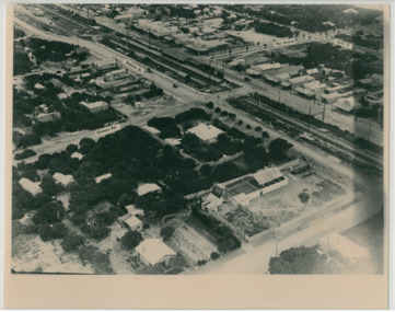
![Photograph - Aerial view of Sunshine, [1970s]](/media/collectors/5164c1772162ef0c64d700f2/items/69dc57946a5a9c1cb356d9b3/item-media/69dc597c6a5a9c1cb356eecf/item-fit-380x285.jpg?cb=6) Sunshine and District Historical Society Incorporated
Sunshine and District Historical Society IncorporatedPhotograph - Aerial view of Sunshine, [1970s]
... Aerial view of Sunshine...Aerial view of Sunshine business and residential district including railway line...Sunshine Overpass Bridge Hampshire Road Aerial view of Sunshine business and residential district including railway line Aerial view of Sunshine Photograph Aerial view of Sunshine ...Aerial view of Sunshine business and residential district including railway linesunshine, overpass, bridge, hampshire road -
Glenelg Shire Council Cultural Collection
Photograph - Photograph - aerial view of train track between Heywood and Rennick, 03/05/1952
... Black and white aerial photographs (aerial survey record print) of the railway line between Heywood and Rennick (S.A. border) Taken for Victorian Railways, May 1952. ...Victorian Railways aerial survey record print of the railway line between Heywood and Rennick (S.A. border) Black and white, white vertical strip on image...Front: Annotations in red ink added at a later date Back: 'Heywood - Rennick 21579 - 19842 279m 57c ' - all black ink. Purple VR aerial survey stamp. '3 May 1952' - black stamp...Glenelg Shire Council Cultural Collection History House Cliff Street Portland great-ocean-road Black and white aerial photographs (aerial survey record print) of the railway line between Heywood and Rennick (S.A. border) Taken for Victorian Railways, May 1952. ...Black and white aerial photographs (aerial survey record print) of the railway line between Heywood and Rennick (S.A. border) Taken for Victorian Railways, May 1952. Some photos have annotations later added to the front of the image in penVictorian Railways aerial survey record print of the railway line between Heywood and Rennick (S.A. border) Black and white, white vertical strip on imageFront: Annotations in red ink added at a later date Back: 'Heywood - Rennick 21579 - 19842 279m 57c ' - all black ink. Purple VR aerial survey stamp. '3 May 1952' - black stampvictorian railways, train track, transport, travel -
 Chelsea & District Historical Society Inc
Photograph - Aerial Photo of Chelsea, c 1923
... Mr William Herbert Hansom was a pioneer of aerial photography in Australia....Black and white aerial photo of Chelsea, bordered by Thames Promenade, Balantyne Avenue, Catherine Avenue and Chelsea Road, Station Street, The Strand, Bath Street....Hansom ("Manders") Aerial Artist, Personally Conducted Flights over Melbourne and Suburbs St James' Building Bourke Street, Melbourne...Photograph Aerial Photo of Chelsea ...Points of interest in the photo are Fox Theatre, Chelsea Railway Station and the building site of Masons Theatre on the corner of Chelsea Road and Station Street. Mr William Herbert Hansom was a pioneer of aerial photography in Australia.Black and white aerial photo of Chelsea, bordered by Thames Promenade, Balantyne Avenue, Catherine Avenue and Chelsea Road, Station Street, The Strand, Bath Street.W. H. Hansom ("Manders") Aerial Artist, Personally Conducted Flights over Melbourne and Suburbs St James' Building Bourke Street, Melbournechelsea, aerial photo, station street, chelsea road, the strand, bath street, fox theatre, masons theatre, w. h. hansom, chelsea railway station -
Glenelg Shire Council Cultural Collection
Photograph - aerial view of train track between Heywood and Rennick, 03/05/1952
... Black and white aerial photographs (aerial survey record print) of the railway line between Heywood and Rennick (S.A. border) Taken for Victorian Railways, May 1952. ...Victorian Railways aerial survey record print of the railway line between Heywood and Rennick (S.A. border) Black and white, white vertical strip on image...Front: Annotations in red ink added at a later date Back: 'Heywood - Rennick 21578 - 19841 279m 49c Rennick ' - all black ink. Purple VR aerial survey stamp. '3 May 1952' - black stamp...Glenelg Shire Council Cultural Collection History House Cliff Street Portland great-ocean-road Black and white aerial photographs (aerial survey record print) of the railway line between Heywood and Rennick (S.A. border) Taken for Victorian Railways, May 1952. ...Black and white aerial photographs (aerial survey record print) of the railway line between Heywood and Rennick (S.A. border) Taken for Victorian Railways, May 1952. Some photos have annotations later added to the front of the image in penVictorian Railways aerial survey record print of the railway line between Heywood and Rennick (S.A. border) Black and white, white vertical strip on imageFront: Annotations in red ink added at a later date Back: 'Heywood - Rennick 21578 - 19841 279m 49c Rennick ' - all black ink. Purple VR aerial survey stamp. '3 May 1952' - black stampvictorian railways, train track, travel, transport -
 Lakes Entrance Historical Society
Postcard - Omeo Victoria c1940, H D Bulmer
... Black and white postcard showing an aerial view of the roads and country surrounding the mining town of Omeo Victoria...Aerial view of Omeo...Lakes Entrance Historical Society 4 Marine Parade Lakes Entrance gippsland Hotels Transport Aerial view of Omeo Black and white postcard showing an aerial view of the roads and country surrounding the mining town of Omeo Victoria Postcard Omeo Victoria c1940 H D Bulmer ...Black and white postcard showing an aerial view of the roads and country surrounding the mining town of Omeo VictoriaAerial view of Omeohotels, transport -
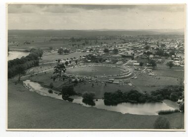 Orbost & District Historical Society
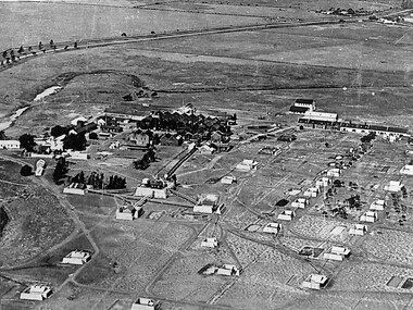
black and white photographs, March 10 1961
... Four black / white aerial photographs. there are spare copies of each. 3276.1 is an aerial photograph of the Orbost Show with Lochiel Park in the foreground. 3276.2 is an aerial photograph taken over a township. 3276.3 shows the Orbost High School on the left. 3276,4 shows the high school in the foreground....on the back of each is "March 10th 1961 Aerial of Orbost"...They are useful for reference. photographs-aerial-Orbost-1961 Orbost-1961 Lochiel-Park on the back of each is "March 10th 1961 Aerial of Orbost" Four black / white aerial photographs. there are spare copies of each. 3276.1 is an aerial photograph of the Orbost Show with Lochiel Park in the foreground. 3276.2 is an aerial photograph taken over a township. 3276.3 shows the Orbost High School on the left. 3276,4 shows the high school in the foreground. black and white photographs ...These photographs are pictorial record of Orbost in 1961.They enable us o observe the objects in their spatial context and in detail. They are useful for reference.Four black / white aerial photographs. there are spare copies of each. 3276.1 is an aerial photograph of the Orbost Show with Lochiel Park in the foreground. 3276.2 is an aerial photograph taken over a township. 3276.3 shows the Orbost High School on the left. 3276,4 shows the high school in the foreground.on the back of each is "March 10th 1961 Aerial of Orbost"photographs-aerial-orbost-1961 orbost-1961 lochiel-park -
Glenelg Shire Council Cultural Collection
Photograph - Photograph - aerial view of Portland harbour, 1960
... Black and white aerial view of harbour....Front: Harbour: Aerial view south. July '60 - typed, bottom....July '60 - typed, bottom. Black and white aerial view of harbour. Photograph Photograph - aerial view of Portland harbour ...Port of Portland AuthorityFront: Harbour: Aerial view south. July '60 - typed, bottom.port of portland archives, aerial photography, portland harbour -
Glenelg Shire Council Cultural Collection
Photograph - Photograph - aerial view of the train track between Heywood and Rennick, 03/05/1952
... Black and white aerial photographs (aerial survey record print) of the railway line between Heywood and Rennick (S.A. border) Taken for Victorian Railways, May 1952. ...Victorian Railways aerial survey record print of the railway line between Heywood and Rennick (S.A. border) Black and white, white vertical strip on image...White sticker, black print 'Rennick' Purple VR aerial survey stamp. '3 May 1952' - black stamp...Glenelg Shire Council Cultural Collection History House Cliff Street Portland great-ocean-road Black and white aerial photographs (aerial survey record print) of the railway line between Heywood and Rennick (S.A. border) Taken for Victorian Railways, May 1952. ...Black and white aerial photographs (aerial survey record print) of the railway line between Heywood and Rennick (S.A. border) Taken for Victorian Railways, May 1952. Some photos have annotations later added to the front of the image in penVictorian Railways aerial survey record print of the railway line between Heywood and Rennick (S.A. border) Black and white, white vertical strip on imageFront: Annotations in red ink added at a later date Back: 'Heywood - Rennick 21577 - 19840 279m 41c ' - all black ink. White sticker, black print 'Rennick' Purple VR aerial survey stamp. '3 May 1952' - black stampvictorian railways, travel, train, transport -
 Sunshine and District Historical Society Incorporated
Photograph - Sunshine Aerial Photograph 9th January 1968
... ... Aerial...2 Black & White Sunshine Aerial Photographs dated 9th January 1968...Sunshine Aerial Photograph 9th January 1968...Sunshine Aerial Club Aerial Photograph Photograph Sunshine Aerial Photograph 9th January 1968 2 Black & White Sunshine Aerial Photographs dated 9th January 1968 Photograph Sunshine Aerial Photograph 9th January 1968 ...Sunshine Aerial Photograph 9th January 1968sunshine aerial club, aerial, photograph photograph -
 Buninyong & District Historical Society
Photograph - Colour Photograph of Mt Helen Campus, Aerial view of University of Ballarat, Mt. Helen Campus c1991
... Aerial view of University of Ballarat, Mt. Helen Campus c1991...Aerial view Mount Helen Campus c1991...Mt. Helen Campus. Aerial view to Mt. Buninyong c. 1991...Helen Campus Tertiary Education Mount Buninyong Rural Development Mt. Helen Campus. Aerial view to Mt. Buninyong c. 1991 Aerial view Mount Helen Campus c1991 Aerial view of University of Ballarat, Mt. ...Mount Helen Campus in its later building stages before becoming the University of Ballarat in 1994The University of Ballarat was formed from a number of varying types of tertiary schools, the earliest being the School of Mines in 1870 and finally became a University in 1994 Aerial view Mount Helen Campus c1991Mt. Helen Campus. Aerial view to Mt. Buninyong c. 1991university of ballarat, mt. helen campus, tertiary education, mount buninyong, rural development -
 Lakes Entrance Historical Society
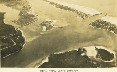
Postcard - Aerial view Lakes Entrance c1922, H D Bulmer, Roadnight Collection Postcards, 1922 c
... Black and white postcard aerial view of the western area of the town, Bullock Island and Snake Island and waterways Lakes Entrance Victoria...Aerial View Lakes Entrance...Image clearly shows new alignment of Princes Highway around Jemmys Point and part of the original high road to the first bend above North Arm Bridge Waterways Islands Township Aerial View Lakes Entrance Black and white postcard aerial view of the western area of the town, Bullock Island and Snake Island and waterways Lakes Entrance Victoria Roadnight Collection Postcards Postcard Aerial view Lakes Entrance c1922 H D Bulmer ...Image clearly shows new alignment of Princes Highway around Jemmys Point and part of the original high road to the first bend above North Arm BridgeBlack and white postcard aerial view of the western area of the town, Bullock Island and Snake Island and waterways Lakes Entrance VictoriaAerial View Lakes Entrancewaterways, islands, township -
 Camberwell Historical Society
Photograph, Camberwell Victoria, aerial view of the District, c. 1940
... Camberwell Victoria, aerial view of the District...Print of photograph with inscription 'Camberwell Victoria, aerial view of the District, c. 1940' ...Camberwell Victoria, aerial view of the District, c. 1940...Camberwell Historical Society 25 Inglesby Road Camberwell melbourne Camberwell Camberwell Victoria, aerial view of the District, c. 1940 Print of photograph with inscription 'Camberwell Victoria, aerial view of the District, c. 1940' Camberwell Victoria, aerial view of the District Photograph Photograph ...Print of photograph with inscription 'Camberwell Victoria, aerial view of the District, c. 1940' Camberwell Victoria, aerial view of the District, c. 1940camberwell -
4th/19th Prince of Wales's Light Horse Regiment Unit History Room
Mast Aerial Gear No 2 Mk II, Kit Aerial Vertical 34 Feet Steel (Aust), 1953 (case)
... Kit Aerial Vertical 34 Feet Steel (Aust)...A canvas carrying bag containing the mast sections, aerial base etc, complete with case containing No 1 antenna rods 'F'...Kits Aerial Z1/ZAA 0050, Bag Aerial Gear MkII ZA0437, Case Carrying ZA 1101...4th/19th Prince of Wales's Light Horse Regiment Unit History Room 4/19 PWLH Regiment, Building 78 Simpson Barracks Macleod melbourne Mast 34 foot antenna Kits Aerial Z1/ZAA 0050, Bag Aerial Gear MkII ZA0437, Case Carrying ZA 1101 A canvas carrying bag containing the mast sections, aerial base etc, complete with case containing No 1 antenna rods 'F' Kit Aerial Vertical 34 Feet Steel (Aust) Mast Aerial Gear No 2 Mk II MH & Co ...A canvas carrying bag containing the mast sections, aerial base etc, complete with case containing No 1 antenna rods 'F'Kits Aerial Z1/ZAA 0050, Bag Aerial Gear MkII ZA0437, Case Carrying ZA 1101mast 34 foot, antenna -
 St Kilda Historical Society
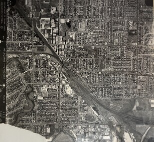
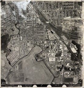
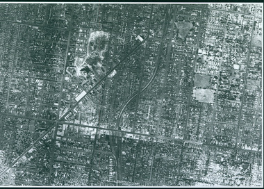
Photograph - Photo map, 13/01/1968
... Black and white aerial photograph...2138 State Aerial Survey Melbourne 1968 Proj. Run 26 13.1.68 5100 ASL 203...For correlation with a current map, and access to other historical photo maps of Victoria, see the Historic Photo-Maps Index published by the Department of Environment, Land, Water and Planning at https://services.land.vic.gov.au/DELWPmaps/historical-photomaps/ St Kilda West Albert Park Fawkner Park South Yarra Prahran Windsor 1968 2138 State Aerial Survey Melbourne 1968 Proj. Run 26 13.1.68 5100 ASL 203 Black and white aerial photograph Photograph Photo map ...One of a series of photo-maps produced for the Department of Crown Lands and Survey (1857-1983). For correlation with a current map, and access to other historical photo maps of Victoria, see the Historic Photo-Maps Index published by the Department of Environment, Land, Water and Planning at https://services.land.vic.gov.au/DELWPmaps/historical-photomaps/Black and white aerial photograph2138 State Aerial Survey Melbourne 1968 Proj. Run 26 13.1.68 5100 ASL 203st kilda west, albert park, fawkner park, south yarra, prahran, windsor, 1968 -
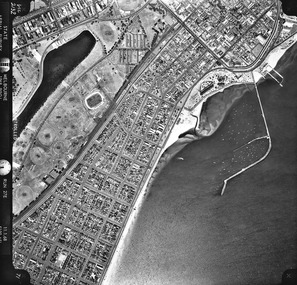 St Kilda Historical Society
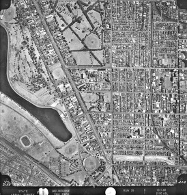
Photograph - Photo map, 11/01/1968
... Black and white aerial photograph...Vic 2132 State Aerial Survey Melbourne 1968 Proj. Run 27E 11.1.68 5100 ASL...For correlation with a current map, and access to other historical photo maps of Victoria, see the Historic Photo-Maps Index published by the Department of Environment, Land, Water and Planning at https://services.land.vic.gov.au/DELWPmaps/historical-photomaps/ St Kilda St Kilda West St Kilda Pier Catani Gardens St Kilda Beach Albert Park 1968 Vic 2132 State Aerial Survey Melbourne 1968 Proj. Run 27E 11.1.68 5100 ASL Black and white aerial photograph Photograph Photo map ...One of a series of photo-maps produced for the Department of Crown Lands and Survey (1857-1983). For correlation with a current map, and access to other historical photo maps of Victoria, see the Historic Photo-Maps Index published by the Department of Environment, Land, Water and Planning at https://services.land.vic.gov.au/DELWPmaps/historical-photomaps/Black and white aerial photographVic 2132 State Aerial Survey Melbourne 1968 Proj. Run 27E 11.1.68 5100 ASLst kilda, st kilda west, st kilda pier, catani gardens, st kilda beach, albert park, 1968