Showing 4 items matching "altona bus lines"
-
 Sunshine and District Historical Society Incorporated
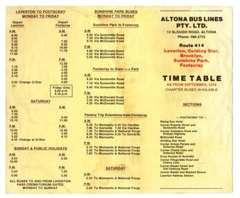
Memorabilia - Route 414 Altona Bus Lines Timetable 1979
... Route 414 Altona Bus Lines Timetable 1979......Altona Bus Lines...Altona Bus Lines Pty Ltd began as a western‑suburbs family bus operator and entered public passenger transport in 1976 with the purchase of Point Cook – Werribee Passenger Service (Blue Riband). ...1979 Paper timetable for the Route 414 Altona Bus Lines...Altona Bus Lines Pty Ltd 15 Slough Road, Alto Phone 398-2712 Route Guiding Star Laverton Brooklyn Sunshine Park Footscray Time Table as from September 1979 Charter Buses Available...Altona Bus Lines Pty Ltd began as a western‑suburbs family bus operator and entered public passenger transport in 1976 with the purchase of Point Cook – Werribee Passenger Service (Blue Riband). ...Altona Bus Lines Pty Ltd began as a western‑suburbs family bus operator and entered public passenger transport in 1976 with the purchase of Point Cook – Werribee Passenger Service (Blue Riband). The company later became part of the Kefford Corporation, which was ultimately absorbed into CDC Victoria (ComfortDelGro Australia). The company name Altona Bus Lines Pty Ltd survives only as a historic trading name under the corporate entity now known as CDC Altona Pty Ltd. The company provided services to many different locations throughout the Western Suburbs with this route designed for workers to go factories in McDonald Road, Somerville Road, etc.Altona Bus Lines Pty Ltd 15 Slough Road, Alto Phone 398-2712 Route Guiding Star Laverton Brooklyn Sunshine Park Footscray Time Table as from September 1979 Charter Buses Availabletransport, altona bus lines, blue riband -
 Melbourne Tram Museum
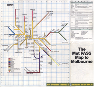
Map, The Met, "The Met PASS Map to Melbourne", c1988/90
... lines to Light Rail, though these are not shown. Opened November 1987. Rail Map - shows Route 96 north section as Light Rail, co-ordinated bus routes, and the Altona line as going to Werribee. ...lines to Light Rail, though these are not shown. Opened November 1987. Rail Map - shows Route 96 north section as Light Rail, co-ordinated bus routes, and the Altona line as going to Werribee. ...Folded Map of Melbourne Rail and Tram lines, titled "The Met PASS Map to Melbourne" Tram Map - probably soon after conversion of the St Kilda and Port Melbourne lines to Light Rail, though these are not shown. Opened November 1987. Rail Map - shows Route 96 north section as Light Rail, co-ordinated bus routes, and the Altona line as going to Werribee. This route was opened in 1985. Date of Map c1988/1990. Has details of Museums, Art Galleries, Shopping, Gardens and Sports Arenas. See also Reg Item 379 for a similar item.trams, tramways, the met, melbourne, maps, tourist tickets -
 Melbourne Tram Museum
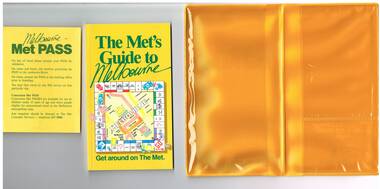
Book, The Met, "Met Pass", late 1980's
... lines to Light Rail, though these are not shown. Opened November 1987. Rail Map - shows Route 96 north section as Light Rail, co-ordinated bus routes, and the Altona line as going to Werribee. ...lines to Light Rail, though these are not shown. Opened November 1987. Rail Map - shows Route 96 north section as Light Rail, co-ordinated bus routes, and the Altona line as going to Werribee. ...Yellow plastic folder titled "Melbourne Met Pass", with The Met logo in green print on both sides of the outside of the folder. On the inside has two pockets for storing items formed with clear plastic. Map Folded Map of Melbourne Rail and Tram lines, titled "The Met PASS Map to Melbourne" Tram Map - probably soon after conversion of the St Kilda and Port Melbourne lines to Light Rail, though these are not shown. Opened November 1987. Rail Map - shows Route 96 north section as Light Rail, co-ordinated bus routes, and the Altona line as going to Werribee. This route was opened in 1985. Date of Map c1988/1990. Has details of Museums, Art Galleries, Shopping, Gardens and Sports Arenas in Japanese. Sheet of paper advising users on presentation of the Met Pass (not included in the folder) Book - titled "The Met's Guide to Melbourne", sub titled - Get around on The Met. Card covers, perfect bound, 100 pages in colour with maps, guides and information about various locations within Greater Melbourne including Werribee Zoo and Healesville. See also Reg Item 106 to 108 for a similar item and 983 for the document that was used to launch the Met Pass. Two copies held.trams, tramways, the met, melbourne, tickets, tourist tickets -
 Melbourne Tram Museum
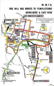
Map, Melbourne & Metropolitan Tramways Board (MMTB), Set of 8 bus route maps, 1977 to 1979
... bus or groups of tram lines for the MMTB. Some have the Transport Information Centre telephone printed on them, others have a label stuck on. Some are finished with a plastic laminate finish on either one or both sides. Show the major cross streets, parks, schools, other tram routes, major stop numbers and railway lines. .1 - Box Hill bus routes to Templestowe - R38/82, Heidelberg and East Kew, includes Doncaster, Shoppingtown and Newmans Road. .2 - Clifton Hill - R2/79 - Elsternwick, Point Ormond and St Kilda Junction .3 - Footscray, Sunshine, Deer Park, Nth Altona, Fishermen's Bend, Highpoint and Williamstown Road - R2/79. .4 - Bulleen - City - Port Melbourne - Garden City Bus Route, including Kew, Collingwood - R6/78 .5 - City - Warrandyte and East Doncaster including Newmans Road, Templestowe, East Doncaster, Donvale, Shopping town, and Kew. ...Melbourne Tram Museum 8 Wallen Road Hawthorn melbourne Trams tramways Maps Route Guide Route Numbers Routes Buses Box Hill Templestowe Doncaster East Kew Heidelberg Clifton Hill Point Ormond Elsternwick Footscray Sunshine Deer Park North Altona Fishermen's Bend Highpoint Williamstown Rd Bulleen Kew Collingwood Port Melbourne Garden City Warrandyte Donvale La Trobe University Northland Ringwood Park Orchards Mitcham Blackburn Geelong Series of colour route maps for various bus or groups of tram lines for the MMTB. ...Series of colour route maps for various bus or groups of tram lines for the MMTB. Some have the Transport Information Centre telephone printed on them, others have a label stuck on. Some are finished with a plastic laminate finish on either one or both sides. Show the major cross streets, parks, schools, other tram routes, major stop numbers and railway lines. .1 - Box Hill bus routes to Templestowe - R38/82, Heidelberg and East Kew, includes Doncaster, Shoppingtown and Newmans Road. .2 - Clifton Hill - R2/79 - Elsternwick, Point Ormond and St Kilda Junction .3 - Footscray, Sunshine, Deer Park, Nth Altona, Fishermen's Bend, Highpoint and Williamstown Road - R2/79. .4 - Bulleen - City - Port Melbourne - Garden City Bus Route, including Kew, Collingwood - R6/78 .5 - City - Warrandyte and East Doncaster including Newmans Road, Templestowe, East Doncaster, Donvale, Shopping town, and Kew. R3/82. .6 - West Heidelberg, La Trobe University, Northland - R3/81 .7 - Box Hill, Ringwood to East Doncaster and Warrandyte, Park Orchards, North Blackburn R3/82. .8 - Geelong - Herne Hill, Rollins Road, Donnybrook Rd, North Shore and Corio Villagetrams, tramways, maps, route guide, route numbers, routes, buses, box hill, templestowe, doncaster, east kew, heidelberg, clifton hill, point ormond, elsternwick, footscray, sunshine, deer park, north altona, fishermen's bend, highpoint, williamstown rd, bulleen, kew, collingwood, port melbourne, garden city, warrandyte, donvale, la trobe university, northland, ringwood, park orchards, mitcham, blackburn, geelong