Showing 194 items matching atlases
-
 Victorian Aboriginal Corporation for Languages
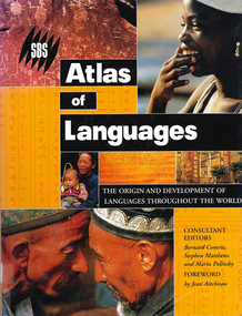
Book, Bernard Comrie, SBS SBS atlas of languages : the origin and development of languages throughout the world, 2003
... atlases ...Over 30 full-colour maps, over 40 of the world?s major languages, language family trees, over 100 stunning full-colour photographs. A full glossary of linguistic terms.Maps, colour illustrations, colour photographslinguistics, maps, atlases -
 Victorian Aboriginal Corporation for Languages
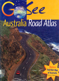
Book, Valerie Marlborough, Go see Australia road atlas, 2000
... atlases ...Contains state by state maps and details about each state.Maps, colour photographsatlases, road maps, australian travel -
 Robin Boyd Foundation
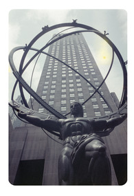
Slide, Robin Boyd, 1956-1957
Robin Boyd developed a close friendship with the founder of the Bauhaus in Weimar Germany, Walter Gropius, who had moved to the USA in the 1930s. Through this connection, Boyd was invited to be the Massachusetts Institute of Technology (MIT) Bemis Professor at the School in the North American academic year 1956-7. Robin and Patricia Boyd, with their youngest daughter Suzy, were based in Cambridge, Massachusetts for the year. Boyd gave some lectures at MIT and he was also invited to give lectures at many other universities, allowing him to travel widely within the USA, especially on the East Coast. This gave him the opportunity to meet architects like Frank Lloyd Wright, Eero Saarinen, Paul Rudolph and many others, and visit the offices of Skidmore, Owings and Merrill, and places like Taliesin and the General Motors Technical Center Detroit. On the way home, the Boyds visited London, Berlin, Paris and Le Corbusier’s Ronchamp Chapel in France.Colour slide in a mount. Lee Lawrie's 'Atlas' statue (1937) at the Rockefeller Center, New York City, New York, USA 04819/ D (Handwritten)mit bemis professorship, mit, robin boyd, slide -
 Kiewa Valley Historical Society
Maps of Victoria
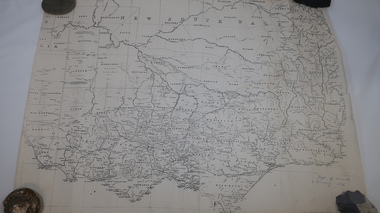
Three maps: copies from the 19th century. 1. Handwritten 'Dept of Lands & Survey 1876'. 2. Map of the Ovens & Murray District, Victoria with handwritten 'F.H. Hiscock & Co's, New Victoria Countries Atlas 1874'. 3. Map of the Murray and Gipps Land Distr' with handwritten: "Baillieu's County Atlas of Victoria 1866'.maps of victoria, 19th century, oven and murray district of victoria -
 Port Fairy Historical Society Museum and Archives
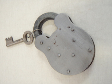
Functional object - Padlock
Metal Lock and KeyBritish Made 2 Lever Inscription CE Atlas 2Lever IB22padlock, security -
 Flagstaff Hill Maritime Museum and Village
Book, A Descriptive Atlas of the Eucalypts of Australia
Warrnambool's Mechanics' Institute (or Institution as it was sometimes called) was one of the earliest in Victoria. On 17th October 1853 a meeting was held where it was resolved to request the Lieutenant Governor of the Colony to grant land for the erection of a Mechanics' Institutes building. A committee was formed at the meeting and Richard Osburne chaired the first meeting of this committee. The land on the North West corner of Banyan and Merri Streets was granted but there were no funds to erect the building. The Formal Rights of the Warrnambool Mechanics' Institute's encompassed its aims and these were officially adopted in1859; "This Institution has for its object the diffusion of literary, scientific, and other useful knowledge amongst its members, excluding all controversial subjects, religious or political. These objects are sought to be obtained by means of a circulating library, a reading room, the establishment of classes, debates, and the occasional delivery of lectures on natural and experimental philosophy, mechanics, astronomy, chemistry, natural history, literature, and the useful and ornamental arts, particularly those which have a more immediate reference to the colony." The Warrnambool Mechanics' Institute opened its first reading room in November1884 in the National School building at the corner of Banyan and Timor Streets. The Institute was funded by member subscription, payable on a quarterly, half yearly or yearly basis. Samuel Hannaford, the Manager of the Warrnambool Bank of Australasia, was the first Honorary Secretary of the Mechanics' Institutes, and an early President and Vice-President. He also gave several of the early lectures in the Reading Room. Another early Secretary, Librarian and lecturer was Marmaduke Fisher, the teacher at the National School. Lecture topics included The Poets and Poetry of Ireland', 'The Birth and Development of the Earth', 'The Vertebrae - with Remarks on the pleasures resulting from the study of Natural History' and 'Architecture'. In 1856 the Reading Room was moved to James Hider's shop in Timor Street, and by 1864 it was located in the bookshop of Davies and Read. In the 1860's the Mechanics' Institute struggled as membership waned but in 1866, after a series of fund raising efforts, the committee was able to purchase land in Liebig Street, on a site then called Market Square, between the weighbridge and the fire station. A Mechanics' Institute building was opened at this site in August 1871. The following year four more rooms were added to the main Reading Room and in 1873 the Artisan School of Design was incorporated into the Institute. The same year Joseph Archibald established a Museum; however it deteriorated when he was transferred to Bendigo in 1877. In 1880, with Archibald's return to Warrnambool, the Museum was re-established, and in 1885 a new building was built at the back of the Institute to accommodate the re-created School of Design, the Art Gallery and the Museum. In 1887 the Museum section was moved to the former court house in Timor Street (for some time the walls of the building formed part of the TAFE cafeteria but all is now demolished)). In 1911 the Museum was transferred back to the original building and the management of the Mechanics' Institute was handed over to the Warrnambool City Council. The Museum and Art Gallery became one and housed many fine works of art, and the Library continued to grow. The building was well patronised, with records showing that at the beginning of the 20th century there were between 500 and 800 visitors. During World War One the monthly figures were in the thousands, with 3,400 people visiting in January 1915. The Museum was a much loved Institution in Warrnambool until the contents of the Museum and Art Gallery were removed to make room for the Warrnambool City Council Engineers' Department. The contents were stored but many of the items were scattered or lost. When the original building was demolished the site became occupied by the Civic Centre, which included the new City Library. (The library was temporarily located in the old Palais building in Koroit Street.) In the process of reorganisation the Collection was distributed amongst the community groups: -The new City Library took some of the historic books and some important documents, historic photographs and newspapers. -The Art Gallery kept the 19th Century art collection and some of the artefacts from the museum. -The Historic Society has some items -The State Museum has some items -Some items were destroyed -Flagstaff Hill Maritime Village has old newspapers, Government Gazettes, most of the Mechanics' Institute Library, ledgers and documents connected to the Mechanics' Institute Library, some framed and unframed art works and some photographs. The Warrnambool Mechanics' Institute Library book collection is deemed to be of great importance because it is one of the few collections in an almost intact state, and many of the books are now very rare and of great value. A Descriptive Atlas of the Eucalypts of Australia and the adjoining Islands Author: Ferdinand Von Mueller Publisher: Government Printer Melbourne Date: 1879-1884 Label on spine cover with typed text RA 583.4 VONM Pastedown front endpaper has sticker from Warrnambool Mechanics Institute and Free Librarywarrnambool, shipwrecked-coast, flagstaff-hill, flagstaff-hill-maritime-museum, maritime-museum, shipwreck-coast, flagstaff-hill-maritime-village, shipwrecked-artefact, great ocean road, book, warrnambool library, warrnambool mechanics’ institute, mechanics’ institute library, victorian library board, warrnambool books and records, warrnambool children’s library, warrnambool public library, a descriptive atlas of the eucalypts of australia, a descriptive atlas of the eucalypts of australia and the adjoining islands, ferdinand von mueller -
 Eltham District Historical Society Inc
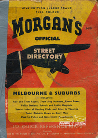
Book, Val Morgan and Sons Pty Ltd, Morgan's Street Directory of Melbourne & Suburbs, 42nd edition (large scale) (published 1965), 1965c
1 atlas (228 p.) : 147 col. maps ; 25 cm. (Two copies - second copy front and back covers separated/loose)melbourne maps, street directory -
 Tennis Australia
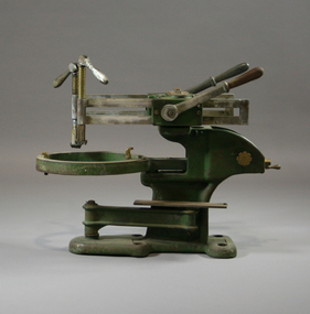
Stringing machine, Circa 1930
A small, tennis racquet stringing machine, with a detachable tensioner component. Inscription: ATLAS CO./LONDON/E...S/PATENT. Materials: Metal, Painttennis -
 Whitehorse Historical Society Inc.
Document, Fire Insurance Policy, 10/12/1909 12:00:00 AM
Fire insurance policy certificate issued to Martha Edwards for a building in Husband Road Tunstall, 10 December 1909, by Atlas Assurance Company Limited.Fire insurance policy certificate issued to Martha Edwards for a building in Husband Road Tunstall, 10 December 1909, by Atlas Assurance Company Limited.Fire insurance policy certificate issued to Martha Edwards for a building in Husband Road Tunstall, 10 December 1909, by Atlas Assurance Company Limited.edwards, martha, atlas assurance company limited, insurance, husband road, forest hill, no. 42, husband road, tunstall -
 Ballarat Heritage Services
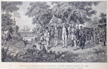
Work on paper - Image, Captain Cook Proclaiming New South Wales and British Possession, Botany Bay, 1770
First Published in Picturesque Atlas of Australia.Line drawing of Captain James Cook landing at Botany Bay, New South Wales.captain cook, james cook, botany bay, endeavour -
 Ballarat Heritage Services
Image, Captain James Cook
First Published in Picturesque Atlas of Australia.Line drawing of Captain James Cook.captain cook, james cook, botany bay, endeavour, explorer -
 Ballarat Heritage Services
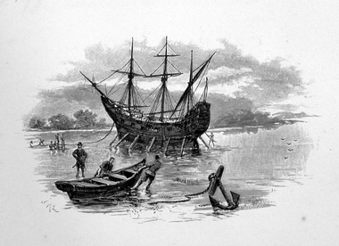
Image, Anchored Ship
First Published in Picturesque Atlas of Australia.Line drawing of a ship anchored on the coast.ship, exploration, immigration -
Ballarat Heritage Services
Image, Lord Carrington, c1886
First Published in Picturesque Atlas of Australia. Line drawing of Lord Carrington. portrait, lord carrington -
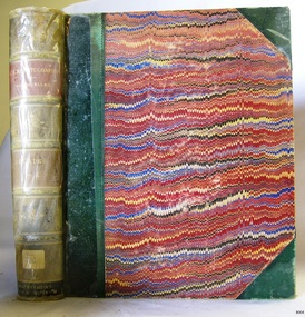
 Marysville & District Historical Society
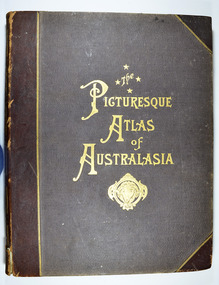
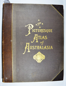
Book - Hardcover book, Picturesque Atlas Publishing Company Limited, The Picturesque Atlas of Australasia-Volume 2, 1886
The Picturesque Atlas of Australasia-Volume 2Hardcover. Cover is brown with the title in gold lettering. Underneath the title is a symbol of a solid wreath surrounding the head of a ram. Three fold-out maps are included; Railway Postal and Telegraph Map of South Australia, 1888; Railway Postal & Telegraph Map of Queensland, 1888; Railway, Postal, Telegraph and Rainfall Map of Tasmania 1889. non-fictionThe Picturesque Atlas of Australasia-Volume 2atlas, australasia, history -
 Marysville & District Historical Society
Book - Hardcover book, Picturesque Atlas Publishing Company Limited, The Picturesque Atlas of Australasia-Volume 3, 1886
The Picturesque Atlas of Australasia-Volume 3Hardcover. Cover is brown with the title in gold lettering. Underneath the title is a symbol of a solid wreath surrounding the head of a ram. A fold-out map is included; Railway Postal and Telegraph Map of the North Island of New Zealand, 1889. non-fictionThe Picturesque Atlas of Australasia-Volume 3atlas, australasia, history -
 Marysville & District Historical Society
Book - Hardcover book, Picturesque Atlas Publishing Company Limited, The Picturesque Atlas of Australasia-Volume 1, 1886
The Picturesque Atlas of Australasia-Volume 1Hardcover. Cover is brown with the title in gold lettering. Underneath the title is a symbol of a solid wreath surrounding the head of a ram.non-fictionThe Picturesque Atlas of Australasia-Volume 1atlas, australasia, history -
Port Melbourne Historical & Preservation Society
Photograph - Double-sided aerial photograph, Hobson's Bay and the Yarra River/Port Phillip and Western Port Bay, Surveyor General and Director of Mapping, Apr 1990
Landsat imagery - an extract from the atlas of VictoriaAerial photos of Port Phillip and Western Port (double sided aerial photographs). 1995 side A: Hobson's Bay and Yarra River - aerial photo mosaic; side B. Port Phillip and Western Port Bays - satellite photo.port of melbourne authority -
Port Melbourne Historical & Preservation Society
Photograph - Double-sided aerial photograph, Hobson's Bay and the Yarra River/Port Phillip and Western Port Bay, Surveyor General and Director of Mapping, Apr 1990
Landsat imagery - an extract from the atlas of VictoriaAerial photos of Port Phillip and Western Port (double sided aerial photographs), framed and with timber display stand. 1995 side A: Hobson's Bay and Yarra River - aerial photo mosaic; side B. Port Phillip and Western Port Bays - satellite photomelbourne harbor trust - port of melbourne authority -
Clunes Museum
Document - SHIRE DOCUMENT
COLLECTION MINUTES, ADVISE, RE CONSERVATION FOR TOWNSHIP OF CLUNES AND TALBOT RE LOCATION OR UNDER GROUNDING OF POWER AND REGISTER AND ATLAS OF LOCAL GOVERNMENT LAND USE ISSUESlocal history, document, conservation, talbot & clunes shire, heritage project -
Stawell Historical Society Inc
Book, Paul Hamlyn Pty, Ltd, Australia The First Hundred Years, 17.05.2021
Facsimile of Picturesque Atlas of Australia 1888. Bicentenary of Australia PublicationEditor: The Hon. Andrew Gartan M.A., L.L.D., M.L.C. A4 Mustard Cover Book Victoria P 151-254, 255-312. Stawell Lithograph P 275. Information p 277 - 278First Centuary of European Settlement - Inside Front cover. Berthing at Semi Circular Quay Sydney - end of Lithograph engravings.illustrated history -
 Flagstaff Hill Maritime Museum and Village
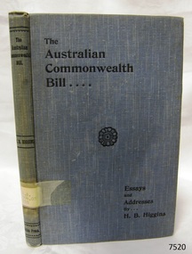
Book, Essays and Addresses on The Australian Commonwealth Bill
Essays and Addresses on The Australian Commonwealth Bill by Henry Bournes Higgins, one of the Victorian Members of the Australiasian Federal Convention, 1897-1898 Publisher: The Atlas Press Date: 1900Label on spine cover with typed text R.A. 994.03 HIG Pastedown front endpaper has sticker from Warrnambool Mechanics Institute and Free Library warrnambool, shipwrecked-coast, flagstaff-hill, flagstaff-hill-maritime-museum, maritime-museum, shipwreck-coast, flagstaff-hill-maritime-village, shipwrecked-artefact, book, warrnambool mechanics’ institute, essays and addresses on the australian commonwealth bill, the australian commonwealth bill, henry bournes higgins, victorian members of the australiasian federal convention, australiasian federal convention, -
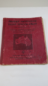 Kiewa Valley Historical Society
Book - Educational - School Atlas, Collins' Australian Clear School Atlas
Australian schools used Atlases to teach students geography and the nationalities of countries worldwide.Clare Roper was a resident of the Kiewa Valley. This atlas is of interest because it is circa 1950s and shows the world at this time.Thick red cardboard cover with black print and map of Australia on cover. It includes coloured maps of countries, black & white photos and an index at the back. On the inside of the cover both front and back it has black and white maps. There are 30 pages and it is bound. Circa 1950sCover page: handwritten "Margaret Tulloh / C. Roper / Margaret Tulloh / M.L.C. Some pages have been marked with pencilaustralian school atlas, clare roper -
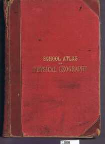 Greensborough Historical Society
Book, W. & A.K. Johnston, School atlas of physical geography: the elementary facts of geology; hydrography; meteorology and natural history by Alex Keith Johnston, 1871_
This atlas of physical geography has 20 plates illustrating maps and various rock formations.This volume illustrates a 19th century view of physical geography.51 pages, 20 plates, maps. Red hard cover with title in gold lettering.Inscribed on fly leaf with original owner's name (1890)atlas, physical geography -
 Flagstaff Hill Maritime Museum and Village
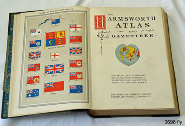
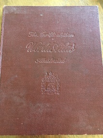
Book, Harmsworth Atlas and Gazetteer, 1908
This Harmsworth Atlas and Gazetteer was inherited by one of the donors, a gift from her father who was Tasmanian.Large hard covered book with maps, charts and tables. The cover is green linen with green leather, gilt trimmed corners and decorative spine, It includes 500 maps and diagrams in colour, with commercial statistics and gazetteer index of 105,000 names. Jan 1908. Also inserted between the pages of the book were 2 folded sheets of waxed paper, each with carefully placed flowers pressed between them; native orchids and wattle. Published at Carmelite House, Carmelite Road, London flagstaff hill, warrnambool, shipwrecked coast, flagstaff hill maritime museum, maritime museum, shipwreck coast, flagstaff hill maritime village, great ocean road, harmsworth atlas and gazetteer, atlas 1908, maps 1908, gazetteer 1908, book 1908, pressed australian native flowers, pressed wattle, pressed orchid -
 Ballarat Heritage Services
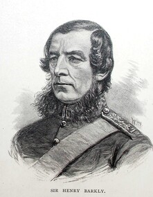
Image, Sir Henry Barkly, Governor of Victoria, c1886
First Published in Picturesque Atlas of Australia. Artist William Macleod, (1850-1929) had an extensive involvement in the 'Picturesque Atlas of Australasia' publication executing many of the portraits and was chairman of its publishing company. Macleod went onto join the Bulletin full time in 1886. (http://adb.anu.edu.au/biography/macleod-william-7419, accessed 28 March 2019)Line drawing of Henry Barkly.henry barkly, portrait, governor barkly, william macleod -
 National Wool Museum
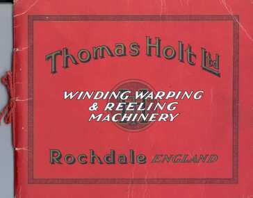
Booklet, Thomas Holt Ltd - Winding, Warping and Reeling Machinery
Catalogue of winding, warping and reeling machinery produced by the textile machinery manufacturers Thomas Holt Ltd at the Atlas Ironworks, Rochdale.Booklet, 36pp. Red card cover bound with red cord tie. Cover is printed with text in black, white and gold. Contains black and white illustrations of machinery.Thomas Holt Ltd / WINDING WARPING / & REELING / MACHINERY / Rochdale ENGLAND / TH Ltdthomas holt limited, warping machinery, winding machinery, reeling machinery -
 Yarrawonga and Mulwala Pioneer Museum
Book, The Specialty Press, The New Elizabethan World Atlas Illustrated, 1952
Provides names of countries and their borders as they were during the 1950'sMaroon hard cover illustrated atlas. Front embossed with title and royal seal. 152 pages. Contains detailed maps of world countries in colour. Early world history and it's development and comprehensive gazetteer.Owners name written in front pagesmaps -
 Greensborough Historical Society
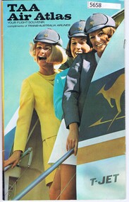
Booklet, TAA Air Atlas, 1972_
Souvenir publication, detailing airline routes, services and aircraft. TAA air atlas: your flight souvenir, compliments of Trans-Australia Airlines.16 p., printed in colour, maps, photographs and text.airlines, trans-australia airlines -
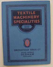 National Wool Museum
Catalogue, Textile Machinery Specialities
"Textile Machinery Specialities" - Dronsfield Bros Ltd, Atlas Works, Oldham, England, 13th ed. 1924. Catalogue for grinding machines and card making machines.textile machinery, dronsfield bros ltd -
Port Melbourne Historical & Preservation Society
Archive - Alan Mathews and family
The Mathews family have been in continuous ownership of 395 Howe Parade (was 8 Howe Parade until 1964 when addresses re-assigned), Port Melbourne from 1938 to the present (Sept 2019)Six folders of assorted documents relating to the life of Alan Mathews and his family. Collected items, paper notes, drawings from Alan's childhood. Nestle's Picture Album, Pictorial Atlas. Picture no 88 Rhineland castle Germanydomestic life, alan mathews