Showing 37 items matching "auriferous"
-
 Stawell Historical Society Inc
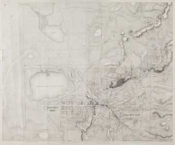
Map, Plan Shewing Auriferous Deposits and Reefs (Map of Water Races), c1878
... Plan Shewing Auriferous Deposits and Reefs (Map of Water Races)...Plan Shewing Auriferous Deposits and Reefs (Map of Water Races)...Stawell Historical Society Inc 46 Longfield St Stawell grampians stawell water Plan Shewing Auriferous Deposits and Reefs (Map of Water Races) Plan Shewing Auriferous Deposits and Reefs (Map of Water Races) Map ...Plan Shewing Auriferous Deposits and Reefs (Map of Water Races)stawell, water -
Federation University Historical Collection
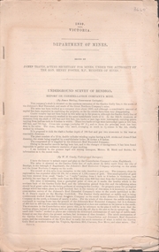
Booklet, Report of the Board Appointed to Advise the Government as to the Best Mode of Developing the Auriferous and Mineral Resources of the Colony, 1879-80, 1880
... Report of the Board Appointed to Advise the Government as to the Best Mode of Developing the Auriferous and Mineral Resources of the Colony, 1879-80...Report of the Board Appointed to Advise the Government as to the Best Mode of Developing the Auriferous and Mineral Resources of the Colony, 1879-80 Booklet Booklet John Ferres John Ferres ...White Foolscap printed Government document relating Victoria's mineral resources.mineral resources, mining, mining districts, ballarat mining district, auriferous resources, william collard smith, rivett henry bland, henry rosales, robert m. sergeant, a.w. howitt, deep leads, carisbrook, sebastopol, sebastopol plateau, r.m. harvey, james m. main, john wall, g. hale, t.h. thompson, james leckie, e.h. uren, james cotter, p. matthews, w.k. peden, john sharp, g.c. robinson, dead horse lead, william benson, j. keith, smythesdale, charles thorne, haddon, linton, little bendigo, scarsdale, blackwood, daylesford, owen jones, james mcmillan, h.h. sainsbury, thomas bury -
 Federation University Historical Collection
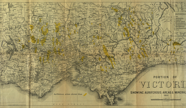
Photograph - coloured, Department of Lands and Survey, Portion of Victoria showing auriferous areas and mineral localities, 1935, 1935
... Portion of Victoria showing auriferous areas and mineral localities, 1935...Barker Library (top floor) Mount Helen goldfields Map included with book "Victoria: Gold and Minerals" issued by Mines Department Victoria, 1935 victoria auriferous areas mineral localities department of mines tin antimony copper silver lead tungsten manganese platinum iron Yellow mark indicating deposits Fold out coloured map Portion of Victoria showing auriferous areas and mineral localities, 1935 Photograph - coloured Department of Lands and Survey ...Map included with book "Victoria: Gold and Minerals" issued by Mines Department Victoria, 1935Fold out coloured mapYellow mark indicating depositsvictoria, auriferous areas, mineral localities, department of mines, tin, antimony, copper, silver lead, tungsten, manganese, platinum, iron -
 Federation University Historical Collection
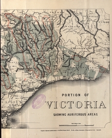
Map - Map and Information, Department of Mines: Map and Suggestions to Prospectors, 1891
... The map outlines the auriferous (gold bearing) areas in Victoria. The information for prospectors was prepared by the Department of Mines in 1894...Document: 4 page type written Map: Portion of Victoria divided into Counties of 1891. Auriferous areas with red....Auriferous areas with red. Department of Mines: Map and Suggestions to Prospectors Map Map and Information Robert S Bain Alexander Black Hon. ...The map outlines the auriferous (gold bearing) areas in Victoria. The information for prospectors was prepared by the Department of Mines in 1894Document: 4 page type written Map: Portion of Victoria divided into Counties of 1891. Auriferous areas with red.Reference section on mapgold, auriferous areas, department of mines, victoria, map of victoria, prospectors, commissioner of crown lands, hon a mclean, alexander black, surveyor general, a mclean -
 Myrtleford and District Historical Society
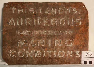
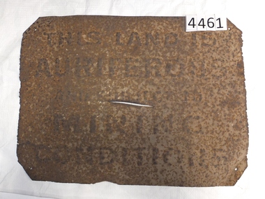
Gold Mining Sign
... Inscription: "THIS LAND IS AURIFEROUS AND SUBJECT TO MINING CONDITIONS"...Such signs continued to be in use during the period between World War 1 and 2,including the period of the Great Depression. Auriferous Mining Inscription: "THIS LAND IS AURIFEROUS AND SUBJECT TO MINING CONDITIONS" Tin rectangular mining sign embossed with a warning Gold Mining Sign ...This sign was required to be displayed in the vicinity of gold mining sites. Myrtleford district was known to have had 100 sites within a ten mile radius of the town; the sign was recovered by Charlie McFadyen, a local prospector and fossicker, of some 60 yearsThe sign relates to local gold mining activity, a key source of wealth and employment from 1854 to the late 19th century. Such signs continued to be in use during the period between World War 1 and 2,including the period of the Great Depression.Tin rectangular mining sign embossed with a warningInscription: "THIS LAND IS AURIFEROUS AND SUBJECT TO MINING CONDITIONS"auriferous mining -
Clunes Museum
Document - GEOLOGICAL REPORT, CIRCA 1897
... REPORT ON AURIFEROUS ZONE FROM ROKEWOOD TO CLUNES, AND THENCE TO MOUNT CAMERON...LIDGEY, FIELD GEOLOGIST, 1897 local history document report mining SEE OVER REPORT ON AURIFEROUS ZONE FROM ROKEWOOD TO CLUNES, AND THENCE TO MOUNT CAMERON Document GEOLOGICAL REPORT ...REPORT BY E. LIDGEY, FIELD GEOLOGIST, 1897REPORT ON AURIFEROUS ZONE FROM ROKEWOOD TO CLUNES, AND THENCE TO MOUNT CAMERONSEE OVERlocal history, document, report, mining -
Federation University Historical Collection
Book, George Brown, Prospectors' Guide (Victoria), 1936, 1936
... Brown soft covered book with pullout map showing auriferous areas of Victoria. ...Barker Library (top floor) Mount Helen goldfields prospecting gold geology quartz reefs indicators ballarat indicators miners' rights mining leases forest regulations equipment gold cradle puddling machine sluice box whim whip california pump cradle mining tools mining laws Brown soft covered book with pullout map showing auriferous areas of Victoria. Prospectors' Guide (Victoria), 1936 Book Book George Brown H.J. ...Brown soft covered book with pullout map showing auriferous areas of Victoria. prospecting, gold, geology, quartz reefs, indicators, ballarat indicators, miners' rights, mining leases, forest regulations, equipment, gold cradle, puddling machine, sluice box, whim, whip, california pump, cradle, mining, tools, mining laws -
 Federation University Historical Collection
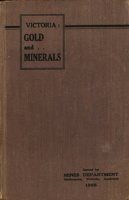
Book, Victoria: Gold and Minerals, 1935, 1935
... Fold out map showing auriferous areas and mineral localities in Victoria, 1935...Fold out map showing auriferous areas and mineral localities in Victoria, 1935 Victoria: Gold and Minerals, 1935 Book Book ...Hard cover book. Fold out map showing auriferous areas and mineral localities in Victoria, 1935victoria, gold, minerals, 1935, geological map, hydrolic sluicing, panning, pneumatic drill, puddling machine, bendigo, coal mine, wonthaggi, yallourn, jamieson valley, geological school, melbourne university, mount buffalo, electric power station, briquette factory, mines department, george brown, secretary of mines, e.j. hogan, minister of mines, mining -
 Federation University Historical Collection
Map, Ballaarat Gold Field, 1861, 1861
... Blue dots indicate gold leads, and red lines indicate auriferous quartz reef and outcrops of quartz veins....Blue dots indicate gold leads, and red lines indicate auriferous quartz reef and outcrops of quartz veins. ...A party of surveyors camped by Yuille's Swamp (later Lake Wendouree) and surveyed the countryside for a map to be produced by the Geological Survey of Victoria. In November 2004 the Central Highlands Regional Library presented a special edition of 200 copies of the 1861 map reproduced from a copy in their collection. Original 1861 map of Ballarat showing streets and leads. Blue dots indicate gold leads, and red lines indicate auriferous quartz reef and outcrops of quartz veins."Compiled & Drawn from the Survey of Mining Surveyors Davidson, Fitzpatrick and Cowan & the Plans in the Surveyor General's Office by J. Brahe, 21st October 1861. R. Brough Smyth, Secretary for Mines. The Honourable J.B. Humffray, M.L.A. Commr of Mines.”ballarat, map, ballarat east, lake wendouree, survey, mines, robert davidson, ballarat gold field 1861, yuille's swamp, wendouree swamp, little bendigo diggings, gold leads, old post office hill, specimen hill, bakery hill, black hill, dead horse creek, brown hill, pennyweight hill, clayton hill, soldiers hill, golden point, gum tree flat, white flat, poverty hill, chinese village, robert brough smyth, ballarat map 1861, ballaarat vineyard, dead horse gully, deadhorse creek, invermay, black hill flat, gaelic church, police reserve, magpie range, dalton's flat, caadian lead, rifle butts, powder magazine, bathing house, government camp, gold office, chinese, llanberrris, victoria theatre, charlie napier hotel, united states hotel, grape's hoel, clayton's hill, cattleyard hill, free trade hotel, esmond lead, bakery hill, black hill lead, juvenile reformatory, ballarat orphanage, lady barkly lead, triffet's slaughter yard, little bendigo, melbourne road, t. cowan, thomas cowan -
 Whitehorse Historical Society Inc.
Letter - Correspondence, Warrandyte, 1/08/1857
... Letter from Survey Office dated 1 August 1857 referring to auriferous indications on each side of Deep Creek revealed in the course of a survey of roads to the Warrandyte Gold Fields....Whitehorse Historical Society Inc. 2-10 Deep Creek Road Mitcham melbourne Warrandyte Goldmining Deep Creek Nunawading Letter from Survey Office dated 1 August 1857 referring to auriferous indications on each side of Deep Creek revealed in the course of a survey of roads to the Warrandyte Gold Fields. ...Letter from Survey Office dated 1 August 1857 referring to auriferous indications on each side of Deep Creek revealed in the course of a survey of roads to the Warrandyte Gold Fields.warrandyte, goldmining, deep creek, nunawading -
 Stawell Historical Society Inc
Memorabilia - Realia, 1850-1920's
... Rusted Tin Sign – "THIS LAND IS AURIFEROUS AND SUBJECT TO MINING CONDITIONS" This sign was required to be displayed in the vicinity of gold mining sites. ...Stawell Historical Society Inc 46 Longfield St Stawell grampians Stawell Rusted Tin Sign – "THIS LAND IS AURIFEROUS AND SUBJECT TO MINING CONDITIONS" This sign was required to be displayed in the vicinity of gold mining sites. ...Rusted Tin Sign – "THIS LAND IS AURIFEROUS AND SUBJECT TO MINING CONDITIONS" This sign was required to be displayed in the vicinity of gold mining sites. From 1850'c to between the two world wars. Found near Rhymney Hill Great Westernc1966stawell -
 Federation University Historical Collection
Book, Selection of Geological Publications, 09/1866
... ...auriferous...The book includes: 1. Auriferous, Leads, & Silver Ores at Upper Hungary - G.H.F. ...The book includes: 1. Auriferous, Leads, & Silver Ores at Upper Hungary - G.H.F. ...This book was owned and used by Professor Ferdinand M. Krause of the Ballarat School of Mines.Ferdinand Krause was a renowned teacher at the Ballarat School of Mines. He also produced many important Geological Maps. This book has seven reports that Krause had bound together for his own use. Half black leather bound book with hand marbled paper cover. Marbling on cover is grey, maroon and darker grey with gold bands on black leather spine. The book contains 7 papers on various subjects associated with ores. The book includes: 1. Auriferous, Leads, & Silver Ores at Upper Hungary - G.H.F. Ulrich, 1868 2. Nuggetty Reef, Maldon, Victoria - G.H.F. Ulrich, 1866 3. Internal Communication - Lieut. Amsinck, 1856 4. Roads for Victoria - William Macredie, 1856 5. Mining & Mineral Statistics of Victoria - Robert Brough Smyth, 1866 6. Physical Geography & Geology of Victoria - R.C. Selwyn, 1866 7. Mineralogy of Victoria - G.H.F. Ulrich, 1866 Leather component is black with gold bands on spine with "Silver Ores etc" written on spine. 'G" on square cream paper at top of spine; "2" on square cream paper on middle of spine; and "3" on square cream paper on bottom of spine. Inside front cover on red paper rectangle near spine "bound by W. PAUL 17 Lydiard St BALLARAT" "Ferdinand M Krause C E" handwritten in black ink on title page of first paper (right hand side)treatment, auriferous, lead, silver ores, nuggetty reef, maldon, victoria, internal communication, roads for victoria, mining, mineral statistics, geography, geology, mineralogy, ulrich, amsinck, selwyn, ferdinand krause, macredie -
 Bendigo Historical Society Inc.
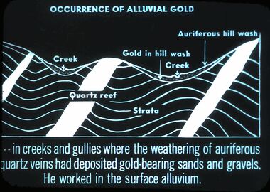
Slide - DIGGERS AND MINERS. DIGGERS AND MINERS, c1850s
... In creeks and gullies where the weathering of auriferous quartz veins had deposited gold-bearing sands and gravels. ...In creeks and gullies where the weathering of auriferous quartz veins had deposited gold-bearing sands and gravels. ...Diggers and miners. Diggers and Miners. . . In creeks and gullies where the weathering of auriferous quartz veins had deposited gold-bearing sands and gravels. He worked in the surface alluvium. Picture shows diagram of this. Markings: 7 994.5 WAL. Used as a teaching aid.hanimounteducation, tertiary, goldfields -
Federation University Historical Collection
Booklet, Ballarat School of Mines, Prospectus, 1905-1906, 1905
... It also includes an advertisement for the practical treatment of Auriferous Ores in the Ballarat School of Mines Mining Laboratory. ...It also includes an advertisement for the practical treatment of Auriferous Ores in the Ballarat School of Mines Mining Laboratory. ...The Ballarat Technical Art School was part of the Ballarat School of MinesTwo Ballarat School of Mines Prospectuses of 16 pages. Both are the same but have different colour covers Contents includes teaching staff, school hours and subjects. It also includes an advertisement for the practical treatment of Auriferous Ores in the Ballarat School of Mines Mining Laboratory. ballarat school of mines, ballarat technical art school, design, modelling, figure drawing, fashion plate drawing, black and white illustration, wood carving, lettering, art metal work, retouching, architecture, architectural diploma, draughtsmen's courses, art teachers' courses, outdoor sketching classes, photography, building construction, architectural drawing, ticketwriting, signwriting and decorating, dressmaking, needlework, art teachers' certificate., ballarat school of mines model mine -
 Bendigo Historical Society Inc.
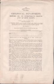
Document - MINING REPORTS - REPORT OF, ON AURIFEROUS DRIFTS AND QUARTZ REEFS
... Printed document: Geological Department: Report of, on auriferous Drifts and Quartz Reefs, dated 8th May,1866. ...Document MINING REPORTS - REPORT OF, ON AURIFEROUS DRIFTS AND QUARTZ REEFS ...Printed document: Geological Department: Report of, on auriferous Drifts and Quartz Reefs, dated 8th May,1866. Paper describes the gravels and rocks of a Geological Survey. Survey is compared with the lower drifts of Bendigo, Epsom, Ballaarat, Castlemaine and other gold-fields. Four colour sketch-sections included. Document is part of the Albert Richardson Collection. gold, mining reports, mining reports, report of, on auriferous drifts and quartz reefs, mr bindon, alfred r c selwyn, john ferres -
 Bendigo Historical Society Inc.
Book - DICKER'S MINING RECORD & GUIDE TO THE GOLD MINES OF VICTORIA, 1863
... Dicker's Mining Record and Guide to the Gold Mines of Victoria; showing the bearings, depths, thicknesses and underlies pf the Auriferous Lodes. The progress and cost of works in operation; containing also a variety of valuable interesting and statistical information. ...Thomas Dicker Dicker's Mining Record and Guide to the Gold Mines of Victoria; showing the bearings, depths, thicknesses and underlies pf the Auriferous Lodes. The progress and cost of works in operation; containing also a variety of valuable interesting and statistical information. ...Dicker's Mining Record and Guide to the Gold Mines of Victoria; showing the bearings, depths, thicknesses and underlies pf the Auriferous Lodes. The progress and cost of works in operation; containing also a variety of valuable interesting and statistical information. Vol. 11 - 1862 - 3. Published by the proprietor, Thomas Dicker with 276 pages. Green hardcover bound in leather with gold lettering and paper.Thomas Dickergold mining, mining equipment, mining records, mining, gold mines, mining statistics, mining companies. -
 Bendigo Historical Society Inc.
Document - UNDERGROUND SURVEY OF BENDIGO MINES
... Mine shaft and New Chum Railway and Shenandoah auriferous reef below 2700 feet....Mine shaft and New Chum Railway and Shenandoah auriferous reef below 2700 feet. Document UNDERGROUND SURVEY OF BENDIGO MINES ...Two page document, 'Underground survey of Bendigo, report on Constellation Company's Mine on northern extension of the Garden Gully line of reef. Report on the New Chum Railway Reserve Company and the Shenandoah Company, the New Chum Railway Co being immediately south and the Shenandoah Co immediately north of the railway line. Two maps Constellation Co. Mine shaft and New Chum Railway and Shenandoah auriferous reef below 2700 feet.Jems Stirling, geologist and W.H Cundy Underground Surveyor, Department of Minesbendigo, mining, garden gully line of reef mines -
 Bendigo Historical Society Inc.
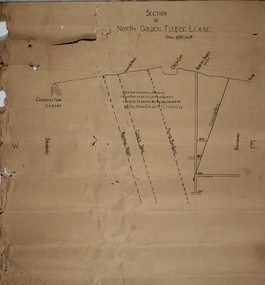
Plan - North Golden Fleece Lease, unknown
... Written on plan in black print: 'This belt of country contains large bodies of auriferous quartz and at present is being operated on by the New Golden Fleece Company'. ...Written on plan in black print: 'This belt of country contains large bodies of auriferous quartz and at present is being operated on by the New Golden Fleece Company'. ...Map drawn on heavy paper, titled 'Section of North Golden Fleece lease'. Scale 80 ft to 1 inch. Written on plan in black print: 'This belt of country contains large bodies of auriferous quartz and at present is being operated on by the New Golden Fleece Company'. Reef lines marked on plan: Ramrod Reef, Comet Reef, Stafford Reef and Frying Pan Reef. The water race, Albert shaft and open cut are marked at the surface level. This plan is part of the Margaret Roberts Collection. north golden fleece gold mine, gold mining, bendigo, lease holding, albert gold mine, ramrod reef, comet reef, stafford reef and frying pan reef -
 Bendigo Historical Society Inc.
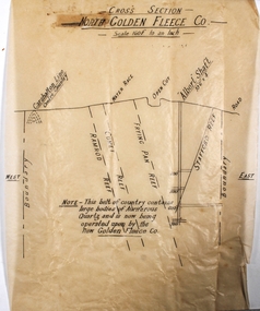
Plan - North Golden Fleece Mine
... On bottom of plan: ' This belt of country contains large bodies of auriferous quartz and is now being operated upon by the New Golden Fleece Co.' ...On bottom of plan: ' This belt of country contains large bodies of auriferous quartz and is now being operated upon by the New Golden Fleece Co.' ...North Golden Fleece Gold Mine was located approx. 1200m west of Spring Gully Reservoir, near Diamond Hill Road. Plan drawn on tan tissue paper, black text. Written across top of plan: 'Cross Section, North Golden Fleece Co. 160' to an inch'. Annotations on plan: Carshalton line, water race, open cut, Albert Shaft 10'6" x 4, road. East and West marked on plan. On bottom of plan: ' This belt of country contains large bodies of auriferous quartz and is now being operated upon by the New Golden Fleece Co.' Plan forms part of the Margaret Roberts Collection of mining records. margaret roberts, gold, gold mine, bendigo, north golden fleece gold mine, spring gully reservoir -
 Federation University Historical Collection
Book - Register, Ballarat School of Mines Donation Book, 1878 - 1895
... Nature of Donation: Specimens nos (797-806) 797-801 from the New Reform Mine Luchnow, NSW (797) Serpentine with vein of quartz and calcite (798) Surpentine passing into silicous ferruginoous gossan; with drives of rock crystal (&99) Diorite with vein of calcite (800) Auriferous vein stuff (801) Auriferous arrenopyrite with calcite (802) noble opal filling cavities in decomposed traclyte (803-805) from Mr McDonald, NSW (806) arutute (carbonate of lead) in long schombie purni (?) ...Nature of Donation: Specimens nos (797-806) 797-801 from the New Reform Mine Luchnow, NSW (797) Serpentine with vein of quartz and calcite (798) Surpentine passing into silicous ferruginoous gossan; with drives of rock crystal (&99) Diorite with vein of calcite (800) Auriferous vein stuff (801) Auriferous arrenopyrite with calcite (802) noble opal filling cavities in decomposed traclyte (803-805) from Mr McDonald, NSW (806) arutute (carbonate of lead) in long schombie purni (?) ...The Ballarat School of Mines was the first School of Mines in the southern hemisphere. Its Museum was established in 1872. Donation 600, 4 July 1882, H. Sutton, Ballarat. Nature of Donation: 13th Annual report of the Aeronautical Society of Great Britain 2 papers 'from the proceedings of the Royal Society', Nos 217 & 218 - 1882 communicated by the President :on a new electrical Storage battery" by Henry Sutton, Ballarat, Victoria Donation 976, 8 May 1884, H. Sutton, Ballarat. Nature of Donation: * 1 volume "Pluttner on the Blowpipe: (Pluttner's manual of qualitative & quantitative analysis of the blowpipe. Donation 1682, 28 Feb 1887, James Lamb, Ballarat. Nature of Donation: Copy of "The Ballarat Times" newspaper of 3 December 1854, framed, and protected on both sides with glass. Donation 1712, 28 April 1887, Marg. Guerin, Ballaarat. Nature of Donation: Specimens nos (797-806) 797-801 from the New Reform Mine Luchnow, NSW (797) Serpentine with vein of quartz and calcite (798) Surpentine passing into silicous ferruginoous gossan; with drives of rock crystal (&99) Diorite with vein of calcite (800) Auriferous vein stuff (801) Auriferous arrenopyrite with calcite (802) noble opal filling cavities in decomposed traclyte (803-805) from Mr McDonald, NSW (806) arutute (carbonate of lead) in long schombie purni (?) Donation 1730, 23 May 1887, Miss Guerin, Ballaarat. Nature of Donation: Copy of the Victorian Review No 74 December 1 1885, Copy Wide Awake Vol 1 No 6 May 21st 1887Large rough calf covered book recording museum, laboratory and library donations to the Ballarat School of Mines. 4835 donations are recorded.Marbled end papers. Labels on spine and front cover.ballarat school of mines, ballarat school of mines museum, benjamin hepburn, ce clarke, j noble wilson, m hamburger, d christy, edwin jewell, ellery, john gray, go preshaw, cf crouch, henry brind, james darby, rm serjeant, george day, jf watson, stoddart, j hicks, hicks, james hector, sleep, jj sleep, james pearce, henry obree, newman, william tarrant, beilby, william bradford, george lansell, watson, edward gazzard, e morey, john lynch, j hector, rivett bland, bland, costin, whittle, crowther, mitchell, ferdinand krause, krause, joseph mitchell, john walker, bailey, duncan, mica smith, alfred mica smith, james buchanan, buchanan, whitehouse, dr bunce, bunce, james bklack, james bickett, js north, joseph flude, alfred lester, wagemann, fw niven, edwards, william evett, john addis, al elphinstone, henry sutton, ol olden, bh cross, robert hamilton, hancock, ferdinand von mueller, von meuller, berchevaise, j whitehouse, serjeant, henty, james shugg, john ross, james oddie, ralph tate, henry watts, wh wooster, wooster, luplau, rosenblum, heddington, albert furmedge, buley, robert wilson, e. rowlands, ne hall, henry pearce, lee young, nicholls, dusontory, daniel brohpy, brophy, klug, james donaldson, john cherry, ce jones, john feilds, thomas williams, enscoe, e price, shoppee, jacob drew, george wyatt, dimmock, james orr, john hardy, george wyatte, thomas rogers, james lamb, doepel, margaret guerin, bella guerin, guerin, george binns, william laplau, captain baker, baker, crisp, barnard, haffie, bateman, chalmers, richard parker, adam adamson, jn wilson, john noble wilson, papenhagen, towl, government astronomer, royal society, minister of mines, thoams blackett, burbury, denny, thys, p gay, james law, woolnough -
 Bendigo Historical Society Inc.
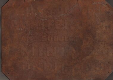
Sign - GOLDFIELDS SIGN
... The embossing reads: 'This Land is Auriferous and Subject to Mining Conditions.' ...The embossing reads: 'This Land is Auriferous and Subject to Mining Conditions.' ...Metal sign with embossed lettering, the corners have been folded over with mounting holes put through the thicker sections. The embossing reads: 'This Land is Auriferous and Subject to Mining Conditions.' The sign is very rusted and there is no trace of the original paintwork. A handwritten note with the sign reads: 'This sign was found covered by grass and eucalyptus leaves etc., at the side of the road leading past the Eucy. Factory in the vicinity of the Whipstick forest. Found in 1977 by Jean and Ross Miller, Wireless Street, Kangaroo Flat. At the time of scanning the lead article. The second item, a ladle, is being held in another location.gold mining, miners' safety cage, signage, gold mining, land use, signs -
 Bendigo Historical Society Inc.
Document - EXTRACT FROM THE BENDIGO INDEPENDENT APRIL 16 1887: MYERS FAMILY/MYERS CREEK, 16th April, 1887
... Titled The local dawn of civilization - A Pre-auriferous pioneer. Settlement by William and Thomas Myers. ...Titled The local dawn of civilization - A Pre-auriferous pioneer. Settlement by William and Thomas Myers. ...Extract from the Bendigo Independent April 16 1887 re Myers Family/Myers Creek. Titled The local dawn of civilization - A Pre-auriferous pioneer. Settlement by William and Thomas Myers. Story of settlement of area told by first wife of William Myers (Mrs Hayward). Recollection of Mrs Hayward's re the naming of Bendigo ( ('bendy-go'). Reference to Mr Campbell, Bullock Creek Hotel and Station; Mr John Catto (Loddon homestead); Mouat Bros (Yarraberb Station) M'Intyre (squatter of Kangaroo Flat and Big Hill) ; Buzza's Paddock (Myers' Flat). Mention of Superintendent Gilbert and Dr Backhaus.Bendigo Independentperson, individual, myers family, myers flat police station, buzz's paddock, bullock creek hotel and station, port phillip, myers creek. -
Federation University Historical Collection
Letter, Inwards Correspondence to the Ballarat School of Mines, 1898, 1898
... * Letter from Thomas Harwood from Port Darwin concerning bags of auriferous sand for treatment. * Letterhead from Ivor Davies, Cambrian Battery, Mosquito Flat * Request for results and certificates from D.W. ... * Letter from Thomas Harwood from Port Darwin concerning bags of auriferous sand for treatment. * Letterhead from Ivor Davies, Cambrian Battery, Mosquito Flat * Request for results and certificates from D.W. ...A number of handwritten letters bound together with a brass split pin on the top right corner. * Letter from Thomas Harwood from Port Darwin concerning bags of auriferous sand for treatment. * Letterhead from Ivor Davies, Cambrian Battery, Mosquito Flat * Request for results and certificates from D.W. Kennedy * J.H. Salter requesting a Ballarat School of Mines prospectus * Ballarat School of Mines Indentures student Thonmas Andrews * Letter introducing prospective student Walter Pomeroy * Ballarat School of Mines visit to New Normanby Mine * Letter from Sara McLean of Daylesfors asking about Botany, Geology and Drawing classes and railway forms. thomas harwood, darwin, mining, letterhead, ivor davis, frogmore sorell tasmania, d.w. kennedy, james horsfall, walter andrews, thomas p. lewis, j.h. salter, lettercard, queenstown tasmania, arch douglas, thomas andrews, gundagai, joseph bryant, c.m. bryant, percy glenton, clunes, land surveying, chalk and cahir, steam gauge testing, brisbane newspaper company, h. herman, t. price, geelong college letterhead, walter pomeroy, industrial schools act, n.r salmon, james and mccrindle, homes mccrindle, broken hill, j.e. blake, norval, john pearce, new nprmanby mine, maryborough school of mines, duncan mcdougall, old scotch collegians club, w.a. gosman, broken hill pty co. ltd, w. robertson, howard smith and sons, sara mclean, daylesford, william h. nicholas, surprise gold mining company, a. vaudeau, j.w. banfield, letterhead*, william howard smith and sons, port pirrie, blakeville, royal mint, assay -
 Federation University Historical Collection
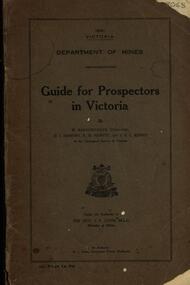
Book, Guide for Prospectors in Victoria, 1931, 1931
... Includes fold out map of a portion of Victoria showing auriferous areas and mineral localities. Also show Counties of Victoria and localities of minerals such as tin, antimony, copper, silver lead, Malybdenite, tungsten ores, manganese, platinum, osmiridium and iron. ...Includes fold out map of a portion of Victoria showing auriferous areas and mineral localities. Also show Counties of Victoria and localities of minerals such as tin, antimony, copper, silver lead, Malybdenite, tungsten ores, manganese, platinum, osmiridium and iron. ...The handbook was intended for those with little experience who wanted to prospect of fossick.Grey soft covered book of 90 pages. Includes fold out map of a portion of Victoria showing auriferous areas and mineral localities. Also show Counties of Victoria and localities of minerals such as tin, antimony, copper, silver lead, Malybdenite, tungsten ores, manganese, platinum, osmiridium and iron. Chapter heading s include: working alluvial deposits, equipment, geology of Victoria, gold deposits, quartz reefs, indicators, economic minerals, assistance to prospectors, Miners' Right, mining bye-law, mining leases, forest regulations and glossary. Descriptions are given of a god dish, puddling tub, cradle, puddling machine, ground sluicing, boring, windlass, whim, hand dollying, sweeping, California pump, and wing dam.mining, baragwanath, gold, prospector, geology, quartz reefs, alluvial deposits, indicators, victorian goldfields, miners rights, mining leases, forest regulations, sluicing, sluice box, puddling machine, miner's cradle, whim, whip, california pump, gold nuggets, saddle reef, ballarat indicators, state batteries -
 Ballarat Heritage Services
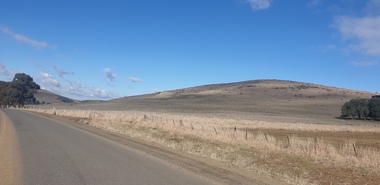
Photograph - Colour Photograph, Clare Gervasoni, Mount Greenock, 2025, 28/06/2025
... The lava flow and the scoria cone overlie the Greenock lead (a buried valley with auriferous gravels). A line of mine tailing and abandoned mining relics associated with the former Union Mine occur on the margins of the lava flow. ...The lava flow and the scoria cone overlie the Greenock lead (a buried valley with auriferous gravels). A line of mine tailing and abandoned mining relics associated with the former Union Mine occur on the margins of the lava flow. ...Mt Greenock is an extinct volcano with lava flows associated with a deep lead. It is a tall scoria cone with a broad shallow crater open to the northwest. In the crater are blocks and bombs of scoriaceous basalt. Long lava flows extend both north and south from the cone. It is considered a significant geological site, and part of the Major Mitchell Trail, with a 1936 ‘Centenary of Major Mitchell ‘monument on the summit. The flow to the north has been eroded by McCallum Creek which is a lateral stream. On the eastern base of the cone, the stream valley exposes a lava flow and underlying sedimentary rocks. The lava flow and the scoria cone overlie the Greenock lead (a buried valley with auriferous gravels). A line of mine tailing and abandoned mining relics associated with the former Union Mine occur on the margins of the lava flow. Mount Greenock is a 120 hectare ‘Geological Reserve’, is one of the few large scoria cones on public land and contains abundant outcrop and morphological evidence of its volcanic origin. Colour Photographs of Mt Greenock, near Talbot, Victoria. The photographs were taken in winter not long after the first post drought rains. Mt Greenock was climbed by Major Thomas Mitchell on 26 September 1936, and he gave it the current name. At that time the mount was part of Alexander McCallum's Dunach Forest Pastoral Run.mt greenock, mount greenock, mining, mullock heap, mt greenock geological reserve, union mine, volcanic grasslands, dunach -
 Ballarat Heritage Services
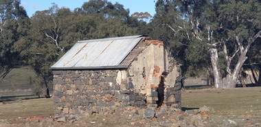
Photograph - Colour Photograph, Clare Gervasoni, Built Remains near Mount Greenock, 2025, 28/06/2025
... The lava flow and the scoria cone overlie the Greenock lead (a buried valley with auriferous gravels). A line of mine tailing and abandoned mining relics associated with the former Union Mine occur on the margins of the lava flow. ...The lava flow and the scoria cone overlie the Greenock lead (a buried valley with auriferous gravels). A line of mine tailing and abandoned mining relics associated with the former Union Mine occur on the margins of the lava flow. ...Mt Greenock is an extinct volcano with lava flows associated with a deep lead. It is a tall scoria cone with a broad shallow crater open to the northwest. In the crater are blocks and bombs of scoriaceous basalt. Long lava flows extend both north and south from the cone. It is considered a significant geological site, and part of the Major Mitchell Trail, with a 1936 ‘Centenary of Major Mitchell ‘monument on the summit. The flow to the north has been eroded by McCallum Creek which is a lateral stream. On the eastern base of the cone, the stream valley exposes a lava flow and underlying sedimentary rocks. The lava flow and the scoria cone overlie the Greenock lead (a buried valley with auriferous gravels). A line of mine tailing and abandoned mining relics associated with the former Union Mine occur on the margins of the lava flow. Mount Greenock is a 120 hectare ‘Geological Reserve’, is one of the few large scoria cones on public land and contains abundant outcrop and morphological evidence of its volcanic origin. Colour Photographs of bluestone and brick buildings at Mt Greenock, near Talbot, Victoria. The photographs were taken in winter not long after the first post drought rains. mt greenock, mount greenock, mining, mullock heap, mt greenock geological reserve, union mine, volcanic grasslands, dunach -
 Bendigo Historical Society Inc.
Slide - DIGGERS & MINING. DIGGERS AND MINERS, c1953
... A few weeks ill luck at Bendigo disgust a man with his auriferous well sinking and he goes into some sort of service. ...A few weeks ill luck at Bendigo disgust a man with his auriferous well sinking and he goes into some sort of service. ...Diggers & Mining. Diggers and miners. Many diggers not only moved from field to field, but alternated between gold digging and other occupations. Slide; THE STATE OF VICTORIA - - - Gold digging and other sorts of labour have arrived at a sort of equilibrium; and streams of people are now flowing from the one occupation to the others, and visa versa. A few weeks ill luck at Bendigo disgust a man with his auriferous well sinking and he goes into some sort of service. A dispute with his master chiming in with some current takes of mining success sends him back to the diggings again; and so the stream flows backwards and forwards keeping - - - the wages of all kinds of labour at an equilibrium - - - (M.M.H., August 19, 1853) Markings: 46 994:LIF I. Used as a teaching aid.hanimounteducation, tertiary, goldfields -
 Bendigo Historical Society Inc.
Document - GARDEN GULLY LINE OF REEF, LEASE BLOCKS 5360 AND 5361
... The area described is about 'one mile and a quarter southeast from the centre of the city of Bendigo, immediately south of the Great Southern Gold Mining Company's workings and is intersected by two auriferous gullies ... Salomon's Gully and Derwenter's Gully'. ...The area described is about 'one mile and a quarter southeast from the centre of the city of Bendigo, immediately south of the Great Southern Gold Mining Company's workings and is intersected by two auriferous gullies ... Salomon's Gully and Derwenter's Gully'. ...Two page document titled ' Report on lease blocks Nos. 5360 and 5361 Garden Gully line of reef, Bendigo. Produced by the Department of Mines 1899. The area described is about 'one mile and a quarter southeast from the centre of the city of Bendigo, immediately south of the Great Southern Gold Mining Company's workings and is intersected by two auriferous gullies ... Salomon's Gully and Derwenter's Gully'. The alluvial deposits, the Garden Gully line, the Great Souther Co.and old workings are discussed in the paper. A map of the Garden Gully line of reef is attached to the report, showing claimholders and mine names along that section of the reef. Mines named on the map: Great Southern Garden Gully United Ulster Londonderry Burrows Horwoods Sea Amalgamated Garden Gully United Victory and Pandora Unity Carlisle and Garden Gully and Passbye United Cornish United Koch's PioneerJames Stirling, Government Geologistbendigo, mining, garden gully line of reef mines -
 Bendigo Historical Society Inc.
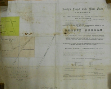
Document - MARKS COLLECTION: BOUNDY'S FREEHOLD GOLD MINES MALMSBURY
... Plan/advertisement 1888 for the sale of the Boundy's Freehold Gold Mines Malmsbury, 260 acres of auriferous and arable freehold land. Document contains map of mines, names include O'Connors Freehold Company, Egyptian Company, Queen's Birthday Company, No.1 South Queen Company, Madam O'Connor's company, Extended South Queen's Birthday Company. ...History House 11 Mackenzie Street Bendigo goldfields MINE Gold boundy's freehold gold mine Plan/advertisement 1888 for the sale of the Boundy's Freehold Gold Mines Malmsbury, 260 acres of auriferous and arable freehold land. Document contains map of mines, names include O'Connors Freehold Company, Egyptian Company, Queen's Birthday Company, No.1 South Queen Company, Madam O'Connor's company, Extended South Queen's Birthday Company. ...Plan/advertisement 1888 for the sale of the Boundy's Freehold Gold Mines Malmsbury, 260 acres of auriferous and arable freehold land. Document contains map of mines, names include O'Connors Freehold Company, Egyptian Company, Queen's Birthday Company, No.1 South Queen Company, Madam O'Connor's company, Extended South Queen's Birthday Company. Scale 10 chains to one inch. Taken from Mr. H. Archdale's Plan by Walter Sleeman, Mining Mgr., Oct 9th. 1888. On RH side of map Daylesford Road to Malmsbury marked. The land is only about two miles from the Malmsbury railway station. On back of document letter from Henry Nutman, Mining Manager, Queens Birthday Company; Report on Plan Walter Skleeman, M.M.; letter to S. Deeble, 35 Queen St., Melbourne with report on mine from George Jenkyn and Mining Manager's Report in Argus 24th.October 1888.mine, gold, boundy's freehold gold mine -
 Bendigo Historical Society Inc.
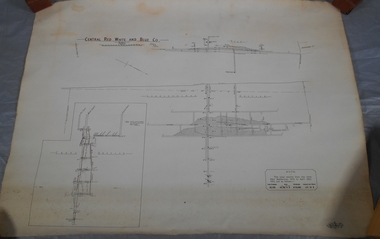
Plan - Central Red, White and Blue Mine
... That the Lansell Estate did not acquire this property on its becoming available is puzzling in the light of the fact that in Eadie's day the late Mr G W Lansell, on discovering auriferous spurs in the south shaft (now the Central Blue) had offered 2,000 pounds for, and a percentage of gold won from the lease. ...That the Lansell Estate did not acquire this property on its becoming available is puzzling in the light of the fact that in Eadie's day the late Mr G W Lansell, on discovering auriferous spurs in the south shaft (now the Central Blue) had offered 2,000 pounds for, and a percentage of gold won from the lease. https://search.informit.org/doi/10.3316/aesis.200105326 Bendigo gold Map Mine Central Red White & Blue Margaret Roberts Collection Sheepshead reef Draftsman's drawing of Central Red, White and Blue Mine Map. ...The Central Red White and Blue Gold Mine was Bendigo's leading gold mine from 1910 - 1913. During the mine's operation, the main shaft was sunk 670 metres, and retrieved over 2500KG of gold. The Central Red White and Blue Gold Mine was located on the corner of Chum St and Honeysuckle St in Golden Square. Extract from Whitelaw Report: Central Red White and Blue Mine, Bendigo. Author: H E Whitelaw Share Abstract Early in 1910, some considerable time after it had become generally known that a rich reef at a depth of 405 ft was being worked southward from the privately owned Lansell's Little 180 shaft and immediately following the plotting of the Geological Survey pitch diagram of the Sheepshead line of reefs, some wide awake local mining men seized the opportunity to secure the holding known as Eadie's which, overlapping Lansell's lease and containing a stretch of the Sheepshead reef channel between the Little 180 north and south shafts, had been declared void some five years previously. That the Lansell Estate did not acquire this property on its becoming available is puzzling in the light of the fact that in Eadie's day the late Mr G W Lansell, on discovering auriferous spurs in the south shaft (now the Central Blue) had offered 2,000 pounds for, and a percentage of gold won from the lease. https://search.informit.org/doi/10.3316/aesis.200105326 Draftsman's drawing of Central Red, White and Blue Mine Map. Printed by Troedel & Cooper Pty Ltd. Mr. H. Cundy, Surveyor Forms part of the Margaret Roberts Collection of mining records.bendigo, gold, map, mine, central red white & blue, margaret roberts collection, sheepshead reef