Showing 422 items matching "australian army operations"
-
 Wangaratta RSL Sub Branch
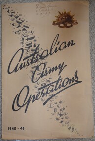
Map, Australian Army Operations 1940-45
... Australian Army Operations 1940-45...australian army operations...Large fold out map and chronology of Australian Army Operations between 1940-1945 that belonged to Private Joan Spencer VFX12932 (VF507134) born 12/11/1924 at Albury. ...Wangaratta RSL Sub Branch 2-4 Templeton Street Wangaratta high-country Large fold out map and chronology of Australian Army Operations between 1940-1945 that belonged to Private Joan Spencer VFX12932 (VF507134) born 12/11/1924 at Albury. ...Large fold out map and chronology of Australian Army Operations between 1940-1945 that belonged to Private Joan Spencer VFX12932 (VF507134) born 12/11/1924 at Albury. The family moved to Wangaratta and Joan was educated at Wangaratta High School before joining the Australian Army Medical Women's Service at 115 (Heidelberg) Military Hospital. She served with the 130 Australia General Hospital and was deployed overseas to Japan on 17/6/1947 and returned on 26/1/1949Large cream coloured cardboard folded in three, inside is a coloured map of the Middle East 1940-1942, New Guinea Theatre 1942-1944, Pacific Islands 1944-1945 and Malay and Islands 1942-1945. Front cover has Unit patches from top left to bottom right corner , at top right corner is the rising sun badge and bottom left corner 1940-45 Back cover is a listed Chronology.Hand written at top - VFX Pte Joan Spencer AAMWS 115 (H) M.H.australian army operations, private joan spencer, aamws, 130 agh -
 Lara RSL Sub Branch
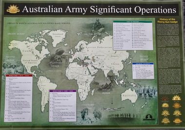
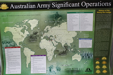
Map - Areas in Which Australian Soldiers Have Served - World War 1 and World War 2 and Other Theatres (2 Off), Australian Army Significant Operations Map. (2 Off)
... Australian Army Significant Operations Map. (2 Off)...Australian Army Significant Operations...Australian Army Significant Operations...Map of World showing Australian Armed Forces Theatre of Operations Australian Army Significant Operations Australian Army Significant Operations (Map)Rectangular in shape with a glossy front. (2 Off) Australian Army Significant Operations Map. (2 Off) Map Areas in Which Australian Soldiers Have Served - World War 1 and World War 2 and Other Theatres (2 Off) ...This map shows the areas in which Australian soldiers have served.Map of World showing Australian Armed Forces Theatre of Operations (Map)Rectangular in shape with a glossy front. (2 Off)Australian Army Significant Operationsaustralian army significant operations -
 Bendigo Military Museum
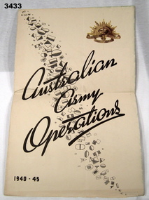
Poster - CHART WW2, ARMY OPERATIONS, LHQ Cartographic Coy, Aust Survey Corps with Directorate of Public Relations, A Chart of Australian Army Operations 1940 -1945, Post WW2
... A Chart of Australian Army Operations 1940 -1945...Front panel has title Australian Army Operations 1940 - 1945 printed in black ink, black & white divisional unit colour patches & gold coloured Rising Sun. ...A Chart of Australian Army Operations 1940 -1945 Poster CHART WW2, ARMY OPERATIONS LHQ Cartographic Coy, Aust Survey Corps with Directorate of Public Relations ...Strong paper chart folded 3 times. Front panel has title Australian Army Operations 1940 - 1945 printed in black ink, black & white divisional unit colour patches & gold coloured Rising Sun. Inside are 4 maps including Mediterranean Sea area, New Guinea, Pacific Islands - Borneo & Malaya. One panel has a chronology chart showing dates & events during 1939 - 1945.chart, operations, army 1939 - 45 -
 Ringwood RSL Sub-Branch
Work on paper - Australian army significant operations map, Memorabilia
... Australian army significant operations map...Ringwood RSL Sub-Branch 16 Station Street Ringwood melbourne World map of operations x 2 Memorabilia Work on paper Australian army significant operations map ...World map of operations x 2 -
 Monbulk RSL Sub Branch
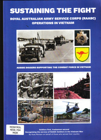
Book, Russell Morison, SUSTAINING THE FIGHT-ROYAL AUSTRALIAN ARMY SERVICE CORPS (RAASC) OPERATIONS IN VIETNAM : Aussie Diggers Supporting the Combat Force in the Vietnam War, 2021
... SUSTAINING THE FIGHT-ROYAL AUSTRALIAN ARMY SERVICE CORPS (RAASC) OPERATIONS IN VIETNAM : Aussie Diggers Supporting the Combat Force in the Vietnam War....Monbulk RSL Sub Branch 48 Main Road Monbulk yarra-valley-and-the-dandenong-ranges Royal Australian Army Service Corps Vietnam war - 1961-1975 - Australian participation The story of Australian Army support operations during the Vietnam conflict. ...The story of Australian Army support operations during the Vietnam conflict.Ill, maps, p.240.non-fictionThe story of Australian Army support operations during the Vietnam conflict.royal australian army service corps, vietnam war - 1961-1975 - australian participation -
 National Vietnam Veterans Museum (NVVM)
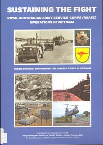
Book, Morison, Russell, Sustaining the Fight: Royal Australian Army Service Corps (RAASC) Operations in Vietnam, 2021
... Sustaining the Fight: Royal Australian Army Service Corps (RAASC) Operations in Vietnam....National Vietnam Veterans Museum (NVVM) 25 Veterans Drive Newhaven phillip-island-and-the-bass-coast Royal Australian Army Service Corps Vietnam Aussie Diggers supporting the Combat Force in the Vietnam War. Aussie Diggers supporting the Combat Force in Vietnam. Sustaining the Fight: Royal Australian Army Service Corps (RAASC) Operations in Vietnam. ...Aussie Diggers supporting the Combat Force in the Vietnam War.Aussie Diggers supporting the Combat Force in Vietnam.Aussie Diggers supporting the Combat Force in the Vietnam War.royal australian army service corps, vietnam -
 4th/19th Prince of Wales's Light Horse Regiment Unit History Room
Booklet, Department of Defence, Army: the first 200 years, 1 May 1977
... 18 page booklet summarising Australian Army operations from Waikato, 1863, to Vietnam...4th/19th Prince of Wales's Light Horse Regiment Unit History Room 4/19 PWLH Regiment, Building 78 Simpson Barracks Macleod melbourne Cat No 77 3553 5 18 page booklet summarising Australian Army operations from Waikato, 1863, to Vietnam Army: the first 200 years Booklet Department of Defence Alexander Brothers ...18 page booklet summarising Australian Army operations from Waikato, 1863, to VietnamCat No 77 3553 5 -
 Monbulk RSL Sub Branch
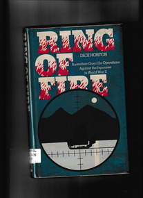
Book, Macmillan, Ring of Fire : Australian Guerrilla Operations Against the Japanese in World War II, 1983
... ...Australian army - Clandestine operations...Monbulk RSL Sub Branch 48 Main Road Monbulk yarra-valley-and-the-dandenong-ranges Australian army - Independent company - 2/2. 2/4. Australian army - Clandestine operations An account of the clandestine operations launced from Australiaon the Japanese occupied islands to its north during World War Two. ...An account of the clandestine operations launced from Australiaon the Japanese occupied islands to its north during World War Two.Index, ill, maps, p.164.non-fictionAn account of the clandestine operations launced from Australiaon the Japanese occupied islands to its north during World War Two.australian army - independent company - 2/2. 2/4., australian army - clandestine operations -
 Montmorency–Eltham RSL Sub Branch
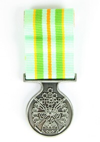
Medal - Military Kid Medallion, Foxhole Medals, After 2004
... As these young children endured an operational deployment of a parent who spent many months away from home in a foreign country representing the Australian Army. Following operations include Bougainville, East Timor, Indian Ocean, Solomon Islands, Meddle East Area, Afghanistan and Sinai....As these young children endured an operational deployment of a parent who spent many months away from home in a foreign country representing the Australian Army. Following operations include Bougainville, East Timor, Indian Ocean, Solomon Islands, Meddle East Area, Afghanistan and Sinai. ...This medal was presented to the children of Victorian Wing - Warrant Officer and Non Commissioned Officers Academy Soldier who have served on operational deployments. As these young children endured an operational deployment of a parent who spent many months away from home in a foreign country representing the Australian Army. Following operations include Bougainville, East Timor, Indian Ocean, Solomon Islands, Meddle East Area, Afghanistan and Sinai.Presented by the Government to children whose parents had served overseas Silver medal with pale green, yellow, orange and deeper green ribbon. It has a metal type container with a clear plastic front and also a black carry bag with Military Kid and print of medal on front. The design is based on the Australian Tri Service Logo. More detailed information can be found on Military Kids websiteOn reverse: "For perseverance on the home front during your parents deployment"; map of Australia (haut relief)military kid, military medal, kids medal -
 National Vietnam Veterans Museum (NVVM)
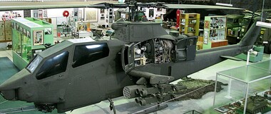
Vehicle - Helicopter, Bell AH-IG Cobra Bell AH-1, 1967 approx
... Army in Vietnam to support Australian & U.S. army ground operations. In addition to the M197 three barrelled 20mm Gatling gun, it carried eight anti-armour missiles and forty eight 2.75mm unguided air to ground rockets. ...Australia, this is the only one with full armament. Helicopters Bell weaponry Cobra US military equipment Gunship The aircraft is currently finished in a low visibility all-over mid green which includes the full US Army insignia and carries the Serial No. 69-15092 A heavily armed ground attack helicopter with single Lycoming T53-L-13 turbine engineused by the U.S. Army in Vietnam to support Australian & U.S. army ground operations ...After 2 years of negotiation between VVAA Representatives and the US Army, the Huey Cobra has landed in Melbourne. The exercise needed the support of our local Member, Mr. Greg Hunt, to ‘clear the way ‘ through the Customs and GST minefield. The helicopter, valued at $7.9 million is complete with full armaments and was brought to Museum standard while ensuring that no weaponry could ever be reactivated. The Museum paid for the helicopter to be ‘brought to museum standard’. This meant in part that the weaponry was rendered innocuous and various structural members were weakened to ensure that the craft would never fly again. Fortunately the alterations are not apparent to the display, and while there are two other Cobras in Australia, this is the only one with full armament. A heavily armed ground attack helicopter with single Lycoming T53-L-13 turbine engineused by the U.S. Army in Vietnam to support Australian & U.S. army ground operations. In addition to the M197 three barrelled 20mm Gatling gun, it carried eight anti-armour missiles and forty eight 2.75mm unguided air to ground rockets. This particular aircraft served in Vietnam from 1968 until 1971 and was damaged twice in combat. The aircraft is currently finished in a low visibility all-over mid green which includes the full US Army insignia and carries the Serial No. 69-15092helicopters, bell, weaponry, cobra, us military equipment, gunship -
 National Vietnam Veterans Museum (NVVM)
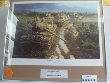
Print - A Framed Coloured Print of Centurion - "In Country", Centurion - "In Country", 2008
... Centurion "In Country" by Barry Spicer "As the breaking dawn pushed back the morning rain showers the unfolding soft light reveals a troop of Centurions of the Australian 1st Amoured regiment as they prepare to depart their first way point on another 'In Country operation'. Australian Army...Centurion "In Country" by Barry Spicer "As the breaking dawn pushed back the morning rain showers the unfolding soft light reveals a troop of Centurions of the Australian 1st Amoured regiment as they prepare to depart their first way point on another 'In Country operation'. Australian Army...National Vietnam Veterans Museum (NVVM) 25 Veterans Drive Newhaven phillip-island-and-the-bass-coast Centurion "In Country" by Barry Spicer "As the breaking dawn pushed back the morning rain showers the unfolding soft light reveals a troop of Centurions of the Australian 1st Amoured regiment as they prepare to depart their first way point on another 'In Country operation'. Australian Army ...Centurion "In Country" by Barry Spicer "As the breaking dawn pushed back the morning rain showers the unfolding soft light reveals a troop of Centurions of the Australian 1st Amoured regiment as they prepare to depart their first way point on another 'In Country operation'. Australian Army 1st Armoured Regiment Presentation copy.Coloured print of three Centurion tanks and 1 APC. All have personnel on or in them. They are accompanied by foot soldiers with arms drawn. Terrain is shrub, bush and palm trees. Sky cloud clearing. Silver Frame, Musk mat, Glass Frame. Under the print on white paper reads Australian Army. 1st Armoured RegimentCenturion "In Country" by Barry Spicer "As the breaking dawn pushed back the morning rain showers the unfolding soft light reveals a troop of Centurions of the Australian 1st Amoured regiment as they prepare to depart their first way point on another 'In Country operation'. Australian Army 1st Armoured Regiment Presentation copy.framed print, 1st armoured regiment, apc, centurion tank, barry spicer -
 Bendigo Military Museum
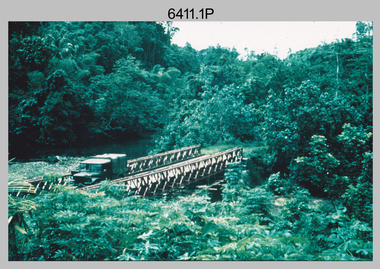
Photograph - RA Svy Project C4 Aerodist Operation, Eastern Arnhem Land, NT, 1967
... Australian Army’s equivalent featured in this photo set. These light observation helicopters had a limiting load carrying capacity of up to about 500 pounds. By comparison, one Aerodist team including two people weighed up to 1,500 pounds. Source: Royal Australian Survey Corps – Aerodist Years 1964-1975 by Peter Jensen. Refer to Item 9061.26P for more photos taken during this Aerodist survey operation...This is a set of 30 photographs of Royal Australian Survey Corps (RA Svy) personnel on Aerodist survey operations in Eastern Arnhem Land, Northern Territory in 1967. The photographs are on 35mm negative film and scanned at 96 dpi. They are part of the Army...Australian Army’s equivalent featured in this photo set. These light observation helicopters had a limiting load carrying capacity of up to about 500 pounds. By comparison, one Aerodist team including two people weighed up to 1,500 pounds. Source: Royal Australian Survey Corps – Aerodist Years 1964-1975 by Peter Jensen. Refer to Item 9061.26P for more photos taken during this Aerodist survey operation ...This is a set of 30 photographs of Royal Australian Survey Corps (RA Svy) personnel from Central Comd Fd Svy Unit (Adelaide) on Aerodist survey operation - Project C4 in Eastern Arnhem Land, Northern Territory in 1967. Photos of personnel were taken either at the operations base at Numbulwar or the main base at Gove (Nhulunbuy). RA Svy conducted nineteen Aerodist operations for 12 years from 1964 to 1975. Aerodist MRC2 was a tellurometer-based system adapted for aircraft to accurately measure distances between non-intervisible ground survey stations, using the aircraft as an intermediate station. Lower order geodetic results could be achieved by survey network trilateration. The measured distances between stations formed survey networks from which each station’s latitude and longitude was computed. Aerodist MRC2 was RA Svy’s major horizontal control survey tool for mainly medium scale topographic mapping (scale 1:100,000 Class A being spatially accurate to within 50 metres) in PNG, northern NT, north-west WA, Kalimantan Barat (West) Indonesia, Sumatra Indonesia, Gulf of Carpentaria and Cape York, QLD. In 1967, the Aerodist MRC2 Master equipment was installed in the aircraft featured in this set of photos, Executive Air Services’ (Essendon VIC) Grand Aero Commander VH-EXX. It was the same aircraft type and company contracted to Division of National Mapping for Aerodist MRC2 surveys. From July to October 1967 the aircraft was attached to Central Comd Fd Svy Unit (Adelaide - Major Don Ridge) on Project C4 eastern-Arnhem Land NT, where 317 Aerodist lines measuring 17,300 line miles were successfully completed. This was the most productive Aerodist project thus far. The most common helicopter used by RA Svy up to 1972 was the civilian Bell 47G-2 and the Sioux Light Observation Helicopters (LOH), the Australian Army’s equivalent featured in this photo set. These light observation helicopters had a limiting load carrying capacity of up to about 500 pounds. By comparison, one Aerodist team including two people weighed up to 1,500 pounds. Source: Royal Australian Survey Corps – Aerodist Years 1964-1975 by Peter Jensen. Refer to Item 9061.26P for more photos taken during this Aerodist survey operation.This is a set of 30 photographs of Royal Australian Survey Corps (RA Svy) personnel on Aerodist survey operations in Eastern Arnhem Land, Northern Territory in 1967. The photographs are on 35mm negative film and scanned at 96 dpi. They are part of the Army Survey Regiment’s Collection. .1) to .4) - black & white, 20th August 1967, Project C4 Aerodist Operations Base - Numbulwar, NT. .5) - Photo, black & white, 1967. Probable wrecked Indonesian fishing vessel. .6) to .8) - Photo, black & white, 1967. Unidentified survey operations base, L to R: unidentified personnel. .9) - Photo, black & white, 1967. Unidentified survey operations base, unidentified soldier driving a Haflinger 4x4 Light utility vehicle. .10) - Photo, black & white, 1967. Unidentified survey operations base, L to R: unidentified technician. .11) - Unidentified technician reading two survey altimeters to compute corrections to the measured distances for atmospheric refraction and to compute the sea level distances from the slope distances aircraft to the ground stations. .12) - Photo, black & white, 1967. Survey operations base, L to R: unidentified (x3), W01 Pat Wood BEM, unidentified. .13) to .16) - Photo, black & white, 1967. Unidentified personnel operating remote Aerodist MRC2 ground instruments. .17) to .18) - Photo, black & white, 1967. Unknown RA Svy office location. .19) to .20) - Photo, black & white, 1967. Aerodist MRC2 Master equipment. .21) to .22) - Photo, black & white, 1967. Aero Commander VH-EXX probably at Gove, NT, Central Comd Fd Svy Unit (Adelaide) – OC Major Don Ridge. .23) to .25) - Photo, black & white, 1967. Aero Commander VH-EXX probably at Gove, NT. Unidentified personnel. .26) - Photo, black & white, 1967. Aero Commander VH-EXX probably at Gove, NT. Aerodist antenna pods are visible on the aircraft. .27) to .29) - Photo, black & white, 1967. Australian Army Sioux Light Observation Helicopter (LOH) probably at Gove, NT. .30) - Photo, black & white, 1967. Panelled U337 survey station, visible as a white cross on aerial identification photo..1P to .2P – date and location on edge of film negative. .5P to .28P – no annotations .29P - annotated in white ‘RW-JEP Gove NT’ .30P - annotated in white ‘U337 Spool No1 Jun67’royal australian survey corps, rasvy, army survey regiment, army svy regt, fortuna, asr, aerodist, surveying, central comd fd svy unit -
 Bendigo Military Museum
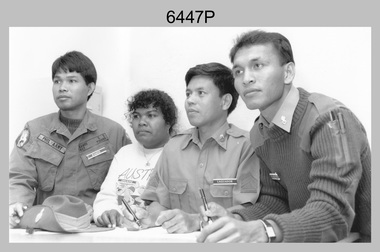
Photograph - Defence Co-operation Project Students, School of Military Survey, Bonegilla, VIC, 1990
... Bendigo Military Museum 37 - 39 Pall Mall Bendigo goldfields This is a photograph of Defence Co-operation Project (DCP) students from the Pacific region who attended the 1/90 Specialist Carto course held at the School of Military Survey, Bonegilla, Victoria from the 9th of May to the 5th of June 1990. Royal Australian Survey Corps RASvy Army ...This is a photograph of Defence Co-operation Project (DCP) students from the Pacific region who attended the 1/90 Specialist Carto course held at the School of Military Survey, Bonegilla, Victoria from the 9th of May to the 5th of June 1990.This is a photograph of Defence Co-operation Project (DCP) students attending the 1/90 Specialist Carto course held at the School of Military Survey, Bonegilla, Victoria in 1990. The photograph was printed on photographic paper and is part of the Army Survey Regiment’s Collection. The photograph was scanned at 300 dpi. .1) - Photo, black & white, 1990, DCP Students L to R: SGT Ramos – Philippines, Miss Chukeni – Solomon Islands, SGT Laguador – Philippines, CPL Jais – Malaysia. .1P – Students, course title and date annotated on back of photo.royal australian survey corps, rasvy, army survey regiment, army svy regt, school of military survey, fortuna, asr -
 Bendigo Military Museum
Administrative record - Army Survey Regiment - PNG JOG After Action Report Cartographic Sqn March 1982, DR Bowen, US Major, OC Carto Sqn, 22 Mar 1982
... Australian Survey Corps produced complete coverage of Papua New Guinea of Joint Operations Graphics (JOG) at 1:250,000 scale. JOG were produced in two versions JOG Ground in metres and JOG Air in feet. This report estimates the amount of manpower required to complete the last 30 x JOG and JOGA as at 22 March 1982 by Cartographic Squadron. Royal Australian Survey Corps RASvy Fortuna Army ...The Royal Australian Survey Corps produced complete coverage of Papua New Guinea of Joint Operations Graphics (JOG) at 1:250,000 scale. JOG were produced in two versions JOG Ground in metres and JOG Air in feet. This report estimates the amount of manpower required to complete the last 30 x JOG and JOGA as at 22 March 1982 by Cartographic Squadron.A4 typed 4 x page report stapled top LHSroyal australian survey corps, rasvy, fortuna, army survey regiment, army svy regt, asr, png -
 Bendigo Military Museum
Administrative record - 1 Fd Svy Sqn Project Report - Operation Carto Mercury 1986, 28 Jan 1986
... Bendigo Military Museum 37 - 39 Pall Mall Bendigo goldfields Operation Carto Mercury was a field completion Operation mounted by 1 Fd Svy Sqn 11 Aug 1985 to field complete 4 x 1:25000 compiled map sheet in the Cabarlah area to the North of Tawoomba. Included maps: 9243 - 23 Kingsthorpe, 9243 -24 Goombungee, 9243 - 21 Gomaren Creek, 9243 - 22 High Fields Royal Australian Survey Corps RASvy Fortuna Army Survey Regiment Army Svy Regt ASR 1 FD Svy Sqn A4 Typed document and diagrams, 14 pages. ...Operation Carto Mercury was a field completion Operation mounted by 1 Fd Svy Sqn 11 Aug 1985 to field complete 4 x 1:25000 compiled map sheet in the Cabarlah area to the North of Tawoomba. Included maps: 9243 - 23 Kingsthorpe, 9243 -24 Goombungee, 9243 - 21 Gomaren Creek, 9243 - 22 High FieldsA4 Typed document and diagrams, 14 pages. Report produced by 1 Fd Svy Sqn 1986royal australian survey corps, rasvy, fortuna, army survey regiment, army svy regt, asr, 1 fd svy sqn -
 Bendigo Military Museum
Magazine - "Parare" Survey Corps Magazine Issue 9, Royal Australian Survey Corps, 1993
... Australian Survey Corps Aerial photography Team personnel list page 95. Operation Belama 92 Team list page 96. Long term Schooling attendees and promotions, page 105. Litho Sqn Postings in and out pages 116-117. Special awards SGT Durrant page 113, SSGT SR Hill page 114. RASvy completes 1:50,000 scale mapping of the Pilbara Region page 121. 1st Topo Svy Sqn personnel mentioned on page 122. Army ...An annual magazine published for release on RASvy Corps birthday 1st July. All units with RASvy Corps are invited / expected to submit an article depicting their activities over the preceding years 1991 to 1993. 4Fd Svy Sqn Adventure training list pages 7, 8. Army Map Depot - Unit Ski Day, pages 20, 21. The William Patton Expedition - Locating his grave as part of the " Burke and Wills " expedition, list of personnel involved - page 43. 8 Fd Svy Sqn - names mentioned and photo - page 50. 4 Fd Svy Sqn (1992) names mentioned page 69. The G Res manning list on page 70. Names mentioned in "Unit sports pages 73, 74. Exercise Kokoda Cartographer July 1992 list of participants on Page 78. Iraq - The Gulf War, Topographic Support page 52. Adelaide (4 Fd Svy Sqn) 1992 page 65. 8 Fd Svy Sqn manning wind down list pages 89-90. Military Geographic Information Pilot Project page 92. Royal Australian Survey Corps Aerial photography Team personnel list page 95. Operation Belama 92 Team list page 96. Long term Schooling attendees and promotions, page 105. Litho Sqn Postings in and out pages 116-117. Special awards SGT Durrant page 113, SSGT SR Hill page 114. RASvy completes 1:50,000 scale mapping of the Pilbara Region page 121. 1st Topo Svy Sqn personnel mentioned on page 122. A4 sized booklet with soft glossy card covers, paper pages held together with a plastic spiral binder.army survey regiment, army survey regt, fortuna, royal australian survey corps, rasvy, asr -
 Bendigo Military Museum
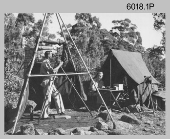
Photograph - Royal Australian Survey Corps Surveyors in the Field – Project Cutlass, New Guinea, 1956 – 1957
... In this survey operation surveyors used theodolites to observe horizontal and vertical angles and chains to measure base line distances between survey stations. Bob Skitch shown in photo .7P was in the 2nd year of his career in the Australian Army. ...Army Survey Regiment from 1976 to 1980. Royal Australian Survey Corps RASvy Army Survey Regiment Fortuna a Army Svy Regt ASR surveying .1P to .23P annotated on back – ‘Operation Cutlass’, personnel names, the year and the location. ...This is a set of 23 photographs of surveyors and support staff in the field undertaking tasks in New Guinea 1956 – 1957. The surveyors were employed in the establishment of mapping and geodetic control for Project Cutlass, the “Ship-Shore” survey of the New Ireland province. In this survey operation surveyors used theodolites to observe horizontal and vertical angles and chains to measure base line distances between survey stations. Bob Skitch shown in photo .7P was in the 2nd year of his career in the Australian Army. He achieved the rank of Lieutenant-Colonel, and his last appointment was the CO of the Army Survey Regiment from 1976 to 1980.This is a set of 23 photographs of surveyors and support staff in the field undertaking duties during Project Cutlass located in New Ireland, New Guinea 1956 – 1957. The photographs were printed on photographic paper and are part of the Army Survey Regiment’s Collection. The photographs were scanned at 300 dpi. .1) - Photo, colour, 1956. Surveyors travelling main road from Kavieng to Namatanai, New Ireland. .2) - Photo, colour, 1956. Unidentified surveyors assessing recovery of their vehicle after bridge collapsed on west side of New Ireland. .3) - Photo, colour, 1956. Unidentified surveyors assessing recovery of their vehicle after bridge collapsed over flooded creek on west side of New Ireland. .4) - Photo, colour, 1956. Survey personnel L to R: Bev Uwins, John Lambie, Bob Thompson, New Ireland. .5) - Photo, colour, 1956. Survey base camp, New Ireland. .6) - Photo, black & white, 1956-1957. Geoff Helsham with possible human remains, New Ireland. .7) - Photo, black & white, 1956-1957. Bob Skitch undertaking survey observations using Wild T2 theodolite, New Ireland. .8) - Photo, black & white, 1956-1957. Chas Beach undertaking survey observations using Wild T2 theodolite, New Ireland. .9) & .10) - Photo, black & white, 1956-1957. Kev Parker (cook) New Ireland. .11) - Photo, colour, 1957. Brian Berkery taking a break, Top Manor Island, Lihir Island Group off New Ireland. Latitude -2° 46”, Longitude 152° 40”. .12) - Photo, colour, 1957. Survey base camp L to R: Chas Beach, Bev Uwins, Feni Islands, New Ireland. Latitude -4° 05”, Longitude 153° 45”. .13) - Photo, colour, 1957. A Hous Kiap. (Kiaps, known formally as district officers and patrol officers, were travelling representatives of the British and Australian governments), New Ireland. .14) & .15) - Photo, colour, 1957. L to R: Joe Farrington, Tom Royle Bob undertaking survey observations using theodolites from an improvised timber tower, New Ireland. .16) & .17) - Photo, colour, 1957. US Army ship FS216 used for ship-to-shore triangulation docked at Rabaul, New Britain. .18) - Photo, colour, 1957. US Army ship FS216 used for ship-to-shore triangulation docked at Kavieng, New Ireland. Sight target on top of mast. .19) - Photo, colour, 1957. Survey personnel onboard US Army ship FS392, L to R: Peter Frodsham, Bob Thompson, Doc Reid, John Underwood, remainder unidentified, New Ireland. .20) - Photo, colour, 1957. Survey base line party heading ashore, New Ireland. .21) - Photo, colour, 1957. Survey personnel rowing US Army assault boat L to R: Kev Parker, Chas Beach, folded up survey beacons overhanging stern, New Ireland. .22) - Photo, colour, 1957. Les Bailey onboard US Army ship departing Rabaul, New Britain for Brisbane. .23) - Photo, colour, 1957. Ron Newman onboard US Army ship departing Rabaul, New Britain for Brisbane. Active volcano in background..1P to .23P annotated on back – ‘Operation Cutlass’, personnel names, the year and the location. royal australian survey corps, rasvy, army survey regiment, fortuna, a, army svy regt, asr, surveying -
 Bendigo Military Museum
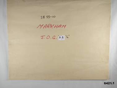
Map - SB55-10 Markham Joint Operations Graphics Air and Ground print separations, Royal Australian Survey Corps, Bendigo, Dec 1981
... Operations. The ground users required that heights and measurements were in Metres, whilst air users required height information in Feet for altimeters. The Air Version also contained more Aeronautical information including safe flying height information called Maximum Elevation Figures (MEF). Later printing of JOG incorporated printing in just four colours Cyan, Magenta, Yellow and Black (CMYK). Item 6421.1 is an example of a JOG Ground and item 6421.2 is an example of its matching JOG Air version. Royal Australian Survey Corps RASvy Fortuna Army ...This set of map prints was assembled as a training aid. The collection is a complete set of individual color prints of each colour used on the final printed maps for each map Joint Operations Graphic (JOG) JOG Ground and JOG Air versions. This map series was produced in two versions to help coordinate military Ground Operations and Air Operations. The ground users required that heights and measurements were in Metres, whilst air users required height information in Feet for altimeters. The Air Version also contained more Aeronautical information including safe flying height information called Maximum Elevation Figures (MEF). Later printing of JOG incorporated printing in just four colours Cyan, Magenta, Yellow and Black (CMYK). Item 6421.1 is an example of a JOG Ground and item 6421.2 is an example of its matching JOG Air version.1:250,000 SB55-10 Markham JOG A and G colour separations bound together in a manilla card covered folder bound with a timber edge. royal australian survey corps, rasvy, fortuna, army survey regiment, army svy regt, asr -
 Bendigo Military Museum
Photograph - Royal Australian Survey Corps Surveyors in the Field – PNG, 1962
... Australian Survey Corps RASvy Army Survey Regiment ASR Army Svy Regt Fortuna surveying .1P to .4P annotated on back – personnel names, the year and the location. This is a set of four photographs of surveyors and support staff in the field undertaking duties in PNG in 1962. The photographs were printed on photographic paper and are part of the Army Survey Regiment’s Collection. The photographs were scanned at 300 dpi. .1) - Photo, colour, 1962. Unloading survey operation ...This is a set of four photographs of surveyors and support staff in the field undertaking duties in Dogera, Milne Bay Province and Kerema, Gulf Province of PNG in 1962. The surveyors were employed in the establishment of mapping and geodetic control. In this era surveyors used theodolites to observe horizontal and vertical angles and tellurometers to measure base line distances between survey stations. From 1957 helicopter transport of survey parties revolutionised transport in remote areas.This is a set of four photographs of surveyors and support staff in the field undertaking duties in PNG in 1962. The photographs were printed on photographic paper and are part of the Army Survey Regiment’s Collection. The photographs were scanned at 300 dpi. .1) - Photo, colour, 1962. Unloading survey operation stores from a Landing Ship Medium (LSM) at Dogera, Milne Bay Province, PNG. .2) & .3) - Photo, colour, 1962. Hired civilian helicopter Bell 47G-2 helicopters operating at at Dogera, Milne Bay Province, PNG. .4) - Photo, colour, 1962. Survey party at survey station located near Kerema, Gulf Province southern PNG. L to R: Dave Owens, Keith Broadbent, with local villagers in background..1P to .4P annotated on back – personnel names, the year and the location. royal australian survey corps, rasvy, army survey regiment, asr, army svy regt, fortuna, surveying -
 Bendigo Military Museum
Administrative record - Joint Committee for the exchange of Information on ADP within the RASvy Corps, Activities Jun- Dec 1985, Army Survey Regiment, December 1985
... operation of the Royal Australian Survey Corps Mapping capability and production. This paper describes elements of the ADP with a comprehensive description of each. They Include, PDP 11/70 Memory, Map Stock Control System, Digital Terrain Elevation Data, Digital Terrain Model Package, ASMAPS, ASTIS, Reflectance Hill Shading, Aerial Triangulation and Terrain Analysis. Royal Australian Survey Corps RASvy Fortuna Army ...Automated Computer Processing (ADP) was instrumental to the successful operation of the Royal Australian Survey Corps Mapping capability and production. This paper describes elements of the ADP with a comprehensive description of each. They Include, PDP 11/70 Memory, Map Stock Control System, Digital Terrain Elevation Data, Digital Terrain Model Package, ASMAPS, ASTIS, Reflectance Hill Shading, Aerial Triangulation and Terrain Analysis.Two page paper report about Automated Data Processing, unstapledHand annotated "Folio 74" in top right hand cornerroyal australian survey corps, rasvy, fortuna, army survey regiment, army svy regt, asr -
 Bendigo Military Museum
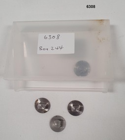
Equipment - Tri punched Film Registration System - stainless steel (studs), Ordinance Factory Bendigo, Circa 1960
... Royal Australian Survey Corps RASvy Fortuna Army Survey Regiment Army Svy Regt ASR Precision engineered stainless steel studs (pins) Set of three required for operation, includes a spare stud all stored in a plastic container. ...These studs (pins) were used in the manual production of mapping to accurately register a number of sheets of film reproduction material together. A set of three studs were required. This simple but effective system allowed the reproduction material layers (repromat) to expand and contract with changes in temperature whilst maintaining the registration between sheets.Precision engineered stainless steel studs (pins) Set of three required for operation, includes a spare stud all stored in a plastic container. These studs were also produced as a low profile version for use in large format photographic vacuum contact frames so that they would not break the glass.royal australian survey corps, rasvy, fortuna, army survey regiment, army svy regt, asr -
 Bendigo Military Museum
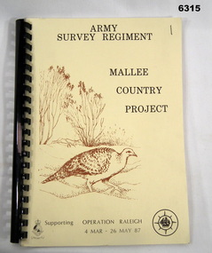
Administrative record - Army Survey Regiment - Mallee Country Project, Army Survey Regiment, 30.01.1987
... Operation Raleigh is a scheme for International Venturers (Scouts) to develop leadership, self-reliance, initiative and team work while studying Mallee Fowl, Mammal Trapping and Cross Country Trekking. Four Annexes containing sketch maps, personnel lists, photographs and stores lists. Royal Australian Survey Corps RASvy Fortuna Army ...This is a reconnaissance report for the Mallee Country Project supporting Operation Raleigh 4 Mar - 26 May 1987. Operation Raleigh is a scheme for International Venturers (Scouts) to develop leadership, self-reliance, initiative and team work while studying Mallee Fowl, Mammal Trapping and Cross Country Trekking. Four Annexes containing sketch maps, personnel lists, photographs and stores lists.A4 Report, soft covers front and back. Plastic ring bindingroyal australian survey corps, rasvy, fortuna, army survey regiment, army svy regt, asr -
 Bendigo Military Museum
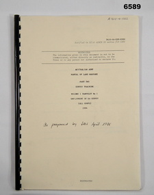
Pamphlet - Manual of Land Warfare - Employment of RASvy - Survey Training, School of Military Survey, Bonegilla, Vic, 1984
... operations and in the support area. It outlines the roles, characteristics and tasks of RASvy units and elements, but no attempt has been made to detail staff or technical procedures. The document being a draft, contains many blank pages for additional information to be added prior to publication. RASvy was disbanded in 1996. Royal Australian Survey Corps RASvy Fortuna Army ...This document is a draft proposal by the School of Military Survey (SMS) for the Manual of Land Warfare Volume 1, Phamphlet No1 - Employment of RASvy - Part 2, Survey Training 1984. The pamphlet describes the responsibilities and principles of employment of RASvy units and elements in the area of operations and in the support area. It outlines the roles, characteristics and tasks of RASvy units and elements, but no attempt has been made to detail staff or technical procedures. The document being a draft, contains many blank pages for additional information to be added prior to publication. RASvy was disbanded in 1996.45 x page A4 paper pamphlet containing text and diagrams. Buff coloured light card covers with a plastic comb binding.On the front cover: "A 7610 -14 - 1332" "As proposed by SMS April 1985"royal australian survey corps, rasvy, fortuna, army survey regiment, army svy regt, asr, school of military survey -
 Bendigo Military Museum
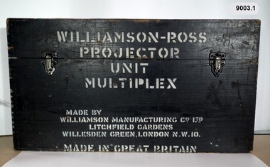
Instrument - Multiplex Unit Projector, Williamson Manufacturing Co, Circa 1950
... Australian Survey Corps RASvy Fortuna Army Survey Regiment Army Svy Regt WILLIAMSON MANUFACTURING CO, PHOTOGRAPHIC ENGINEERS, SERIAL NUMBER 3437, TYPE MPC, LITCHFIELD GARDENS, LONDON AND READING. A black wooden box containing a Multiplex Unit Projector (incomplete). The Multiplex has a Lamp Head, Barrel Housing, Body of the Projector and a Platen which is missing. .1 Protective wooden box .2 Multiplex Instrument .3 Multiplex Instrument Parts Diagram .4 A bank of Multiplex projectors in operation Multiplex Unit Projector Instrument Multiplex Unit Projector Williamson Manufacturing Co ...Multiplex mechanical stereoplotting equipment was used at the Army Survey Regiment, Fortuna Bendigo. c1950s. Multiplex equipment was imported from the UK in 1951 and introduced in the following year, to accelerate map production output covering CMF training areas at 1:25,000 map scale. Multiplex plotting was a productive advancement replacing the ‘Arundel’ method of graphical plotting planimetric detail that was expensive and slow, especially in timbered mountainous terrain. Air photos were made into small diapositives and mounted on racks in the exact position relative to when the aerial photos were taken. The technicians operated the Multiplex in a darkened room, with one photo projected with a green filter and the other through a red filter to form a 3D view of the overlapping photos. The 3D model projected onto a platen, which was a small platform that was raised up and down. The technician viewed the 3D image with special glasses fitted with red and green lenses. In the centre of the platen was a small pinhole that served as a floating mark, with a vertical pencil located exactly below the pinhole. This tracing table was moved to follow the topographic feature or contour line and draw it on the paper underneath. The technician raising or lowering the platform’s floating mark to match the height of the 3D terrain. It also replaced the slotted template method of mechanical adjustment of strips of aerial photography, however was restricted to each strip rather than between strips in the block. Although the Multiplex was phased out of production in 1968, it was used in the training of photogrammetry and aero-triangulation at the School of Military Survey located at Bonegilla, Victoria until the early 1990s. The history of the Multiplex is covered in more detail with additional historic photographs, in pages 50 to 51 of Valerie Lovejoy’s book 'Mapmakers of Fortuna – A history of the Army Survey Regiment’ ISBN: 0-646-42120-4. This instrument is only one of the projectors of a set and is unfortunately missing its platen, coloured filters and coloured glasses. Another instrument is in the collection as Item 9039.4A black wooden box containing a Multiplex Unit Projector (incomplete). The Multiplex has a Lamp Head, Barrel Housing, Body of the Projector and a Platen which is missing. .1 Protective wooden box .2 Multiplex Instrument .3 Multiplex Instrument Parts Diagram .4 A bank of Multiplex projectors in operation WILLIAMSON MANUFACTURING CO, PHOTOGRAPHIC ENGINEERS, SERIAL NUMBER 3437, TYPE MPC, LITCHFIELD GARDENS, LONDON AND READING.royal australian survey corps, rasvy, fortuna, army survey regiment, army svy regt -
 Bendigo Military Museum
Photograph - Royal Australian Survey Corps Surveyors in the Field, Army Survey Regiment, 1950s to 1970s
... operations or the surveyors may have been in training. Photo .1P was possibly taken at Mount Alexander in Central Victoria, a location close to Bendigo, as the stone cairn in the background of the photo appears to be identical to the cairn presently located on top of the mountain. Personnel and location have been confirmed on another photo in the collection with annotation. Royal Australian Survey Corps RASvy Army ...These three photographs were most likely taken from the 1950s to the 1970s. The RASvy surveyor in each photograph was taking angular measurements with the observer recording their readings on a booking form. They were probably employed in establishing mapping and geodetic control operations or the surveyors may have been in training. Photo .1P was possibly taken at Mount Alexander in Central Victoria, a location close to Bendigo, as the stone cairn in the background of the photo appears to be identical to the cairn presently located on top of the mountain. Personnel and location have been confirmed on another photo in the collection with annotation. These three photographs are of surveyors in the field undertaking observations using theodolites. The photographs were printed on photographic paper and are part of the Army Survey Regiment’s Collection. The photographs were scanned at 300 dpi. .1) - Photo, black & white, c1950s. Unidentified personnel undertaking observations with a Tavistock geodetic theodolite. .2) – Photo, colour, mounted on card, c1960s. Unidentified personnel undertaking observations with a Kern DKM2 theodolite. .3) - Photo, colour, c1970s. Unidentified personnel undertaking observations with a theodolite..1 – not annotated .2 –annotated on front “Kern DKM2, TOPO 10” royal australian survey corps, rasvy, army survey regiment, army svy regt, fortuna, asr, surveying -
 Bendigo Military Museum
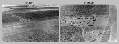
Photograph - RA Svy Project C4 Aerodist Operation, Eastern & Western Arnhem Land, NT, 1967, 1968
... Australian Army’s equivalent featured in this photo set. These light observation helicopters had a limiting load carrying capacity of up to about 500 pounds. By comparison, one Aerodist team including two people weighed up to 1,500 pounds. In 1968, after completion of the Kimberley Aerodist Operation...This is a set of 26 photographs of Royal Australian Survey Corps (RA Svy) personnel on Aerodist survey operations in Eastern Arnhem Land, Northern Territory in 1967 and Western Arnhem Land, Northern Territory in 1968. The photographs are on 35mm negative film and scanned at 96 dpi. They are part of the Army...Australian Survey Corps – Aerodist Years 1964-1975 by Peter Jensen. Refer to Item 6449.30P for more photos taken during these Aerodist survey operations. Royal Australian Survey Corps RASvy Army ...This is a set of 26 photographs of Royal Australian Survey Corps (RA Svy) personnel from Central Comd Fd Svy Unit (Adelaide) on Aerodist survey operation - Project C4 in Eastern Arnhem Land, Northern Territory in 1967 (photos .4P to .26P) and in Western Arnhem Land, Northern Territory in 1968 (photos .1P to .3P). Photos of personnel were taken either at the operations base at Numbulwar or the main base at Gove (Nhulunbuy). RA Svy conducted nineteen Aerodist operations for 12 years from 1964 to 1975. Aerodist MRC2 was a tellurometer-based system adapted for aircraft to accurately measure distances between non-intervisible ground survey stations, using the aircraft as an intermediate station. Lower order geodetic results could be achieved by survey network trilateration. The measured distances between stations formed survey networks from which each station’s latitude and longitude was computed. Aerodist MRC2 was RA Svy’s major horizontal control survey tool for mainly medium scale topographic mapping (scale 1:100,000 Class A being spatially accurate to within 50 metres) in PNG, northern NT, north-west WA, Kalimantan Barat (West) Indonesia, Sumatra Indonesia, Gulf of Carpentaria and Cape York, QLD. In 1967, the Aerodist MRC2 Master equipment was installed in the aircraft featured in this set of photos, Executive Air Services’ (Essendon VIC) Grand Aero Commander VH-EXX. It was the same aircraft type and company contracted to Division of National Mapping for Aerodist MRC2 surveys. From July to October 1967 the aircraft was attached to Central Comd Fd Svy Unit (Adelaide - Major Don Ridge) on Project C4 eastern-Arnhem Land NT, where 317 Aerodist lines measuring 17,300 line miles were successfully completed. This was the most productive Aerodist project thus far. The most common helicopter used by RA Svy up to 1972 was the civilian Bell 47G-2 and the Sioux Light Observation Helicopters (LOH), the Australian Army’s equivalent featured in this photo set. These light observation helicopters had a limiting load carrying capacity of up to about 500 pounds. By comparison, one Aerodist team including two people weighed up to 1,500 pounds. In 1968, after completion of the Kimberley Aerodist Operation project, the Aerodist system in VH-EXX was immediately deployed to western-Arnhem Land NT for Central Comd Fd Svy Unit (Adelaide - Major Don Ridge) to complete the mapping control across northern NT from mid-July to October. The Aerodist MRC2 Remote antenna seen in Photos .24P to .26P is mounted on a 20 foot pole tower. The antenna direction was controlled by wires/ropes to the two arms under the dish at right angles. The antenna elevation could be changed to the vertical for aircraft height checks as seen in photo .25P. Source: Royal Australian Survey Corps – Aerodist Years 1964-1975 by Peter Jensen. Refer to Item 6449.30P for more photos taken during these Aerodist survey operations.This is a set of 26 photographs of Royal Australian Survey Corps (RA Svy) personnel on Aerodist survey operations in Eastern Arnhem Land, Northern Territory in 1967 and Western Arnhem Land, Northern Territory in 1968. The photographs are on 35mm negative film and scanned at 96 dpi. They are part of the Army Survey Regiment’s Collection. .1) to .2) – Photo, black & white, 1968, unidentified soldier with an opened can of food, possibly bully beef. .3) – Photo, black & white, 15 Aug 1968, aerial view of terrain taken from a helicopter in vicinity of MILINGIMBI SIERRA. .4) – Photo, black & white, 1967, aerial view of an island taken from a helicopter. .5) & .6) – Photo, black & white, 1967, unidentified soldier driving a Haflinger 4x4 Light utility vehicle with trailer. .7) – Photo, black & white, 1967, unidentified surveyors taking vertical measurements with a leveling instrument and staff. .8) – Photo, black & white, 1967, Australian Army Sioux Light Observation Helicopter (LOH) with float removed. .9) to .11) – Photo, black & white, 1967, Australian Army Sioux Light Observation Helicopter (LOH) with floats. .12) – Photo, black & white, 1967, civilian Bell 47G-2 helicopter (Australian Army Sioux LOH equivalent) refuelled. .13) – Photo, black & white, 1967, survey station on coastline surrounded by white plastic aerial photographic identification panels lined with rocks. .14) & .15) – Photo, black & white, 1967, soldier (possibly a signaller from RA Sigs) operating a radio. .16) – Photo, black & white, 1967, Central Comd Fd Svy Unit Operations Section tent, Main Base Gove (Nhulunbuy) L to R: SPR Harry Dunn, WO1 Pat Wood BEM. .17) – Photo, black & white, 1967, Central Comd Fd Svy Unit Operations Section tent, Main Base Gove (Nhulunbuy) L to R: unidentified, WO1 Pat Wood BEM. .18) – Photo, black & white, 1967, Central Comd Fd Svy Unit Operations Section, Main Base Gove (Nhulunbuy), unidentified Australian Army Catering Corps cook preparing meals. .19) – Photo, black & white, 1967, Central Comd Fd Svy Unit Operations Section, Main Base Gove (Nhulunbuy) mess tent in readiness for meals. .20) – Photo, black & white, 1967, Bank of batteries in transit boxes undergoing recharging using generators. .21) – Photo, black & white, 1967, A topographic survey identification plaque set in a concrete block being weighed using a set of scales hanging from slaughtering gallows. .22) – Photo, black & white, 1967, CPL (Geoff or Gary) Larkin operating the remote Aerodist MRC2 ground instrument at Veronica Island, located north of Nhulunbuy. .23) – Photo, black & white, 1967, L to R: CPL (Geoff or Gary) Larkin with unidentified surveyor operate the remote Aerodist MRC2 ground instrument at Venica Island, located north of Nhulunbuy. .24) & .25 – Photo, black & white, 1967, The Aerodist MRC2 Remote antenna. .26) – Photo, black & white, 1967, The Aerodist MRC2 Remote antenna.The following photos are annotated in black ink on edge of film negative: .3P – ’15 Aug ’68, 2000’, 1-C18 ’68 MILINGIMBI SIERRA’ .4P – ’U462’ .8P – ‘1-C3/67 Float Removed’ .13P – ‘U477 10-C3/67 .20P - ‘2-C3/67 Bank of Chargers’ .21P - ‘3-C3/67 Gallows & Scales’ .22P - ‘0462 VERONICA ISLAND NT, CPL Larkin’ .23P - ‘0462 VERONICA ISLAND NT’ .24P - ‘4-C3/67 20’ Aerodist Tower’ .25P - ‘5-C3/67 20’ Aerodist Tower’ .26P - ‘6-C3/67 20’ Aerodist Tower’royal australian survey corps, rasvy, army survey regiment, army svy regt, fortuna, asr, aerodist, surveying, central comd fd svy unit -
 Bendigo Military Museum
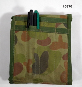
Equipment - WALLET, TACTICAL FIELD ORGANISER, ARMY, Australian Defence Industries, c. 1980's
... ARMY DRIVING LICENCE" folded into a small clear plastic document pocket. CANVAS WALLET POCKETS - INTERIOR front - "LAYOUT OF OPERATION ORDER FOR ROAD MOVEMENT" - 4 pages laminated in clear plastic. - Back - "AIDE MEMOOOOOIRE/ NAVIGATOR" - 8 pages stapled. - "Department of Defence NOTEBOOK" with handwritten notes. EXTERIOR - 4 channel pockets - two ink permanent marker pens - black and green ink. Equipment WALLET, TACTICAL FIELD ORGANISER, ARMY Australian ...Uniform issued to D. Hutchinson.Tactical Field Organiser Wallet. Wallet - Canvas fabric with Disruptive Pattern Camouflage Uniform colour of greens and browns. Dark green cotton twill binding to edges and to two interior pockets and one exterior 4 channel pocket. Inner green hard plastic folder with attached clear document pockets. Manufacturers label - green poly cotton fabric. Velcro tape closer to wallet. Wallet contains the following paperwork and items. Document pockets; -"CONVOY/ PRELIMINARY ORDERS" 11 pages. - Handwritten notes, 2 pages folded, 5 pages folded. 6 pages folded. - Notepad paper - 8 pages folded. - "ARMY SCHOOL OF TRANSPORT"/ AIDE MEMOIRS/ RADIO TELEPHONE PROCEDURE" - print on yellow paper folded. - "ARMY SCHOOL OF TRANSPORT/ CORPS TRAINING WING/ DISTRIBUTION POINT" - 8 PAGES, - "RESTRICTED/ RACT CENTRE/ CORPS TRAINING WING/ TROOP LIFTING" - 5 pages stapled. - "OP OCCUPATION ORDERS" - 11 pages. - "ARMY DRIVING LICENCE" folded into a small clear plastic document pocket. CANVAS WALLET POCKETS - INTERIOR front - "LAYOUT OF OPERATION ORDER FOR ROAD MOVEMENT" - 4 pages laminated in clear plastic. - Back - "AIDE MEMOOOOOIRE/ NAVIGATOR" - 8 pages stapled. - "Department of Defence NOTEBOOK" with handwritten notes. EXTERIOR - 4 channel pockets - two ink permanent marker pens - black and green ink. Manufacturer's details - black ink print. "DDC SUPPLY LINE/ MELBOURNE".d hutchinson, equipment, army, wallet, dpcu -
 Bendigo Military Museum
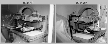
Photograph - Removal of AUTOMAP 1’s Gerber Optical Line Following (OLF) scanner from Army Survey Regiment, Fortuna, Bendigo, c1982-1983
... Army Survey Regiment’ ISBN: 0-646-42120-4. See items 6122.20P, 6183.19P, and 6184.20P for additional photographs of AUTOMAP 1’s Gerber OLF in operation. Royal Australian ...This collection of eight photos was most likely taken in circa 1982-1983, featuring the removal of AUTOMAP 1’s Gerber Optical Line Following (OLF) scanner Sub-System from Air Survey Squadron’s Building 16, in preparation for the installation of the replacement AUTOMAP 2 system. Introduced in 1975, the AUTOMAP 1 computer assisted cartography and mapping system was the first computer assisted cartography and mapping system utilised by the Survey Corps and the first system used by Australian mapping organisations. The Gerber OLF scanner was mainly used to digitise contours on a map sheet separation with individual lines at least 0.125 mm wide and no closer than 0.25 mm to the next line. The operator initiated the OLF by placing its light sensitive digitizing head on a contour line. The OLF could digitise up to 50 mm per second on straight lines and complete an average density contour sheet in approximately 8 hours. The operator occasionally intervened to restart the OLF to allow it to continue if it failed to correctly discriminate the contours. The history of the AUTOMAP 1 system is covered in more detail with additional historic photographs, in pages 116-118 of Valerie Lovejoy’s book 'Mapmakers of Fortuna – A history of the Army Survey Regiment’ ISBN: 0-646-42120-4. See items 6122.20P, 6183.19P, and 6184.20P for additional photographs of AUTOMAP 1’s Gerber OLF in operation.This is a set of eight photographs of the removal of AUTOMAP 1’s Gerber Optical Line Following (OLF) scanner Sub-System from Air Survey Squadron’s Building 16, at the Army Survey Regiment at Fortuna, Bendigo, circa 1982-1983. The photographs are on 35mm negative film and scanned at 96 dpi. They are part of the Army Survey Regiment’s Collection. .1) to .8) - Photo, black & white, c1982-1983, - Gerber Optical Line Follow (OLF) removal from Air Survey Squadron’s Building 16..1P to .8P – There are no annotationsroyal australian survey corps, rasvy, fortuna, army survey regiment, automap 1 -
 Bendigo Military Museum
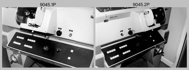
Photograph - Superseded AUTOMAP 1 Equipment, Army Survey Regiment, Fortuna, Bendigo, c1983
... Australian mapping organisations. The replacement AUTOMAP 2 system achieved operational status in August 1983. The history of the AUTOMAP 1 system is covered in more detail with additional historic photographs, in pages 116-118 of Valerie Lovejoy’s book 'Mapmakers of Fortuna – A history of the Army Survey Regiment’ ISBN: 0-646-42120-4. See items 6122.20P, 6183.19P, and 6184.20P for additional photographs of AUTOMAP 1’s system and the B8 Stereoplotters in operation...Australian mapping organisations. The replacement AUTOMAP 2 system achieved operational status in August 1983. The history of the AUTOMAP 1 system is covered in more detail with additional historic photographs, in pages 116-118 of Valerie Lovejoy’s book 'Mapmakers of Fortuna – A history of the Army Survey Regiment’ ISBN: 0-646-42120-4. See items 6122.20P, 6183.19P, and 6184.20P for additional photographs of AUTOMAP 1’s system and the B8 Stereoplotters in operation ...This set of eight photographs of superseded AUTOMAP 1 equipment was taken at the Army Survey Regiment, Fortuna, Bendigo, circa 1983. The photos were taken in one of the Q-store buildings. Introduced in 1975, the AUTOMAP 1 computer assisted cartography and mapping system was the first computer assisted cartography and mapping system utilised by the Survey Corps and the first system used by Australian mapping organisations. The replacement AUTOMAP 2 system achieved operational status in August 1983. The history of the AUTOMAP 1 system is covered in more detail with additional historic photographs, in pages 116-118 of Valerie Lovejoy’s book 'Mapmakers of Fortuna – A history of the Army Survey Regiment’ ISBN: 0-646-42120-4. See items 6122.20P, 6183.19P, and 6184.20P for additional photographs of AUTOMAP 1’s system and the B8 Stereoplotters in operation. This set of eight photographs of superseded AUTOMAP 1 Equipment was taken at the Army Survey Regiment, Fortuna, Bendigo, circa 1983. The photographs are on 35mm negative film and scanned at 96 dpi. They are part of the Army Survey Regiment’s Collection. .1) to .8) - Photo, black & white, c1983, superseded AUTOMAP 1 B8 Stereoplotters and equipment in storage awaiting disposal..1P to .8P – There are no annotationsroyal australian survey corps, rasvy, fortuna, army survey regiment, automap 1 -
 Bendigo Military Museum
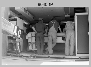
Photograph - Aerotriangulation Production – Army Survey Regiment, Fortuna, Bendigo, c1989
... See item 6195.19P for more photos of aerotriangulation equipment and their operation in map production. Royal Australian Survey Corps RASvy Fortuna Army Survey Regiment air survey aerotrig .1P to .17P – There are no annotations This is a set of 17 photographs of Air Survey Squadron aerotriangulation equipment and personnel taken at the Army Survey Regiment at Fortuna, Bendigo, circa 1989. ...This collection of 17 photographs of Air Survey Squadron aerotriangulation equipment and personnel was taken at the Army Survey Regiment, Fortuna, Bendigo, circa 1989. The PDP 11/70 minicomputer was the operating system introduced in 1977 as the mainframe system for the control of the APC4, aerial triangulation block adjustments, SORA OP Analytical Orthophoto control, APR Analytical Terrain Profile Recorder computation, graphics, and general computing. The OMI/Nistri AP/C-3 analytical plotter shown in photo .1P to .6P and .9P was introduced in 1972–1973. The Zeiss (Jena) Stecometer analytic stereocomparator for air photography shown in photo .16P was introduced at Air Survey Squadron in 1963. Aerotriangulation production was expedited using computers for analytical photogrammetric processes. The technician accurately measured between pass, tie, and survey control points on aerial photographs. Wild PUG4 point transfer devices as shown in photo .17P, were introduced in c1968 superseding the PUG2 devices. PUG4 devices were used by technicians to stereoscopically view the photography containing the survey control points and the mapping aerial photography. The Control points were transferred from the control photography to the mapping diapositives of aerial photography by drilling their locations into the photographic emulsion. See item 6195.19P for more photos of aerotriangulation equipment and their operation in map production.This is a set of 17 photographs of Air Survey Squadron aerotriangulation equipment and personnel taken at the Army Survey Regiment at Fortuna, Bendigo, circa 1989. The photographs are on 35mm negative film and scanned at 96 dpi. They are part of the Army Survey Regiment’s Collection. .1) to .7) - Photo, black & white, c1989, OMI/Nistri APC/3-1 analytical stereoplotter. .8) - Photo, black & white, c1989, miscellaneous aerotriangulation equipment. .9) to.10) - Photo, black & white, c1989, Digital Equipment Corporation (DEC) 11 VO3-L Superminicomputer, with VT52 DECScope terminal. .11) to .15) - Photo, black & white, c1989, miscellaneous aerotriangulation equipment. .16) - Photo, colour, c1989, Zeiss (Jena) Stecometer, unidentified technician. .17) - Photo, black & white, c1989, Wild PUG4 point transfer device, unidentified technician..1P to .17P – There are no annotationsroyal australian survey corps, rasvy, fortuna, army survey regiment, air survey, aerotrig