Showing 86 items matching "australian atlas"
-
 Kiewa Valley Historical Society
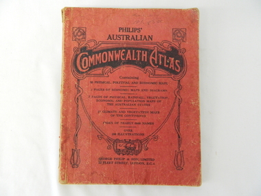
Atlas Australian Commonwealth, Philips' Australian Commonwealth Atlas, 1944
... Atlas Australian Commonwealth...Philips' Australian Commonwealth Atlas......australian atlas...This atlas, printed in 1944, details not only the geographic and political boundaries of the world as it was at that time but also the snap shot of life of the time. This snap shot in time covers the major Australian...The atlas contain 56 pages of world and Australian maps, vegetation and rainfall maps. ...On front cover "Philips' Australian COMMONWEALTH ATLAS" and underneath "Containing" underneath "60 PHYSICAL, POLITICAL AND ECONOMIC MAPS". ...Philips' Australian Commonwealth Atlas Atlas Australian Commonwealth George Philip & Son, Ltd ...This atlas, printed in 1944, details not only the geographic and political boundaries of the world as it was at that time but also the snap shot of life of the time. This snap shot in time covers the major Australian cities, the major farming, grazing, industrial and sporting/recreational activities. Also there are snap shots of similar activities from other global areas. The period also covered World War II, detailed by a photo of "shell making", munitions, required by Australian soldiers. The great political and territorial changes made as a result of World War II can be clearly identified for example , Israel (the Jewish homeland). The various prewar colonies of major European nations.This atlas was used by children of a Kiewa Valley family and shows the value and the general educational exposure that these children had at this time. The rural setting and within the backdrop of a world war did not severely alter the life style of children in this region. The "news reels" shown in cinemas of cities and larger towns were the only visual realisations of major events of global significance available to these children. The information provided by this atlas allowed students to glimpse at what the "outside world" was. The majority of these students would possibly never see these regions for themselves. The great communication facilities of the late 1900s and beyond, was still only science fiction.This atlas has a thick (350 g/m) red cardboard cover with bold black lettering and shading. The cover is set out within a shield like frame. The shield is held up by two square markings, each with a four part circular pattern and a cord entwining two pendulum structures ending with a bowl figure at the bottom. There is a semi circular form enclosing a printed book contents list. The inside cover has the atlas title and contents and the publisher details. The atlas contain 56 pages of world and Australian maps, vegetation and rainfall maps. Within this atlas there are 27 double sided pages of black and white photographs depicting life styles, buildings, landscapes and prominent and significant to Australia males from 1652 to 1944. The pages are of approximately 200 g/m and have the yellow aged appearance.On front cover "Philips' Australian COMMONWEALTH ATLAS" and underneath "Containing" underneath "60 PHYSICAL, POLITICAL AND ECONOMIC MAPS". Publisher George Philip & Son, Limited 32 Fleet Street, London E.C. 4. Inside cover are: written, in freehand and in ink the following names and dates; "J.Muller Form V 1945", "L L Muller Form IV 1946", "N.J. Muller Form I + II + III 1948 +49 + 50" and "D Muller Form I 1949". also handwritten and in pencil is "Peter Leslie". On the last page is a small freehand sketch of Australia in biro.1940s school curriculum, rural education, 1940s atlas, australian atlas -
 Kiewa Valley Historical Society
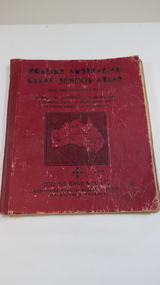
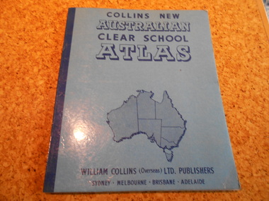
Book - Educational - School Atlas, Collins' Australian Clear School Atlas
... Collins' Australian Clear School Atlas...australian school atlas...Australian schools used Atlases to teach students geography and the nationalities of countries worldwide....Circa 1950s Collins' Australian Clear School Atlas Book - Educational - School Atlas ...Australian schools used Atlases to teach students geography and the nationalities of countries worldwide.Clare Roper was a resident of the Kiewa Valley. This atlas is of interest because it is circa 1950s and shows the world at this time.Thick red cardboard cover with black print and map of Australia on cover. It includes coloured maps of countries, black & white photos and an index at the back. On the inside of the cover both front and back it has black and white maps. There are 30 pages and it is bound. Circa 1950sCover page: handwritten "Margaret Tulloh / C. Roper / Margaret Tulloh / M.L.C. Some pages have been marked with pencilaustralian school atlas, clare roper -
 Numurkah & District Historical Society
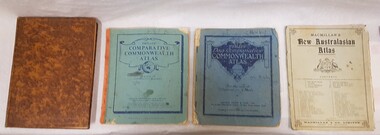
Book - School Atlases, Macmillan's New Australian Atlas / Phillip's New Comparitive Commonwealth Atlas (2) / The New Pictorial Atlas of the World
... Macmillan's New Australian Atlas / Phillip's New Comparitive Commonwealth Atlas (2) / The New Pictorial Atlas of the World...Cardboard covers & paper pages Macmillan's New Australian Atlas / Phillip's New Comparitive Commonwealth Atlas (2) / The New Pictorial Atlas of the World Book School Atlases ...4 x World Atlas book. Cardboard covers & paper pagessee photoeducation, school, atlas, geography -
 Victorian Railway History Library
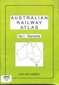
Book, Quail Map Company, Australian Railway Atlas No.1 - Tasmania, 2004
... Australian Railway Atlas No.1 - Tasmania...Victorian Railway History Library 39 St Edmonds Rd Prahran Prahran Railway and tramway maps - Tasmania Railway operations - Tasmania - history Railway and tramway maps of Tasmania both government and private railways index, maps, p.33. Australian Railway Atlas No.1 - Tasmania Book Quail Map Company ...Railway and tramway maps of Tasmania both government and private railwaysindex, maps, p.33.non-fictionRailway and tramway maps of Tasmania both government and private railwaysrailway and tramway maps - tasmania, railway operations - tasmania - history -
 Robin Boyd Foundation
Book, Edgar Ford, Collins New Australian Clear School Atlas, 1965
... Collins New Australian Clear School Atlas...Robin Boyd Foundation 290 Walsh Street South Yarra melbourne Geography Walsh St library Softcover Collins New Australian Clear School Atlas Book Edgar Ford William Collins ...Softcovergeography, walsh st library -
 Victorian Railway History Library
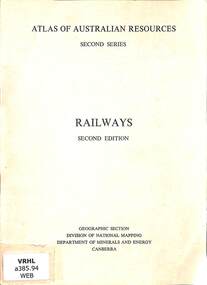
Booklet, Commonwealth of Australia, Atlas of Australian Resources: Second Series Railway Second Edition, 1975
... Atlas of Australian Resources: Second Series Railway Second Edition...Victorian Railway History Library 39 St Edmonds Rd Prahran Prahran Railroad operations - Australia - history Railroad statistics - Australia Details of Australian railway resources prepared by the Commonwealth Government in 1975. p.22. Atlas of Australian Resources: Second Series Railway Second Edition Booklet Commonwealth of Australia ...Details of Australian railway resources prepared by the Commonwealth Government in 1975.p.22.non-fictionDetails of Australian railway resources prepared by the Commonwealth Government in 1975.railroad operations - australia - history, railroad statistics - australia -
 Ballarat Tramway Museum
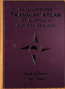
Book, Hugh Ballment and Carl Segnit, "An Illustrated Tramway Atlas of Australia and New Zealand", 2018
... "An Illustrated Tramway Atlas of Australia and New Zealand"...Atlas... Australian tramways...Book - hard cover, 9 sewn sections, full paper bound front covers, 120 pages, gloss paper printed in full colour titled "An Illustrated Tramway Atlas of Australia and New Zealand" with a table of contents by Hugh Ballment and Carl Segnit published by Transit Australia, 2018. ...Ballarat Tramway Museum South Gardens Reserve Wendouree Parade Ballarat Ballarat goldfields Yields information about the extent and cities that had street tramway systems in Australia and New Zealand and in particular Ballarat. Trams tramways Atlas Australian tramways Ballarat Maps Geelong Bendigo Book - hard cover, 9 sewn sections, full paper bound front covers, 120 pages, gloss paper printed in full colour titled "An Illustrated Tramway Atlas of Australia and New Zealand" with a table of contents by Hugh Ballment and Carl Segnit published by Transit Australia, 2018. ...Yields information about the extent and cities that had street tramway systems in Australia and New Zealand and in particular Ballarat.Book - hard cover, 9 sewn sections, full paper bound front covers, 120 pages, gloss paper printed in full colour titled "An Illustrated Tramway Atlas of Australia and New Zealand" with a table of contents by Hugh Ballment and Carl Segnit published by Transit Australia, 2018. Has a preface and acknowledgements, lists 23 Australian and 9 New Zealand cities that had public street tramway systems. Gives maps of the Tramway Museums at the time, trams on public displays and tramway museums that have closed. The Map for the Ballarat Tramway Museum line in Wendouree Parade is not correctly shown.trams, tramways, atlas, australian tramways, ballarat, maps, geelong, bendigo -
 Melbourne Tram Museum
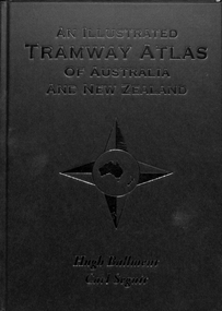
Book, Hugh Ballment, Carl Segnit, "An Illustrated Tramway Atlas of Australia and New Zealand", 2018
... "An Illustrated Tramway Atlas of Australia and New Zealand"...Atlas... Australian tramways...Book - hard cover, 9 sewn sections, full paper bound front covers, 120 pages, gloss paper printed in full colour titled "An Illustrated Tramway Atlas of Australia and New Zealand" with a table of contents by Hugh Ballment and Carl Segnit published by Transit Australia, 2018. ...Melbourne Tram Museum 8 Wallen Road Hawthorn melbourne Trams tramways Atlas Australian tramways Maps Commonwealth Engineering Melbourne VR Cable Trams Depots Book - hard cover, 9 sewn sections, full paper bound front covers, 120 pages, gloss paper printed in full colour titled "An Illustrated Tramway Atlas of Australia and New Zealand" with a table of contents by Hugh Ballment and Carl Segnit published by Transit Australia, 2018. ...Book - hard cover, 9 sewn sections, full paper bound front covers, 120 pages, gloss paper printed in full colour titled "An Illustrated Tramway Atlas of Australia and New Zealand" with a table of contents by Hugh Ballment and Carl Segnit published by Transit Australia, 2018. Has a preface and acknowledgements, lists 23 Australian and 9 New Zealand cities that had public street tramway systems. Gives maps of the Tramway Museums at the time, trams on public displays and tramway museums that have closed. Includes cable trams, some horse trams, VR, Doncaster, Commonwealth Engineering test facility at Dandenong and depot layouts.trams, tramways, atlas, australian tramways, maps, commonwealth engineering, melbourne, vr, cable trams, depots -
 Ballarat Heritage Services
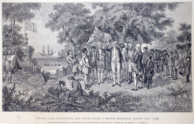
Work on paper - Image, Captain Cook Proclaiming New South Wales and British Possession, Botany Bay, 1770
... First Published in Picturesque Atlas of Australia....Ballarat Heritage Services PO Box 2209 Bakery Hill Post Office goldfields First Published in Picturesque Atlas of Australia. captain cook james cook botany bay endeavour Line drawing of Captain James Cook landing at Botany Bay, New South Wales. ...First Published in Picturesque Atlas of Australia.Line drawing of Captain James Cook landing at Botany Bay, New South Wales.captain cook, james cook, botany bay, endeavour -
 Ballarat Heritage Services
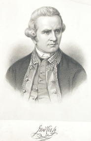
Image, Captain James Cook
... First Published in Picturesque Atlas of Australia....Ballarat Heritage Services PO Box 2209 Bakery Hill Post Office goldfields First Published in Picturesque Atlas of Australia. captain cook james cook botany bay endeavour explorer Line drawing of Captain James Cook. ...First Published in Picturesque Atlas of Australia.Line drawing of Captain James Cook.captain cook, james cook, botany bay, endeavour, explorer -
 Ballarat Heritage Services
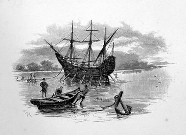
Image, Anchored Ship
... First Published in Picturesque Atlas of Australia....Ballarat Heritage Services PO Box 2209 Bakery Hill Post Office goldfields First Published in Picturesque Atlas of Australia. ship exploration immigration Line drawing of a ship anchored on the coast. ...First Published in Picturesque Atlas of Australia.Line drawing of a ship anchored on the coast.ship, exploration, immigration -
 Ballarat Heritage Services
Image, Lord Carrington, c1886
... First Published in Picturesque Atlas of Australia. ...Ballarat Heritage Services PO Box 2209 Bakery Hill Post Office goldfields First Published in Picturesque Atlas of Australia. portrait lord carrington Line drawing of Lord Carrington. ...First Published in Picturesque Atlas of Australia. Line drawing of Lord Carrington. portrait, lord carrington -
 Stawell Historical Society Inc
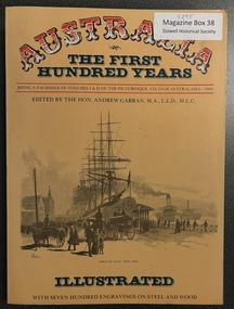
Book, Paul Hamlyn Pty, Ltd, Australia The First Hundred Years, 17.05.2021
... Facsimile of Picturesque Atlas of Australia 1888. Bicentenary of Australia Publication...Facsimile of Picturesque Atlas of Australia 1888. Bicentenary of Australia Publication Illustrated History First Centuary of European Settlement - Inside Front cover. ...Facsimile of Picturesque Atlas of Australia 1888. Bicentenary of Australia PublicationEditor: The Hon. Andrew Gartan M.A., L.L.D., M.L.C. A4 Mustard Cover Book Victoria P 151-254, 255-312. Stawell Lithograph P 275. Information p 277 - 278First Centuary of European Settlement - Inside Front cover. Berthing at Semi Circular Quay Sydney - end of Lithograph engravings.illustrated history -
Lakes Entrance Historical Society
Book, Una Smith, Australia The First Hundred Years, 1976
... A facsimile of volumes 1 and 2 of the picturesque atlas of Australia 1888 including short account of Australia as a penal settlement and establishment of separate states Victoria...Lakes Entrance Historical Society 4 Marine Parade Lakes Entrance gippsland Settlement Exploration Australia A facsimile of volumes 1 and 2 of the picturesque atlas of Australia 1888 including short account of Australia as a penal settlement and establishment of separate states Victoria Australia The First Hundred Years Book Una Smith ...A facsimile of volumes 1 and 2 of the picturesque atlas of Australia 1888 including short account of Australia as a penal settlement and establishment of separate states Victoriasettlement, exploration, australia -
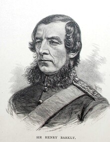 Ballarat Heritage Services
Image, Sir Henry Barkly, Governor of Victoria, c1886
... First Published in Picturesque Atlas of Australia. Artist William Macleod, (1850-1929) had an extensive involvement in the 'Picturesque Atlas of Australasia' publication executing many of the portraits and was chairman of its publishing company. ...Ballarat Heritage Services PO Box 2209 Bakery Hill Post Office goldfields First Published in Picturesque Atlas of Australia. Artist William Macleod, (1850-1929) had an extensive involvement in the 'Picturesque Atlas of Australasia' publication executing many of the portraits and was chairman of its publishing company. ...First Published in Picturesque Atlas of Australia. Artist William Macleod, (1850-1929) had an extensive involvement in the 'Picturesque Atlas of Australasia' publication executing many of the portraits and was chairman of its publishing company. Macleod went onto join the Bulletin full time in 1886. (http://adb.anu.edu.au/biography/macleod-william-7419, accessed 28 March 2019)Line drawing of Henry Barkly.henry barkly, portrait, governor barkly, william macleod -
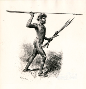 Eltham District Historical Society Inc
Photograph, Sketch of Aboriginal man with spears by W. Macleod
... picturesque atlas of australia...William Macleod (1850-1929) was a contributor to the "Picturesque Atlas of Australia" 1886. Described in "The Daily Telegraph" 21 June 1924 :"Macleod is a preserver of the scenic records of his own time, inasmuch as he has furnished posterity with many view of towns, rivers, and other localities, as they appeared in the years 1886-8. ...Image re-published in "Painters and Pioneers", 1971 pioneers and painters aborigine spear drawing william macleod picturesque atlas of australia aboriginal australian Sketch of Aboriginal man with spears by W. ...This black and white image appears on page 9 "Painters and Pioneers: One hundred years of Eltham and its Shire" by Alan Marshall (1971). (It is incorrectly acknowledged as S.T. Gill in the acknowledgements). It relates to Chapter 1 "The Beginning" and the description of explorer's Joseph Gellibrand journey through the area (and beyond) of the area now known as Eltham and wider Shire of Nillumbik. Gellibrand was accompanied by male aborigines. William Macleod (1850-1929) was a contributor to the "Picturesque Atlas of Australia" 1886. Described in "The Daily Telegraph" 21 June 1924 :"Macleod is a preserver of the scenic records of his own time, inasmuch as he has furnished posterity with many view of towns, rivers, and other localities, as they appeared in the years 1886-8. Among these, he has given us ...a blackfellow throwing a spear...' Image first published 1886. Image re-published in "Painters and Pioneers", 1971 pioneers and painters, aborigine, spear, drawing, william macleod, picturesque atlas of australia, aboriginal australian -
 Sunshine and District Historical Society Incorporated
Pamphlet - Know your neighbourhood, Brimbank City Council Dept of Planning and Development, 2011
... Brochure Know your neighbourhood The Sunshine District|Brochure Know your neighbourhood The Deer Park District|Brochure Know your neighbourhood The St Albans District|Brochure Know your neighbourhood The Keilor District|Brochure Know your neighbourhood The Sydenham District|Data Source Profile & Forcast ID using ABS Census data|Data Source City West Water|Data Source Australian Conservation Consumption Atlas|Data Source Victorian Commission of Gambling regulation|Brochure City West Water Be Water Wise Target 155 in 2018|Brochure City West Water 231 litres per day 2014|Brochure City West Water Be Water Wise Target 155 in 2017|Brochure city West Water Be Water Wise Target 155 in 2016|Albion Neighbourhood Plan 27 Octobe 2012|Explanatory Brochure Albion Neighbourhood Study...Sunshine Brochure Know your neighbourhood The Sunshine District|Brochure Know your neighbourhood The Deer Park District|Brochure Know your neighbourhood The St Albans District|Brochure Know your neighbourhood The Keilor District|Brochure Know your neighbourhood The Sydenham District|Data Source Profile & Forcast ID using ABS Census data|Data Source City West Water|Data Source Australian Conservation Consumption Atlas|Data Source Victorian Commission of Gambling regulation|Brochure City West Water Be Water Wise Target 155 in 2018|Brochure City West Water 231 litres per day 2014|Brochure City West Water Be Water Wise Target 155 in 2017|Brochure city West Water Be Water Wise Target 155 in 2016|Albion Neighbourhood Plan 27 Octobe 2012|Explanatory Brochure Albion Neighbourhood Study Demographic data on the following topics Community population and people Local economy and life long learning Sustainable action and environment 5 four page leaflets Illustrated Each leaflet has a map of the district named Pamphlet Know your neighbourhood Brimbank City Council Dept of Planning and Development Community Planning City of Brimbank. ...Brochure Know your neighbourhood The Sunshine District|Brochure Know your neighbourhood The Deer Park District|Brochure Know your neighbourhood The St Albans District|Brochure Know your neighbourhood The Keilor District|Brochure Know your neighbourhood The Sydenham District|Data Source Profile & Forcast ID using ABS Census data|Data Source City West Water|Data Source Australian Conservation Consumption Atlas|Data Source Victorian Commission of Gambling regulation|Brochure City West Water Be Water Wise Target 155 in 2018|Brochure City West Water 231 litres per day 2014|Brochure City West Water Be Water Wise Target 155 in 2017|Brochure city West Water Be Water Wise Target 155 in 2016|Albion Neighbourhood Plan 27 Octobe 2012|Explanatory Brochure Albion Neighbourhood Studysunshine -
 Warrnambool and District Historical Society Inc.
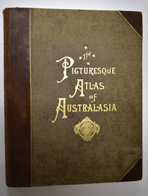
Book - Antiquarian book, Hon. Andrew Garran, Picturesque Atlas of Australasia Volume One, 1886
... Warrnambool History Western District History Australian History Australasian History picturesque atlas of australasia picturesque atlas of australasia volume 1 Contemporary and geographical record of Australasia in the 19th century This is a leather covered book. ...Contemporary and geographical record of Australasia in the 19th centuryThis is a leather covered book. The cover is decorated with gold panels of fruit and gold lettering on the spine and has a plastic cover to protect it. There is gilt edging on the 388 pages. It contains text, sketches, lithographs and some coloured maps and engravings on wood..non-fictionContemporary and geographical record of Australasia in the 19th centurywarrnambool history, western district history, australian history, australasian history, picturesque atlas of australasia, picturesque atlas of australasia volume 1 -
 Warrnambool and District Historical Society Inc.
Book - Antiquarian Book, Hon Andrew Garran, Picturesque Atlas of Australasia Volume Two, 1886
... Australian colonies and New Zealand. The artistic work is of a superior quality. Australasian History Antiquarian Books picturesque atlas of Australasia warrnambool picturesque atlas of australasia volume 2 A contemporary and geographical record of Australasia in the 19th century This is a leather covered book of 801 pages. ...A contemporary and geographical record of Australasia in the 19th centuryThis is a leather covered book of 801 pages. The cover is decorated with gold panels of fruit and has gold lettering on the spine. The pages have gilt edges. It contains text, sketches, lithographs, maps and five loose maps. non-fictionA contemporary and geographical record of Australasia in the 19th centuryaustralasian history, antiquarian books, picturesque atlas of australasia, warrnambool, picturesque atlas of australasia volume 2 -
 Warrnambool and District Historical Society Inc.
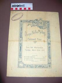
Programme - Program, musical evening, Dame Nellie Melba's Farewell Tour Warrnambool, 1927
... Australian opera singer sang at the Warrnambool Town Hall during her farewell tour. dame nellie melba history of warrnambool lyndoch melba farewell tour Dame Nellie Melba's Farewell Tour This is a cream-coloured sheet of paper folded into two to make four pages. The front cover has a decorative border and blue printing and a Warrnambool & District Historical Society stamp and the back cover has an advertisement. The middle pages contain blue printing. The folds are torn in parts. Dame Nellie Melba's Farewell Tour Warrnambool. Programme Program, musical evening Atlas ...Dame Nellie Melba, born Helen Porter Mitchell (1861-1931), was the first Australian to gain international fame as an opera singer and one of the best-known singers in late Victorian times. She took the name ‘Melba’ from her home town, Melbourne. She sang in Warrnambool on at least two occasions, staying at local homes, including ‘Summer Hill’, belonging to the Murray family and ‘Lyndoch’ as the guest of Florence Lake. In 1927 she sang at the Warrnambool Town Hall with three other assisting artists and this programme records that event. The Warnambool and District Historical Society has an evening bag that was given by Nellie Melba to Miss O’Donnell, a maid at ‘Lyndoch’ at that time. This programme is of considerable significance as it is a memento of the occasion in 1927 when the famous Australian opera singer sang at the Warrnambool Town Hall during her farewell tour. This is a cream-coloured sheet of paper folded into two to make four pages. The front cover has a decorative border and blue printing and a Warrnambool & District Historical Society stamp and the back cover has an advertisement. The middle pages contain blue printing. The folds are torn in parts.Dame Nellie Melba's Farewell Tourdame nellie melba, history of warrnambool, lyndoch, melba farewell tour -
 Bendigo Military Museum
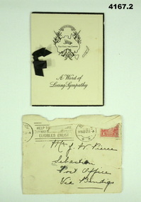
Card - SYMPATHY CARD and ENVELOPE, ATLAS PRESS Marlborough series, Both 1917
... Australia, crossed rifles, wreath, Corolla, inside has a short poem headed “He hath fought the good fight”. Next page a brief sympathy message with hand written entry in ink, a small black ribbon holds the pages together. .2) Yellowish envelope with two circular stamp marks, red 1 penny stamp and addressed in black pen. Envelope is stamped “20 NOV 2017 Card SYMPATHY CARD and ENVELOPE ATLAS ...Items in the collection relating to George Frederick Pierce DCM. Refer Cat No 4136P for his service details, award and death Part of the collection of William (Bill) Thomason, refer Cat No 4136P..1) four page folding card, front cover has a map of Australia, crossed rifles, wreath, Corolla, inside has a short poem headed “He hath fought the good fight”. Next page a brief sympathy message with hand written entry in ink, a small black ribbon holds the pages together. .2) Yellowish envelope with two circular stamp marks, red 1 penny stamp and addressed in black pen. Envelope is stamped “20 NOV 2017.1) front cover,” A world of Sympathy”. Inside in ink from “Hilda C Stephens” .2) on front in black pen, “Mrs J Pierce Sebastian Post Office Via Bendigo”sympathy, cards, military -
 Bendigo Military Museum
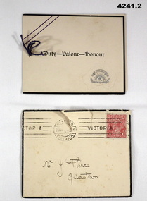
Card - SYMPATHY CARD and ENVELOPE, Atlas Press Marlborough series, printed in Australia, 1917
... Atlas Press Marlborough series, printed in Australia...Australia, central in gold a scroll, Rising Sun, crown and a wreath. Inside has a short poem headed by “Greater love hath no man than this”, next page a brief sympathy message, under in ink an entry by hand. A small string holds the pages together. .2) yellowish envelope with black edging, mail stamps and a 1 penny red stamp. Envelope dated 21 Nov ....... Card SYMPATHY CARD and ENVELOPE Atlas ...Items relate to George Frederick Pierce DCM. Refer Cat No 4136P for his service details, award and death. Part of the collection of William (Bill) Thomason, refer Cat No 4136P for more items..1) Four page folding card, front has an embossed map of Australia, central in gold a scroll, Rising Sun, crown and a wreath. Inside has a short poem headed by “Greater love hath no man than this”, next page a brief sympathy message, under in ink an entry by hand. A small string holds the pages together. .2) yellowish envelope with black edging, mail stamps and a 1 penny red stamp. Envelope dated 21 Nov ....... .1) On the front “ Duty - Valour - Honour”. Inside in ink from, ”Mr and Mrs F Stevens"sympathy, cards, military -
Federation University Historical Collection
Book - Book - Scrapbook, Ballarat College of Advanced Education: Scrapbook of newspaper cutting, Book 16; August 1985 to February 1986
... Australian, The Herald. The cuttings cover the period from 24 August 1985 to 12 February 1986. . employment advertisements application for enrolment outline of courses ballarat college of advanced education bcae vicki nash winter exhibition 72 units for students 'merge but keep it loca' apprentice clowns apartheid may change soon dr john viljoen david addenbrooke dean faculty of arts bcae opens its doors top national art award julie billson alisin mauger senator don chip tax plan fairer base nursing head takes bcae post shirley ogden new and different photovoltaic panel david jirik social atlas of region launched doug wright exhibition student union debate deakin to reopen engineering standards and resources put to the test seminar on occupational health hospitality for tourists high praise from professor geoff bonney wins art prize mural salutes agriculture julie billsonwins national prize new theatre company bcae ahead in phys ed meron mcdonald wins landragin award in graphic design fitness testing scheme piloted in ballarat lloyd crump ceramics nicole mayne honor $1.2m expansion department of nursing department of human and social sciences year of surging progress dr ken hawkins iain reid pints as he pilots ministry causes resentment bcae cries 'unfair' librarian carolyn bray student housing Book with beige cover, front. ...Newspaper cuttings relating to Ballarat College of Advanced Education. These are from various newspapers and include The Age, Ballarat Courier, The Australian, The Herald. The cuttings cover the period from 24 August 1985 to 12 February 1986. . Book with beige cover, front. Spiral bound.employment advertisements, application for enrolment, outline of courses, ballarat college of advanced education, bcae, vicki nash, winter exhibition, 72 units for students, 'merge but keep it loca', apprentice clowns, apartheid may change soon, dr john viljoen, david addenbrooke, dean faculty of arts, bcae opens its doors, top national art award, julie billson, alisin mauger, senator don chip, tax plan fairer, base nursing head takes bcae post, shirley ogden, new and different, photovoltaic panel, david jirik, social atlas of region launched, doug wright exhibition, student union debate, deakin to reopen engineering, standards and resources put to the test, seminar on occupational health, hospitality for tourists, high praise from professor, geoff bonney wins art prize, mural salutes agriculture, julie billsonwins national prize, new theatre company, bcae ahead in phys ed, meron mcdonald wins landragin award in graphic design, fitness testing scheme, piloted in ballarat, lloyd crump ceramics, nicole mayne honor, $1.2m expansion, department of nursing, department of human and social sciences, year of surging progress, dr ken hawkins, iain reid pints as he pilots, ministry causes resentment, bcae cries 'unfair', librarian carolyn bray, student housing -
 Bendigo Historical Society Inc.
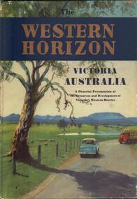
Book - AILEEN AND JOHN ELLISON COLLECTION: THE WESTERN HORIZON
... History House 11 Mackenzie Street Bendigo goldfields BOOKS Atlases Western Victoria The Western Horizon of Victoria Australia. A pictorial presentation of the resources and development of Victoria's western district. ...The Western Horizon of Victoria Australia. A pictorial presentation of the resources and development of Victoria's western district. Australian publicity council, 405 Collins Street, Melbourne. The book has 112 pages. On the inside title a dedication: to Brian with best wishes for your 17th birthday from the Rogers, 22/05/59.books, atlases, western victoria -
 Greensborough Historical Society
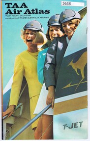
Booklet, TAA Air Atlas, 1972_
... TAA air atlas: your flight souvenir, compliments of Trans-Australia Airlines....TAA Air Atlas Booklet Trans-Australia Airlines ...Souvenir publication, detailing airline routes, services and aircraft. TAA air atlas: your flight souvenir, compliments of Trans-Australia Airlines.16 p., printed in colour, maps, photographs and text.airlines, trans-australia airlines -
 Eltham District Historical Society Inc
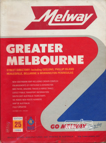
Book, Melway Great Melbourne street directory including Geelong, Phillip Island Healesville, Bellarine & Mornington Peninsulas, 1998
... Cover: (Includes) New Southbank map including Crown Complex, enlargements of Footscray and Kensington, bike paths, walking tracks & horse trails, latest public transport information, South east Australia tours maps, Vic Roads new route numbers, map of Australia streets maps roads melbourne ISSN 03113957 1 atlas (22, 772 p.) : col. maps ; Melway Great Melbourne street directory including Geelong, Phillip Island Healesville, Bellarine & Mornington Peninsulas Book ...25th edition. Coloured detailed maps accessed by a street or location index. Cover: (Includes) New Southbank map including Crown Complex, enlargements of Footscray and Kensington, bike paths, walking tracks & horse trails, latest public transport information, South east Australia tours maps, Vic Roads new route numbers, map of Australia1 atlas (22, 772 p.) : col. maps ; ISSN 03113957streets, maps, roads, melbourne -
 Bendigo Historical Society Inc.
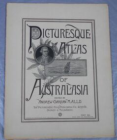
Journal - Picturesque Atlas of Australasia
... Atlas Publishing Company in Wynyard Square, Sydney. The company was established in 1885. Edited by Andrew Garran. For detailed information search the website of the National Library of Australia. ...Volume 42 This last Volume contains a Miscellaneous section at the back with an Editorial Postscript and two maps - Australia and The Solar System. Journal Picturesque Atlas of Australasia ...The Picturesque Atlas of Australasia was released in 42 supplements between 1886 and 1889 and attracted over 50,000 subscribers. Produced by the Picturesque Atlas Publishing Company in Wynyard Square, Sydney. The company was established in 1885. Edited by Andrew Garran. For detailed information search the website of the National Library of Australia. Thirty-three parts. Volume 9 to Volume 42. Volumes 1 - 8 and 28 are missing. Light tan coloured covers have a printed central rectangular double border. The title and publication information and illustrations are printed inside the border. The illustrations included are Captain Cook, a sailing ship and a sprig of wattle. The pages include many black and white illustrations. Volume 16 Separate map of Fiji. This Volume covers Bendigo as one of Victoria's country towns Volume 27 Includes separate Railway, Postal and telegraph map of Queensland. Volume 42 This last Volume contains a Miscellaneous section at the back with an Editorial Postscript and two maps - Australia and The Solar System.australasia, flora and fauna, subscription, history, exploration -
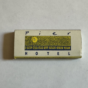 Port Melbourne Historical & Preservation Society
Domestic object - Matchbox, Pier Hotel, Port Melbourne, Atlas Match Australia, 1990s
... Atlas Match Australia...Port Melbourne Historical & Preservation Society Port Melbourne Town Hall 333 Bay Street Port Melbourne melbourne Picked up at the Pier, donated Business and Traders - Hotels Pier Hotel Piranha Lounge Mini matchbox promoting Pier Hotel, blue and yellow; 'Pier Hotel" on front, 'Piranna Lounge' on back. contains 7 blue-headed matches Domestic object Matchbox, Pier Hotel, Port Melbourne Atlas Match Australia ...Picked up at the Pier, donatedMini matchbox promoting Pier Hotel, blue and yellow; 'Pier Hotel" on front, 'Piranna Lounge' on back. contains 7 blue-headed matchesbusiness and traders - hotels, pier hotel, piranha lounge -
Bendigo Historical Society Inc.
Document - ROYAL PRINCESS THEATRE COLLECTION: AUSTRALIAN TOUR OF MARIE HALL, June 10th, 1907
... Atlas Press, Melb. The Royal Princess Theatre, Bendigo. Monday June 10th, 1907. First Australian Tour of Marie Hall. ...The Royal Princess Theatre, Bendigo. Monday June 10th, 1907. First Australian Tour of Marie Hall. Direction J & N Tait. Pianist Lonie Basche. Marie Hall's Recital. Programme:Violin Solo-Concert in E Major. Piano Solos- Etude in E Major, Black Key Study, Valse in A Flat. Violin Solos-Humoreske, Fantasia 'Old England. Piano Solos-Liebestraume, Marche Militaire. Vioin Solos-Ave Maria, The Bee, Zephyr, Hejre Kati. Messrs. J & N Tait have great pleasure in announcing their intention of arranging for the appeaance in Bendigo of 'The Royal Besses O' Th' Barn Band' towards the end of July, and 'Madame Clara Butt, and Mr Kennerley Rumford, together with a Hall Concert Party, about the middle of September. The 'London Daily Telegraph' calls Clara Butt 'The Custodiam of the voice of a century.' Advertising on rear cover.Atlas Press, Melb.program, theatre, the royal princess theatre, bendigo -
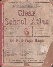 Bendigo Historical Society Inc.
Book - SCHOOL ATLAS, 1880s
... Atlas. 34 page 'CLEAR SCHOOL ATLAS' in colour. Price sixpence. On the map of Australia, page 32, the location of Sandhurst is shown. ...History House 11 Mackenzie Street Bendigo goldfields EDUCATION Bendigo Atlas Bamawm Sandhurst William Collins, Sons & Company, London and Glasgow Atlas. 34 page 'CLEAR SCHOOL ATLAS' in colour. Price sixpence. On the map of Australia, page 32, the location of Sandhurst is shown. ...Atlas. 34 page 'CLEAR SCHOOL ATLAS' in colour. Price sixpence. On the map of Australia, page 32, the location of Sandhurst is shown. Handwritten in ink at top of front cover, 'Fifth Class, Bamawm'William Collins, Sons & Company, London and Glasgoweducation, bendigo, atlas, bamawm, sandhurst