Showing 13 items matching "balfour avenue"
-
 Ringwood and District Historical Society
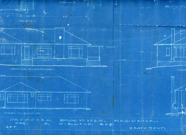
Plan, Architects plan for residence in Balfour Avenue, Heathmont for Stan Wieland , no date
... Architects plan for residence in Balfour Avenue, Heathmont for Stan Wieland , no date...Architect's plan on heavy blue paper for residence at Balfour Avenue , Heathmont...Architect's plan on heavy blue paper for residence at Balfour Avenue , Heathmont Architects plan for residence in Balfour Avenue, Heathmont for Stan Wieland , no date Plan ...Stanley Wieland took over the property called "Fairview" at the corner of Dickasons Road and Canterbury Road, Heathmont after his Father's death in 1945. He married Thelma Wilson in 1930. Their daughter Pat wrote the Wieland History with her husband Don Talbot.Architect's plan on heavy blue paper for residence at Balfour Avenue , Heathmont -
 Ringwood and District Historical Society
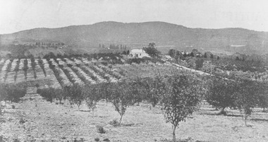
Photograph, View from Canterbury Road/Balfour Avenue area overlooking Martell's orchard, Heathmont, 1929
... View from Canterbury Road/Balfour Avenue area overlooking Martell's orchard, Heathmont, 1929....View from Canterbury Road/Balfour Avenue area overlooking Martell's orchard, Heathmont, 1929. ...Black and white photograph of orchard. House in middle range, mountains in background. Photograph appears to be reproduced from subdivisional brochure. Note inserted in sleeve reads, "It has been pointed out that the mountains are to the east and the view is looking south. This therefore is not a 'straight' photograph. House still exists in Eden Avenue at October, 1996".(3 copies).Typed below photograph, "Panoramic view taken on the estate". "View overlooking Martell's orchard, Heathmont, 1929". Taken from corner Canterbury Rd. and Balfour Ave. looking south. Dandenong Creek just beyond house. Washusen Rd. on right". Written on back of one of the copies, "Heathmont Station Estate 1922". "Station Street, Lisgoold St. Canterbury Rd. Vivienne Cres. Balfour Ave." -
 Sunshine and District Historical Society Incorporated
Administrative record - City of Sunshine - Commissioner Mr Alexander Alex George Gillon Collection 1976 - 1982 - Minutes of the ordinary meeting of council held on 27th March 1979, City of Sunshine, 27th March 1979
... ...Balfour Avenue...Land Transfer Lot 116 Balfour Avenue & Aloysius Street Proposed purchase of land St. ...Albans Road Furlong Road St. Albans Balfour Avenue Aloysius Street Sunshine North Braybrook Land Transfer Lot 116 Balfour Avenue & Aloysius Street Proposed purchase of land St. ...Land Transfer Lot 116 Balfour Avenue & Aloysius Street Proposed purchase of land St. Albans Road corner Furlong Roadst. albans road, furlong road, st. albans, balfour avenue, aloysius street, sunshine north, braybrook -
 Sunshine and District Historical Society Incorporated
Administrative record - City of Sunshine - Commissioner Mr Alexander Alex George Gillon Collection 1976 - 1982 - Notice of ordinary meeting of the council 27th March 1979, City of Sunshine, 21st March 1979
... ...Balfour Avenue...Cafe and Amusement Parlour Derrimut Street Land Transfer Lot 116 Balfour Avenue & Aloysius Street Proposed purchase of land St. ...Albans Road Furlong Road St. Albans Balfour Avenue Aloysius Street Sunshine North Braybrook Cafe and Amusement Parlour Derrimut Street Land Transfer Lot 116 Balfour Avenue & Aloysius Street Proposed purchase of land St. ...Cafe and Amusement Parlour Derrimut Street Land Transfer Lot 116 Balfour Avenue & Aloysius Street Proposed purchase of land St. Albans Road corner Furlong Roadderrimut street, albion, st. albans road, furlong road, st. albans, balfour avenue, aloysius street, sunshine north, braybrook -
 Ringwood and District Historical Society
Pamphlet, Atlas Press Pty. Ltd., Melbourne, Land Sale Brochure, Hill Top Estate, Heathmont, Vic. - circa 1925
... Subdivision plan includes Heathmont Road, Balfour Avenue, Edith Street, Edna Street, and Great Ryrie Street....Ringwood and District Historical Society 125A Warrandyte Road Ringwood North melbourne Subdivision plan includes Heathmont Road, Balfour Avenue, Edith Street, Edna Street, and Great Ryrie Street. ...Twelve page land sale brochure promoting Heathmont and Ringwood area including photographs, subdivision features and local facilities. Subdivision plan includes Heathmont Road, Balfour Avenue, Edith Street, Edna Street, and Great Ryrie Street. -
 Ringwood and District Historical Society
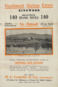
Flyer, Land Sale Brochure, Heathmont Station Estate, Ringwood, Vic. - circa 1925
... Subdivision includes Canterbury Road, Station Street (later Wainui Avenue), Lisgoold Street, Viviani Crescent, and Balfour Avenue. Agent - H.C. Costello & Co., Auctioneer, 128 Queen Street, Melbourne, or Church Street, Middle Brighton. ...Subdivision includes Canterbury Road, Station Street (later Wainui Avenue), Lisgoold Street, Viviani Crescent, and Balfour Avenue. Agent - H.C. Costello & Co., Auctioneer, 128 Queen Street, Melbourne, or Church Street, Middle Brighton. ...Extract of "Herald" 2/2/22: The intention of the Railway Commissioners is to electrify the line to the Gully as soon as convenient, and with greater frequency of service many persons settled, and settling, in the district will be benefited. There is a scheme which may be launched that will allow for an express service of fast trains to the Gully. The commissioners are alive to the necessity for assisting to settle the picturesque districts between Box Hill and Gembrook.Bi-fold advertisement for sale of retail and residential sites, including panoramic and other photographs, map, and summary of subdivision features and local facilities. Subdivision includes Canterbury Road, Station Street (later Wainui Avenue), Lisgoold Street, Viviani Crescent, and Balfour Avenue. Agent - H.C. Costello & Co., Auctioneer, 128 Queen Street, Melbourne, or Church Street, Middle Brighton. Phones: Central 10517 and X1205. -
 Ringwood and District Historical Society
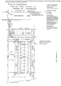
Document - Subdivision Plan, LP23855 Part of Crown Allotment 14B, Parish of Ringwood, County of Mornington, Vol 6687 Fol 394 - 1952
... Map includes Cuthbert Street, Orchard Grove, and Lowen Avenue (formerly part of Balfour Avenue), Heathmont. Other markings include SP25736, LP98835 and LP40209. ...Ringwood and District Historical Society 125A Warrandyte Road Ringwood North melbourne Map includes Cuthbert Street, Orchard Grove, and Lowen Avenue (formerly part of Balfour Avenue), Heathmont. Other markings include SP25736, LP98835 and LP40209. ...LANDATA Land Victoria plan printout circa 2008Map includes Cuthbert Street, Orchard Grove, and Lowen Avenue (formerly part of Balfour Avenue), Heathmont. Other markings include SP25736, LP98835 and LP40209. Accompanying pencil sketch on light cardboard backing includes sales notations on lots 4 to 8 on Sunset Drive and Cuthbert Street and comment - Roads to be formed & E.L&W provided by vendor. -
 Ringwood and District Historical Society
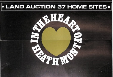
Pamphlet, Land Auction Brochure - Heathmont Hills Estate, Heathmont, Vic
... Subdivision includes Canterbury Road, Cuthbert Street, and Craig Court, off Balfour Avenue, Heathmont. Agent - N.R. Reid & Co Pty Ltd., 173 Coleman Parade, Glen Waverley, (phone) 560 0355 A.H. 28 3185, in conjunction with H.G. ...Subdivision includes Canterbury Road, Cuthbert Street, and Craig Court, off Balfour Avenue, Heathmont. Agent - N.R. Reid & Co Pty Ltd., 173 Coleman Parade, Glen Waverley, (phone) 560 0355 A.H. 28 3185, in conjunction with H.G. ...Multi-fold brochure advertising auction of 37 home sites on Saturday May 6th, (1967?). Brochure includes terms of sale, description of subdivision features and local facilities, with locality map. Subdivision includes Canterbury Road, Cuthbert Street, and Craig Court, off Balfour Avenue, Heathmont. Agent - N.R. Reid & Co Pty Ltd., 173 Coleman Parade, Glen Waverley, (phone) 560 0355 A.H. 28 3185, in conjunction with H.G. McLean Pty Ltd., 166 Canterbury Road, Heathmont, 87 7808 A.H. 842 2708. -
 Ringwood and District Historical Society
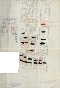
Document, Map showing numbered subdivision allotments with hand-written notations and redactions - 1924
... Also includes hand-drawn allotments on Canterbury Road and Balfour Avenue. Page rubber-stamped by building company A & C Jaworski, Office 2, 23 Ringwood Street, Ringwood 3134, Tel 870-0820, A.H. 870-2062. ...Also includes hand-drawn allotments on Canterbury Road and Balfour Avenue. Page rubber-stamped by building company A & C Jaworski, Office 2, 23 Ringwood Street, Ringwood 3134, Tel 870-0820, A.H. 870-2062. ...Foolscap size page Map by Arnold Wilson & Associates, Engineers & Surveyors, 399 St.Kilda Road, Melbourne, Tel 26-1840 - 1924/4. Subdivision includes Ilford Road, Karen Court, Washusen Road and Dirkala Avenue, Heathmont. Also includes hand-drawn allotments on Canterbury Road and Balfour Avenue. Page rubber-stamped by building company A & C Jaworski, Office 2, 23 Ringwood Street, Ringwood 3134, Tel 870-0820, A.H. 870-2062. -
 Ringwood and District Historical Society
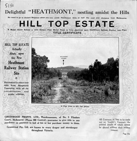
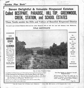
Pamphlet, Land Sale Brochure Titled Eureka Plan Book - Seven Delightful & Valuable Ringwood Estates - circa 1925
... Plan of Hill Top Estate, Ringwood (later Heathmont area), includes Heathmont Railway Station, Heathmont Road, Balfour Avenue, Lilian Street, Edith Street, Edna Street and Great Ryrie Street. ...Plan of Hill Top Estate, Ringwood (later Heathmont area), includes Heathmont Railway Station, Heathmont Road, Balfour Avenue, Lilian Street, Edith Street, Edna Street and Great Ryrie Street. ...Twenty page land sale brochure including photographs, subdivision features and local facilities. Additional flyer with conditions of sale and prices for estate blocks.Seven delightful and valuable Ringwood Estates called Bestpart, Paradise, Hill Top, Greenwood, Creek, Station, and School Estates. These nestle amidst the hills and valleys of beautiful Ringwood district. Also Goodluck Estate at Clarinda. Pamphlet marked as being From Mr. Farmer, No. 5 Flinders Court, Melbourne. Phone 988, 989 Central, or 55 Ringwood after 7 p.m. Plan of Ringwood School Estate includes William Street (later Kendall Street), Greenwood Avenue, Alton Street and Locke Street. Plan of Bestpart Estate, Ringwood, includes Bedford Road, Wilana Street, Greenwood Avenue, Caroline Street, Henry Street and Haig Street. Plan of Ringwood Station Estate includes Pitt Street, Bedford Road, Greenwood Avenue, Station Street, William Street (later Kendall Street, James Street, Wantirna Road, Caroline Street, Henry Street, Ellison Street and Haig Street. Plan of Geenwood Estate, Ringwood, includes Prussian Road (later Geenwood Avenue). Plan of Paradise Estate, Ringwood, includes Canterbury Road, Dandenong Road (Wantirna Road), Luck Street and Paradise Road. Plan of Creek Estate, Ringwood, includes Dandenong Creek, Wantirna Road and Gordon Crescent. Plan of Hill Top Estate, Ringwood (later Heathmont area), includes Heathmont Railway Station, Heathmont Road, Balfour Avenue, Lilian Street, Edith Street, Edna Street and Great Ryrie Street. Plan of Goodluck Estate, Clarinda, includes Talbot Avenue, Good Street, Luck Street, and Centre Road in locality plan between Oakleigh and Clayton Railway Stations. -
 Ringwood and District Historical Society
Document, State School No 4688, Francis Street, Heathmont, 3135, c 1969
... Fleigner since retired and still a Heathmont resident, woe instrumental in obtaining a site for the establishment of the present Heathmont School at the corner of Frances Street and Balfour Avenue. The land was purchased from Mr. ...Fleigner since retired and still a Heathmont resident, woe instrumental in obtaining a site for the establishment of the present Heathmont School at the corner of Frances Street and Balfour Avenue. The land was purchased from Mr. ...Two A4 pages of typed notes on the beginnings of the Heathmont State School. The text is:- STATE SCHOOL No 4698 Frances Street Heathmont, 3135 HISTORY School classes at Heathmont commenced in the original Methodist Church building in Canterbury Road in 1952 with Mr A.J. McKinlay as Head Teacher in charge of a school of 80 pupils. Shortly afterwards both a Parents and Citizens Association and the first School Committee were formed. Mr J.B. Harper was appointed as president of the Association and Mr H. Walker was elected as chairmen of the Committee, while Mr T. Jago acted as secretary to both bodies. Later in that same year the district Inspector, Mr H. Fleigner since retired and still a Heathmont resident, woe instrumental in obtaining a site for the establishment of the present Heathmont School at the corner of Frances Street and Balfour Avenue. The land was purchased from Mr. Handasyde, an orchardist of Wantirna South. In March 1963 a Bristol prefabricated aluminium building comprising four classrooms and an office was occupied. On April 21st, 1953 the school was opened officially by the Minister for Education, the Hon. A.E. Shepherd MLA. By December of that year the attendance had increased to 191 pupils, Mr N. Gillham was Head Teacher at the time. In February 1955 Mr. K. Gerraty succeeded Mr Gillham and by 1957 attendance had risen to 326 pupils necessitating the provision of additional light timber construction classrooms. Meanwhile the subdivision of large areas of local orchard land into housing estates with its resulting rapidly increasing population presented a persistent school accommodation problem that was met temporarily by the hiring of district church halls to accommodate a steadily rising attendance. Fortunately the tradition of voluntarily contributing to school funds and voluntarily providing labour initiated by the original parent bodies in 1952 was maintained. Then Mr V. Milligan commenced as Head Teacher in 1959, much of the steeply contoured playground area had been terraced, a football oval formed and the basketball court and assembly areas were sealed. These improvements were finally completed largely due to the enthusiasm, vigor and work effected by the School Committee under the chairmanship of Ringwood Councillor Mr JM McRae, as is borne out by the following report by Mr R.J. Chapman, District Inspector in 1961. "The local support by parents given to the Head Teacher and his staff is exceptional and I express my appreciation of their outstanding service." Mr Milligan's contribution to progress, however, lay equally in the internal educational development, particularly with regard to the teaching of reading. A course in the mechanics of speed reading, involving the use of the tachistoscope reading rate controllers and programmed comprehension sets was introduced and a start was made in the building up of a library of literature and reference books. As a result the Education Department appointed a Teacher-librarian to ensure continuity and further progress with this Reading scheme. A feature of Heathmont School is the splendid modern Art/Craft room opened while Mr L. Sebire was head teacher in 1966. This building and courtyard, linked to the original building by a covered way was designed by Mr Salvatore who acted as honorary architect, and was completed by Mr John F. Swan at a cost of �10,000 of which 52% was provided by a School Committee Co-operative loan and 42% by Departmental special grant. Materials used were white sandstone brick and oregon pine. The building bears the name of Councillor J.M. McRae Art Centre as a tribute to the man who did so much to enable its construction. An Art/Craft specialist teacher is provided by the Education Department. As attendance continued to increase to 520 children in 1969, additional accommodation became an urgent necessity. Following negotiations conducted by Mr A. Lethbridge School Committee President, Mr JJ Egan, former Principal and the present Principal, Mr A.S. Don the Education Department Assisted by a second Committee Co-operative loan, purchased the adjacent Baptist Church property thus providing much needed extra accommodation and playground area The newly acquired building is at present in use as two temporary classrooms, but will subsequent be used as a utility rope. A smaller room has been converted to a canteen operated daily by the Parents and Citizens Association, thus providing both a service to the pupils and a source of income. +Additional Keywords: McKinlay, Mr.A G Harper, Mr J.B Walker,Mr.H Fleigner, Mr.H Handasyde, Mr. G Shepherd, Hon. A.E. MLA Gillham, Mr.K Garraty, Mr.K Milligan, Mr.V McRae, Mr. J.M. Chapman,Mr.R.J. Sebire,Mr.L Salvatore,Mr. Swann,Mr.John F. Lethbridge, mr.A Egan,Mr.J.J. Don,Mr.A.S. -
 Kew Historical Society Inc
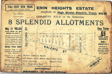
Plan - Subdivision Plan, Erin Heights Estate, East kew, 1917
... Balfour Road was to be only a temporary name as the street is currently called Windella Avenue. ...Balfour Road was to be only a temporary name as the street is currently called Windella Avenue. ...Pru Sanderson, in her groundbreaking ‘City of Kew Urban Conservation Study : Volume 2 - Development History’ (1988), summarised the periods of urban development and subdivisions of land in Kew. The periods that she identified included 1845-1880, 1880-1893, 1893-1921, 1921-1933, 1933-1943, and Post-War Development. These periods were selected as they represented periods of rapid growth or decline in urban development. An obvious starting point for Sanderson’s groupings involved population growth and the associated economic cycles. These cycles also highlighted urban expansion onto land that was predominantly rural, although in other cases it represented the decline and breakup of large estates. A number of the plans in the Kew Historical Society’s collection can also be found in other collections, such as those of the State Library of Victoria and the Boroondara Library Service. A number are however unique to the collection.The Kew Historical Society collection includes almost 100 subdivision plans pertaining to suburbs of the City of Melbourne. Most of these are of Kew, Kew East or Studley Park, although a smaller number are plans of Camberwell, Deepdene, Balwyn and Hawthorn. It is believed that the majority of the plans were gifted to the Society by persons connected with the real estate firm - J. R. Mathers and McMillan, 136 Cotham Road, Kew. The Plans in the collection are rarely in pristine form, being working plans on which the agent would write notes and record lots sold and the prices of these. The subdivision plans are historically significant examples of the growth of urban Melbourne from the beginning of the 20th Century up until the 1980s. A number of the plans are double-sided and often include a photograph on the reverse. A number of the latter are by noted photographers such as J.E. Barnes.The Erin Heights Estate in Kew included just seven lots in in Valerie Street. These were all that remained of this wartime subdivision, the other 11 allotments on Balfour and Belford Roads having already been sold. Balfour Road was to be only a temporary name as the street is currently called Windella Avenue. Now, the parkland opposite the subdivision is the reserve created from the route of the Outer Circle Railway. This Railway reached Kew East in 1925, but had been planned as far back as 1873. The development focuses on the benefits of living in Kew: being at the highest of Kew’s ‘suburbs’; being a good residential area; its rapid growth; and the proximity of the Kew East tram in High Street. In 1917, the electric tramline only extended to a terminus at the Harp of Erin hotel. The terminus is clearly represented on the plan.subdivision plans - east kew, erin heights estate -
 Kew Historical Society Inc
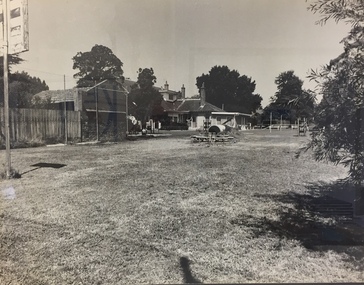
Photograph - 'Carronbank', Marshall Avenue, 1980s
... Carronbank (demolished) in Marshall Avenue, Kew was once the home of the Rev Graham Henty Balfour. It had extensive grounds, including a tennis court at the rear of the property. ...Kew Historical Society Inc Kew Court House 188 High Street Kew melbourne Carronbank (demolished) in Marshall Avenue, Kew was once the home of the Rev Graham Henty Balfour. It had extensive grounds, including a tennis court at the rear of the property. ...Carronbank (demolished) in Marshall Avenue, Kew was once the home of the Rev Graham Henty Balfour. It had extensive grounds, including a tennis court at the rear of the property. It remained a private residence until c.1960. The Department of Education purchased Carronbank as a school for partially sighted children, opening in February 1961 as State School No 4483. During the period 1961 to c.1980, the building housed a number of services. From 1969 to 1974, it was the site of Carronbank State School, later renamed Carronbank School for Deaf-Blind Children. In 1973, the Department established the Visiting Teacher Service for the Visually Impaired at the site. Its aim was to support teachers working in Victorian Government, Catholic and Independent Schools. From 1983 the school operated as Statewide Resource Centre for Visiting Teachers of the Vision Impaired. In 1988, the amalgamation of Princess Elizabeth Junior School for Deaf Children, the Monnington Centre and Carronbank School for Deaf Blind Students allowed the Victorian Government to sell each of the sites. Monnington [Adeney Avenue, Kew] reverted to private ownership, while Glendonald and Carronbank in Marshall Avenue were demolished and subdivided.The donor, Mr Murray Osler, was Principal of the Monnington Special Education Centre in Adeney Avenue (Kew) from 1976. This photo, and an accompanying drawing of 'Monnington' are important primary resources for the delivery of education to and for deaf-blind children in Victoria.The photograph, framed under perspex, shows the tennis court of Carronbank which had been converted into a play area for the students of the school. The flat roofed building may have been a toilet block, added for the school. The garage brick wall belongs to No 11. Grass is growing on the original asphalt court and there is equipment and tunnels for play. When sold the property was divided into three separate building blocks.carronbank -- marshall avenue -- kew (vic.), schools -- kew (vic.), carronbank