Showing 116 items matching "beechworth goldfield"
-
 The Beechworth Burke Museum
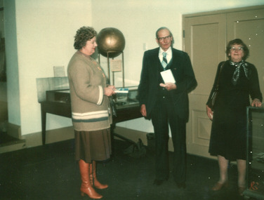
Photograph, Border Morning Mail newspaper, 14/5/2979
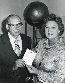
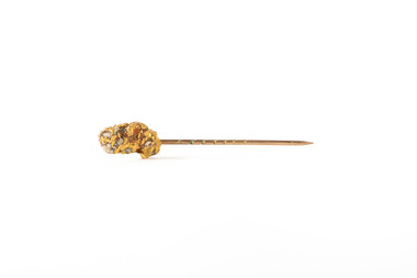
... ...Beechworth goldfield...The tie pin artefact being donated in this photo is entered into the Victorian Collections database as follows: 'This nugget was found on the Beechworth Goldfield in the late 1800s by Mr Fred McIntosh (Alan & Edward Dunlop's Uncle by marriage, husband of Elizabeth (Bessie) Dunlop), who had made it into a tie pin and presented it to the Dunlop family'. ...It is of social significance as it depicts two well-known and respected Beechworth locals handling a key artefact of significance to the Beechworth Goldfields, and therefore Beechworth local history. ...This photograph is recorded as depicting the presentation by Mr Alan Dunlop to Cr Val Mason, Shire President, of a 2.86-gram solid gold nugget found in the area more than 100 years ago, at the Burke Museum. The gold is reported as attached to a small amount of milk quartz mounted onto a tie pin. The photo and an article about the donation appeared in the Border Morning Mail on Friday 14th May, 1979. Alan Dunlop, pictured, was Sir Edward 'Weary' Dunlop's older brother. The tie pin artefact being donated in this photo is entered into the Victorian Collections database as follows: 'This nugget was found on the Beechworth Goldfield in the late 1800s by Mr Fred McIntosh (Alan & Edward Dunlop's Uncle by marriage, husband of Elizabeth (Bessie) Dunlop), who had made it into a tie pin and presented it to the Dunlop family'. Furthermore, Val Mason was the first female president of the former Beechworth Shire for two terms and a councillor for nine years. This photograph is of historic significance as it depicts known individuals who have connections to key Australian figures. Alan Dunlop is the brother of famous war doctor Edward 'Weary' Dunlop, and both men are Beechworth locals. The object Alan holds is a tie pin made from gold found by the Dunlops' uncle. It's also significant as it documents visually the origin of the tie pin artefact in the Burke Museum collection, via donation by Alan Dunlop. In addition, it depicts Val Mason, the first female president of the former Beechworth Shire for two terms and a councillor for nine years. It is of social significance as it depicts two well-known and respected Beechworth locals handling a key artefact of significance to the Beechworth Goldfields, and therefore Beechworth local history. It also shows the Burke Museum in 1979, providing research potential for those interested in the history of the development of the museum's collection.Black and white, rectangular photograph printed on paper.Obverse: (lllegible) Reverse: A02653weary dunlop, gold, beechworth, val mason, tie pin, jewellery, goldfield, beechworth goldfield, fred mcintosh, bessie dunlop, elizabeth dunlop, dunlop, border morning mail, victorian collections, donation, burke museum -
 The Beechworth Burke Museum
Audio - Oral History, Jennifer Williams, Mr Horace Monshing, 6th July 2000
... ...Beechworth goldfield...Peter Monshing Peter Munshing Horace Monshing Monshing Munshing Beechworth Chinese community Chinese Immigration Chinese community chinese miners Immigration gold rush immigration Beechworth goldfield Marketing and promoting agricultural products market garden garden Racism discrimination Oral History Jennifer Williams Myrtleford Eurobin Beechworth Primary School Beechworth State School. ...Horace Monshing was born in Beechworth in 1935. In this oral history, he relates his understanding of the life of his Grandfather, Peter Monshing (Munshing), as a Chinese immigrant to Australia in the mid-nineteenth century, as well as his life as the last descendent of Chinese goldminers to live in Beechworth. While Peter, who was originally from Hong Kong, was not a particularly successful goldminer, he was a very talented gardener, and made his living growing a market garden and selling the produce. He died in 1947 in his nineties, in the same year that Horace and his parents moved to Myrtleford. Horace relates the discrimination he faced as a child based on his grandfather’s ethnicity, as well as how his grandmother, mother and wife have all faced discrimination for marrying into a family with a Chinese name. This oral history recording was part of a project conducted by Jennifer Williams in the year 2000 to capture the everyday life and struggles in Beechworth during the twentieth century. This project involved recording seventy oral histories on cassette tapes of local Beechworth residents which were then published in a book titled: Listen to what they say: voices of twentieth century Beechworth. These cassette tapes were digitised in July 2021 with funds made available by the Friends of the Burke. Mr Horace Monshing’s account of his life in Beechworth and Myrtleford and the local area during the 20th century, as well as his understanding of his grandfather, Peter Monshing’s life as a Chinese immigrant in the mid-nineteenth century, is historically and socially significant to the cultural heritage of the region, especially as it relates to Chinese settlers in the region. He details the discrimination he and his family have faced as the result of being related to a Chinese immigrant, as well as describing his life in general. This oral history account is socially and historically significant as it is a part of a broader collection of interviews conducted by Jennifer Williams which were published in the book 'Listen to what they say: voices of twentieth-century Beechworth.' While the township of Beechworth is known for its history as a gold rush town, these accounts provide a unique insight into the day-to-day life of the town's residents during the 20th century, many of which will have now been lost if they had not been preserved. This is a digital copy of a recording that was originally captured on a cassette tape. The cassette tape is black with a horizontal white strip and is currently stored in a clear flat plastic rectangular container. It holds up 45 minutes of recordings on each sideMr Horace Monshing / peter monshing, peter munshing, horace monshing, monshing, munshing, beechworth chinese community, chinese immigration, chinese community, chinese miners, immigration, gold rush immigration, beechworth goldfield, marketing and promoting agricultural products, market garden, garden, racism, discrimination, oral history, jennifer williams, myrtleford, eurobin, beechworth primary school, beechworth state school., school, listen to what they say: voices of twentieth century beechworth, listen to what they say, burke museum -
 The Beechworth Burke Museum
Photograph
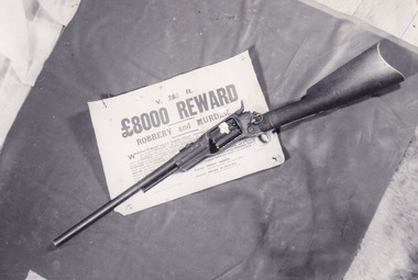
... ...beechworth goldfield...It could be beneficial to undertake a close study of the use history and reception of these artefacts within the museum context. kelly album ned kelly kelly gang joe byrne rewards outlaw criminals bushrangers colt police firearm beechworth reward felon's apprehension act 1878 1880 glenrowan colt revolver revolving rifle 8000 pound reward jerilderie euroa beechworth goldfield Reverse: 10268 / Joe Byrne's / Rifle Black and white rectangular reproduced photograph printed on matte photographic paper Photograph Photograph ...In this image a Colt 1855 Revolving Rifle is placed upon a sign detailing an £8,000 reward for robbery and murder. Writing on the rear of the photograph identifies the rifle as having belonged to Joe Byrne. In colonial Victoria, the Colt brand firearm was highly popular. They began their popularity in the goldfields of the early 1850s. Individuals, particularly those coming to Victoria with prior experience in the goldfield, brought with them a means of self-defence because of the prevalence of assault and robbery on the goldfields. In the 1860s, the Colt firearm became popular among the Victorian Police force. It was decided in June 1864 by Chief Commissioner of Police, Frederick Standish that the Colt revolvers were far more practical, being of simpler construction and therefore, more easily cleaned and less dangerous than the revolvers used prior to this: the Adams and Kerr firearms. The Colt revolver remained in use in regional districts of Victoria as late as the early 1880 when they were used at the Kelly siege at Glenrowan. The £8,000 reward was issued in 1879 after the Kelly Gang committed numerous bank robberies at Euroa and Jerilderie. In the year prior, the Kelly Gang murdered three policemen at Stringybark Creek. This resulted in the creation of the “Felon’s Apprehension Act 1878” which enabled an individual, whether a part of the Police force or civilian, to shoot a declared outlaw on sight. After the bank robberies, the Police force of NSW and Victoria increased the existing reward to this £8,000 amount.This photograph is significant for what it can potentially reveal about the Kelly Gang and firearms made in this period. The rifle in the image is a Colt Revolving Rifle which was known to have been used by the Victorian Police force from the early 1850s to the late 1880s. It is also known that the Kelly Gang stole police rifles which they used to practise with and so the identification of the rifle as having belonged to Joe Byrne is of significant importance to researchers studying the firearms of the Kelly Gang. More research is needed to solidify the connection of this particular weapon to Byrne other than the handwritten note on the back of the photograph. The Burke Museum Beechworth is home to a significant collection of photographs connected to Ned Kelly and the Kelly Gang. Photographs like this one are valuable for what they can potentially reveal about the Kelly Gang and the Police force during this period. Alongside the study of the other images, photographs from this collection have the ability to further expand current knowledge on this period of Australian history. There is also the capability to provide an analysis of how these firearms and Kelly memorabilia have been received in the past. It could be beneficial to undertake a close study of the use history and reception of these artefacts within the museum context.Black and white rectangular reproduced photograph printed on matte photographic paperReverse: 10268 / Joe Byrne's / Riflekelly album, ned kelly, kelly gang, joe byrne, rewards, outlaw, criminals, bushrangers, colt, police, firearm, beechworth, reward, felon's apprehension act 1878, 1880, glenrowan, colt revolver, revolving rifle, 8000 pound reward, jerilderie, euroa, beechworth goldfield -
 The Beechworth Burke Museum
Photograph, c1900
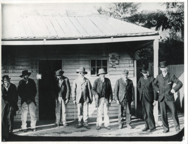
... Beechworth...Ovens Goldfield...Beechworth Chinese Camp Beechworth Chinese Camps 1900s Beechworth Ovens Goldfield Chinese mining community Beechworth Presbyterian Church Reverse: Chinese / BMM2676 / 84-79-1 / 1998.00059 / 'UNITED SHIRE OF BEECHWORTH / SHIRE SECRETARY' Black and white rectangular photograph (copy) on matte photographic paper unmounted Photograph Photograph ...This black and white photograph taken c1900 at a camp in Beechworth, depicts the last six survivors of the Beechworth Chinese mining community. The two men standing on the far right are believed to be local Beechworth men. The man second-from-right is believed to be George Young, a Chinese Presbyterian catechist whose task was to fulfil the Church's remit to evangelise the Chinese population. Beechworth became home to one of the largest Chinese communities in Australia after the 1857 Buckland Riots pushed Chinese miners from their claims and they were forced to relocate their camps. Under the Protectorate system, the Chinese were required to live in camps on the outskirts of town and were subject to many additional controls and regulations. Chinese miners continued to form a large part of the Beechworth population, and surrounds, until gold ran out at the turn of the century.This photograph is historically significant for its association with the development of Victoria through the discovery of gold and the first wave of free Chinese immigration to Australia as part of the 1850s gold rush. This photograph is also of social significance for its association with the history of the Chinese community in Beechworth, and the adversity faced by Chinese immigrants during the gold rush as part of a system of Chinese protectorates and segregated camps enforced by the Victorian Government in response to the hostility and violence directed at the Chinese during this period. Black and white rectangular photograph (copy) on matte photographic paper unmountedReverse: Chinese / BMM2676 / 84-79-1 / 1998.00059 / 'UNITED SHIRE OF BEECHWORTH / SHIRE SECRETARY'beechworth, chinese camp, beechworth chinese camps, 1900s beechworth, ovens goldfield, chinese mining community, beechworth presbyterian church -
 Tatura Irrigation & Wartime Camps Museum
Book, Victorian Historical Journal Volume 87 Number 2 December 2016
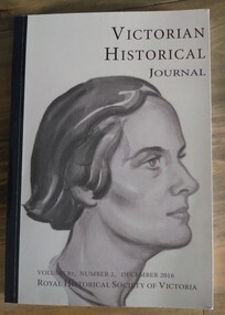
... Articles on various topics, including Melbourne Labour Market, Storm Centre of Asia, Beechworth Goldfields, Wirrengren-Kulkyne Pathway, Messrs Gellibrand and Hesse. 336 pages....Tatura Irrigation & Wartime Camps Museum 49 Hogan Street Tatura the-murray Articles on various topics, including Melbourne Labour Market, Storm Centre of Asia, Beechworth Goldfields, Wirrengren-Kulkyne Pathway, Messrs Gellibrand and Hesse. 336 pages. melbourne labour market storm centre of asia beechworth goldfields wirrengren-kulkyne pathway mr gellibrand mr hesse Soft cover book, front cover has title in dark grey on cream background. ...Articles on various topics, including Melbourne Labour Market, Storm Centre of Asia, Beechworth Goldfields, Wirrengren-Kulkyne Pathway, Messrs Gellibrand and Hesse. 336 pages.Soft cover book, front cover has title in dark grey on cream background. Picture of a lady looking to the right. Volume, number and date and Royal Historical Society of Victoria at the bottom. Spine is black with white writing. Back is brown with Royal Historical Society logo and address.melbourne labour market, storm centre of asia, beechworth goldfields, wirrengren-kulkyne pathway, mr gellibrand, mr hesse -
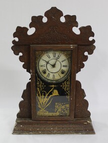
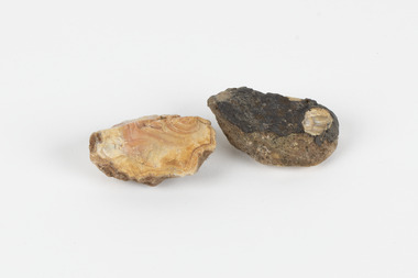
 The Beechworth Burke Museum
Domestic object - Tie Pin
... beechworth...burke museum...tie pin...pin...gold rush...goldfield...This nugget was found on the Beechworth Goldfield in the late 1800's by Mr Fred McIntosh (Alan & Edward Dunlop's Uncle (father James' brother-in-law) by marriage, husband of Elizabeth (Bessie) Dunlop), who had made it into a tie pin and presented it to the Dunlop family. ...This nugget was found on the Beechworth Goldfield in the late 1800's by Mr Fred McIntosh (Alan & Edward Dunlop's Uncle (father James' brother-in-law) by marriage, husband of Elizabeth (Bessie) Dunlop), who had made it into a tie pin and presented it to the Dunlop family. gold nugget beechworth burke museum tie pin pin gold rush goldfield A small nugget of gold made into a tie pin. ...This nugget was found on the Beechworth Goldfield in the late 1800's by Mr Fred McIntosh (Alan & Edward Dunlop's Uncle (father James' brother-in-law) by marriage, husband of Elizabeth (Bessie) Dunlop), who had made it into a tie pin and presented it to the Dunlop family. A small nugget of gold made into a tie pin. The nugget is attached to a small amount of milky quartz stone and mounted on a tie pin.gold, nugget, beechworth, burke museum, tie pin, pin, gold rush, goldfield -
 The Beechworth Burke Museum
Photograph, 14/05/1979
... Beechworth...Burke Museum...goldrush...goldfield...The tie pin artefact being donated in this photograph is entered into the Victorian Collections, and records that the nugget was found in the Beechworth Goldfields by Mr Fred McIntosh, in the last 1800s. ...The tie pin artefact being donated in this photograph is entered into the Victorian Collections, and records that the nugget was found in the Beechworth Goldfields by Mr Fred McIntosh, in the last 1800s. ...Taken on 14 May 1979, this photo depicts Mr Alan J. Dunlop and his wife presenting a 2.86-gram solid gold nugget found in the Beechworth area more than 100 years ago, to the Shire President, Councillor Mrs Valerie Mason. The gold is reported as attached to a small amount of milk quartz mounted onto a tie pin, and was donated to the Burke Museum by the Dunlop family. Alan Dunlop, pictured, was Sir Edward 'Weary' Dunlop's older brother. The tie pin artefact being donated in this photograph is entered into the Victorian Collections, and records that the nugget was found in the Beechworth Goldfields by Mr Fred McIntosh, in the last 1800s. Fred McIntosh, the husband of Elizabeth (Bessie) Dunlop (the sister of Alan & Edward's father, John) had the nugget made into tie pin and presented it to the Dunlop Family. Furthermore, Valerie 'Val' Mason was the first female president of the former Beechworth Shire for two terms and a councillor for nine years. This photograph is of historic significance as it depicts known individuals who have connections to key Australian figures. Alan Dunlop is the brother of famous war doctor Edward 'Weary' Dunlop, and both men are Beechworth locals. The object Alan holds is a tie pin made from gold found by the Dunlops' uncle, and the provenance of the item – from goldfield to family collection to museum collection – provides a recent context with which to interpret the significance of gold-mining on present and future generations, as well as strong research potential on minerals known to be sourced in the area. In conjunction with other photographs in the collection, this photograph visually documents the donation and acquisition of the tie pin artefact into the Burke Museum Collection. In addition, it depicts Valerie ‘Val’ Mason, in her role as the president of the former Beechworth Shire. Val was the first female in this role, which she held for two terms, and was a councillor in the Shire for nine years. This photograph is of social significance as it depicts two well-known and respected Beechworth locals handling a key artefact of significance to the Beechworth Goldfields. It also shows the Burke Museum in 1979, providing research potential for those interested in the history of the development of the museum's collection. Colour rectangular photograph printed on matte photographic paper.Reverse: Polacolor (Registered Trademark symbol) Type 108 / LR / Mrs Valerie Mason / Mr Dunlop (Weary's brother) / Mrs Vivian Payne (erased) / 14-5-1979 A.J. Dunlop & wife with Cr. Mason /L85052P gold, nugget, tie pin, pin, beechworth, burke museum, goldrush, goldfield, dunlop, edward dunlop, weary dunlop, alan dunlop, valerie mason, fred mcintosh, gold mining, donation, museum, collection, president, councillor, shire, female -
 The Beechworth Burke Museum
Photograph, c.1930s
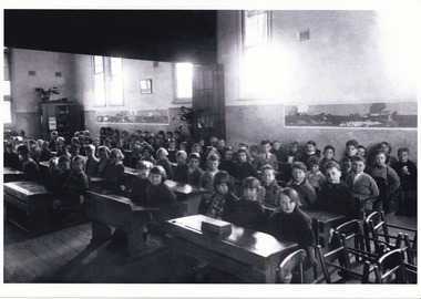
... The Beechworth Primary School itself is a reflection of Beechworth's growth from a goldfields town in the 1850s to an administrative centre of northeast Victoria by the 1920s, supported by the presence of courts, hospital, prison and asylums. ...The Beechworth Primary School itself is a reflection of Beechworth's growth from a goldfields town in the 1850s to an administrative centre of northeast Victoria by the 1920s, supported by the presence of courts, hospital, prison and asylums. ...This photograph depicts a large and crowded classroom at Beechworth Primary School, taken sometime in the 1930s. By that time, primary education in Victoria for children aged 6 to 15 years had been free, secular and compulsory since the Education Act of 1872. Among the students is the owner of the photograph, Jack Schofield. The Beechworth Primary School itself is a reflection of Beechworth's growth from a goldfields town in the 1850s to an administrative centre of northeast Victoria by the 1920s, supported by the presence of courts, hospital, prison and asylums. This photograph has historical significance as it illustrates a typical classroom in 1930s Beechworth. It gives a glimpse of classroom arrangements and student life during this period and also reflects the emphasis placed on public education in regional Victoria. Black and white rectangular photograph printed on matte photographic paper.Reverse: 7699.1beechworth primary school, beechworth elementary school, school, students, education, 1930s classroom -
 Wodonga & District Historical Society Inc
Functional object - 'Sessions' Cottage Clock - early 20th century
... After docking in Melbourne Franz headed for the goldfields in Beechworth, but didn't strike gold. He returned to his trade and opened a boot shop in Wodonga, which burnt to the ground the day before the opening. ...After docking in Melbourne Franz headed for the goldfields in Beechworth, but didn't strike gold. He returned to his trade and opened a boot shop in Wodonga, which burnt to the ground the day before the opening. ...This clock was produced by the American Sessions Clock Company. The company was formed in 1903, after William E. Sessions and his nephew Albert L. Sessions bought out the failing clock company of E.N.Welch Manufacturing. The clock belonged to local Wodonga bootmaker Franz Gördes (b.1843) who immigrated to Australia from Germany in 1871. After docking in Melbourne Franz headed for the goldfields in Beechworth, but didn't strike gold. He returned to his trade and opened a boot shop in Wodonga, which burnt to the ground the day before the opening. Undeterred, he rebuilt and operated the business until his death in 1928.This item has a well documented provenance and connection to the local history of Wodonga.An ornate wooden clock with Roman numeral clock face and glass door with a decorative gold transfer. clock, clocks, session clock company, wodonga, gold rush, gold fields, beechworth -
 The Beechworth Burke Museum
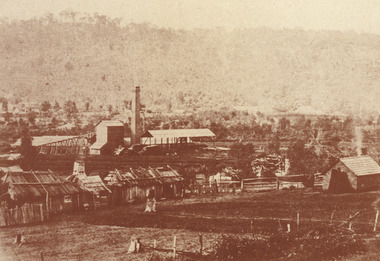
Photograph, est. 1860-1875
... Beechworth is renowned for its hydraulic sluice method of mining. This involved soil being exposed to torrents of water from high-pressure hoses. From 1876 until its closure in 1921, the mine produced an astounding 47,926 ozs of gold. Companies like this were the source of income for many Chinese gold-diggers who sought to make their fortune on the goldfields...Beechworth is renowned for its hydraulic sluice method of mining. This involved soil being exposed to torrents of water from high-pressure hoses. From 1876 until its closure in 1921, the mine produced an astounding 47,926 ozs of gold. Companies like this were the source of income for many Chinese gold-diggers who sought to make their fortune on the goldfields ...In 1875, the Rocky Mountain Extended Gold Sluicing Company Ltd was created, utilising the previous Rocky Mountain claim for the area near Lake Sambell. The company employed A.L Martin to survey an area for a tunnel underneath Beechworth and Johnson Stephens to dig it. The tunnel was built at a rate of 40 feet a month and eventually measured 800 metres. The tunnel was a true accomplishment both in the present and during the 19th century. It was considered to be a marvelous engineering feat. Beechworth is renowned for its hydraulic sluice method of mining. This involved soil being exposed to torrents of water from high-pressure hoses. From 1876 until its closure in 1921, the mine produced an astounding 47,926 ozs of gold. Companies like this were the source of income for many Chinese gold-diggers who sought to make their fortune on the goldfields of Beechworth. During the height of the rush, the town had around 7,000 Chinese inhabitants living on the outskirts of town as they were not permitted to live within Beechworth itself.The search for gold is ingrained into the history of Victoria and therefore, images like this one which portrays an open-cut sluicing site can reveal important information for society and technology for the date when the photograph was taken. This image is of important historical significance for its ability to convey information about sluicing and the methods used to find gold in 1910. It also shows a location where sluicing was undertaken which provides insight into the impact of sluicing on the environment at a time when it was done. This image of the Rocky Mountain mine is historically significant as the mining complex is now non-existent, with the only remains being the tunnel built in 1880 by the company, which was considered one of the greatest engineering feats of the time. The image also provides a first-hand look into the social and cultural networks at play during the 19th century with racial segregation of the Chinese at the 'Chinese Camp', as well as an insight into Beechworth's origins during the Gold Rush.A sepia rectangular photograph printed on matte photographic paper as a postcardReverse: Historic Beechworth / 7792.1 / ROCKY MOUNTAIN MINE / Viewed from the “Chinese Camp”, shown partly in the foreground, we see the central plant of the famous Rocky Mountain Mining Company. This extensive complex, of which nothing remains, was situated between Silver Creek and the present Lake Sambell area. The company was responsible for a tunnel cut through solid bedrock underneath the town of Beechworth and surfacing near the keystone bridge on the Wangaratta side. Completed in 1880 it was declared to be one of the greatest engineering feats in Australia. The tunnel is still basically intact today. / Series by Wooragee Graphics: Historic Beechworth. / COPYRIGHT BURKE MUSEUM / No.72 beechworth, rocky mountain mine, sluicing, gold rush, mining, gold -
 The Beechworth Burke Museum
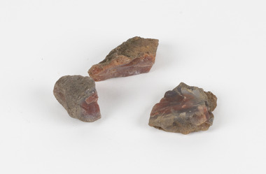
Geological specimen - Unknown, possible Carnelian Agate or Chalcedony
... The discovery of gold in Victoria, for instance, had a significant influence on the development of the area now known as 'the goldfields', including Beechworth; the city of Melbourne and Victoria as a whole. ...Beechworth high-country Although it is not known where these specimens were collected, Victoria and other regions of Australia were surveyed for sites of potential mineral wealth throughout the 19th Century. The identification of sites containing valuable commodities such as gold, iron ore and gemstones in a locality had the potential to shape the development and history of communities and industries in the area. The discovery of gold in Victoria, for instance, had a significant influence on the development of the area now known as 'the goldfields ...Although it is not known where these specimens were collected, Victoria and other regions of Australia were surveyed for sites of potential mineral wealth throughout the 19th Century. The identification of sites containing valuable commodities such as gold, iron ore and gemstones in a locality had the potential to shape the development and history of communities and industries in the area. The discovery of gold in Victoria, for instance, had a significant influence on the development of the area now known as 'the goldfields', including Beechworth; the city of Melbourne and Victoria as a whole. Agate occurs when amygdales (gas pockets) form in the upper levels of basaltic lava flows. If these pockets or bubbles are iniltrated by water bearing silica in solution, the fluid dries and hardens in layers, forming round or egg shaped nodules or geodes within the rocky matrix. Agate is formed of a silica mineral chalcedony similar to quartz. The term carnelian primarily refers to the reddish shading of the stone; whether the stone is termed an agate or chalcedony type is often influenced by the degree of colour banding the specimen shows. The specimens are significant as examples of surveying activity undertaken to assess and direct the development of the mineral resource industries in Victoria and Australia, as well as the movement to expand human knowledge of earth sciences such as mineralogy and geology in the nineteenth century.Three small geological specimens that appear visually consistent with images of rough or unpolished Carnelian Agate or Chalcedony. geological specimen, geology, geology collection, burke museum, beechworth, indigo shire, north-east victoria, gemstones, agate, carnelian -
 The Beechworth Burke Museum
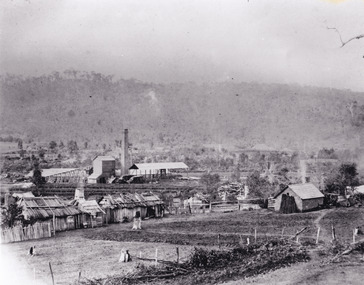
Photograph - Photograph - Reproduction
... Beechworth is renowned for its hydraulic sluice method of mining. This involved soil being exposed to torrents of water from high-pressure hoses. From 1876 until its closure in 1921, the mine produced an astounding 47,926 ozs of gold. Companies like this were the source of income for many Chinese gold-diggers who sought to make their fortune on the goldfields...Beechworth is renowned for its hydraulic sluice method of mining. This involved soil being exposed to torrents of water from high-pressure hoses. From 1876 until its closure in 1921, the mine produced an astounding 47,926 ozs of gold. Companies like this were the source of income for many Chinese gold-diggers who sought to make their fortune on the goldfields ...The photograph is a reproduction of a postcard from the Rocky Mountain Mining Company. In 1875, the Rocky Mountain Extended Gold Sluicing Company Ltd was created, utilising the previous Rocky Mountain claim for the area near Lake Sambell. The company employed A.L Martin to survey an area for a tunnel underneath Beechworth and Johnson Stephens to dig it. The tunnel was built at a rate of 40 feet a month and eventually measured 800 metres. The tunnel was a true accomplishment both in the present and during the 19th century. It was considered to be a marvelous engineering feat. Beechworth is renowned for its hydraulic sluice method of mining. This involved soil being exposed to torrents of water from high-pressure hoses. From 1876 until its closure in 1921, the mine produced an astounding 47,926 ozs of gold. Companies like this were the source of income for many Chinese gold-diggers who sought to make their fortune on the goldfields of Beechworth. During the height of the rush, the town had around 7,000 Chinese inhabitants living on the outskirts of town as they were not permitted to live within Beechworth itself.This image of the Rocky Mountain mine is historically significant as the mining complex is now non-existent, with the only remains being the tunnel built in 1880 by the company, which was considered one of the greatest engineering feats of the time. The image also provides a first-hand look into the social and cultural networks at play during the 19th century with racial segregation of the Chinese at the 'Chinese Camp', as well as an insight into Beechworth's origins during the Gold Rush.Black and white rectangular reproduced photograph printed on paperbeechworth, rocky mountain mine, sluicing, gold rush, mining, gold -
 The Beechworth Burke Museum
Geological specimen - North Queensland Agates, Unknown
... The discovery of gold in Victoria, for instance, had a significant influence on the development of the area now known as 'the goldfields', including Beechworth; the city of Melbourne and Victoria as a whole. ...The discovery of gold in Victoria, for instance, had a significant influence on the development of the area now known as 'the goldfields', including Beechworth; the city of Melbourne and Victoria as a whole. ...Agate occurs when amygdales (gas pockets) form in the upper levels of basaltic lava flows. If these pockets or bubbles are iniltrated by water bearing silica in solution, the fluid dries and hardens in layers, forming round or egg shaped nodules or geodes within the rocky matrix. Agate is formed of a silica mineral chalcedony similar to quartz. Although relatively common and semi-precious, agate has been prized since at least 1450 BC - an intricately carved agate seal was found in the 2015 excavation of a grave belonging to a Mycenaeum priest or warrior near Pylos in Greece. Agate is also used in jewellery and other decorative or ritual purposes due to its often striking appearance. These specimens originated in North Queensland, which contains noted agate-fossicking regions such as in the area surrounding Forsayth. They were collected in approximately 1852 as an adjunct to the Geological Survey of Victoria. It was donated to the Museum in 1868. Victoria and other regions of Australia were surveyed for sites of potential mineral wealth throughout the 19th Century. The identification of sites containing valuable commodities such as gold, iron ore and gemstones in a locality had the potential to shape the development and history of communities and industries in the area. The discovery of gold in Victoria, for instance, had a significant influence on the development of the area now known as 'the goldfields', including Beechworth; the city of Melbourne and Victoria as a whole. The specimens are significant as examples of surveying activity undertaken to assess and direct the development of the mineral resource industries in Victoria and Australia, as well as the movement to expand human knowledge of earth sciences such as mineralogy and geology in the nineteenth century. Two solid egg-sized pieces of peach/orange toned agate (a common semi-precious chalcedony, similar to quartz) with a striped pattern, embedded in a light and dark brown matrix. geological specimen, geology, geology collection, burke museum, beechworth, agate, north queensland agate, 1852 geological survey of victoria, l. hufer - donor, mineralogy, agate specimen, indigo shire -
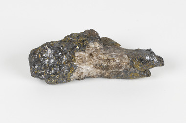 The Beechworth Burke Museum
Geological specimen - Sphalerite, Unknown
... The discovery of gold in Victoria, for instance, had a significant influence on the development of the area now known as 'the goldfields', including Beechworth; the city of Melbourne and Victoria as a whole....The discovery of gold in Victoria, for instance, had a significant influence on the development of the area now known as 'the goldfields', including Beechworth; the city of Melbourne and Victoria as a whole. ...Sphalerite or sphaelerite is named from the Greek word for 'treacherous' or 'deceiver' as specimens can vary widely in appearance, making them hard to visually identify. It is a zinc sulfide with the chemical composition (Zn,Fe)S, the most important ore of zinc. Specimens of sphalerite can contain iron as a substitute for up to 25% of the usual zinc present, as well as trace elements of gallium, cadmium, geranium and indium. Small amounts of arsenic and manganese may also be detected. Sphalerite is found in igneous, sedimentary and metamorphic rocks. It forms when carbonate rock encounters acidic, zinc-bearing fluid. It often forms in veins or in fissures of the existing rock, with colours and crystal shapes dependent on the composition of the the combining elements. It forms isometric crystal shapes including cubes, tetrahedrons, octahedrons, dodecahedrons. This specimen was collected in approximately 1852, in Broken Hill, NSW, as an adjunct to the Geological Survey of Victoria. It was donated to the Museum in 1868. Victoria and other regions of Australia were surveyed for sites of potential mineral wealth throughout the 19th Century. The identification of sites containing valuable commodities such as gold, iron ore and gemstones in a locality had the potential to shape the development and history of communities and industries in the area. The discovery of gold in Victoria, for instance, had a significant influence on the development of the area now known as 'the goldfields', including Beechworth; the city of Melbourne and Victoria as a whole.The specimen is significant as an examples of surveying activity undertaken to assess and direct the development of the mineral resource industries in Victoria and Australia, as well as the movement to expand human knowledge of earth sciences such as mineralogy and geology in the nineteenth century.A pipe-shaped specimen of sulfide-mineral zinc ore displaying patches of black, brown, beige and gold colouring. The main item has associated broken pieces. geological specimen, geology, geology collection, burke museum, beechworth, mineralogy, indigo shire, geological survey, sphalerite, sphaelerite, zinc ore, broken hill, nsw, victoria, galena, fluorite, chalcopyrite, lead, cadmium, gallium, germanium, indium, iron -
 The Beechworth Burke Museum
Audio - Oral History, Jennifer Williams, Desmond McIntosh, 27 July 2000
... Desmond (Des) McIntosh was born in Beechworth in the old goldfield’s hospital in 1940. He was the third child born in a family of five children. ...The Beechworth Burke Museum Loch Street Beechworth high-country Desmond (Des) McIntosh was born in Beechworth in the old goldfield’s hospital in 1940. He was the third child born in a family of five children. ...Desmond (Des) McIntosh was born in Beechworth in the old goldfield’s hospital in 1940. He was the third child born in a family of five children. His great-grandparents moved from Scotland to Yackandandah in the 1930s to pursue wealth in the gold boom, but only just made a living out of it. His grandfather eventually moved and lived in the Woolshed Valley, where Desmond’s parents came from. His family continued to live in the Woolshed Valley as dairy farmers until the 1950s and then moved to Beechworth. Desmond went to school in Wooragee but left when he was 15 to work as a salesman at Freeman’s Store in Beechworth. He worked there for nine years, and then started working in the prison service in Beechworth at what is now known as the Old Beechworth Gaol, or HM Prison Beechworth, where he worked for 27 years. Desmond was an active member of the Beechworth community outside of the Prison in the church and an APEX member (which is a social justice program run across Australia). In prison, he led work programs for the prisoners such as a gardening program where they grew the fresh vegetables and fruit that they would eat. This oral history recording was part of a project conducted by Jennifer Williams in the year 2000 to capture the everyday life and struggles in Beechworth during the twentieth century. This project involved recording seventy oral histories on cassette tapes of local Beechworth residents which were then published in a book titled: Listen to what they say: voices of twentieth century Beechworth. These cassette tapes were digitised in July 2021 with funds made available by the Friends of the Burke.Mr. Desmond McIntosh’s account of his life in Beechworth and the local area during the 20th century is historically and socially significant to the cultural heritage of the region. He details some of the change that occurred across Beechworth over time, as well as details about the management of the Old Goal Beechworth. His account is important to the region's history in terms of social issues and the effect WWII has on Beechworth. This oral history account is socially and historically significant as it is a part of a broader collection of interviews conducted by Jennifer Williams which were published in the book 'Listen to what they say: voices of twentieth-century Beechworth.' While the township of Beechworth is known for its history as a gold rush town, these accounts provide a unique insight into the day-to-day life of the town's residents during the 20th century, many of which will have now been lost if they had not been preserved.This is a digital copy of a recording that was originally recorded on a cassette tape. The cassette tape is black with a horizontal white strip and is currently stored in a clear flat plastic rectangular container. It holds up to 40 minutes of recordings on each side. Mr. Desmond McIntoshlisten to what they say: voices of twentieth century beechworth, beechworth, oral history, burke museum, desmond mcintosh, old goal beechworth, apex, wooragee, hm prison beechworth, woolshed valley, scotland, dairy farmer, freeman's store, gardening, garden, social justive -
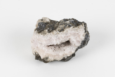 The Beechworth Burke Museum
Geological specimen - Dolomite
... The discovery of gold in Victoria, for instance, had a significant influence on the development of the area now known as 'the goldfields', including Beechworth; the city of Melbourne and Victoria as a whole. ...The discovery of gold in Victoria, for instance, had a significant influence on the development of the area now known as 'the goldfields', including Beechworth; the city of Melbourne and Victoria as a whole. ...Dolomite is a mineral, calcium magnesium carbonate, with the chemical formula CaMg(CO3)2. It is a principle component of various rock types sometimes also referred to as dolomite, including dolostone, dolomitic marble and dolomitic limestone (according to the composition of each type). Dolomite rock is found in sedimentary basins throughout the world, comprising approximately 2% of the Earth's crust. It is formed when lime mud or limestone encounters groundwater containing magnesium. Dolomite can contain elements such as lead, zinc and copper. Dolomite and limestone are used in various construction, landscaping and agricultural processes. This specimen was donated to the Burke Museum in 1868 by Alfred Selwyn as part of the Geological Survey of Victoria. It was donated to the Museum in 1868. Victoria and other regions of Australia were surveyed for sites of potential mineral wealth throughout the 19th Century. The identification of sites containing valuable commodities such as gold, iron ore and gemstones in a locality had the potential to shape the development and history of communities and industries in the area. The discovery of gold in Victoria, for instance, had a significant influence on the development of the area now known as 'the goldfields', including Beechworth; the city of Melbourne and Victoria as a whole. Dolomite and limestone are mined at several locations in Victoria, including sites in the North-East of the state in Bindi and Limestone Creek. There are notable dolomite deposits in most Australian states. The dolomitised form of the mineral tends to come from older limestone deposits, formed during the palaeozoic era in marine settings, so this specimen may have come from a deposit located along a coastline in Victoria or another state. The specimen is significant as an example of surveying activity undertaken to assess and direct the development of the mineral resource industries in Victoria and Australia, as well as the movement to expand human knowledge of earth sciences such as mineralogy and geology in the nineteenth century. This specimen is part of a larger collection of geological and mineral specimens collected from around Australia (and some parts of the world) and donated to the Burke Museum between 1868-1880. A large percentage of these specimens were collected in Victoria as part of the Geological Survey of Victoria that begun in 1852 (in response to the Gold Rush) to study and map the geology of Victoria. Collecting geological specimens was an important part of mapping and understanding the scientific makeup of the earth. Many of these specimens were sent to research and collecting organisations across Australia, including the Burke Museum, to educate and encourage further study.Hand-sized piece of pale pink dolomite (calcium magnesium carbonate) with dark grey rim and hollowed centre. geological specimen, geology, geology collection, burke museum, beechworth, dolomite, mineralogy, geological survey, alfred selwyn, limestone, calcium magnesium carbonate -
 The Beechworth Burke Museum
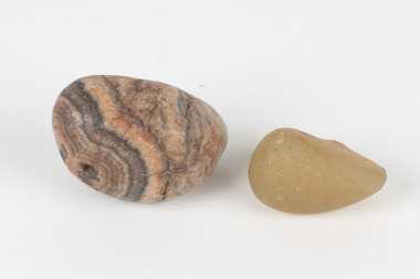
Geological specimen - Agate and Quartz pebbles
... The discovery of gold in Victoria, for instance, had a significant influence on the development of the area now known as 'the goldfields', including Beechworth; the city of Melbourne and Victoria as a whole....The discovery of gold in Victoria, for instance, had a significant influence on the development of the area now known as 'the goldfields', including Beechworth; the city of Melbourne and Victoria as a whole. ...Agate occurs when amygdales (gas pockets) form in the upper levels of basaltic lava flows. If these pockets or bubbles are iniltrated by water bearing silica in solution, the fluid dries and hardens in layers, forming round or egg shaped nodules or geodes within the rocky matrix. Agate is formed of a silica mineral chalcedony similar to quartz. Although relatively common and semi-precious, agate has been prized since at least 1450 BC - an intricately carved agate seal was found in the 2015 excavation of a grave belonging to a Mycenaeum priest or warrior near Pylos in Greece. Agate is also used in jewellery and other decorative or ritual purposes due to its often striking appearance. Quartz is found all over Australia, including Beechworth in Victoria. It is formed in deep-seated igneous rocks and crystallized through hot aqueous solutions. It can have two forms; Microcrystalline quartz or Crystalline quartz. Microcrystalline quartz is a fine grain quartz where crystalline quartz is often a large crystal. The colour of quartz can vary. These specimens were collected in Victoria in the vicinity of the Burke Museum. Victoria and other regions of Australia were surveyed for sites of potential mineral wealth throughout the 19th Century. The identification of sites containing valuable commodities such as gold, iron ore and gemstones in a locality had the potential to shape the development and history of communities and industries in the area. The discovery of gold in Victoria, for instance, had a significant influence on the development of the area now known as 'the goldfields', including Beechworth; the city of Melbourne and Victoria as a whole.The specimens are significant as examples of surveying activity undertaken to assess and direct the development of the mineral resource industries in Victoria and Australia, as well as the movement to expand human knowledge of earth sciences such as mineralogy and geology in the nineteenth century.Geological specimens of Agate and Quartz respectively; the fist-sized piece of Agate has peach/coral colouring with grey concentric patterning and the smaller piece of quartz is a uniform yellow/orange shade. Existing label: Local pebbles / (agate and / quartz / (yellowish) / egg-shaped). / BB geological specimen, geology, geology collection, burke museum, beechworth, agate, quartz, north-east victoria, indigo shire, geological surveys -
 Bendigo Military Museum
Education kit - EDUCATION KIT - CD'S AND PAPERWORK, Catholic College Bendigo, Nov 2012
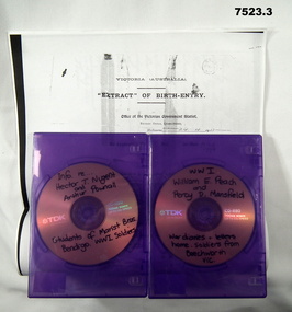
... goldfields Catholic College Bendigo school project. Two digital backup CD copies and one collection of research paperwork for three folders. Related folders Cat No. 4958, 4959, 4960. CD War Diaries WW1 Education Handwritten label on CD. 1. "Info/re Hector T Nugent/and/Arthur Pownall/ Students of Marist Bros/ Bendigo. WW1 Soldiers." 2. "WW1 William E. Peach and Percy D. Mansfield/ War diaries & letters/ home. Soldiers from Beechworth ...Catholic College Bendigo school project. Two digital backup CD copies and one collection of research paperwork for three folders. Related folders Cat No. 4958, 4959, 4960.1. CD with plastic storage cover. Handwritten label on CD. 2. CD with plastic storage cover. Handwritten label on CD. 3. 12 pages A3 size - facsimile research paperwork. Handwritten label on CD. 1. "Info/re Hector T Nugent/and/Arthur Pownall/ Students of Marist Bros/ Bendigo. WW1 Soldiers." 2. "WW1 William E. Peach and Percy D. Mansfield/ War diaries & letters/ home. Soldiers from Beechworth, Vic.cd, war diaries, ww1, education -
 Bendigo Military Museum
Booklet - FOLDER, WAR DIARY, Catholic College, Bendigo. School project, "THIS BOKK HOLDS WAR DIARY FROM WILLIAM E. PEACH
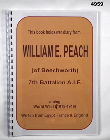
... Bendigo Military Museum 37 - 39 Pall Mall Bendigo goldfields "'WILLIAM E. PEACH ( of Beechworth) 7th Battalion A.I.F. during WW1 (1915-1916) Written from Egypt, France and England" Folder War Diaries AIF WW1 Folder with clear plastic binding comb. ..."'WILLIAM E. PEACH ( of Beechworth) 7th Battalion A.I.F. during WW1 (1915-1916) Written from Egypt, France and England"Folder with clear plastic binding comb. Cover- front clear plastic, back black coloured cardboard. Title page- paper, brown, print on orange coloured background. Pages - not numbered paper, plain, white . Facsimile containing printed items, documents and photographs.folder, war diaries, aif ww1 -
 Bendigo Military Museum
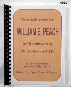
Booklet - FOLDER, WAR LETTERS, Catholic College Bendigo - School project, This book holds the letters from William E Peach
... Bendigo Military Museum 37 - 39 Pall Mall Bendigo goldfields William E Peach (of Beechworth) 7th Battalion AIF. ...William E Peach (of Beechworth) 7th Battalion AIF. "to his mother during/ Worl War 1 (1915-1916)/ written from Egypt, France and England.Folder with black plastic binding comb. Cover - front clear plastic, bac - black coloured cardboard. Title page - paper, brown print on orange coloured background. Pages (not numbered), paper, plain, white, Facsimile containing printed items and a photograph.folder, war letters, ww1 -
Federation University Historical Collection
Document, Zelda Martin, Central Victorian Goldmining towns - Boom Towns or Ghost Towns?, c1996
... Beechworth.. Official staff in each gold district consists of a Resident Warden, Wardens, Wardens' Clerks, Bailiffs, Chinese Protectors, Chinese Interpreters, and Mining Surveyors. *Gold Receiver *Gaols *Police magistrates and Clerks of Petty Sessions, etc. *Field Branch *Immigration and Emigration Overland - Chinese - 1859 *Population on the Goldfields...Beechworth.. Official staff in each gold district consists of a Resident Warden, Wardens, Wardens' Clerks, Bailiffs, Chinese Protectors, Chinese Interpreters, and Mining Surveyors. *Gold Receiver *Gaols *Police magistrates and Clerks of Petty Sessions, etc. *Field Branch *Immigration and Emigration Overland - Chinese - 1859 *Population on the Goldfields ...Zelda Martin was a PhD candidate at the University of Melbourne.[.1] 4th item in light blue display book titled Research Approach/Overview of Chapters/Confirmation of Canditure/Chapters1,2,3&4 of proposed thesis. *Twenty-seven page article on Victorian goldfields towns titled: Central Victorian Goldmining Towns - Boom Towns or Ghost Towns. The article was written during the author's PhD study. It outlines the context methodology, and resources and the chapters of the proposed thesis: (1) Central Victorian Goldmining Towns - The Context (2) Contemporary Views of the Factors Necessary for Town Growth (3) Outward Manifestations of Town Growth (4) The Trappings of Government (5-9) The Main Towns and Their Hinterland. [.2] 5th item in Light Blue display book as above item. *Chapter 1 of proposed thesis titled 'Pick, Shovel and Tin Dish Mining.' Covers in Section A: Central Victoria - Pre 1851: Aborigines in Central Victoria, Squatters, and Government. Section B: The years 1851-1854: The Early Gold Rushes, Government Reaction, Township Surveys, Legislation, Town Development, Local Government and Early Settlement. [.3] 6th item in Light Blue display book as above item. *2A of proposed thesis titled 'Contemporary Views of the Factors Necessary for Town Growth'. Similar information to Chapter 1 plus extra re towns and maps. Sections: Introduction, Context of Place - Geographical Towns Listed, The Context of Time - Pre1851 Aborigines, Governance of Port Phillip, The Squatters, The Villages of Central Victorian Highlands, Conclusion, Condensed Version of Chapter2B. [.4] 7th item in Light Blue display book as above item. *Chapter2B of proposed thesis. Sections: Area of Research, Schools, Banks, Newspapers, Progress Association, Town Development - Sandhurst (Bendigo), Ballarat, Castlemaine,, Maryborough, Ararat and Stawell. [.5] 8th item in Light Blue display book as above item. *Chapter 3 of proposed thesis titled 'Outward Manifestations of Town Growth'. Sections: Introduction, Contemporary Writing, Educationalists, The Bankers, The Townsfolk, Current Theory, General Theories of Urban Development, and Conclusion. [.6] 9th item in Light Blue display book as above item. *Chapter 4 of proposed thesis titled 'Trappings of Government' Sections: Introduction, Early Government Attitudes to Mining and Town Development, Law and Order, Township Surveys, Legislation, Local Government, Transport and Communication, The People and Lobbyists. [.7] 10th item in Light Blue display book as above item. *'The Rise and Fall of Central Victorian Goldmining Towns'. Includes a map showing main Goldfields, a table showing towns and villages at two points in time - 1857 and 1871; a Bibliography of Primary and Secondary Sources. [.8] Resource No1. Black display book titled Local Towns 1 : Alma: *Brief history *Directory *Maps Amphitheatre / Mountain Hut: *Brief History Post Office Directory Ararat: *Brief History *Post Office Directory 1869 - Alphabetical Listing by Occupation *Ararat - Prominent Citizens of 1858 *Langi-Morgala Museum Avoca: *Brief History *Excerpts from 'Avoca The Early Years', Margery and Betty Beavis; pg1 - Beginnings; pg11 - The Midas Touch; pg25 - Local Gold Escorts; pg27 - A Town is Born; pg51- The Administration of Justice; pg53 - The Ways of the Law; pg61 - News of the Day; pg65 - A Time to Play; pg72 - Land Ownership *Post Office Directory (Bailliere's) 1869 *Tourism Map and Information of area *Historic Avoca - A 5.5km Tour *Avoca & the Pyrenees Region - information pamphlet Ballarat: *Early History of Ballarat - Ballarat Historical Society, Publication No.1: origin of the name; Ballaarat - the Beginning; Fabulous Yields from the Ballaarat Goldfield; *Streetscape Lydiard Street. *Hand drawn map showing Leigh River, Old Portland Bay Road, plaque on road to Colac; etc. *Newspaper article re 'The Theatre Royal' ( which stood in the vicinity of the current Owen Williams store) - 'The News'15/04/1998 *Article - 'Ballarat's Mechanics' Institute Lives On' Ballarat Courier, 14/09/1985 *Article - Standing the Test of Time' The News 17/11/1993 re The Mechanics Institute & picture of the Reading Room *'Ballarat a Study of a City, Phyllis Reichl, pub. Nelson, 1968; no.3 place, time and people field studies series *Investigator Vol.33 No.2, 1998 Geelong Historical Society. Article on pg75 describes Ballarat in 1861 *Folded poster - 'Ballarat 100' a history of telegraph communication, pub. Telecom. Beaufort (Fiery Creek): *Brief history *Post Office Directory [.9] Resource No.2 Black Folder Titled Towns cont.No2 Bendigo (Sandhurst): *'Family & Local History at the Bendigo Library - 1851-2001 150 years of gold'. *Bendigo Government Camp in 1853 illustration; key to sketch and names of Government officers stationed there *Excerpts from 'Bendigo and Vicinity' Adolph Haman *The Bendigo Goldfield Registry - pgs 1-7 Introduction *Excerpt: 'Breaking the Grip' *Excerpt: The Most Go-Ahead Place *Excerpts from 'History of Bendigo' - anti license agitation; laying out of town; proposed railway; gold calls and dividends; the Sandhurst Municipality; journalism *Bibliography Blackwood: *Excerpts from 'Aspects of Early Blackwood - The Goldfield, the Landmarks, the Pioneers' Alan J Buckingham and Margaret F Hitchcock, JG Publishing,1980 Buninyong: *A Brief History *Investigator Vol1 No.2 Feb 1966 Geelong Historical Society. Pg3 - Article re gold escort route - Mt Alexander to Adelaide - (see a simple monument on the Western Highway a few miles out of Horsham. Pg 15 - Ballarat Excursion - re the finding of gold. *Three articles published by Buninyong and District Historical Society Inc: (Magpie Exploration; Finding Gold In The Green Hills; Magpie Exploration; Burnt Bridge to Cargarie to Mt Mercer) *Copies of newspaper articles/items *Buninyong Street Directory Carisbrook: *In the Beginning There Was Carisbrook *The History of the Carisbrook Racecourse Carngham / Snake Valley: *Brief History *Directory Castlemaine: *Directory 1865-1866 - Alphabetical and Street *Poster - Castlemaine A Contemporary Guide "The Great Centre" 1866 - A Contemporary Guide to the Fascinating Past *Pamphlet - Castlemaine District Community Hospital *Map - Castlemaine, Maldon & Surrounding Districts *Map and Information - The Dry Diggings Track - a 55kl walk among historic goldfields relics ( Castlemaine Fryerstown Vaughan Mt Franklin Hepburn Daylesford) *Postcard - Former Court House *Directory 1867 - Alphabetical, Trade [.10] Resource No.3 Grey folder Titled Towns 3 Creswick to Maryborough Creswick: *Brief History *Booklet - "Creswick Cemetery Walk" *Booklet - The Buried Rivers of Gold Heritage Trail Creswick *Creswick Historical Museum Information Sheet *Chronological History of Creswick *Alphabetical Directory of the Borough of Creswick *Creswick's Creek Directory 1856 *Historic Creswick Walking Tour *A Brief Account of the Schools of Creswick - Past and Present *100 Years of Railway Travel in Creswick *The Berry Deep Leads *The Spence Home at Jackass Gully in the Creswick State Forest ( William Guthrie Spence - Pioneer) *The New Australian Mine and the 1882 Disaster *Creswick District News, Issue 7, July August 1999 *The Creswick Miners Walk - Information and Map *Maps Chewton: *Brief History *Directory Clunes: *Brief History *Clunes Street Directory Daylesford: *Brief History *Notable Bushfires in Daylesford District Over More Than a Century - "Black Thursday" 1851; 1862; 1899; the Disastrous Hepburn Fire of 1906; 1939; 1944; 1969. *Post Office Directory -Daylesford and Hepburn Dunolly / Inkerman: *Brief History *Directory *Pamphlet - Goldfields Historical Museum *Pamphlet - Historic Dunolly - Victoria's Best Kept Secret *Map of Gold Workings at Dunolly Area - showing where the main gold rushes occurred *Brief History - Inglewood *Directory - Inglewood - Name Occupation, Dwelling Kingower: *Brief History *Directory - Name / Ocupation / Dwelling Linton / Happy Valley / Piggoreet: *Brief History *Directory - Lintons McIvor: *"A History of the Shire and the Township of Heathcote" by J.O. Randell Majorca: *Brief History *Official Post Office Directory 1869 - Name / Occupation/ Address Maldon (Tarrangower): *Brief History Part 1 *Brief History Part 2 *Post Office Directory *List - Alphabetical Order by Names plus Business and Trade (Tarrangower Times Oct/1858) *List - Alphabetical Order by Trade plus Name and Business *Directory - Name / Occupation / Dwelling Maryborough: *Worsley Cottage - built by Arthur Worsley, a contractor in stonework in 1894 [.11] Resource No. 4 Blue Display Book titled Towns 4 Moliagul to Stawell Moliagul: *Brief History *Moligul Legislative Assembly (Voting?) List - Names and Occupations *Moliagul Victorian Post Office Directory 1868 - Name / Ocupation / Address / Comments *"The Welcome Stranger" gold nugget *The Sunday School *The Welcome Stranger Discovery Walk - information and map Moonambel (Mountain Creek) Redbank *Brief History *List of names extracted from advertisments of the Pioneer and Mountain Creek Advertiser 16/02/1861. *Bailliere's Directory 1869 - Alphabetical List of Name / Occupation / Place St Arnaud: *Brief History Sebastapol: *Brief History *Directory 1869 - Alphabetical by Name; plus occupation and address. Browns and Scarsdale: *Brief History *Browns Street Directory - Name and Occupation Smythesdale: *Brief Description *Smythesdale Street Directory -Name and Occupation Stawell (Pleasant Creek) *Brief History *Victorian Official Post Office Directory - Name /Occupation / Dwelling *Chronology - 1841-1920 *Production of gold statistics - 1879 - 1900 *Big Hill *Extracts from "The Golden Years of Stawell". Chapt 1 - Stawell's Coming Out. Capt. 2 - The Gold Rush. Caapt.3 - Cradle of Democracy. Chapt.4 - The Reefs Becomes Stawell. Chapt. 5 - Rushing In. Chapt.6 - The Pioneers. Chapt 7 - The Decade of Optimism. [.12] Resource No. 5: Blue Display Book titled 'Towns Steiglitz to the The Golden Triangle. Steiglitz: Brief History Victorian Post Office Directory 1869 *Map of Steiglitz *List of maps relevant to Steiglitz history *Information 6 tables of data from "Reports of Mining Surveyors Talbot (Back Creek) Brief History Taradale: Post office Directory 1869 - Name/Occupation/Street. Also list in alphabetical order by Occupation Taradale *Chronological Reference to Taradale Mines *Water - The Coliban System of Waterworks *Joseph Brady *The Syphon Tarnagulla (Sandy Creek) *Brief History *Tarnagulla Businessmen Cameos to give depth to advertisments in 'The Tarnagulla Courier' various issues 1864-1871 *Directory - Name/Occupation /Address *List - Name/Business/Trade Wedderburn (Koorong) *Brief History *List - Name/Occupation The Golden Triangle: *The Early Rushes - Wedderburn / Moliagul / Sandy Creek - Tarnagulla / Jones Creek - Waanyarra / Kingower / Dunolly - Goldsborough / Inglweood *Census of 1857 - Population / Occupations *1858-1871 - A Time of Consolidation- Wedderburn / Moliagul / Sandy Creek- Tarnagulla / Arnold *Census 1871 - Population *Information gleaned from the census data - Demographics / Population / Occupations / marital / Birthplace / Religion / Literacy/ Occupation and Housing Cameos *Graphs - Birthplace of settlers /Male-Female Ratio / Married males / Children under 15 as Percentage of Population / Religion *Census 1857 - Statistical data *Maps *Bibliography [.13] Resource No. 6 - Black Display Book Information and Research in Central Victoria including: *Banking - Research from ANZ Bank Archives *Institutions - also includes articles listed from the Ballarat Times Newspaper *Australian mining History Association - A.M.H.A. Bibliography *Australia's Mining History * Bibliography - Land Surveys Victoria - *1853 Administration (Statistics and Other) includes: schools / ministers of religion / police / military / local administration / licences for sale of spirits / distances between various Victorian gold fields. * Victoria Government Gazette (Copy) - N0. 116, 12/12/1854 includes: Gold Felds Commission of Enquiry & No. 85, 15/09/1854 - Addresses presented to the Lieutenant Governor (Sir Charles Hotham) during his tour through the Gold Fields of Victoria,1854. Addresses on behalf of : the people of Bendigo; Members of the Church of England, Bendigo; Members of the Wesleyan Church on the Bendigo Gold Fields; Bendigo Gold District General Hospital; the Bendigo Prospecting Association; Committee of the Bendigo Local Exhibition; Bendigo District Medical Association; Coloured Americans Resident at Bendigo; German Inhabitants of Bendigo; Landowners, Inhabitants, and Miners of Castlemaine; Inhabitants of Forest Creek; Inhabitants of Heathcote and Gold Miners of McIvor; Residents and landholders of the District of Bacchus Marsh; Inhabitants of Kilmore and Vicinity. *Gold Fields Correspondence 1853: letter from Lieutenant Colonel Valiant, (Officer commanding the Troops in Victoria) to the Lieutenant Governor re threatened disturbance at Sandhurst (Bendigo) regarding the Gold License Fee. * Extracts from a book "Victoria" re Gold Fields Commission of Enquiry involving mainly Ballarat and Castlemaine and a chapter titled 'A Tour to the Victorian Gold-Fields' *Lists of central Victorian newspapers - listed by date published 1851to 1874; by first date available to State Library. *A list of cities and towns showing County, population in 1861 &1871, and municipal status. [.14] Resource no.7. Black display book. *Reference: Papers presented to Parliament Victoria - 1859-1860 4 volumes - relevant sections copied. Contains information on Branches of Government. General / Finance / Gold / Gazette / Commission and Warrant / Statistic. *Gold Fields Act. In accordance with the Act the gold fields are divided into six districts - Ballaarat, Castlemaine , Sandhurst, Avoca, Ararat, and Beechworth.. Official staff in each gold district consists of a Resident Warden, Wardens, Wardens' Clerks, Bailiffs, Chinese Protectors, Chinese Interpreters, and Mining Surveyors. *Gold Receiver *Gaols *Police magistrates and Clerks of Petty Sessions, etc. *Field Branch *Immigration and Emigration Overland - Chinese - 1859 *Population on the Goldfields *The Geological Survey - The Government Geologist is assisited by staff from four branches - the office Branch; the Publishing Branch; the Field Branch and the Museum Branch. *Commission to Enquire Into Sludge dated 10/02/1859 (Some sections copied) - Report to the Honorable Chief Commissioner of Public Works, Melbourne re the mode of carrying the sludge from the puddling mills in Sandhurst without interfering with the drainage of the town and the roads in the neighbourhood. [.15] Resource No.8: Camel display book titled Resource No. 8. Aborigines *Lists of book titles - +"Readings in Victorian prehistory" +"The Aborigines of Port Phillip" +Aboriginal languages and clans" +"A History of the Port Phillip District" +"Langi Ghiran 1: Aboriginal Rock...." +"Koorie History: sources for aboriginal studies in the State Library of Victoria", ed. Tom Griffiths, Melb. Friends of the State Library, 1989 +"The Public Lands of Australia Felix"; settlement and land appraisal in Victoria1834-91 with special reference to the Western Plains", J.M.Powell, Melb. Oxford University Press 1970 +*Bibliography of the Victorian Aborigines' from the earliest manuscripts to 31st December 1970, Massoa, Aldo, Melb. Hawthorn Press, 1971 +"Aborigines in Colonial Victoria, 1836-1886", M.F. Christie, Sydney University Press, 1979 +"Urban and Industrial Australia: readings in Human Geography" ed J.M. Powell, Melb. Sorrett Pub. 1974 *Extracts: -Processes of Pioneer Settlement - The Squatting Occupation of Victoria, 1834-60. J.M. Powell -Areal Variations in the Class Structure of the Central-Place Hierarchy. P. Scott - Volume1 and Volume 2: Notes Relating to the Habits of the Natives of Other Parts of Australia and Tasmania. Compiled from various sources for the Government of Victoria by R Brough Smyth. John Curry, O'Neil, Melb. 1st pub. Melb. 1876. p31-45 - Numbers and Distribution of the Aborigines in Victoria -Victorian Aborigines 1835-1901 - A Resource Guide to the Holdings of the Public Record Office, Victoria; published by the Government Information Centre 1984. *History of the Aboriginal Artefacts Displayed in the Daylesford Museum. F. G. Powell (4 page pamphlet) *Letter to Zelda Martin from Peter Lovett, Cultural Officer, Ballarat & District Aboriginal Co- Operative, 05/02/1997 *Map: Ian Clarke Victorian Tribunal Boundary Map - Clans of Central Victoria. *Victorian Rock Art and Mythology - Article about Mount Langhi Ghiran and myths of the Tjapwarong people. *Two Aboriginal myths relating to the Grampians - 'The Monster Emu' / 'The Aquisition of Fire', by the Aborigines in the Grampians Areas *Article titled (chapter 8) Ballarat - information re camping sites in the region. Lake Wendouree / Lake Burrumbeet (includes a myth) / Mt Bunninyong / Lal Lal / Pitfield / Mount Elephant / Mount Egerton / Meredith / Lake Goldsmith / Lake Learmonth / Ercildoune *Notes on the Aborigines of the Wider Ballarat Region plus European names=Aboriginal names. John Morris 26/07/1995 *Role of Aborigines in Town Development in Central Victoria. Mentions Native Police Force est. in Port Phillip 1842 and Central Board for Aborigines est. 1860 *The Grave of King Billy. (Frank Wilson) Pamphlet. *Camping Places in Central and Northern Victoria. Article re Lake Burrumbeet site. *Programme for the Unveiling of Memorial Cairn for Edward Stone Parker 1802-1865. Note portrait not accurate. Accurate portrait is available in the book "A Successful Failure A Trilogy The Aborigines and Early Settlers", Edgar Morrison, Graffiti Publications, 2002. * Large envelope addressed to Mr G Netherway containing newspaper cuttings regarding the life of Edward Stone Parker, the unveiling of the Memorial Cairn as mentioned above, articles titled 'Episodes from Our Early Days' (Edgar Morrison, Yandoit)- The Black's School, A School At Last and The Final years. Also a typed page titled 'Historical Background to E.S.Parker's Career. Includes an interesting tale titled 'When the cat lay doggo' re laying power leads for the unveiling ceremony at the memorial site. [.16] green display folder titled 'Research Aids' *List of references to Commissioners' & W'ardens' Reports (formerly held at La Trobe Library Archives, now at Public Records Office [PRO]). Indicates town referred to / date of report / name of camp if different to town. * Archive information re Anglican Records *Movement around the Goldfields - Miners and Storekeepers - usefulness of newspapers in providing information - areas covered - Castlemaine, Maldon, Ararat, Stawell, Tarnagulla, Dunolly. *Port Phillip /Victoria Directories 1839/1867 - Chronological list of Directories included in this series. *"Notes on the History of Local Government in Victoria" A.W. Greig Melb. University Press 1925 - Photo-copied extract p5-p40. (Source - Deakin University Library) - Introduction by W.Harrison Moore. Section 1 - Development in New South Wales Before Separation. Section 2 - Development in Victoria After Its Separation from New South Wales. Hand written notations: 'roads, markets, and local government 1855 on' ;'opportunity of squatters in parliament' and 'opportunities of matters in parliament p33' * Notes on the Establishment of Surveyor General's Department 1851and Commissioner of Crown Lands and Survey. * Newspaper articles from The Argus, 1849, re the discovery of gold in the Pyrenees region. * Excerpt - a report on schools - A.B.Orlebar, Inspector; re the need for permanent school buildings rather than tents. *Excerpt from - 'Approaches to Urban History', Sean Glynn: The Case for Caution * Except from - 'The Urban Sprinkle', Weston Bate: Country Towns and Australian Regional History *Reference- 'The History of Land Tenure in the Colony of Victoria', John Quick. References the Haines Land Bill, land tenure and Land Leagues. [.17] Light blue envelope folder titled 'Birtchnell's Ballarat, etc. Directory 1862 *Contains various directories for Smythesdale, Buninyong, Clunes, Brown's and Creswick. [.18] Red envelope folder no.2 titled Victorian Gazetteer *Selected pages from 1869 Victorian Gazetteer on A4 paper (with a handwritten note questioning if some pages are from 1868 Victorian Gazetteer as appears to be different sizes - A3 pages.) Information includes locations and descriptions of towns, hotels, banks, communications and populations. (Does not include names, residences and occupations) [.19] Red Envelope folder titled Bailliere's Official Post Office Directory 1868 (or1869 or a mixture of both?) *Preface *Contains a selection of pages of towns highlighted in yellow in the the index *Work on this directory was commenced in 1867. *Information includes: Municipalities - mayors and councilors; lists of towns naming male inhabitants and their occupations. [.20]Yellow manila folder titled Post Grad Seminar Presentation 1996 *Gives some background to Zelda Martin's proposed thesis and why she chose the topic Gold Mining Towns Boom or Bust [.21] A3 display book - No. 1A * A list of 'Relevant Newspapers collected: The Tarrangower Times and Maldon Advertiser (first published 1858) Includes dates 1858-1867. The Mount Alexander Mail. Includes dates 1854-1866 The Tarnagulla Courier. Includes dates from1864-1871 Dunolly and Burnt Creek Express. Includes dates from 1862-1871 * Selection of newspaper pages from The Mount Alexander Mail 1854 to 1856, mostly showing advertisements for businesses and services provided to that community. [.22] A3 display book - No. 1B * Selection of newspaper pages from The Mount Alexander Mail 1857 to 1866, mostly showing advertisements for businesses and services provided to that community. [.23] A3 display book -No. 2 * Selection of newspaper pages from The Tarnagulla Courier 1864 to 1871, mostly showing advertisements for businesses and services provided to that community. [.24] A3 display book - No. 3 *Selection of newspaper pages from The Tarrangower Times (and Maldon and Newstead) Advertiser 1858 to1867, mostly showing advertisements for businesses and services provided to that community. [.25] A3 display book - No.4 * Selection of newspaper pages from The Dunolly and Burnt Creek Express; and The Dunolly and Betbetshire Express 1862 to 1871, mostly showing advertisements for businesses and services provided for that community. [.26] A3 display book - No.5 Includes: * Bryce Ross's Diggings Directory. Includes instructions for using this directory. This directory was used by "all persons having connexion or desiring to communicate with 'working parties, private friends, or Stores at the Diggings." As a directory for each area wwas completed it was published in each month's issue of Bonwick's "Digger's Magazine." Years c1852/1853. This Directory commences first at the head of Forest Creek. Includes a directory for Bendigo and Ballarat. Of interest at the end of the Bendigo and Ballarat directory is a list of the number of storekeepers, butchers, doctors, smiths, eating houses, lemonade sellers and chapels. * The Castlemaine Directory and Book of General Information Comprehending Glass's Model Calendar for the Two Years 1862 and1863. "zelda martin, victorian goldfield towns, bendigo, castlemaine, ballarat, maldon, stawell, ararat, maryborough, creswick, avoca, heathcote, banks, bank of australasia, union bank of australia, government camp, sandhurst, water supply, tarnagulla, talbot, back creek, mountain creek, police court, carisbrook, dunolly, thompson's foundry, charles clacy, anthony trollope, robert cecil, mount alexander, urbanisation, national schools, education, govenrment, industry, railway, transport, settlement, land settlement in central victoria, steiglitz, joseph brady, the new australian mine, berry deep leads, william guthrie spence, creswick state forest, arthur worsley, worsley cottage, the welcome stranger, moliagul, moonambel, redbank, st arnaud, sebastapol, brown's, scarsdale, clunes, chewton, daylesford, bushfires, inkerman, inglewood, kingower, lintons, happy valley, piggoreet, mcivor, majorca, tarrangower, taradale, the coliban system, the syphon, sandy creek, wedderburn, koorong, arnold, jones creek, waanyarra, the golden triangle, census 1857, blackwood, buninyong, durham lead, magpie, carngham, snake valley, alma, amherst, daisy hill, amphitheatre, mountain hut, beaufort, fiery creek, counties, population, gold fields commission of enquiry1854, william westgarth, gold license fee, lieutenant colonel valiant, administration of the victorian gold fields, commission to enquire into sludge 1859, e.s. parker, edward stone parker, edgar morrison, mount franklin protectorate, dja dja wurrung, memorial cairn, franklinford, mt franklin memorial cairn, jajowurrong, dja dja wurung, tjaowarong, wothowurong, assistant protectors, daylesford museum, buluk, rock art - grampians, aboriginal mythology - grampians, aborigines, first nations people, mount franklin, aboriginal artifacts, lake burrumbeet, native police force, central board of aborigines, yandoit, commissioners' reports, wardens' reports, port phillip/victoria directories 1839-1867, local government - victoria 1853/1854, surveyor general's department - 1850's, victorian schools 1850's, a.b.orlebar, haines land bill, william charles haines, wilson gray, land tenure, land leagues, victorian gazetteer, the tarrangower times and maldon advertiser - 1858-1867, the mount alexander mail 1854-1866, the tarnagulla courier 1864, dunolly and burnt creek express 1862-1871, bryce rose's diggings directory, the castlemaine directory 1862-1863 -
Federation University Historical Collection
Booklet, George Skinner (Acting Government Printer), Mineral Statistics of Victoria for the Year 1874, 1875
... Barker Library (top floor) Mount Helen goldfields mineraal statistics statistics angus mackay gold exports ballarat beechworth sandhurst maryborough castlemaine ararat gippsland silver tin copper antinomy lead iron coal lignite kaolin flagging slates magnesite diamonds sapphires robert brough smyth miners machines gold yeild water rights gunpowder mining companies mining divisions wages miners' rights miners rights business licenses White Foolscap printed Government document relating Victoria's mineral statistics. ...White Foolscap printed Government document relating Victoria's mineral statistics.mineraal statistics, statistics, angus mackay, gold exports, ballarat, beechworth, sandhurst, maryborough, castlemaine, ararat, gippsland, silver, tin, copper, antinomy, lead, iron, coal, lignite, kaolin, flagging, slates, magnesite, diamonds, sapphires, robert brough smyth, miners, machines, gold yeild, water rights, gunpowder, mining companies, mining divisions, wages, miners' rights, miners rights, business licenses -
Bright & District Historical Society operating the Bright Museum
Cup
... Bright & District Historical Society operating the Bright Museum 2 Station Street Bright high-country cup goldfields tableware aldo gios beechworth Reconstructed wide ceramic cup with a blue pattern around the inside rim. ...Reconstructed wide ceramic cup with a blue pattern around the inside rim. Castle design.cup, goldfields, tableware, aldo gios, beechworth -
 Bendigo Historical Society Inc.
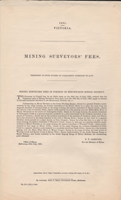
Document - MINING SURVEYORS FEES, 1891
... History House 11 Mackenzie Street Bendigo goldfields GOVERNMENT State Mines Act MINING SURVEYORS FEES - Beechworth Document MINING SURVEYORS FEES ...MINING SURVEYORS FEES - Beechworthgovernment, state, mines act -
 The Beechworth Burke Museum
Photograph, c. 1910
... Beechworth Lunatic Asylum was constructed between 1864-67 designed by The Public Works Department. The hospital is made up of a number of buildings, landscaping, ha-ha, workshops, laundry, administrative facilities and farmland, it was constructed in 'Italianate' style by a team of up to two hundred and fifty workers (Woods p. 122). The asylum was established in response to the need for the regional shire to locally care for those particularly affected by their time working the Ovens goldfield...Beechworth Lunatic Asylum was constructed between 1864-67 designed by The Public Works Department. The hospital is made up of a number of buildings, landscaping, ha-ha, workshops, laundry, administrative facilities and farmland, it was constructed in 'Italianate' style by a team of up to two hundred and fifty workers (Woods p. 122). The asylum was established in response to the need for the regional shire to locally care for those particularly affected by their time working the Ovens goldfield ...Taken approximately 1910, this black and white photograph shows the interior of the surgery and consulting rooms at the Mayday Hills mental hospital known at that time as a lunatic asylum in Beechworth. Mayday Hills Hospital, then known as the Beechworth Lunatic Asylum was constructed between 1864-67 designed by The Public Works Department. The hospital is made up of a number of buildings, landscaping, ha-ha, workshops, laundry, administrative facilities and farmland, it was constructed in 'Italianate' style by a team of up to two hundred and fifty workers (Woods p. 122). The asylum was established in response to the need for the regional shire to locally care for those particularly affected by their time working the Ovens goldfield during the Indigo Shire gold rush era where poor living conditions and isolation were significantly affecting the welfare of a great many people through poverty and lack of resources. The gaol and orphan labour systems were not able to effectively support to give housing, rehabilitation and ongoing care for the mentally ill, and transporting to Melbourne by waggon was a time consuming and counter-productive solution when the metro facilities were already overcrowded. According to Woods (A Titan's Field p. 122), between 1901 and 1911 a large percentage (thirty five percent in 1901 and twenty four in 1911) of the Beechworth population were either patients or inmates of Beechworth institutions, Mayday Hills accounted for some six hundred and seventy four patients in 1901, Beechworth's Mayday Hills was chosen as the site of Victoria's newest asylum, at the time, due to the landscape and altitude. The hilltop atmosphere and the native fauna, it was argued, would assist in the cure of the patients kept at the hospital (Wood 1985, 122). The positioning of the hospital had a beneficial effect on the rural town and the large volume of people living at the hospital and contributing to this population growth is counted as reason for the survival of Beechworth as a regional township. Mayday Hills continued to function as a mental hospital up until 1995 when it was sold to LaTrobe university. The building and grounds are listed on the Victorian Heritage Register under criterion A, B, D, E and F. Although grainy, the image gives a good indication of a functioning interior space of a surgery and consulting room at Mayday Hills in the early 1900's, from which we might interpret (from the types of tools and furniture present), the medical practices being performed at the time.Black and white rectangular photographmedical, asylum, surgery, hospital, beechworth, mayday hills, mayday hills asylum, mayday hills hospital, mental hospital, beechworth lunatic asylum, beechworth institutions, social welfare, public works department, consulting room -
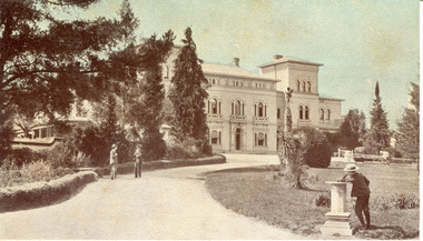 The Beechworth Burke Museum
Photograph - Postcard, George Rose, c. 1910
... Beechworth Lunatic Asylum...photographic postcard...George Rose...The Rose Stereograph co....social welfare...welfare services...Ovens Goldfield...Beechworth Lunatic Asylum was constructed between 1864-67 designed by The Public Works Department. The hospital is made up of a number of buildings, landscaping, ha-ha, workshops, laundry, administrative facilities and farmland, it was constructed in 'Italianate' style by a team of up to two hundred and fifty workers (Woods p. 122). The asylum was established in response to the need for the regional shire to locally care for those particularly affected by their time working the Ovens goldfield...Postcard Rose series Mayday Hills Hospital Mayday Hills Beechworth Lunatic Asylum photographic postcard George Rose The Rose Stereograph co. social welfare welfare services Ovens Goldfield lunatic asylum The Public Works Department Australian landmark Regional shire Indigo Shire Council Gold Rush Beechworth institution Victorian Heritage Register Obverse: Beautiful / Beechworth / (Vic.) / 1800 ft. / above / Sea / Level / - / Asylum / for / insane / (Front / View) / Copyright. / F. / Foxcroft / Photo Reverse: 1997.2454 / Postcard / THIS / SPACE / MAY / BE / USED / FOR / CORRESPONDENCE: / THIS / SPACE / FOR / NAME / AND / ADDRESS / STAMP Rectangular coloured photograph printed as postcard Photograph Postcard George Rose ...Produced c. 1910 by The Rose Stereograph co. This colourised photographic postcard shows the exterior of the administrative buildings at Mayday Hills mental hospital with three young boys in the foreground. This postcard forms part of the extensive Rose Series. (P. 4689) of postcards being produced by the Rose Stereograph co. which depicted landmarks from across Australia. Despite the early date attributed to this image, according to Walsh dates from this series place the postcards being produced typically between 1920-54. Mayday Hills Hospital, then known as the Beechworth Lunatic Asylum was constructed between 1864-67 designed by The Public Works Department. The hospital is made up of a number of buildings, landscaping, ha-ha, workshops, laundry, administrative facilities and farmland, it was constructed in 'Italianate' style by a team of up to two hundred and fifty workers (Woods p. 122). The asylum was established in response to the need for the regional shire to locally care for those particularly affected by their time working the Ovens goldfield during the Indigo Shire gold rush era where poor living conditions and isolation were significantly affecting the welfare of a great many people through poverty and lack of resources. The gaol and orphan labour systems were not able to effectively support to give housing, rehabilitation and ongoing care for the mentally ill, and transporting to Melbourne by waggon was a time consuming and counter-productive solution when the metro facilities were already overcrowded. According to Woods (A Titan's Field p. 122), between 1901 and 1911 a large percentage (thirty five percent in 1901 and twenty four in 1911) of the Beechworth population were either patients or inmates of Beechworth institutions, Mayday Hills accounted for some six hundred and seventy four patients in 1901, Beechworth's Mayday Hills was chosen as the site of Victoria's newest asylum, at the time, due to the landscape and altitude. The hilltop atmosphere and the native fauna, it was argued, would assist in the cure of the patients kept at the hospital (Wood 1985, 122). The positioning of the hospital had a beneficial effect on the rural town and the large volume of people living at the hospital and contributing to this population growth is counted as reason for the survival of Beechworth as a regional township. Mayday Hills continued to function as a mental hospital up until 1995 when it was sold to LaTrobe university. The building and grounds are listed on the Victorian Heritage Register under criterion A, B, D, E and F. Through the colourisation of the photograph and through the unusual choice of the subject matter being used as a postcard, we can get a good indication of aesthetic interests of the time.Rectangular coloured photograph printed as postcardObverse: Beautiful / Beechworth / (Vic.) / 1800 ft. / above / Sea / Level / - / Asylum / for / insane / (Front / View) / Copyright. / F. / Foxcroft / Photo Reverse: 1997.2454 / Postcard / THIS / SPACE / MAY / BE / USED / FOR / CORRESPONDENCE: / THIS / SPACE / FOR / NAME / AND / ADDRESS / STAMPpostcard, rose series, mayday hills hospital, mayday hills, beechworth lunatic asylum, photographic postcard, george rose, the rose stereograph co., social welfare, welfare services, ovens goldfield, lunatic asylum, the public works department, australian landmark, regional shire, indigo shire council, gold rush, beechworth institution, victorian heritage register -
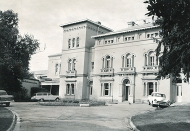 The Beechworth Burke Museum
Photograph - Photographs, E. Yellard, c. 1950's
... Beechworth Lunatic Asylum...Lunatic Asylum...Asylum...Ovens goldfield...Beechworth Lunatic Asylum was constructed between 1864-67 designed by The Public Works Department. The hospital is made up of a number of buildings, landscaping, ha-ha, workshops, laundry, administrative facilities and farmland, it was constructed in 'Italianate' style by a team of up to two hundred and fifty workers (Woods p. 122). The asylum was established in response to the need for the regional shire to locally care for those particularly affected by their time working the Ovens goldfield...Yellard The Public Works Department Public Works Department hospital Mayday Hills Hospital Beechworth Lunatic Asylum Lunatic Asylum Asylum Ovens goldfield Indigo Shire Indigo Shire gold rush 8688.1 reverse: Beechworth / Mental / Hospital / 80% 19cm / 12 cm / 80% / 728 / New / Print / BMM / 8688.1 / E. / Yellard / [Stamped : ILFORD] 8688.2 reverse: Beechworth / Mental / Hospital / E. / Yellard / BMM / 8688.1 / [Stamped : ILFORD] 2 x black and white rectangular photographs [copies] printed on Ilford photographic paper Photograph Photographs E. ...Two rectangular black and white photographs of the Beechworth Mental Hospital (Mayday Hills) administrative building showing the left and right hand sides of the exterior building with three cars parked in driveway turning circle in the foreground taken in the 1950's by E. Yellard. Mayday Hills Hospital, originally known as the Beechworth Lunatic Asylum was constructed between 1864-67 designed by The Public Works Department. The hospital is made up of a number of buildings, landscaping, ha-ha, workshops, laundry, administrative facilities and farmland, it was constructed in 'Italianate' style by a team of up to two hundred and fifty workers (Woods p. 122). The asylum was established in response to the need for the regional shire to locally care for those particularly affected by their time working the Ovens goldfield during the Indigo Shire gold rush era where poor living conditions and isolation were significantly affecting the welfare of a great many people through poverty and lack of resources. The gaol and orphan labour systems were not able to effectively support to give housing, rehabilitation and ongoing care for the mentally ill, and transporting to Melbourne by waggon was a time consuming and counter-productive solution when the metro facilities were already overcrowded. According to Woods (A Titan's Field p. 122), between 1901 and 1911 a large percentage (thirty five percent in 1901 and twenty four in 1911) of the Beechworth population were either patients or inmates of Beechworth institutions, Mayday Hills accounted for some six hundred and seventy four patients in 1901, Beechworth's Mayday Hills was chosen as the site of Victoria's newest asylum, at the time, due to the landscape and altitude. The hilltop atmosphere and the native fauna, it was argued, would assist in the cure of the patients kept at the hospital (Wood 1985, 122). The positioning of the hospital had a beneficial effect on the rural town and the large volume of people living at the hospital and contributing to this population growth is counted as reason for the survival of Beechworth as a regional township. According to the Victorian Heritage database, during the period 1921-1950 Mayday Hills underwent some modernisation by Public Works Department architect Percy Everett which included a nurses' hostel and new ward which were further developed and continued to function as a mental hospital up until 1995 when it was sold to LaTrobe university. The building and grounds are listed on the Victorian Heritage Register under criterion A, B, D, E and F.These photographs give a good indication of the ongoing use of Mayday Hills from its original establishment in the 1860's through to almost one hundred years later when these photographs were taken. The clarity of the images combined with the style and make of the cars in the foreground give a good indication of the time period and show the continued use and need for the facility over the years. Through images of building facades such as these, we might gain fuller understanding of the structural and aesthetic characteristics to be used in any future development or restorative work.2 x black and white rectangular photographs [copies] printed on Ilford photographic paper8688.1 reverse: Beechworth / Mental / Hospital / 80% 19cm / 12 cm / 80% / 728 / New / Print / BMM / 8688.1 / E. / Yellard / [Stamped : ILFORD] 8688.2 reverse: Beechworth / Mental / Hospital / E. / Yellard / BMM / 8688.1 / [Stamped : ILFORD]administrative building, black and white photographs, beechworth, mental hospital, beechworth mental hospital, mayday hills, cars, 1950, e. yellard, the public works department, public works department, hospital, mayday hills hospital, beechworth lunatic asylum, lunatic asylum, asylum, ovens goldfield, indigo shire, indigo shire gold rush -
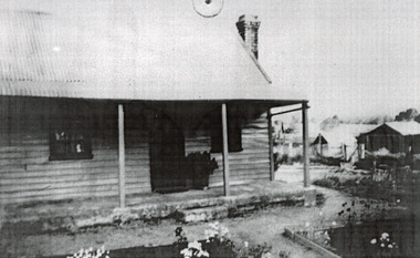 The Beechworth Burke Museum
Photograph, c1900
... Beechworth high-country This photograph shows a small timber house in Wooragee. In 1855, the Ovens district made a shift towards farming development that included the sales of land in the Wooragee Valley. This shift came because of miner's demands and concern about stabilising the area around the goldfield ...This photograph shows a small timber house in Wooragee. In 1855, the Ovens district made a shift towards farming development that included the sales of land in the Wooragee Valley. This shift came because of miner's demands and concern about stabilising the area around the goldfield. Continual migration needed to be supported, unlucky diggers needed alternative employment, and there was a lack of affordable fresh produce available on the goldfields. Initially, the cost of land in areas like Wooragee was prohibitive, and miners chose to squat rather than overpay for poor land. Throughout the 1850s and 1860s, land reform was a key topic for miners and politicians, as they attempted to improve land access and protect financial interests. This photograph is an example of rural development in the Wooragee area, showing the cottage, tents, and garden beds. While the date is unknown, the image nevertheless links us to the 1850s-1860s story of rural development in Indigo Shire. Black and white rectangular photo, copy of original, printed on paper. wooragee, timber, timber cottage, corrugated iron, cottage, housing, tents, gardening, farming, farming and agriculture, construction, garden bed, flowers, verandah, squatting, tent, field -
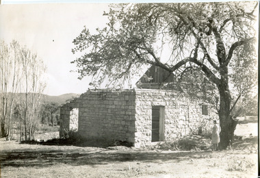 The Beechworth Burke Museum
Photograph, Approximately 1930
... Upon hearing of the vast discovery of gold in Victoria's north-east, he engaged in mining in the Ovens Goldfield district before starting his own dairy on Wooragee road (now Old Wooragee road). The Wooragee Valley, approximately five kilometres north of Beechworth, was used extensively during the nineteenth century to build farming practices in the area, possessing eighteen farms by 1860. ...Beechworth high-country Taken in approximately 1930, this photograph depicts the ruins of Rosehill Dairy. A woman stands beside the ruins, observing them solemnly. The owner of this once prominent dairy, John Brewer, was born in Cornwall, England in 1832. After coming to Australia in 1849, Brewer worked in various forms of livestock transportation. Upon hearing of the vast discovery of gold in Victoria's north-east, he engaged in mining in the Ovens Goldfield ...Taken in approximately 1930, this photograph depicts the ruins of Rosehill Dairy. A woman stands beside the ruins, observing them solemnly. The owner of this once prominent dairy, John Brewer, was born in Cornwall, England in 1832. After coming to Australia in 1849, Brewer worked in various forms of livestock transportation. Upon hearing of the vast discovery of gold in Victoria's north-east, he engaged in mining in the Ovens Goldfield district before starting his own dairy on Wooragee road (now Old Wooragee road). The Wooragee Valley, approximately five kilometres north of Beechworth, was used extensively during the nineteenth century to build farming practices in the area, possessing eighteen farms by 1860. Brewer enjoyed a prosperous career in the dairy industry, personally delivering milk to the residents of Beechworth. He died on the thirteenth of August 1915, a few weeks shy of his eighty-third birthday. As this photograph is dated approximately fifteen years later, it can be assumed that the dairy fell into neglect following his death. This photograph is historically significant as it provides insight the development of the dairy industry in Beechworth in the second half of the nineteenth century.Black and white square photograph printed on matte photographic paper Reverse: 1997.2912 / John Brewers / Rosehill / Dairy / top of the 'rising sun' /john brewer, 1930 beechworth, rosehill dairy, dairy industry beechworh, dairy factories beechworth, dairying, dairy farm beechworth, wooragee road, wooragee valley, old wooragee road, dairy farm ruins -
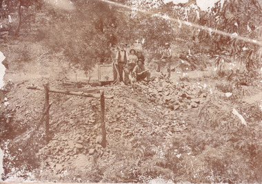 The Beechworth Burke Museum
Photograph
... Beechworth. A large opening to a mine can be seen behind the men in the photograph, with a wheeled cart on a track leading to the men's position, where the soil and rocks have been hauled away. This photograph interestingly contains dogs alongside the miners. While dogs have been recorded as deterrents to thieves in the Victorian goldfields...Beechworth. A large opening to a mine can be seen behind the men in the photograph, with a wheeled cart on a track leading to the men's position, where the soil and rocks have been hauled away. This photograph interestingly contains dogs alongside the miners. While dogs have been recorded as deterrents to thieves in the Victorian goldfields ...This image is a reproduction of an 1899 original depicting the 'Williams Good Luck Mine' on the Mopoke Reef (also called 'Morepork Gully') in the Dingle Ranges, approximately three miles from Beechworth. A large opening to a mine can be seen behind the men in the photograph, with a wheeled cart on a track leading to the men's position, where the soil and rocks have been hauled away. This photograph interestingly contains dogs alongside the miners. While dogs have been recorded as deterrents to thieves in the Victorian goldfields, these dogs appear as companions to these men. Following the discovery of gold at Beechworth in 1852, rushes quickly followed at surrounding creeks and gullies in the district. In the late nineteenth and early twentieth centuries, small syndicates of miners continued to work old or abandoned quartz reefs, often persisting without the assistance of heavy machinery to remove the large amounts of rock, in order to obtain yields at ever greater depths. The group of miners in this photograph are Mr. Roger Williams and Sons, who revived operations at the ‘Old Good Luck’ mine on the Mopoke Reef in the Dingle Range near Beechworth around 1892, working the site for more than two decades. An emigrant from Cornwall with experience in the tin mining industry, 19 year old Roger Williams senior sailed to New Zealand in 1840, then to Australia where he spent time in the Bendigo Gold Fields before settling in Beechworth in the early 1860s. Mr Williams senior worked on various mining activities in the district, including the Rocky Mountain Tunnel project. Conversant with the character of gold-bearing reefs in the area, the syndicate dug an eight hundred foot tunnel, digging down as far down as two hundred feet with little capital save their labour, to connect and provide better working access to the mass of reefs and veins in the vicinity. Progress was hampered by poor air quality charged with fumes from dynamite and large quantities of rock had to be crushed to obtain payable yields. The Victorian Goldfields are filled with ruins and remnants of the area's rich mining history, ranging from small alluvial diggings to the remains of huge mining companies. Site names often changed several times throughout the nineteenth and twentieth centuries. Some sites were abandoned and forgotten, others were worked continuously over many decades. The names of mines were often repeated at different locations throughout the Victorian Goldfields. For example, there is a Mopoke Gully heritage mine near Fryers Creek, Victoria. 'Mopoke' is a common onomatopoeic name for Morepork and Australian Boobook owls.This image has historical, social and research significance for patterns of emigration during of the Victorian Gold Rush, and the historical, social and environmental impacts of mining at Beechworth at the turn of the nineteenth and twentieth centuries. As gold became scarce and government support and large company investment waned, poor hard-working miners laboured intensively to make a living through periods of high unemployment. This image can be compared and studied alongside other historical mining photographs and objects in the Burke Museum Collection. It has potential to improve our understanding of miners working conditions and the shifting character of mining in the Beechworth district.Sepia coloured rectangular photograph printed on gloss photographic paper mounted on card. Obverse: Williams/ Good/ Luck Reverse: A02498/ 1997. 2498/ Good Luck/ Mine/ 1899/ Mopoke. burke museum, beechworth museum, beechworth, gold fields, gold rush, victorian gold rush, gold ming history, colonial australia, australian gold rushes, mining technology, beechworth historic district, indigo gold trail, migration, indigo shire, good luck gold mine, victorian goldfields, mining syndicates, gold fever, quartz-mining, small-scale mining, old good luck mine, mopoke gully, quartz reefs beechworth