Showing 217 items matching "bendigo and districts map"
-
 Bendigo Historical Society Inc.
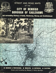
Book - STREET AND ROAD MAPS OF THE CITY OF BENDIGO BOROUGH OF EAGLEHAWK, c1980
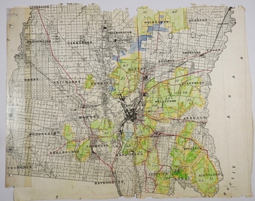
... ...Bendigo and Districts map...Street and Road Maps of the City of Bendigo Borough of Eaglehawk and surrounding Districts of Huntly, Mandurang, Marong and Strathfieldsaye, in color. ...History House 11 Mackenzie Street Bendigo goldfields BOOK Bendigo bendigo & district maps Bendigo and Districts map buildings streetscapes historical pictures advertisements historical information commisioners camp Sandhurst Wesley C Harry Street and Road Maps of the City of Bendigo Borough of Eaglehawk and surrounding Districts of Huntly, Mandurang, Marong and Strathfieldsaye, in color. ...Street and Road Maps of the City of Bendigo Borough of Eaglehawk and surrounding Districts of Huntly, Mandurang, Marong and Strathfieldsaye, in color. Drawn and compiled by Wesley C Harry, Bendigo. Publisher: Cambridge Press, Bendigo. ISBN: 9598608.2.2. 68 pages. Photographs, Illustrations & maps. Photos include: Bendigo buildings, scenery mines, streetscapes, parades, pioneer leaders of Bendigo. Many advertisements throughout. List of Justices of the Peace, hospitals, homes for the aged, schools, churches. Page 58: Copy of ''Freedom of the City to the Australian Survey Regiment'' proclamation, 14th June 1970. Maps cover an area of some 169 sq. miles (43,772 hectares). Origin of the name Bendigo. Information on the five Wards of Bendigo, and their councilors.Wesley C Harrybook, bendigo, bendigo & district maps, bendigo and districts map, buildings, streetscapes, historical pictures, advertisements, historical information, commisioners camp, sandhurst -
 Bendigo Historical Society Inc.
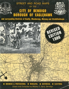
Book - STREET AND ROAD MAPS OF THE CITY OF BENDIGO BOROUGH OF EAGLEHAWK, c1980
... ...Bendigo and Districts map...Street and Road Maps of the City of Bendigo Borough of Eaglehawk and surrounding Districts of Huntly, Mandurang, Marong and Strathfieldsaye, in color. ...History House 11 Mackenzie Street Bendigo goldfields BOOK Bendigo bendigo & district maps Bendigo and Districts map buildings streetscapes historical pictures advertisements historical information commisioners camp Sandhurst Wesley C Harry Street and Road Maps of the City of Bendigo Borough of Eaglehawk and surrounding Districts of Huntly, Mandurang, Marong and Strathfieldsaye, in color. ...Street and Road Maps of the City of Bendigo Borough of Eaglehawk and surrounding Districts of Huntly, Mandurang, Marong and Strathfieldsaye, in color. Drawn and compiled by Wesley C Harry, Bendigo. Publisher: Cambridge Press, Bendigo. ISBN: 9598608.2.2. 68 pages. Photographs, Illustrations & maps. Photos include: Bendigo buildings, scenery mines, streetscapes, parades, pioneer leaders of Bendigo. Many advertisements throughout. List of Justices of the Peace, hospitals, homes for the aged, schools, churches. Page 58: Copy of ''Freedom of the City to the Australian Survey Regiment'' proclamation, 14th June 1970. Maps cover an area of some 169 sq. miles (43,772 hectares). Origin of the name Bendigo. Information on the five Wards of Bendigo, and their councilors. Revised Edition 1986Wesley C Harrybook, bendigo, bendigo & district maps, bendigo and districts map, buildings, streetscapes, historical pictures, advertisements, historical information, commisioners camp, sandhurst -
 Ballarat Tramway Museum
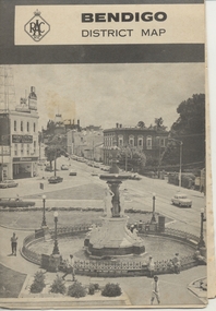
Map, Royal Automobile Club of Victoria, "Bendigo District Map - RACV", c1971
... "Bendigo District Map - RACV"...Printed street map titled "Bendigo District Map", published by the RACV, showing the central part of Bendigo, Bendigo Outlets, streets, principal attractions, Bendigo and district maps and information, and a list of sporting and entertainment facilities. ...Printed street map titled "Bendigo District Map", published by the RACV, showing the central part of Bendigo, Bendigo Outlets, streets, principal attractions, Bendigo and district maps and information, and a list of sporting and entertainment facilities. ...Printed street map titled "Bendigo District Map", published by the RACV, showing the central part of Bendigo, Bendigo Outlets, streets, principal attractions, Bendigo and district maps and information, and a list of sporting and entertainment facilities. Has the tram lines shown dotted, only shows the full extent of the Golden Square line. The main map has the number "0171" in the bottom left hand corner, indicating the publication date.in ink on the Bendigo Outlet map, "3/4" along bottom edge.trams, tramways, map, bendigo, racv, railways -
 Ballarat Tramway Museum
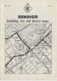
Map, Royal Automobile Club of Victoria, "Bendigo Including city and district maps - RACV", c1968
... Printed street map titled "Bendigo Including city and district maps", published by the RACV, showing the central part of Bendigo on the front cover, Bendigo Outlets and notes on the city itself. ..."Bendigo Including city and district maps - RACV" Map Royal Automobile Club of Victoria ...Printed street map titled "Bendigo Including city and district maps", published by the RACV, showing the central part of Bendigo on the front cover, Bendigo Outlets and notes on the city itself. Has the tram lines shown dotted, only shows the full extent of the Golden Square line. Inside has a district road map. The front cover has the number "0468" in the bottom left hand corner, indicating the publication date.in ink on the Bendigo Outlet map, has various notes showing the location of crossing loops on and off the map and the location of the tram depot itself.trams, tramways, map, bendigo, racv, railways -
 Bendigo Historical Society Inc.
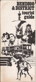
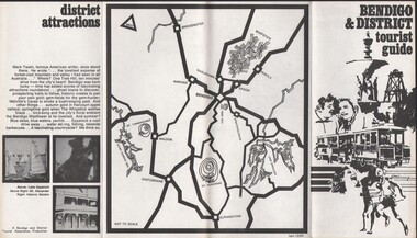
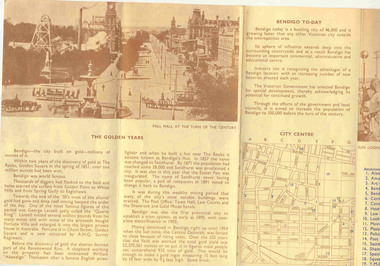
Document - BENDIGO AND DISTRICT TOURIST ASSOCIATION - BENDIGO & DISTRICT TOURIST GUIDE
... Pamphlet produced by the Bendigo and District Tourist Association Bendigo & District tourist guide Pamphlet highlights: historic buildings goldmines art gallery, museums, parks and gardens annual features district attractions city and district map One page , four fold pamphlet...Bendigo and District Tourist Association Bendigo Guide Bendigo and District Tourist Association Pamphlet produced by the Bendigo and District Tourist Association Bendigo & District tourist guide Pamphlet highlights: historic buildings goldmines art gallery, museums, parks and gardens annual features district attractions city and district map One page , four fold pamphlet Document BENDIGO AND DISTRICT TOURIST ASSOCIATION - BENDIGO & DISTRICT TOURIST GUIDE ...Pamphlet produced by the Bendigo and District Tourist Association Bendigo & District tourist guide Pamphlet highlights: historic buildings goldmines art gallery, museums, parks and gardens annual features district attractions city and district map One page , four fold pamphletBendigo and District Tourist Associationbendigo and district tourist association, bendigo guide -
 Bendigo Historical Society Inc.
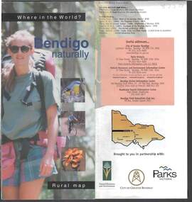
Document - BENDIGO NATURALLY TOURIST BROCHURE
... Parks Vic, Bendigo Greater City publication....History House 11 Mackenzie Street Bendigo goldfields BENDIGO Tourism natural environment District rural map describing topical walks and activities. ...District rural map describing topical walks and activities. Parks Vic, Bendigo Greater City publication.bendigo, tourism, natural environment -
 Bendigo Historical Society Inc.
Document - BROCHURE - BENDIGO & DISTRICT TOURIST GUIDE
... . - c.) of tri-fold (8 pages) Bendigo & District tourist guide, including (1) Historical Buildings, (2) Goldmines; (3) Art gallery, museums, parks and gardens; (4) Annual features; (5) District Attractions; (6)District Map (two pages). ...History House 11 Mackenzie Street Bendigo goldfields ORGANIZATION Government Three copies (a. - c.) of tri-fold (8 pages) Bendigo & District tourist guide, including (1) Historical Buildings, (2) Goldmines; (3) Art gallery, museums, parks and gardens; (4) Annual features; (5) District Attractions; (6)District Map (two pages). ...Three copies (a. - c.) of tri-fold (8 pages) Bendigo & District tourist guide, including (1) Historical Buildings, (2) Goldmines; (3) Art gallery, museums, parks and gardens; (4) Annual features; (5) District Attractions; (6)District Map (two pages). A Bendigo and District Tourist Association Production.organization, government -
 Ballarat Tramway Museum
Pamphlet, The Bendigo and District Tourist Association, "Bendigo & District tourist guide", 1972
... Folded printed pamphlet, four folds, printing in blue and brown ink on fawn paper, titled "Bendigo & District tourist guide", giving a historical outline of the district history and Bendigo today, along with a map of the important tourist features in the CBD area. ...Ballarat Tramway Museum South Gardens Reserve Wendouree Parade Ballarat Ballarat goldfields Trams tramways Bendigo Bendigo Trust Map Folded printed pamphlet, four folds, printing in blue and brown ink on fawn paper, titled "Bendigo & District tourist guide", giving a historical outline of the district history and Bendigo today, along with a map of the important tourist features in the CBD area. ...Folded printed pamphlet, four folds, printing in blue and brown ink on fawn paper, titled "Bendigo & District tourist guide", giving a historical outline of the district history and Bendigo today, along with a map of the important tourist features in the CBD area. On the reverse has a district map showing the location of the various district features. Published by The Bendigo and District Tourist Association in 1972. Three copies held.trams, tramways, bendigo, bendigo trust, map -
 Bendigo Historical Society Inc.
Map - CAMPBELL COLLECTION: BENDIGO AND DISTRICT MAPS
... Map. Bendigo & District. The same as 10104.1. The map is in a very damaged condition....MAP Bendigo allotments Map. Bendigo & District. ...Map. Bendigo & District. The same as 10104.1. The map is in a very damaged condition.map, bendigo, allotments -
 Bendigo Historical Society Inc.
Map - Road maps
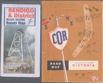
... Two road maps. On, Bendigo & District blue guide handy map the other a road map of Victoria. ...Two road maps. On, Bendigo & District blue guide handy map the other a road map of Victoria. ...BHS CollectionTwo road maps. On, Bendigo & District blue guide handy map the other a road map of Victoria. On the back of the Bendigo map the date October 2000. On the Victoria map the words in pen "This doesn't belong to you, it is mine". L.J. Ellison and a blue stamp of Axedale service station. Aileen and John Ellison Collection.road map, victoria, bendigo -
 Bendigo Historical Society Inc.
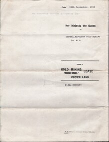
Document - MCCOLL, RANKIN AND STANISTREET COLLECTION: CENTRAL NAPOLEON GOLD MINING CO. N.L, 22nd June 1954
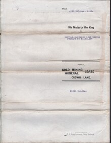
... Document :Form A, Gold Mining Lease Crown Land 11314 Bendigo, Entered in the Register Book, Vol. 333 Fol. 138, Embossed seals of Central Napoleon and King George VI, Map: Mining District of Bendigo County of Bendigo Parish of Sandhurst, During the reign of Queen Elizabeth II, 4 pages....History House 11 Mackenzie Street Bendigo goldfields ORGANIZATION Business industry - mining McColl Rankin & Stanistreet mining gold mining Central Napoleon Document :Form A, Gold Mining Lease Crown Land 11314 Bendigo, Entered in the Register Book, Vol. 333 Fol. 138, Embossed seals of Central Napoleon and King George VI, Map: Mining District of Bendigo County of Bendigo Parish of Sandhurst, During the reign of Queen Elizabeth II, 4 pages. ...Document :Form A, Gold Mining Lease Crown Land 11314 Bendigo, Entered in the Register Book, Vol. 333 Fol. 138, Embossed seals of Central Napoleon and King George VI, Map: Mining District of Bendigo County of Bendigo Parish of Sandhurst, During the reign of Queen Elizabeth II, 4 pages.organization, business, industry - mining, mccoll rankin & stanistreet, mining, gold mining, central napoleon -
 Bendigo Historical Society Inc.
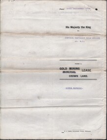
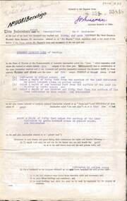
Document - MCCOLL, RANKIN AND STANISTREET COLLECTION COLLECTION: CENTRAL NAPOLEON GOLD MINING CO. N.L, 26th September 1938
... Document: Gold Mining Lease Crown Land No. 10964 Bendigo, Entered in the register books, Vol. 322 Fol. 33571, Embossed seals of Central Napoleon and King George VI, Map: Mining District of Bendigo, County of Bendigo, Parish of Sandhurst, located at Harvey and Inglis Streets, During the reign of King George VI (Originally marked Edward VIII)....History House 11 Mackenzie Street Bendigo goldfields ORGANIZATION Business industry - mining McColl Rankin & Stanistreet mining gold mining Central Napoleoon Document: Gold Mining Lease Crown Land No. 10964 Bendigo, Entered in the register books, Vol. 322 Fol. 33571, Embossed seals of Central Napoleon and King George VI, Map: Mining District of Bendigo, County of Bendigo, Parish of Sandhurst, located at Harvey and Inglis Streets, During the reign of King George VI (Originally marked Edward VIII). ...Document: Gold Mining Lease Crown Land No. 10964 Bendigo, Entered in the register books, Vol. 322 Fol. 33571, Embossed seals of Central Napoleon and King George VI, Map: Mining District of Bendigo, County of Bendigo, Parish of Sandhurst, located at Harvey and Inglis Streets, During the reign of King George VI (Originally marked Edward VIII).organization, business, industry - mining, mccoll rankin & stanistreet, mining, gold mining, central napoleoon -
 Bendigo Historical Society Inc.
Document - MCCOLL, RANKIN AND STANISTREET COLLECTION COLLECTION: CENTRAL NAPOLEON GOLD MINING CO. N.L, 30th October 1939
... Document: Gold Mining Lease crown Land No 11016 Bendigo, Entered in the register book Vol. 324 fol. 35754, Embossed seals of Central Napoleon Gold Mining Co N.L. and Kin g George VI, Map: Mining District of Bendigo, County of Bendigo, Parish of Sandhurst, located at Harvey & Inglis Streets, During the reign of King George VI (document orignally had Edward VIII)....History House 11 Mackenzie Street Bendigo goldfields ORGANIZATION Business industry - mining McColl Rankin & Stanistreet mining Gold mining Central Napoleon Document: Gold Mining Lease crown Land No 11016 Bendigo, Entered in the register book Vol. 324 fol. 35754, Embossed seals of Central Napoleon Gold Mining Co N.L. and Kin g George VI, Map: Mining District of Bendigo, County of Bendigo, Parish of Sandhurst, located at Harvey & Inglis Streets, During the reign of King George VI (document orignally had Edward VIII). ...Document: Gold Mining Lease crown Land No 11016 Bendigo, Entered in the register book Vol. 324 fol. 35754, Embossed seals of Central Napoleon Gold Mining Co N.L. and Kin g George VI, Map: Mining District of Bendigo, County of Bendigo, Parish of Sandhurst, located at Harvey & Inglis Streets, During the reign of King George VI (document orignally had Edward VIII).organization, business, industry - mining, mccoll rankin & stanistreet, mining, gold mining, central napoleon -
 Bendigo Historical Society Inc.
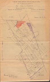
Map - MCCOLL, RANKIN AND STANISTREET COLLECTION: MAP LEASE NO 10423
... On top of map 'plan of area applied for on lease no. 10423, under the mining leases regulations, by John G. Stanfield, mining district of Bendigo. ...On top of map 'plan of area applied for on lease no. 10423, under the mining leases regulations, by John G. Stanfield, mining district of Bendigo. ...Buff coloured map. On top of map 'plan of area applied for on lease no. 10423, under the mining leases regulations, by John G. Stanfield, mining district of Bendigo. Map shows lease coloured in red, see record 2205.821b for letter pertaining to map. Street on map: Rowan St., Shamrock St., Mackenzie Street, Old High St., High Street, Ophir Street, Booth Street.bendigo, business, mccoll, rankin & stanistreet -
 Bendigo Historical Society Inc.
Document - INDENTURE, GOLD MINING LEASE 11081 CROWN AND HERBERT JACKSON LEED OF BENDIGO, MCCOLL, RANKIN AND STANISTREET COLLECTION, 21st September, 1940
... Six page document plus map, dated 21st September 1940, between the Crown and Herbert Jackson Leed, for the land shown on the accompanying map 'indicated by yellow colour' Depths indicated on lease document. On map: Mining District of Bendigo, County of Bendigo, Parish of Sandhurst. ...Major General Sir Winston Joseph Dugan Six page document plus map, dated 21st September 1940, between the Crown and Herbert Jackson Leed, for the land shown on the accompanying map 'indicated by yellow colour' Depths indicated on lease document. On map: Mining District of Bendigo, County of Bendigo, Parish of Sandhurst. ...Six page document plus map, dated 21st September 1940, between the Crown and Herbert Jackson Leed, for the land shown on the accompanying map 'indicated by yellow colour' Depths indicated on lease document. On map: Mining District of Bendigo, County of Bendigo, Parish of Sandhurst. No. 11081. Net Area 24 acres, 3 roods, 3 perches. Signed by Herbert Leed and ?Walsh, Warden Clerk, Bendigo. Map shows lease holding 11081 coloured yellow. Other leases: no's. 9882 11081, 11034, 11080. Streets: Fletcher Street, and Belle Vue Road. Gullies: Derwenters Mistake Bully and Pig Face Gully on lease 11081. Quarry Hill Recreation Reserve marked and some residential allotments. Water race indicated on map. On back of document: ; Deborah United Gold Mining Company No Liability of Charing Cross Bendigo is now the proprietor of the within described estate by transfer registered on 21st November 1940 and numbered 1795202.bendigo, mining, deborah united gold mine, herbert jackson leed, deborah united gold mining. major general sir winston joseph dugan -
 Federation University Historical Collection
Document, Zelda Martin, Central Victorian Goldmining towns - Boom Towns or Ghost Towns?, c1996
... Addresses on behalf of : the people of Bendigo; Members of the Church of England, Bendigo; Members of the Wesleyan Church on the Bendigo Gold Fields; Bendigo Gold District General Hospital; the Bendigo Prospecting Association; Committee of the Bendigo Local Exhibition; Bendigo District Medical Association; Coloured Americans Resident at Bendigo; German Inhabitants of Bendigo; Landowners, Inhabitants, and Miners of Castlemaine; Inhabitants of Forest Creek; Inhabitants of Heathcote and Gold Miners of McIvor; Residents and landholders of the District of Bacchus Marsh; Inhabitants of Kilmore and Vicinity. ...Addresses on behalf of : the people of Bendigo; Members of the Church of England, Bendigo; Members of the Wesleyan Church on the Bendigo Gold Fields; Bendigo Gold District General Hospital; the Bendigo Prospecting Association; Committee of the Bendigo Local Exhibition; Bendigo District Medical Association; Coloured Americans Resident at Bendigo; German Inhabitants of Bendigo; Landowners, Inhabitants, and Miners of Castlemaine; Inhabitants of Forest Creek; Inhabitants of Heathcote and Gold Miners of McIvor; Residents and landholders of the District of Bacchus Marsh; Inhabitants of Kilmore and Vicinity. ...Zelda Martin was a PhD candidate at the University of Melbourne.[.1] 4th item in light blue display book titled Research Approach/Overview of Chapters/Confirmation of Canditure/Chapters1,2,3&4 of proposed thesis. *Twenty-seven page article on Victorian goldfields towns titled: Central Victorian Goldmining Towns - Boom Towns or Ghost Towns. The article was written during the author's PhD study. It outlines the context methodology, and resources and the chapters of the proposed thesis: (1) Central Victorian Goldmining Towns - The Context (2) Contemporary Views of the Factors Necessary for Town Growth (3) Outward Manifestations of Town Growth (4) The Trappings of Government (5-9) The Main Towns and Their Hinterland. [.2] 5th item in Light Blue display book as above item. *Chapter 1 of proposed thesis titled 'Pick, Shovel and Tin Dish Mining.' Covers in Section A: Central Victoria - Pre 1851: Aborigines in Central Victoria, Squatters, and Government. Section B: The years 1851-1854: The Early Gold Rushes, Government Reaction, Township Surveys, Legislation, Town Development, Local Government and Early Settlement. [.3] 6th item in Light Blue display book as above item. *2A of proposed thesis titled 'Contemporary Views of the Factors Necessary for Town Growth'. Similar information to Chapter 1 plus extra re towns and maps. Sections: Introduction, Context of Place - Geographical Towns Listed, The Context of Time - Pre1851 Aborigines, Governance of Port Phillip, The Squatters, The Villages of Central Victorian Highlands, Conclusion, Condensed Version of Chapter2B. [.4] 7th item in Light Blue display book as above item. *Chapter2B of proposed thesis. Sections: Area of Research, Schools, Banks, Newspapers, Progress Association, Town Development - Sandhurst (Bendigo), Ballarat, Castlemaine,, Maryborough, Ararat and Stawell. [.5] 8th item in Light Blue display book as above item. *Chapter 3 of proposed thesis titled 'Outward Manifestations of Town Growth'. Sections: Introduction, Contemporary Writing, Educationalists, The Bankers, The Townsfolk, Current Theory, General Theories of Urban Development, and Conclusion. [.6] 9th item in Light Blue display book as above item. *Chapter 4 of proposed thesis titled 'Trappings of Government' Sections: Introduction, Early Government Attitudes to Mining and Town Development, Law and Order, Township Surveys, Legislation, Local Government, Transport and Communication, The People and Lobbyists. [.7] 10th item in Light Blue display book as above item. *'The Rise and Fall of Central Victorian Goldmining Towns'. Includes a map showing main Goldfields, a table showing towns and villages at two points in time - 1857 and 1871; a Bibliography of Primary and Secondary Sources. [.8] Resource No1. Black display book titled Local Towns 1 : Alma: *Brief history *Directory *Maps Amphitheatre / Mountain Hut: *Brief History Post Office Directory Ararat: *Brief History *Post Office Directory 1869 - Alphabetical Listing by Occupation *Ararat - Prominent Citizens of 1858 *Langi-Morgala Museum Avoca: *Brief History *Excerpts from 'Avoca The Early Years', Margery and Betty Beavis; pg1 - Beginnings; pg11 - The Midas Touch; pg25 - Local Gold Escorts; pg27 - A Town is Born; pg51- The Administration of Justice; pg53 - The Ways of the Law; pg61 - News of the Day; pg65 - A Time to Play; pg72 - Land Ownership *Post Office Directory (Bailliere's) 1869 *Tourism Map and Information of area *Historic Avoca - A 5.5km Tour *Avoca & the Pyrenees Region - information pamphlet Ballarat: *Early History of Ballarat - Ballarat Historical Society, Publication No.1: origin of the name; Ballaarat - the Beginning; Fabulous Yields from the Ballaarat Goldfield; *Streetscape Lydiard Street. *Hand drawn map showing Leigh River, Old Portland Bay Road, plaque on road to Colac; etc. *Newspaper article re 'The Theatre Royal' ( which stood in the vicinity of the current Owen Williams store) - 'The News'15/04/1998 *Article - 'Ballarat's Mechanics' Institute Lives On' Ballarat Courier, 14/09/1985 *Article - Standing the Test of Time' The News 17/11/1993 re The Mechanics Institute & picture of the Reading Room *'Ballarat a Study of a City, Phyllis Reichl, pub. Nelson, 1968; no.3 place, time and people field studies series *Investigator Vol.33 No.2, 1998 Geelong Historical Society. Article on pg75 describes Ballarat in 1861 *Folded poster - 'Ballarat 100' a history of telegraph communication, pub. Telecom. Beaufort (Fiery Creek): *Brief history *Post Office Directory [.9] Resource No.2 Black Folder Titled Towns cont.No2 Bendigo (Sandhurst): *'Family & Local History at the Bendigo Library - 1851-2001 150 years of gold'. *Bendigo Government Camp in 1853 illustration; key to sketch and names of Government officers stationed there *Excerpts from 'Bendigo and Vicinity' Adolph Haman *The Bendigo Goldfield Registry - pgs 1-7 Introduction *Excerpt: 'Breaking the Grip' *Excerpt: The Most Go-Ahead Place *Excerpts from 'History of Bendigo' - anti license agitation; laying out of town; proposed railway; gold calls and dividends; the Sandhurst Municipality; journalism *Bibliography Blackwood: *Excerpts from 'Aspects of Early Blackwood - The Goldfield, the Landmarks, the Pioneers' Alan J Buckingham and Margaret F Hitchcock, JG Publishing,1980 Buninyong: *A Brief History *Investigator Vol1 No.2 Feb 1966 Geelong Historical Society. Pg3 - Article re gold escort route - Mt Alexander to Adelaide - (see a simple monument on the Western Highway a few miles out of Horsham. Pg 15 - Ballarat Excursion - re the finding of gold. *Three articles published by Buninyong and District Historical Society Inc: (Magpie Exploration; Finding Gold In The Green Hills; Magpie Exploration; Burnt Bridge to Cargarie to Mt Mercer) *Copies of newspaper articles/items *Buninyong Street Directory Carisbrook: *In the Beginning There Was Carisbrook *The History of the Carisbrook Racecourse Carngham / Snake Valley: *Brief History *Directory Castlemaine: *Directory 1865-1866 - Alphabetical and Street *Poster - Castlemaine A Contemporary Guide "The Great Centre" 1866 - A Contemporary Guide to the Fascinating Past *Pamphlet - Castlemaine District Community Hospital *Map - Castlemaine, Maldon & Surrounding Districts *Map and Information - The Dry Diggings Track - a 55kl walk among historic goldfields relics ( Castlemaine Fryerstown Vaughan Mt Franklin Hepburn Daylesford) *Postcard - Former Court House *Directory 1867 - Alphabetical, Trade [.10] Resource No.3 Grey folder Titled Towns 3 Creswick to Maryborough Creswick: *Brief History *Booklet - "Creswick Cemetery Walk" *Booklet - The Buried Rivers of Gold Heritage Trail Creswick *Creswick Historical Museum Information Sheet *Chronological History of Creswick *Alphabetical Directory of the Borough of Creswick *Creswick's Creek Directory 1856 *Historic Creswick Walking Tour *A Brief Account of the Schools of Creswick - Past and Present *100 Years of Railway Travel in Creswick *The Berry Deep Leads *The Spence Home at Jackass Gully in the Creswick State Forest ( William Guthrie Spence - Pioneer) *The New Australian Mine and the 1882 Disaster *Creswick District News, Issue 7, July August 1999 *The Creswick Miners Walk - Information and Map *Maps Chewton: *Brief History *Directory Clunes: *Brief History *Clunes Street Directory Daylesford: *Brief History *Notable Bushfires in Daylesford District Over More Than a Century - "Black Thursday" 1851; 1862; 1899; the Disastrous Hepburn Fire of 1906; 1939; 1944; 1969. *Post Office Directory -Daylesford and Hepburn Dunolly / Inkerman: *Brief History *Directory *Pamphlet - Goldfields Historical Museum *Pamphlet - Historic Dunolly - Victoria's Best Kept Secret *Map of Gold Workings at Dunolly Area - showing where the main gold rushes occurred *Brief History - Inglewood *Directory - Inglewood - Name Occupation, Dwelling Kingower: *Brief History *Directory - Name / Ocupation / Dwelling Linton / Happy Valley / Piggoreet: *Brief History *Directory - Lintons McIvor: *"A History of the Shire and the Township of Heathcote" by J.O. Randell Majorca: *Brief History *Official Post Office Directory 1869 - Name / Occupation/ Address Maldon (Tarrangower): *Brief History Part 1 *Brief History Part 2 *Post Office Directory *List - Alphabetical Order by Names plus Business and Trade (Tarrangower Times Oct/1858) *List - Alphabetical Order by Trade plus Name and Business *Directory - Name / Occupation / Dwelling Maryborough: *Worsley Cottage - built by Arthur Worsley, a contractor in stonework in 1894 [.11] Resource No. 4 Blue Display Book titled Towns 4 Moliagul to Stawell Moliagul: *Brief History *Moligul Legislative Assembly (Voting?) List - Names and Occupations *Moliagul Victorian Post Office Directory 1868 - Name / Ocupation / Address / Comments *"The Welcome Stranger" gold nugget *The Sunday School *The Welcome Stranger Discovery Walk - information and map Moonambel (Mountain Creek) Redbank *Brief History *List of names extracted from advertisments of the Pioneer and Mountain Creek Advertiser 16/02/1861. *Bailliere's Directory 1869 - Alphabetical List of Name / Occupation / Place St Arnaud: *Brief History Sebastapol: *Brief History *Directory 1869 - Alphabetical by Name; plus occupation and address. Browns and Scarsdale: *Brief History *Browns Street Directory - Name and Occupation Smythesdale: *Brief Description *Smythesdale Street Directory -Name and Occupation Stawell (Pleasant Creek) *Brief History *Victorian Official Post Office Directory - Name /Occupation / Dwelling *Chronology - 1841-1920 *Production of gold statistics - 1879 - 1900 *Big Hill *Extracts from "The Golden Years of Stawell". Chapt 1 - Stawell's Coming Out. Capt. 2 - The Gold Rush. Caapt.3 - Cradle of Democracy. Chapt.4 - The Reefs Becomes Stawell. Chapt. 5 - Rushing In. Chapt.6 - The Pioneers. Chapt 7 - The Decade of Optimism. [.12] Resource No. 5: Blue Display Book titled 'Towns Steiglitz to the The Golden Triangle. Steiglitz: Brief History Victorian Post Office Directory 1869 *Map of Steiglitz *List of maps relevant to Steiglitz history *Information 6 tables of data from "Reports of Mining Surveyors Talbot (Back Creek) Brief History Taradale: Post office Directory 1869 - Name/Occupation/Street. Also list in alphabetical order by Occupation Taradale *Chronological Reference to Taradale Mines *Water - The Coliban System of Waterworks *Joseph Brady *The Syphon Tarnagulla (Sandy Creek) *Brief History *Tarnagulla Businessmen Cameos to give depth to advertisments in 'The Tarnagulla Courier' various issues 1864-1871 *Directory - Name/Occupation /Address *List - Name/Business/Trade Wedderburn (Koorong) *Brief History *List - Name/Occupation The Golden Triangle: *The Early Rushes - Wedderburn / Moliagul / Sandy Creek - Tarnagulla / Jones Creek - Waanyarra / Kingower / Dunolly - Goldsborough / Inglweood *Census of 1857 - Population / Occupations *1858-1871 - A Time of Consolidation- Wedderburn / Moliagul / Sandy Creek- Tarnagulla / Arnold *Census 1871 - Population *Information gleaned from the census data - Demographics / Population / Occupations / marital / Birthplace / Religion / Literacy/ Occupation and Housing Cameos *Graphs - Birthplace of settlers /Male-Female Ratio / Married males / Children under 15 as Percentage of Population / Religion *Census 1857 - Statistical data *Maps *Bibliography [.13] Resource No. 6 - Black Display Book Information and Research in Central Victoria including: *Banking - Research from ANZ Bank Archives *Institutions - also includes articles listed from the Ballarat Times Newspaper *Australian mining History Association - A.M.H.A. Bibliography *Australia's Mining History * Bibliography - Land Surveys Victoria - *1853 Administration (Statistics and Other) includes: schools / ministers of religion / police / military / local administration / licences for sale of spirits / distances between various Victorian gold fields. * Victoria Government Gazette (Copy) - N0. 116, 12/12/1854 includes: Gold Felds Commission of Enquiry & No. 85, 15/09/1854 - Addresses presented to the Lieutenant Governor (Sir Charles Hotham) during his tour through the Gold Fields of Victoria,1854. Addresses on behalf of : the people of Bendigo; Members of the Church of England, Bendigo; Members of the Wesleyan Church on the Bendigo Gold Fields; Bendigo Gold District General Hospital; the Bendigo Prospecting Association; Committee of the Bendigo Local Exhibition; Bendigo District Medical Association; Coloured Americans Resident at Bendigo; German Inhabitants of Bendigo; Landowners, Inhabitants, and Miners of Castlemaine; Inhabitants of Forest Creek; Inhabitants of Heathcote and Gold Miners of McIvor; Residents and landholders of the District of Bacchus Marsh; Inhabitants of Kilmore and Vicinity. *Gold Fields Correspondence 1853: letter from Lieutenant Colonel Valiant, (Officer commanding the Troops in Victoria) to the Lieutenant Governor re threatened disturbance at Sandhurst (Bendigo) regarding the Gold License Fee. * Extracts from a book "Victoria" re Gold Fields Commission of Enquiry involving mainly Ballarat and Castlemaine and a chapter titled 'A Tour to the Victorian Gold-Fields' *Lists of central Victorian newspapers - listed by date published 1851to 1874; by first date available to State Library. *A list of cities and towns showing County, population in 1861 &1871, and municipal status. [.14] Resource no.7. Black display book. *Reference: Papers presented to Parliament Victoria - 1859-1860 4 volumes - relevant sections copied. Contains information on Branches of Government. General / Finance / Gold / Gazette / Commission and Warrant / Statistic. *Gold Fields Act. In accordance with the Act the gold fields are divided into six districts - Ballaarat, Castlemaine , Sandhurst, Avoca, Ararat, and Beechworth.. Official staff in each gold district consists of a Resident Warden, Wardens, Wardens' Clerks, Bailiffs, Chinese Protectors, Chinese Interpreters, and Mining Surveyors. *Gold Receiver *Gaols *Police magistrates and Clerks of Petty Sessions, etc. *Field Branch *Immigration and Emigration Overland - Chinese - 1859 *Population on the Goldfields *The Geological Survey - The Government Geologist is assisited by staff from four branches - the office Branch; the Publishing Branch; the Field Branch and the Museum Branch. *Commission to Enquire Into Sludge dated 10/02/1859 (Some sections copied) - Report to the Honorable Chief Commissioner of Public Works, Melbourne re the mode of carrying the sludge from the puddling mills in Sandhurst without interfering with the drainage of the town and the roads in the neighbourhood. [.15] Resource No.8: Camel display book titled Resource No. 8. Aborigines *Lists of book titles - +"Readings in Victorian prehistory" +"The Aborigines of Port Phillip" +Aboriginal languages and clans" +"A History of the Port Phillip District" +"Langi Ghiran 1: Aboriginal Rock...." +"Koorie History: sources for aboriginal studies in the State Library of Victoria", ed. Tom Griffiths, Melb. Friends of the State Library, 1989 +"The Public Lands of Australia Felix"; settlement and land appraisal in Victoria1834-91 with special reference to the Western Plains", J.M.Powell, Melb. Oxford University Press 1970 +*Bibliography of the Victorian Aborigines' from the earliest manuscripts to 31st December 1970, Massoa, Aldo, Melb. Hawthorn Press, 1971 +"Aborigines in Colonial Victoria, 1836-1886", M.F. Christie, Sydney University Press, 1979 +"Urban and Industrial Australia: readings in Human Geography" ed J.M. Powell, Melb. Sorrett Pub. 1974 *Extracts: -Processes of Pioneer Settlement - The Squatting Occupation of Victoria, 1834-60. J.M. Powell -Areal Variations in the Class Structure of the Central-Place Hierarchy. P. Scott - Volume1 and Volume 2: Notes Relating to the Habits of the Natives of Other Parts of Australia and Tasmania. Compiled from various sources for the Government of Victoria by R Brough Smyth. John Curry, O'Neil, Melb. 1st pub. Melb. 1876. p31-45 - Numbers and Distribution of the Aborigines in Victoria -Victorian Aborigines 1835-1901 - A Resource Guide to the Holdings of the Public Record Office, Victoria; published by the Government Information Centre 1984. *History of the Aboriginal Artefacts Displayed in the Daylesford Museum. F. G. Powell (4 page pamphlet) *Letter to Zelda Martin from Peter Lovett, Cultural Officer, Ballarat & District Aboriginal Co- Operative, 05/02/1997 *Map: Ian Clarke Victorian Tribunal Boundary Map - Clans of Central Victoria. *Victorian Rock Art and Mythology - Article about Mount Langhi Ghiran and myths of the Tjapwarong people. *Two Aboriginal myths relating to the Grampians - 'The Monster Emu' / 'The Aquisition of Fire', by the Aborigines in the Grampians Areas *Article titled (chapter 8) Ballarat - information re camping sites in the region. Lake Wendouree / Lake Burrumbeet (includes a myth) / Mt Bunninyong / Lal Lal / Pitfield / Mount Elephant / Mount Egerton / Meredith / Lake Goldsmith / Lake Learmonth / Ercildoune *Notes on the Aborigines of the Wider Ballarat Region plus European names=Aboriginal names. John Morris 26/07/1995 *Role of Aborigines in Town Development in Central Victoria. Mentions Native Police Force est. in Port Phillip 1842 and Central Board for Aborigines est. 1860 *The Grave of King Billy. (Frank Wilson) Pamphlet. *Camping Places in Central and Northern Victoria. Article re Lake Burrumbeet site. *Programme for the Unveiling of Memorial Cairn for Edward Stone Parker 1802-1865. Note portrait not accurate. Accurate portrait is available in the book "A Successful Failure A Trilogy The Aborigines and Early Settlers", Edgar Morrison, Graffiti Publications, 2002. * Large envelope addressed to Mr G Netherway containing newspaper cuttings regarding the life of Edward Stone Parker, the unveiling of the Memorial Cairn as mentioned above, articles titled 'Episodes from Our Early Days' (Edgar Morrison, Yandoit)- The Black's School, A School At Last and The Final years. Also a typed page titled 'Historical Background to E.S.Parker's Career. Includes an interesting tale titled 'When the cat lay doggo' re laying power leads for the unveiling ceremony at the memorial site. [.16] green display folder titled 'Research Aids' *List of references to Commissioners' & W'ardens' Reports (formerly held at La Trobe Library Archives, now at Public Records Office [PRO]). Indicates town referred to / date of report / name of camp if different to town. * Archive information re Anglican Records *Movement around the Goldfields - Miners and Storekeepers - usefulness of newspapers in providing information - areas covered - Castlemaine, Maldon, Ararat, Stawell, Tarnagulla, Dunolly. *Port Phillip /Victoria Directories 1839/1867 - Chronological list of Directories included in this series. *"Notes on the History of Local Government in Victoria" A.W. Greig Melb. University Press 1925 - Photo-copied extract p5-p40. (Source - Deakin University Library) - Introduction by W.Harrison Moore. Section 1 - Development in New South Wales Before Separation. Section 2 - Development in Victoria After Its Separation from New South Wales. Hand written notations: 'roads, markets, and local government 1855 on' ;'opportunity of squatters in parliament' and 'opportunities of matters in parliament p33' * Notes on the Establishment of Surveyor General's Department 1851and Commissioner of Crown Lands and Survey. * Newspaper articles from The Argus, 1849, re the discovery of gold in the Pyrenees region. * Excerpt - a report on schools - A.B.Orlebar, Inspector; re the need for permanent school buildings rather than tents. *Excerpt from - 'Approaches to Urban History', Sean Glynn: The Case for Caution * Except from - 'The Urban Sprinkle', Weston Bate: Country Towns and Australian Regional History *Reference- 'The History of Land Tenure in the Colony of Victoria', John Quick. References the Haines Land Bill, land tenure and Land Leagues. [.17] Light blue envelope folder titled 'Birtchnell's Ballarat, etc. Directory 1862 *Contains various directories for Smythesdale, Buninyong, Clunes, Brown's and Creswick. [.18] Red envelope folder no.2 titled Victorian Gazetteer *Selected pages from 1869 Victorian Gazetteer on A4 paper (with a handwritten note questioning if some pages are from 1868 Victorian Gazetteer as appears to be different sizes - A3 pages.) Information includes locations and descriptions of towns, hotels, banks, communications and populations. (Does not include names, residences and occupations) [.19] Red Envelope folder titled Bailliere's Official Post Office Directory 1868 (or1869 or a mixture of both?) *Preface *Contains a selection of pages of towns highlighted in yellow in the the index *Work on this directory was commenced in 1867. *Information includes: Municipalities - mayors and councilors; lists of towns naming male inhabitants and their occupations. [.20]Yellow manila folder titled Post Grad Seminar Presentation 1996 *Gives some background to Zelda Martin's proposed thesis and why she chose the topic Gold Mining Towns Boom or Bust [.21] A3 display book - No. 1A * A list of 'Relevant Newspapers collected: The Tarrangower Times and Maldon Advertiser (first published 1858) Includes dates 1858-1867. The Mount Alexander Mail. Includes dates 1854-1866 The Tarnagulla Courier. Includes dates from1864-1871 Dunolly and Burnt Creek Express. Includes dates from 1862-1871 * Selection of newspaper pages from The Mount Alexander Mail 1854 to 1856, mostly showing advertisements for businesses and services provided to that community. [.22] A3 display book - No. 1B * Selection of newspaper pages from The Mount Alexander Mail 1857 to 1866, mostly showing advertisements for businesses and services provided to that community. [.23] A3 display book -No. 2 * Selection of newspaper pages from The Tarnagulla Courier 1864 to 1871, mostly showing advertisements for businesses and services provided to that community. [.24] A3 display book - No. 3 *Selection of newspaper pages from The Tarrangower Times (and Maldon and Newstead) Advertiser 1858 to1867, mostly showing advertisements for businesses and services provided to that community. [.25] A3 display book - No.4 * Selection of newspaper pages from The Dunolly and Burnt Creek Express; and The Dunolly and Betbetshire Express 1862 to 1871, mostly showing advertisements for businesses and services provided for that community. [.26] A3 display book - No.5 Includes: * Bryce Ross's Diggings Directory. Includes instructions for using this directory. This directory was used by "all persons having connexion or desiring to communicate with 'working parties, private friends, or Stores at the Diggings." As a directory for each area wwas completed it was published in each month's issue of Bonwick's "Digger's Magazine." Years c1852/1853. This Directory commences first at the head of Forest Creek. Includes a directory for Bendigo and Ballarat. Of interest at the end of the Bendigo and Ballarat directory is a list of the number of storekeepers, butchers, doctors, smiths, eating houses, lemonade sellers and chapels. * The Castlemaine Directory and Book of General Information Comprehending Glass's Model Calendar for the Two Years 1862 and1863. "zelda martin, victorian goldfield towns, bendigo, castlemaine, ballarat, maldon, stawell, ararat, maryborough, creswick, avoca, heathcote, banks, bank of australasia, union bank of australia, government camp, sandhurst, water supply, tarnagulla, talbot, back creek, mountain creek, police court, carisbrook, dunolly, thompson's foundry, charles clacy, anthony trollope, robert cecil, mount alexander, urbanisation, national schools, education, govenrment, industry, railway, transport, settlement, land settlement in central victoria, steiglitz, joseph brady, the new australian mine, berry deep leads, william guthrie spence, creswick state forest, arthur worsley, worsley cottage, the welcome stranger, moliagul, moonambel, redbank, st arnaud, sebastapol, brown's, scarsdale, clunes, chewton, daylesford, bushfires, inkerman, inglewood, kingower, lintons, happy valley, piggoreet, mcivor, majorca, tarrangower, taradale, the coliban system, the syphon, sandy creek, wedderburn, koorong, arnold, jones creek, waanyarra, the golden triangle, census 1857, blackwood, buninyong, durham lead, magpie, carngham, snake valley, alma, amherst, daisy hill, amphitheatre, mountain hut, beaufort, fiery creek, counties, population, gold fields commission of enquiry1854, william westgarth, gold license fee, lieutenant colonel valiant, administration of the victorian gold fields, commission to enquire into sludge 1859, e.s. parker, edward stone parker, edgar morrison, mount franklin protectorate, dja dja wurrung, memorial cairn, franklinford, mt franklin memorial cairn, jajowurrong, dja dja wurung, tjaowarong, wothowurong, assistant protectors, daylesford museum, buluk, rock art - grampians, aboriginal mythology - grampians, aborigines, first nations people, mount franklin, aboriginal artifacts, lake burrumbeet, native police force, central board of aborigines, yandoit, commissioners' reports, wardens' reports, port phillip/victoria directories 1839-1867, local government - victoria 1853/1854, surveyor general's department - 1850's, victorian schools 1850's, a.b.orlebar, haines land bill, william charles haines, wilson gray, land tenure, land leagues, victorian gazetteer, the tarrangower times and maldon advertiser - 1858-1867, the mount alexander mail 1854-1866, the tarnagulla courier 1864, dunolly and burnt creek express 1862-1871, bryce rose's diggings directory, the castlemaine directory 1862-1863 -
 Bendigo Military Museum
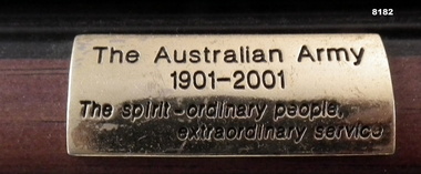
Painting - AUSTRALIAN ARMY 100 YEARS, Post 2001
... Bendigo Military Museum 37 - 39 Pall Mall Bendigo goldfields As the plaque states it is a depiction of the Australian Army over a 100 year period from 1901 - 2001. ...As the plaque states it is a depiction of the Australian Army over a 100 year period from 1901 - 2001. This item is on display in the Bendigo District RSL Havilah Road..Framed images of the Australian Army over 100 years, frame is brown timber with a gold edge, background is green with a Rising Sun center top, in top LH corner is the Australian flag, central is a intermixed depiction taken from photos of the history of the Australian Army with a larger colour depiction of a modern soldier to go with the time 2001.Under this is a oval shape with a map of the World centre on each side of the map is 3 rows of campaign ribbons from 1901 -2001. At the bottom on the frame is a small plaque with text in Black.On the plaque,, “The Australian Army 1901 - 2001 - The Spirit - Ordinary people, extraordinary service”brsl, smirsl, bdrslinc -
 Bendigo Military Museum
Photograph - Print Troop Equipment, Lithographic Squadron – Army Survey Regiment, Fortuna, Bendigo, c1990s
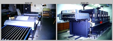
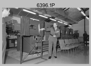
... map was printed in a single pass. The print room housing the Speedmaster printing press was named Wayzgoose Hall after a medieval printing house festival. Wayzgoose Hall and the Speedmaster printing capability was commissioned by the Commander of the 3rd Military District BRIG P. ...Bendigo Military Museum 37 - 39 Pall Mall Bendigo goldfields This is a set of 25 photograph of Print Troop Equipment in Lithographic Squadron, Army Survey Regiment at Fortuna, Bendigo, 1990. ...This is a set of 25 photograph of Print Troop Equipment in Lithographic Squadron, Army Survey Regiment at Fortuna, Bendigo, 1990. Photo .1P features the new Howson Algraphy Autoneg printing plate processor. It improved quality control and efficiency and allowed the conversion of printing plates for positive or negative use. The Heidelberg Speedmaster 102 shown in photos .2P to .4P was a computer-controlled five colour lithographic offset printing press. It provided the Royal Australian Survey Corps a vastly improved printing capability, as the five colours for a standard topographic map was printed in a single pass. The print room housing the Speedmaster printing press was named Wayzgoose Hall after a medieval printing house festival. Wayzgoose Hall and the Speedmaster printing capability was commissioned by the Commander of the 3rd Military District BRIG P. Davies AM, ADC on Wednesday 27th June 1990. This occasion is covered in more detail in page 145 of Valerie Lovejoy’s book 'Mapmakers of Fortuna – A history of the Army Survey Regiment’ ISBN: 0-646-42120-4. For additional photos, refer to item 6062.4P for more photos of the Heidelberg Speedmaster printing press. The Print Room’s Map Assessment and Colour Evaluation Stations in photos .5P to .12P provided the Printer Technician suitable viewing environments to perform quality assessments of map samples. See item 6151.35P for more information and photos of technicians using the equipment. The Print Room’s Map Handling Station in photo .15P to .20P provided ergonomic benefits to the Printer Technician and improved despatching productivity. See Item 6070.9P for more information and photos. The Wohlenberg MCS-2 guillotine seen in photos .21P & .22P was a heavy-duty guillotine integrated component of the Map Handling Station, to trim bulk printed map stock. See item 6069.6P for more information and photos of earlier types of guillotine equipment. This is a set of 25 photograph of Print Troop Equipment in Lithographic Squadron, Army Survey Regiment at Fortuna, Bendigo, 1990. The photographs are on 35mm colour slides and were scanned at 96 dpi. They are part of the Army Survey Regiment’s Collection. .1) - Photo, colour, c1990s, Howson Algraphy Autoneg printing plate processor .2) to .4) - Photo, colour, 1990. Heidelberg Speedmaster 102 computer-controlled five colour lithographic offset printing press .3) to .10) - Photo, colour, c1990s, Heidelberg Speedmaster CPC 1-04 control unit. .11) to .12) - Photo, colour, c1990s, Map Colour Evaluation Work Station. .13) to .14) - Photo, colour, c1990s, Linear printing plate registration punch. .15) to .20) - Photo, colour, c1990s, Print Room’s Map Handling Station. .21) to .22) - Photo, colour, c1990s, Wohlenberg MCS-2 guillotine. .23) - Photo, colour, c1990s, Print Room Power supply equipment. .24) to .25P - Photo, colour, c1990s, Print Room Crown Fork Lift..1P to .25P - There are no annotations stored with the 35mm slides.royal australian survey corps, rasvy, army survey regiment, army svy regt, fortuna, asr, printing, litho -
 Bendigo Military Museum
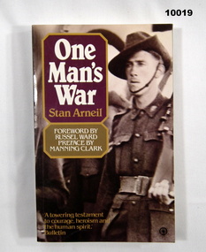
Book - PERSONAL NARATIVE, WW2, S.F. ARNEIL, "ONE MAN'S WAR", 1982
... "An Orientation" page - black ink stamp - "BENDIGO DISTRICT/ RSL SUB BRANCH INC/ P.O. BOX 449/ BENDIGO, VIC, 3550" Soft cover book. ...Soft cover book. Cover- cardboard, brown and black colour background. White, gold and black print on front, spine and back. Illustrated, front sepia photograph of a soldier holding a rifle in his left hand. 288 pages - cut, plain, white colour paper. Illustrated black and white photographs, documents and maps. Front end paper - white colour adhesive label. Title page - handwritten information. "An Orientation" page - ink ownership stamp. Adhesive label information - black ink print - "From Bishop Noel Daly's Collection 2004" Handwritten information - blue ink stamp "Sister M. Seagrave". "An Orientation" page - black ink stamp - "BENDIGO DISTRICT/ RSL SUB BRANCH INC/ P.O. BOX 449/ BENDIGO, VIC, 3550"publications, books, biography, ww2 -
 Bendigo Military Museum
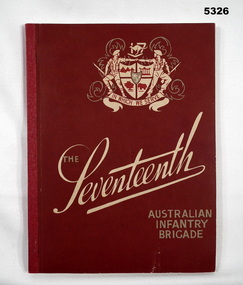
Book, The Seventeenth Brigade Magazine, 'THE SEVENTEENTH AUSTRALIAN INFANTRY BRIGADE
... Crosbie" - Owner's stamp, black ink BENDIGO DISTRICT/ RSL SUB BRANCH INC/ PO BOX 449/ BENDIGO VIC 3552. ...Book - "Issued to mark the fourth Anniversary of the departure from Australia of the 17th Australia Infantry Brigade for Active Service".Soft cover book. Soft cover, cardboard. Gold and cream print on front cover. Burgundy coloured background. Front cover illustration -0 military coat of arms with the words 'IN WHICH WE SERVE" . 144 pages, paper, cut, plain, off white. Illustrated black & white photographs, maps and illustrations. Book binding cloth tape on spine and stapled. Inscriptions - two on title page.Title page - handwritten, black ink " Estate/Mrs J. Crosbie" - Owner's stamp, black ink BENDIGO DISTRICT/ RSL SUB BRANCH INC/ PO BOX 449/ BENDIGO VIC 3552.books, history, ww2, 1939-1944 -
 Bendigo Military Museum
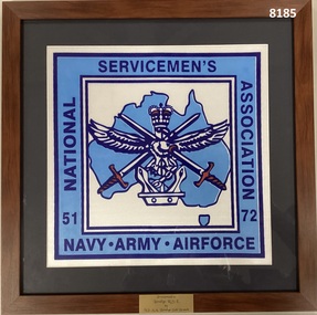
Print - NSAA LOGO FRAMED, unknown
... Bendigo Military Museum 37 - 39 Pall Mall Bendigo goldfields The Bendigo Branch of the National Servicemen's Association was established Post 2000 and held their meetings at the Bendigo District RSL Sub Branch Havilah Rd. brsl smirsl NSAA On the small brass plaque, "Presented to Bendigo RSL by NSAA Bendigo Sub Branch" National Servicemen's Association Logo framed, square shape, blue and white colours with central map of Australia with crossed swords over with crown, eagle and anchor representing Navy, Army and Airforce. ...The Bendigo Branch of the National Servicemen's Association was established Post 2000 and held their meetings at the Bendigo District RSL Sub Branch Havilah Rd.National Servicemen's Association Logo framed, square shape, blue and white colours with central map of Australia with crossed swords over with crown, eagle and anchor representing Navy, Army and Airforce. The frame has a brass inscribed plaque at the bottom.On the small brass plaque, "Presented to Bendigo RSL by NSAA Bendigo Sub Branch"brsl, smirsl, nsaa, -
 Bendigo Military Museum
Photograph - Wayzgoose Hall and Speedmaster Printing Press Commissioning, Army Survey Regiment, Fortuna Villa, Bendigo, 1990
... Davies AM ADC, Bruce Reid Bendigo MHR....Bendigo Military Museum 37 - 39 Pall Mall Bendigo goldfields The first photograph was probably taken at a media event announcing the introduction of the Heidelberg Speedmaster printing press in late 1990. ...The first photograph was probably taken at a media event announcing the introduction of the Heidelberg Speedmaster printing press in late 1990. LTCOL Rene van den Tol was the CO of the Army Survey Regiment from 1989 to 1991. Partly obscured behind the CO was Mr Bruce Reid, who was the newly elected federal member for Bendigo. The media event was held in Wayzgoose Hall, Lithographic Squadron’s new purpose-built building constructed to house the Speedmaster printing press. This occasion is covered in more detail in page 143 of Valerie Lovejoy’s book 'Mapmakers of Fortuna – A history of the Army Survey Regiment’ ISBN: 0-646-42120-4. Refer to Item 6291.6P for more photos of the Open Day.This set of three photographs were taken at the commissioning ceremony of Wayzgoose Hall, the Army Survey Regiment’s new printing building and the Heidelberg Speedmaster Printing Press, at Fortuna Bendigo on Wednesday 27th June 1990. The black & white photographs were printed on photographic paper and are part of the Army Survey Regiment’s Collection. The photographs were scanned at 300 dpi. .1) - Photo, black & white, 1990. Commissioning Ceremony L to R: CO LTCOL Rene van den Tol, Commander 3rd Military District BRIG P. Davies AM ADC, WO2 Jeff Willey in background. .2) - Photo, black & white, 1990. L to R: CO LTCOL Rene van den Tol, Commander 3rd Military District BRIG P. Davies AM ADC with first printed topographic map – 8123 4 Mansfield 1:50 000. .3) - Photo, black & white, 1990. L to R: SGT Gary Kerr in background, Seligson Claire Printing Press Suppliers - Richard Rasmussen and Oliver Holliwell, Bob Martin, Director of Survey COL Don Swiney MBE, RA Svy COL CMDT COL John Hillier, Commander 3rd Military District BRIG P. Davies AM ADC, Bruce Reid Bendigo MHR..1P to .3P – Annotated on back of photos ‘Opening New Print Room BRIG Davies 27 Jun 90’. Personnel and civilians are identified.royal australian survey corps, rasvy, army survey regiment, army svy regt, fortuna, asr, litho -
 Bendigo Military Museum
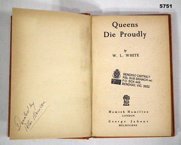
Book - BOOK, FLYING FORTRESS WW2, W. L. WHITE, "Queens Die Proudly", 1944
... Bendigo Military Museum 37 - 39 Pall Mall Bendigo goldfields Book - account of the Flying Fortresses in the South West Pacific War WW2, Books Mikitary History WW2 Flying Fortresses Front end paper and Title page - black ink owner's stamp - "BENDIGO DISTRICT/ RSL SUB BRANCH INC/ PO BOX 449/ BENDIGO, VIC, 3552. ...Book - account of the Flying Fortresses in the South West Pacific War WW2,Hard Cover book. Cover - cardboard, orange colour paper with black print on spine. 223 pages - cut, plain, off white paper. End papers - Illustrated, black and white map South-West Pacific. Front end paper and Title page - owner's stamp.Front end paper and Title page - black ink owner's stamp - "BENDIGO DISTRICT/ RSL SUB BRANCH INC/ PO BOX 449/ BENDIGO, VIC, 3552. Opposite Title page - handwritten black ink - "Donated by/ Peter Morrison".books, mikitary history, ww2, flying fortresses -
 Bendigo Military Museum
Photograph - New Printing Press, Lithographic Squadron – Army Survey Regiment, Fortuna, Bendigo, 1990
... This is a set of 30 photographs of contractors installing the Army Survey Regiment’s new Heidelberg Speedmaster 102 printing press in Lithographic Squadron’s purpose-built printing building at Fortuna, Bendigo in 1990. The computer-controlled five colour lithographic offset printing press provided the Royal Australian Survey Corps vastly improved printing capability, as the five colours for a standard topographic map was printed in a single pass. ...Bendigo Military Museum 37 - 39 Pall Mall Bendigo goldfields This is a set of 30 photographs of contractors installing the Army Survey Regiment’s new Heidelberg Speedmaster 102 printing press in Lithographic Squadron’s purpose-built printing building at Fortuna, Bendigo in 1990. ...This is a set of 30 photographs of contractors installing the Army Survey Regiment’s new Heidelberg Speedmaster 102 printing press in Lithographic Squadron’s purpose-built printing building at Fortuna, Bendigo in 1990. The computer-controlled five colour lithographic offset printing press provided the Royal Australian Survey Corps vastly improved printing capability, as the five colours for a standard topographic map was printed in a single pass. The print room was named Wayzgoose Hall after a medieval printing house festival. Wayzgoose Hall and the Speedmaster printing capability was commissioned by the Commander of the 3rd Military District BRIG P. Davies AM, ADC on Wednesday 27th June 1990. This occasion is covered in more detail in page 145 of Valerie Lovejoy’s book 'Mapmakers of Fortuna – A history of the Army Survey Regiment’ ISBN: 0-646-42120-4.This is a set of 30 photograph of the Heidelberg Speedmaster 102 Printing Press installation in Lithographic Squadron, Army Survey Regiment at Fortuna, Bendigo, 1990. The photographs were on 35mm colour negative film and were scanned at 96 dpi. They are part of the Army Survey Regiment’s Collection. No personnel are identified. Annotated with date on negative sleeve.royal australian survey corps, rasvy, army survey regiment, army svy regt, fortuna, asr, litho, printing -
 Bendigo Military Museum
Photograph - First Topographic Map Printed on Speedmaster Press - Army Survey Regiment, Fortuna, Bendigo, c1992
... First Topographic Map Printed on Speedmaster Press - Army Survey Regiment, Fortuna, Bendigo. Photograph First Topographic Map Printed on Speedmaster Press - Army Survey Regiment, Fortuna, Bendigo. ...This is a photograph of the Director Survey - COL Simon Lemon, CO Army Svy Regt - LTCOL Bob McHenry and probably OC Litho - MAJ Terry Lord inspecting the 1St topographic map printed on the new Heidelberg Speedmaster 102 Printing Press in c1992. *Estimated date based on the Director’s and CO’s period of appointment. The computer-controlled five colour lithographic offset printing press provided the Royal Australian Survey Corps vastly improved printing capability, as the five colours for a standard topographic map was printed in a single pass. The print room was named Wayzgoose Hall after a medieval printing house festival. Wayzgoose Hall and the Speedmaster printing capability was commissioned by the Commander of the 3rd Military District BRIG P. Davies AM, ADC on Wednesday 27th June 1990. This occasion is covered in more detail in page 145 of Valerie Lovejoy’s book 'Mapmakers of Fortuna – A history of the Army Survey Regiment’ ISBN: 0-646-42120-4. Colonel Simon Lemon was Director of the Royal Australian Survey Corps from January 1991 to June 1996.This is a photograph of three senior RASvy officers inspecting the first topographic map printed on the Heidelberg Speedmaster 102 Printing Press in Lithographic Squadron, Army Survey Regiment, Fortuna, Bendigo, c1992. The photograph is on 35mm black and white negative film and was scanned at 96 dpi. It is part of the Army Survey Regiment’s Collection. No personnel are identified. royal australian survey corps, rasvy, army survey regiment, army svy regt, fortuna, asr -
 Bendigo Military Museum
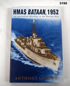
Book - HMAS BATAAN, KOREA 1952, Anthony Cooper, 2010
... Bendigo Military Museum 37 - 39 Pall Mall Bendigo goldfields HMAS Bataan 1952. ...HMAS Bataan 1952. An Australian Warship in the Korean War. "The author explores the variety of tasks and risks undertaken by the ship and her company in circumstances that were always challenging and sometimes highly dangerous" - Professor Jeffrey Grey.Hard cardboard cover, deep blue buckram with gold print on spine. Dust cover mid blue background, sea image, dark blue & gold print on front, spine & back. Sepia photos of HMAS Bataan on front & back covers. Gun crew on front flap, men on side of fo'c'sle back flap. 294 pages, cut plain paper illustrated with black & white photos, maps & diagrams.Handwritten in black on front fly leaf: Donated by Mrs Olive Pell BENDIGO DISTRICT RSL MUSEUMbooks-military-history-navy, korea -
 Bendigo Military Museum
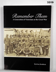
Book - BOOK, THE GREAT WAR, Remember Them, A Generation of Victorians at the Great War, 2010
... Bendigo Military Museum 37 - 39 Pall Mall Bendigo goldfields books-military-history Great War Victorians Handwritten in black ink on title page front fly leaf: "To Bendigo District RSL Museum with best wishes Katrina" On title page on front fly leaf: "RSL stamp" Soft cardboard cover. ...Soft cardboard cover. Black & white print on front, spine & back. Black background with sepia colour photo of a group portrait of soldiers on front in foreground. Inscription front fly leaf. 192 pages, cut, plain, white. Illustrated black & white photos, maps & illustrations.Handwritten in black ink on title page front fly leaf: "To Bendigo District RSL Museum with best wishes Katrina" On title page on front fly leaf: "RSL stamp"books-military-history, great war, victorians -
 Bendigo Military Museum
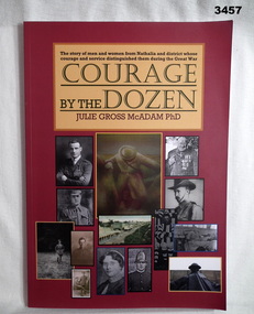
Book - BOOK, COURAGE, Julie Gross McAdam PhD, Courage by the Dozen, 2017
... Bendigo Military Museum 37 - 39 Pall Mall Bendigo goldfields The story of men & women from Nathalia & district whose courage & service distinguished them during the Great War. ...The story of men & women from Nathalia & district whose courage & service distinguished them during the Great War.Dark green, soft cardboard cover, black & dark red print on front, spine & back. Background is dark red, front illustrated collection of 14 black/ white, sepia & colour photos. Back has collection of 4 black / white photos & 1 colour poster. 107 pages, cut, plain, white. Illustrated, black/ white, sepia & colour photos, maps, newspaper clippings, certificates.book, courage, nathalia -
 Bendigo Military Museum
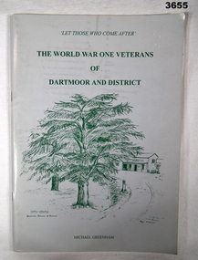
Booklet - BOOKLET, WW1, Michael Greenham, The World War One Veterans of Dartmoor & District, Post 1990 possibly
... Bendigo Military Museum 37 - 39 Pall Mall Bendigo goldfields Booklet Dartmoor WW1 Handwritten in black ink on title page: “Michael Greenham. ...Soft, cardboard cover. Light grey background with green print & illustrations of trees on front & back. Stapled. 96 cut, glossy white pages. Illustrated with black / white photos. End papers front & back. Illustrated maps. Inscriptions.Handwritten in black ink on title page: “Michael Greenham. Anzac Day 1995”booklet, dartmoor ww1 -
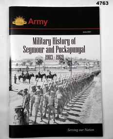 Bendigo Military Museum
Book - BOOK, Military History of Seymour and Puckapunyal Districts, "Military History of Seymour and Puckapunyal 1903 - 1969"
... Bendigo Military Museum 37 - 39 Pall Mall Bendigo goldfields Seymour and Puckapunyal areas Military history. ...Seymour and Puckapunyal areas Military history. "Spans well over 130 years from the Colonial days, the post Federation era, the First and Second World Wars, the Korean War and 1st National Service scheme to the Vietnam War and the 2nd National Service scheme".Soft cover book. Soft cover - heavy gauge paper, black, red and white print on front and back. Front illustrated black and white photograph soldiers on parade with background of buildings. Bacl - illustrated lightly coloured map. 65 pages - cut, plain, sewn, gloss white. Illustrated black and white, sepia and colour photographs and maps.book, military history, seymour and puckapunyal