
Showing 79 items matching "black hill gully"
-
 Ballarat Heritage Services
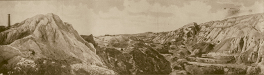
Photograph - Image - Black and White, Old Works, Black Hill Gully, Ballarat, c1904, c1904
... Old Works, Black Hill Gully, Ballarat, c1904...Black Hill was the Black Hill Company, formed in 1859. Mining from the open-cut mine probably commenced in 1860 and by 1861 the company had erected the largest stamping mill in Victoria. The mill ran 24 hours a day until the end of 1864 and 12 hours a day in 1865. Open cut mining then ceased. Underground ore extraction continued at Black Hill until the early twentieth century. ballarat black hill mining open cut gold Photographic image of the abandoned open-cut mine at Black Hill, Ballarat, c1904 Old Works, Black Hill Gully, Ballarat, c1904 Photograph Image - Black and White ...The first company to make a success of hard-rock (quartz) gold mining at Black Hill was the Black Hill Company, formed in 1859. Mining from the open-cut mine probably commenced in 1860 and by 1861 the company had erected the largest stamping mill in Victoria. The mill ran 24 hours a day until the end of 1864 and 12 hours a day in 1865. Open cut mining then ceased. Underground ore extraction continued at Black Hill until the early twentieth century.Photographic image of the abandoned open-cut mine at Black Hill, Ballarat, c1904 ballarat, black hill, mining, open cut, gold -
 Federation University Historical Collection
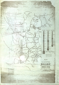
Plan, Plan of Leads and Gold Workings at Baallarat Showing the Complications Under the Frontage System, 1863, 1863
... ...black hill gully...Barker Library (top floor) Mount Helen goldfields Facsimile of a plan held by the Public Record Office Victoria. ballarat mining inkermann lead golden point lead robert davidson terrible lead white horse lead frenchman's lead little magpie lead milkmaid's lead woolshed lead nuggety lead blackman's lead canadian lead sailor's gully lad nightingale lead malakoff lead black hill gully pennyweight flat black hill winter's pre-emptive right nelson company great extended great republic lead cgt Facsimile of a plan of Ballarat showing leads, gold workings an dthe frontage system. ...Facsimile of a plan held by the Public Record Office Victoria. Facsimile of a plan of Ballarat showing leads, gold workings an dthe frontage system.ballarat, mining, inkermann lead, golden point lead, robert davidson, terrible lead, white horse lead, frenchman's lead, little magpie lead, milkmaid's lead, woolshed lead, nuggety lead, blackman's lead, canadian lead, sailor's gully lad, nightingale lead, malakoff lead, black hill gully, pennyweight flat, black hill, winter's pre-emptive right, nelson company, great extended, great republic lead, cgt -
 Old Colonists' Association of Ballarat Inc.
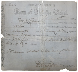
Document, Form of Register Ticket made out to William Fittall, 1862
... Form of Register Ticket No. 224 Schedule XXVII By Law XIII February 11th 1862 I, P.P.FitzPatrick Mining Registrar for the No 2 division of the Mining District of Ballaarat, have this eleventh day pf February 1862 registered Willia Fittall for a residence claim, 66 feet by 82 1/2 feet situated east of Peel Steeet near Black Hill Gully (signed) William Fittall on 28 January 1862...Old Colonists' Association of Ballarat Inc. 16-14 Lydiard (North) Street Ballarat Central goldfields Sailor immigration Thomas Paterson Greenock George Dempster Chevalier Form of Register Ticket No. 224 Schedule XXVII By Law XIII February 11th 1862 I, P.P.FitzPatrick Mining Registrar for the No 2 division of the Mining District of Ballaarat, have this eleventh day pf February 1862 registered Willia Fittall for a residence claim, 66 feet by 82 1/2 feet situated east of Peel Steeet near Black Hill Gully (signed) William Fittall on 28 January 1862 Small ticket stub for a Form of Register Ticket Form of Register Ticket made out to William Fittall, 1862 Document ...Small ticket stub for a Form of Register TicketForm of Register Ticket No. 224 Schedule XXVII By Law XIII February 11th 1862 I, P.P.FitzPatrick Mining Registrar for the No 2 division of the Mining District of Ballaarat, have this eleventh day pf February 1862 registered Willia Fittall for a residence claim, 66 feet by 82 1/2 feet situated east of Peel Steeet near Black Hill Gully (signed) William Fittall on 28 January 1862sailor, immigration, thomas paterson, greenock, george dempster, chevalier -
 Emerald Museum & Nobelius Heritage Park
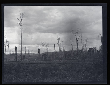
Negative - Image of The Railway Line, Baker & Rouse, Early 20th century
... Gully to Gembrook railway line, which was completed in December 1900. The view looks northwards to the hills from probably present-day Station Road. This stark image of bare landscape with dead trees recalls both the early timber industry in Gembrook and the practice of wide-spread clearing of land for farming use. Gembrook timber industry Railway 1900 early 20th century Station Rd Handwritten on (not original) packet containing negative: 'Railway line & dead trees /Gembrook' Black ...This negative is one of a batch of ten images taken apparently around the same time at Gembrook c. early 20th century. This one is of the Ferntree Gully to Gembrook railway line, which was completed in December 1900. The view looks northwards to the hills from probably present-day Station Road. This stark image of bare landscape with dead trees recalls both the early timber industry in Gembrook and the practice of wide-spread clearing of land for farming use.Black and white negative - landscape view - of the railway line at Gembrook. The railway is in the foreground. The landscape is bare apart from dead and ringbarked trees. Negative has been kept inside a packet which is not original.Handwritten on (not original) packet containing negative: 'Railway line & dead trees /Gembrook'gembrook, timber industry, railway, 1900, early 20th century, station rd -
 Eltham District Historical Society Inc
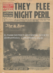
Newspaper - Newspaper articles, Sun News-Pictorial, They Flee Night Peril, The Sun News-Pictorial, Wednesday, January 17, p1, 1962
... Hill...Ringwood...Woori Yallock...Leslie Ockwell...Linda Ockwell...Kalorama...Healesville...Daylesford...Fire Damage – buildings...Wye River...Portland...Eganstown...Ballarat...Sherbrooke Park Forest...Forest Commission Headquarters...Kallista...R.T. Seaton...Montrose...Yallourn...Central Gippsland...Smith’s Creek...Black Friday...Geoffrey Ockwell...Ronald Ockwell...Preston Town Hall...E.J. Tenner...Strathewen...Kangaroo Ground...Eric Farnsworth...Adele Farnsworth...Robin Farnsworth...Roy Cleland...Ann Cleland...Belgrave...Sassfras...Kaloramalice Commissioner Porter...Mansfield...Box Hill Hospital...Pound Bend...Ferntree Gully...Hill and Hurstbridge on page 1, Warrandyte on page 2, 3, 4 and 5, Hurstbridge, Smith’s Gully, Kinglake on page 3 and 4, Strathewen, Kangaroo Ground, Panton Hill, St. Andrews, Smith’s Gully on page 4 and Pound Bend, Smith’s Gully and Warrandyte on pages 20-21 • They Flee Night Peril, p1 (Illust.) • Their grim picnic; A flash fire strikes, p2 (Illust.) • Night of terror as towns quitted, p3 • Fought till he dropped, p3 (Illust.) • Rain in fire area, p3 • Wye River town goes, p3 • Black Friday Hero Dies In Fire; with wife, grandsons, p4 • Surrounded!...Hill and Hurstbridge on page 1, Warrandyte on page 2, 3, 4 and 5, Hurstbridge, Smith’s Gully, Kinglake on page 3 and 4, Strathewen, Kangaroo Ground, Panton Hill, St. Andrews, Smith’s Gully on page 4 and Pound Bend, Smith’s Gully and Warrandyte on pages 20-21 • They Flee Night Peril, p1 (Illust.) • Their grim picnic; A flash fire strikes, p2 (Illust.) • Night of terror as towns quitted, p3 • Fought till he dropped, p3 (Illust.) • Rain in fire area, p3 • Wye River town goes, p3 • Black Friday Hero Dies In Fire; with wife, grandsons, p4 • Surrounded! ...Various news articles pertaining to the January 1962 Victorian bushfires in the Dandenong and Healesville districts which by the third day had encompassed large areas of the State. Specific Eltham Shire districts mentioned include Panton Hill and Hurstbridge on page 1, Warrandyte on page 2, 3, 4 and 5, Hurstbridge, Smith’s Gully, Kinglake on page 3 and 4, Strathewen, Kangaroo Ground, Panton Hill, St. Andrews, Smith’s Gully on page 4 and Pound Bend, Smith’s Gully and Warrandyte on pages 20-21 • They Flee Night Peril, p1 (Illust.) • Their grim picnic; A flash fire strikes, p2 (Illust.) • Night of terror as towns quitted, p3 • Fought till he dropped, p3 (Illust.) • Rain in fire area, p3 • Wye River town goes, p3 • Black Friday Hero Dies In Fire; with wife, grandsons, p4 • Surrounded!, p4 (Illust.) • Main street houses ablaze, p4 • Hurstbridge is evacuated, p4 • Scores jump in river at Warrandyte, p5 • Hills people leave homes, p5 • “Fire” cry at Parlt., p5 • Blind – he’s safe now, p5 (Illust.) • Police Chief Runs Battle, p7 • From Fire Front: Hospital treats 34, p7 • Firms send help, p7 • Tragedy and Ruin: Third Day; Ferntree Gully; Warrandyte; Pound Bend; Smiths Gully; Escape for 18, pp20-21 (Illust.) • Church was a haven for the hurt, weary, p39 (Illust.) • A home is lost, p40 (Illust.) tom fielding collection, victorian bushfires - 1962, victorian bushfires – 1962, panton hill, hurstbridge, five ways crossroads, warrandyte south, dandenongs, upwey, mt. evelyn, monbulk, olinda, sassafras, st. andrews, warrandyte, christmas hills, yarra river, mitcham, whitehorse roiad, donvale, park orchards, metropolitan fire chief, w.t. aldridge, loughnan’s hill, ringwood, woori yallock, leslie ockwell, linda ockwell, kalorama, healesville, daylesford, fire damage – buildings, wye river, portland, eganstown, ballarat, sherbrooke park forest, forest commission headquarters, kallista, r.t. seaton, montrose, yallourn, central gippsland, smith’s creek, black friday, geoffrey ockwell, ronald ockwell, preston town hall, e.j. tenner, strathewen, kangaroo ground, eric farnsworth, adele farnsworth, robin farnsworth, roy cleland, ann cleland, belgrave, sassfras, kaloramalice commissioner porter, mansfield, box hill hospital, pound bend, ferntree gully, ferntree gully state school, w. carew, ann quinton -
 Eltham District Historical Society Inc
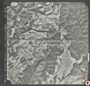
Photograph - Aerial Photograph, Smiths Gully, Christmas Hills, St Andrews, Kinglake National Park, 6 Mar. 1986
... Eltham District Historical Society Inc 728 Main Rd Eltham melbourne Small scale Red arrow indicates North shire of eltham archives Aerial Photo Christmas Hills Kinglake National Park smiths gully St Andrews Black and white proto print; Size: 235x245 mm Condition: Good Smiths Gully, Christmas Hills, St Andrews, Kinglake National Park Photograph Aerial Photograph ...Small scale Red arrow indicates Northshire of eltham archives, aerial photo, christmas hills, kinglake national park, smiths gully, st andrews -
 Eltham District Historical Society Inc
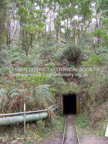
Photograph - Digital Photograph, Marguerite Marshall, One Tree Hill Mine, Smiths Gully, 8 June 2006
... Black Cameron Mine and worked there until 1988. Stan resumed mining One Tree Hill in 1998. As late as the 1920s gold was picked up by chance! When crossing a gully...Black Cameron Mine and worked there until 1988. Stan resumed mining One Tree Hill in 1998. As late as the 1920s gold was picked up by chance! When crossing a gully ...Gold was discovered on One Tree Hill in 1854. The site has been worked intermittently until fairly recent times. Published: Nillumbik Now and Then / Marguerite Marshall 2008; photographs Alan King with Marguerite Marshall.; p53 Though still a working mine, One Tree Hill Mine at Smiths Gully, now stands in a tranquil reserve surrounded by bush and native animals - in contrast to its heyday. In the mid 19th century, when the mine was part of the Caledonia Goldfields, hundreds of men in search of their fortune worked the alluvial gold in the Yarra River, its tributaries and the reefs that made up the goldfields. Miner Stan Bone, assisted by Wilfred Haywood, is the last of the independent gold miners in the area and still uses the quartz crushing battery as miners did when gold was first discovered in the area in 1851.1 Stan, who is the last of six generations of miners in his family, was aged 17 when he began mining on his father Alex’ mine, The Golden Crown in Yarrambat. These days, after blasting the gold-bearing rock in Mystery Reef, one of the four reefs at One Tree Hill, Stan transports it around five kilometres by tip truck to the Black Cameron Mine for crushing. There he uses water from the waterlogged mine, (which still contains gold), as the Happy Valley Creek at One Tree Hill is usually dry.2 The One Tree Hill Mine has been worked for close to a century since it opened around the late 1850s.3 The Swedish Reef was its most productive reef and one of the largest in the area. Around 1859, extractions included 204 ounces (5.8kg) of gold, won from 57 pounds (26kg) of stone.4 Then during World War Two, Stan’s uncle, Bill Wallace, and Alex Bone, closed the mine. In 1973, Stan, with his Uncle Bill, reopened the Black Cameron Mine and worked there until 1988. Stan resumed mining One Tree Hill in 1998. As late as the 1920s gold was picked up by chance! When crossing a gully on his way to vote at the St Andrews Primary School, Bill Joyce picked up some quartz containing gold. This site was to become the Black Cameron Mine. The Caledonia Diggings, named after Scotland’s ancient name by local Scots, began around Market Square (now Smiths Gully) and included Queenstown (St Andrews), Kingstown (Panton Hill) and Diamond Creek. There were also poorer bearing fields in Kangaroo Ground and Swipers Gully (now Research). * None of these compared in riches to the Ballarat and Bendigo fields5, but the Caledonia Diggings continued intermittently for close to 100 years. Gold was discovered in Victoria following a bid to stem the disappearance of much needed workmen to the New South Wales diggings. Several businessmen offered a reward of £200, for the discovery of gold within 200 miles (322 km) of Melbourne. Late in June 1851, gold was first discovered at Andersons Creek, Warrandyte. Then in 1854, George Boston and two other men discovered gold at Smiths Gully. Gold transformed the quiet districts, with a constant flow of families and vehicles on the dirt tracks en route to the Caledonia Diggings. Three thousand people worked the gullies in Market Square, including about 1000 Chinese miners. The square established its own police, mining warden, gold battery, school, shops and cemetery and grog flowed. Market Square flourished until the middle 1860s. Bullocks transported quartz from the Caledonia Goldfields to the crushing machinery at the Queenstown/St Andrews Battery, near Smiths Gully Cemetery. It was destroyed by bushfire in 1962. By the late 1850s, most early alluvial fields were in decline, but minor rushes continued until around 1900 and some until the early 1940s. Some miners did well, although most earned little from their hard labour in the harsh and primitive conditions.6 But according to historian, Mick Woiwod, the gold fields helped to democratise society, as individuals from all walks of life were forced to share experiences, and the ability to succeed, depended less on inherited wealth or social rank.This collection of almost 130 photos about places and people within the Shire of Nillumbik, an urban and rural municipality in Melbourne's north, contributes to an understanding of the history of the Shire. Published in 2008 immediately prior to the Black Saturday bushfires of February 7, 2009, it documents sites that were impacted, and in some cases destroyed by the fires. It includes photographs taken especially for the publication, creating a unique time capsule representing the Shire in the early 21st century. It remains the most recent comprehenesive publication devoted to the Shire's history connecting local residents to the past. nillumbik now and then (marshall-king) collection, gold mining, one tree hill mine, smiths gully -
 Eltham District Historical Society Inc
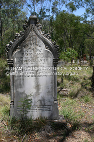
Photograph - Digital Photograph, Alan King, Queenstown Cemetery, Smiths Gully Road, St Andrews, 28 December 2007
... Hill’. The lump of gold found this time weighed more than half a kilo. Mr Hopkinson referred to it as ‘another little speck’. *Today’s Smiths Gully This collection of almost 130 photos about places and people within the Shire of Nillumbik, an urban and rural municipality in Melbourne's north, contributes to an understanding of the history of the Shire. Published in 2008 immediately prior to the Black ...The discovery of gold in Smyth's Creek in 1854 and subsequent gold rush to the Caledonia diggings led to the establishment of Queenstown (present day St Andrews). The first recorded burial was July 31st, 1861 and it was officially declared a Cemetery Reserve in 1866. Many graves are unmarked and unrecorded including many Chinese and other itinerant miners. The cemetery was closed for new burials in 1851. The last recorded burial was in 1981 in an existing family grave. In Loving memory of David Band Died 30th Decr. 1862, aged 51 years. John Cork Knell Died 11th April 1867, aged 42 years. Eliza Smith Died 20th Jany. 1874, aged 3 1/2 years. William Band Died 20th Feby. 1883, aged 51 years. Published: Nillumbik Now and Then / Marguerite Marshall 2008; photographs Alan King with Marguerite Marshall.; p73 The discovery of gold at Smyth’s Creek* in 1854 brought 3000 people to the area in search of their fortunes.1 However in the harsh conditions many miners and their families died young, and were buried in unmarked graves. Their stories died with them but by 1861, the first burial was recorded at the Queenstown Cemetery – that of William Dalrymple aged 65 – although the cemetery was only officially declared a reserve in 1866. Even before this in 1856, a double burial had been recorded for the twin baby daughters of George Harrison at Market Square, the miners’ settlement – presumably where the cemetery is today. In 1951 the Queenstown Cemetery at 70 Smiths Gully Road, Smiths Gully, closed for burials. However the last burial in a family plot, that of Grace Evelyn Smith, occurred in 1981. Today only 55 headstones remain, but more than 380 burials are recorded. Remnant bushland dominates the cemetery where many graves are merely mounds and others have been damaged by vandalism and the neglect of time. Bushfire in 1962 destroyed the picket fencing, grave markers and cypress boundary planted in the early 1900s. The box/stringybark woodland in the 1.7 hectare Cemetery Reserve is regrowth from then and the indigenous and heritage vegetation is protected. Thanks to the volunteer Cemetery Trust and Friends & Relations of Queenstown Cemetery, the cemetery is maintained, stories recorded and the burial index corrected and expanded.2 Close by the cemetery on the site of today’s Peter Franke Picnic and Nature Reserve stood Market Square, the Caledonia Diggings village of tents and stores, the forerunner of Queenstown, now St Andrews. Many of the Caledonia Diggings miners were Chinese, many of whom, with itinerant prospectors, were buried in unmarked graves. Histories are being recorded of other immigrants, mainly English and German, who settled after the gold rush, some of whose descendants fought and died in the two world wars. Names on many headstones are also recorded on the district’s roads, reserves and war memorials such as Motschall, Joyce, Howard and Coutie. The oldest surviving tombstone is that of Scot, David Band who died in 1862 at 51 years. His oldest daughter Elizabeth, with husband John Knell, owned the Queenstown Hotel and the post office. Child-rearing in a colonial gold town was often tragically difficult, as demonstrated in the first 20 years, when 41% of the 34 burials recorded were children. Settlers endured harsh conditions graphically illustrated with the deaths of Annie Joyce at 30 years and of her family. Annie was married to gold miner Walter Joyce. Their third child Walter, born in 1886, died in March 1887. Eight months later Annie died of breast cancer. Walter died in 1909, aged 53, of miner’s phthisic caused by stone dust destroying his lungs. It was so hard to make a living that burials were usually held from 2.30 pm to allow mourners to work a day before paying their last respects.3 Most burials before 1890 were recorded as Anglicans, as the only church on the Caledonia Diggings was the Church of St Andrew, until 1897, when the Primitive Methodist Church came to Panton Hill. Generally miners came to better themselves, but some, like Grace Hopkinson (nee Milward), born in England in 1828, came from a well-off and educated family. According to family legend Grace emigrated with husband William, to live in a tent, but had kept her personally embossed sterling silver cutlery service. Amid the tough environment were some successes like that reported in The Evelyn Observer April/May 1901 of miner William Hopkinson who was buried at the cemetery in 1912 aged 81. The Observer stated that Hopkinson ‘recently dropped across another find in his claim at One Tree Hill’. The lump of gold found this time weighed more than half a kilo. Mr Hopkinson referred to it as ‘another little speck’. *Today’s Smiths GullyThis collection of almost 130 photos about places and people within the Shire of Nillumbik, an urban and rural municipality in Melbourne's north, contributes to an understanding of the history of the Shire. Published in 2008 immediately prior to the Black Saturday bushfires of February 7, 2009, it documents sites that were impacted, and in some cases destroyed by the fires. It includes photographs taken especially for the publication, creating a unique time capsule representing the Shire in the early 21st century. It remains the most recent comprehenesive publication devoted to the Shire's history connecting local residents to the past. nillumbik now and then (marshall-king) collection, david band, eliza smith, gravestones, john cork knell, queenstown cemetery, smiths gully road, st andrews, william band -
 Bendigo Historical Society Inc.
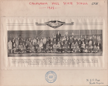
Photograph - STUDENTS OF CALIFORNIA HILL STATE SCHOOL, 1928
... Black and white reproduction of photo from 'Back to Eaglehawk' back Oct. 1928. Large group of children, four adults in background. Outside. Banisters in background, brick wall at side. Approximately ninety children, youngest ones seated on ground at front, cross-legged. Inscriptions: on front - 'California Hill State School, 1928', 'JH Biggs, Health Inspector'. RHSV stamp (under photo). California Hill State School. 'The California Gully...hill state.school Black and white reproduction of photo from 'Back to Eaglehawk' back Oct. 1928. Large group of children, four adults in background. Outside. Banisters in background, brick wall at side. Approximately ninety children, youngest ones seated on ground at front, cross-legged. Inscriptions: on front - 'California Hill State School, 1928', 'JH Biggs, Health Inspector'. RHSV stamp (under photo). California Hill State School. 'The California Gully ...Black and white reproduction of photo from 'Back to Eaglehawk' back Oct. 1928. Large group of children, four adults in background. Outside. Banisters in background, brick wall at side. Approximately ninety children, youngest ones seated on ground at front, cross-legged. Inscriptions: on front - 'California Hill State School, 1928', 'JH Biggs, Health Inspector'. RHSV stamp (under photo). California Hill State School. 'The California Gully State School (or the Bell topper Hill, as the old Cornish miners names it) is one of the oldest in the district. Some of the prominent men of Bendigo today who attended that school include Cr. JH Curnow, Mr Jtn Smalley, and Mr EE Heitman. Mr. George Evans, a native of the district, is now in charge of the school. Miss FE Darvall is the head of the infant division. Other teachers are Miss RE Nicholas and Mr WR McClelland. Scholars on the roll at present number 105.person, group, students of cal. hill state.school -
 Bendigo Historical Society Inc.
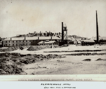
Photograph - KOCK'S PIONEER QUARTZ CRUSHING PLANT
... Black and white photograph. View of large mining plant and associated chimneys. Open (waste) area in foreground. Low hill in background. Inscriptions: on front 'Kock's Pioneer Quartz Crushing Plant, Long Gully', Perserverance United Windmill Hill in background'. ...Black and white photograph. View of large mining plant and associated chimneys. Open (waste) area in foreground. Low hill in background. Inscriptions: on front 'Kock's Pioneer Quartz Crushing Plant, Long Gully', Perserverance United Windmill Hill in background'. ...Black and white photograph. View of large mining plant and associated chimneys. Open (waste) area in foreground. Low hill in background. Inscriptions: on front 'Kock's Pioneer Quartz Crushing Plant, Long Gully', Perserverance United Windmill Hill in background'. On back - 'A Richardson, 29 Harrison St, Bendigo'.mining, crushing & milling, kock's pioneer quartz crushing plant, bendigo, mines and mining, mines, mine, mining, crushing plant, landscape, mining landscape, quartz, perserverance united windmill -
 Bendigo Historical Society Inc.
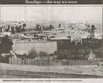
Newspaper - LONG GULLY HISTORY GROUP COLLECTION: BENDIGO - THE WAY WE WERE - LONG GULLY
... Black and white photo from Bendigo - the way we were series in the Bendigo Advertiser, November 14, 2000. The photo shows the township of Long Gully, Ironbark Hill in the distance. ...History House 11 Mackenzie Street Bendigo goldfields BENDIGO History long gully history group The Long Gully History Group - Bendigo - The way we were - Long Gully Bendigo Advertiser 14/11/2000 Ironbark Hill Black and white photo from Bendigo - the way we were series in the Bendigo Advertiser, November 14, 2000. ...Black and white photo from Bendigo - the way we were series in the Bendigo Advertiser, November 14, 2000. The photo shows the township of Long Gully, Ironbark Hill in the distance. Date unknown. The photo shows houses, mine chimneys, trees and a rough picket type fence in the foreground.bendigo, history, long gully history group, the long gully history group - bendigo - the way we were - long gully, bendigo advertiser 14/11/2000, ironbark hill -
 Bendigo Historical Society Inc.
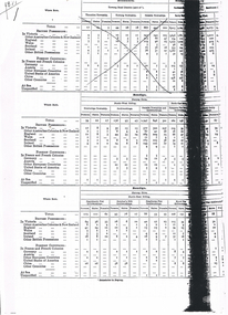
Document - LONG GULLY HISTORY GROUP COLLECTION: BIRTHPLACES OF THE PEOPLE - MARONG, HUNTLY & STRATHFIELDSAYE
... Hill Township, Grusoe Gully Township, -?- and Lockwood Township. Strathfieldsaye Shire consists of the East Riding and the West Riding which consists of Milkmaid Flat Goldworkings, Diamond Hill Goldworkings, -?-, Sheepwash Gully Goldworkings, Spring Gully Goldworkings, Tin-pot Gully Goldworkings, Golden Gully Goldworkings, Kangaroo Flat and Gully Goldworkings and Outside Goldworkings. Huntly Shire consists of the Huntly Township, Huntly Goldworkings, Ascot Township, -?-, and Outside Townships. Each table lists the number of Persons, Males and Females and the places mentioned earlier where they were born. Black...Hill Township, Grusoe Gully Township, -?- and Lockwood Township. Strathfieldsaye Shire consists of the East Riding and the West Riding which consists of Milkmaid Flat Goldworkings, Diamond Hill Goldworkings, -?-, Sheepwash Gully Goldworkings, Spring Gully Goldworkings, Tin-pot Gully Goldworkings, Golden Gully Goldworkings, Kangaroo Flat and Gully Goldworkings and Outside Goldworkings. Huntly Shire consists of the Huntly Township, Huntly Goldworkings, Ascot Township, -?-, and Outside Townships. Each table lists the number of Persons, Males and Females and the places mentioned earlier where they were born. Black ...Copies of some pages titled Birthplaces of the People. Tables are divided into each shire under the heading of Bendigo. Birthplaces are divided into British Possessions including Victoria and Foreign Countries including France and French Colonies and Other Fountries, At Sea and Unspecified. Bendigo is divided into Sandhurst City - -?- Ward and Sutton Ward, Eaglehawk Borough and Raywood Borough. Marong Shire is divided into North-West Riding which consists of Newbridge Township, Goldworkings and Outside Township and Goldworkings, Bridgewater Township and Myerstown Township. North-East Riding consists of Kangaroo Flat -?- Goldworkings, Eaglehawk Gully Goldworkings, Eaglehawk Flat Goldworkings, Butcher'sHill Goldworkings, Deadhorse Flat Goldworkings,Myers' Flat Goldworkings and -?- Flat Goldworkings. Maiden Gully Goldworkings, Kangaroo Flar Goldworkings, Epsom Township, Neilborough Township, Whipstick Goldworkings, -?- Goldworkings, Sebastian Goldworkings, Sydney Flat Goldworkings, other Goldworkings, Outside Townships and Goldworkings. South Riding of the Marong Shire consists of Ravenswood Township, Big Hill Township, Grusoe Gully Township, -?- and Lockwood Township. Strathfieldsaye Shire consists of the East Riding and the West Riding which consists of Milkmaid Flat Goldworkings, Diamond Hill Goldworkings, -?-, Sheepwash Gully Goldworkings, Spring Gully Goldworkings, Tin-pot Gully Goldworkings, Golden Gully Goldworkings, Kangaroo Flat and Gully Goldworkings and Outside Goldworkings. Huntly Shire consists of the Huntly Township, Huntly Goldworkings, Ascot Township, -?-, and Outside Townships. Each table lists the number of Persons, Males and Females and the places mentioned earlier where they were born. Black marks on paper make some of it unreadable.bendigo, history, long gully history group, the long gully history group - birthplaces of the people - marong, huntly & strathfieldsaye -
 Bendigo Historical Society Inc.
Photograph - LONG GULLY HISTORY GROUP COLLECTION: TOWNSHIP OF LONG GULLY
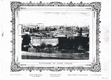
... Black & white photocopy of a photo of the Township of Long Gully. Print has a decorative frame around it. Photo taken by N J Caire, Sandhurst, which is printed just inside the frame. A Carey & Wenborn's Print, printed on the left under the frame, then Iron Bark Hill...History House 11 Mackenzie Street Bendigo goldfields BENDIGO History long gully history group The Long Gully History Group - Township of Long Gully N J Caire Carey & Wenborn Iron Bark Hill Victoria Hill Main Street Long Gully Forbes & Holmes St Mathews Long Gully Methodist Church Long Gully Sunday School Long Gully Kindergarten Long Gully Post Office N J Caire Black & white photocopy of a photo of the Township of Long Gully. ...Black & white photocopy of a photo of the Township of Long Gully. Print has a decorative frame around it. Photo taken by N J Caire, Sandhurst, which is printed just inside the frame. A Carey & Wenborn's Print, printed on the left under the frame, then Iron Bark Hill, in the distance. Victoria Hill, in the distance. Main Street Long Gully. Forbes & Holmes, Agents. Photo shows a road and a picket fence in the foreground with houses, mine chimneys, poppet legs and mine buildings in the background. On the left horizon an area has been drawn around. Written on the back is: 1857 Started Methodism on the Site of the Present St Mathews. 1853 Methodism Started services were held open air. St Mathews Church Built 1883. Sunday School 1896 Long Gully Methodist Church 1877 Sunday School 1871 Kindergarten 1905 Long Gully Post Office Built Early Methodist Church Built Creeth St & Eaglehawk Rd was a Wooden Building got burnt down. (Ethel Leggo) Another copy of this photo 11010.44N J Cairebendigo, history, long gully history group, the long gully history group - township of long gully, n j caire, carey & wenborn, iron bark hill, victoria hill, main street long gully, forbes & holmes, st mathews, long gully methodist church, long gully sunday school, long gully kindergarten, long gully post office -
 Bendigo Historical Society Inc.
Photograph - ST. MUNGO AND DEVONSHIRE GROUP OF MINES, 1888
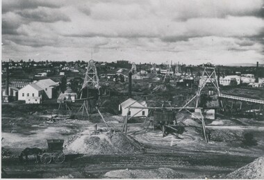
... black and white photograph: St, Mungo and Devonshire Group of Mines, looking south, California Gully Primary School in the background. Mng 25 ( black pen ) also in black ball point pen ' The St. Mungo and Devonshire group of Mines, Eaglehawk, looking south 1888. Foreground left - cab, windlass, whip and whim. Left to right, Old St. Mungo, Sadova, Background, The Deveonshire mines . At rear, Califronia Gully State School. View from Snob's Hill...black and white photograph: St, Mungo and Devonshire Group of Mines, looking south, California Gully Primary School in the background. Mng 25 ( black pen ) also in black ball point pen ' The St. Mungo and Devonshire group of Mines, Eaglehawk, looking south 1888. Foreground left - cab, windlass, whip and whim. Left to right, Old St. Mungo, Sadova, Background, The Deveonshire mines . At rear, Califronia Gully State School. View from Snob's Hill ...black and white photograph: St, Mungo and Devonshire Group of Mines, looking south, California Gully Primary School in the background. Mng 25 ( black pen ) also in black ball point pen ' The St. Mungo and Devonshire group of Mines, Eaglehawk, looking south 1888. Foreground left - cab, windlass, whip and whim. Left to right, Old St. Mungo, Sadova, Background, The Deveonshire mines . At rear, Califronia Gully State School. View from Snob's Hill, in foreground. St. Mungo and Sadowa with the Lady Barkly in the distance, whilst to the right of the Lady Barkly is the joint battery of the South St. Mungo and Lady Barkly Companies, then follows the South St. Mungo mine, The Uinicorn, and the Phoenix, and in the background, the Devonshire Group ( as identified by J. Lerk in Bendigo's Gold Mining History 1851 - 1954 )organization, business, st. mungo and devonshire mines -
 Bendigo Historical Society Inc.
Photograph - EXTENDED HUSTLERS FREEHOLD
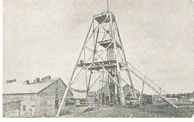
... black and white photograph of Great Extended Hustlers Freehold poppet head, now at Wattle Gully, Chewton ( james Lerk 26.22.1999 ) Poppet head in front of mining buildings, stacks of sawn timber tonight. Great Extended Hustlers/locality/Hustlers Hill...History House 11 Mackenzie Street Bendigo goldfields ORGANIZATION Business great extended hustlers mine black and white photograph of Great Extended Hustlers Freehold poppet head, now at Wattle Gully, Chewton ( james Lerk 26.22.1999 ) Poppet head in front of mining buildings, stacks of sawn timber tonight. Great Extended Hustlers/locality/Hustlers Hill ...black and white photograph of Great Extended Hustlers Freehold poppet head, now at Wattle Gully, Chewton ( james Lerk 26.22.1999 ) Poppet head in front of mining buildings, stacks of sawn timber tonight. Great Extended Hustlers/locality/Hustlers Hill Nth. Bendigo/ formed 1865/last production 1921. Depth of shaft 3,470 ( 1045 m ) Poppet legs, steel 70 feet high ( 21.08 ) Gold very rich, total yield 300,000 ozs. Dividends 675,000 pounds sterling ( $1,350,000 )organization, business, great extended hustlers mine -
 Bendigo Historical Society Inc.
Photograph - GREAT EXTENDED HUSTLERS MINE
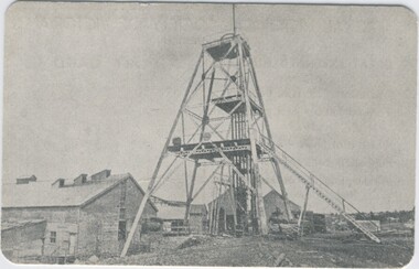
... black and white postcard. Great extended Hustlers poppet head, now at Wattle Gully, Chewton ( J. Lerk 26.22.1999 ) Poppet head in front of mining buildings, stacks of sawn timber to right. Written on back ' Royal Historical Society of Victoria Bendigo Branch, printed across top. Great Extended Hustlers/locality/ Hustlers Hill...black and white postcard. Great extended Hustlers poppet head, now at Wattle Gully, Chewton ( J. Lerk 26.22.1999 ) Poppet head in front of mining buildings, stacks of sawn timber to right. Written on back ' Royal Historical Society of Victoria Bendigo Branch, printed across top. Great Extended Hustlers/locality/ Hustlers Hill ...black and white postcard. Great extended Hustlers poppet head, now at Wattle Gully, Chewton ( J. Lerk 26.22.1999 ) Poppet head in front of mining buildings, stacks of sawn timber to right. Written on back ' Royal Historical Society of Victoria Bendigo Branch, printed across top. Great Extended Hustlers/locality/ Hustlers Hill, Nth. Bendigo/Formed 1865/Last production 1921/Depth of Shaft 3470 feet/Poppet Legs - Steel, 70 feet high. /Winding Engine: First motion 8 ft. drums/Gold Very Rich/Total Yield - 300,000 ozs. / Dividends $675,000. 'Post Card' printed on RH side.organization, business, great extended hustlers mine -
 Bendigo Historical Society Inc.
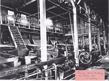
Photograph - LONG GULLY HISTORY GROUP COLLECTION: INSIDE OF OLD BATTERY AT VICTORIA HILL LONG GULLY
... Black and whit photo of the Inside of old Battery at Victoria Hill, Long Gully. ...History House 11 Mackenzie Street Bendigo goldfields BENDIGO History long gully history group The Long Gully History Group - Inside of Old Battery at Victoria Hill Long Gully Black and whit photo of the Inside of old Battery at Victoria Hill, Long Gully. ...Black and whit photo of the Inside of old Battery at Victoria Hill, Long Gully. Photo shows some men working among the belts and pulleys, one is about to upend a tub. There is another part upstairs. A high long shaft drives another shaft near the floor level.bendigo, history, long gully history group, the long gully history group - inside of old battery at victoria hill long gully -
 Bendigo Historical Society Inc.
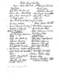
Document - LONG GULLY HISTORY GROUP COLLECTION: OLD LONG GULLY FROM RAE'S HILL TO MCGOWAN ST
... Titled Old Long Gully From Rae's Hill to McGowan St. LG. West Side - Jack Read Painter etc, Norris Bros Black Shop, Norris Bros Wood Yard & Chaff Mills, Iron Bark East Gold Mine, Sunday School, Tennis Courts Sunday School & Church, LG Fire Brigade, Creeth Street, Mine Managers Residence, Shop, Shop Mrs Hocking, Chinese Laundry, Allpress the Baker, Greenfell the Butcher, Hairdresser Beckinsall was the Fire Brigade Hotel, Dick White the Saddler, Store, Hotel Rose of Australia, Woodyard, Blacksmith Shop Wagon Repairer, Hotel Kocks (Pioneer Hotel), 2 China Shops owned by Chinese, Hotel Silver mines Hotel, Police Station, Grocers Shop (per? ...Reef Mine Hotel Connell Dr Selby Pentreath Kocks Machine Shop Kocks Mine Office Kocks Material Shop Dyson's Dam Kocks Mine Needle Mine Norm Shotples German School Victoria Consols Helen Gorlay Long Gully School Frank Cusack Bendigo Trust Titled Old Long Gully From Rae's Hill to McGowan St. LG. West Side - Jack Read Painter etc, Norris Bros Black Shop, Norris Bros Wood Yard & Chaff Mills, Iron Bark East Gold Mine, Sunday School, Tennis Courts Sunday School & Church, LG Fire Brigade, Creeth Street, Mine Managers Residence, Shop, Shop Mrs Hocking, Chinese Laundry, Allpress the Baker, Greenfell the Butcher, Hairdresser Beckinsall was the Fire Brigade Hotel, Dick White the Saddler, Store, Hotel Rose of Australia, Woodyard, Blacksmith Shop Wagon Repairer, Hotel Kocks (Pioneer Hotel), 2 China Shops owned by Chinese, Hotel Silver mines Hotel, Police Station, Grocers Shop (per? ...Titled Old Long Gully From Rae's Hill to McGowan St. LG. West Side - Jack Read Painter etc, Norris Bros Black Shop, Norris Bros Wood Yard & Chaff Mills, Iron Bark East Gold Mine, Sunday School, Tennis Courts Sunday School & Church, LG Fire Brigade, Creeth Street, Mine Managers Residence, Shop, Shop Mrs Hocking, Chinese Laundry, Allpress the Baker, Greenfell the Butcher, Hairdresser Beckinsall was the Fire Brigade Hotel, Dick White the Saddler, Store, Hotel Rose of Australia, Woodyard, Blacksmith Shop Wagon Repairer, Hotel Kocks (Pioneer Hotel), 2 China Shops owned by Chinese, Hotel Silver mines Hotel, Police Station, Grocers Shop (per? Reef Mine Hotel) E Bryant, Mine Windmill, Church Residence, Minister. East Side - Hopetoun Band R, Manchester Arms Hotel, Minister House, Church, IOR Hall, Shop Lollies Icecream, Boot Maker & Repairer, Back Smith Shop, Shop Childrens Wear, Butchers Shop, Creeth Street, Grocers Shop, Lolly Shop & Soft Drinks, Boot Maker & Repairer, Residence (Davey's), Lollie Shop (Fields), Dressmaker, LG Post Office (M Webb), Millars Bakers Shop, Butcher Shop, Mechanics Institute Books & Paper & Billiard Room, Connell the Baker, Dr SElby, Pentreath Organ Builder & Tuner, Blacksmith Shop, Hexagon Toilet, Kocks Machine Shop, Kocks Mine Office, Kocks Material Shop, Police Station, Dyson's Dam Warm waer, Air Station, Mine Battery stone crusher 80 head approx, Kocks Mine, Needle Mine. Some notes written at the end - Norm Shotples used to have Barber Shop - he has gone to Queensland, Violet Street started off as the German School, Wells Street used to run through Victorian Consol ? the other side, Comet Hill would like a visit. Contact Helen Gorlay at Violet Street would line to some video. Alan has good info on the Long Gully School. Betty has book. Views of Bendigo. Frank Cusack - Bendigo Trust. Bendigo School Hisking? School, Violet Street. Older levels lo?ing at Architecture.bendigo, history, long gully history group, the long gully history group - old long gully from rae's hill to mcgowan st, jack read, norris bros, iron bark east gold mine, long gully fire brigade, mrs hicking, allpress, greenfell, beckinsall, dick white, rose of australia, hopetoun band r, manchester arms hotel, ior hall, davey's, fields, m webb, millars, mechanics institute & billiard room, kocks pioneer hoel, silver mines hotel, e bryant, windmill mine, pere? reef mine hotel, connell, dr selby, pentreath, kocks machine shop, kocks mine office, kocks material shop, dyson's dam, kocks mine, needle mine, norm shotples, german school, victoria consols, helen gorlay, long gully school, frank cusack, bendigo trust -
 Bendigo Historical Society Inc.
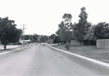
Photograph - SAILORS GULLY ROAD, 1995
... Black and white photrograph: residential street, 5 motor vehicles in middle distance. Noelene Wild 7.2000 ' photo, Peter Hyett, 1995, Sailors Gully Rd., from Kirkwood Road intersection, looking towards Darling St. intersection, Virginia Hill housing estate on right'...gully road Peter Hyett Black and white photrograph: residential street, 5 motor vehicles in middle distance. Noelene Wild 7.2000 ' photo, Peter Hyett, 1995, Sailors Gully Rd., from Kirkwood Road intersection, looking towards Darling St. intersection, Virginia Hill housing estate on right' Photograph SAILORS GULLY ROAD ...Black and white photrograph: residential street, 5 motor vehicles in middle distance. Noelene Wild 7.2000 ' photo, Peter Hyett, 1995, Sailors Gully Rd., from Kirkwood Road intersection, looking towards Darling St. intersection, Virginia Hill housing estate on right'Peter Hyettplace, streetscape, sailors gully road -
 Bendigo Historical Society Inc.
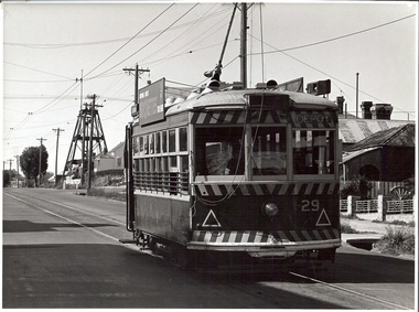
Photograph - BASIL MILLER COLLECTION: TRAMS
... Black and white photograph of 'Birney Car' Number 29 indicating 'Depot' in destination indicator. Heading uphill towards the poppet head of the 'Iron Bark Mine' in Long Gully. Inscription on reverse: Photo by A. Doney Bendigo stamped in blue. Birney car climbs the hill...Black and white photograph of 'Birney Car' Number 29 indicating 'Depot' in destination indicator. Heading uphill towards the poppet head of the 'Iron Bark Mine' in Long Gully. Inscription on reverse: Photo by A. Doney Bendigo stamped in blue. Birney car climbs the hill ...Black and white photograph of 'Birney Car' Number 29 indicating 'Depot' in destination indicator. Heading uphill towards the poppet head of the 'Iron Bark Mine' in Long Gully. Inscription on reverse: Photo by A. Doney Bendigo stamped in blue. Birney car climbs the hill past the the Iron Bark Mine.person, individual, basil miller -
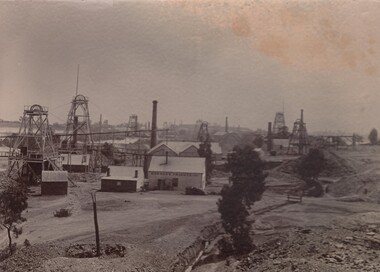 Bendigo Historical Society Inc.
Photograph - DUCHESS TRIBUTE MINE
... Black and white photograph: Gold mines, looking towards Snobs Hill. In the centre: Duchess Tribute Company of the Devonshire Mining Group. At least 8 poppet heads and 6 chimneys can be seen. The original is glued to cardboard. A copy of this photograph is in a black paper photo holder. On the back in pencil a sketch of where duchees tribute was located: between Alexander Street, Upper Road and Vinton Street, California Gully...Black and white photograph: Gold mines, looking towards Snobs Hill. In the centre: Duchess Tribute Company of the Devonshire Mining Group. At least 8 poppet heads and 6 chimneys can be seen. The original is glued to cardboard. A copy of this photograph is in a black paper photo holder. On the back in pencil a sketch of where duchees tribute was located: between Alexander Street, Upper Road and Vinton Street, California Gully ...Black and white photograph: Gold mines, looking towards Snobs Hill. In the centre: Duchess Tribute Company of the Devonshire Mining Group. At least 8 poppet heads and 6 chimneys can be seen. The original is glued to cardboard. A copy of this photograph is in a black paper photo holder. On the back in pencil a sketch of where duchees tribute was located: between Alexander Street, Upper Road and Vinton Street, California Gully.business, mining, duchess tribute -
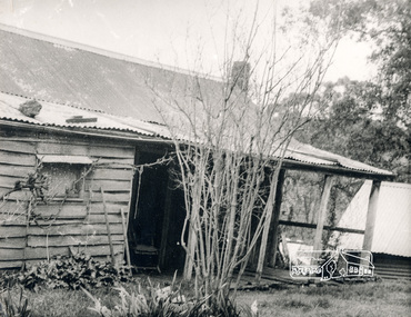 Eltham District Historical Society Inc
Photograph, George W. Bell, Detail, Cottage Entrance, Birch Cottage, Yarra Glen Road, Smiths Gully, Aug 1969, Aug 1969
... It included a video presentation on the history of the cottage under the title of "This Old House- Birch Cottage". houses cottage early settlers yarra glen road smiths gully williams cottage watsons creek christmas hills birch cottage edwin samuel birch honor mary birch Detail Cottage Entrance Williams Cottage Yarra Glen Rd Panton Hill Aug 1969 Photo - G.W.B Black and white photograph Detail, Cottage Entrance, Birch Cottage, Yarra Glen Road, Smiths Gully, Aug 1969 Photograph George W. ...EDHS Newsletter No. 182, September 2008 In the late 1970s when our Society was the Shire of Eltham Historical Society, an offer was made to the Society regarding use of an old cottage at Christmas Hills. For various reasons the offer ultimately lapsed The cottage sat beside Watsons Creek just outside the then Shire of Eltham but following municipal restructuring it now lies within the Shire of Nillumbik. At that time some research on the cottage was carried out for the Society by Keith Chappel as part of a larger research project that he was doing. Keith's notes were taken from Lands Department records and showed that house is the subject of a permissive occupancy of Crown land comprising the creek reserve. In 1903 a Miners Right of one acre in area was granted to Edwin Samuel Birch. In 1907 Birch applied to purchase this land but was unable to because it was part of the creek reserve. The documents show that the house existed at that time. Birch died in 1932 and his daughter Honor Mary Birch was granted a permit to occupy the residence. The future of the cottage remains precarious because of its location on Crown land. In 2007 the Andrew Ross Museum began a campaign to ensure that it is preserved. It included a video presentation on the history of the cottage under the title of "This Old House- Birch Cottage". Black and white photographDetail Cottage Entrance Williams Cottage Yarra Glen Rd Panton Hill Aug 1969 Photo - G.W.Bhouses, cottage, early settlers, yarra glen road, smiths gully, williams cottage, watsons creek, christmas hills, birch cottage, edwin samuel birch, honor mary birch -
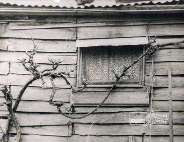 Eltham District Historical Society Inc
Photograph, George W. Bell, Detail, Front Wall, Birch Cottage, Yarra Glen Road, Smiths Gully, Aug 1969, Aug 1969
... It included a video presentation on the history of the cottage under the title of "This Old House- Birch Cottage". houses cottage early settlers yarra glen road smiths gully williams cottage watsons creek christmas hills birch cottage edwin samuel birch honor mary birch Detail of Front Wall Williams Cottage Yarra Glen Rd Panton Hill Aug 1969 Photo - G.W.B Black and white photograph Detail, Front Wall, Birch Cottage, Yarra Glen Road, Smiths Gully, Aug 1969 Photograph George W. ...EDHS Newsletter No. 182, September 2008 In the late 1970s when our Society was the Shire of Eltham Historical Society, an offer was made to the Society regarding use of an old cottage at Christmas Hills. For various reasons the offer ultimately lapsed The cottage sat beside Watsons Creek just outside the then Shire of Eltham but following municipal restructuring it now lies within the Shire of Nillumbik. At that time some research on the cottage was carried out for the Society by Keith Chappel as part of a larger research project that he was doing. Keith's notes were taken from Lands Department records and showed that house is the subject of a permissive occupancy of Crown land comprising the creek reserve. In 1903 a Miners Right of one acre in area was granted to Edwin Samuel Birch. In 1907 Birch applied to purchase this land but was unable to because it was part of the creek reserve. The documents show that the house existed at that time. Birch died in 1932 and his daughter Honor Mary Birch was granted a permit to occupy the residence. The future of the cottage remains precarious because of its location on Crown land. In 2007 the Andrew Ross Museum began a campaign to ensure that it is preserved. It included a video presentation on the history of the cottage under the title of "This Old House- Birch Cottage". Black and white photographDetail of Front Wall Williams Cottage Yarra Glen Rd Panton Hill Aug 1969 Photo - G.W.Bhouses, cottage, early settlers, yarra glen road, smiths gully, williams cottage, watsons creek, christmas hills, birch cottage, edwin samuel birch, honor mary birch -
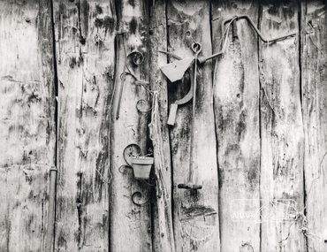 Eltham District Historical Society Inc
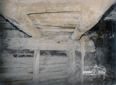
Photograph, George W. Bell, Detail, Shed Wall, Birch Cottage, Yarra Glen Road, Smiths Gully, Aug 1969, Aug 1969
... It included a video presentation on the history of the cottage under the title of "This Old House- Birch Cottage". houses cottage early settlers yarra glen road smiths gully williams cottage watsons creek christmas hills birch cottage edwin samuel birch honor mary birch Detail of Shed Wall Williams Cottage Yarra Glen Rd Panton Hill Aug 1969 Photo - G.W.B Black and white photograph Detail, Shed Wall, Birch Cottage, Yarra Glen Road, Smiths Gully, Aug 1969 Photograph George W. ...EDHS Newsletter No. 182, September 2008 In the late 1970s when our Society was the Shire of Eltham Historical Society, an offer was made to the Society regarding use of an old cottage at Christmas Hills. For various reasons the offer ultimately lapsed The cottage sat beside Watsons Creek just outside the then Shire of Eltham but following municipal restructuring it now lies within the Shire of Nillumbik. At that time some research on the cottage was carried out for the Society by Keith Chappel as part of a larger research project that he was doing. Keith's notes were taken from Lands Department records and showed that house is the subject of a permissive occupancy of Crown land comprising the creek reserve. In 1903 a Miners Right of one acre in area was granted to Edwin Samuel Birch. In 1907 Birch applied to purchase this land but was unable to because it was part of the creek reserve. The documents show that the house existed at that time. Birch died in 1932 and his daughter Honor Mary Birch was granted a permit to occupy the residence. The future of the cottage remains precarious because of its location on Crown land. In 2007 the Andrew Ross Museum began a campaign to ensure that it is preserved. It included a video presentation on the history of the cottage under the title of "This Old House- Birch Cottage". Black and white photographDetail of Shed Wall Williams Cottage Yarra Glen Rd Panton Hill Aug 1969 Photo - G.W.Bhouses, cottage, early settlers, yarra glen road, smiths gully, williams cottage, watsons creek, christmas hills, birch cottage, edwin samuel birch, honor mary birch -
 Eltham District Historical Society Inc
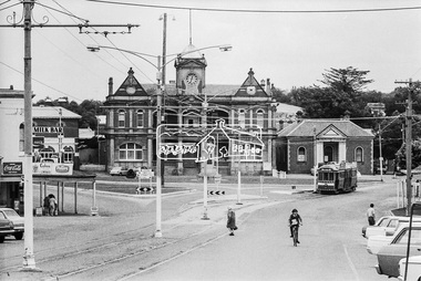
Photograph, Bendigo Tramways No. 2 en route to Quarry Hill outside Eaglehawk Town Hall, January 1972, Jan 1972
... Eltham District Historical Society Inc 728 Main Rd Eltham melbourne Viewed from High Street (Loddon Valley Highway) looking northwest from near Napier Street Bendigo, Bendigo Tramways No. 2, Eaglehawk, Eaglehawk Mechanics Institute, Eaglehawk Town Hall, George Coop Collection, High Street, Loddon Valley Highway, Milk bar, Quarry Hill, Sailors Gully Road, Tram Digital TIFF file Scan of 35mm Ilford FP3 black and white negative transparency Bendigo Tramways No. 2 en route to Quarry Hill outside Eaglehawk Town Hall, January 1972 Photograph George Coop George Coop ...Viewed from High Street (Loddon Valley Highway) looking northwest from near Napier StreetDigital TIFF file Scan of 35mm Ilford FP3 black and white negative transparencybendigo, bendigo tramways no. 2, eaglehawk, eaglehawk mechanics institute, eaglehawk town hall, george coop collection, high street, loddon valley highway, milk bar, quarry hill, sailors gully road, tram -
 Eltham District Historical Society Inc
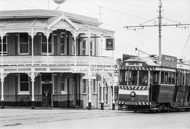
Photograph, Bendigo Tramways No. 2 en route from Quarry Hill outside the Victoria Hotel near the intersection of High Street at Victoria Street, Eaglehawk, January 1972, Jan 1972
... The Victoria Hotel is the present day New Victoria Hotel bendigo, bendigo tramways no. 2, eaglehawk, eaglehawk mechanics institute, eaglehawk town hall, george coop collection, high street, loddon valley highway, milk bar, street new victoria hotel, Pub, quarry hill, sailors gully road, tram, victoria hotel Digital TIFF file Scan of 35mm Ilford FP3 black and white negative transparency Bendigo Tramways No. 2 en route from Quarry Hill outside the Victoria Hotel near the intersection of High Street at Victoria Street, Eaglehawk, January 1972 Photograph George Coop George Coop ...Looking northwest across High Street, Eaglehawk at the intersection with Victoria Street. The Victoria Hotel is the present day New Victoria HotelDigital TIFF file Scan of 35mm Ilford FP3 black and white negative transparencybendigo, bendigo tramways no. 2, eaglehawk, eaglehawk mechanics institute, eaglehawk town hall, george coop collection, high street, loddon valley highway, milk bar, street new victoria hotel, pub, quarry hill, sailors gully road, tram, victoria hotel -
 Eltham District Historical Society Inc
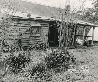
Photograph, George W. Bell, Birch Cottage, Yarra Glen Road, Smiths Gully, Aug 1969, Aug 1969
... It included a video presentation on the history of the cottage under the title of "This Old House- Birch Cottage". houses cottage early settlers yarra glen road smiths gully williams cottage watsons creek christmas hills birch cottage edwin samuel birch honor mary birch Williams Cottage Panton Hill 1969 Not to be reproduced without permission G.W. Bell Photographer Eltham Black ...EDHS Newsletter No. 182, September 2008 In the late 1970s when our Society was the Shire of Eltham Historical Society, an offer was made to the Society regarding use of an old cottage at Christmas Hills. For various reasons the offer ultimately lapsed The cottage sat beside Watsons Creek just outside the then Shire of Eltham but following municipal restructuring it now lies within the Shire of Nillumbik. At that time some research on the cottage was carried out for the Society by Keith Chappel as part of a larger research project that he was doing. Keith's notes were taken from Lands Department records and showed that house is the subject of a permissive occupancy of Crown land comprising the creek reserve. In 1903 a Miners Right of one acre in area was granted to Edwin Samuel Birch. In 1907 Birch applied to purchase this land but was unable to because it was part of the creek reserve. The documents show that the house existed at that time. Birch died in 1932 and his daughter Honor Mary Birch was granted a permit to occupy the residence. The future of the cottage remains precarious because of its location on Crown land. In 2007 the Andrew Ross Museum began a campaign to ensure that it is preserved. It included a video presentation on the history of the cottage under the title of "This Old House- Birch Cottage". Black and white photographWilliams Cottage Panton Hill 1969 Not to be reproduced without permission G.W. Bell Photographer Elthamhouses, cottage, early settlers, yarra glen road, smiths gully, williams cottage, watsons creek, christmas hills, birch cottage, edwin samuel birch, honor mary birch -
 Eltham District Historical Society Inc
Photograph, Long Gully Road Bridge, Panton Hill
... Eltham District Historical Society Inc 728 Main Rd Eltham melbourne infrastructure shire of eltham infrastructure Bridge Long Gully Road Bridge Panton Hill Black and white photograph Long Gully Road Bridge, Panton Hill Photograph ...Black and white photographinfrastructure, shire of eltham infrastructure, bridge, long gully road bridge, panton hill -
 Bendigo Historical Society Inc.
Photograph - Nell Gwynne Gold Mine site, 1934
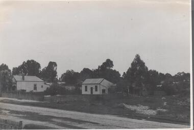
... Gully Water Reserve, north west of the reservoir near Diamond Hill Road. An abridged prospectus for the Nell Gwynne (B.M.L.) No Liability, was published in the Sun News Pictorial on 7th June 1934, page 26 (Advertising).https://trove.nla.gov.au/newspaper/article/277316940?searchTerm=napoleon%20bml Significant to mining history of Bendigo. Nell Gwynne Gold Mine Written in pencil on back of photograph in pencil: 'Nell Gwynne 25.9.34' Black ...The Nell Gwynne mine site was within the Spring Gully Water Reserve, north west of the reservoir near Diamond Hill Road. An abridged prospectus for the Nell Gwynne (B.M.L.) No Liability, was published in the Sun News Pictorial on 7th June 1934, page 26 (Advertising).https://trove.nla.gov.au/newspaper/article/277316940?searchTerm=napoleon%20bmlSignificant to mining history of Bendigo.Black and white photograph of two weatherboard houses in bush setting. Gravel road in foreground. Written in pencil on back of photograph in pencil: 'Nell Gwynne 25.9.34'nell gwynne gold mine -
 Bendigo Historical Society Inc.
Document - LONG GULLY HISTORY GROUP COLLECTION; GARDEN GULLY
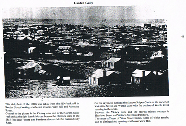
... History House 11 Mackenzie Street Bendigo goldfields BHS Collection BENDIGO History long gully history group The Long Gully History Group - Garden Gully Victory Mine Victory and Pandora Mine Knipes Castle View Hill Black and white photocopy of a photo titled Garden Gully, Photo taken in the 1880's. ...BHS CollectionBlack and white photocopy of a photo titled Garden Gully, Photo taken in the 1880's. There are a number of miners cottages in the photo. Knipes Castle is on the skyline. The Victory Mine and the chimney stack of the Victory and Pandora Mine can be seen.bendigo, history, long gully history group, the long gully history group - garden gully, victory mine, victory and pandora mine, knipes castle, view hill
