
Showing 44 items matching "bluff road"
-
 Melbourne Tram Museum
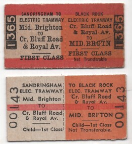
Ephemera - Tickets - Sandringham Tramway - Middle Brighton to Bluff Road and Royal Ave
... Tickets - Sandringham Tramway - Middle Brighton to Bluff Road and Royal Ave.......Bluff Road...Tickets were produced to enable first-class travel from Middle Brighton Railways station to Sandringham and then by Electric Tramway from Sandringham Railway Station to the corner of Bluff Road and Royal Ave. The ticket colours indicated to station staff, Inspectors, and conductors the nature of the ticket and its availability These tickets were purchased by the donor in 1970 long after the tramway had closed and travel classes were abolished on the suburban railways. ...Set of two Edmondson style card or pasteboard Victorian Railways return tickets for travel between Middle Brighton and Bluff Road and Royal Ave. Both date stamped 15 June 1970. .1 - Adult - 1st class - No. 1365 .2 - Child - 1st class - No. 00143...Yields information about the type of ticket that was issued to enable rail/tram travel on the Victorian Railways and their tramways. tramways trams tickets Victorian Railways Sandringham Black Rock Tramway Bluff Road Both date stamped on rear "!5 June 1970" Set of two Edmondson style card or pasteboard Victorian Railways return tickets for travel between Middle Brighton and Bluff Road and Royal Ave. ...Tickets were produced to enable first-class travel from Middle Brighton Railways station to Sandringham and then by Electric Tramway from Sandringham Railway Station to the corner of Bluff Road and Royal Ave. The ticket colours indicated to station staff, Inspectors, and conductors the nature of the ticket and its availability These tickets were purchased by the donor in 1970 long after the tramway had closed and travel classes were abolished on the suburban railways. They were available for use on the replacement bus service. Yields information about the type of ticket that was issued to enable rail/tram travel on the Victorian Railways and their tramways.Set of two Edmondson style card or pasteboard Victorian Railways return tickets for travel between Middle Brighton and Bluff Road and Royal Ave. Both date stamped 15 June 1970. .1 - Adult - 1st class - No. 1365 .2 - Child - 1st class - No. 00143Both date stamped on rear "!5 June 1970"tramways, trams, tickets, victorian railways, sandringham, black rock tramway, bluff road -
 City of Kingston
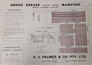
Pamphlet - Colour, Farrow Falcon Press, Printers, Ozone Estate, Bluff Road, Hampton, c.1940
... Ozone Estate, Bluff Road, Hampton...Sales plan for land in the suburb of Hampton (Highett), bounded by Bluff Road, Wickham Road, Peterson Street and June Street. ...Colour pamphlet advertising for private sale the Ozone Estate, Bluff Road Hampton. Incorporates a map of the estate bordered by Bluff Road, Wickham Road, June Street and Peterson Street including Morley Street, Follett Avenue and Parrett Street....Sales plan for land in the suburb of Hampton (Highett), bounded by Bluff Road, Wickham Road, Peterson Street and June Street. ...Sales plan for land in the suburb of Hampton (Highett), bounded by Bluff Road, Wickham Road, Peterson Street and June Street. Includes Morley Street, Follett Avenue, and Parrett StreetThe developing urban area of Highett within the City of Kingston. This land sale pamphlet illustrates the subdivision of land within the municipality and the changing demographic of the district as new houses are constructed close to infrastructure.Colour pamphlet advertising for private sale the Ozone Estate, Bluff Road Hampton. Incorporates a map of the estate bordered by Bluff Road, Wickham Road, June Street and Peterson Street including Morley Street, Follett Avenue and Parrett Street.Handwritten in grey pencil on reverse: Ozone Printed in purple ink on front top right-hand corner: Vendors are - Leslie Harcourt MacGowan, Esq / Neerim Road, Caulfield / & / Arthur Alfred Parrett, Esq / 311 Flinders Lane / Melbourneland sales, estate, hampton, highett -
 City of Kingston
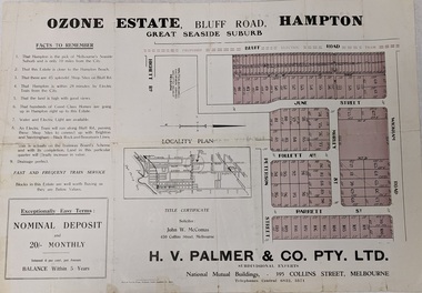
Pamphlet - Colour, Farrow Falcon Press, Printers, Ozone Estate, Bluff Road, Hampton, c. 1940
... Ozone Estate, Bluff Road, Hampton...Sales plan for land in the suburb of Hampton (Highett), bounded by Bluff Road, Wickham Road, Peterson Street and June Street. ...Colour pamphlet advertising for private sale the Ozone Estate, Bluff Road Hampton. Incorporates a map of the estate bordered by Bluff Road, Wickham Road, June Street and Peterson Street including Morley Street, Follett Avenue and Parrett Street....Sales plan for land in the suburb of Hampton (Highett), bounded by Bluff Road, Wickham Road, Peterson Street and June Street. ...Sales plan for land in the suburb of Hampton (Highett), bounded by Bluff Road, Wickham Road, Peterson Street and June Street. Includes Morley Street, Follett Avenue, and Parrett StreetThe developing urban area of Highett within the City of Kingston. This land sale pamphlet illustrates the subdivision of land within the municipality and the changing demographic of the district as new houses are constructed close to infrastructure.Colour pamphlet advertising for private sale the Ozone Estate, Bluff Road Hampton. Incorporates a map of the estate bordered by Bluff Road, Wickham Road, June Street and Peterson Street including Morley Street, Follett Avenue and Parrett Street.Handwritten in grey pencil on rear: Ozone Estateland sales, estate, highett, hampton -
 Melbourne Tram Museum
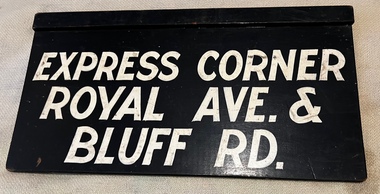
Sign - Auxiliary Destination Board - Sandringham - Royal Ave - Bluff Road, Victorian Railways (VR)
... Auxiliary Destination Board - Sandringham - Royal Ave - Bluff Road...Has been lettered on one side for "Express Corner Royal Ave & Bluff Road" and the other "Sandringham"...Sign Auxiliary Destination Board - Sandringham - Royal Ave - Bluff Road Victorian Railways (VR) ...Used as a destination or auxiliary board on Sandringham trams and buses that operated from the Sandringham railway station tram/bus depot. Tram and bus services were operated by the Victorian Railways. Has been lettered on one side for "Express Corner Royal Ave & Bluff Road" and the other "Sandringham"Demonstrates destination signs used by the Victorian Railways on their Sandringham services.Sign - plywood - 3 ply with a rebated timber section at the top of the sign, painted black with white letters. Two copies held.sandringham, vr trams, vr buses, signs, buses -
 Melbourne Tram Museum
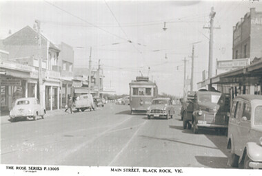
Postcard - Copy, Rose Stereograph Co, "Main Street Black Rock Vic", early to mid 1950s
... ...Bluff Road...Shows the tram terminus and the various shops on either side of Bluff Road....Shows the tram terminus and the various shops on either side of Bluff Road. Yields information about the Bluff Road tram terminus early to mid 1950s. ...Rose Series postcard P 13005, of VR Tram No. 50 at the Black Rock terminus in Bluff Road, titled "Main Street Black Rock Vic". Shows the tram terminus and the various shops on either side of Bluff Road.Yields information about the Bluff Road tram terminus early to mid 1950s.Copy photograph - of a Rose Series postcardmelbourne, rose series, black rock, bluff road, vr trams, tram 50 -
 Melbourne Tram Museum
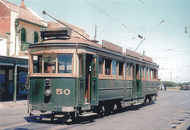
Photograph - VR tram 50 at the Black Rock terminus, Noel Reed, mid 1950s
... ...Bluff Road...Colour photograph of VR tram 50 at the Bluff Road terminus of the Sandringham to Black Rock route which closed in November 1956. ...Colour photograph of VR tram 50 at the Bluff Road terminus of the Sandringham to Black Rock route which closed in November 1956. ...Colour photograph of VR tram 50 at the Bluff Road terminus of the Sandringham to Black Rock route which closed in November 1956. Photo possibly mid 1950s, photographer Noel ReedYields information about VR tram No 50 at the Black Rock terminus.Colour photograph with printers details on the rear.vr, vr class tramcars, sandringham to black rock, black rock, bluff road, tram 50 -
 City of Kingston
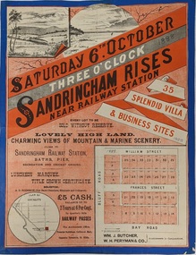
Pamphlet - Colour, Fergusson & Mitchell Lith, Sandringham Rises, c. 1888
... Sales plan for land in the suburb of Sandringham, bounded by Bluff Road, Bay Road and William Street, and incorporating Frances Street....Incorporates a map of the estate bordered by Bluff Road, Bay Road and William Street, including Frances Street....Incorporates a map of the estate bordered by Bluff Road, Bay Road and William Street, including Frances Street. ...Sales plan for land in the suburb of Sandringham, bounded by Bluff Road, Bay Road and William Street, and incorporating Frances Street.The developing urban area of Highett (then called Sandringham) within the City of Kingston. This land sale pamphlet illustrates the subdivision of land within the municipality and the changing demographic of the district as new houses are constructed close to infrastructure.Colour pamphlet advertising for sale 35 lots in Sandringham Rises, Sandringham. Incorporates a map of the estate bordered by Bluff Road, Bay Road and William Street, including Frances Street.Handwritten in grey pencil next to the words 'THREE O'CLOCK': 1888 Handwritten in blue ben next to the words '& BUSINESS SITES': 1888land sales, sandringham, highett -
 Melbourne Tram Museum
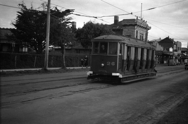
Negative, Wal Jack, c1946
... ... Bluff Road...Black and white negative, of Victorian Railways trams 26 in Bluff Road, Black Rock Note the white bumper bars. ...Trams tramways Victorian Railways VR Trams Bluff Road Black Rock tram 26 Black and white negative, of Victorian Railways trams 26 in Bluff Road, Black Rock Note the white bumper bars. ...Black and white negative, of Victorian Railways trams 26 in Bluff Road, Black Rock Note the white bumper bars. Photo c1946. (Possibly 12-3-1946 - see Reg Item 5773) In the background is State Savings Bank Photo not in the Wal Jack Victorian Railways Album.trams, tramways, victorian railways, vr trams, bluff road, black rock, tram 26 -
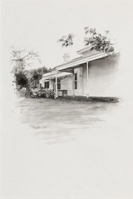 Bayside Gallery - Bayside City Council Art & Heritage Collection
Work on paper - ink and watercolour, Annette Meikle, Shenval, 1977
... ...Bluff Road...Built in 1891 for Captain Murray to his own design, ‘Shenval’ originally stood on five acres fronting Bluff Road, Black Rock....Built in 1891 for Captain Murray to his own design, ‘Shenval’ originally stood on five acres fronting Bluff Road, Black Rock. annette meikle sandringham sketchbook elizabeth waters black rock architecture historic house Shenval Captain Murray Bluff Road verandah Shenval Work on paper ink and watercolour Annette Meikle ...In 1977, artist Annette Meikle undertook a commission to illustrate a book recording stories of places and people in the Bayside area. It was published in 1978 as Sandringham Sketchbook, with text by Elizabeth Waters. The sketches were intended to record remaining examples of Bayside’s early architecture and environment, as well as reflect newer architectural changes. Meikle went on to donate 22 of these sketches to Bayside City Council in 2003. Built in 1891 for Captain Murray to his own design, ‘Shenval’ originally stood on five acres fronting Bluff Road, Black Rock.Annette Meikle, Shenval 1977, ink and watercolour, 33 x 23.5 cm. Bayside City Council Art and Heritage Collection. Donated by the artist, 2003annette meikle, sandringham sketchbook, elizabeth waters, black rock, architecture, historic house, shenval, captain murray, bluff road, verandah -
 Alfred Health (The Alfred, Caulfield Hospital, and Sandringham Hospital)
Book, A most ingenious hospital a history of Sandringham and District Memorial Hospital 1940-1990, 1990
... 193 Bluff Road Sandringham, Victoria ...Book documenting the efforts to establish and build the Sandringham and District Memorial Hospital Book documents history leading to construction of Sandringham and District Memorial Hospital Hard cover book A most ingenious hospital a history of Sandringham and District Memorial Hospital 1940-1990 by Harry W NunnNilsandringham and district memorial hospital., sandringham and district memorial hospital -- history., hospitals, public -- history -- victoria., hospitals -- victoria -- sandringham region -- history., victoria, maternity, medical treatment, research and training -
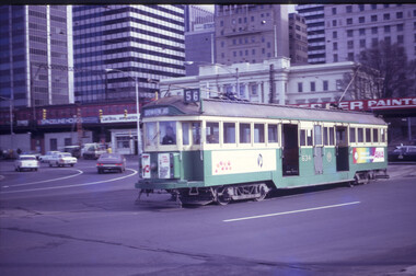 Melbourne Tram Museum
Slide - MMTB, VR and MTA tramway operations set of 11, Hugh Ballment, 1950s to 1990s
... ...Bluff Road...In the background is Bluff Road Audio, advertising Astor Radio and J Boyd Robinson Tested. ...In the background is Bluff Road Audio, advertising Astor Radio and J Boyd Robinson Tested. ...Set of 11 photos by Hugh Ballment, unless noted, of MMTB, VR, and MTA: HBM162 - MMTB W2 634, 1970s, Queensbridge, running a Domain Road Route 56 with a Tait set on the viaduct and the city skyline. HBM163 - MMTB, cMay 1968, St Kilda Junction, Construction of Queensway, showing a temporary bridge. W2 on route 4D HBM164 - MTA B1 2055, Route 59. Z3 162, Route 57. cNov1997, Elizabeth St terminus, showing the Sir Robert Risson Tram terminus structure, Flinders Street Railway station, and the Herald & Weekly Times and the IBM buildings across the Yarra River. HBM165 - MMTB Y1 613, 17/07/1957, Camberwell Depot, Night pic interior. Photo by Keith Kings HBM166 - MMTB Y1 611, 17/07/1957, Camberwell Depot. Photo by Keith Kings, Night pic interior HBM167 - MMTB Y 612, 1960s, Batman Avenue, running a Burwood service. A W2 is in front of the 612. HBM168 - VR No 41 entering the Broadway from Ormond Road while MMTB SW6 953 class waits to complete it journey to Point Ormond along Glen Huntly Road. 1950s, HBM169 - MMTB X2 679, 8/03/1957, Footscray Depot. Several X1 cars on the left. A Ford bus No 476 is on the right. This vehicle was retired and officially out of use at the time. Photo by Keith Kings, HBM170 - VR Tram 51, 26/05/1954, Bluff Road Black Rock, Terminus, Tram has departed for Sandringham. See image HBM154 as well. In the background is Bluff Road Audio, advertising Astor Radio and J Boyd Robinson Tested. The tram is showing the destination of Sandringham HBM171 - VR Tram 48, 26/05/1954, Station St Sandringham, arriving at the station terminus with a Ladies Hairdresser shop in the background. HBM172 - MTA A 263, cNov 1997, Spencer Street and Flinders Street intersection, with a ComEng train on viaduct. Tram is running a Port Melbourne route 109 service. Yields information about Melbourne tram operations, with 1950s to 1990s photos of Melbourne tramways.Kodachrome cardboard and plastic mounts, with notes - set of 11new tramway, tram 634, queensbridge, st kilda junction, tram 162, elizabeth st, tram 41, tram 2055, tram 613, tram 611, glen huntly road, vr, st kilda brighton tramway, broadway, tram 679, footscray depot, trams, w2 class, sw6 class, x2 class, a class, b class, y1 class, z3 class, tram 612, tram 953, x1 class, route 56, route 4d, route 59, route 57, batman avenue, camberwell depot, interiors, mmtb buses, bus 476, ford motor company, sandringham, black rock, bluff road, tram 51, tram 48, sandringham to black rock, tram 263, route 109, flinders st, spencer st, ormond road -
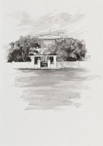 Bayside Gallery - Bayside City Council Art & Heritage Collection
Work on paper - ink and watercolour, Annette Meikle, Karinga, 1977
... ...Bluff Road...This inter-war house located at 60 Bluff Road, Black Rock, was built in 1926 for former Scotland Yard and Criminal Investigation Branch detective Horatio Reginald Clarence McWilliams. ...This inter-war house located at 60 Bluff Road, Black Rock, was built in 1926 for former Scotland Yard and Criminal Investigation Branch detective Horatio Reginald Clarence McWilliams. ...In 1977, artist Annette Meikle undertook a commission to illustrate a book recording stories of places and people in the Bayside area. It was published in 1978 as Sandringham Sketchbook, with text by Elizabeth Waters. The sketches were intended to record remaining examples of Bayside’s early architecture and environment, as well as reflect newer architectural changes. Meikle went on to donate 22 of these sketches to Bayside City Council in 2003. This inter-war house located at 60 Bluff Road, Black Rock, was built in 1926 for former Scotland Yard and Criminal Investigation Branch detective Horatio Reginald Clarence McWilliams. When McWilliams died it was found that he had taken extreme measures to protect his security. All the windows were nailed shut, a network of burglar alarms ran through the house and a complicated underground air raid shelter had been built in the garden. The security measures were at odds with the name of the house – Karinga or Karinya – an Aboriginal word meaning peaceful, happy home. Later residents of ‘Karinga’ included Senator Don Chipp and his family. The property has since been demolished and apartments have been built on the land.Annette Meikle, Karinga 1977, ink and watercolour, 32 x 23.5 cm. Bayside City Council Art and Heritage Collection. Donated by the artist, 2003annette meikle, sandringham sketchbook, elizabeth waters, black rock, karinga, karinya, horatio reginald clarence mcwilliams, senator don chipp, historic house, bluff road -
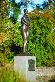 Bayside Gallery - Bayside City Council Art & Heritage Collection
Sculpture, Guy Boyd, The swimmer, 1988
... ...Bluff Road...sculpture swimmer female figure guy boyd public art bayside bayside city council australian bicentennial project guy martin à beckett boyd bronze city of Sandringham Indigenous Resource Garden Bluff Road Sandringham bronze The swimmer Sculpture sculpture Guy Boyd ...bronzesculpture, swimmer, female, figure, guy boyd, public art, bayside, bayside city council, australian bicentennial project, guy martin à beckett boyd, bronze, city of sandringham, indigenous resource garden, bluff road, sandringham -
Glenelg Shire Council Cultural Collection
Photograph - Photograph - Dutton Way, n.d
... Dutton Way looking towards Whalers Bluff, road with fence above beach and a horse tied up to post....Dutton Way looking towards Whalers Bluff, road with fence above beach and a horse tied up to post. ...Black and white photo taken from glass plate negative, attached to heavy card. Dutton Way looking towards Whalers Bluff, road with fence above beach and a horse tied up to post.Front: 'Dutton Way 1900' - black texta -
 St Kilda Historical Society
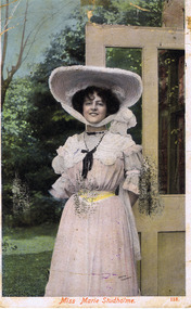
Photograph, Miss Marie Studholme
... Miss D Taffett, Bluff Road, Elwood....Miss D Taffett, Bluff Road, Elwood. tinted colour postcard, unmounted, original, fair condition Miss Marie Studholme Photograph ...tinted colour postcard, unmounted, original, fair conditionOn back: Dear Dorothy I shall be with you as usual tomorrow (Tues) at half past 4 oc. Hoping you are all well. Miss D Taffett, Bluff Road, Elwood. -
 Halls Gap & Grampians Historical Society
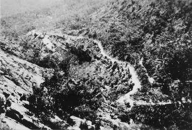
Photograph - Sepia, C 1930s
... The Mt Victory Rd was originally called the Bluff Road After improvements and extension it was renamed at its opening by Lady Somers in Mar 1930...The Mt Victory Rd was originally called the Bluff Road After improvements and extension it was renamed at its opening by Lady Somers in Mar 1930 ACCESS ROUTES Roads Photo shows the newly formed Mt Victory Rd. with the bridle track above it Photo taken from the top of the Elephant's hide Photograph Sepia ...The Mt Victory Rd was originally called the Bluff Road After improvements and extension it was renamed at its opening by Lady Somers in Mar 1930Photo shows the newly formed Mt Victory Rd. with the bridle track above it Photo taken from the top of the Elephant's hideaccess routes, roads -
 Halls Gap & Grampians Historical Society
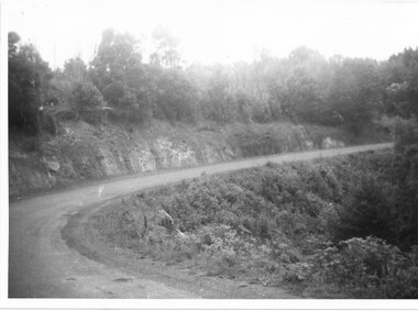
Photograph - B/W, C 1930s-1940s
... Mt Victory Rd once known as the Bluff road was opened by Lady Somers Mar 1930. ...Mt Victory Rd once known as the Bluff road was opened by Lady Somers Mar 1930. ...Mt Victory Rd once known as the Bluff road was opened by Lady Somers Mar 1930. This section of the raod is beyond Stoney Creek Gorgephoto shows sweeping bend on Mt Victory Rdaccess routes, mt victory rd, roads -
 Melbourne Tram Museum
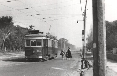
Photograph - VR Tram 51 Royal Avenue Sandringham, K McCarthy, 4-9-1956
... The photograph shows VR tram No. 51 in Royal Avenue at the corner with Bluff Road. There is a lady and two children walking towards the tram. ...The photograph shows VR tram No. 51 in Royal Avenue at the corner with Bluff Road. There is a lady and two children walking towards the tram. ...The photograph shows VR tram No. 51 in Royal Avenue at the corner with Bluff Road. There is a lady and two children walking towards the tram. Note the tram stop signage on the pole alongside the tram. Photo by Ken McCarthy, 4-9-1956.Yields information about the VR tram 51 and Royal Ave during 1956.Black and white photograph with notes on the rear.In ink "40 return to K.McC, 4-9-56" and label with "Photo page 7, Same size"tramways, tramcars, vr, vr trams, sandringham, royal ave -
 Halls Gap & Grampians Historical Society
Photograph - B/W, C 1920s
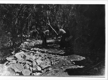
... Increased traffic lead to much of this route being widened into what became known as Bluff Road. Within a few years the route was further improved and was officially named Mount Victory Road in 1930....Increased traffic lead to much of this route being widened into what became known as Bluff Road. Within a few years the route was further improved and was officially named Mount Victory Road in 1930. ...Men have started to form the Mt Victory Road. Until the 1900's access to the Stoney Creek gorge was via a winding bridal jinker track. Increased traffic lead to much of this route being widened into what became known as Bluff Road. Within a few years the route was further improved and was officially named Mount Victory Road in 1930.Photo shows 3 men working with pick and shovel on roadPick and shovel Mt Victory Rdaccess routes, roads, access routes, road building -
 Brighton Historical Society
Shoes, 1850s
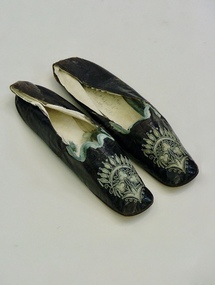
... From 1856 until 1931 the Smiths lived at 'Castlefield', a mansion on a vast estate that at one time stretched along South Road from Bluff Road to Hampton Street. The land was gradually subdivided, and the house is now a part of Haileybury College....From 1856 until 1931 the Smiths lived at 'Castlefield', a mansion on a vast estate that at one time stretched along South Road from Bluff Road to Hampton Street. The land was gradually subdivided, and the house is now a part of Haileybury College. shoes embroidery applique castlefield emily smith brighton Pair of flat black kid leather indoor shoes decorated with pale blue silk, cut-away applique and embroidery. ...These shoes were worn by Emily Cock (nee Smith), the daughter of wealthy early settler John Matthew Smith. From 1856 until 1931 the Smiths lived at 'Castlefield', a mansion on a vast estate that at one time stretched along South Road from Bluff Road to Hampton Street. The land was gradually subdivided, and the house is now a part of Haileybury College.Pair of flat black kid leather indoor shoes decorated with pale blue silk, cut-away applique and embroidery.shoes, embroidery, applique, castlefield, emily smith, brighton -
 City of Moorabbin Historical Society (Operating the Box Cottage Museum)
Clothing - Clothing, City of Moorabbin Tie, Circa 1960s
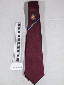
... In 1934 The City of Moorabbin was established for the area from South East corner of Thomas Street and North Road , East to Warrigal Road, Clayton Road, Kingston Road , Lower Dandenong Road, then South along Nepean Highway to Balcombe Road and along Bluff Road, Cummins Road, Nepean Highway, Thomas Street to North Road In the 1994 Amalgamation of Councils the City of Moorabbin was divided between the new City of Kingston in the South ( from South Road) and the new City of Glen Eira to the North . ...In 1934 The City of Moorabbin was established for the area from South East corner of Thomas Street and North Road , East to Warrigal Road, Clayton Road, Kingston Road , Lower Dandenong Road, then South along Nepean Highway to Balcombe Road and along Bluff Road, Cummins Road, Nepean Highway, Thomas Street to North Road In the 1994 Amalgamation of Councils the City of Moorabbin was divided between the new City of Kingston in the South ( from South Road) and the new City of Glen Eira to the North . ...The City of Moorabbin existed from 1934 until 1994. Henry Dendy's Special Survey in 1841 of 5,120 acres in the Parish of Moorabbin , extended from Port Phillip Bay , then East to Boundary Road, South to South Road and North to North Road and became known as Brighton. 1859 Brighton became a Borough with its boundary Thomas Street ,and Bluff Road. In 1862 The Moorabbin Roads Board was formed and the extended area now included Cheltenham, Hampton, Sandringham, Black Rock, Beaumaris, Mentone and Mordialloc .and Little Brighton became known as Bentleigh. In 1871 the area became known as The Shire of Moorabbin. Gradually the area was separated into The Borough of Sandringham 1917, ( Black Rock, Beaumaris , Sandringham and Hampton ) Borough of Mentone and Mordialloc 1920, ( Parkdale ). In 1934 The City of Moorabbin was established for the area from South East corner of Thomas Street and North Road , East to Warrigal Road, Clayton Road, Kingston Road , Lower Dandenong Road, then South along Nepean Highway to Balcombe Road and along Bluff Road, Cummins Road, Nepean Highway, Thomas Street to North Road In the 1994 Amalgamation of Councils the City of Moorabbin was divided between the new City of Kingston in the South ( from South Road) and the new City of Glen Eira to the North . It was the largest Municipality in Victoria with a population of 118,865 in 1974This tie c 1960 is a memento of the City of Moorabbin 1934 - 1994Maroon colour, polyester, man's tie with the crest of City of Moorabbin woven on front.around circle enclosing Coat of Arms ; CITY OF MOORABBIN city of moorabbin, moorabbin roads board, moorabbin, brighton, dendy's special survey 1841, early settlers, pioneers, market gardners, dendy henry, were jonathan b, cheltenham, bentleigh, mentone, sandringham, mair william, bent thomas -
 Brighton Historical Society
Shoes, circa 1867
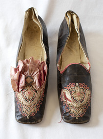
... From 1856 until 1931 the Smiths lived at 'Castlefield', a mansion on a vast estate that at one time stretched along South Road from Bluff Road to Hampton Street. The land was gradually subdivided, and the house is now a part of Haileybury College. ...From 1856 until 1931 the Smiths lived at 'Castlefield', a mansion on a vast estate that at one time stretched along South Road from Bluff Road to Hampton Street. The land was gradually subdivided, and the house is now a part of Haileybury College. ...These shoes were worn by Emily Cock (nee Smith), the daughter of wealthy early settler John Matthew Smith. From 1856 until 1931 the Smiths lived at 'Castlefield', a mansion on a vast estate that at one time stretched along South Road from Bluff Road to Hampton Street. The land was gradually subdivided, and the house is now a part of Haileybury College. Julien Mayer was a French ladies shoemaker and prolific exporter who advertised his successes on the shoes themselves by stamping the soles with details of the prizes he had won.Pair of black kid leather shoes with low block heel, decorated with pink silk, cut-away applique and embroidery. Pink bow with metal clasp on one shoe; missing from the other. Edged with pink silk ribbon binding, largely deteriorated.Sole embossed with "MAYER / Julien / à Paris", in addition to tamped with three small medallions proclaiming the awards the shoemaker won in London in 1862, Porto in 1865 and Paris in 1867. Handwritten in interior sole of T0124.2 in pencil: "Emily Smith / Castlefield"emily smith, castlefield, shoes, 1860s, applique, embroidery, julien mayer -
 Melbourne Tram Museum
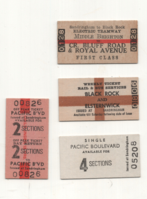
Ephemera - Sandringham - rail - tram - bus tickets - set of 4, Victorian Railways (VR), 1950s to 1980s
... This set of tickets represents samples of Edmondson-style tickets sold at stations for use on the bus. 1 - Middle Brighton to Cnr of Bluff Road & Royal Ave - first class - joint rail and tram tickets - No. 0128 - dated stamped 15 June 1971 (this ticket was purchased by the donor as a sample at the time) 2 - Weekly ticket - Black Rock and Elsternwick - issued at Sandrinham - No. 0809 3 - Single ticket - 4 sections - Pacific Boulevard - No. 05208 4 - Return ticket - 2 sections - day return - Pacific Boulevard - No, 00826 ...This set of tickets represents samples of Edmondson-style tickets sold at stations for use on the bus. 1 - Middle Brighton to Cnr of Bluff Road & Royal Ave - first class - joint rail and tram tickets - No. 0128 - dated stamped 15 June 1971 (this ticket was purchased by the donor as a sample at the time) 2 - Weekly ticket - Black Rock and Elsternwick - issued at Sandrinham - No. 0809 3 - Single ticket - 4 sections - Pacific Boulevard - No. 05208 4 - Return ticket - 2 sections - day return - Pacific Boulevard - No, 00826 Demonstrates a railway ticketting system that was used on buses and railways Railways tickets weekly tickets buses Victorian Railways Sandringham Sandringham to Black Rock Pacific Boulevard Set of 4 Edmondson style railway tickets. ...The Victorian Railways continued to operate a bus service along the former Black Rock - Sandringham line, long after the tram line closed. This set of tickets represents samples of Edmondson-style tickets sold at stations for use on the bus. 1 - Middle Brighton to Cnr of Bluff Road & Royal Ave - first class - joint rail and tram tickets - No. 0128 - dated stamped 15 June 1971 (this ticket was purchased by the donor as a sample at the time) 2 - Weekly ticket - Black Rock and Elsternwick - issued at Sandrinham - No. 0809 3 - Single ticket - 4 sections - Pacific Boulevard - No. 05208 4 - Return ticket - 2 sections - day return - Pacific Boulevard - No, 00826 Demonstrates a railway ticketting system that was used on buses and railwaysSet of 4 Edmondson style railway tickets.railways, tickets, weekly tickets, buses, victorian railways, sandringham, sandringham to black rock, pacific boulevard -
 Melbourne Tram Museum
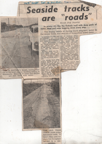
Newspaper - and photographs, Herald Sun, "Seaside tracks are "roads"", 1955
... Photo 1 - print of the photo used - has notes on the rear - and Herald Sun stamp Photo 2 - 'Bluff Road, up track inside raill'...Photo 1 - print of the photo used - has notes on the rear - and Herald Sun stamp Photo 2 - 'Bluff Road, up track inside raill' Yields information about the road condition in the Beaumaris area in 1955. ...The article and photo report on the poor condition of roads in particular Hayden's Road and the former, short lived Victorian Railways Beaumaris - Black Rock tram line. Has two photos showing the road condition. The second photo shows sleepers from the former tram line and a badly worn road surface that had been placed on top. The item by a staff reporter likens the road to wartime battle fields. The tram line rails were lifted or removed during 1939 - see page 35 of The Brighton Electric Line. Photo 1 - print of the photo used - has notes on the rear - and Herald Sun stamp Photo 2 - 'Bluff Road, up track inside raill'Yields information about the road condition in the Beaumaris area in 1955.Newspaper clipping titled - "Seaside tracks are "roads"" - Melbourne Herald 12/11/1955 and set of two photographs."Melb "Herald" Sat 12 Nov 1955"trams, tramways, vr trams, track maintenance, tram tracks, beaumaris -
 Melbourne Tram Museum
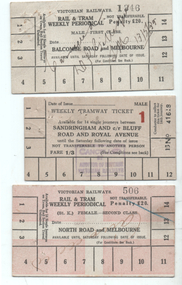
Ephemera - Rail & Tram weekly tickets, Victorian Railways (VR), c1935
... All tickets were available for 14 tram trips only, but unlimited rail trips: 1 - Balcombe Road and Melbourne - First Class - white card - No. 1346, marked cancelled 13/5/1939 2 - Sandringham and cnr Bluff Road and Royal Ave - white card - Male, No. 41618, price 1/3 with a red 1 (first class?) ...All tickets were available for 14 tram trips only, but unlimited rail trips: 1 - Balcombe Road and Melbourne - First Class - white card - No. 1346, marked cancelled 13/5/1939 2 - Sandringham and cnr Bluff Road and Royal Ave - white card - Male, No. 41618, price 1/3 with a red 1 (first class?) ...Set of three Victorian Railways Rail & Tram weekly Periodicals with conditions of travel on the rear, See reference page 124 and Figure 6-27. Such tickets were introduced on 1/7/1939. All tickets were available for 14 tram trips only, but unlimited rail trips: 1 - Balcombe Road and Melbourne - First Class - white card - No. 1346, marked cancelled 13/5/1939 2 - Sandringham and cnr Bluff Road and Royal Ave - white card - Male, No. 41618, price 1/3 with a red 1 (first class?) - stamped cancelled 3 - North Road and Melbourne - white card overprinted in pink to leave a cross, Female, No. 506, Second class, with cancelled hand written on the front.Demonstrates a Victorian Railways Rail and Tram weekly tickets for both their tramways and the changes made over time. May have been used for training samples.Set of three printed card tickets with over printing and hand writing as shown.tickets, vr, vr trams, victorian railways, st kilda brighton tramway, weekly tickets, sandringham to black rock -
 Orbost & District Historical Society
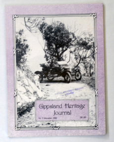
book, E-Gee Printers Pty Ltd, Gippsland Heritage Journal, December 1990
... The front cover ismauve with a b/w photograph of a model T ford at Arnott's Bluff on the Licola Road near Burgoyne's Gap. The magazine contains photographs, articles on the history of Gippsland....The front cover ismauve with a b/w photograph of a model T ford at Arnott's Bluff on the Licola Road near Burgoyne's Gap. The magazine contains photographs, articles on the history of Gippsland. ...Gippsland Heritage Journal is a journal, produced about every nine - twelve months, for those interested in regional, local and family history in Gippsland, Victoria, Australia. It is compiled by Meredith Fletcher, Debbie Squires and Linda Barraclough and includes a diverse range of articles, both academic and non-academic. Since No.24 it has been a partially refereed journal. This copy was used in the library of Orbost Secondary College. This item is a useful reference tool on the history of Gippsland.A 64 pp magazine, titled Gippsland Heritage Journal No 9 (December 1990). It cost $6.00. The front cover ismauve with a b/w photograph of a model T ford at Arnott's Bluff on the Licola Road near Burgoyne's Gap. The magazine contains photographs, articles on the history of Gippsland.book-gippsland-heritage-journal gippsland-history -
 Halls Gap & Grampians Historical Society
Map - Coloured
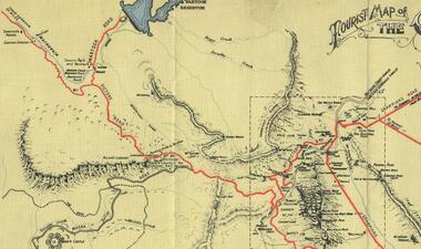
... To this end, the Bluff Road was improved and extended on 1929 and at its opening in March, 1930, by Lady Somers it was renamed the Mt. ...To this end, the Bluff Road was improved and extended on 1929 and at its opening in March, 1930, by Lady Somers it was renamed the Mt. ...Background on Bridle Path up Stony Creek Gorge Pre 1840 C. B. Hall, squatter on Mokepilly Run 1841-1842, first European to discover the Fyans Creek valley, the entrance of which became known as Hall's Gap. He later recorded that he followed a number of tracks which he assumed had been made by the Aboriginies and described one as "leading up a wild romantic glen and over on to the source of the Glenelg River". This could well have been the route taken up Stony Creek gorge by the first timber-cutters in this part of the Grampians to the saddle between the Wonderland and Mt. Difficult ranges known as Valley Gap 1850s/60s Timber cutters and shingle splitters were reported to be moving into the eastern side of the Grampians and by the mid 1860s there were a number of families connected to the supplying of timber to Pleasant Creek living in the "Hall's Gap ranges". John Wakeham, the first store owner in Pleasant Creek in 1854, established a timer-mill in upper Stony Creek Gorge in the late 1850s. Wakeham is credited for the clearing and levelling of the first bridle-path up the gorge. 1870s By the mid 1870s the track had been extended over Valley Gap to the Victoria Forest (the upper region of the Victoria Valley). McKeon's bullock team was known to have hauled red gum from the Valley to Stawell in the late 1870s and the 1880s. 1880s In 1887 an article in the Pleasant Creek news describes the Stony Creek Gorge track as "being a ledge alongside the mountain range, formed in the early days with the aid of earth and timber, along which the bullock teams used to travel to Horsham and plains of the Wimmera beyond." 1890s Gold was discovered in the catchment area of Stony Creek and by the end of the 1890s a new track was built from "near the junction of Fyan's and Stony Creeks, up the gorge to the diggings settlement. The mining Department had paid L300 for its construction and, when completed, the track was "three miles and 30 chains in length, the side cuttings at the narrowest part being 10 feet between" and "the watercourses which cross the track at various points" having been "filled up with rocks rolled down the sides of the hills, and consequently there can be no damage caused by bushfires which destroyed the former wooden bridges erected on the old track to Wakeham's saw-mill, the remains of which are still to be seen at the side of the diggings" The article goes on to further describe the track as one which "can with ease travel with a two horse conveyance either up or down" and that the workmen engaged in the construction of the track would be attending "a ball that night at McKeon's farm near the mouth of the gap to celebrate the successful completion of the undertaking". 1900s At what time the bridle path was extended beyond Valley Gap to the Wartook basin on the Mt. Difficult Range has not yet been determined. However, it is known that, by the turn of the century, people were travelling between Halls Gap and the caretakers' residence at Wartook Reservoir along what was now known as the "Bluff Road. Wartook's embankment had been constructed in 1887 and at that time there was already a track from Rosebrook Station homestead (near the present day Wartook Pottery) to the reservoir. Philip Rose owned both Rosebrook and Wartook Stations from the mid 1840s to the late 1850s and had regularly leased the Wartook basin to Cobb & Co. to rest horses there. 1920s Following the war of 1914-1918, tourism really took off in the Grampians, and Halls Gap rapidly grew. People would travel as far as they could on the many tracks then hike to the many lookouts being discovered by local tour guides. This led to the need for access across the range so that horse riders and the increasing number of vehicles could travel between Horsham and Halls Gap. To this end, the Bluff Road was improved and extended on 1929 and at its opening in March, 1930, by Lady Somers it was renamed the Mt. Victory Road.Map of Mt Victory Road and othersaccess routes, mt victory rd, bridle path, roads -
 Federation University Historical Collection
Document, Ken Clements, Peterborough Puzzles, 2009, 2009
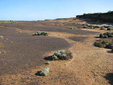
... Massacre Bay is located on Victoria's Great Ocean Road, and is in the centre of the Bay of Martyrs. The bay consists of 20 m high, red limestone bluffs. ...Massacre Bay is located on Victoria's Great Ocean Road, and is in the centre of the Bay of Martyrs. The bay consists of 20 m high, red limestone bluffs. ...Massacre Bay is located on Victoria's Great Ocean Road, and is in the centre of the Bay of Martyrs. The bay consists of 20 m high, red limestone bluffs. This paper by Ken Clements considers the origin of the term martyr in connection to this location, and where the Aboriginal massacre may have taken place. Thirteen page document by Ken Clements relating to Peterborough, Victoria. Contents include coastal features, local Aborigines, Bay of Martyrs, Massacre Bay, Massacre Hill, Buckley Creek Run, Pioneer Pastoralists, British Traversers, settlers, Peterborough, Maps, tourism, history method. Photographs by Laurie Moore.aborigines, bay of martyrs, massacre bay, massacre hill, buckley creek run, pioneer pastoralists, british traversers, settlers, peterborough, maps, tourism, history method, childers cove, barque children, murnane bay, sandy bay, dog trap bay, buckley creek, viviennes lookeout, stanhope bay, buttres bay, burnies beach, armstrong creek, flaxman hill, antares rock, lovers nook, crofts bay, clements, worm bay, halladale point, the well, wold dog cove, james irvine monument, curdies inlet, squirrel creek, wallaby creek, boggy creek, whiskey creek, pioneer beach, schomberg rock, young australia, spit, crown of thorns, newfield bay, the grotto, london bridge, point hesse, high cliffs, the arch, cape martyr, little massacre bay, aboriginal massacre, ken clements -
Federation University Historical Collection
Reports, Big Cats Sightings and Stock Kills 2000-2011, 2000-2011
... bluff...binginnwarri...dawson...the springs...mt taylor...black range...driffield west...Snowy plains airstrip...glenmaggie north...jack smith lake...munro...briagaling...dutson downs...connors plain...giffard west...darriment...Joyces Road...The folder was collected for research being conducted by David Waldron. australian mythical animals collection david waldron Department of Primary Industries rangers peter walsh Warragul creek Binginwarri Coongulla Straford Licola Blanket Hill Darramin Blanket Hill Woodside BEach heyfield puma panther cowwarr glenmaggie bolands bluff darrimen bolands bluff binginnwarri dawson the springs mt taylor black range driffield west Snowy plains airstrip glenmaggie north jack smith lake munro briagaling dutson downs connors plain giffard west darriment Joyces Road Junction Giffard West wallaby creek south Gippsland Highway avon river orbost four mile creek Folder of reports of Big Cat by rangers. ...The folder or correspondence is the result of a Freedom of Informaition request made to the Department of Primary Industries in 2011. The folder was collected for research being conducted by David Waldron.Folder of reports of Big Cat by rangers. australian mythical animals collection, david waldron, department of primary industries, rangers, peter walsh, warragul creek, binginwarri, coongulla, straford, licola, blanket hill, darramin, blanket hill, woodside beach, heyfield, puma, panther, cowwarr, glenmaggie, bolands bluff, darrimen, bolands bluff, binginnwarri, dawson, the springs, mt taylor, black range, driffield west, snowy plains airstrip, glenmaggie north, jack smith lake, munro, briagaling, dutson downs, connors plain, giffard west, darriment, joyces road junction, giffard west, wallaby creek, south gippsland highway, avon river, orbost, four mile creek -
Glenelg Shire Council Cultural Collection
Souvenir - Souvenir Tea Towel - Historic Lighthouses, n.d
... The Great Ocean Road and Shipwreck Coast. Coloured imaes of lighthouse including Portland (Whalers Bluff). ...The Great Ocean Road and Shipwreck Coast. Coloured imaes of lighthouse including Portland (Whalers Bluff). ...Souvenir tea towel, 100% cotton. Historic Lighthouses. The Great Ocean Road and Shipwreck Coast. Coloured imaes of lighthouse including Portland (Whalers Bluff). Overprinted with 'Greetings from Portland Victoria' - in black.souvenir, lighthouse, great ocean road, south west coastline
