Showing 52 items matching "boundary signs"
-
 Greensborough Historical Society
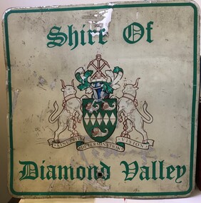
Sign - Boundary Sign, Shire of Diamond Valley, Shire of Diamond Valley boundary sign, 1990s
... Boundary Sign...Shire of Diamond Valley boundary sign......boundary signs...This example of a Boundary Sign was one of many located on the edge of the Shire e.g. at Wattle Glen Station; at Yan Yean Road north of Bannons Lane; 2 on Plenty Road near Larundel and Bundoora Primary School; one on the Para Road bridge; on Wattletree Road Eltham and on Kurrak Road Yarrambat. ...Shire of Diamond Valley boundary sign Sign Boundary Sign Shire of Diamond Valley ...The Shire of Diamond Valley was a Local Government Area located about 20 kilometres northeast of Melbourne. The shire covered an area of 74.38 square kilometres and existed from 1964 until 1994. This example of a Boundary Sign was one of many located on the edge of the Shire e.g. at Wattle Glen Station; at Yan Yean Road north of Bannons Lane; 2 on Plenty Road near Larundel and Bundoora Primary School; one on the Para Road bridge; on Wattletree Road Eltham and on Kurrak Road Yarrambat. According to a former Shire employee, the signs were often stolen as quickly as they were replaced. This sign was removed when the Shire of Diamond Valley was dissolved in 1994 and is signed by a Shire employee, giving it strong provenance.Painted metal sign, cream background with green text and Shire of Diamond Valley crest.Inscribed in felt tip pen on back of sign: SDV: from Nov 1964 to 1994. 30 years. Ron Middleton, By-laws Officer and Ranger, from 9/84 to Nov 94 [signed] R. Middletonshire of diamond valley, boundary signs -
 Whitehorse Historical Society Inc.
Article, Reins to city, 1995
... Whitehorse Council's Chief Executive Office, Dr Shirley Randall and Chief Commissioner, Geoff Oscar inspect the new boundary signs....Whitehorse Historical Society Inc. 2-10 Deep Creek Road Mitcham melbourne City of Whitehorse Logos Randell Shirley Oscar Geoff Whitehorse Council's Chief Executive Office, Dr Shirley Randall and Chief Commissioner, Geoff Oscar inspect the new boundary signs. Whitehorse Council's Chief Executive Office, Dr Shirley Randall and Chief Commissioner, Geoff Oscar inspect the new boundary signs. ...Whitehorse Council's Chief Executive Office, Dr Shirley Randall and Chief Commissioner, Geoff Oscar inspect the new boundary signs.Whitehorse Council's Chief Executive Office, Dr Shirley Randall and Chief Commissioner, Geoff Oscar inspect the new boundary signs.Whitehorse Council's Chief Executive Office, Dr Shirley Randall and Chief Commissioner, Geoff Oscar inspect the new boundary signs.city of whitehorse, logos, randell, shirley, oscar, geoff -
 Bendigo Historical Society Inc.
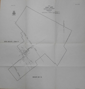
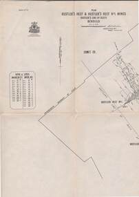
Map - COMET MINE - PLAN OF COMET MINE
... Map shows depths, Lightning Hill Anticline, Hustler's Anticline and approximate Lease Boundary. Signed by H. S. Whitelaw, Underground Survey Office Bendigo, September 1913. ...Map shows depths, Lightning Hill Anticline, Hustler's Anticline and approximate Lease Boundary. Signed by H. S. Whitelaw, Underground Survey Office Bendigo, September 1913. ...Plan of the Comet Mine on the Hustler's Line of Reefs Bulletin No 33, Plate No XXIII. Map shows depths, Lightning Hill Anticline, Hustler's Anticline and approximate Lease Boundary. Signed by H. S. Whitelaw, Underground Survey Office Bendigo, September 1913. United Hustler's & Redan Co and Hustler's Reef Co also named on map. Geological Survey of Victoriamining, hustler's line of reefs, comet line plan belletin no 33 plate no xxiii, lightning hill anticline, hustler's anticline, united hustler's & redan co, hustler's reef co, h s whitelaw -
 Bendigo Historical Society Inc.
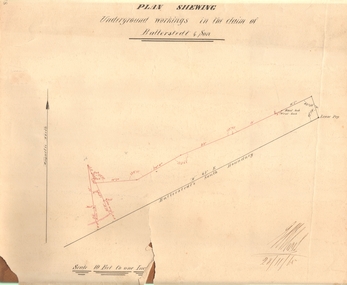
Document - MARKS COLLECTION: PLAN OF UNDERGROUND WORKING IN BALLERSTEDT & SON MINE, 28th November, 1965
... On bottom of drawing 'Ballerstedt's South Boundary'. Signed on bottom in black ink (indecipherable signature) and dated 28.11.65. ...On bottom of drawing 'Ballerstedt's South Boundary'. Signed on bottom in black ink (indecipherable signature) and dated 28.11.65. ...Buff coloured document, heavy parchment, printed in black. On top of plan 'plan showing underground workings in the claim of Ballerstedt & Son.' Plan shows underground workings in red, with distances and angles. On bottom of drawing 'Ballerstedt's South Boundary'. Signed on bottom in black ink (indecipherable signature) and dated 28.11.65. Document attached is related to the donor Phillipa Marks' family and contains the recollections of her great grandfather in regard to Bendigo's Jewish community and synagogues.bendigo, mining, ballerstedt & son mine -
 Ballarat Tramway Museum
Slide - 35mm slide/s - set of 6, Campbell Duncan, 19/09/1971 12:00:00 AM
... Tram has the destination of Sebastopol. .2 - No. 42, with destination of Lydiard St north, northbound in Lydiard St, with railway station buildings and VRI in the background. .3 - No. 35 on inbound, Lydiard St North. .4 - No. 35, on inbound service, leaving Skipton St loop with another bogie in the background. .5 - No. 39 on inbound service, Albert St Sebastopol with the Sebastopol boundary sign and Binks Ford in the background. ...Tram has the destination of Sebastopol. .2 - No. 42, with destination of Lydiard St north, northbound in Lydiard St, with railway station buildings and VRI in the background. .3 - No. 35 on inbound, Lydiard St North. .4 - No. 35, on inbound service, leaving Skipton St loop with another bogie in the background. .5 - No. 39 on inbound service, Albert St Sebastopol with the Sebastopol boundary sign and Binks Ford in the background. ...Yields information about the operations of the Ballarat Tramway system on the last day of SEC tramway operations in Ballarat.Set of 6 Kodak - Kodachrome slides - cardboard mounts - all taken on 19/9/1971, last day of operations prior to closure of the SEC operated tramway. .1 - Tram 40, waits at the level crossing gates - the gates are being opened. In the background is the station building and the signal gantry. Tram has the destination of Sebastopol. .2 - No. 42, with destination of Lydiard St north, northbound in Lydiard St, with railway station buildings and VRI in the background. .3 - No. 35 on inbound, Lydiard St North. .4 - No. 35, on inbound service, leaving Skipton St loop with another bogie in the background. .5 - No. 39 on inbound service, Albert St Sebastopol with the Sebastopol boundary sign and Binks Ford in the background. Tram has an everything under control in my all electric kitchen roof advert. .6 - No. 42, with destination of Sebastopol, Albert St Sebastopol.In ink on slide: .1 - Sun 19 Sept 71 - up Lydiard St Nth waits for gates to be opened after fast goods. .2 - Sun 19 Sept 1971, down Lydiard St Nth near VRI. .3 - Sun 19 Sept 1971, Up Lydiard St Nth .4 - Sun 19 Sept 1971, Up Sebastopol (supplementary service) has just crossed down in Skipton St near Drummond St. .5 - Sun 19 Sept 1971, Up Sebas at Ballarat / Sebastopol boundary. .6 - Sun 19 Sept 1971, c5.30pm down Sebas in Sebas shire.tramways, trams, lydiard st nth, railway station, level crossings, skipton st, albert st, sebastopol, closure, last day, tram 40, tram 42, tram 35, tram 39 -
 Kiewa Valley Historical Society
Papers - Havilah Cemetery, Havilah Cemetery Formerly Running Creek Cemetery
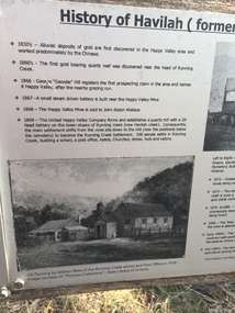
... boundary (May 2024). One paper lists 29 names in the Burial Register 1861-1948. The last two sheets record the history as a timeline from the 1850s to the 1900s. Havilah was a gold mining settlement from the 1850s located 20km west of the Kiewa Valley and in the Ovens catchment near Myrtleford. Havilah Running Creek Cemetery Five black and white A4 pages stapled together. Copies of the sign ...In 1889, 24 residents of the Running Creek and surrounding district submitted a petition to the Minister of Lands, Melbourne requesting land for a cemetery. Their request was granted. The Cemetery was decommissioned in the early 1950s and the last trustee for the cemetery died in 1986. There is a wooden fence around the boundary (May 2024). One paper lists 29 names in the Burial Register 1861-1948. The last two sheets record the history as a timeline from the 1850s to the 1900s. Havilah was a gold mining settlement from the 1850s located 20km west of the Kiewa Valley and in the Ovens catchment near Myrtleford.Five black and white A4 pages stapled together. Copies of the sign erected at the gate of 'Havilah cemetery formerly Running Creek Cemetery'. Also the 'History of Havilah formerly Running Creek'havilah, running creek, cemetery -
 Wycheproof & District Historical Society Inc.
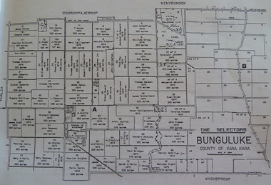
Bunguluke Map, Bunguluke District In 1923, 27.2.1923
... sign of community life with houses few and far between and acreages have gone into larger holdings. The map references land blocks and owners for that era. This important map shows the local land ownership and local features that existed in 1923. Map Bunguluke Jeruk Wycheproof Cooroopajerrup This is a photocopied black and white map of Bunguluke in the County of Kara Kara, Number L5149. Marked - Photo Lithographed by W.J. Butson 27.2.1923. The details include numbers of allotments, property owners, roads, rivers. The boundaries ...By 1881 Bunguluke was a small settlement as recorded, December 5, in the Charlton "Mercury". It reports that in that year Draper's Store, Hotel and Post Office and residence at Bunguluke North was totally destroyed by fire. For years now there has been little sign of community life with houses few and far between and acreages have gone into larger holdings. The map references land blocks and owners for that era.This important map shows the local land ownership and local features that existed in 1923. This is a photocopied black and white map of Bunguluke in the County of Kara Kara, Number L5149. Marked - Photo Lithographed by W.J. Butson 27.2.1923. The details include numbers of allotments, property owners, roads, rivers. The boundaries marked are the Parish of Jeruk, Parish of Wycheproof, Parish of Cooroopajerrup. Wycheproof township location is shown with the Scale of Chains. Bunguluke maps for other years are also in the collection.map, bunguluke, jeruk, wycheproof, cooroopajerrup -
Glen Eira Historical Society
Document - History of the City of Caulfield
... boundaries and wards showing locations of railway stations and parks. Document covers the structure of local government and its functions then goes on to focus on City of Caulfield with subjects similar to those covered in item 3. Document signed...boundaries and wards showing locations of railway stations and parks. Document covers the structure of local government and its functions then goes on to focus on City of Caulfield with subjects similar to those covered in item 3. Document signed ...This file contains 4 items: 1/Typewritten document titled ‘The City of Caulfield’. Author and date unknown. 1 page (back and front), 2 copies. Document covers topics such as origins of the name ‘Caulfield’, early settlement and the Caulfield Cup. 2/Typewritten document titled ‘History of Caulfield Council’. Author and date unknown. 6 pages, 3 copies. Document covers subjects such as early settlement, Aboriginal influence, Caulfield Road Board, Shire of Caulfield, Borough and town boundaries, coat of arms, and Freedom of Entry to the City. 3/Typewritten document (undated + author unknown) titled ‘The Structure of Local Government in Victoria with a history of the City of Caulfield’. 13 pages. Covers the following subjects: Powers, Planning, Public Works, Trading Undertakings, Health Services, Municipalities, Wards Electors or Ratepayers, Voters Roll, Councillors, Officers, Finance, Nature of Soil and Vegetation, Parks and Gardens and Reserves, Coat of Arms, Boundaries, How Did Caulfield get its Name, Aboriginal Influence, Caulfield Road Board, Shire of Caulfield, Borough and Town and the City of Caulfield. Also covered is early settlement. Note at the end of the document mentions that the historical content contained in the last section was based upon a thesis for the Department of Town and Regional Planning, University of Melbourne, 1968 by L. Alwis, P. Rowe, N. Wootten. Melbourne, ‘City of Caulfield: An Illustrated City Report’. 4/Typewritten document (undated) titled ‘The Structure of Local Government in Victoria with notes on the history of the City of Caulfield’. 8 pages, 2 copies. This document also includes a map/diagram of the city with boundaries and wards showing locations of railway stations and parks. Document covers the structure of local government and its functions then goes on to focus on City of Caulfield with subjects similar to those covered in item 3. Document signed off by Deputy Town Clerk.city of caulfield, caulfield john, caulfield baron, caulfield racecourse, elsternwick, ripponlea, st. mary’s church, caulfield council, kooyong road, neerim road, bambra road, greenmeadows house, caulfield park, paddy’s swamp, dandenong road, caulfield grammar school, chisholm institute of technology, murrumbeena, glen eira road, alma road, orrong road, balaclava road, inkerman road, ‘grosmont’, caulfield school room, caulfield road board, caulfield road district, crimean war, victorian amateur turf club, caulfield cup, glenhuntly road, north road, glenhuntly station, ormond station, outer circle railway, local government, gardenvale, carnegie, rosstown, poath road, nepean highway, hotham street, ormond park, princes park, ross william murray, caulfield institute of technology, ‘ross’ folly’, hawthorn road, glenhuntly, ormond, morris t. w., lloyd charles du plan, meals on wheels, shire of caulfield, caulfield railway station, caulfield rsl, bouran road, murrum murrumbeen, kooyong road, great dandenong road, neerim road, trams, prahran and malvern tramways trust, fisher andrew, mackinnon reserve, dover street, ‘glen eira’, blair max cr., insignia, third ordnance services unit, schools, street lighting, lampriere, mr. bevan, the caulfield leader, davies j. henry, curraweena road, st. georges road, o’neill college, hope george, market gardens, koornang reserve, packer reserve, murrumbeena reserve, hopetoun gardens, greenmeadows gardens, mirambeena, caulfield technical college, hart john, langdon h. j., ‘rosecraddock’, judge webb, ‘crotonhurst’, service james, ‘kilwinning’, ricketson henry, grimwade frederick sheppard, airdrie, jenner, st. aubin’s, caulfield john p. t., harlston, lempriere, lord reserve, ‘cantala’ -
 Glen Eira Historical Society
Letter - Eastleigh Community Church, East Boundary Road, 216
... sign on the front wall. Pearson Bob Deakin Street McKinnon Eastleigh Community Church Bentleigh East Eastleigh Gospel Chapel Walsh Brian Coates Lindsay McKinnon Gospel Hall East Boundary Road Bent Street Letter Eastleigh Community Church, East Boundary Road, 216 ...Two items about this Church: 1/ Printed Email from Brian Walsh, giving brief details of his time at Eastleigh Community Church and McKinnon Gospel Hall dated 21/04/2010 and Reply dated 03/06/2012. 2/ 3 digital photos taken on 20/02/2010 by Claire Barton for GEHS project: 2 different views of the street frontage for the Church and 1 view of the sign on the front wall.pearson bob, deakin street, mckinnon, eastleigh community church, bentleigh east, eastleigh gospel chapel, walsh brian, coates lindsay, mckinnon gospel hall, east boundary road, bent street -
 Eltham District Historical Society Inc
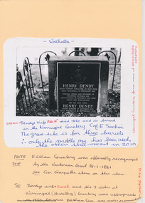
Document - Folder, Dendy, 2012
... No sign of Dendy's house or mill remain on the Community Centre site but some of the old trees running along the former boundary through the centre of the site could well have been planted in Dendy' s time. ...No sign of Dendy's house or mill remain on the Community Centre site but some of the old trees running along the former boundary through the centre of the site could well have been planted in Dendy' s time. ...Henry Dendy (1800-1881) was an early settler of Eltham where he operated a flour mill. He donated land for the construction of St Margaret's Anglican Church. EDHS Newsletter No. 168 May 2006 Dendy is best known as the founder of Brighton, but it is not so well known that years later he lived at Eltham for far longer than he lived at Brighton. In 1840 while still in England he bought eight square miles of unspecified land in the Port Phillip District. This entitled him to bring a number of other persons to the colony and in 1841 he arrived at Williamstown in the "York" with his family and 139 others. He took up his land entitlement at what is now Brighton and most of the emigrants settled there. He encountered financial problems and lost his interest in the estate in 1844. He left Brighton in 1847. He successively but not always successfully became a brewer at Geelong, a sheep farmer at Christmas Hills and Upper Moira, a flour miller at Eltham; a sheep farmer again at Werribee and finally a copper miner at Walhalla. Dendy came to Eltham in 1856 after having spent a year in England. The total of the two parcels of land that he bought was about 5 acres (2 hectares) and it included the steam flour mill. . He became prominent in local affairs, serving for a time on the Eltham District Road Board, including one year as President. Dendy' s wife Sarah died at Eltham in 1860 and also in that year he was appointed chairman of a committee to establish a Church of England in Eltham. He donated one of his Pitt Street lots for this purpose and St Margaret's was opened in 1861. In 1867 Dendy sold his mill to W. F. Ford and moved to Werribee and then Walhalla where he remained until his death. He is buried in the Walhalla cemetery. No sign of Dendy's house or mill remain on the Community Centre site but some of the old trees running along the former boundary through the centre of the site could well have been planted in Dendy' s time. Much of this information was obtained from the book ''Henry Dendy and his Emigrants" by L.A. Schumer (Sallas Books 1975). The Society has an extensive file of Dendy information, much of it provided by the late Leslie Schumer. Manilla folder of information. Includes Folder 88 from Harry Gilham Collection which includes EDHS tour notes of St Margaret's Anglican Church, Eltham, 2012, copy of newspaper article, Diamond Valley News, December 15, 1981, copy of newspaper article, The Advertiser, September 2, 1932, photocopy of photograph of graves at Walhalla Cemetery and Warringal Cemetery, photocopies, 6 pages from an unsourced book. henry dendy, st margaret's anglican church, catholic section, eltham cemetery, harry gilham collection, sarah dendy, walhalla cemetery -
 Eltham District Historical Society Inc
Photograph, Liz Pidgeon, Heritage Excursion; Maroondah Aqueduct, 3 September 2016, 3 September 2016
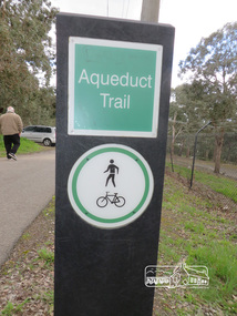
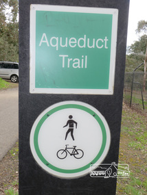
... boundary of Eltham. (Melway ref.12 B10). maroondah aqueduct eltham north activities eltham district historical society heritage excursion acqueduct trail sign Born Digital Heritage Excursion; Maroondah Aqueduct, 3 September 2016 Photograph Photograph Liz Pidgeon ...Newsletter No., 229, August 2016 Heritage Excursion - Maroondah Aqueduct Walk - Saturday 3rd September The Maroondah Aqueduct was once a major link in Melbourne’s water supply system. It was built between 1886 and 1891 to transfer water from the Watts River near Healesville to the Preston Reservoir. It was 66 km in length, made up of 41 km of open channel, 10 km of tunnel through hills and 15 km of pipeline across stream valleys known as inverted siphons. The section of the aqueduct through the Eltham area has been abandoned since the 1980s but the open channel has largely been retained. A recreational path follows the aqueduct reserve. For our excursion on 3rd September we intend to walk along the section of the aqueduct adjacent to Allendale Road. This is a section not visited on previous excursions and includes the transition from open channel to the inverted siphon across the Diamond Creek valley. Apart from the aqueduct itself the main feature of the walk is the extensive views across Eltham North and Diamond Creek. Along the way we will talk about the history of the aqueduct and the area. This easy walk is about 3 km return and will take 2 to 2.5 hours. It will start at 2pm at the junction of Allendale Road with Godber Road and Zig Zag Road North, officially Diamond Creek, but on the northern boundary of Eltham. (Melway ref.12 B10). Born Digitalmaroondah aqueduct, eltham north, activities, eltham district historical society, heritage excursion, acqueduct trail, sign -
 Eltham District Historical Society Inc
Photograph, Liz Pidgeon, Heritage Excursion; Maroondah Aqueduct, 3 September 2016, 3 September 2016
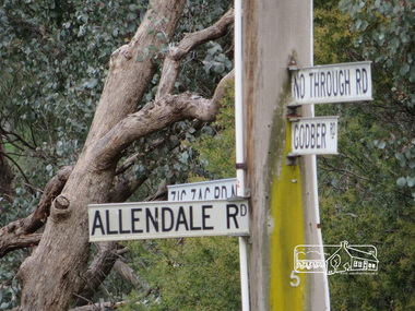
... boundary of Eltham. (Melway ref.12 B10). maroondah aqueduct eltham north activities eltham district historical society heritage excursion street signs acqueduct trail Allendale Rd Godber Rd Zig Zag Road intersection Born Digital Heritage Excursion; Maroondah Aqueduct, 3 September 2016 Photograph Photograph Liz Pidgeon ...Intersection with local Street signs Newsletter No., 229, August 2016 Heritage Excursion - Maroondah Aqueduct Walk - Saturday 3rd September The Maroondah Aqueduct was once a major link in Melbourne’s water supply system. It was built between 1886 and 1891 to transfer water from the Watts River near Healesville to the Preston Reservoir. It was 66 km in length, made up of 41 km of open channel, 10 km of tunnel through hills and 15 km of pipeline across stream valleys known as inverted siphons. The section of the aqueduct through the Eltham area has been abandoned since the 1980s but the open channel has largely been retained. A recreational path follows the aqueduct reserve. For our excursion on 3rd September we intend to walk along the section of the aqueduct adjacent to Allendale Road. This is a section not visited on previous excursions and includes the transition from open channel to the inverted siphon across the Diamond Creek valley. Apart from the aqueduct itself the main feature of the walk is the extensive views across Eltham North and Diamond Creek. Along the way we will talk about the history of the aqueduct and the area. This easy walk is about 3 km return and will take 2 to 2.5 hours. It will start at 2pm at the junction of Allendale Road with Godber Road and Zig Zag Road North, officially Diamond Creek, but on the northern boundary of Eltham. (Melway ref.12 B10). Born Digitalmaroondah aqueduct, eltham north, activities, eltham district historical society, heritage excursion, street signs, acqueduct trail, allendale rd, godber rd, zig zag road, intersection -
 Eltham District Historical Society Inc
Photograph, Liz Pidgeon, Heritage Excursion; Maroondah Aqueduct, 3 September 2016, 3 September 2016
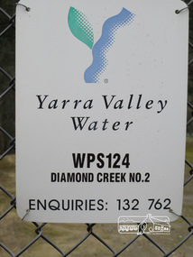
... boundary of Eltham. (Melway ref.12 B10). maroondah aqueduct eltham north activities eltham district historical society heritage excursion diamond creek yarra valley water sign Born Digital Heritage Excursion; Maroondah Aqueduct, 3 September 2016 Photograph Photograph Liz Pidgeon ...Sign for Yarra Valley Water at Diamond Creek property Newsletter No., 229, August 2016 Heritage Excursion - Maroondah Aqueduct Walk - Saturday 3rd September The Maroondah Aqueduct was once a major link in Melbourne’s water supply system. It was built between 1886 and 1891 to transfer water from the Watts River near Healesville to the Preston Reservoir. It was 66 km in length, made up of 41 km of open channel, 10 km of tunnel through hills and 15 km of pipeline across stream valleys known as inverted siphons. The section of the aqueduct through the Eltham area has been abandoned since the 1980s but the open channel has largely been retained. A recreational path follows the aqueduct reserve. For our excursion on 3rd September we intend to walk along the section of the aqueduct adjacent to Allendale Road. This is a section not visited on previous excursions and includes the transition from open channel to the inverted siphon across the Diamond Creek valley. Apart from the aqueduct itself the main feature of the walk is the extensive views across Eltham North and Diamond Creek. Along the way we will talk about the history of the aqueduct and the area. This easy walk is about 3 km return and will take 2 to 2.5 hours. It will start at 2pm at the junction of Allendale Road with Godber Road and Zig Zag Road North, officially Diamond Creek, but on the northern boundary of Eltham. (Melway ref.12 B10). Born Digitalmaroondah aqueduct, eltham north, activities, eltham district historical society, heritage excursion, diamond creek, yarra valley water, sign -
Port Melbourne Historical & Preservation Society
Plan - Metalling and channelling Evans Street from Ingles Street to Boundary Street, 14 Mar 1893
... signed by J.J. Bartlett. (Mayor). Specifications (94.1) and Plan (94.2) for metalling and channelling Evans Street from Ingles Street to Boundary Street . ...Specifications (94.1) and Plan (94.2) for metalling and channelling Evans Street from Ingles Street to Boundary Street . Loan Works 1893. Plan number 8.Both signed by J.J. Bartlett. (Mayor).engineering - roads streets lanes and footpaths, town planning, town clerks, mayors, arthur victor heath, james john bartlett -
Port Melbourne Historical & Preservation Society
Document - Specification, Metalling and chanelling, Danks Street from Esplanade East to Boundary Street South, Engineering Department, Town of Port Melbourne, 14 Mar 1893
... Port Melbourne Historical & Preservation Society Port Melbourne Town Hall 333 Bay Street Port Melbourne melbourne Engineering - Roads Streets Lanes and Footpaths Town Planning Town Clerks Mayors Arthur Victor HEATH James John BARTLETT Signed by JJ Bartlett (Mayor) 14.3.1893 Specification for metalling and channelling Danks Street from Esplanade East to Boundary Street South (Pickles Street) Loan Works 1893 plan 19; relates to plan 98.2 Document Specification, Metalling and chanelling, Danks Street from Esplanade East to Boundary Street South Engineering Department, Town of Port Melbourne ...Specification for metalling and channelling Danks Street from Esplanade East to Boundary Street South (Pickles Street) Loan Works 1893 plan 19; relates to plan 98.2Signed by JJ Bartlett (Mayor) 14.3.1893engineering - roads streets lanes and footpaths, town planning, town clerks, mayors, arthur victor heath, james john bartlett -
Port Melbourne Historical & Preservation Society
Plan - Metalling and channelling Danks Street from Esplanade East to Boundary Street South, Engineering Department, Town of Port Melbourne, 14 Mar 1893
... Port Melbourne Historical & Preservation Society Port Melbourne Town Hall 333 Bay Street Port Melbourne melbourne Engineering - Roads Streets Lanes and Footpaths Town Planning Town Clerks Mayors Arthur Victor HEATH James John BARTLETT Signed by JJ Bartlett (Mayor) 14.3.1893 Plan for metalling and channelling Danks Street from Esplanade East to Boundary Street South (Pickles Street) Loan Works 1893 plan 19; relates to specification 98.1 Plan Metalling and channelling Danks Street from Esplanade East to Boundary Street South Engineering Department, Town of Port Melbourne ...Plan for metalling and channelling Danks Street from Esplanade East to Boundary Street South (Pickles Street) Loan Works 1893 plan 19; relates to specification 98.1Signed by JJ Bartlett (Mayor) 14.3.1893engineering - roads streets lanes and footpaths, town planning, town clerks, mayors, arthur victor heath, james john bartlett -
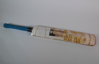 Bendigo Historical Society Inc.
Leisure object - Rohan Moresi signed Cricket Bat
... boundary. I remember Clive Lloyd, who was sitting in the stands when I approached him, expressing some good natured scepticism that the signatures would remain permanently on the bat as he was signing it, due to the tyupe of marker pen used. ...boundary. I remember Clive Lloyd, who was sitting in the stands when I approached him, expressing some good natured scepticism that the signatures would remain permanently on the bat as he was signing it, due to the tyupe of marker pen used. ...Information provided to the Bendigo Historical Society by Rohan Moresi: Rohan 'grew up on a farm near Buckrabanyule. The bat belonged to Rohan and his brothers, Grant and Alistair. At the age of twelve in early December of 1977, my father took my brothers and myself to the Queen Elizabeth Oval in Bendigo to watch a match of the newly created World Series Cricket being played. West Indies versus World XI. OI took the one cricket bat we owned and a market pen, along with me. During the course of the match I gathered all the signatures I could from players as they left the field after batting, as they sat in the stands waiting for their turn to bat, and when they were fielding close to the boundary. I remember Clive Lloyd, who was sitting in the stands when I approached him, expressing some good natured scepticism that the signatures would remain permanently on the bat as he was signing it, due to the tyupe of marker pen used. I also recall Tony Greig not stopping to sign it as he left the field after batting. I'm sure he had other more pressing issues on his mind at the time. When we returned home my father painted a type of a lacquer over each of the signatures in an attempt to ensure some sort of permanency. As it was the only cricket bat my brothers and I had, we continued to use it in our backyard games. Which goes a long way in explaining its current state. My brothers and I all left the farm in the early 1980's and I took the cricket bat with me. Since then it has remained in my possession up until now. I'm very happy to see it returned to the place of its origin, and for it to be kept in perpetuity at the Bendigo Hisgtorical Society, as it is part of the twentieth century history of Bendigo. I hope it brings some small pleasure to all who are interested in such things'. Rohan Moresi Cricket bat, blue material on handle grip of bat. Bat has signatures on the blade section. The bat was taken by Rohan Morosi, then 12, at the Queen Elizabeth Oval in December 1977, where he attended a game of the newly created World Series Cricket competition between West Indies versus World XI. Rohan gathered many signatures from players as they left after batting. The signature of Clive Lloyd, Ajif Labal, Mushtag Mohammed, Dennis Amiss, Eddie Barlow, Andy Roberts, Bob Woolmer, Barry Richards, Imran Khan and Joel Garner were on the bat.recreations, sports, cricket, queen elizabeth oval, rohan moresi, 1977 -
 Bendigo Historical Society Inc.
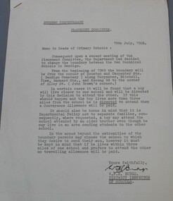
Document - Technical school in Bendigo
... Attached to the letter two drawing showing in the first the area covered by the white Hills technical school and the Kangaroo Flat technical school and in the second the Bendigo, Golden Square and Eaglehawk High School boundaries. The letter is dated 19th July 1968 and signed by W.F.R Budge (District Inspector of Schools) Aileen and John Ellison Collection....Attached to the letter two drawing showing in the first the area covered by the white Hills technical school and the Kangaroo Flat technical school and in the second the Bendigo, Golden Square and Eaglehawk High School boundaries. The letter is dated 19th July 1968 and signed by W.F.R Budge (District Inspector of Schools) Aileen and John Ellison Collection. ...BHS CollectionTypewritten letter from the Bendigo Inspectorate placement committee to the heads of Primary schools advising them of the change to the boundary between the two technical school. Attached to the letter two drawing showing in the first the area covered by the white Hills technical school and the Kangaroo Flat technical school and in the second the Bendigo, Golden Square and Eaglehawk High School boundaries. The letter is dated 19th July 1968 and signed by W.F.R Budge (District Inspector of Schools) Aileen and John Ellison Collection.technical school, white hills technical, kangaroo flat technical -
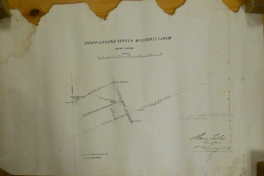 Bendigo Historical Society Inc.
Plan - MARKS COLLECTION: UNDERGROUND SURVEY MR. DENNIS CLAIM NEW CHUM
... Dennis, New Chum' Signed: Thomas Forbes, Surveyor, 11th. January 1867. shows surface boundary of Dennis and Bonati. ...Dennis, New Chum' Signed: Thomas Forbes, Surveyor, 11th. January 1867. shows surface boundary of Dennis and Bonati. ...Plan on heavy parchment paper. On top of plan 'underground survey Mr. Dennis, New Chum' Signed: Thomas Forbes, Surveyor, 11th. January 1867. shows surface boundary of Dennis and Bonati. Written in blue pencil 'From nail in sapling 33f. 51/2 to boundary. Online to drill hole' Shaft marked on LH boundary.'bendigo, mining, mr. dennis claim, new chum -
 Bendigo Historical Society Inc.
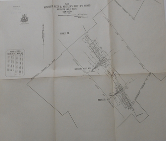
Map - STRUGNELL COLLECTION: HUSTLER'S LINE OF REEF, September 1913
... X1V (14) Comet Co. .Bulletin No 33 Signed H.A.Whitelaw. Drawing shows reef boundary lines .There is an explanatory box showing depth in feet and inches of the mines ....X1V (14) Comet Co. .Bulletin No 33 Signed H.A.Whitelaw. Drawing shows reef boundary lines .There is an explanatory box showing depth in feet and inches of the mines . ...Map, Hustler's Line of Reefs, Hustler's Reef & Hustler's Reef No.1 Mines Bendigo.Plate No. X1V (14) Comet Co. .Bulletin No 33 Signed H.A.Whitelaw. Drawing shows reef boundary lines .There is an explanatory box showing depth in feet and inches of the mines .Underground Survey Office, Bendigo.map, bendigo, hustler's reef & hustler's reef 1 -
 Bendigo Historical Society Inc.
Document - COHN BROTHERS COLLECTION: SHARE SCRIP
... Signed in the presence of G N Craig. Two sisters were Gentlewomen of Boundary Rd Sandhurst. ...Signed in the presence of G N Craig. Two sisters were Gentlewomen of Boundary Rd Sandhurst. ...a, Cohn Bros Victoria Brewery Co Limited share scrip No 426 certifying that G V Craig of Bendigo was the holder of ten shares with progressive numbers from 29986 - 29995. Dated at Bendigo on 18th day of August 1903. Share Capital of £55,000 in 55,000 shares or 20 shillings each. E A Haskey secretary witnessed the two directors, Jacob Cohn, Magnus Cohn signing share document. .b, Transfer document No 289 of shares numbering 29886- 29995 held by George Napier Craig of Bendigo to Sarah Anne Craig and Emily Mary Craig on 17th December 1906. Signed in the presence of G N Craig. Two sisters were Gentlewomen of Boundary Rd Sandhurst. One penny stamp duty affixed.bendigo, industry, cohns brewery, cohns bros victoria brewery. g n craig. cohns share transfer -
 Bendigo Historical Society Inc.
Map - UNITED HUSTLER'S & REDAN & K. K. MINES - PLAN OF UNITED HUSTLER'S & REDAN & K. K. MINES
... Boundary of Lease. Also mentions Comet Co. Geological Survey of Victoria emblem and signed by H S Whitelaw, Underground Survey Office Bendigo September 1913....Boundary of Lease. Also mentions Comet Co. Geological Survey of Victoria emblem and signed by H S Whitelaw, Underground Survey Office Bendigo September 1913. ...Plan of the United Hustler's & Redan & K. K. Mines on the Hustler's Line of Reefs Bulletin No 33 Plate No XXVII. Plan shows depth of levels, Long Gully, Hustler's Line of Reefs, Lightning Hill Line of Reefs and approximate Boundary of Lease. Also mentions Comet Co. Geological Survey of Victoria emblem and signed by H S Whitelaw, Underground Survey Office Bendigo September 1913.mining, parish map, united hustler's & redan & k. k. mines, long gully, hustler's line of reefs, lightning hill line of reefs, comet co, h s whitelaw, geological survey of victoria, underground survey office -
 Bendigo Historical Society Inc.
Map - COMET MINE - LONGITUDINAL SECTION COMET MINE
... signed by H. S. Whitelaw, Underground Survey Office Bendigo, September 1913. Map shows datum lines, depths of levels, approximate boundaries and references to other plans. ...signed by H. S. Whitelaw, Underground Survey Office Bendigo, September 1913. Map shows datum lines, depths of levels, approximate boundaries and references to other plans. ...Longitudinal section of the Comet Mine on the Hustler's Line of Reef Bulletin No 33, Plate No XXVI signed by H. S. Whitelaw, Underground Survey Office Bendigo, September 1913. Map shows datum lines, depths of levels, approximate boundaries and references to other plans. Note - Plates 4, 8, 13, 20, 26 and 31 form a Longitudinal Section from Fortuna Hustler's to Hustler's Consols Mine. Geological Survey of Victoriamining, parish map, hustler's line of reef, longitudinal section of comet mine bulletin no 33 plate no xxvi, h s whitelaw -
 Bendigo Historical Society Inc.
Map - COMET MINE - PLAN OF COMET MINE
... Plan of the Comet Mine on the Hustler's Line of Reefs Bulletin No 33, Plate No XXIV signed by H S Whitelaw, Underground Survey Office Bendigo, September 1913. Upper and Lower Levels and approximate boundaries shown. ...History House 11 Mackenzie Street Bendigo goldfields MINING Parish Map Hustler's Line of Reefs Comet Mine Plan Bulletin No 33 Plate No XXIV Geological Survey of Victoria Plan of the Comet Mine on the Hustler's Line of Reefs Bulletin No 33, Plate No XXIV signed by H S Whitelaw, Underground Survey Office Bendigo, September 1913. Upper and Lower Levels and approximate boundaries shown. ...Plan of the Comet Mine on the Hustler's Line of Reefs Bulletin No 33, Plate No XXIV signed by H S Whitelaw, Underground Survey Office Bendigo, September 1913. Upper and Lower Levels and approximate boundaries shown. Depths shown.Geological Survey of Victoriamining, parish map, hustler's line of reefs, comet mine plan bulletin no 33 plate no xxiv -
 Bendigo Historical Society Inc.
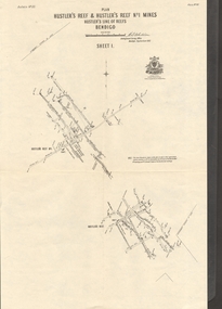
Map - HUSTLER'S REEF & HUSTLER'S REEF NO 1 MINES - PLAN OF THE HUSTLER'S REEF & HUSTLER'S REEF NO 1 MINES
... Map shows different levels in relation to the two shafts, the lines of the Hustler's Line of Reefs and the Lightning Hill Line of Reefs, the approximate Boundary of Lease and the Comet Co., the adjoining lease. Table on the left shows the levels and their depths of the two mines. Signed...Map shows different levels in relation to the two shafts, the lines of the Hustler's Line of Reefs and the Lightning Hill Line of Reefs, the approximate Boundary of Lease and the Comet Co., the adjoining lease. Table on the left shows the levels and their depths of the two mines. Signed ...Plan of the Hustler's Reef & Hustler's Reef No 1 Mines on the Hustler's Line of Reefs, Bendigo Bulletin No 33, Plate No XIV. No 8 connecting No 10 (Hustler's Reef), No 11 connecting No 13 (Hustler's Reef), No 13 (Hustler's Reef No 1) connecting No 15 (Hustler's Reef) and No 10 Hustler's Reef No 1 rise to Comet Mine. Map shows different levels in relation to the two shafts, the lines of the Hustler's Line of Reefs and the Lightning Hill Line of Reefs, the approximate Boundary of Lease and the Comet Co., the adjoining lease. Table on the left shows the levels and their depths of the two mines. Signed by H A Whitelaw, Underground Survey Office, Bendigo, September 1913. Geological Survey of Victoria emblem. mining, parish map, hustler's reef & hustler's reef no 1 mines, hustler's line of reefs lightning hill line of reefs, comet co., h a whitelaw, underground survey office bendigo, geological survey of victoria -
 Bendigo Historical Society Inc.
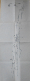
Map - HUSTLER'S REEF & HUSTLER'S REEF NO 1 MINES - PLAN OF THE HUSTLER'S REEF & HUSTLER'S REEF NO 1 MINES
... Geological Survey of Victoria emblem and signed by H A Whitelaw, Underground Survey Office Bendigo, September 1913. Note - The Lease Boundaries shown on this plan are only in their approximate relative positions to Nos 13, Intermediate and 14 Levels of the Hustler's Reef No 1 workings, and Nos 15, 16 and 17 Levels of the Hustler's Reef workings....Geological Survey of Victoria emblem and signed by H A Whitelaw, Underground Survey Office Bendigo, September 1913. Note - The Lease Boundaries shown on this plan are only in their approximate relative positions to Nos 13, Intermediate and 14 Levels of the Hustler's Reef No 1 workings, and Nos 15, 16 and 17 Levels of the Hustler's Reef workings. ...Plan of the Hustler's Reef & Hustler's Reef No 1 Mines on the Hustler's Line of Reefs Bulletin No 33, Plate No XV. Plan shows the two mines with depth of levels, geological features and levels in relation to the shaft. Geological Survey of Victoria emblem and signed by H A Whitelaw, Underground Survey Office Bendigo, September 1913. Note - The Lease Boundaries shown on this plan are only in their approximate relative positions to Nos 13, Intermediate and 14 Levels of the Hustler's Reef No 1 workings, and Nos 15, 16 and 17 Levels of the Hustler's Reef workings.mining, parish map, hustler's reef & hustler's reef no 1 mines, geological survey of victoria, underground survey office bendigo, h a whitelaw, hustler's line of reefs -
 Bendigo Historical Society Inc.
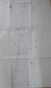
Map - HUSTLER'S ROYAL RESERVE NO 2 MINE - PLAN OF THE HUSTLER'S ROYAL RESERVE NO 2 MINE
... Boundary of Leases No 8898 and 8897 shown. Various levels shown and some geographical features. Geological Survey of Victoria emblem. H . Harman, Director, W. Dickson, Secretary for Mines and The Hon. J. Drysdale Brown, Minister of Mines and signed...Boundary of Leases No 8898 and 8897 shown. Various levels shown and some geographical features. Geological Survey of Victoria emblem. H . Harman, Director, W. Dickson, Secretary for Mines and The Hon. J. Drysdale Brown, Minister of Mines and signed ...Plan of the Hustler's Royal Reserve No 2 Mine on the Hustler's Line of Reefs Bulletin No 33, Plate No VI. Boundary of Leases No 8898 and 8897 shown. Various levels shown and some geographical features. Geological Survey of Victoria emblem. H . Harman, Director, W. Dickson, Secretary for Mines and The Hon. J. Drysdale Brown, Minister of Mines and signed by H Whitdon, Underground Survey Office, Bendigo, September 1913. mining, parish map, hustler's royal reserve no 2 mine, hustler's line of reefs, geological survey of victoria, h herman, w dickson, the hon j drysdale brown mlc -
 Bendigo Historical Society Inc.
Map - HUSTLER'S ROYAL RESERVE NO 2 MINE - PLAN OF THE HUSTLER'S ROYAL RESERVE NO 2 MINE
... boundary of Lease No 8892 and 8897. There are also street names and the locations of jail, lagoons, Post Office, Rosalind Park and the State School, High School and Continuation School. Geological Survey of Victoria emblem. H. Herman Director, W. Dickson, Secretary of Mines and The Hon. J. Drysdale Brown MLC, Minister of Mines. Signed...boundary of Lease No 8892 and 8897. There are also street names and the locations of jail, lagoons, Post Office, Rosalind Park and the State School, High School and Continuation School. Geological Survey of Victoria emblem. H. Herman Director, W. Dickson, Secretary of Mines and The Hon. J. Drysdale Brown MLC, Minister of Mines. Signed ...Plan of the Hustler's Royal Reserve No 2 Mine Bulletin No 33, Plate No V. Plan shows the Hustler's Royal Reserve No 2 (Main Shaft), Hustler's Royal Reserve No 2 (Park Shaft.), the Royal Hustler's, the Imperial Hustler's and the Extended Hustler's Freehold on the Hustler's Line of Reefs. Also mentioned is the Lightning Hill Line of Reefs. Map shows some of the levels, approximate boundary of lease and the boundary of Lease No 8892 and 8897. There are also street names and the locations of jail, lagoons, Post Office, Rosalind Park and the State School, High School and Continuation School. Geological Survey of Victoria emblem. H. Herman Director, W. Dickson, Secretary of Mines and The Hon. J. Drysdale Brown MLC, Minister of Mines. Signed by zh Whitdan, Underground Survey Office, Bendigo, September 1913.mining, parish map, hustler's royal reserve no 2 mine, royal hustler's, imperial hustler's, extended hustler's freehold, geological survey of victoria, h herman, w dickson, the hon j drysdale brown, h whitdan, hustler's line of reefs, lightning hill line of reefs