Showing 111 items matching building permits
-
 Tatura Irrigation & Wartime Camps Museum
Sketch, 1943
Josef Thum was a Austrian artist in Camp 13, as a POW. Ken Hill was a member of AAAS - Mobile Cinema Unit 36 around 1946-47 and based at Murchison. After hostilities ceased, Thum was permitted to assist Ken Hill in the presentation of "pictures" as was the common term of the period, each time there was a screening at MurchisonBlack and white pencil sketch of a bridge, Church Spire and building in Melbourne. Dated 17.8.43. A piece of tissue paper is attached to cover the sketch."melbourne", sketch, thum j, hill k, aaas, camp 13, tatura, illustrations, pencil -
Koorie Heritage Trust
Book, Bannister, S, British colonization and coloured tribes, 1838
the whole aborigines subject must soon be taken up by the best statesmen in this country. National efforts alone will turn mischievous squatters into useful settlers, and lead aright the tens of thousands at this moment bursting through every frontier we occupy in Canada, in South Africa, and in all the Australias. without national effforts to correct present oppression, buccaneering in every remote sea must spring out of the indulgence now permitted with impunity to the violent passions of uncontrolled men; and witout national effforts now put forth, to follow up and crown those of the admirable missionaries, the possession of unwatched power will corrupt even them; and the whole work, now calling for your aid, must be done hereafter with lessened means of success and infinitely increased obstacles.p.323; appendices; 19 cm.the whole aborigines subject must soon be taken up by the best statesmen in this country. National efforts alone will turn mischievous squatters into useful settlers, and lead aright the tens of thousands at this moment bursting through every frontier we occupy in Canada, in South Africa, and in all the Australias. without national effforts to correct present oppression, buccaneering in every remote sea must spring out of the indulgence now permitted with impunity to the violent passions of uncontrolled men; and witout national effforts now put forth, to follow up and crown those of the admirable missionaries, the possession of unwatched power will corrupt even them; and the whole work, now calling for your aid, must be done hereafter with lessened means of success and infinitely increased obstacles.colonization. | indigenous peoples. | indigenous peoples -- british colonies. -
Koorie Heritage Trust
Book, Beveridge, Peter, The Aborigines of Victoria and Riverina, 1889
The author arrived in Victoria at the age of 10 years in 1839. His family gave their name to the Victorian town. He and his brother settled at 'Tyntynder' outside Swan Hill in 1845. His brother was killed by Aborigines. Brought into daily contact with the Aborigines of the area he gradually acquired their language and was permitted to learn much denied to other whites. By 1883 he had amassed a large amount of information which he put into the form of a Paper, read before the Royal Society of New South Wales. This paper may be regarded as the skeleton of the volume now publishjed. Victoria -- Riverina Aboriginals, Victoria -Swan Hill region. Lifestyle; customs and beliefs. Tyntynder(Vic) Aboriginals - Murray River tribes; language; magic; religion and practices.191p.; vocab. list; The author arrived in Victoria at the age of 10 years in 1839. His family gave their name to the Victorian town. He and his brother settled at 'Tyntynder' outside Swan Hill in 1845. His brother was killed by Aborigines. Brought into daily contact with the Aborigines of the area he gradually acquired their language and was permitted to learn much denied to other whites. By 1883 he had amassed a large amount of information which he put into the form of a Paper, read before the Royal Society of New South Wales. This paper may be regarded as the skeleton of the volume now publishjed. Victoria -- Riverina Aboriginals, Victoria -Swan Hill region. Lifestyle; customs and beliefs. Tyntynder(Vic) Aboriginals - Murray River tribes; language; magic; religion and practices.aboriginal australians -- victoria. | aboriginal australians -- murray river valley (n.s.w.-s.a.) -
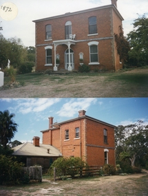 Stawell Historical Society Inc
Photograph, Armstrong’s Area Houses c 1990's -- 2 Photos -- Coloured
Residence Fountainhead Brewery Armstrong's Est. c 1872. The rear view photograph shows a more recent renovated building. Some evidence of demolition to rear of building (servants stairs etc.) Following notes taken from information in album 9 - "Compare earlier photos and note balcony etc. Later views, This photo early 2003. Owing to timber decay balcony was removed for safety. Finances permitting complete balcony will be replaced. Twin columns and iron lace are not original. Early description mentions statues in "niches" beside door. Female statue left is original. White pedestal at left was male stature damaged by a falling tree. Both statues were fountains." Photographs taken by Mr. Don Richard and held in Album 9b Armstrong’s Area.Two coloured photographs, of a brick double story building. The front view of the building has 4 windows and 2 doors. Two white columns at the entrance with decorative iron work support the roof of the porch with 2 white chairs and a table on top. Either side of the entrance door are 2 white wall indents "niches" with pot plants. The second photo show the back view of the two story building with a single story building attached that has a tin roof. A timber fence with a gate shows the side entrance to the single story building. 648M NHNN 8H01HPRO3 WIMMERA 1MHGINGstawell -
 St Kilda Historical Society
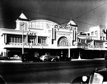
Photograph, St Moritz St Kilda - images collection #1, c1940s
... a demolition permit already issued. The building infamously suffered... a demolition permit already issued. The building infamously suffered ...The St. Moritz Ice Rink was a popular ice skating rink on The Esplanade, St. Kilda, Victoria. It operated between 1939–1981. As one of only two ice rinks in Melbourne in the 1940s and 1950s, it played a central role to the sport of ice hockey in Australia. Closed in 1982, it soon suffered a major fire and was then demolished, an event later seen as a major blow to the heritage of St Kilda. It was first built as the Wattle Path Palais de Danse in 1922, a very large dance hall, designed by architects Beaver & Purnell, The Wattle Path was the venue for the first all-Australian dance championship, and featured some of the best dance bands of Australia, as well as from America. Popular throughout the 1920s, it suffered due to the Great Depression, and closed in the early 1930s. From 1933-1936 the building became a film studio, Efftee Studios, for Frank W. Thring. In 1938, businessman Henry Hans "Harry" Kleiner announced that the Wattle Path would become an ice rink. He was sole proprietor until 1953, when he sold the business to J. Gordon and T. Molony, both champion skaters. Trade declined during the 1970s. The building was sold in 1980 to developers Hudson Conway and trucking magnate Lindsay Fox and was closed in early 1982. It was nominated to the Historic Buildings Preservation Council, but a majority of City of St Kilda councillors voted to oppose this action and uphold a demolition permit already issued. The building infamously suffered a fire later that year, leaving only the facades, which were demolished soon after. The site remained vacant until about 1991, when a mid-price hotel called the St Moritz was constructed. By 1993 it was simply called the Novotel St Kilda. The hotel closed in 2019 and was replaced by an apartment complex.black and white photographSt Moritz, St Kilda. Ice Skating. Caf�st moritz, st kilda, the esplanade, ice skating -
 Vision Australia
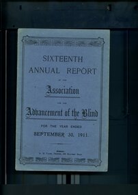
Administrative record - Text, Sixteenth Annual Report of the Association for the Advancement of the Blind 1911, 1911
Annual report of the Association for the Advancement of the Blind outlined activities and events over the year, including membership of 299, 1000 visits were paid during the year, the Public Works department erected a set of steps from the top of the cliff to the sands so that Home residents may be able to access the beach, Railway Permits will now also be honoured on the Prahran-Malvern Electric Tramway and Bay Excursion Steamers, a concert party toured to Egerton, Ballan, Bacchus Marsh, Myrniong and Toolern Vale for the dual purpose of raising awareness and funds for the Association, Mr A Solomon has been appointed as a second Collector to visit Country Towns and with the support of the wife of the Minister for Public Works, Miss Aston and Miss Munce waited on the Lady Mayoress of Melbourne, gave her full support to organise a fund to purchase the land and buildings in Mair Street for the Association.1 volume of printed material with some illustrationsassociation for the advancement of the blind, annual reports -
Kew Historical Society Inc
Journal, Kewriosity : June 1984
Mayoral Comment - Swedish hero honoured in Kew [Raoul Wallenberg] / Cr Jill O'Brien p1. The village without a name [Edgevale Road] / Barbara Giles p1. Billabong Club / p2. Wine bottling / p2. Sunday afternoon at Kew / p2. Kew Garden Club / p2. Native Plant Group / p2. Asian Evangelical Fellowship / p2. Early Planning for retirement / p2. The Rheumatism and Arthritis Association of Victoria / p2. Kew (Daytime) Garden Club / p2. Hyde Park Fellowship / p2. Penguin Club / p2. F.A.C.S. [Family and Community Services Programme / p3. New Residents Kits / p3. Parking permits for people with physical disabilities / p3. Occupational Therapist in Kew / p4. Physiotherapists / p4. Speech pathology / p4. Children's Services / p4. Area 10 Traffic Management / p5. Kew Historical Society happenings / p5. Community artists / p5. New Victoria building regulations / p6. Voting / p6. Safety [footpaths] / p6. Domestic noise / p6. Volunteers ["Gatehouse"]/ p7. Foster Care information [Inner East Foster Care] / p7. Kew Residents Group / p7. Black sheep and family crests [Kew Library, Genealogy] / p7. Infantile Paralysis [Poliomyelitis] / p7. Kew Community House News / Rhonda McCaw p8. Art Show / p8. Immunisation Sessions / p8. Parks and gardens / p8.Kewriosity was a local newsletter combining Kew Council and community news. It was published between November 1983 and June 1994, replacing an earlier Kewriosity [broad] Sheet (1979-84). In producing Kewriosity, Council aimed to provide a range of interesting and informative articles covering its deliberations and decision making, together with items of general interest and importance to the Kew community and information not generally available through daily media outlets.non-fictionMayoral Comment - Swedish hero honoured in Kew [Raoul Wallenberg] / Cr Jill O'Brien p1. The village without a name [Edgevale Road] / Barbara Giles p1. Billabong Club / p2. Wine bottling / p2. Sunday afternoon at Kew / p2. Kew Garden Club / p2. Native Plant Group / p2. Asian Evangelical Fellowship / p2. Early Planning for retirement / p2. The Rheumatism and Arthritis Association of Victoria / p2. Kew (Daytime) Garden Club / p2. Hyde Park Fellowship / p2. Penguin Club / p2. F.A.C.S. [Family and Community Services Programme / p3. New Residents Kits / p3. Parking permits for people with physical disabilities / p3. Occupational Therapist in Kew / p4. Physiotherapists / p4. Speech pathology / p4. Children's Services / p4. Area 10 Traffic Management / p5. Kew Historical Society happenings / p5. Community artists / p5. New Victoria building regulations / p6. Voting / p6. Safety [footpaths] / p6. Domestic noise / p6. Volunteers ["Gatehouse"]/ p7. Foster Care information [Inner East Foster Care] / p7. Kew Residents Group / p7. Black sheep and family crests [Kew Library, Genealogy] / p7. Infantile Paralysis [Poliomyelitis] / p7. Kew Community House News / Rhonda McCaw p8. Art Show / p8. Immunisation Sessions / p8. Parks and gardens / p8. publications -- city of kew (vic.), kewriosity, council newsletters, community newsletters -
Whitehorse Historical Society Inc.
Newspaper - Article, Permit for units, 15/09/1992
Nunawading's Council will allow the building of 3 units on the land of Nunawading's oldest resident's previous home of Miss Kit St Clai. Vernal Avenue residents have vigorously opposed the application.houses, vernal avenue, mitcham, st. clair, catherine, mckittrick, david, athan, savvas, plummer, jan, cooper, les -
Federation University Historical Collection
Document - Reports, Martin Westbrooke, Nanya Station
Nanya Station, owned and managed by the University of Ballarat (now Federation University Australia), was purchased with assistance from the Department of Environment and Heritage Government Caring for our Country program. Nanya Station is located in the Scotia country, west of the Darling Ana-Branch in far western New South Wales and consists of the Nanya Western Lands Pastoral Lease 3281 – Perpetual Leasehold Lot 1244 in Deposited Plan 762778, Parish of Winnebaga, County of Tara and part of Lot 1242 County of Windeyer. Nanya is within the tribal area of the Danggali Aboriginal people, a sub-group of the Barkindji. Many Aboriginal sites have been recorded adjacent to major rivers in the region providing evidence that these areas supported a large population. The Scotia region has one of the shortest stock grazing histories of western NSW. Along with five other Scotia properties, Nanya was created as a pastoral lease in 1927. The first European settlement on the land followed exploration of the area by Sturt and Eyre. In 1854, the Lake Victoria lease which encompassed this area comprised 465,000ha.included Scotia blocks 1, 2, 3 and 4, Amoskeag and Winnebaga which formed the area known as the Scotia. It was described as a region of thick mallee scrub, interspersed with bluebush flats and Belah woodland. In the 1920s artesian water was found and the dry Scotia country was surveyed and divided into six Homestead leases allocated by ballot (Withers 1989). All properties were approximately 30,000ha, with a recommended stocking level of 3,000 sheep. Winnebaga (renamed Nanya) was taken up by Gordon Cumming. He initially dug a dam near the southeast corner of the property. A larger ground tank and rudimentary dwelling at the site of the present complex was later established. An adjacent area was cleared and cropped to provide feed for the horses used in digging the earth tanks. The ruins of the original building are located between the shearing shed and Homestead Tank. A cottage was built in the 1930s and a more substantial Red Gum framed homestead in the early 1950s. The lease was held by Mr Gordon Cumming until 1984 when it was purchased by Mr Norm Scadding as an extension to the adjacent lease, Belvedere. It was sold in 1995 to Mr Rob Taylor of Waikerie then in 1999 to BeMax Pty. Ltd., a sand mining company. These last three owners all permitted use of the property by the University for teaching and research. The Centre for Environmental Management at the University of Ballarat had been involved in studies of flora and fauna in western New South Wales since 1988. Studies became concentrated on the Scotia region with its variety of intact ecosystems due to a short pastoral history. Of particular significance is a system of natural salt lakes of which the most extensive is the Scotia Discharge Complex located on Nanya Station. An extensive vegetation survey of the Scotia region Westbrooke et al. 1998) highlighted the significance of the area both in terms of the range of communities in relatively intact condition and the occurrence of species and communities of restricted distribution. Nearly 400 species were recorded of which nine had either not previously been recorded or have restricted distribution in western NSW. Twenty-two plant communities occur on Nanya Station of which two, Halosarcia lylei low open shrubland and Hemichroa diandra/Halosarcia/Frankenia low open shrubland, are dominated by species not previously recorded from NSW. H. lylei and Acacia loderi shrublands are listed as endangered under the NSW Threatened Species Conservation Act. As noted, the area has a relatively short grazing history and, due to the presence of large areas of mallee with a Triodia understorey and restricted water supplies, stocking rates have been low. The diversity of ecosystems in relatively intact condition and extensive areas of old growth mallee made Nanya a highly significant refuge for biological diversity. This factors led to the purchase of Nanya Station by the University of Ballarat in 2004 with the assistance of the Department of Environment and Heritage for the purposes of conservation, research and education. In 2010 the southern paddocks of Nagaella Station (10,000ha.) which lie along the northern boundary, were purchased with the assistance of Lower Murray Darling Catchment Management Authority and added to the Nanya lease to provide complete protection for the communities of the Nanya Discharge Complex and further high quality Malleefowl habitat. Four digital reports documents relating to Federation University's Nanya Station, Western New South Walesnanya station, scotia country, pastoral lease, winnebaga county, darling ana-branch, martin westbrooke, environmental education, nagaella station, lower murray darling catchment management authority, conservation research education, ian gribble, pat prevett, ian henderson, danggali -
 Eltham District Historical Society Inc
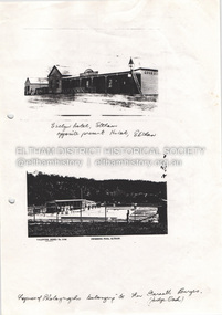
Document - Property Binder, 825 Main Road, Eltham
Photocopy photographs Evelyn Hotel Eltham and Eltham Swimming Pool, images owned by Garreth Burges. Elevations west, north, south, east, of proposed development by Germano Architects. Floor plans of proposed development by Germano Architects. Newspaper article: Council to reject apartments plan, Diamond Valley News, 20 May 1998, Nillumbik Council meeting, protestors against 25 unit development from Eltham Gateway Action Group. Newspaper public notice: Diamond Valley Leader 1 March 2006, Notice of Application for a Planning Permit, by Germano Architects. Newspaper article: Building at long last, Diamond Valley Leader, 3 September 2008, Nillumbik Council approved development plans.main road, eltham, property, businesses, evelyn hotel eltham, eltham swimming pool, eltham gateway action group, germano architects -
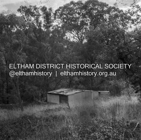 Eltham District Historical Society Inc
Negative - Photograph, J.A. McDonald, Road Reserve Housing, Mar. 1961
Shack built on road reserve without permit Most probably up on Simms Road, Kinglake Other areas where illegal shacks were built wer at the junction of Flat Rock Road and Cherry Tree Road, Hurstbridge. At times, Building Surveyor George E Newton would have to attend to these shacks for inspection and issue demolition ordersRecord of various Shire of Eltham infrastructure works undertaken during the period of 1952-1962 involving bridge and road reconstruction projects, sometimes with Eltham Shire Council Project Reference numbers quoted. It was during this period that a number of significant improvements were made to roads and new bridges constructed within the shire that remain in place as of present day (2022). In many situations, the photos provide a tangible visible record of infrastructure that existed throughout the early days of the Shire. The album was put together by or under the direction of the Shire Engineer, J.A. McDonald.infrastructure, shire of eltham, 1961-03, building surveyor, cherry tree road, flat rock road, george e. newton, houses, hurstbridge, kinglake, road reserve, road reserve housing, scan - 120 format 6x6 negative, shack, simms road -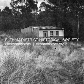
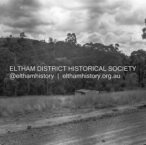 Eltham District Historical Society Inc
Negative - Photograph, J.A. McDonald, Road Reserve Housing, Mar. 1961
Shack built on road reserve without permit Most probably up on Simms Road, Kinglake Other areas where illegal shacks were built were at the junction of Flat Rock Road and Cherry Tree Road, Hurstbridge. At times, Building Surveyor George E Newton would have to attend to these shacks for inspection and issue demolition ordersRecord of various Shire of Eltham infrastructure works undertaken during the period of 1952-1962 involving bridge and road reconstruction projects, sometimes with Eltham Shire Council Project Reference numbers quoted. It was during this period that a number of significant improvements were made to roads and new bridges constructed within the shire that remain in place as of present day (2022). In many situations, the photos provide a tangible visible record of infrastructure that existed throughout the early days of the Shire. The album was put together by or under the direction of the Shire Engineer, J.A. McDonald.infrastructure, shire of eltham, 1961-03, building surveyor, cherry tree road, flat rock road, george e. newton, houses, hurstbridge, kinglake, road reserve, road reserve housing, scan - 120 format 6x6 negative, shack, simms road -
 Eltham District Historical Society Inc
Film - Video (DVD), Frank Stokes, Stokes Family, 1950-1977
Various family scenes taken from outside the family home on the southeast corner of the intersection of Nyora Road and Pitt Street with Eucalyptus Road. Also, scenes of the Stokes Orchard and equipment used, construction of water reservoir at the end of Nyora Road near Reynolds Road and Diosma Road as well as early stages of the Stokes Orchard housing development. Frank Stokes worked as a qualified accountant at Kennons leather factory in Burnley, while living at 1 Thomas Street, Mitcham. He suffered from migraines and wanted to go back to the land (he had previously worked on farms and orchards since coming to Australia in 1926 both in WA and Vic.). He first travelled to the district by train in July 1942 to find land with the intention to establish an orchard. By chance he met Arthur Bird of Bird Orchard (bounded by Pitt Street, Eucalyptus Road and Wattle Grove) and they got talking over their common interest. Arthur put Frank up for the night and pointed out the land, 158 acres- Taylor Estate- £900, part of Crown Allotment 15, Section 5, Parish of Nillumbik (CA15) somewhat diagonally opposite Bird Orchard. He applied through the Riverina Agency to purchase the land who in turn had to get permission from Canberra to sell as there was a new government regulation banning land sales except for immediate production. He obtained a loan on his Mitcham house of £600 @ 5% and paid £450 deposit with quarterly payments of £15 over 5 years. The title to the property was issued May 15, 1946. He was helped and advised by Arthur Bird who farmed the neighbouring orchard. Early 1943 he took possession and would catch the train out to Eltham on Fridays after work and began building a hut for shelter and to lock up tools. He was able to pay a neighbour (Hawkins) to help with clearing and fencing 25 acres and with a horse and single furrowed plow, planted approximately 2,500 fruit trees - cherries, peaches, plums, almonds, pears, apricots and lemons as well as a few apples and oranges; a massive job. A huge problem was hares and rabbits eating all the new buds off the tiny trees. As well as laying poison he painted the trees with a mixture of cow manure and lime. Often working by moonlight. It was extremely difficult to get wire and wire netting because of the war but after much effort he obtained a permit from the Agricultural Department for supplies in March 1944. In February 1945 he applied for a permit to build a “packing shed” as no house building allowed. It was to be 33 feet x 21 feet and cost £312. Constructed mostly from second-hand materials, which was hard to obtain, especially iron for roofing. Frank finished work at Kennons October 31, 1945, and in March 1946 he sold the Mitcham house for £1230 plus £170 for furniture. The family of five then moved into a very unfinished at Eltham, which was a struggle to weatherproof. Eventually rooms were divided off and lined with hessian bags and whitewashed. Their income was firewood (cut and sold), selling rockery stones and cut sweet bursaria. (It was discovered during the 1940s that Bursaria contained the sunscreen compound Aesculin. The RAAF utilised this compound from Bursaria during WW2 for pilots and gunners.) The orchard’s first fruit sale was a 1/2 case of Le Vanq peaches in December 1947 - 8 shillings. In 1956 plans for house were drawn and Glen Iris bricks purchased (1956 Olympic Rings variant). The building of the house commenced in 1957 - 12 feet of original packing shed removed – and was completed in 1959. Water was connected from newly built pressure storage on the property at the end of 1959 and the electricity connection for the first time at 3pm on April 29, 1960. In the mid-1970s the Shire of Eltham divided the orchard up into numerous rate-able parcel lots, which became unaffordable for Frank. Consequently, Stokes Orchard was turned into a housing development by Macquarie Builders and marketed as the Stokes Orchard Estate in two stages; Stage 1 encompassing Scarlet Ash Court, Ironbark Close and Peppermint Grove bounded by Nyora and Eucalyptus roads c.1976 and Stage 2 encompassing Stokes Place, Orchard Way, The Crest and The Lookout bound by Nyora and Diosma roads c.1979. The development of Orchard Way, The Crest and The Lookout did not proceed as planned due to the lack of the sewer along Diosma Road and so many of the proposed lots were incorporated into five-acre parcels instead. With the arrival of the sewer along Diosma Road many years later, most of these five-acre parcels have since been subdivided many times.Representative of the orchard growing areas of ElthamMP4 00:24:39; 426MB Digital file only - Digitised by EDHS from a DVD copy on loan from Beryl Bradbury (nee Stokes), daughter of Frank Stokes. 24 min duration compilation of home movie Super 8mm film shot by Frank Stokes brother-in-law.beryl bradbury (nee stokes) collection, frank stokes, nyora road, stokes orchard, stokes orchard estate, stokes place, video recording -
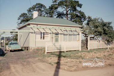 Eltham District Historical Society Inc
Photograph, Russell Yeoman, 66 Susan Street, Eltham, 1965c
Farmhouse built in the late 1800s by the Crozier Family. Subsequently owned by the Hill Family. Purchased in the early 1960s and by 1965 the property was owned by the Shire of Eltham. Employees of the Shire lived in the house. In 2006 the Shire of Nillumbik demolished the house which had been subject to extensive vandalism. In accordance with heritage advicde and a permit condition a sign was placed on the site outlining the history of the building. This was installed and remained in place till about 2016 when it was removed. The lands adjoins Alistair Knox Park. By 2010 the Eltham Skate Park was developed. In 2022 a major renovation and extension took place. Sources: EDHS Newsletter No 171 November 2006 and Google Street View. Digital file only; created from original colour positive slide transparencyeltham, streets, houses, susan street, alistair knox park, eltham skate park, russell yeoman collection, fc holden sedan -
 Eltham District Historical Society Inc
Register, Register of Significant Trees, Shire of Eltham, 1993, 1993c
In 1983, the National Trust advised the Shire of Eltham that it was investigating a number of trees within the shire which had been nominated for recording the Register of Significant Trees of Victoria. The trees involved were described in the Shire of Eltham Historical Society Newsletter No. 29, March 1983 as follows:- 1. Eucalyptus melliadora (Yellow box) . a) An outstanding mature specimen 42 metres high in Laughing Waters Road, Eltham. b) Another mature specimen in Arthurs Creek road, Hurstbridge is reported to be the tree under which the bushranger Robert Bourke was tied after he shot and killed Henry Hurst in 1866 . 2. Quercus robur (English Oak). a) "Donaldson's Oak", Donaldsons Road, Kangaroo Ground was planted by John Donaldson from seed collected from Windsor Great Park in 1878. b) "Wippells Oak". This now misshapen tree is located on the St. Andrews Road near the Kangaroo Ground Fire Station. Its origins may have been similar to Donaldson's Oak, and as a young tree it apparently slipped from higher up the hill during wet weather. Both oaks are of local historical importance. 3. Eucalyptus globulus (Blue Gum). A large mature specimen at the corner of the Kangaroo Ground-St. Andrews Road and Bakehouse Road, Panton Hill. 4. Plantanas acerifolia (Plane tree) A number of trees forming the Avenue of Honour to Eltham's First World War soldiers along Main Road between Dalton and Pitt Streets, Eltham. 5. Pinus canariensis (Canary Island Pine), Pinus pinea, (Stone pine) and Cedras altlantica, (Cedar) These trees are located at the Hurst family graves in the grounds of the Hurstbridge Pre-school Centre. In 1991 the Shire of Eltham introduced controls into its planning scheme to protect sites of architectural, historic or conservation interest and significant trees. The controls were approved by the Minister for Planning and Housing. As advised in the Shire of Eltham Historical Society Newsletter No. 78, May 1991, a planning permit is required to demolish or alter any listed building or to destroy, lop or remove any listed tree. Provision is made for comments to be obtained from the National Trust or Historic Buildings Council in considering any applications. The buildings and trees listed were: Buildings: 250 Bolton Street Eltham (former Walter Withers home) "Rosehill" - Bonds Road Lower Plenty St Andrews Church of England - St Andrews "Montsalvat" - Hillcrest Avenue Eltham St Margarets Church and former vicarage - Pitt Street Eltham Presbyterian Church - Kangaroo Ground Parks and Environment Office (former police quarters) Main Road Eltham Former Court House - Main Road Eltham "Shillinglaw Cottage" - Main Road Eltham "The Robins" - Kangaroo Ground Road Warrandyte Trees: "Donaldsons Oak" - Donaldsons Road Kangaroo Ground Yellow Box - Laughing Waters Road Eltham Yellow Box - Arthurs Creek Road Hurstbridge Wippells Oak - St Andrews Road Kanqaroo Road Pines and Cedar - Hurst family cemetery Greysharps Road Hurstbridge Yellow Box - Parsons Road Eltham A large Blue Gum at Panton Hill has been listed but has recently died (1991). In 1993 work by Council Parks and Environment staff and volunteers resulted in the preparation of a Significant Tree Register listing forty-one trees or groups of trees. According to Shire of Eltham Historical Society Newsletter No. 91, March 1993, a similar number remained to be assessed for inclusion in the register. There is a wide range of indigenous and planted trees on private and public land and extending through the Shire of Eltham from Lower Plenty to Kinglake. Most can be viewed from publicly accessible locations. The Significant Tree Register lists 41 trees or groups of trees throughout the Shire. It contains a wide range of naturally occurring and planted trees. They have been assessed according to eleven criteria including size, age, rarity, historical value and the like. The list includes large old Red Gums at Lower Plenty, historic Oaks at Kangaroo Ground and Mountain Ash at Kinglake. The register includes a set of slides showing each tree. Garry Bartlett of the Council's Parks and Environment Section and Faye Shepherd were extensively involved in establishment of the register (Newsletter No. 93, November 1993). In 1999 Niliumbik planners prepared an amendment to the Planning Scheme to provide protection for approximately 200 of the places listed in the heritage studies and also in the Significant Tree Register commenced by the Eltham Council (Eltham District Historical Society Newsletter No. 127, July 1999. In 2004, The Register of Significant Trees was presented to the Eltham District Historical Society by Nillumbik Shire Council as part of a wider collection of of its memorabilia of the former Eltham Shire Council (EDHS Newsletter No. 159, July 2004. Album of loose handmade paper sheets contained within a handmade slip cover constructed of handcrafted card with encapsulated flora material (flowers, vines, ferns) and tinted. Each page also contains an embedded/adhered fern leaf also tinted with lacqueur or similar, text as appropriate in ink by hand calligraphy. Each page also has a white protective sheet cut to size and adhered to back surface with sticky tape and folded over face of page. Pages variously have photographs and coloured masks adhered with a gum resin. Over time much of this resin has let go and photos/masks have been reattached using acid free archival safe adhesive. 15 pages 41 x 29 cm inclusive of 3 blank pages. Slip case 42 x 30 x 1 cm; face cover of slip case has broken off at left hand margin as insufficient depth/flexibility for contents.arthurs creek road, blue gum (eucalyptus globulus), canary island pine (pinus canariensis), couties road, donaldsons oak, donaldsons road, eltham, english oak (quercus robur), eucalyptus melliodora, graysharps road, hurst tree, hurstbridge, ironbark (eucalyptus tricarpa), ironbark hill, kangaroo ground, kangaroo ground-kinglake road, laughing waters road, panton hill hotel, panton hill, parsons road, significant trees register, sonia van bodegraven, sonjart, stone pine (pinus pinea). atlantic cedar (cedrus atlantica), wippells oak, yellow box gum (eucalyptus melliodora), yellow box gum -
 Eltham District Historical Society Inc
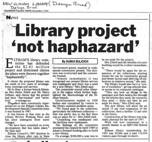
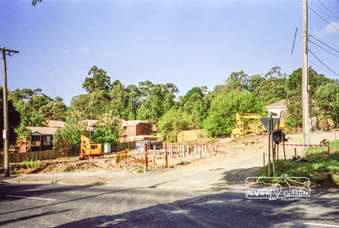
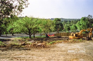
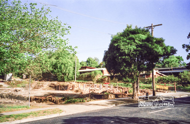
Folder, Eltham's new library opened 1994; local issues involved
Contents 1 Hand written note on cost of planning appeal 2 Determination re Appeal 1992/39742 by Rosalind Harris, Sigmund Jorgensen and Claire Fitzpatrick against granting of permit E92/481, 6 pages, 27 Jan 1993 3 Submission to the Appeal 1992/39742 by H. Gilham 4 Independent planning assessment for Appeal 1992/39742 by Tract Consultants, 13 pp including appendices, Jan 1993. 5 Letter from three ratepayers protesting against the siting of the proposed new library, 21 Jan 1993. 6 Statement of protest against library site by Claire Fitzpatrick, undated. 7 Impact study of proposed new library building by D.V.Bick, conservation architect, 2 October 1992. 8 assessment of impact of new library on historic significance of Shillinglaw Cottage, by National Trust of Australia, 22 October 1992. 9 Newspaper clipping, The Age, 2 Aug 1992, Scramble to revive capital works plans. 10 Newspaper clipping, DV News, 24 May 1988, New Angle to library funding 11 Newspaper clipping, DV News, 24 May 1988, Committee wants library views 12 Newspaper clipping, DV News, 24 May 1988, Library services in cash struggle 13 Library survey by Vic Ministry for the Arts, 14 December 1992 14 Newspaper clipping, DV News, 3 Aug 1992, Libraries in crisis 15 Newspaper clipping, DV News, 3 Aug 1992, Library funding editorial 16 Newspaper clipping, DV News, 7 Sept 1992, Library windfall 17 Newspaper clipping, DV News, 10 Aug 1992, Letters, Shire relies on rates to provide services, Cr J. Cohen 18 Newspaper clipping, DV News, 26 Oct 1992, Shire defends library plans. 19 Newspaper clipping, DV News, 26 Oct 1992, Letters, Library benefits whole community, J.Ilian, H. Gilham, R Harris 20 Letter to DV News by H. Gilham 20 October 1992, re library 21 Newspaper clipping, DV News, 19 October 1992, Letters, T. Malseed, Funds for region's jobless hijacked. 22 Newspaper clipping, DV News, 19 October 1992, Funds approved to build new library. 23 Newspaper clipping, DV News, 12 October 1992, Letters, Does Eltahm need a new mausoleum, M. Walker. 24 Newspaper clipping, DV News, 2 Nov 1992, Library project not haphazard. 25 Newspaper clipping, DV News, 9 Nov 1992, Letters, Library chose best architect for new project, Cr J. Cohen 26 Newspaper clipping, DV News, 16 Nov 1992, AAT to deal with library objections 27 Newspaper clipping, DV News, 30 Nov 1992, Public Notice, Registration for building trades 28 Newspaper clipping, DV News, 7 Dec 1992, Public Notice, Registration for building trades 29 Newspaper clipping, DV News, 7 Dec 1992, Letters, Find better site for library, S. Jorgensen, G.Verall 30 Newspaper clipping, DV News, 8 Feb 1993, Library given AAT aproval, and Extra funds should help make new facility more versatile 31 Newspaper clipping, DV News, 25 Jan 1993, Public Notice, Quotations invited for worls associated with new library 32 Newspaper clipping, DV News, 3 Feb 1993, Public Notice, Registration for building trades 33 Newspaper clipping, DV News, 4 January 1993, Letters, Bemused over library, C Fitzpatrick, R Henry 34 Newsletter Yarra Plenty RLS, Vol1, No 1, Your Public LibraryFolder/Booklet of various documents, mainly A4 size photocopiesHG Booklet 2administrative appeals tribunal, appeal, appeal 1992/39742, application e92/481, c. fitzpatrick, d. bick, diamond valley news, eltham library, eltham shire, g. verall, h. mccorkell, harry gilham, harry gilham collection, j. ilian, john cohen, m. walker, national trust (i. wight), r. harris, r. henry, s. jorgensen, shillinglaw cottage, parkland, rosalind harris, sigmund jorgensen, claire fitzpatrick -
 Eltham District Historical Society Inc
Photograph, Clearing land for Le Pine Funeral Home, cnr York Street and Main Road, Eltham, c.March 1998, 1998
Newsletter No. 116, September, 1997 846-848 MAIN ROAD ELTHAM Nillumbik Shire Council has granted a permit for a funeral parlour on land which includes this site at the corner of Main Road and York Street. The site contains an architect's office in a building which was formerly a shop and dwelling dating from the 1920's. The proposal requires demolition of this building which is one of the few remaining old shops which formed the rather spread out "town centre" of Eltham. Prior to making its decision the Council obtained a report from Graeme Butler and Associates, the heritage consultants who carried out Stage 1 of the Nillumbik Heritage Study. The report summarized the historical significance as follows:- "This brick comer shop with associated residence has potential local historical significance as a late 1920's grocer's shop, now much altered and one of only a few shops of that era left in Eltham's Main Road. This significance is qualified by the many changes. The other examples are better preserved and still function as shops." With this type of expert advice it is difficult to make a strong case for preservation of the building although, of course, it is a shame to see it demolished. The report includes details of the site itself and its history based on research carried out by Carlotta Kellaway. The building dates from the late 1920's when it was owned by C.R. Nicholls. From the early 1930's it was Charles Cockroft's grocery shop and he also ran a grain store there. According to his daughter, Edna Brown, he delivered groceries around the district taking his truck as far as Kangaroo Ground. In 1950 he shifted to Traralgon. Since then several different businesses have operated from the site including a bottle merchant and produce store. Conversion to the present office use involved alterations to the shop front and rebuilding the galvanized iron store at the rear. Newsletter 119 March 1998 In our Newsletter No. 116 it was reported that the former shop on the comer of Main Road and York Street, Eltham was to be demolished as part of a funeral parlour development. If you have passed the site recently you will have noticed that it has now been demolished - another part of the old Eltham township has disappeared.Roll of 35mm colour negative film, 6 strips Also photographic prints 10 x 15 cmKodak Gold 200-6a.r. warren, eltham feed store, le pine funeral home, main road, york street, c.r. nicholls, charles cockcroft, grocery store -
 Eltham District Historical Society Inc
Photograph, Liz Pidgeon, Heritage Excursion; The 1901 Eltham Railway Walk, 3 May 2014
Newsletter No. 216, May 2014 May Excursion – The 1901 Eltham Railway Walk The railway from Heidelberg to Eltham was opened in 1902. Over the previous year railway construction cut a curving swathe through Josiah Holloway’s 1851 Little Eltham subdivision. The survey plans for the railway show the owners and occupiers of land within Little Eltham affected by the railway alignment and for some distance each side. The plans show houses and other buildings but development at that time was rather sparse. Copies of these plans from the State Library of Victoria collection have been provided to the Society by Alan Sheehan. For our walk on 3rd May we intend to follow the railway from the Eltham Station to Ryans Road, which was the boundary of the adjoining Montmorency Farm. The return will be by way of nearby streets. Along the way we will discuss the details shown on the railway plans as well as more recent railway documents and photographs. At the conclusion and if time permits we can inspect the historical display at the Eltham Station. The walk is about 3 km in length and will take about 2.5 hours. It will start at 2 pm at the Eltham Railway Station car park (east/Main Road side) (Melway Ref. 21 J5).Born Digitalheritage excursion, activities, eltham district historical society, eltham railway station, eltham library, trestle bridge -
 Eltham District Historical Society Inc
Photograph, Liz Pidgeon, Heritage Excursion; The 1901 Eltham Railway Walk, 3 May 2014
Football match at Eltham Central Park between Eltham and Heidelberg Newsletter No. 216, May 2014 May Excursion – The 1901 Eltham Railway Walk The railway from Heidelberg to Eltham was opened in 1902. Over the previous year railway construction cut a curving swathe through Josiah Holloway’s 1851 Little Eltham subdivision. The survey plans for the railway show the owners and occupiers of land within Little Eltham affected by the railway alignment and for some distance each side. The plans show houses and other buildings but development at that time was rather sparse. Copies of these plans from the State Library of Victoria collection have been provided to the Society by Alan Sheehan. For our walk on 3rd May we intend to follow the railway from the Eltham Station to Ryans Road, which was the boundary of the adjoining Montmorency Farm. The return will be by way of nearby streets. Along the way we will discuss the details shown on the railway plans as well as more recent railway documents and photographs. At the conclusion and if time permits we can inspect the historical display at the Eltham Station. The walk is about 3 km in length and will take about 2.5 hours. It will start at 2 pm at the Eltham Railway Station car park (east/Main Road side) (Melway Ref. 21 J5).Born Digitalheritage excursion, activities, eltham district historical society, eltham railway station, eltham library, trestle bridge, eltham central park, football -
 Eltham District Historical Society Inc
Photograph, Liz Pidgeon, Heritage Excursion; The 1901 Eltham Railway Walk, 3 May 2014
Newsletter No. 216, May 2014 May Excursion – The 1901 Eltham Railway Walk The railway from Heidelberg to Eltham was opened in 1902. Over the previous year railway construction cut a curving swathe through Josiah Holloway’s 1851 Little Eltham subdivision. The survey plans for the railway show the owners and occupiers of land within Little Eltham affected by the railway alignment and for some distance each side. The plans show houses and other buildings but development at that time was rather sparse. Copies of these plans from the State Library of Victoria collection have been provided to the Society by Alan Sheehan. For our walk on 3rd May we intend to follow the railway from the Eltham Station to Ryans Road, which was the boundary of the adjoining Montmorency Farm. The return will be by way of nearby streets. Along the way we will discuss the details shown on the railway plans as well as more recent railway documents and photographs. At the conclusion and if time permits we can inspect the historical display at the Eltham Station. The walk is about 3 km in length and will take about 2.5 hours. It will start at 2 pm at the Eltham Railway Station car park (east/Main Road side) (Melway Ref. 21 J5).Born Digitalheritage excursion, activities, eltham district historical society, eltham railway station, eltham library, trestle bridge -
 Eltham District Historical Society Inc
Photograph, Liz Pidgeon, Heritage Excursion; The 1901 Eltham Railway Walk, 3 May 2014
Newsletter No. 216, May 2014 May Excursion – The 1901 Eltham Railway Walk The railway from Heidelberg to Eltham was opened in 1902. Over the previous year railway construction cut a curving swathe through Josiah Holloway’s 1851 Little Eltham subdivision. The survey plans for the railway show the owners and occupiers of land within Little Eltham affected by the railway alignment and for some distance each side. The plans show houses and other buildings but development at that time was rather sparse. Copies of these plans from the State Library of Victoria collection have been provided to the Society by Alan Sheehan. For our walk on 3rd May we intend to follow the railway from the Eltham Station to Ryans Road, which was the boundary of the adjoining Montmorency Farm. The return will be by way of nearby streets. Along the way we will discuss the details shown on the railway plans as well as more recent railway documents and photographs. At the conclusion and if time permits we can inspect the historical display at the Eltham Station. The walk is about 3 km in length and will take about 2.5 hours. It will start at 2 pm at the Eltham Railway Station car park (east/Main Road side) (Melway Ref. 21 J5).Born Digitalheritage excursion, activities, eltham district historical society, eltham railway station, eltham library, trestle bridge