Showing 199 items matching "building permits"
-
 Ringwood and District Historical Society
Letters, Heatherdale Pre-School Association: Building Opening, General letters, building permits etc. 1953, 1951-2
... Heatherdale Pre-School Association: Building Opening, General letters, building permits etc. 1953...Letters General plus 1952 Fair. Building permits. Equipment requirements. First year of operation 1953. ...Letters General plus 1952 Fair. Building permits. Equipment requirements. First year of operation 1953. ...Heatherdale Pre-School Association. First year of operation 1953. Location Yallourn Parade, Ringwood. Building Opening.Documents from Heatherdale Pre-School Association. Building Opening. Letters General plus 1952 Fair. Building permits. Equipment requirements. First year of operation 1953. Location Yallourn Parade, Ringwood.File and Letters -
 Phillip Island and District Historical Society Inc.
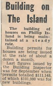
Newspaper Clipping
... ...building permits...Article about the building permits for Phillip Island issued at the rate of 12 a month....Phillip Island and District Historical Society Inc. phillip-island-and-the-bass-coast Article from a collection of newspaper clippings from October 1968 to July 1971 phillip island building permits Article about the building permits for Phillip Island issued at the rate of 12 a month. ...Article from a collection of newspaper clippings from October 1968 to July 1971Article about the building permits for Phillip Island issued at the rate of 12 a month.phillip island, building permits -
 Greensborough Historical Society
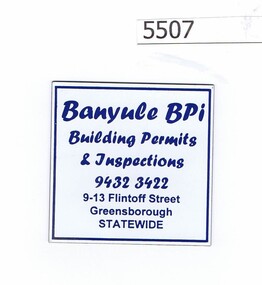
Refrigerator magnet, Banyule BPI, 2000c
... ...building permits..."Building permits and inspections", phone number and address at 9-13 Flintoff Street...Greensborough Historical Society 34A Glenauburn Road Lower Plenty Lower Plenty melbourne Business now operating from Level 3/1 Flintoff Street Greensborough 3088, Tel. 9433 7777 business cards building permits "Building permits and inspections", phone number and address at 9-13 Flintoff Street Refrigerator magnet, priinted in blue on white Banyule BPI Refrigerator magnet Banyule BPI ...Business now operating from Level 3/1 Flintoff Street Greensborough 3088, Tel. 9433 7777Refrigerator magnet, priinted in blue on white"Building permits and inspections", phone number and address at 9-13 Flintoff Streetbusiness cards, building permits -
 Wangaratta High School
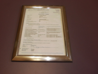
WHS Framed Certificate, 2010
... White Administration building occupancy permit, in a gold frame...LTD. Building Surveyors OCCUPANCY PERMIT...LTD. Building Surveyors OCCUPANCY PERMIT White Administration building occupancy permit, in a gold frame WHS Framed Certificate ...White Administration building occupancy permit, in a gold frameGRAEME BUCHAN & ASSOCIATES PTY. LTD. Building Surveyors OCCUPANCY PERMIT -
Glen Eira Historical Society
Book - GLEN EIRA GUIDE
... ... Building Permits...It includes information about Council meetings, the names and contact details of the six members of the Council, information about services offered by the Glen Eira Service Centre, the contact details for particular services offered by the Glen Eira City Council, information about rates and valuations, information about the building permit application process, information about waste management, and federal and state electoral maps. ...It includes information about Council meetings, the names and contact details of the six members of the Council, information about services offered by the Glen Eira Service Centre, the contact details for particular services offered by the Glen Eira City Council, information about rates and valuations, information about the building permit application process, information about waste management, and federal and state electoral maps. ...This file contains one item: 1/A copy of the 1999 edition of the Glen Eira guide. This magazine aims to provide readers with useful information for living and working within the City of Glen Eira. It is divided into five principal sections. The first section, titled Glen Eira City Council Information, provides information pertaining to the local government. It includes information about Council meetings, the names and contact details of the six members of the Council, information about services offered by the Glen Eira Service Centre, the contact details for particular services offered by the Glen Eira City Council, information about rates and valuations, information about the building permit application process, information about waste management, and federal and state electoral maps. The second section, titled Council and Community Resource Guide, consists of a list of the various local community facilities and organizations. The third section, titled City of Glen Eira Safe Food Guide, consists of a list of food venues nominated by the Glen Eira City Council Environmental Health Services Department for their commendable level of hygiene. The fourth section, titled City of Glen Eira Business Development Unit, provides information about the eponymous local government department, which is aimed at providing aid to local businesses. The fifth and final section, titled ‘Think Local, BUY LOCAL’ Guide, consists of a list of local businesses, grouped according to industry, to try and encourage the support thereof.glen eira, city of glen eira, glen eira city council, local government, local officials and employees, kennedy norman cr, mayors, public utilities, community services, local government departments, rates, local government, building permits, waste disposal, community groups, cultural structures and establishments, law and order, libraries, education, educational and research establishments, religious groups, clubs and associations, community centres, food, restaurants, businesses -
 Eltham District Historical Society Inc
Film - Video (VHS), Phil Burke et al, Shire of Eltham Grants Commsission Submission (Series 69, Item 7), 1993
... ...building permits...Shows scenes of assessing planning applications in these rural areas which takes significantly more time as well as other services provided such as Meals on Wheels, building permits, Ranger services. Provision of recreational facilities in hilly areas requires the acquisition of expensive river flats (views of cricket ground surrounded by hills) and where not possible, costly earthmoving required. ...Shows scenes of assessing planning applications in these rural areas which takes significantly more time as well as other services provided such as Meals on Wheels, building permits, Ranger services. Provision of recreational facilities in hilly areas requires the acquisition of expensive river flats (views of cricket ground surrounded by hills) and where not possible, costly earthmoving required. ...Shire of Eltham Archives: Series 69, Item 7 Opens with aerial views of the Shire, 85% of the shire covered by the Green wedge principal. Discusses the obligations required of the Shire to maintain the Green Wedge. The Shire covers over 27,000 hectares with a population in excess of 45,000 residents, more than 70% living in the southern 10% of the Shire in suburbs of Eltham, Montmorency, Lower Plenty and Research. 85% of the Shire in the more sparsely populated northern area which is covered by the Green Wedge. Council is committed to providing a parity of services to all residents such as garbage collection and maintenance of roads. Views of rubbish collection trucks in Montmorency. It is emphasised that the cost of these services in highly populated areas is relatively low whereas in the sparsely populated Green Wedge areas, considerable. There are hundreds of kilometres of roads throughout the Shire, many unmade and maintenance is high to check overhanging trees and erosion especially on the steep hills is expensive and disproportionate to servicing the population in the dense urban areas. Shows views of hilly gravel roads and graders at work maintaining them. Shows scenes of assessing planning applications in these rural areas which takes significantly more time as well as other services provided such as Meals on Wheels, building permits, Ranger services. Provision of recreational facilities in hilly areas requires the acquisition of expensive river flats (views of cricket ground surrounded by hills) and where not possible, costly earthmoving required. Also, views highlighting extensive tracks of natural habitat home to significant bird, animal and plant life. Shire emphasises its commitment highlighted by the Eltham Copper Butterfly which the Shire maintains small pockets of bushland to ensure its survival at significant expense (views of Pauline Toner Copper Butterfly Reserve.) Short interview with Pat Vaughan, Environmental Officer for the Shire discussing the Eltham Copper Butterfly who also mentions many other species in the Shire of high significance from bats to mammals to plants as well as the importance of the Green Wedge to Melbourne – the lungs of Melbourne - and ensuring the protection of very important habitat which requires a great deal of planning and management to look after. Views of Wingrove Park to emphasise this maintenance by machinery in some areas is too damaging and introduced species, etc must be removed by hand. Balancing the services and facilities expected by the community with the needs of the environment requires careful planning demands requires careful planning and the principals of the Green Wedge require constant attention in the face of growing need for housing. Director of Planning & Environment, Richard Allen advises there are approximately 1,300 planning permits and development applications each year ranging from simple subdivision, boundary realignments to further complicated non-urban developments for agricultural pursuits and the level of expertise required from architectural and engineering to land degradation, flora and fauna. Video finishes with aerial views and parklands, streetscapes and rural areas. VHS Video cassette Converted to MP4 file format 00:07:39; 89MBshire of eltham, video recording, shire of eltham archives, eltham shire council, eltham, building permits, cricket ground, development applications, eltham copper butterfly, garbage collection, graders, green wedge, lower plenty, meals on wheels, montmorency, pat vaughan, pauline toner reserve, planning applications, planning permits, ranger services, recreational facilities, research, richard allen, roads, rural areas, wingrove park, victoria grants commission -
Glen Eira Historical Society
Document - Glen Eira Residents Association
... ... Building Permits...Martens Cr. Building Permits Delegated Planning Committee (DPC) Steward Joy Brohier Peter Campbell Fliss Scutt Alex Ray Darren Hannah Brian St. ...Six items pertaining to Glen Eira Residents Asssociation Inc. 1/Two copies of the minutes of a Committee Meeting of Glen Eira Residents Association Inc., held on 04/12/2001. The minutes cover a range of routine meeting items, as well as the postponed release of the Princes Park Master Plans and the proposed construction of car parks at Caulfield Racecourse. 2/A copy of Glen Eira Residents’ Association Inc.’s 30/05/2003 newsletter, notifying members of matters presently before Glen Eira City Council for purposes of evaluation. Matters include an admonishment to the Council to sort out anomalies between the C25 Amendment (80/20 Plan) and the Melbourne 2030 Plan, the success at convincing the Ministerial panel to adopt GERA’s views regarding the C14 Council Plan for the Caulfield Racecourse, a request for information from the Council regarding the previous year’s rate increase, a request for information from the Council regarding spending on planning for improvements to Princes Park, a call for the Council to improve its consultative procedures, a recommendation that the purpose of Glen Eira News be expanded to the making of suggestions for city improvement, and a notification of the measures implemented to improve the visibility of Caulfield Racecourse’s usability by the public. Includes a black-and-white photograph of Orrong Road, Elsternwick, illustrating what Glen Eira’s roads would look like if lined with trees, which was excluded from Glen Eira News on account of a current prohibition on the making of suggestions for city improvements. 3/Four copies of a booklet entitled ‘A Short Guide to Planning Procedures’, composed 08/2006, which endeavours to explain, as concisely as possible, the methodology by which Glen Eira City Council approves real estate developments and issues planning permits. 4/A booklet containing the minutes of the 05/10/2009 Annual General Meeting of Glen Eira Residents’ Association Inc. Details both routine items and more specific matters of discussion, such as inappropriate charges on the part of the Glen Eira City Council and the proposed inception of a questionnaire to evaluate local residents’ opinion of the Council. 5/A booklet announcing the 07/10/2010 Annual General Meeting of Glen Eira Residents’ Association Inc. at St. John’s Uniting Church, Elsternwick. Front cover details agenda and contains four colour photographs pertaining to public transport (buses, trams, trains) within the city. Interior features president Don Dunstan reflecting on issues relevant to GERA occurring over the preceding twelve months, with an emphasis on the dubious behaviour of the City Council, as well as two colour photographs: one of Dunstan himself and one of traffic at Elsternwick Junction. The rear cover contains the Financial Statement presented to the Meeting. 6Two copies of a printout of an article from the website of Glen Eira Residents’ Association Inc., accessed 19/06/2012, explaining the affects wrought as a result of the implementation of Planning Scheme Amendment C87. Said amendment changes the Planning Scheme protecting neighbourhood character by replacing the previous Significant Character Area (SCA) designation with the new designations of Neighbourhood Character Overlay (NCO) and Design and Development Overlay (DDO). In developing the Amendment, Glen Eira City Council commissioned Planisphere to procure the Planisphere Final Report, in which recommendations regarding the expansion, creation and deletion of SCAs were offered. The article contains a summary of said recommendations.glen eira residents’ association inc., clubs and associations, glen eira, meetings, minutes, campbell jack, dunstan don, marwick geoff, pleydell max, teseriero dominic, robins kevin, princes park, south caulfield, glen eira city council, local government, councillors, brennan martin, victorian local government association (vlga), erlich mayor, project manikato, caulfield racecourse, caulfield racecourse flat, racecourses, parks, car parks, kennedy cr., kennedy norman mr., crown land, glen eira road, rippon lea, c25 plan (80/20), melbourne 2030 plan, c14 council plan, rates, orrong road, elsternwick, trees, station street, caulfield north, neerim road, glenhuntly, glenhuntly park, orrong ward, grossbard cr., martens cr., building permits, delegated planning committee (dpc), steward joy, brohier peter, campbell fliss, scutt alex, ray darren, hannah brian, st. john’s uniting church, mees paul dr., elsternwick club, sandham street, melbourne weekly bayside, glen eira debates, walsh investigation, whelen investigation, forge cheryl cr., whiteside helen mayor, save our suburbs (sos), walsh mary, walsh kevin, french christine, elsternwick junction, planning scheme, planning scheme amendment c87, significant character areas (scas), planisphere final report, oakdene crescent, carnegie, blackwood street, housing diversity areas, urandaline grove, caulfield, normanby road/park crescent, kambrook road, balaclava road, hawthorn road tramway estate, caulfield south, ulupna road, ormond, murray street, prentice street, kambea grove, chestnut street, mcpherson avenue, queens avenue, caulfield east, derby crescent, clarinda street, st. james parade/downshire road, exhibition street, mckinnon, field street, boyd park, murrumbeena, lindsay avenue, lydson street -
Glen Eira Historical Society
Plan - Mount Scopus College, St. Kilda East
... ... Building Permits...Kilda East City of Caulfield Mayfield Street Talbot Avenue Floyd Jeff Building Permits Planning Act Shaw House M.M.B.W. ...A copy of the amended Planning brief for the development of Mount Scopus College dated 24/10/1982. It includes a covering letter listing the amendments. The planning brief describes the school’s facilities, classrooms, playground and the planned development of the school. It includes a site plan and an architect’s illustration of the proposed development.mount scopus college, st. kilda east, city of caulfield, mayfield street, talbot avenue, floyd jeff, building permits, planning act, shaw house, m.m.b.w. planning scheme, classrooms, kindergarten, playgrounds, library, multipurpose hall, car parking, students, teachers, staff, secondary school, primary school, synagogue, architects, syman justin and bialek, site plan, hall, building development, education department, town and country planning board, brick, zoning, traffic, property, landscape planning, planting, fence -
Glen Eira Historical Society
Letter - O’Neill College, Nagle Avenue, 2, Elsternwick
... ... Building permits...Gardenvale Railway Station Presentation Novitiate Auctions Catholic Schools Convents Nuns Colleges School houses Building Construction Building permits Public Health Department O'Neill College O'Neill College Estate Elsternwick Railway Stations Brentani Avenue Caulfield City Council Letter O’Neill College, Nagle Avenue, 2, Elsternwick ...2 articles related to O’Neill College. Photocopy of advertising leaflet for the auction of house- blocks, on the O’Neill College Estate, Elsternwick Auction held 08/04/1922. Copies of 4 letters dated 17/07/1936 to 12/04/1937 from the Victorian Public Health Dept. to the Mother Superior, O’Neill College, regarding alterations to the college buildings.o’ neill college estate, elsternwick, burke t. m., subdivisions, railway crescent, nagle avenue, denver court, robinson c.h., gardenvale railway station, presentation novitiate, auctions, catholic schools, convents, nuns, colleges, school houses, building construction, building permits, public health department, o'neill college, o'neill college estate, elsternwick railway stations, brentani avenue, caulfield city council -
Glen Eira Historical Society
Article - Helenslea, Shelford CEGGS
... ... Building permits...Shelford Grammar School Caulfield Council Hood Crescent Chessell Pam Lyall Peter Friedmann Helen Anderson Sandy Shelford Anglican Girls School Caulfield North Chessell Pamela Helenslea Road Schools Building permits Child care Protest groups Child minding centre Article Helenslea, Shelford CEGGS ...Two photocopied articles concerning preliminary approval granted by Caulfield Council to Shelford Grammar School for a child minding centre in Hood Crescent and objections to this proposal. One article comes from the Southern Cross of 19/08/1992 and the other comes from the MCP of 24/08/1992.shelford grammar school, caulfield council, hood crescent, chessell pam, lyall peter, friedmann helen, anderson sandy, shelford anglican girls school, caulfield north, chessell pamela, helenslea road, schools, building permits, child care, protest groups, child minding centre -
 Greensborough Historical Society
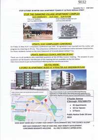
Document - Planning Document, Diamond Village Apartment Complex, 2019
... ...building permits...Greensborough Historical Society 34A Glenauburn Road Lower Plenty Lower Plenty melbourne A collection of documents discussing opposition to the Diamond Valley Apartment Complex, a high-rise apartment development planned for Nepean Street Greensborough. diamond village apartment complex building permits nepean street greensborough 13 pages of Text with coloured photographs and map Diamond Village Apartment Complex Document Planning Document ...A collection of documents discussing opposition to the Diamond Valley Apartment Complex, a high-rise apartment development planned for Nepean Street Greensborough.13 pages of Text with coloured photographs and mapdiamond village apartment complex, building permits, nepean street greensborough -
Whitehorse Historical Society Inc.
Article, VCAT approves 14 storeys, 2004
... ...Building permits...Whitehorse Historical Society Inc. 2-10 Deep Creek Road Mitcham melbourne Melbourne 2030 Building permits Colombo Street Mitcham Aubrey Chris High-rise buildings Councillor Chris Aubrey stated that this Council and the whole community felt let down when VCAT approved a 14 storey tower in Mitcham. ...Councillor Chris Aubrey stated that this Council and the whole community felt let down when VCAT approved a 14 storey tower in Mitcham.Councillor Chris Aubrey stated that this Council and the whole community felt let down when VCAT approved a 14 storey tower in Mitcham.Councillor Chris Aubrey stated that this Council and the whole community felt let down when VCAT approved a 14 storey tower in Mitcham.melbourne 2030, building permits, colombo street, mitcham, aubrey, chris, high-rise buildings -
Whitehorse Historical Society Inc.
Article, Call to end tower power, 2004
... ...Building permits...Whitehorse Historical Society Inc. 2-10 Deep Creek Road Mitcham melbourne City of Whitehorse Building permits Mitcham Residents' Group Hogg Tony Arrowsmith Valda Bilston John Treacy Peter Colombo Street Mitcham High-rise buildings Opponents of the Mitcham towers are unhappy that the Whitehorse Council failed to make a decision on the development of the Mitcham buildings incl. photos Opponents of the Mitcham towers are unhappy that the Whitehorse Council failed to make a decision on the development of the Mitcham buildings incl. photos Call to end tower power Article Article ...Opponents of the Mitcham towers are unhappy that the Whitehorse Council failed to make a decision on the development of the Mitcham buildings incl. photosOpponents of the Mitcham towers are unhappy that the Whitehorse Council failed to make a decision on the development of the Mitcham buildings incl. photosOpponents of the Mitcham towers are unhappy that the Whitehorse Council failed to make a decision on the development of the Mitcham buildings incl. photoscity of whitehorse, building permits, mitcham residents' group, hogg, tony, arrowsmith, valda, bilston, john, treacy, peter, colombo street, mitcham, high-rise buildings -
Whitehorse Historical Society Inc.
Article, Tougher planning power for councils, 2004
... ...Building permits...Whitehorse Historical Society Inc. 2-10 Deep Creek Road Mitcham melbourne Many lobby groups disagree with the decision Colombo Street Mitcham Building permits Mitcham Residents' Group Hogg Tony High-rise buildings VCAT (the planning appeals tribunal) approved dual apartment towers in Colombo Street Mitcham. ...VCAT (the planning appeals tribunal) approved dual apartment towers in Colombo Street Mitcham.VCAT (the planning appeals tribunal) approved dual apartment towers in Colombo Street Mitcham. Many lobby groups disagree with the decisionVCAT (the planning appeals tribunal) approved dual apartment towers in Colombo Street Mitcham. colombo street, mitcham, building permits, mitcham residents' group, hogg, tony, high-rise buildings -
Whitehorse Historical Society Inc.
Article, Nuna rallies for new fight, 1995, 1999
... ...Building Permits...City of Whitehorse Glen Ebor Avenue Blackburn Building Permits Residential Development Uhl Jean Article describing the change in building regulations to allow 'low-intensity and density' housing . ...Article describing the change in building regulations to allow 'low-intensity and density' housing .Article describing the change in building regulations to allow 'low-intensity and density' housing . Residents objected to the change as they saw it as a threat to the environment. Prefers specifically to units being built in Glen Ebor Avenue. Note attached in 1999 by Jean Uhl on consequent building of the units and their effect.Article describing the change in building regulations to allow 'low-intensity and density' housing .city of whitehorse, glen ebor avenue, blackburn, building permits, residential development, uhl, jean -
 Queen Victoria Women's Centre
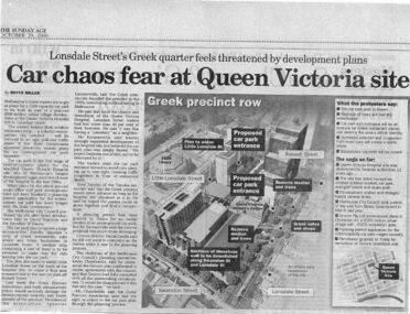
Newspaper excerpt, The Sunday Age, Car Chaos fear at Queen Victoria Site: Lonsdale Street's Greek quarter feels threatened by development plans, 29 October 2000
... ...building permits...Queen Victoria Women's Centre 210 Lonsdale Street Melbourne melbourne building construction building permits historic building Newspaper excerpt from The Sunday Age. ...Newspaper excerpt from The Sunday Age. Page 5 and a smaller introduction probably from the front page. Smaller excerpt colour photo of blue-stone and cast-iron wall which was to be demolished. Larger excerpt, a black and white aerial view of QVWC and the block where it is situated. building construction, building permits, historic building -
Canterbury History Group
Document - Request for further information - building application, 1986
... ... Building Permits...Wilkins Pty Ltd City Of Camberwell Building Permits Lawn Bowls Notice from the City of Camberwell for further information for a Building Application for work at Canterbury Bowling Club premises. ...Notice from the City of Camberwell for further information for a Building Application for work at Canterbury Bowling Club premises.canterbury, canterbury bowling club, kendall street, k. j. g. wilkins pty ltd, city of camberwell, building permits, lawn bowls -
Federation University Historical Collection
Document, City of Ballarat - Building Permit for Grant Street, South Side, East of Armstrong Street
... City of Ballarat - Building Permit for Grant Street, South Side, East of Armstrong Street......Building Permit...Pale blue/green A4 document - City of Ballarat - Building Permit for Grant Street, South Side, East of Armstrong Street issued to the School of Mines Ballarart...Barker Library (top floor) Mount Helen goldfields School of Mines Ballarat, is a predecessor of Federation University City of Ballarat Ballarat School of Mines The Ballarat School of Mines and Industries J.B. Menhennet Building Permit Recreation Building Number stamp on top right hand corner Pale blue/green A4 document - City of Ballarat - Building Permit for Grant Street, South Side, East of Armstrong Street issued to the School of Mines Ballarart City of Ballarat - Building Permit for Grant Street, South Side, East of Armstrong Street Document ...School of Mines Ballarat, is a predecessor of Federation UniversityPale blue/green A4 document - City of Ballarat - Building Permit for Grant Street, South Side, East of Armstrong Street issued to the School of Mines BallarartNumber stamp on top right hand corner city of ballarat, ballarat school of mines, the ballarat school of mines and industries, j.b. menhennet, building permit, recreation building -
 Sunshine and District Historical Society Incorporated
Archive - City Of Sunshine Statistics 1966
... City of Sunshine Staff Private Street Construction Development of Playing Fields Infant Welfare Centres and Pre-School Centres Rate Revenue Building Permits Income Population Loan Liabilities...City of Sunshine City of Sunshine Staff Private Street Construction Development of Playing Fields Infant Welfare Centres and Pre-School Centres Rate Revenue Building Permits Income Population Loan Liabilities Foolscap typed report Archive City Of Sunshine Statistics 1966 ...In 1966, at the time of the opening and inspection of the new Municipal Offices in Alexandra Avenue Sunshine, the Council produced these interesting statistics depicting the growth of the Municipality in the Post World War 2 period.City of Sunshine Staff Private Street Construction Development of Playing Fields Infant Welfare Centres and Pre-School Centres Rate Revenue Building Permits Income Population Loan Liabilitiescity of sunshine -
 Whitehorse Historical Society Inc.
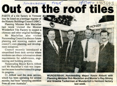
Article, Out on the roof tiles, 1994
... City of Nunawading has recently introduced a front desk service where residents can obtain information about requirements for subdivisions, engineering and building permits....City of Nunawading has recently introduced a front desk service where residents can obtain information about requirements for subdivisions, engineering and building permits. Out on the roof tiles Article Article ...Parts of Monier Wunderlich tile factory in Vermont may be listed on a heritage register of the Historic Buildings Council.Parts of Monier Wunderlich tile factory in Vermont may be listed on a heritage register of the Historic Buildings Council. City of Nunawading has recently introduced a front desk service where residents can obtain information about requirements for subdivisions, engineering and building permits.Parts of Monier Wunderlich tile factory in Vermont may be listed on a heritage register of the Historic Buildings Council. tile factories, monier wunderlich tile factory, historic buildings, abbott, kevin, maclellan, rob, strong, ray, tuckerman, graeme -
Bendigo Historical Society Inc.
Document - Application for a Building Permit, 1959
... Application for a Building Permit ...city of bendigo building permit...Application for a Building Permit for 26 Raglan Street Bendigo 1. ...Document Application for a Building Permit ...Parry CollectionApplication for a Building Permit for 26 Raglan Street Bendigo 1. Application for Permit to the City of Bendigo by Mr J Parry 3 Yandoit St Bendigo for a cement shed as detailed. The receipt is attached for 10 shillings. 2. Hand Drawn plan of the laundry (Shed) proposed for Mr J Oudijn, scale 1/4 inch = 1 foot, signed and stamped by the City of Bendigo.history, bendigo, j s parry collection, city of bendigo building permit -
 Ballarat Tramway Museum
Document - Personal Papers, Warren Doubleday, "Depot Extensions", "First Report of the Expert Panel on Tramway Museum Safety Standards to the Chairman and Members of the Council of Tramway Museums of Australasia", mid 1970's
... Set of personal papers of Warren Doubleday concerning the extension of the original depot of the BTPS in the mid 1970s' Includes drawings, sketches, Letters In and Out, Specifications, calculations, Building Permit and General Papers. This includes plans of Bungaree, list of drawings held by Bill Kingsley at the time, and a report dated 25/4/1977 titled "First Report of the Expert Panel on Tramway Museum Safety Standards to the Chairman and Members of the Council of Tramway Museums of Australasia"....Yields information about the design and construction of the depot extensions for the BTPS in the mid 1970's and has a strong association with Warren Doubleday Trams tramways BTPS Depot Extensions COTMA Safety Set of personal papers of Warren Doubleday concerning the extension of the original depot of the BTPS in the mid 1970s' Includes drawings, sketches, Letters In and Out, Specifications, calculations, Building Permit and General Papers. This includes plans of Bungaree, list of drawings held by Bill Kingsley at the time, and a report dated 25/4/1977 titled "First Report of the Expert Panel on Tramway Museum Safety Standards to the Chairman and Members of the Council of Tramway Museums of Australasia". ...Yields information about the design and construction of the depot extensions for the BTPS in the mid 1970's and has a strong association with Warren DoubledaySet of personal papers of Warren Doubleday concerning the extension of the original depot of the BTPS in the mid 1970s' Includes drawings, sketches, Letters In and Out, Specifications, calculations, Building Permit and General Papers. This includes plans of Bungaree, list of drawings held by Bill Kingsley at the time, and a report dated 25/4/1977 titled "First Report of the Expert Panel on Tramway Museum Safety Standards to the Chairman and Members of the Council of Tramway Museums of Australasia".trams, tramways, btps, depot extensions, cotma, safety -
 Sunshine and District Historical Society Incorporated
Archive - Gwen Mousley Collection - Plans for buildings, for St John's Deer Park - church hall & kindergarten,, 16/5/1951 & proposed toilet block for St John's, 9/7/74
... Folded plans 1) Blueprint + typed letter from Building Directorate, State of Victoria, 16 May 1951, issued to Church of England Trusts Corporation, Diocese of Melbourne, via Shire of Braybrook - building permit Church hall & kindergarten to be constructed of Mount Gambier limstone with an asbestos cement roof. 2) Plans on white paper re toilet block for St John's Church of England, Miles St, Deer Park prepared by B.& D. ...Kayser Folded plans 1) Blueprint + typed letter from Building Directorate, State of Victoria, 16 May 1951, issued to Church of England Trusts Corporation, Diocese of Melbourne, via Shire of Braybrook - building permit Church hall & kindergarten to be constructed of Mount Gambier limstone with an asbestos cement roof. 2) Plans on white paper re toilet block for St John's Church of England, Miles St, Deer Park prepared by B.& D. ...Signature of church wardens on 1951 blueprint: Chas F. Kennedy & S.A. Kayserst. johns church, deer park, miles street, church -
Surrey Hills Historical Society Collection
Document - Plans, Andrew Wood, Building plans associated with Andrew Wood, builder of Surrey Hills, 1920s
... .1: Specifications & plans for the kinder hall, Howard Street, Mont Albert for the Mont Albert Methodist Church, May 1925 .2 Plans for a proposed villa, 48 Payne's Paddock, Highfield Road, Canterbury for Mr E H Sillifant, dated 22/4/1920 .3 Plans for a timber villa for Mrs J A Burchell at Riversdale Road, Surrey Hills, stamped 9/5/1922 .4 Plan of a garage at Victoria avenue, Canterbury; stamped 14/2/1922 .5 Building permit & receipt from City of Hawthorn re Lot 16 Homebush Crescent; dated 7/4/1925 .6 Plans for a concrete house at Camberwell for Mr H W Field ...Andrew Wood builders Box Hill Cemetery kindergartens Mont Albert Methodist Church building plans Highfield Road Ernest Horatio Sillifant Victoria Avenue Canterbury Lot 16 Homebush Crescent Californian bungalows H W Field .1: Specifications & plans for the kinder hall, Howard Street, Mont Albert for the Mont Albert Methodist Church, May 1925 .2 Plans for a proposed villa, 48 Payne's Paddock, Highfield Road, Canterbury for Mr E H Sillifant, dated 22/4/1920 .3 Plans for a timber villa for Mrs J A Burchell at Riversdale Road, Surrey Hills, stamped 9/5/1922 .4 Plan of a garage at Victoria avenue, Canterbury; stamped 14/2/1922 .5 Building permit & receipt from City of Hawthorn re Lot 16 Homebush Crescent; dated 7/4/1925 .6 Plans for a concrete house at Camberwell for Mr H W Field Building plans associated with Andrew Wood, builder of Surrey Hills Document Plans Andrew Wood Robin Kelly Peter Bray ...These plans were associated with Mr Andrew Wood, a contract builder who worked in the 1920s and built many Californian bungalows in Surrey Hills and surrounding suburbs. Andrew Wood was born in Chiltern in 1861 to Andrew and Ellen Wood (MS: Green). His father had emigrated from Falkirk, Scotland. As a young man Andrew worked as a carpenter in the mines in South Africa (c 1899). He married Eleanor Agnes Stuchbery in Hamilton, Victoria in May 1901. They had 5 children - Doris (M Roberts), Robert Andrew, Donald Allen, Jean (M Cowan), and Gwenyth (M Bray). The first 2 children were born in Hawthorn; the other 3 in Surrey Hills. The family home at 286 Canterbury Road, Surrey Hills (on the corner of Middlesex Road) was built by Andrew. Andrew died in 1940; Eleanor died in 1977, aged 100 years. After Eleanor's death the house was sold and demolished. Surrey Lighting was established on the site. Gwenyth May Wood (3 May 1917, Surrey Hills - 5 Jan 2004) married Leslie David Charles Bray (1921-1983). Gwenyth was the donor's mother. Andrew, Eleanor and one son Robert are buried in Box Hill Cemetery - B-071-0028. .1: Specifications & plans for the kinder hall, Howard Street, Mont Albert for the Mont Albert Methodist Church, May 1925 .2 Plans for a proposed villa, 48 Payne's Paddock, Highfield Road, Canterbury for Mr E H Sillifant, dated 22/4/1920 .3 Plans for a timber villa for Mrs J A Burchell at Riversdale Road, Surrey Hills, stamped 9/5/1922 .4 Plan of a garage at Victoria avenue, Canterbury; stamped 14/2/1922 .5 Building permit & receipt from City of Hawthorn re Lot 16 Homebush Crescent; dated 7/4/1925 .6 Plans for a concrete house at Camberwell for Mr H W Field andrew wood, builders, box hill cemetery, kindergartens, mont albert methodist church, building plans, highfield road, ernest horatio sillifant, victoria avenue canterbury, lot 16 homebush crescent, californian bungalows, h w field -
 Wonga Park Community Cottage History Group
Document - Building and Scaffolding Permit, issued 22/3/1968 for the extension to Beagley's shop in Wonga Park
... Building and Scaffolding Permit...22/3/1968 Shire of Lillydale Building and Scaffolding Permit for extension to Beagley’s shop...Wonga Park Community Cottage History Group Unit 1, 9 – 13 Old Yarra Road Wonga Park melbourne 22/3/1968 Shire of Lillydale Building and Scaffolding Permit for extension to Beagley’s shop issued 22/3/1968 for the extension to Beagley's shop in Wonga Park Document Building and Scaffolding Permit ...22/3/1968 Shire of Lillydale Building and Scaffolding Permit for extension to Beagley’s shop -
 Eltham District Historical Society Inc
Register, Building Permit Register, Shire of Eltham, 1949-1960
... Building Permit Register, Shire of Eltham......building permit register...Red fabric in centre of front cover with "Building Permit Register - Shire of Eltham" lightly embossed with silver print. 39.0 x 52.5 x 6.5 cm Arnall & Jackson label on inside end sheets ( both ends), Printers, Lithographers, Bookbinders, Publishers, Manufacturing Stationers, 115 Barkly St. ...Typically, last three columns not filled in. 326 pages arranged in Alphabetical tabs; 133 pages with entries. Building Permit Register, Shire of Eltham Register ...Register Book, Hard cover, tan suede leather bound spine and corners on both covers, with green fabric on 5mm thick covers. Red fabric in centre of front cover with "Building Permit Register - Shire of Eltham" lightly embossed with silver print. 39.0 x 52.5 x 6.5 cm Arnall & Jackson label on inside end sheets ( both ends), Printers, Lithographers, Bookbinders, Publishers, Manufacturing Stationers, 115 Barkly St. West, Brunswick, Repeat Order No. A27956 Special print with each page headed with "Shire of Eltham", divide into columns of Date, Description, Lot No., Locality, L.P. or C.A., Riding, Cost, Owner name and address, Builder name and address, Application, Permit No. Commenced, Completed, Capital Value, N.A.V. Typically, last three columns not filled in. 326 pages arranged in Alphabetical tabs; 133 pages with entries. Label adhered to front cover "Series 67 Item 79"shire of eltham archives, building permit register, shire of eltham -
 Eltham District Historical Society Inc
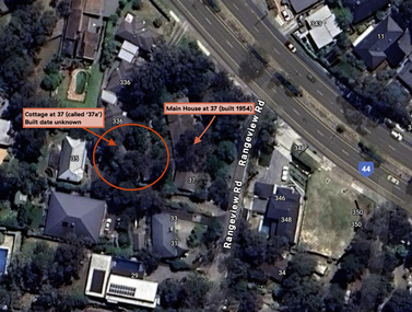
Document - Property Binder, 338 Main Road, Lower Plenty (also 37 Rangeview Road), March 2025
... for this studio was found in the Building Permit Register, Shire of Eltham, 1949-1960. ... for this studio was found in the Building Permit Register, Shire of Eltham, 1949-1960. ...EDHS_03095-338 | EDHS_08635-37 338 Main Road Lower Plenty | 37 Rangeview Road, Lower Plenty Original Mudbrick cottage and studio designed and built by Eltham artist, David Alan Newbury See also EDHS_06090 David Newbury (Artist) David Newbury was married to Clare Margaret Newbury. According to the 1954 Electoral Roll they were living at 36A Murphy Street, South Yarra however around 1953 they purchased Lots 3 and 4 of Main Road Lot Plan LP 23911 in Lower Plenty. A building permit, No. 71, was issued 8 December 1953 for a 5-room house of Vertical Board construction, cost £2,840, builder L. Williams, owner D. Newbury of 36 Murphy Cl., South Yarra. The large house was in fact mostly built of mudbrick, the construction method was only just becoming recognised as an acceptable form in the late 1940s for issuance of a building permit. The house was commenced in 1954, designed by David Newbury and built by David Newbury, Horrie Judd and others. Information from Newbury family friends suggests that a second mudbrick building was constructed in the late 1950s, early 1960s for use as an artist studio by Newbury. The building was connected directly to the water mains at the time and was made suitable for living accommodation during the period Newbury was teaching at Bendigo. Apparently he and Claire rented out the main house during their time in Bendigo and would reside in the studio when visiting Melbourne. No permit for this studio was found in the Building Permit Register, Shire of Eltham, 1949-1960. The last recorded entries in the register are dated May 1960. This would suggest that the studio was constructed post May 1960. It is believed the studio was constructed during the latter period of Newbury’s teaching post in Bendigo so possibly late 1960/1961. In 1963 the Newbury’s address in the Electoral Roll has the property recorded as 220 Main Road, Lower Plenty. Between 1967 to 1980 the Electoral Rolls record the property as 338 Main Road. Today the address is 37 Rangeview Road, Lower Plenty. Contents: 1. Extract from 1942 Shire of Eltham Rate Book. Muriel Gladys Reitsma listed as owner 2. Extract from 1984-85 Shire of Eltham Rate Book for Rangeview Road. (No mention of No. 37 so was probably still listed as 338 Main Road.) 3. Certificate of Title, Vol. 5601 Fol. 1120089 - Issued to David James Graham of Lower Plenty, Builder, Heidelberg for Lot 32 Block B on Plan of Subdivision No. 7606, part of Crown Portion Two, Parish of Nillumbik, County of Evelyn, 29 October 1929 4. Certificate of Title, Vol. 8008 Fol. 076 - Issued to David Alan Newbury of 36 Murphy Street, South Yarra, School Teacher for Lot 3 on Plan of Subdivision No. 23911, part of Crown Portion Two, Parish of Nillumbik, County of Evelyn, 29 October 1953. Amended 24 June 1963 to transfer portion for road widening scheme per Country Roads Board Plan 6889 - Cancelled 24 September 1984 5. Certificate of Title, Vol. 9581 Fol. 583 - Issued to Paul Robert Biber and Althea Constance Biber of 139 Lower Heidelberg Road, Ivanhoe for Lot 3 on Plan of Subdivision No. 23911, part of Crown Portion Two, Parish of Nillumbik, County of Evelyn, 24 September 1984. Derived from Vol. 8008 Fol. 076 L276994V - Cancelled 20 Nov 1992 when subdivided from one to two lots in Vol 10092 Fol. 192 and Vol. 10092 Fol. 193; LP222467B 6. Certificate of Title, Vol. 10092 Fol. 192 - Transfer to Lawrie Mein of 20 Dewar Drive, Hurstbridge of Lot 1 on Plan of Subdivision No. 222467B, lodged 17 Feb 1993, Registered 29 March 1996. Parent Titles Vol 08008 Fol 077, Vol 09581 Fol 583 7. Survey Field Notes of Part of Crown Portion 2, Parish of Nillumbik, County of Evelyn - Portion of land bounded by New Eltham Road. Application 23911 dated 8 Sep 1952 with appended Surveyor Field notes per Application 7098; R.D. Steele, Licensed Surveyor, 18 August 1950 8. Survey Field Notes of Part of Crown Portion 2, Parish of Nillumbik, County of Evelyn - Portion of land bounded by Main Road and Rangeview Road; 2 Lot subdivisions, Vol. 9581 Fol. 583 Part Lot 3 on LP 23911 and Vol. 8008 Fol, 077 Lot 4 on LP 23911; Application 221805 dated 27 November 1989; W.J. Goodison, Licensed Surveyor, and attached Surveyor's Report dated 6 June 1990 (Withdrawn) 9. Survey Field Notes of Part of Crown Portion 2, Parish of Nillumbik, County of Evelyn - Portion of land bounded by Main Road and Rangeview Road; 2 Lot subdivisions, Vol. 9581 Fol. 583 Part Lot 3 on LP 23911 and Vol. 8008 Fol, 077 Lot 4 on LP 23911; Application 222467 dated 20 November 1992 (221805 resubmitted); W.J. Goodison, Licensed Surveyor, and attached Surveyor's Report dated 6 June 1990 Notes: Items 1 to 6 donated electronically Items 7 to 9 sourced from LASSI - SPEAR, Department of Transport and Planning, Victoria State Government, https://maps.land.vic.gov.au/lassi/SpearUI.jsp main road, property, mudbrick, david newbury, phoebe mason collection, rate books, shire of eltham, certificate of title, survey plan, 37 rangeview road, 338 main road, application 23911, lower plenty, map, surveyor field notes, application 221805, application 222467 -
 Sunshine and District Historical Society Incorporated
Archive - Sunshine Harvester Works H.V. McKay Massey Harris & Massey Ferguson - Miscelaneous Information
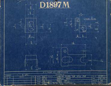
... Menhennitt 2693.15 - Russell Street Gates - Merv Brooks, John McIntyre & Roy Roberts 2693.16 - Massey Ferguson Historic Building Demolition Permit...Menhennitt 2693.15 - Russell Street Gates - Merv Brooks, John McIntyre & Roy Roberts 2693.16 - Massey Ferguson Historic Building Demolition Permit Collection of documents relating to the Sunshine Harvester Works H.V. ...2693.01 - H.V. McKay - D1197M Locking Plate Blue Print 2693.02 - H.V. McKay - FDR92 Side Delivery Chute Blue Print 2693.03 - H.V. McKay - Russell Street Gates 2693.04 - H.V. McKay - Sunshine Harvester Website Launch 2001 2693.05 - H.V. McKay Massey Harris - Bert Ustick's Retirement Function Invitation To Ed Jenkins 2693.06 - H.V. McKay Massey Hassey Massey Ferguson - Alec Galbraith 43 Years Of Service Complimentary Dinner Menu 2693.07 - Sunshine Harvester Works - Museum Of Victoria Website Information 2693.08 - Massey Ferguson Site - City Of Sunshine Stimulating Sunshine's Local Economy Council's Purchase Of Massey Ferguson Site 2693.09 - Sunshine Harvester Works - Newspaper Articles 2693.10 - Braybrook Implement Works Testimonials 2693.11 - H.V. McKay Memorial Scholarship 2693.12 - Sunshine Harvester Factory - A History Of Sunshine Harvester 2693.13 - H.V. McKay Satellite Horse Hoes Or Scufflers 2693.14 - H.V. McKay Machinery By E. E. Wegener & H. Menhennitt 2693.15 - Russell Street Gates - Merv Brooks, John McIntyre & Roy Roberts 2693.16 - Massey Ferguson Historic Building Demolition Permith.v. mckays massey ferguson, sunshine harvester works -
 Sunshine and District Historical Society Incorporated
Archive - H.V McKay Bulk Store
... Newspaper Article Messenger 8 January 1998 titled Saved by change of heart|Newspaper Article The Advocate 29 July 1998 titled Eyesore or piece of history|Newspaper Article titled Bulk Store is meaningless Shirley A Strossa|Newspaper Article Advocate 22 July 1998 titled Bulk Store dissent|Petition Sunshine Harvester factory Buildings Form|Historic Building Act 1981 Permit 12470 Massey Ferguson Complex|Letter from Melbourne's Living Museum of the West Incorporated 5 January 1995 expressing objection to Mr Ray Tonkin Historic Buildings Council|Newspaper Article Sunshine Advocate 25 January 1995 titlled It's our heritage|Letter to Historic Buildings Council Hearing of Application 14 February 1995|Notes Submission to hearing of Historic Building Council on 14th February 1995|Notice informing public in 1995|Flyer titled Save Our Bulk Store Building|Flyer titled Why was saving the HV McKay Bulk Store|Flyer titled The Bulk Store must be saved|Written submissions on behalf of the applicant 12 April 1995|Newspaper Article Independent 25 April 1995 titled Demolition Bid|Historical Buildings Council 1994 to 1995 Annual Report|Newspaper Article Advocate 26 April 1995 titled Surprise Appeal Woolworths seeks nod to demolish buildings|Submission in the matter of the Historic Building Act 1981 and Burns Bridge Australia on behalf of Fabcot to demolish two brick buildings on the former Massey Ferguson site 12 April 1995|Letter to Historic Building Council 1 May 1995 S&DHS opposes the further application by Burns Bridge Australia for a permit to demolish two Sunshine Harvester Factory Building namely the bulk store and the electrical power house|Letter from Department of Planning and Development to Fabcot Pty Ltd 18 May 1995 regarding Massey Ferguson Complex Devonshire Road Sunshine encloses permit allowing the demoltition of the substation powerhouse building|Newspaper Article Brimbank Independent 23 May 1995 titled Compromise Breatkthrough for harvester site complex|Newspaper Article The Advocate 24 May 1995 titled Harvester building must be retained|Letter to Historic Buildings Council 24 August 1995 raising concerns|Newspaper Article The Times 30 August 1995 titled Woolworths unveils $70m Sunshine plan|Newspaper Article The Advocate 4 June 1997 titled Reaping the benefits|Letter to Heritage Victoria 23 September 1997 oppose Application from Amanda Johns of Minter Ellison for a permit to demolish the building|Letter from Melbourne's Living Museum of the West Incorporated 9 October 1997 expressing concern to S&DHS|Letter to Brimbank City Council 20th October 1997 S&DHS to draw certain matters to your attention|Newspaper Article The Advocate 29 October 1997 titled Renewed bid to Demolish Eyesore|Newspaper Article Brimbank Independent 4 November 1997 titled Fomer council blamed for McKay buildings disrepair The Sunshine factory was the birthplace of the basic award wage in Australia|Newspaper Article Brimbank Messenger 11 November 1997 titled Demolition threat on historic building|Newspaper Article Brimbank Independent 11 November 1997 titled Council waits for Heritage Victoria report before decision on Bulk Store threat|Newspaper Article The Age 13 November 1997 titled Past harvest of labor struggle and victory|Newspaper Article The Advocate 19 November 1997 titled Protecting our history|Letter from Adminstrative Appeals Tribunal 25 November 1997 advising hearing date|Letter to Adminstrative Appeals Tribunal 4 December 1997 Community & S&DHS objections to the demolition|Newspaper Article The Advocate 10 December 1997 titled Cinema Chaos|Newspaper Article The Age 15 December 1997 titled Rallying to maintain a little ray of Sunshine|Newspaper Article The Advocate 17 December 1997 titled Bulk Store Victory|Newspaper Article The Advocate 17 December 1997 titled McKay store fails to rate|Letter to Heritage Victoria from Beauchamp Consulting Engineers recommended repair method for the Former Massey Ferguson Bulk Store|Newspaper Article Brimbank Independent 17 February 1998 titled Bulk Store to be saved|Collection of documents of Gwen Goedecke regarding saving the Bulk Store|Advertising Melbourne's first 20 screen megaplex Village Cinemas|Blank Application to add building to the register of Historic buildings|Typed report from Beauchamp Consulting Engineers for Recommended Repair Method for Bulk Store|Typed report from Speroulla Christodoulou to Trades Hall Council regarding developer Woolworths want to demolish the Bulk Store building including all newspaper articles|Newspaper Article Brimbank Independent 26 January 1999 Funding Rejection for bulk store plans|Typed report The Story of How the Bulk Store was saved|Notice HV McKay Electrical Power House and Bulk Store|Typed report Why was saving the HV McKay Bulk Store so important?...McKays Sunshine Harvester Works Bulk Store Newspaper Article Messenger 8 January 1998 titled Saved by change of heart|Newspaper Article The Advocate 29 July 1998 titled Eyesore or piece of history|Newspaper Article titled Bulk Store is meaningless Shirley A Strossa|Newspaper Article Advocate 22 July 1998 titled Bulk Store dissent|Petition Sunshine Harvester factory Buildings Form|Historic Building Act 1981 Permit 12470 Massey Ferguson Complex|Letter from Melbourne's Living Museum of the West Incorporated 5 January 1995 expressing objection to Mr Ray Tonkin Historic Buildings Council|Newspaper Article Sunshine Advocate 25 January 1995 titlled It's our heritage|Letter to Historic Buildings Council Hearing of Application 14 February 1995|Notes Submission to hearing of Historic Building Council on 14th February 1995|Notice informing public in 1995|Flyer titled Save Our Bulk Store Building|Flyer titled Why was saving the HV McKay Bulk Store|Flyer titled The Bulk Store must be saved|Written submissions on behalf of the applicant 12 April 1995|Newspaper Article Independent 25 April 1995 titled Demolition Bid|Historical Buildings Council 1994 to 1995 Annual Report|Newspaper Article Advocate 26 April 1995 titled Surprise Appeal Woolworths seeks nod to demolish buildings|Submission in the matter of the Historic Building Act 1981 and Burns Bridge Australia on behalf of Fabcot to demolish two brick buildings on the former Massey Ferguson site 12 April 1995|Letter to Historic Building Council 1 May 1995 S&DHS opposes the further application by Burns Bridge Australia for a permit to demolish two Sunshine Harvester Factory Building namely the bulk store and the electrical power house|Letter from Department of Planning and Development to Fabcot Pty Ltd 18 May 1995 regarding Massey Ferguson Complex Devonshire Road Sunshine encloses permit allowing the demoltition of the substation powerhouse building|Newspaper Article Brimbank Independent 23 May 1995 titled Compromise Breatkthrough for harvester site complex|Newspaper Article The Advocate 24 May 1995 titled Harvester building must be retained|Letter to Historic Buildings Council 24 August 1995 raising concerns|Newspaper Article The Times 30 August 1995 titled Woolworths unveils $70m Sunshine plan|Newspaper Article The Advocate 4 June 1997 titled Reaping the benefits|Letter to Heritage Victoria 23 September 1997 oppose Application from Amanda Johns of Minter Ellison for a permit to demolish the building|Letter from Melbourne's Living Museum of the West Incorporated 9 October 1997 expressing concern to S&DHS|Letter to Brimbank City Council 20th October 1997 S&DHS to draw certain matters to your attention|Newspaper Article The Advocate 29 October 1997 titled Renewed bid to Demolish Eyesore|Newspaper Article Brimbank Independent 4 November 1997 titled Fomer council blamed for McKay buildings disrepair The Sunshine factory was the birthplace of the basic award wage in Australia|Newspaper Article Brimbank Messenger 11 November 1997 titled Demolition threat on historic building|Newspaper Article Brimbank Independent 11 November 1997 titled Council waits for Heritage Victoria report before decision on Bulk Store threat|Newspaper Article The Age 13 November 1997 titled Past harvest of labor struggle and victory|Newspaper Article The Advocate 19 November 1997 titled Protecting our history|Letter from Adminstrative Appeals Tribunal 25 November 1997 advising hearing date|Letter to Adminstrative Appeals Tribunal 4 December 1997 Community & S&DHS objections to the demolition|Newspaper Article The Advocate 10 December 1997 titled Cinema Chaos|Newspaper Article The Age 15 December 1997 titled Rallying to maintain a little ray of Sunshine|Newspaper Article The Advocate 17 December 1997 titled Bulk Store Victory|Newspaper Article The Advocate 17 December 1997 titled McKay store fails to rate|Letter to Heritage Victoria from Beauchamp Consulting Engineers recommended repair method for the Former Massey Ferguson Bulk Store|Newspaper Article Brimbank Independent 17 February 1998 titled Bulk Store to be saved|Collection of documents of Gwen Goedecke regarding saving the Bulk Store|Advertising Melbourne's first 20 screen megaplex Village Cinemas|Blank Application to add building to the register of Historic buildings|Typed report from Beauchamp Consulting Engineers for Recommended Repair Method for Bulk Store|Typed report from Speroulla Christodoulou to Trades Hall Council regarding developer Woolworths want to demolish the Bulk Store building including all newspaper articles|Newspaper Article Brimbank Independent 26 January 1999 Funding Rejection for bulk store plans|Typed report The Story of How the Bulk Store was saved|Notice HV McKay Electrical Power House and Bulk Store|Typed report Why was saving the HV McKay Bulk Store so important? ...Newspaper Article Messenger 8 January 1998 titled Saved by change of heart|Newspaper Article The Advocate 29 July 1998 titled Eyesore or piece of history|Newspaper Article titled Bulk Store is meaningless Shirley A Strossa|Newspaper Article Advocate 22 July 1998 titled Bulk Store dissent|Petition Sunshine Harvester factory Buildings Form|Historic Building Act 1981 Permit 12470 Massey Ferguson Complex|Letter from Melbourne's Living Museum of the West Incorporated 5 January 1995 expressing objection to Mr Ray Tonkin Historic Buildings Council|Newspaper Article Sunshine Advocate 25 January 1995 titlled It's our heritage|Letter to Historic Buildings Council Hearing of Application 14 February 1995|Notes Submission to hearing of Historic Building Council on 14th February 1995|Notice informing public in 1995|Flyer titled Save Our Bulk Store Building|Flyer titled Why was saving the HV McKay Bulk Store|Flyer titled The Bulk Store must be saved|Written submissions on behalf of the applicant 12 April 1995|Newspaper Article Independent 25 April 1995 titled Demolition Bid|Historical Buildings Council 1994 to 1995 Annual Report|Newspaper Article Advocate 26 April 1995 titled Surprise Appeal Woolworths seeks nod to demolish buildings|Submission in the matter of the Historic Building Act 1981 and Burns Bridge Australia on behalf of Fabcot to demolish two brick buildings on the former Massey Ferguson site 12 April 1995|Letter to Historic Building Council 1 May 1995 S&DHS opposes the further application by Burns Bridge Australia for a permit to demolish two Sunshine Harvester Factory Building namely the bulk store and the electrical power house|Letter from Department of Planning and Development to Fabcot Pty Ltd 18 May 1995 regarding Massey Ferguson Complex Devonshire Road Sunshine encloses permit allowing the demoltition of the substation powerhouse building|Newspaper Article Brimbank Independent 23 May 1995 titled Compromise Breatkthrough for harvester site complex|Newspaper Article The Advocate 24 May 1995 titled Harvester building must be retained|Letter to Historic Buildings Council 24 August 1995 raising concerns|Newspaper Article The Times 30 August 1995 titled Woolworths unveils $70m Sunshine plan|Newspaper Article The Advocate 4 June 1997 titled Reaping the benefits|Letter to Heritage Victoria 23 September 1997 oppose Application from Amanda Johns of Minter Ellison for a permit to demolish the building|Letter from Melbourne's Living Museum of the West Incorporated 9 October 1997 expressing concern to S&DHS|Letter to Brimbank City Council 20th October 1997 S&DHS to draw certain matters to your attention|Newspaper Article The Advocate 29 October 1997 titled Renewed bid to Demolish Eyesore|Newspaper Article Brimbank Independent 4 November 1997 titled Fomer council blamed for McKay buildings disrepair The Sunshine factory was the birthplace of the basic award wage in Australia|Newspaper Article Brimbank Messenger 11 November 1997 titled Demolition threat on historic building|Newspaper Article Brimbank Independent 11 November 1997 titled Council waits for Heritage Victoria report before decision on Bulk Store threat|Newspaper Article The Age 13 November 1997 titled Past harvest of labor struggle and victory|Newspaper Article The Advocate 19 November 1997 titled Protecting our history|Letter from Adminstrative Appeals Tribunal 25 November 1997 advising hearing date|Letter to Adminstrative Appeals Tribunal 4 December 1997 Community & S&DHS objections to the demolition|Newspaper Article The Advocate 10 December 1997 titled Cinema Chaos|Newspaper Article The Age 15 December 1997 titled Rallying to maintain a little ray of Sunshine|Newspaper Article The Advocate 17 December 1997 titled Bulk Store Victory|Newspaper Article The Advocate 17 December 1997 titled McKay store fails to rate|Letter to Heritage Victoria from Beauchamp Consulting Engineers recommended repair method for the Former Massey Ferguson Bulk Store|Newspaper Article Brimbank Independent 17 February 1998 titled Bulk Store to be saved|Collection of documents of Gwen Goedecke regarding saving the Bulk Store|Advertising Melbourne's first 20 screen megaplex Village Cinemas|Blank Application to add building to the register of Historic buildings|Typed report from Beauchamp Consulting Engineers for Recommended Repair Method for Bulk Store|Typed report from Speroulla Christodoulou to Trades Hall Council regarding developer Woolworths want to demolish the Bulk Store building including all newspaper articles|Newspaper Article Brimbank Independent 26 January 1999 Funding Rejection for bulk store plans|Typed report The Story of How the Bulk Store was saved|Notice HV McKay Electrical Power House and Bulk Store|Typed report Why was saving the HV McKay Bulk Store so important?|Letter to Brimbank City Council suggestion to use the Bulk Store as a youth centre|Letter to Norman Carlton at Sunshine and District Historical Society from Brimbank Council 8 September 2003|Letter from National Trust to Historical Buildings Council dated 5 March 1987|Report for submission in support of the Proposed demolition of Registered Historic Buildings for Former Bulk Store and Former Power Station Prepared for Burns Bridge Australia on behalf of Woolworths Pty Ltd|Letter to Heritage Victoria from Frank Ford dated 23 September 1997 pointing out structural reports and Brimbank Councils position and cultural significance of the Bulk Store Building|Handwritten Notes about Bulk Store 12 December 1997|Handwritten Notes about Bulk Store 15 December 1997|Handwritten Notes about Bulk Store 25 January 1998|Handwritten Notes about Bulk Store 29 January 1998|Various correspondence of City of Sunshine Councillors touring interstate for ideas of shopping mallsh.v. mckays, sunshine harvester works, bulk store -
 Bendigo Military Museum
Photograph - Continuous Indoor Cricket World Record Attempt, Seymour, Victoria, 1986
... The event was held at the Seymour Indoor Cricket Centre, an iron-roofed building with no air-conditioning, and all players had to battle the effect of the stifling heat in addition to fatigue. One player dropped out through exhaustion, but this did not prejudice the record attempt as the rules permitted each team to lose a player who cannot return to the game nor be replaced. ...The event was held at the Seymour Indoor Cricket Centre, an iron-roofed building with no air-conditioning, and all players had to battle the effect of the stifling heat in addition to fatigue. One player dropped out through exhaustion, but this did not prejudice the record attempt as the rules permitted each team to lose a player who cannot return to the game nor be replaced. ...This is a set of 12 photographs of Army teams from the Army Survey Regiment, Bendigo and the Army School of Transport, Puckapunyal attempting a world record playing indoor cricket, at Seymour Victoria from the 31st of January to the 5th of February 1986. The following article appeared on the back page of the ARMY Newspaper on Thursday 6th of March 1986. 'INDOOR CRICKET RECORD SMASHED. ARMY TEAMS from Puckapunyal and Bendigo recently played indoor cricket for 124 hours to set a new world record. The two eight-man teams, from Army School of Transport and Army Survey Regiment, broke the 120 hour record set by Corrimal High School, NSW earlier this year. Organiser of the event, Capt Marty Alsford of AST told ARMY the teams had played 107 games, scoring 15,000 runs in their chase for the record. "The rules allowed a five-minute rest break every hour which could be accrued, so we played for 64 hours straight then had a five hour sleep. "When everybody got up and went straight back into the game with no grumbling, I knew we had the record," Capt Alsford said. The event was held at the Seymour Indoor Cricket Centre, an iron-roofed building with no air-conditioning, and all players had to battle the effect of the stifling heat in addition to fatigue. One player dropped out through exhaustion, but this did not prejudice the record attempt as the rules permitted each team to lose a player who cannot return to the game nor be replaced. The Army teams' effort are now awaiting recognition by the Guinness Book of Records. During the marathon event, the soldiers raised money for Legacy, through sponsorships and a raffle. At the time ARMY went to press, the final figure was not available.’ Army Survey Regiment Routine Orders Part 1 Issue No 16/86 Notices on Page 7 stated: ‘World Record Indoor Cricket. 1. Congratulations to the following members for their successful attempt on the Guinness Book of Records, Record for continuous playing of indoor cricket: John Whaling, Peter Ball, Brenton McDonald, Per Andersen, John Anderson, Brian Fauth, Brett McAllister and Daryl South. 2. Our team, playing a team from Army School of Transport at Seymour played continuous Indoor Cricket for 124 hours, beating the existing record by 4 hours. During that time the two teams amassed a total in excess of 16,000 runs. 3. Congratulations also to Peter Ball for picking up the Trophy for the most outstanding player during the record attempt.’This is a set of 12 photographs of Army teams from Bendigo and Puckapunyal attempting a world record playing indoor cricket, at Seymour Victoria in February 1986. The photographs were printed on photographic paper and are part of the Army Survey Regiment’s Collection. The colour photographs were scanned at 300 dpi. .1) - Photo, colour, 1986, L to R: John ‘Junior’ Whaling, Marty Alsford. Background L to R: Peter Ball, unidentified, John ‘Flash’ Anderson. .2) - Photo, colour, 1986, L to R: John ‘Junior’ Whaling, unidentified, Peter Ball. .3) to .7) - Photo, colour, 1986, unidentified participants. .8) - Photo, colour, 1986, L to R: unidentified, Peter Ball, Brett McAllister, John ‘Junior’ Whaling. .9) - Photo, colour, 1986, L to R: unidentified, John ‘Flash’ Anderson, Brian Fauth, unidentified, Peter Ball, unidentified (x2). .10) - Photo, colour, 1986, Army School of Transport (red & white uniform) - back row L to R: unidentified (x4), front row L to R: unidentified (x3), Marty Alsford. Army Survey Regiment (dark green uniform) - back row L to R: Brett McAllister, John ‘Flash’ Anderson, Brian Fauth, Per Andersen, front row L to R: John ‘Junior’ Whaling, Daryl South, Brenton McDonald, Peter Ball. .11) & .12) - Photo, colour, 1986, Army Survey Regiment (dark green uniform) - back row L to R: Peter Ball, Per Andersen, Brett McAllister, Brian Fauth, front row L to R: Brenton McDonald, John ‘Flash’ Anderson, Daryl South, John ‘Junior’ Whaling..1P to .12P –No personnel are identified. ‘Attempt at World Record for Indoor Cricket 31 Jan - 5 Feb 1986’ annotated on cover sleeve.royal australian survey corps, rasvy, army survey regiment, army svy regt, fortuna