Showing 538 items matching "bus routes"
-
 Melbourne Tram Museum
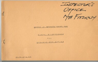
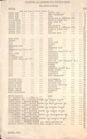
Book, Melbourne & Metropolitan Tramways Board (MMTB), "Fares and Sections for One-Man Bus Routes", 27/09/1964 12:00:00 AM
... "Fares and Sections for One-Man Bus Routes"... Bus Routes... hand side, titled "Fares and Sections for One-Man Bus Routes... Trams tramways Tickets Fares Sections Passes Bus Routes ...Book - 43 pages + brown card covers, stapled in the left hand side, titled "Fares and Sections for One-Man Bus Routes", providing fares for each section, table of contents for the various one man bus routes from Doncaster, Melbourne Services, All night services. Has a table for each bus route, giving the section location, travel conditions and fares. Printed using a purple colour Gestener ink. Dated 27/9/1964.On front cover in black Texta "Inspector's Office Nth Fitzroy".trams, tramways, tickets, fares, sections, passes, bus routes, doncaster, all night services -
 Bendigo Historical Society Inc.
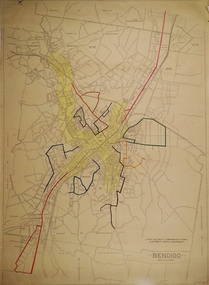
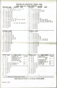
Map - BENDIGO BUS ROUTES, 1934 - 1958 ?
... BENDIGO BUS ROUTES... Bendigo Bus Routes...Map: Bendigo bus Routes, State Electricity Commission... Bus Routes Map: Bendigo bus Routes, State Electricity ...Map: Bendigo bus Routes, State Electricity Commission of Victoria, Electricity Supply Department. Printed on the bottom right hand corner F.E.B 23-12-47 , R.L.A. 5-9-58, 19-9-34, 27-11-37. 4 Mapsmap, bendigo, transport, state electricity commission, bendigo bus routes -
 Ballarat Tramway Museum
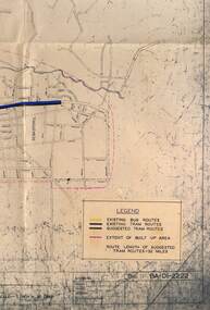
Map - Map/s, State Electricity Commission of Victoria (SECV), Ballarat bus routes, 1971
... Ballarat bus routes ... Bus Routes... Board? reviewing the option for Ballarat bus routes after... Regulation Board? reviewing the option for Ballarat bus routes after ...Set of five maps prepared by the SEC/Transport Regulation Board? reviewing the option for Ballarat bus routes after the closure of the Ballarat tramway system. Based on SEC drawing No. BA-D1-2222, drawn at 1" = 20 chains. Shows streets in Ballarat and Sebastopol areas. 1775.1 - tram lines shown in heavy blue lines, with grey and yellow (actual operating bus routes at the time?) routes marked out. A red dashed line defines the general built up area. 1775.2 - "PLAN A" - shows various routes in different colours for Davis, Sproule, Hick ex Whkes, Lyons, Braybrooks and Witkins services and existing tram lines. 1775.3 - "Plan B" 1775.4 - "Plan C" 1775.5 - "Plan D" 1175.6 - Plan as above, but showing existing bus routes, tram routes and suggested tram routes. Has a small sheet of paper that was clipped to the drawing. Not dated. Not known exactly the basis that these plans were drawn up on. Drawings to be scanned.trams, tramways, closure, bus routes, tram replacement, sec, transport regulation board, ballarat, tram routes -
 Melbourne Tram Museum
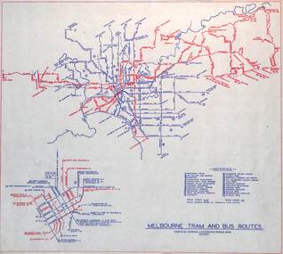
Map, Melbourne & Metropolitan Tramways Board (MMTB), "Melbourne tram and bus routes", c1961
... "Melbourne tram and bus routes"...Map showing MMTB tram and bus routes following the closure...Map showing MMTB tram and bus routes following the closure ...Map showing MMTB tram and bus routes following the closure of the Point Ormond line on 22/10/1960 and before the closure of the Footscray lines on 10/3/1962. Shows route numbers at termini and along the route and points of interest in a reference table. Yields information the MMTB services c1961.Map - printed in two colours on paper. Two copies held.tramways, map, mmtb, tram, bus, routes -
 Melbourne Tram Museum
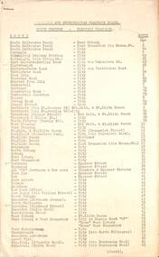
Document, Melbourne & Metropolitan Tramways Board (MMTB), "MMTB Route Numbers - Bus Routes" 1961 & 1962
... "MMTB Route Numbers - Bus Routes" 1961 & 1962...Provides a list of bus route numbers in 1961 and 1962... "MMTB Bus Routes Numbers". .1 - dated March 1961 - 1 sheet .2... Provides a list of bus route numbers in 1961 and 1962. The 1962 ...Provides a list of bus route numbers in 1961 and 1962. The 1962 sheet shows the additional routes following the take over of the bus routes in the Box Hill, Warrandyte and Ringwood areas.Yields information about bus route numbers.Set of two, Gestetner printed lists, foolscap sheets titled "MMTB Bus Routes Numbers". .1 - dated March 1961 - 1 sheet .2 - dated December 1962 - 2 sheetsItem 2 has "Obtained 2 May 1967" along top edge.tramways, trams, mmtb, route numbers, routes, buses -
 Bendigo Historical Society Inc.
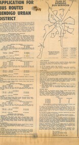
Newspaper - NEWSPAPER PUBLIC NOTICES ITEM BY TRB ADVERTISING APPLICATIONS FOR BUS ROUTES IN THE BENDIGO URBAN DISTRICT, TO REPLACE THE BENDIGO AND EAGLEHAWK DISTRICTS ADVERTISER SAT. DEC. 19 1970
... APPLICATIONS FOR BUS ROUTES IN THE BENDIGO URBAN DISTRICT, TO REPLACE... advertising applications for Bus Routes in the Bendigo Urban District... Regulation Board advertising applications for Bus Routes ...Newspaper public notices item by Transport Regulation Board advertising applications for Bus Routes in the Bendigo Urban District Bendigo, to replace the electric tramways in the City of Bendigo and Borough of Eaglehawk districts Notice placed in the Bendigo Advertiser Sat. Dec. 19 1970Bendigo Advertiser -
 Melbourne Tram Museum
Document - Timetable - MMTB bus routes 1962 and 1963, Melbourne & Metropolitan Tramways Board (MMTB)
... Timetable - MMTB bus routes 1962 and 1963... on Melbourne bus routes to passengers. Shows the extension... bus routes to passengers. Shows the extension of the Clifton ...Produced by the MMTB to provide timetable information on Melbourne bus routes to passengers. Shows the extension of the Clifton Hill to Elsternwick route to Point Ormond after the closure of tram service to Point Ormond and for services that replaced the Footscray tram lines.Shows the method of production of timetables in the early 1960s.Set of 7 bus timetables, duplicated sheets as noted below - printed on foolscap sheets. .1 - Sunshine Park - City - 15/3/1963 - single sheet .2 - Sunshine (via South and Dynon Roads) - City Bus - 20/7/1962 - single sheet .3 -Garden City - City - undated - single sheet .4 - Queens Bridge - Fisherman's Bend, - via various routes - June 1963, four sheets stapled in top left hand corner. .5 - Deer Park - City - 14/11/1962 .6 - Clifton Hill - Point Ormond - Esternwick - undated .7 - Ballarat Road - Footscray Station - Williamstown Rd - Russell St - 15/6/1962 - three sheets stapled in top left hand corner.timetables, buses, mmtb, footscray, sunshine, fisherman's bend, clifton hill, point ormond, garden city, bus replacement -
 Ballarat Tramway Museum
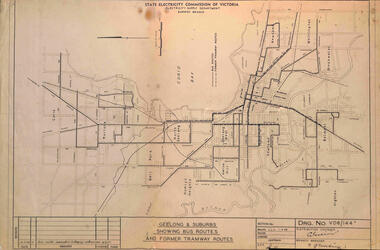
Map, State Electricity Commission of Victoria, "Geelong & Suburbs Showing Bus Routes and former Tramway Routes", 19-3-1968
... "Geelong & Suburbs Showing Bus Routes and former Tramway...Map or drawing titled "Geelong & Suburbs Showing Bus Routes...Map or drawing titled "Geelong & Suburbs Showing Bus Routes ...Map or drawing titled "Geelong & Suburbs Showing Bus Routes and former Tramway Routes", dated 19-3-1968, SEC Drawing No. VD6/144A.Demonstrates an SEC document showing a comparison between Geelong tram routes and the 1968 bus routes.Map or drawing No. VD6/144A, folded into 3.tramways, secv, geelong, buses, maps -
 Melbourne Tram Museum
Document, Melbourne & Metropolitan Tramways Board (MMTB), "MMTB Route Numbers - Tram & bus Routes" 1957, 1958 & 1965
... "MMTB Route Numbers - Tram & bus Routes" 1957, 1958 & 1965... - dated November 1957 .2 - dated 27 Sept 1965 .3 - Bus route... - dated November 1957 .2 - dated 27 Sept 1965 .3 - Bus route ...Provides a list of tram route numbers in use at the time. Yields information about tram route numbers.Set of two, Gestetner printed lists, each comprising two foolscap sheets titled "MMTB Route Numbers - Tram Routes". .1 - dated November 1957 .2 - dated 27 Sept 1965 .3 - Bus route numbers dated Dec. 1958Item 2 has "Obtained 2 May 1967" along top edge.tramways, trams, mmtb, route numbers, routes -
 Ballarat Tramway Museum
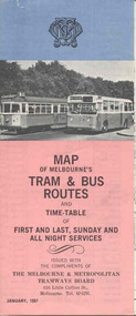
Map, Survey and Mapping for MMTB, "Map of Melbourne's Trams and Bus routes and all night services", Jan. 1967
... "Map of Melbourne's Trams and Bus routes and all night... - "Map of Melbourne's Trams and Bus routes and all night services... and Bus routes and all night services" map shows trams lines ...Fold out sheet coloured map, 12 portions or folds, - title - "Map of Melbourne's Trams and Bus routes and all night services" map shows trams lines, route numbers, terminal points, bus routes, railway lines, blow up of city area with places of interest and key. On rear details, places of interest, suburb index, index to routes, first and last services, Sunday am services, all night bus services and locations of depots and head office. 2nd copy added 11-8-2006. Images of document - scanned to A3 size and overlapping added 30/10/13 On rear "out of date" stamp and 1 "cancelled" stamp - red ink.trams, tramways, melbourne, map, tram & bus services, all night services -
 Wonga Park Community Cottage History Group
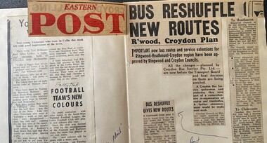
Newspaper - Newspaper cuttings Eastern Post 1964 "Bus Reshuffle New Routes - Ringwood Croydon Plan", "Bus Reshuffle New Routes - Ringwood Croydon Plan"
... Newspaper cuttings Eastern Post 1964 "Bus Reshuffle New... "Bus Reshuffle New Routes - Ringwood Croydon Plan"... with newspaper cutting/s "Bus Reshuffle New Routes - Ringwood Croydon ..."Post" 19/3/1964 - John Usher in BP Rally, "Mail" 19/3/1964 - John Usher joins family company and resigns as a teacher but continues studying Commerce part time at Melbourne University and Unknown April 1964 - Croydon Show at Hughes Park and Croydon Bus Service will run a bus there and backPage of school exercise book with newspaper cutting/s -
 Melbourne Tram Museum
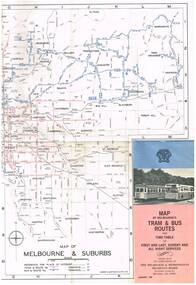
Map, Melbourne & Metropolitan Tramways Board (MMTB), "Map of Melbourne's Tram and Bus Routes" - January 1967, Jan. 1967
... "Map of Melbourne's Tram and Bus Routes" - January 1967... and Bus routes, route numbers, rail lines, and location of major... of Melbourne's Tram and Bus routes, route numbers, rail lines ...Fold out map (12 sections), coloured of Melbourne's Tram and Bus routes, route numbers, rail lines, and location of major places of interest. On rear index to routes, 1st and last services, time of Sunday am services, list of suburbs, how to get there, MMTB Offices and depots and timetable list of all-night buses services.. Dated January 1967. Two copies held. 3rd copy added 28/5/15trams, tramways, melbourne, map, tram & bus services, all night services, route numbers, mmtb -
 Melbourne Tram Museum
Ephemera - Timetable, Melbourne & Metropolitan Tramways Board (MMTB), each tram and bus routes, for weekdays, Saturdays and Sunday, May 1967 to August 1968
... each tram and bus routes, for weekdays, Saturdays and... paper for each tram and bus routes, for weekdays, Saturdays... for each route, showing both trams and buses, departure time from ...Timetable - 33 pages printed or photocopied on foolscap paper for each tram and bus routes, for weekdays, Saturdays and Sunday. Gives a timetable for each route, showing both trams and buses, departure time from terminus, and running times. Has various symbols for depot run in etc. In a style for public use. Dated May 1967 to August 1968. Full Image of route 19 sheet added 9/4/17 following a query about route 19 timetables - see image i3.trams, tramways, mmtb, timetables, buses, trams -
 Bendigo Historical Society Inc.
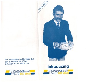
Ephemera - "Bendigo Bus" new routes, 1960 -1970s
... "Bendigo Bus" new routes....Glossy Brochure introducing "Bendigo Bus" new routes. Map... Brochure introducing "Bendigo Bus" new routes. Map of the new ...BHS CollectionGlossy Brochure introducing "Bendigo Bus" new routes. Map of the new routes and information hotline.history, bendigo, merle lummis collection, bendigo bus -
 Melbourne Tram Museum
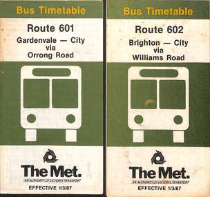
Document - Timetable - bus - Routes 601 and 602, The Met, 3/1987
... Timetable - bus - Routes 601 and 602... area. timetable The Met route 601 route 602 Buses brighton ...Timetables dated 1-3-1987 - provides information on ticketing, timing points, with a description of the route and a map. Both routes were privately run for many years prior to The Met taking them over in April 1985. See reference. 1 - Route 601 - Gardenvale - City - via Orrong Road 2 - Route 602 - Brighton - City via Williams RoadYields information about bus services in the Brighton area.Set of two, The Met timetables - both 8 fold folded sheets for routes 601 and 602.timetable, the met, route 601, route 602, buses, brighton, gardenvale -
 Melbourne Tram Museum
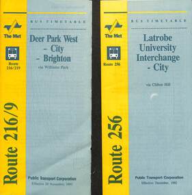
Document - Timetable - bus - Routes 216, 219 and 256, Public Transport Corporation (PTC), 1992
... Timetable - bus - Routes 216, 219 and 256... for routes 216, 219 and 256. Document Timetable - bus - Routes 216 ...Timetables - provides information on ticketing, timing points, with a description of the route and a map. 1 - Route 216 Deer Park West to Brighton and 219 - Sunshine Park to Brighton. The 216 route was extended to Melton at weekends. Dated 29-11-1993. Route 216 absorbed the former route 601 following the implementation of Swanston Walk during 1992. 2 - Route 256 - Latrobe University Interchange to City, dated Dec 1992. Yields information about bus services in the Brighton, Deer Park, and Latrobe university services.Set of two, PTC timetables - 7 or 8 fold folded sheets for routes 216, 219 and 256.timetable, buses, deer park west, brighton, latrobe university, ptc -
 Ballarat Tramway Museum
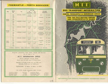
Ephemera - Timetable and map, MTT Perth, "MTT Bus Transport Information 1962" - Perth, 1962
... Bus Routes...Colour map of Perth bus routes and trolley bus routes... Parade Ballarat Ballarat goldfields MTT Perth Bus Routes ...Colour map of Perth bus routes and trolley bus routes on soft card or heavy paper. At time of the 1962 British Empire and Commonwealth Games. Title "MTT Bus Transport Information 1962" - Perth.mtt, perth, bus routes, timetables -
 Melbourne Tram Museum
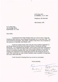
Letter, Ross Wilson, bus route numbers and opening dates, 18/10/1996 12:00:00 AM
... bus route numbers and opening dates... regarding bus route numbers and the re-opening date...Has a note "Reply 31/10/95, copies of bus route no. list... Trams tramways Routes Cable Trams Northcote Buses East Brunswick ...Letter - from Ross Wilson of Canberra to Keith Kings regarding bus route numbers and the re-opening date for the Northcote cable tramway (23/3/1901). Industrial issues with bus routes.Has a note "Reply 31/10/95, copies of bus route no. list enclosed."trams, tramways, routes, cable trams, northcote, buses, east brunswick -
 Whitehorse Historical Society Inc.
Article, Bus routes reach the end of the line, 1/07/2014 12:00:00 AM
... Bus routes reach the end of the line... Routes 201, 286 and 303 have been ignored. Bus routes reach ...Commuter calls for Transdev to reconsider changes to scrapped Routes 201, 286 and 303 have been ignored.Commuter calls for Transdev to reconsider changes to scrapped Routes 201, 286 and 303 have been ignored.Commuter calls for Transdev to reconsider changes to scrapped Routes 201, 286 and 303 have been ignored.bus services, public transport users association of victoria, public transport -
 Melbourne Tram Museum
Map, The Met, "Tram and bus Routes showing destination numbers", June 1992
... "Tram and bus Routes showing destination numbers"... and bus Routes showing destination numbers" Map The Met ...Titled "Tram Routes showing destination numbers". Map dated June 1992 and has been printed with The Met logo. Shows routes with route numbers, names of main destinations, roads, railway stations and rail lines, rivers, scales and Zones. Does not have the CBD insert. Same size as that of item 1099, a 1972 version. Type of map that was placed on the rear of the driver's doors of a W Class tramcar.Demonstrates a The Met produced map used in trramcars.Full colour map or poster printed on paper trimmed from original map and mounted on cardboard.Has some pen marks in the bottom left hand corner.trams, tramways, map, routes, the met -
 Wonga Park Community Cottage History Group
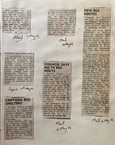
Newspaper - Newspaper cuttings 7-15 May 1964:, Mail 7/5/1964 no heading, Mail 14/5/1964 no heading, Mail 14/5/1964 no heading, Mail 14/5/1964 "Council Says No to Bus route", Mail 14/5/1964 "New Bus Routes" & Express 15/5/1964" Station Bus Shelters
... route", Mail 14/5/1964 "New Bus Routes" & Express 15/5/1964... No to Bus route", Mail 14/5/1964 "New Bus Routes" & Express 15/5 ..."Post" 19/3/1964 - John Usher in BP Rally, "Mail" 19/3/1964 - John Usher joins family company and resigns as a teacher but continues studying Commerce part time at Melbourne University and Unknown April 1964 - Croydon Show at Hughes Park and Croydon Bus Service will run a bus there and backPage of school exercise book with newspaper cutting/s -
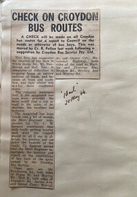 Wonga Park Community Cottage History Group
Newspaper - Newspaper cutting, Mail 28/5/1964 "Check on Croydon Bus Routes
... Mail 28/5/1964 "Check on Croydon Bus Routes... with newspaper cutting/s Mail 28/5/1964 "Check on Croydon Bus Routes ..."Post" 19/3/1964 - John Usher in BP Rally, "Mail" 19/3/1964 - John Usher joins family company and resigns as a teacher but continues studying Commerce part time at Melbourne University and Unknown April 1964 - Croydon Show at Hughes Park and Croydon Bus Service will run a bus there and backPage of school exercise book with newspaper cutting/s -
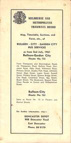 Melbourne Tram Museum
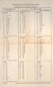
Map - Map, Timetable, Sections, and Fares, etc., of BULLEEN - CITY - GARDEN CITY BUS SERVICES
... Map of the MMTB Bulleen - City - Garden City bus routes. ...Map, timetable & fares for Bulleen to City bus route... of the MMTB Bulleen - City - Garden City bus routes. MMTB buses ...Map of the MMTB Bulleen - City - Garden City bus routes. Map, timetable & fares for Bulleen to City bus routemmtb, buses, doncaster, city -
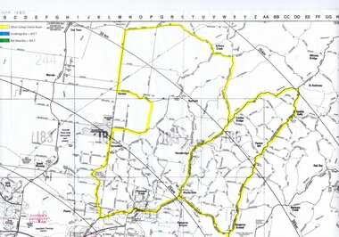 Greensborough Historical Society
Map, Greensborough c 1980s, 1980s
... bus routes...Map of Greensborough and surrounds showing bus routes... showing bus routes servicing Eltham College. greensborough - maps ...Map of Greensborough and surrounds showing bus routes servicing Eltham College.Map of Greensborough and surrounds, black print with colour markings."Bundoora Retirement Village" marked in red pen at E20greensborough - maps, eltham college, bus routes, public transport -
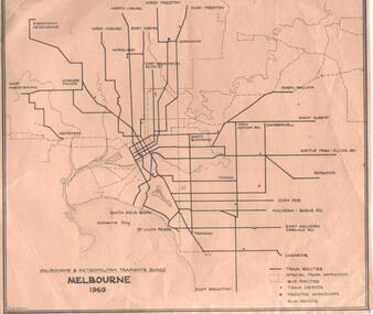 Melbourne Tram Museum
Map, Robert Green, "Melbourne 1969", 1969
... Bus Routes... routes and waterways, tram and bus depots and workshops printed... Trams tramways Map Tram Routes Bus Routes Depots Map - MMTB ...Map - MMTB "Melbourne 1969" showing MMTB tram and bus routes and waterways, tram and bus depots and workshops printed on a light brown paper, prepared by R. W. Green (Robert) Shows the names of the various suburban termini.trams, tramways, map, tram routes, bus routes, depots -
 Melbourne Tram Museum
Map, Melbourne & Metropolitan Tramways Board (MMTB), MMTB Route Maps, 1979
... bus routes...Series of colour maps for various tram and bus routes... Series of colour maps for various tram and bus routes, dated 1979 ...Series of colour maps for various tram and bus routes, dated 1979. Also contained, not scanned are letters, reports, and specifications for printing these maps for use in shelters etc. Some have the Transport Information Centre telephone printed on them. Some are finished with a plastic laminate finish on either one or both sides. Show the major cross streets, parks, schools, other tram routes, major stop numbers, and railway lines. See also item 3909 for another example of these. Trams 1 - City route guide - R9/77 - showing all route numbers and destinations that passed through the CBD. 2 - Bourke St tram routes - R4/77 - East Brunswick Blyth St and East Preston Tyler St and intermediate routes, routes 95, 96, 97, 90, 89 and 88. 3 - Malvern, East Malvern, Carnegie, and East Brighton Tram Routes (from St Kilda Junction) - R1/79 - shows routes 5, 3, 67, 66, 61, 62, and 64. 4 - Elizabeth St tram routes - R12/77 - Essendon Airport, West Maribyrnong, North Coburg lines, routes 50, 58, 60, 54, 57, 52. 49, 59, 18, 20 and 19 5 - Flinders St tram routes - R5/78 - North Balwyn, East Burwood, routes 48, 40, 41, Hartwell, 28, 74 and 75 6 - Kew - St Kilda Beach - R1/79 - Route 69. 7 - Mont - Albert City - R11/77, shows routes 43. 47. 45. 44 8 - St Kilda Rd Tram Routes R12/77 - details South Melbourne Beach, route 1 and route 2 and St Kilda Beach routes 15, 16, and 55 otherwise shows where the various routes branch off St Kilda Road 9 - Batman Ave tram routes - R9/77 - Wattle Park, North Richmond and Prahran - routes 70, 71, 78 and 79. 10 - Footscray - Moonee Ponds - R3/81 - Route 82 11 - Swanston St tram guide - R1/79 - lists all routes and route numbers that branch or cross Swanston St between Grattan St and St Kilda Junction. 12 - Toorak Camberwell and Glen Iris tram route with Camberwell Junction and Malvern Town Hall, R1/79, routes 8, 7, 6, 72, and 73 shown. 13 - West Preston - Beach tram routes - R12/77 - routes 10, 11, 9 and 12, 14 - William St tram routes - R12/77 - Route 55, 56, and 63 - South Melbourne Depot and Domain. Buses 1 - Footscray, Sunshine, Deer Park, Nth Altona & Fishermans Bend - R2/79 2 - Box Hill bus routes to Templestowe, Heidelberg & East Kew - R6/78 - notes superseded by R3/82 3 - Plan of Russell St Melbourne bus departure bays. 4 - Box Hill, Mitcham & Ringwood bus routes to East Doncaster & Warrandyte - R3/82 5 - City - Warrandyte & East Doncaster bus routes - R3/82 & R6/78 6 - Bulleen - City - Port Melbourne - Garden City Bus route - R6/78 7 - North Altona - City bus route - 11/78 8 - Clifton Hill - Elsternwick - R2/79 9 - La Trobe - Northland - West Heidelberg - City Bus Service via East Freeway - 11/79 and R3/81 10 - Box Hill, Mitcham & Ringwood Bus Routes to East Doncaster & Warrandyte - R10/84 - with the Metropolitan Transit logo.Yields information about tram and bus routes in late 1970s early 1980s.Book - brown comb binding, card and clear plastic covers containing both bound and unbound maps and documents.K C Painter on front cover in ink.tramways, mmtb, tram routes, maps, bus routes, route numbers, routes, route guide -
 Ballarat Tramway Museum
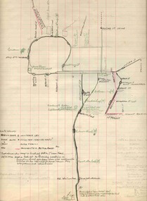
Map, H.P. James, Ballarat tramway system, 1939
... Bus Routes... line. Shows the loops, horse tram loops, depots, ESCo bus... Horse Trams Bus Routes Ballarat Hand drawn map contained within ...Hand drawn map contained within Reg. Item 2488, page 61 of the Ballarat Tramway system. Note does not show the Drummond St. North line. Shows the loops, horse tram loops, depots, ESCo bus routes, and notes on horse tram loops. Prepared by H.P. James Scan btm2515i2 and 2515i3 show the hand written notes in light pencil. Note Item Not formally Numbered.trams, tramways, map, depot, esco, horse trams, bus routes, ballarat -
 Ballarat Tramway Museum
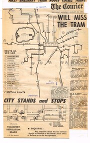
Newspaper, The Courier Ballarat, "First Ballarat Tram Route closes Today", Aug. 1971
... Bus Routes... by the Transport Regulation Board of the Ballarat bus routes, details... services in 1971 and their extent. Ballarat Buses Bus Routes Map ...Yields information about the extent of the Ballarat bus services that replaced the tram services in 1971 and their extent.Newspaper cuttings, composite, glued to a ruled or line foolscap sheet with the heading ""First Ballarat Tram Route closes Today", the Courier banner Monday 23/8/1971 (the day after the actual first closure) and a map or advertisement authorised by the Transport Regulation Board of the Ballarat bus routes, details, section points and detailed description of six routes. Would appear to have been compiled from at least two issues of The Courier, possibly by Tom Murray.ballarat, buses, bus routes, map -
 Melbourne Tram Museum
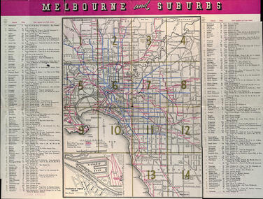
Map, Victorian Railways (VR), "Melbourne and Suburbs", 1956
... bus routes... showing rail, tram, and railway bus routes, suburbs, golf links... showing rail, tram, and railway bus routes, suburbs, golf links ...Map printed by the Victorian Railways in 1955 gives places of interest, some facts about Melbourne, and amusements, with the map showing rail, tram, and railway bus routes, suburbs, golf links, sporting grounds, and municipalities. The Bourke St tram route to East Preston is shown but not the Nicholson St East Brunswick line which opened during mid 1956. Provides a detailed list of suburbs, miles from the GPO, and how reached from where. Notes it was published in Jan. 1956 by the VR Public Relations and Betterment Board.Demonstrates a Victorian Railways printed map of MelbourneMap - 8 fold printed in colourmaps, melbourne, tramways, bus routes, railways -
 Melbourne Tram Museum
Map, Ministry of Transport, Melbourne Public Transport Map - No. 9, 1979
... Map No. 9 - Includes description of tram and bus routes... Transport Map", coloured of Melbourne's Tram and Bus routes, route... No. 9 - Includes description of tram and bus routes, private bus ...Map No. 9 - Includes description of tram and bus routes, private bus routes. Has contact details for bookings and lost property etc and how to use the map. Yields information about Melbourne public transport services in 1979Fold out map (27 sections 9 across x 3 deep), "Public Transport Map", coloured of Melbourne's Tram and Bus routes, route numbers, rail lines, detailed for the central part of Melbourne and the outer Metropolitan services.tramways, melbourne, tram services, bus services, railways, travelcard, maps