Showing 66 items matching "camberwell city council"
-
 Camberwell Historical Society
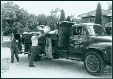
Photograph, Camberwell, Victoria, Garbage men loading rubbish into a Camberwell City Council truck, c. 1950
... Camberwell, Victoria, Garbage men loading rubbish into a Camberwell City Council truck...Print of photograph with inscription 'Camberwell Victoria, Garbage men loading rubbish into a Camberwell City Council truck c. 1950' ...Camberwell Victoria, Garbage men loading rubbish into a Camberwell City Council truck c. 1950...Camberwell Historical Society 25 Inglesby Road Camberwell melbourne Camberwell Camberwell Victoria, Garbage men loading rubbish into a Camberwell City Council truck c. 1950 Print of photograph with inscription 'Camberwell Victoria, Garbage men loading rubbish into a Camberwell City Council truck c. 1950' Camberwell, Victoria, Garbage men loading rubbish into a Camberwell City Council truck Photograph Photograph ...Print of photograph with inscription 'Camberwell Victoria, Garbage men loading rubbish into a Camberwell City Council truck c. 1950' Camberwell Victoria, Garbage men loading rubbish into a Camberwell City Council truck c. 1950camberwell -
 Surrey Hills Historical Society Collection
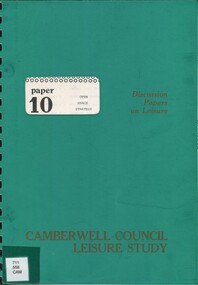
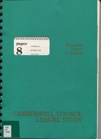
Book, Camberwell Council - Open Space Strategy: paper 10, 1982
... City of Camberwell...Camberwell City Council... of Camberwell Camberwell City Council ...Series title: Camberwell Council Leisure study: discussion papers on leisure; 10 126p.; maps; This discussion paper only present draft policies, and are published in this form to obtain the opinions of the community, councillors, field-workers and experts.126p.; maps; This discussion paper only present draft policies, and are published in this form to obtain the opinions of the community, councillors, field-workers and experts.open spaces, camberwell, victoria, recreational use -
 University of Melbourne, Burnley Campus Archives
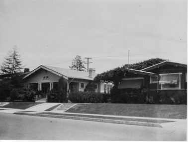
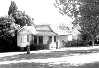
Photograph - Black and white print, Camberwell City Council, Two Suburban Houses, 1930
... Camberwell City Council...Two Suburban Houses Photograph Black and white print Camberwell City Council Stuart Tomkin ...Note by T.H. Kneen 24 June 1992, "B91.424 and 425 are paired to show effect of lowering road level and consequent adjustment to access to the houses photographed. The handwriting is Mr. Jessep's."Black and white photograph. The front of 2 suburban houses. No front fences.suburban house, a.w. jessep, landscaping -
 University of Melbourne, Burnley Campus Archives
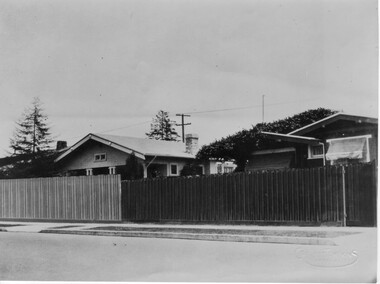
Photograph - Black and white print, Camberwell City Council, Two Suburban Houses, 1930
... Camberwell City Council...Two Suburban Houses Photograph Black and white print Camberwell City Council Stuart Tomkin ...Note by T.H. Kneen 24 June 1992, "B91.424 and 425 are paired to show effect of lowering road level and consequent adjustment to access to the houses photographed. The handwriting is Mr. Jessep's."Black and white photograph. The front of the same 2 suburban houses as B91.424. The nature strip has been lowered to the same level as the road and each has a wooden paling front fence.suburban house, a.w. jessep, landscaping -
 Canterbury History Group
Programme - First Annual Canterbury Carols
... ...Camberwell City Council...First Annual Canterbury Carols, 24/12/1945 by courtesy of the Mayor and Councillors of Camberwell City Council...Canterbury History Group 190A Canterbury Road Canterbury melbourne First Annual Canterbury Carols, 24/12/1945 by courtesy of the Mayor and Councillors of Camberwell City Council Canterbury Gardens Christmas Carols Camberwell City Council Photocopy of Program; 2 x A$ sheets; black and white type Programme First Annual Canterbury Carols ...First Annual Canterbury Carols, 24/12/1945 by courtesy of the Mayor and Councillors of Camberwell City CouncilPhotocopy of Program; 2 x A$ sheets; black and white typecanterbury gardens, christmas carols, camberwell city council -
Camberwell Historical Society
Document, Petition to investigate Camberwell Council, 1988-1993
... Correspondence and documents: Investigation into Camberwell City Council, statement by Neville Lee, faxes, minutes, newspaper clippings, and industrial dispute regarding unfair dismissal...Camberwell Historical Society 25 Inglesby Road Camberwell melbourne camberwell Council Correspondence and documents: Investigation into Camberwell City Council, statement by Neville Lee, faxes, minutes, newspaper clippings, and industrial dispute regarding unfair dismissal Petition to investigate Camberwell Council Document Document ...Correspondence and documents: Investigation into Camberwell City Council, statement by Neville Lee, faxes, minutes, newspaper clippings, and industrial dispute regarding unfair dismissalcamberwell, council -
 Eltham District Historical Society Inc
Album - Document, J.A. McDonald, Report to Works Committee: Garbage Disposal, Eltham and Montmorency Ridings, c. 1956
... ...Camberwell City Council Tip...Infrastructure shire of eltham Benchmark studies Box Hill State School Box Hill Teachers College Box Hill Tip Andrew Park Camberwell City Council Tip Eltham Lower Park Eltham Tip Health Inspector Heidelberg City Tip J.A. ...Reference report associated with photos: EDHS_05569-30-4 Box Hill Tip EDHS_05569-30-6 Camberwell Tip EDHS_05569-30-7 Camberwell Tip EDHS_05569-30-8 Camberwell TipRecord of various Shire of Eltham infrastructure works undertaken during the period of 1952-1962 involving bridge and road reconstruction projects, sometimes with Eltham Shire Council Project Reference numbers quoted. It was during this period that a number of significant improvements were made to roads and new bridges constructed within the shire that remain in place as of present day (2022). In many situations, the photos provide a tangible visible record of infrastructure that existed throughout the early days of the Shire. The album was put together by or under the direction of the Shire Engineer, J.A. McDonald.infrastructure, shire of eltham, benchmark studies, box hill state school, box hill teachers college, box hill tip, andrew park, camberwell city council tip, eltham lower park, eltham tip, health inspector, heidelberg city tip, j.a. mcdonald, montmorency park, panorama avenue, report, road construction, shire engineer, skyline theatre, tips, w.u. hughes, works committee: garbage disposal -
Camberwell Historical Society
Newspaper (Item), City of Camberwell, Camberwell City News + Progress Press, 1983-1986
... Camberwell...City of Camberwell...Council...Official journal of the Council of the City of Camberwell, February 1983 + Progress Press newspaper 2 July 1986...Camberwell Historical Society 25 Inglesby Road Camberwell melbourne Camberwell City of Camberwell Council Newspaper Progress Press Boroondara Official journal of the Council of the City of Camberwell, February 1983 + Progress Press newspaper 2 July 1986 Camberwell City News + Progress Press Newspaper Newspaper City of Camberwell Progress Press ...camberwell, city of camberwell, council, newspaper, progress press, boroondara -
Canterbury History Group
Article, 1987 Australian Heritage Award
... A report from the Camberwell City News on council's entering the Australian Heritage Award with its urban renewal project for the Maling Road Shopping Centre...Canterbury History Group 190A Canterbury Road Canterbury melbourne Canterbury Maling Road City of Boroondara Australian Heritage Award Canterbury Chamber of Commerce Maling Road Shops A report from the Camberwell City News on council's entering the Australian Heritage Award with its urban renewal project for the Maling Road Shopping Centre 1987 Australian Heritage Award Article ...A report from the Camberwell City News on council's entering the Australian Heritage Award with its urban renewal project for the Maling Road Shopping Centrecanterbury, maling road, city of boroondara, australian heritage award, canterbury chamber of commerce, maling road shops -
 Surrey Hills Historical Society Collection
Book, A History of Camberwell, 1964
... Published [Brisbane] : Jacaranda Press in association with the Camberwell City Council, 1964 From estate of Ken Hall; Cheryl Poustie was Ken's daughter. ...Published [Brisbane] : Jacaranda Press in association with the Camberwell City Council, 1964 From estate of Ken Hall; Cheryl Poustie was Ken's daughter. ...Includes description including photographs of Camberwell Junction and Burke Road, pre 1950's era. Electric transport 1916-1925, tools and waterways. Published [Brisbane] : Jacaranda Press in association with the Camberwell City Council, 1964 From estate of Ken Hall; Cheryl Poustie was Ken's daughter. Records in detail history and development of the Melbourne suburb of Camberwell. A city covering thirteen square miles. Begins with first European settlement in 1835 by John Gardiner - ending at 1960.Records in detail history and development of the Melbourne suburb of Camberwell. A city covering thirteen square miles. Begins with first European settlement in 1835 by John Gardiner - ending at 1960.Title Page: Kenneth T.Hall / 89-4418camberwell - history, (mr) john gardiner, outer circle railway, camberwell (vic) - history, broughton hall -
 Surrey Hills Historical Society Collection
Book, A history of Camberwell, 1980
... In 1964 Camberwell City Council commissioned Professor Geoffrey Blainey to first write this history. ...Surrey Hills Historical Society Collection 190A Canterbury Road Canterbury melbourne In 1964 Camberwell City Council commissioned Professor Geoffrey Blainey to first write this history. ...In 1964 Camberwell City Council commissioned Professor Geoffrey Blainey to first write this history. Since that time, many changes have taken place and therefore the Council asked Professor Blainey to bring the book up to date. Bibliography, includes index. The author presents a century of pioneering development and endeavours. He has traced the coming of the wood-cutters and the farmers, the transition from rectangular paddocks to a grid of roads and streets, the growth from shire to borough, town and city, the filling up of thirteen squares miles into residential suburbia - in successive waves of invasion, along new transport routes - including the Outer Circle Railway. Substantial chapters cover the War Years and the progress of Camberwell since the 1960s have also been included in this edition. 134p; ill;camberwell, victoria, market gardens, tolls, railways, mayors, boroondara road board, borondara shire, councillors, (mr) (prof) geoffrey blainey -
 Surrey Hills Historical Society Collection
Photograph, 3 Norfolk Road Surrey Hills - home of Mr and Mrs Albert Ernest Vine
... Box Hill Reporter (6/6/19) records that Ernest applied to Camberwell City Council for permission to subdivide land in Norfolk Road with a frontage of 85' into 2 equal lots for a dwelling to be erected on each, one for himself and the other for his mother. ...Box Hill Reporter (6/6/19) records that Ernest applied to Camberwell City Council for permission to subdivide land in Norfolk Road with a frontage of 85' into 2 equal lots for a dwelling to be erected on each, one for himself and the other for his mother. ...Albert Ernest Vine Snr, was a City of Camberwell Councillor from 1926-1934 and 1937-1944. He was also Mayor of Camberwell in 1940/41. There is a sundial in the Surrey Gardens erected in his memory. Known as Ernest, he and his wife Edith (nee Sword) lived at 3 Norfolk Road from 1920-1945. Earlier addresses are on file in Alan Holt card index. He was active in Surrey Hills Progress Association. He was the son of William James Vine (1860-1920) and Sarah Elizabeth Gunner (1859-1941). W J Vine & Co Timber Yards were located at 587-593 Canterbury Road. Elizabeth Gunner's brother was Henry Gabez Gunner (1862-1940), a builder in the Surrey Hills area. Box Hill Reporter (6/6/19) records that Ernest applied to Camberwell City Council for permission to subdivide land in Norfolk Road with a frontage of 85' into 2 equal lots for a dwelling to be erected on each, one for himself and the other for his mother. Albert Ernest & Edith Vine had the following children: Albert Ernest Jnr (b 1904), Robert (b 1908), Edgar (b 1912), Inez (b 1915) and Beth (b 1918). Both No 1 & No 3 were demolished c1970.Black and white photo of a 1920s style single-storey weatherbaord home with leadlight windows, a tiled roof and a wide veranda supported by timber columns on stucco pillars. The veranda has a simple timber balastrade and a flight of timber stairs to it. There does not appear to be front fence. A simple sloped double carport on the RHS and proud of the house is of a later date.norfolk road, californian bungalows, w j vine & co timber yards, mr william james vine, mr albert ernest vine, mrs edith vine, miss edith sword -
 Glen Eira Historical Society
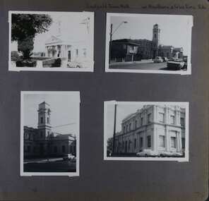
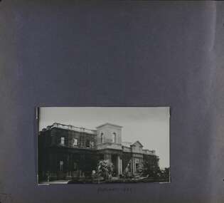
Album - Album page, Caulfield Town Hall cnr Hawthorn & Glen Eira Rds, Circa 1972
... City sustained during the Inter-war period, the work proceeding in spite of the Depression. It compares with other similar work of that time including the refurbishment of the Malvern Municipal Offices and Hall in 1927 (Hudson and Wardrop), the Melbourne Corporation Offices and Hall in 1925-28 (Stephenson and Meldrum, A. and K. Henderson) and the Camberwell Offices and Council ...This photograph is part of the Caulfield Historical Album 1972. This album was created in approximately 1972 as part of a project by the Caulfield Historical Society to assist in identifying buildings worthy of preservation. The album is related to a Survey the Caulfield Historical Society developed in collaboration with the National Trust of Australia (Victoria) and Caulfield City Council to identify historic buildings within the City of Caulfield that warranted the protection of a National Trust Classification. Principal photographer thought to be Trevor Hart, member of Caulfield Historical Society. Most photographs were taken between 1966-1972 with a small number of photographs being older and from unknown sources. All photographs are black and white except where stated, with 386 photographs over 198 pages. Caulfield Town Hall is now known as Glen Eira Town Hall.From Victorian Heritage Database: Citation for Town Hall, Corner Glen Eira and Hawthorn Roads - HO106 https://vhd.heritagecouncil.vic.gov.au/places/43613 as at (19/10/2020) The former City of Caulfield (now City of Glen Eira) Municipal Offices, located at the south-west corner of Hawthorn and Glen Eira Roads, Caulfield South, were commenced for the Borough of Caulfield in 1884 when they also included a Post and Telegraph Office and Court of Petty Sessions. They were designed by the Borough surveyor, Sydney Smith. The hall was completed in 1890 to the design of Alexander Rankin and the present hall, foyer and portico completed to the design of Goldsmith and Jenkin, architects, in 1931. The complex is historically, aesthetically and socially significant. It is historically significant {Criterion A) as the centre of Local Government services in the area since 1885 and as a centre of post and telegraph and legal services for a period. Its association with architect and Borough surveyor, Sydney W. Smith is important in that the east elevation and facade (ground floor level only)as far west as the tower (lower two stages) survive as evidence of his work, the practice which his son continued after his death in 1886, becoming highly successful. The work of Goldsmith and Jenkin is historically important in that it indirectly demonstrates the growth of the City sustained during the Inter-war period, the work proceeding in spite of the Depression. It compares with other similar work of that time including the refurbishment of the Malvern Municipal Offices and Hall in 1927 (Hudson and Wardrop), the Melbourne Corporation Offices and Hall in 1925-28 (Stephenson and Meldrum, A. and K. Henderson) and the Camberwell Offices and Council Chamber in 1924 (Leighton Irwin and Roy Stevenson), other comparable municipal projects being undertaken during the 1930s. Finally, the Goldsmith and Jenkin works are important as a project of the Depression years organised specifically to alleviate unemployment problems in the Municipality. The complex is aesthetically important (Criterion E) as a prominent and imposing Classically derived complex of its type with individually noteworthy interior spaces being the entry hall and staircase, main Hall, Foyer and Council Chamber. The Adamesque plasterwork, timber panelling and furniture, Art Nouveaux enrichment and Classically derived treatment with sparing use of Australian decorative motifs are contributory elements. Exterior .elements of note include the remains of the original design prepared by Sydney Smith and the clock tower and portico which have come to symbolise important Municipal complexes erected prior to the Second World War. The complex is socially important (Criterion G) for the value placed on it by the community which has made use of it for activities including that of Local government for well over a century.Page 74 of Photograph Album with four photographs (three portrait and one landscape) of different views of the Caulfield Town Hall.Hand written: Caulfield Town Hall cnr Hawthorn & Glen Eira Rds [top right] / 74 [bottom right] trevor hart, caulfield, glen eira, caulfield town hall, sydney smith, sydney w smith, municipal, adamesque plasterwork, adamesque, art nouveaux, portico, council chambers, alexander rankin, foyer, local government, timber panelling, tower, unemployment, clock tower, hawthorn road, glen eira road, city of glen eira, municipal offices, post and telegraph office, goldsmith and jenkin, courthouses, surveyors, architects, classical architectural style, streetscapes, gardens, cars, glen eira town hall, depression 1929-1939 -
 Glen Eira Historical Society
Album - Album page, Caulfield Town Hall cnr Hawthorn & Glen Eira Rds, Circa 1972
... City sustained during the Inter-war period, the work proceeding in spite of the Depression. It compares with other similar work of that time including the refurbishment of the Malvern Municipal Offices and Hall in 1927 (Hudson and Wardrop), the Melbourne Corporation Offices and Hall in 1925-28 (Stephenson and Meldrum, A. and K. Henderson) and the Camberwell Offices and Council ...This photograph is part of the Caulfield Historical Album 1972 but is noted as taken in 1922. This album was created in approximately 1972 as part of a project by the Caulfield Historical Society to assist in identifying buildings worthy of preservation. The album is related to a Survey the Caulfield Historical Society developed in collaboration with the National Trust of Australia (Victoria) and Caulfield City Council to identify historic buildings within the City of Caulfield that warranted the protection of a National Trust Classification. Principal photographer thought to be Trevor Hart, member of Caulfield Historical Society. Most photographs were taken between 1966-1972 with a small number of photographs being older and from unknown sources. All photographs are black and white except where stated, with 386 photographs over 198 pages. Caulfield Town Hall is now known as Glen Eira Town Hall.From Victorian Heritage Database: Citation for Town Hall, Corner Glen Eira and Hawthorn Roads - HO106 https://vhd.heritagecouncil.vic.gov.au/places/43613 as at (19/10/2020) The former City of Caulfield (now City of Glen Eira) Municipal Offices, located at the south-west corner of Hawthorn and Glen Eira Roads, Caulfield South, were commenced for the Borough of Caulfield in 1884 when they also included a Post and Telegraph Office and Court of Petty Sessions. They were designed by the Borough surveyor, Sydney Smith. The hall was completed in 1890 to the design of Alexander Rankin and the present hall, foyer and portico completed to the design of Goldsmith and Jenkin, architects, in 1931. The complex is historically, aesthetically and socially significant. It is historically significant {Criterion A) as the centre of Local Government services in the area since 1885 and as a centre of post and telegraph and legal services for a period. Its association with architect and Borough surveyor, Sydney W. Smith is important in that the east elevation and facade (ground floor level only)as far west as the tower (lower two stages) survive as evidence of his work, the practice which his son continued after his death in 1886, becoming highly successful. The work of Goldsmith and Jenkin is historically important in that it indirectly demonstrates the growth of the City sustained during the Inter-war period, the work proceeding in spite of the Depression. It compares with other similar work of that time including the refurbishment of the Malvern Municipal Offices and Hall in 1927 (Hudson and Wardrop), the Melbourne Corporation Offices and Hall in 1925-28 (Stephenson and Meldrum, A. and K. Henderson) and the Camberwell Offices and Council Chamber in 1924 (Leighton Irwin and Roy Stevenson), other comparable municipal projects being undertaken during the 1930s. Finally, the Goldsmith and Jenkin works are important as a project of the Depression years organised specifically to alleviate unemployment problems in the Municipality. The complex is aesthetically important (Criterion E) as a prominent and imposing Classically derived complex of its type with individually noteworthy interior spaces being the entry hall and staircase, main Hall, Foyer and Council Chamber. The Adamesque plasterwork, timber panelling and furniture, Art Nouveaux enrichment and Classically derived treatment with sparing use of Australian decorative motifs are contributory elements. Exterior .elements of note include the remains of the original design prepared by Sydney Smith and the clock tower and portico which have come to symbolise important Municipal complexes erected prior to the Second World War. The complex is socially important (Criterion G) for the value placed on it by the community which has made use of it for activities including that of Local government for well over a century.Page 75 of Photograph Album with one portrait photograph of the exterior of Caulfield Town Hall taken in 1922.Hand written: FEBRUARY 1922 [under photo] / 75 [bottom left] trevor hart, caulfield, glen eira, caulfield town hall, sydney smith, sydney w smith, adamesque plasterwork, art nouveaux, portico, council chambers, alexander rankin, foyer, local government, timber panelling, tower, unemployment, clock tower, hawthorn road, glen eira road, city of glen eira, municipal offices, palms, gardens, post and telegraph offices, goldsmith and jenkin, architects, city of caulfield, ivy clad walls, surveyors, depression 1929-1939, glen eira town hall -
 Glen Eira Historical Society
Article - Outer Circle Linear Park
... OUTER CIRCLE LINEAR PARK, joint submission by cities of Kew, Camberwell, Malvern and Caulfield. A bound fifteen page submission, dated 08/07/1985, by four councils urging the creation of the Outer Circle Linear Park. ...Glen Eira Historical Society 965 Glen Huntly Rd Caulfield VIC 3162 melbourne OUTER CIRCLE LINEAR PARK, joint submission by cities of Kew, Camberwell, Malvern and Caulfield. A bound fifteen page submission, dated 08/07/1985, by four councils urging the creation of the Outer Circle Linear Park. ...OUTER CIRCLE LINEAR PARK, joint submission by cities of Kew, Camberwell, Malvern and Caulfield. A bound fifteen page submission, dated 08/07/1985, by four councils urging the creation of the Outer Circle Linear Park. Includes map and photographs. OUTER CIRCLE RAILWAY: A PLAN FOR A LINEAR PARK, report of the Outer Circle Study Group. Bound booklet of one hundred and thirty five typewritten and photocopied pages about the creation of this park. The Introduction was signed by Tom Roper, Minister for Planning and Environment, and by Joan Kirner, Minister for Conservation, Forests and Lands. Undated but the Introduction states that public submissions must be received by 31/05/1988. Includes maps, sketches of proposed facilities, a history of the former Outer Circle Railway Line, and a description of notable plants and trees. A double sided, one page leaflet, published by the Murrumbeena Outer Circle Parkland Retention Group, MOCPRG, with timeline of the park and map. Undated but the last date on the timeline is 1985. Includes small sheet headed WHAT CAN YOU DO? Cutting from the CAULFIELD CONTACT titled A NEW PARK IT’S OFFICIAL, dated 26/02/1988, on official announcement of the new park. Two copies of OUTER CIRCLE LINEAR PARK, a four paged pamphlet published by Outer Circle Linear Park Implementation Committee on the new park. Includes detailed map. Letter between Felicitie E. Campbell of the Caulfield Historical Society, dated 14/09/1988 supporting the naming of a section of the Linear Park as Boyd Park. Two pages typed and a hand written copy. Also a type written letter from Jim Badger, Manager, Cultural Services, City of Caulfield, supporting the naming as Boyd Park, dated 16/08/1988. An album of thirty five colour photographs by Peter Foeden and Associates, of the official opening of the Outer Circle Linear Park by Premier John Cain, 1988. Photographs are numbered and the album includes handwritten descriptions of each photograph. Two mounted photographs of the Caulfield section of Linear Park, undated. One black and white and one colour.outer circle linear park, outer circle railway, parks, saunders r. e., briggs a. g., quinn m., rudski b., outer circle study group, roper tom, kirner joan, dunstan david, railways, trees, murrumbeena, campbell felicitie e., badger jim, peter foeden and associates, campbell adack, lang robert, gallney cr., cain john, cain nancy, boyd john, boyd arthur, boyd merric, boyd penleigh, boyd robyn, boyd james, boyd guy, ballantyne mr. -
 City of Melbourne Libraries
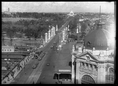
Photograph, Bull, Hugh Jones, 1897-1993, Princes Bridge Centenary pylons under construction
... city of Melbourne. It was estimated the same amount of lighting was duplicated among other local councils. The pylons were not without controversy. The Argus on 28 August 1934 in an article headed “Imported Timber in Pylons” reported that the Princes Bridge pylons are “made almost entirely of imported softwood timber”, and have therefore denied work to native hardwood timber workers and sawmillers. The same day the Melbourne Age ran a similar story, bemoaning the fact that foreign oregon had been used which may lead tourists to think Australia did not have its own exceptional native hardwoods. A Camberwell...city of Melbourne. It was estimated the same amount of lighting was duplicated among other local councils. The pylons were not without controversy. The Argus on 28 August 1934 in an article headed “Imported Timber in Pylons” reported that the Princes Bridge pylons are “made almost entirely of imported softwood timber”, and have therefore denied work to native hardwood timber workers and sawmillers. The same day the Melbourne Age ran a similar story, bemoaning the fact that foreign oregon had been used which may lead tourists to think Australia did not have its own exceptional native hardwoods. A Camberwell ...Princes Bridge Centenary pylons under construction Possibly taken from Young and Jacksons Hotel (formerly Princes Bridge Hotel) on the corner of Flinders and Swanston streets, Flinders Street Station’s clocks and main entrance dominate, along with its distinctive copper dome and decorative façade. The time on the main clock is 1.40pm, and the sign underneath, reflecting Melbourne’s upcoming Centenary reads, “We must accommodate our Centenary visitors! Citizens! Do your share by taking paying guests.” At left is the original Princes Bridge Station, today the site of Federation Square. The riverside tram terminus advertises a Café/Tobacconist/Refreshment Room selling cigars & cigarettes, fountain drinks & confectionery, and in smaller text: “Leave your boot repairs here”. Nearly everyone is dressed in dark suits, coats and hats. The footpaths are wide and there are no traffic lights. The roadway stretches towards the Shrine of Remembrance, not yet dedicated but very dominant on the skyline. Government House is clearly visible across the wide parkland that would come to be known as Kings Domain and that is an area of deep importance to the people of the Eastern Kulin. Originally, Birrarung was part of a network of swamps and lagoons linked to the course of the river. From 1896, Public Works Department engineer Carlo Catani, oversaw a new channel to straighten the river and the swamps and lagoons were filled with spoil from the channel works. From the same vantage point today, only the top of the tower of Government House would be visible. The photo captures the pylons along Princes Bridge, mid-construction and being installed to mark Melbourne’s Centenary. The pylons were not without controversy. Both The Argus and The Age bemoaned them for being “made almost entirely of imported softwood timber”, denying work to native hardwood timber workers and sawmillers, and leading visitors to think Australia did not have its own exceptional native hardwoods. The pylons were also variously described in their incomplete state, as unimaginative and resembling an oilfield. Published: The Age 5 September 1934 Featured in "Newsworthy: Melbourne in photographs 1933-1936" exhibition at East Melbourne Library, October to December 2023. Exhibition caption by project volunteer, Louise McKenzie Photographer notations on slide: "Pylons + St Kilda Rd C57" Published: Age (Melbourne, Vic. : 1854 - 1954), Wednesday 5 September 1934, page 11 Published title: DECORATIONS -- THEN AND NOW. Published caption: "Although not completed yet, some impression of the effect of the decorations on Princes-bridge may be obtained from the first picture which shows the majestic sweep of St Kilda road with the Shrine of Remembrance and Government House dominating the horizon. The area to the left of St. Kilda-road and in front of Government House is portion of the area which it is proposed to call the King's Domain, which extends to Domain-road and Anderson-street..." Description: East-facing, elevated view of Flinders Street Station and Princes Bridge, featuring partially completed pylons erected for Melbourne's Centenary celebrations. The Shrine of Remembrance and Government House can be seen in the distance. In the foreground are trams, cars and trucks, pedestrians, Batman Avenue tram terminus and refreshment rooms. Signage on Flinders Street Station encourages citizens to accommodate Centenary visitors. The Melbourne Centenary was held 1934-35 in celebration John Batman's proclamation that Melbourne "the place for a village". Centenary events included a visit by Prince Henry, Duke of Gloucester. A Centenary Cake measuring 50 feet in height and ten tons in weight was cut into 250,000 pieces and sold at 1 shilling per piece for charity. Spectacular floodlighting of city landmarks, the creation of the Pioneer Women's Memorial Garden, and the MacRobertson Air Race from London, were other notable activities. Research by project volunteer, Louise McKenzie: The photo in The Age collage of 5 September 1934 has a slightly cropped foreground. The original photo has been taken from an elevated vantage point, most probably the roof of the Nicholas Building on the corner of Flinders and Swanston streets. The right foreground is dominated by the main “clocks” entrance to Flinders Street Station, showing its distinctive copper dome and decorative façade. The time on the main clock is 1.40 pm. The main sign on the front of the Station reads, "We Must Accommodate our Centenary Visitors! Citizens! Do your share by taking paying guests. Write to The Official Centenary Accommodation Bureau, 436 Collins St. City. Tel M 4671”. Another sign at eye level at the main entrance says: “Cheap Trips on Sundays”. The sign on the end of the roof along the eastern side of the station reads, “The Babies Need Your Help! Support Broadmeadows Foundling Hospital Appeal. July and August”. Run by the Sisters of St Joseph of the Sacred Heart, St Joseph’s Foundling Hospital was a purpose built infants’ home for up to 300 babies, plus accommodation for expectant mothers, mainly single women. In the early 1930s, the department (Victorian Children’s Welfare Department) contracted St Joseph’s Foundling Hospital to care for an additional 60 infant state wards, and up to 175 non wards at any given time. In 1931 it also operated a mothercraft training school. The centre foreground shows the commencement of Princes Bridge. Beneath the left side of the bridge was the site of the original Princes Bridge Station, by this time incorporated into Flinders Street Station, and today the area is the site of Federation Square. It was linked to Flinders Street station by the railway tracks that ran underneath the northern approach to the bridge. This photo shows a tram terminus which has a Café/Tobacconist/Refreshment Room, selling cigars & cigarettes, fountain drinks & confectionary, and a sign: Leave your boot repairs here. In the foreground is a wide roadway running south/north, comprising two vehicle lanes each heading north/south, and a central section containing two sets of tram tracks. There are cars, buses and delivery vans on the roadway. The trams visible are Glen Iris (Route No. 6; tram no. 448), Toorak (Route No. 8, tram no. 333), ? (No. 7), ? (No. 1), and ? (No. 2A). The footpaths are extremely wide. There is a square newspaper/magazine stand on the eastern side footpath. And also a “Ferry” sign. There are no traffic lights, but a policeman is visible on the roadway. There are pedestrians – men, women, children, a porter with trolley, women with prams. Clothing comprises dark suits, coats and hats for nearly everyone. There are double headed “Collins Street” lights along the side of the roadway, and along the northern riverbank. The roadway in the foreground is an extension of Swanston Street, which becomes Princes Bridge, then St Kilda Road, stretching towards the Shrine of Remembrance, and diverting past it. The Shrine had not yet been officially dedicated, and looks very white and dominant on the skyline. On the LHS of St Kilda Road, Government House is clearly visible across the wide parkland to be known as Kings Domain. The Kings Domain area is important to the people of the Eastern Kulin nation, and also has historical importance for its association with the early settlement of Melbourne and the foundation of British colonial administration in Victoria. On the southern side of the Yarra River (Birrarung) an historic rowing boathouse is visible, located adjacent to the Alexandra Gardens. Originally Birrarung was part of a network of swamps and lagoons linked to the course of the river. From 1896, under the guidance of engineer Carlo Catani* a new channel to straighten the river was created and the swamps and lagoons were filled with spoil from the channel works. The gardens were then created and completed in time for a Royal visit by the Duke of York in May 1901. The gardens are named after Alexandra of Denmark, the wife of King Edward VII. Both these areas, plus the Royal Botanic Gardens Victoria, Shrine of Remembrance Reserve, Sidney Myer Music Bowl, Government House, and the Queen Victoria Gardens together form the Domain Parklands. The extent of the subsequent plantings is evident today, where from the same vantage point only the top of the tower of Government House would be visible. *Catani was born in Florence in 1852, but after arriving in Melbourne worked as a civil engineer for the Victorian Government. His last major project was the reclamation of the foreshore of St Kilda, envisaged in the style of a European resort, complete with a split level esplanade, bathing pavilions, dance halls, amusements and a French-Italian style of landscape complete with palms. The gardens at the end of Fitzroy Street, St Kilda, now bear his name. The historic boathouse visible across the Yarra is another glimpse into Melbourne’s past. “Boathouse Row” comprises 7 amateur rowing clubs, the first established in 1859 (Melbourne University Boat Club). Other Clubs were Richmond, Melbourne, Banks, Melbourne Grammar School, Yarra Yarra and Mercantile. South of the river and west of the bridge is an area today developed into the Melbourne arts precinct of Hamer Hall and the Arts Centre. But at this time it was the home of Wirths Olympia Circus, which comprised Wirths Pleasure Park (an amusement park), a 5,000 seat auditorium – Hippodrome, a roller skating rink, a glaciarium, a cinema, and the Green Mill Dance Hall. Dog shows were also held at Olympia. The Green Mill Dance Hall closed in 1950, and the remainder of the Wirth buildings on site were destroyed by fire in December 1953. The feature of the photo is the pylons erected along Princes Bridge to mark Melbourne’s Centenary in 1934. The sixteen plastered pylons were designed by Roy Prentice, the second person to qualify as an architect at The University of Melbourne’s Bachelor of Architecture degree, in 1933, aged 27. Simon Reeves in his article marking the 100th birthday of Roy Prentice on 20 June 2006 reports that the State Electricity Commission sponsored this work, and the Argus reported that “… the pylons were “illuminated from within to give the effect of soft radiance”. Australia Home Beautiful 1 Oct 1934 reports in a very detailed and comprehensive article: The 10 taller pylons, including flagpole, were 48 ft, with a base of 8 ft. Timber-framed and faced with fibrous plaster and galvanised sheet iron, each structure was securely bolted to a concrete foundation three feet in depth. Panels of glass let into the shaft of each pylon were indirectly lit by 40, 100 watt lamps, and the upper bank of internal lamps were dyed so as to flood the panels with a deep red light. The decorative painted shields and flagpoles/pennants were illuminated by three 200 watt projectors concealed in the roof of each pylon, and were part of an electric night light decoration scheme involving 28 miles of wire to supply more than 20,000 lights. An article in the Argus on 18 October 1934 provided minute detail of the lighting erected in Melbourne for the Centenary, converting it “… into a coloured fairyland by night.” The estimated cost of 10 pounds per hour the lights were on. The display included 800 standard light poles 30 feet high which were tiered with electric bulbs concealed in inverted cones, 138 specially designed “Venetian poles” draped in flags trophies and streamers. The streets included in the electric night light decoration scheme were Bourke Street from Spring to William, the entire length of Collins Street, Flinders Street from Elizabeth to Spring, Lonsdale Street from Elizabeth to Swanston, Swanston and Elizabeth Streets from Flinders to Lonsdale, and parts of Springs and Spencer Streets. Together with the Princes Bridge pylons, approximately 28 miles of wire was required to supply power to the more than 20,000 lights. And that is just in the city of Melbourne. It was estimated the same amount of lighting was duplicated among other local councils. The pylons were not without controversy. The Argus on 28 August 1934 in an article headed “Imported Timber in Pylons” reported that the Princes Bridge pylons are “made almost entirely of imported softwood timber”, and have therefore denied work to native hardwood timber workers and sawmillers. The same day the Melbourne Age ran a similar story, bemoaning the fact that foreign oregon had been used which may lead tourists to think Australia did not have its own exceptional native hardwoods. A Camberwell City Councillor described the pylons as unimaginative, and the Herald reported that skeletons of pylons for the Centenary decorations in their present form led the area to resemble an oilfield! The Yarra River and Princes Bridge have long been a focal point of Melbourne life. In the early days of European settlement in Melbourne a rope-hauled punt carried people across the Yarra River. A surge in population and increased shipping traffic created a need for a bridge. There was difficulty in agreeing on a suitable site for the bridge (options were crossing at Elizabeth, Swanston, Queen or Market Streets), but the NSW Government favoured Swanston Street and the Melbourne Town Council decided on a temporary bridge across the Yarra spanning from the foot of Swanston Street. This first bridge was a single span timber toll bridge designed by Scottish born bridge designer David Lennox, and completed in 1845. It was 120 feet long, had a roadway of 17 feet wide, and a footpath on one side of 4 feet. It was leased to the Melbourne Bridge Company in the name of Robert A Balbirnie. The tollhouse was on the north side of the river and the toll keeper, Patrick Doherty, was credited with saving nine lives during the four years he was in charge of the toll station. The second bridge was stone (completed 1850), and named Prince’s Bridge after the HRH Prince of Wales, later Edward VII. It was designed with an elliptical single arc and an exceedingly small rise in proportion to the span. However, this design created an obstacle for flood waters, and together with Melbourne’s increasing population it was quickly apparent that a new bridge was required. At its opening on 15 November 1850 coincided with the imminent declaration of Victoria as a separate colony, it provided a moment of great celebration for Melbournians and “The opening ceremony was described as the grandest processional display witnessed in the colony.” (ToMelbourne.com.au) Princes Bridge in its present form, as depicted in this photograph, was designed by Jenkins, D’Ebro and Grainger, and constructed in 1886-88 by David Munro. John Grainger (father of Australian composer Percy Grainger) did the majority of the design work for the bridge. The structure was to have three arches each 96 feet wide measured across the river, and the banks on both sides were raised to allow more space for floodwater to flow. St Kilda Road was originally many feet below the current level. The bridge is of architectural significance for its substantial size, giant half columns, extensive use of wrought and cast iron, decorative elements (cast-iron lamps) and the skilled stonemasonry in the construction of the abutments and piers. Its main design features are similar to those of Blackfriars Bridge in London (1870). The bluestones were quarried from Footscray, the Malmsbury stones were from quarries at Kyneton, and the granite from Harcourt. The cost was met by the State of Victoria, City of Melbourne, and six out of seven of its municipalities, and their coats of arms feature on the bridge. The building of the bridge reflected the boom period of Melbourne, including the Victorian gold rush 1851- late 1860s, and its contractor, David Munro, was also responsible for the construction of Queens Bridge and Sandridge Railway Bridge. The Centenary pylons are no longer in place, but today this intersection still plays a major part in Melbourne’s daily life: people still meet “under the clocks” at Flinders Street station, and the route in and out of the city along St Kilda Road is often a feature of parades such as Moomba, the Grand Final Parade, and of course the Anzac Day Parade which commences at the Princes Bridge intersection and finishes at the Shrine of Remembrance. There are many tram routes, which cross the Bridge, and it directs pedestrians towards the Arts Precinct, the various components of Domain Park, plus the Southbank restaurant and rowing precincts. Even though this is a street scene, it feels very intimate; the viewer is instantly immersed in the activity of a Melbourne afternoon, looking down St Kilda Road from a viewpoint near today’s Federation Square. References: DECORATIONS -- THEN AND NOW. (1934, September 5). The Age (Melbourne, Vic. : 1854 - 1954), p. 11. Retrieved September 21, 2023, from http://nla.gov.au/nla.news-article205880269 'Flinders Street railway station', Wikipedia, https://en.wikipedia.org/wiki/Flinders_Street_railway_station 'St Joseph’s Foundling Hospital (1901-75)', Finding Records, Department of Health and Human Services, State of Victoria, https://www.findingrecords.dhhs.vic.gov.au/collectionresultspage/St-JosephsFoundling-Hospital-Babies-Home#departmental-administration 'Alexandra Gardens', City of Melbourne, https://www.melbourne.vic.gov.au/community/parks-open-spaces/major-parks-gardens/Pages/alexandra-gardens.aspx 'Wirths Circus', Wikipedia, https://en.wikipedia.org/wiki/Wirth's_Circus 'Roy Prentice: Centenary Architect', Built Heritage Pty Ltd, Simon Reeves, https://www.builtheritage.com.au/downloads/prentice.pdf 'Princes Bridge', Heritage Council Victoria, https://vhd.heritagecouncil.vic.gov.au/places/817 PORT PHILLIP. (1846, April 1). The Sydney Morning Herald (NSW : 1842 - 1954), p. 3. Retrieved September 21, 2023, from http://nla.gov.au/nla.news-article12886251 'Edward VII', Wikipedia, https://en.wikipedia.org/wiki/Edward_VII 'Princes Bridge', ToMelbourne.com, https://tomelbourne.com.au/princes-bridge/ 'Princes Bridge', eMelbourne, https://www.emelbourne.net.au/biogs/EM01189b.htm 'Princes Bridge', Australia for everyone, http://australiaforeveryone.com.au/files/melbourne/princes-bridge.html 'Victorian gold rush', Wikipedia, https://en.wikipedia.org/wiki/Victorian_gold_rush IMPORTED TIMBER IN PYLONS (1934, August 28). The Argus (Melbourne, Vic. : 1848 - 1957), p. 9. Retrieved September 21, 2023, from http://nla.gov.au/nla.news-article10952507 Princes-Bridge Pylons. (1934, August 28). The Age (Melbourne, Vic. : 1854 - 1954), p. 7. Retrieved September 21, 2023, from http://nla.gov.au/nla.news-article205532235 Pylons Appear Near Princes Bridge (1934, August 18). The Herald (Melbourne, Vic. : 1861 - 1954), p. 1. Retrieved September 21, 2023, from http://nla.gov.au/nla.news-article243104375 PRINCES-BRIDGE PYLONS. (1934, September 20). The Age (Melbourne, Vic. : 1854 - 1954), p. 10. Retrieved September 21, 2023, from http://nla.gov.au/nla.news-article205873535 28 Miles of Wire (1934, October 18). The Argus (Melbourne, Vic. : 1848 - 1957), p. 1 (The Junior Argus). Retrieved September 21, 2023, from http://nla.gov.au/nla.news-article10977836 'Historical references for Boathouse Row, Melbourne', http://boathouserowmelbourne.com.au/history/ 'ITALIAN DELEGATION TO HONOUR CARLO CATANI, DESIGNER OF THE ST KILDA FORESHORE, St Kilda Historical Society, 2001, https://web.archive.org/web/20070928061938/http://www.skhs.org.au/~SKHSarticles/articles/Carlo_Catani.html# HISTORY IN LIGHTS (1934, July 12). The Herald (Melbourne, Vic. : 1861 - 1954), p. 16. Retrieved September 21, 2023, from http://nla.gov.au/nla.news-article243172436 'Dressing Melbourne for the Duke', The Australian home beautiful: a journal for the home builder. Vol 12 No. 10 (1 October 1934), page 21, 58. Retrieved September 14, 2023, from http://nla.gov.au/nla.obj-2950922209Photographer notations on slide: "Pylons + St Kilda Rd C57".centenaries, bridges, lighting, flinders street railway station -
 Chiltern Athenaeum Trust
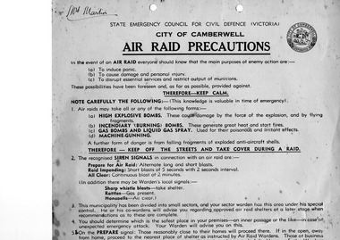
Brochure for WW2 - Air Raid Precautions "City Of Camberwell", Air Raid Precautions
... State Emergency Council for Civil Defence (Victoria) City of Camberwell Air Raid Precautions Sector Warden Mr Ashcroft Glen Iris Mr Lyte Glen Iris Nearest Wardens Post F W Smith phone U1526 Sector No. 114 Area Warden Councillor E W Raven WM1510 ...State Emergency Council for Civil Defence (Victoria) City of Camberwell Air Raid Precautions Sector Warden Mr Ashcroft Glen Iris Mr Lyte Glen Iris Nearest Wardens Post F W Smith phone U1526 Sector No. 114 Area Warden Councillor E W Raven WM1510 light card Air Raid Precautions Brochure for WW2 - Air Raid Precautions "City Of Camberwell" ...WW2light cardMrs Martin. State Emergency Council for Civil Defence (Victoria) City of Camberwell Air Raid Precautions Sector Warden Mr Ashcroft Glen Iris Mr Lyte Glen Iris Nearest Wardens Post F W Smith phone U1526 Sector No. 114 Area Warden Councillor E W Raven WM1510 -
 Surrey Hills Historical Society Collection
Book, City of Camberwell Community Information Services: Paper 8, 1982
... City of Camberwell...Camberwell (Vic) Council Research and Policy Unit...City of Camberwell, and suggests a broad framework and strategy for the development of information services. information services community groups city of camberwell 47p;i lll. This paper brings together materials on community information needs and services in the City of Camberwell, and suggests a broad framework and strategy for the development of information services. City of Camberwell Community Information Services: Paper 8 Book City of Camberwell Camberwell (Vic) Council ...47p;i lll. This paper brings together materials on community information needs and services in the City of Camberwell, and suggests a broad framework and strategy for the development of information services.47p;i lll. This paper brings together materials on community information needs and services in the City of Camberwell, and suggests a broad framework and strategy for the development of information services.information services, community groups, city of camberwell -
 Surrey Hills Historical Society Collection
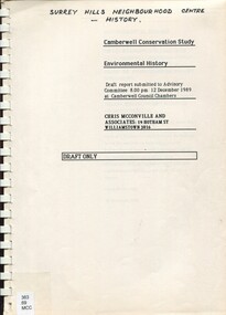
Report, Camberwell conservation study: environmental history 1989 : Draft only, 10/12/1989
... Camberwell Conservation Study: environmental history. Draft report submitted to Advisory Committee, 12 December 1989 at Camberwell Council Chambers An environmental history draft report prepared for City of Camberwell as part of the City of Camberwell Conservation Study. ...Camberwell Conservation Study: environmental history. Draft report submitted to Advisory Committee, 12 December 1989 at Camberwell Council Chambers An environmental history draft report prepared for City of Camberwell as part of the City of Camberwell Conservation Study. ...Full title on cover: Camberwell Conservation Study: environmental history. Draft report submitted to Advisory Committee, 12 December 1989 at Camberwell Council Chambers An environmental history draft report prepared for City of Camberwell as part of the City of Camberwell Conservation Study. Presented in 2 volumes. Charts the development of the suburb of Camberwell. Beginning late 1880s.An environmental history draft report prepared for City of Camberwell as part of the City of Camberwell Conservation Study. Presented in 2 volumes. Charts the development of the suburb of Camberwell. Beginning late 1880s.camberwell, land places and structures, buildings - conservation and restoration, buildings, structures and establishments, social history, public housing, camberwell estate, st john's wood (wanganella) -
 Surrey Hills Historical Society Collection
Photograph, Baby Health Centre in the Surrey Gardens, 1982, 1982
... Council for community use. The cairn commemorates the work of Cr Albert Ernest Vine who was a Camberwell Councillor from 1926-1934 and 1937-1944; he was also Mayor on 1940-41. There is a photo of him in Mayoral robes in the City...Council for community use. The cairn commemorates the work of Cr Albert Ernest Vine who was a Camberwell Councillor from 1926-1934 and 1937-1944; he was also Mayor on 1940-41. There is a photo of him in Mayoral robes in the City ...The Baby Health Centre opened in the Surrey Gardens in 1930 on the site previously occupied by the screen for outdoor pictures. Previously during the 1920s it had operated in the room underneath the rotunda in the Surrey Gardens. The room was also shared by other groups including the Surrey Hills Progress Association (SHPA). The SHPA raised 200 pounds to provide the materials for the building, which was built by voluntary labour under the leadership of Ralph Hayes, a local builder. The foundation stone was laid by Mrs A Latham, Mayoress of Camberwell on 31 March 1930. There is a bottle containing the names of the committee members sealed in the pillar behind the memorial stone. The centre was managed by a committee until 1975. Maternal health nurses associated with the centre included Sister D Thompson, Sister Newnham, Sister Kelsell, Sister Barker, Sister Sharp and Sister Bolton. Ref: Mrs D Lancashire - a long-serving member of the committee. The site of the Surrey Hills Maternal and Child Health Centre was moved to 18 Verdun Street, adjacent to the pre-school, in accord with Council policy to co-locate services and from a concern regarding solo staff working in relatively isolated locations. The building was included in the heritage overlay protecting the gardens and was refurbished by Council for community use. The cairn commemorates the work of Cr Albert Ernest Vine who was a Camberwell Councillor from 1926-1934 and 1937-1944; he was also Mayor on 1940-41. There is a photo of him in Mayoral robes in the City of Boroondara Library Service collection.Black and white photo of a timber building with a tiled roof and a brick veranda supported by brick and concrete pillars. In front of the baby health centre is a small cairn.surrey gardens, baby health centres, monuments and memorials, surrey hills progress association, cr albert ernest vine, sister d thompson, sister d. newnham, sister kelsell, sister barker, sister sharp and sister bolton, mrs a latham, ralph hayes, mrs d lancashire -
 Surrey Hills Historical Society Collection
Photograph, Grovedale Road Quarry in the 1920s - looking south, c1920
... Camberwell Council by this time. An attached newspaper clipping documents prices realised for a cross-section of blocks. The MMBW map of 1925, also on the SLV website, shows the outline of the clayhole / quarry. The quarry was filled in after several drownings or near drownings and the land is now occupied by a park and playground, known as Grovedale Road Park, maintained by the City of Boroondara. ...Camberwell Council by this time. An attached newspaper clipping documents prices realised for a cross-section of blocks. The MMBW map of 1925, also on the SLV website, shows the outline of the clayhole / quarry. The quarry was filled in after several drownings or near drownings and the land is now occupied by a park and playground, known as Grovedale Road Park, maintained by the City of Boroondara. ...The quarry was part of John Butler Maling's property. He was one of the original settlers of the area and farmed the area between Weybridge Street and Whitehorse Road. Clay was quarried from part of this area and used to make the bricks used in the construction of his home, known as 'Ancyra'. This is still extant at the corner of Weybridge and James Streets. Maling grazed cows and used the quarry as a water source. He was the uncle of John Butler Maling, Mayor of Camberwell. He was married to Kate Conlon in 1882. They had 3 children: Silas Young, Alick and Zillah. Maling was born in c1829 in Shepreth, Cambridgeshire; he died in Surrey Hills on 9 October 1912 and is buried in Box Hill Cemetery - CE-*-0586. Mrs Kate Maling (born c1859 in Co Meath, Ireland) died at the property on 8 March 1921. She is buried in Brighton General Cemetery. Probate was valued at over 10,000 pounds and included other properties in Sandringham, Hawthorn and Macedon. At the time of her death the Surrey Hills property was described as being 23 acres with 2 brick houses, 1 cow, 2 heifers and 40 fowls or chickens. The property was subdivided after her death. The property was subdivided into 110 house blocks in c1923 - see Maling's Estate subdivision flyer on the State Library of Victoria's website. This shows that the Grovedale Park site had been acquired by Camberwell Council by this time. An attached newspaper clipping documents prices realised for a cross-section of blocks. The MMBW map of 1925, also on the SLV website, shows the outline of the clayhole / quarry. The quarry was filled in after several drownings or near drownings and the land is now occupied by a park and playground, known as Grovedale Road Park, maintained by the City of Boroondara. Beckett Park is sited on horizon to the left beyond the trees. This documents the landscape prior to close settlement and is material to early building and farming in the Surrey Hills area.Black and white photo of the quarry between Grovedale Road and James Street taken in the 1920s and looking south. In the foreground is an area of water with reeds in the LH corner. Beyond on the high banks there are single storey houses in the background and (?) some light poles. An object that looks like a tank on posts is in a cutting on the far bank.quarries, grovedale road, james street, clay quarries, farming, kate conlon, kate maling, john butler maling, ancyra -
 Surrey Hills Historical Society Collection
Photograph, 'Hillsboro' or "Hillsborough' - 6a Thistle Street, Surrey Hills, pre-1890
... Camberwell Gun Club from around 1890 – 91. In 1893 he relocated to Ferntree Gully, where he contested for the municipality’s North Riding council seat. Multiple references can be found on Trove. Note that the gentleman in this photo does bear a resemblance to Thomas Sweetman, President of Boroondara Shire in 1888-1889 found in the City of Boroondara Library Service mayoral portrait collection. ...Camberwell Gun Club from around 1890 – 91. In 1893 he relocated to Ferntree Gully, where he contested for the municipality’s North Riding council seat. Multiple references can be found on Trove. Note that the gentleman in this photo does bear a resemblance to Thomas Sweetman, President of Boroondara Shire in 1888-1889 found in the City of Boroondara Library Service mayoral portrait collection. ...The photo was found behind a mantelpiece in the house at 6A Thistle Street while it was being renovated. It is thought to be of the first owner, Mrs Rachel Sweetnam (nee Lewis) and her husband, Thomas Edward Sweetnam. They were married on 24 September 1884 at St John's Church, Camberwell. REF: THE ARGUS 4 Oct 1884 Thomas second eldest surviving son of Matthew Sweetnam married to Rachel (Ray) third eldest daughter of Captain T.D. Lewis, Culm Haven, Camberwell. Thomas was active in land sales and variously described as a land agent, real estate agent and auctioneer. The property - Hillsboro or Hillsborough - was originally a house on a farm of 10 acres owned by her. It became 6A Thistle Street. According to the Alan Holt property register Rachel Sweetnam owned the property prior to 1890 and a family tree on Ancestry.com has that it was owned by her in c1886. It is likely that it was an investment rather than a family residence. Thomas Sweetnam was President of the Boroondara Shire 1888/89 and a councillor from 1886-1891. During his time as Shire councillor in 1887 he was charged with assaulting Charles A. Chandler, a window blind manufacturer, in response to an ‘insulting note’ left at Sweetnam’s house. Sweetnam was fined two guineas and 31 shillings. Sweetnam was also President of the Camberwell Gun Club from around 1890 – 91. In 1893 he relocated to Ferntree Gully, where he contested for the municipality’s North Riding council seat. Multiple references can be found on Trove. Note that the gentleman in this photo does bear a resemblance to Thomas Sweetman, President of Boroondara Shire in 1888-1889 found in the City of Boroondara Library Service mayoral portrait collection. No known photo of Rachel Sweetnam. Other property owners or residents are: 1890 Selina Gaylor 1900 Stephen Pullen 1910 William Murray (draftsman) 1920 George C Hughes 1930 Arthur Leslie Austin (tram driver) 1980 Mrs Lillian Evelyn Austin Sold in 1983 for $87,000. The house is still extant (January 2025). Note that we also have material / photos regarding George Hughes and family.This photo is one of the earliest photos of residences of Surrey Hills.Black and white photo of a woman and man in a buggy behind which is a simple house with a verandah at one end, surrounded by eucalypt trees.hillsboro, house names, thistle street, horse-drawn vehicle, clothing and dress, hillsborough, rachel sweetnam, rachel lewis, thomas sweetnam, selina gaylor, stephen pullen, william murray, george hughes, arthur austin, lillian austin -
Surrey Hills Historical Society Collection
Work on paper - Vertical file, City of Camberwell
... Camberwell City News, October, 1984. (8 pages). 7. City of Camberwell 1984/5 budget. (8 pages). 8. ‘’Recycling – It’s up to you’’ (source uncertain, like Council publication undated). (1 page). 9. ‘’Big bins arrive’’, Free Press, 1.2.1984. (1 page). 10. ...Camberwell City News, October, 1984. (8 pages). 7. City of Camberwell 1984/5 budget. (8 pages). 8. ‘’Recycling – It’s up to you’’ (source uncertain, like Council publication undated). (1 page). 9. ‘’Big bins arrive’’, Free Press, 1.2.1984. (1 page). 10. ...A vertical file of clippings and general information relating to the City of Camberwell including: 1. Election notice, The Argus, 28.8.1937 (1 page). 2. “City news”: Council announces conservation position. Undated. (8 pages). 3. “Council to introduce new waste collection”. Undated Council publication. (4 pages). 4. Camberwell newsletter (incomplete, undated). (4 pages). 5. Camberwell City News, December 1983. (8 pages). 6. Camberwell City News, October, 1984. (8 pages). 7. City of Camberwell 1984/5 budget. (8 pages). 8. ‘’Recycling – It’s up to you’’ (source uncertain, like Council publication undated). (1 page). 9. ‘’Big bins arrive’’, Free Press, 1.2.1984. (1 page). 10. New bins photo and article – no heading; Free Press, 11 April 1884 with note re role of Cr Jim Rumpf. 11. Booklet: Camberwell Your City 82, 31 pages includes business ads as well as municipal information; published 1982. 12. Article re Richard Pearse, newly elected councillor re his philosophy; SHNN No 9, April / May 1984. 13. Article re Mary Drost, newly elected councillor re her philosophy; SHNN No 4, June / July, 1983. 14. Article re Irene Wegner, newly elected councillor re his philosophy; SHNN No 18, October / November 1985. 15. Article asking questions of ward candidates Patrick Trost and Alex Briggs, SHNN No 11, August / September 1984. 16. Articles re new councillors Jennie Carey and Sally Brentnall, SHNN No 39, April /May 1989. 17. Articles re views of ward candidates Wendy Nettle, David McCloskey and Alan Black, SHNN No 23, August / September 1986. 18. Article re CEO Brian Jones, SHNN No 39, April / may 1989. 19. Article questioning Council's conservation strategy in the light of proposed Red rooster development and forthcoming sale of then post office in Canterbury Road, SHHN No 64, June / July 1993. 20. Article urging voting at August 1992 local government elections; candidates mentioned: Bryan Steele, Joe Stanley, Ted Dugdale, Ilias Gouletas, Dennis Whelan, Phillip Barresi, SHNN No 59, August / September 1992. 21. Article re Phillip Barresi and Ilias Gouletsas - with photos, SHNN No 59, August / September 1992. 22. Article re Dennis Whelan and Ted Dugdale - with photos, SHNN No 59, August / September 1992. 23. Exhibition pamphlet: 'Camberwell - As we were' produced for Victoria's 150th anniversary, 3-21 June 1985. (REF: SH2023/1/2) 24. Pamphlet re Centenary of proclamation of Boroondara Shire, 17 November 1871; includes photos. (REF: SH2023/1/5) 25. Letter from John Paech to Miss V White of Barton Street re opposition to proposed transfer of part of Surrey Hills from City of Camberwell to City of Box Hill, dated 25 July 1986. NB/ Correspondant is Miss Val White. 26. City of Camberwell By-Law No 214 - Incinerator, BBQ & Open Air Burning By-Law, dated 20 April 1988. 27. City of Camberwell By-Law No 207 - Prevention & extinguishing fires, suppressing nuisances, and regulating times incinerators may be used; dated 16 July 1984. city of camberwell, cr jim rumpf, waste collection, recycling, local government -
 Kew Historical Society Inc
Plan - Subdivision Plan, Myrtle Park Estate, City of Camberwell, 1916
... Camberwell Council. The Park adjoined the southeast corner of the new subdivision. The Estate included 74 regular allotments characterised by narrow frontages and long blocks. Confusion may have greeted prospective purchasers as the Estate was advertised in the daily newspapers as being in East Kew, rather than in Camberwell, where it was at that stage located. Myrtle Park Estate, City ...The Kew Historical Society collection includes almost 100 subdivision plans pertaining to suburbs of the City of Melbourne. Most of these are of Kew, Kew East or Studley Park, although a smaller number are plans of Camberwell, Deepdene, Balwyn and Hawthorn. It is believed that the majority of the plans were gifted to the Society by persons connected with the real estate firm - J. R. Mathers and McMillan, 136 Cotham Road, Kew. The Plans in the collection are rarely in pristine form, being working plans on which the agent would write notes and record lots sold and the prices of these. The subdivision plans are historically significant examples of the growth of urban Melbourne from the beginning of the 20th Century up until the 1980s. A number of the plans are double-sided and often include a photograph on the reverse. A number of the latter are by noted photographers such as J.E. Barnes.The ‘Myrtle Park Estate’ was a subdivision bounded by Victoria Road (now Lansdowne Street), Buchanan Avenue and Dight Avenue. Other streets that were created by the subdivision included Eurolie Street, Boorahman Street and Moody Street (now Sylvan Street). The Estate took its name from Myrtle Park (later changed to Macleay Park), which had been created in 1923 by Camberwell Council. The Park adjoined the southeast corner of the new subdivision. The Estate included 74 regular allotments characterised by narrow frontages and long blocks. Confusion may have greeted prospective purchasers as the Estate was advertised in the daily newspapers as being in East Kew, rather than in Camberwell, where it was at that stage located.subdivision plans - balwyn, myrtle park estate - camberwell [surrey hills] -
Kew Historical Society Inc
Archive (series) - Subject File, Kew, City of - Amalgamation, 1994, 1994
... Cities of Hawthorn, Kew and Camberwell. This archive file contains primary sources and publications relating to the amalgamation. The earliest item in the file is a newspaper article/clipping from the Eastern Standard (1986) recording a request from Hawthorn Council to Kew Council to consider amalgamating. ...Cities of Hawthorn, Kew and Camberwell. This archive file contains primary sources and publications relating to the amalgamation. The earliest item in the file is a newspaper article/clipping from the Eastern Standard (1986) recording a request from Hawthorn Council to Kew Council to consider amalgamating. ...Various partiesReferenceKHS OrderThe City of Kew was amalgamated into the City of Boroondara in 1994. The new city comprised the former Cities of Hawthorn, Kew and Camberwell. This archive file contains primary sources and publications relating to the amalgamation. The earliest item in the file is a newspaper article/clipping from the Eastern Standard (1986) recording a request from Hawthorn Council to Kew Council to consider amalgamating. The file also includes other newspaper articles/cuttings (some undated) reporting on opposition to the amalgamation. An interesting item in the file is a photocopy of a coloured digital photograph of the members of the last Kew Council. [The original still has to be discovered]. The file also contains a commemorative edition of Kewriosity [magazine] (1994), which lists all the chairmen and mayors of Kew (1861-1994) and three copies of the City of Kew Final Commemorative Council Meetingb14 June 1994. kew - history, local government - amalgamations - kew (vic) - boroondara (vic)kew - history, local government - amalgamations - kew (vic) - boroondara (vic) -
 Kew Historical Society Inc
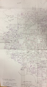
Plan, Gwen McWilliam, Annotated Plan of City of Boroondara, c.1995
... City. She was awarded the medal of the Order of Australia in 2001 ‘for service to the community of Hawthorn and district, particularly through the research, documentation and publication of its history.’ subdivisions - hawthorn, subdivisions - kew, subdivisions - camberwell, subdivisions - balwyn, subdivisions - surrey hills, subdivisions - canterbury, gwen mcwilliam Council markings in pink Digitally annotated part plan of the City of Boroondara, created by Council (Library?) ...Gwen Barton McWilliam (nee: Nelson), OAM, BA (1933- ). Gwen McWilliam is well known as an authority on the history of Boroondara and the author of a large number of books and pamphlets about the City. She was awarded the medal of the Order of Australia in 2001 ‘for service to the community of Hawthorn and district, particularly through the research, documentation and publication of its history.’ Digitally annotated part plan of the City of Boroondara, created by Council (Library?) staff, based on annotated plans provided by the historian Gwen McWilliam, identifying significant landholdings, subdivisions and key dates. On the plan Gwen McWilliam noted that the attempt to copy her annotations had resulted in incorrect data being included, so the plans were never published. For plans including her original 1993 annotations, see 2017.0143 and 2017.0144.Council markings in pinksubdivisions - hawthorn, subdivisions - kew, subdivisions - camberwell, subdivisions - balwyn, subdivisions - surrey hills, subdivisions - canterbury, gwen mcwilliam -
 Kew Historical Society Inc
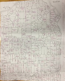
Plan, Gwen McWilliam, Annotated Plan of City of Boroondara, c.1995
... City. She was awarded the medal of the Order of Australia in 2001 ‘for service to the community of Hawthorn and district, particularly through the research, documentation and publication of its history.’ subdivisions - hawthorn, subdivisions - kew, subdivisions - camberwell, subdivisions - balwyn, subdivisions - surrey hills, subdivisions - canterbury, gwen mcwilliam Council additions in pink Digitally annotated part plan of the City of Boroondara, created by Council (Library?) ...Gwen Barton McWilliam (nee: Nelson), OAM, BA (1933- ). Gwen McWilliam is well known as an authority on the history of Boroondara and the author of a large number of books and pamphlets about the City. She was awarded the medal of the Order of Australia in 2001 ‘for service to the community of Hawthorn and district, particularly through the research, documentation and publication of its history.’ Digitally annotated part plan of the City of Boroondara, created by Council (Library?) staff, based on annotated plans provided by the historian Gwen McWilliam, identifying significant landholdings, subdivisions and key dates. On the plan Gwen McWilliam noted that the attempt to copy her annotations had resulted in incorrect data being included, so the plans were never published. For plans including her original 1993 annotations, see 2017.0143 and 2017.0144.Council additions in pinksubdivisions - hawthorn, subdivisions - kew, subdivisions - camberwell, subdivisions - balwyn, subdivisions - surrey hills, subdivisions - canterbury, gwen mcwilliam -
 Kew Historical Society Inc
Plan, Gwen McWilliam, Annotated Plan of City of Boroondara, c.1995
... City. She was awarded the medal of the Order of Australia in 2001 ‘for service to the community of Hawthorn and district, particularly through the research, documentation and publication of its history.’ subdivisions - hawthorn, subdivisions - kew, subdivisions - camberwell, subdivisions - balwyn, subdivisions - surrey hills, subdivisions - canterbury, gwen mcwilliam Additions in pink by City of Boroondara Digitally annotated part plan of the City of Boroondara, created by Council (Library?) ...Gwen Barton McWilliam (nee: Nelson), OAM, BA (1933- ). Gwen McWilliam is well known as an authority on the history of Boroondara and the author of a large number of books and pamphlets about the City. She was awarded the medal of the Order of Australia in 2001 ‘for service to the community of Hawthorn and district, particularly through the research, documentation and publication of its history.’ Digitally annotated part plan of the City of Boroondara, created by Council (Library?) staff, based on annotated plans provided by the historian Gwen McWilliam, identifying significant landholdings, subdivisions and key dates. On the plan Gwen McWilliam noted that the attempt to copy her annotations had resulted in incorrect data being included, so the plans were never published. For plans including her original 1993 annotations, see 2017.0143 and 2017.0144.Additions in pink by City of Boroondarasubdivisions - hawthorn, subdivisions - kew, subdivisions - camberwell, subdivisions - balwyn, subdivisions - surrey hills, subdivisions - canterbury, gwen mcwilliam -
Kew Historical Society Inc
Archive (Sub-series) - Subject File, Boroondara Bulletin, 1994
... The Bulletin was first issued by the City Commissioners following the forced amalgamation of the suburbs of Kew, Camberwell, Hawthorn etc. into the new City in 1994. The early Bulletins were like local newspapers and reported on community activities as well as Council policy. ...The Bulletin was first issued by the City Commissioners following the forced amalgamation of the suburbs of Kew, Camberwell, Hawthorn etc. into the new City in 1994. The early Bulletins were like local newspapers and reported on community activities as well as Council policy. ...City of BoroondaraReference, Research, InformationProvenance OrderSubject file containing various copies of the City of Boroondara’s ‘Boroondara Bulletin’ including Volumes 1/1, 1/4 (1994), 2/2 (1995), 4 (1997) and Nov 2010. The file also includes some other, later Ward updates. The Bulletin was first issued by the City Commissioners following the forced amalgamation of the suburbs of Kew, Camberwell, Hawthorn etc. into the new City in 1994. The early Bulletins were like local newspapers and reported on community activities as well as Council policy. Additional copies of the Boroondara Bulletin are stored in the Society’s Library.city of boroondara - boroondara bulletin, city of boroondara - publicationscity of boroondara - boroondara bulletin, city of boroondara - publications -
Kew Historical Society Inc
Archive (Sub-series) - Subject File, Boroondara Historical Societies Association (BHSA), 1994
... Typically files will contain primary and secondary sources. boroondara historical societies association historical societies - city of boroondara Reference file containing Correspondence, documents (minutes, agendas, financial statements etc.,) relating to the Boroondara Historical Societies Association. The historical societies of Kew, Camberwell, Hawthorn, Canterbury and Surrey Hills agreed, following amalgamation in 1994 to form an umbrella group, to represent their joint interests to the new Council. ...Organisation generatedReference, Research, InformationProvenance OrderSubject file containing Correspondence, documents (minutes, agendas, financial statements etc.,) relating to the Boroondara Historical Societies Association. The historical societies of Kew, Camberwell, Hawthorn, Canterbury and Surrey Hills agreed, following amalgamation in 1994 to form an umbrella group, to represent their joint interests to the new Council. A newspaper article/clipping dated 2012 noted that the group was being reconstituted. From the evidence in the file, Balwyn Historical Society was not a foundation member.boroondara historical societies association, historical societies - city of boroondaraboroondara historical societies association, historical societies - city of boroondara