
Showing 8 items matching "canary island palms"
-
 St Kilda Historical Society
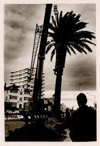
Photograph - Street scene, The Esplanade, St Kilda, c1980s
... ...Canary Island palms...Photograph of The Esplanade showing the installation of Canary Island palm trees along the south side. Palm trees had been planted at Catani Gardens, St Kilda, in the 1930s, but from 1979-1980 more were installed in the 1980s along the foreshore roads from St Kilda to Port Melbourne. ...David Rae Collection St Kilda Canary Island palms Black and white photograph, unmounted The Esplanade, St Kilda Photograph Street scene ...Photograph of The Esplanade showing the installation of Canary Island palm trees along the south side. Palm trees had been planted at Catani Gardens, St Kilda, in the 1930s, but from 1979-1980 more were installed in the 1980s along the foreshore roads from St Kilda to Port Melbourne. Black and white photograph, unmounteddavid rae collection, st kilda, canary island palms -
 St Kilda Historical Society
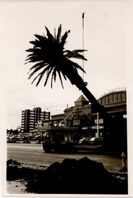
Photograph - Street scene, Esplanade palm, St Kilda, c1980s
... ...Canary Island palms...Photograph showing the installation of a Canary Island palm trees in front of the St Moritz ice skating rink on The Esplanade, St Kilda. ...Photograph showing the installation of a Canary Island palm trees in front of the St Moritz ice skating rink on The Esplanade, St Kilda. ...Photograph showing the installation of a Canary Island palm trees in front of the St Moritz ice skating rink on The Esplanade, St Kilda. Palm trees had been planted at Catani Gardens, St Kilda, in the 1930s, but from 1979-1980 more were installed along the foreshore roads from St Kilda to Port Melbourne. Black and white photograph, unmounteddavid rae collection, st kilda, canary island palms -
 Sunshine and District Historical Society Incorporated
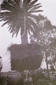
Photograph - Errington Reserve Main Road East Palm Tree Installation 1993 Photographs, Sharon Cavanagh, 16th May 1993
... These photographs, taken by The Advocate newspaper, record the installation of two large Canary Island Palm trees, at the entrance to Errington Reserve, Main Road East, St. ...These photographs, taken by The Advocate newspaper, record the installation of two large Canary Island Palm trees, at the entrance to Errington Reserve, Main Road East, St. ...These photographs, taken by The Advocate newspaper, record the installation of two large Canary Island Palm trees, at the entrance to Errington Reserve, Main Road East, St. Albans. The trees were supplied by the Melbourne firm Established Trees Transplanters and were originally sourced from central Victoria. As of 2026, both trees remain alive.Sunshine Council installing two palm trees around gates to park Errington Reserve St. Albans 203.3errington reserve, main road east, st. albans -
 Eltham District Historical Society Inc
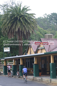
Photograph - Digital Photograph, Alan King, St Andrews Hotel, 2 February 2008
... Fortunately, the hotel and the near-by Canary Island Palm Tree, which is quite rare in this area, survived the 1960s bushfires, along with a few other early buildings. ...Fortunately, the hotel and the near-by Canary Island Palm Tree, which is quite rare in this area, survived the 1960s bushfires, along with a few other early buildings. ...The c1860 St Andrews Hotel, with the c1930 additions, and the Canary Island Palm, and the surrounding site to the title boundaries are historically, socially and aesthetically significant to the Shire of Nillumbik. The St Andrews Hotel is historically significant because it may have given its name 'St Andrews' to the town (another suggestion is that the name came from St Andrews church) and for its connection to Ewen Hugh Cameron (1831-1915) the prosperous local farmer, member of the Eltham Roads Board/Shire Council and local MP. It is also significant as the oldest hotel building in the former Shire of Eltham, as one of the few surviving buildings connected with the Caledonian goldfields era and as one of a handful of early structures to have survived the 1960s bushfires; the additions and alterations to the hotel reflect its long life. The hotel is socially significant because it has served as an important meeting place for more than 160 years. The Canary Island Palm is historically significant as a rare example of exotic tree planting in this rural area. The tree is aesthetically and historically significant as a local landmark and for its contribution to the streetscape and landscape value. Covered under Heritage Overlay, Nillumbik Planning Scheme. Published: Nillumbik Now and Then / Marguerite Marshall 2008; photographs Alan King with Marguerite Marshall.; p71 Built around 1860, St Andrews Hotel has changed little since it first welcomed thirsty gold diggers from the Caledonia Goldfields. The timber building, with gabled roof, beamed ceilings and a massive fireplace, is Nillumbik Shire’s oldest hotel and has always been an important community centre, particularly in its early days. Fortunately, the hotel and the near-by Canary Island Palm Tree, which is quite rare in this area, survived the 1960s bushfires, along with a few other early buildings. St Andrews (formerly Queenstown) was founded on gold, as were Panton Hill (formerly Kingstown), Research and Diamond Creek, from the mid-1850s to the 1860s. But by the early 20th century common use changed the name Queenstown to St Andrews, possibly after this hotel or after the church or the mining district.1 The Caledonia Diggings were probably named by Scottish settlers after the Roman name for Scotland, despite this land bearing little similarity to their homeland.2 Queenstown, which was proclaimed as a township in 1861, was the gold-mining centre on the Upper Diamond and in the 1850s had up to 600 European inhabitants and a small camp of Chinese on the flats along the creek. Queenstown was the administrative centre of the Upper Diamond with three hotels, a brewery and a slaughterhouse.3 It is unclear which hotel was the district’s first, as distinct from the earliest unlicensed grog shops, some of which operated in tents. John Corke Knell was one of eight unlicensed storekeepers supplying drink to miners at Caledonia in 1857, named by Sgt. McNamara of the Caledonia Police Station.4 In February 1859, Knell apparently bought most of the present hotel’s site at the first township land sales. As he was a local storekeeper, he might have first established a store there.5 Knell and his wife Eliza were early licensees of the St Andrews Hotel. The hotel had eight bedrooms – including three for public use – and the dining-room seated 30 people. It is thought they named the hotel St Andrews after Eliza’s hometown of St Andrews in Scotland. St Andrews Hotel was an important local centre in several ways. In the same building the Knells also operated a post office and general store. In 1867 Mrs Knell was appointed Deputy Registrar of Births and Deaths for Queenstown. The hotel was also used to hold inquests into people’s deaths when the police residence became too small.6 The hotel also became a fashionable destination at Christmas for parties from Melbourne. In 1868, possibly following her husband’s death, Mrs Knell applied for a temporary licence, which was then transferred to Robert Smith after their marriage in 1869. But then, possibly after Robert’s death, Mrs Smith operated the hotel until 1892. This contradicts a report in The Evelyn Observer 1882 that JC Knells of the St Andrews Hotel was granted a publican’s licence in the Queenstown Police Court. At that time he was supposed to have been dead for around 14 years! Although Mrs Smith was a respected citizen, known for her geniality and as an ideal hostess, she had a minor brush with the law when she was fined ten shillings for not lighting a lamp outside her licensed premises.7 From 1892 several publicans owned the hotel including W Atkins, from 1895. In 1909 the licensee was apparently Mrs Smith’s son, Walter Knell, who held the licence until at least the 1920s. Not surprisingly, this old hotel has attracted romantic stories. Mrs Smith is said to be seen roaming the pub in her nightdress – even though she was buried in the Queenstown Cemetery in 1911.8 A musical The Hero of Queenstown, set in the hotel, was written and produced by local actor Reg Evans in the 1970s.This collection of almost 130 photos about places and people within the Shire of Nillumbik, an urban and rural municipality in Melbourne's north, contributes to an understanding of the history of the Shire. Published in 2008 immediately prior to the Black Saturday bushfires of February 7, 2009, it documents sites that were impacted, and in some cases destroyed by the fires. It includes photographs taken especially for the publication, creating a unique time capsule representing the Shire in the early 21st century. It remains the most recent comprehenesive publication devoted to the Shire's history connecting local residents to the past. nillumbik now and then (marshall-king) collection, st andrews hotel -
 Melbourne Tram Museum
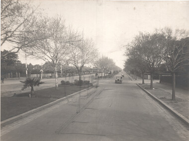
Photograph - St Kilda Road, prior to electrification - set of 2, Sutcliffe Pty Ltd, c1925
... Kilda Road Winter time - Photo shows some of the Poplars and Canary Island Date Palms (Phoenix Canariensis) on the left and the Dutch elm trees on the right. ...Kilda Road Winter time - Photo shows some of the Poplars and Canary Island Date Palms (Phoenix Canariensis) on the left and the Dutch elm trees on the right. ...The photo shows two views prior to the electrification of the cable tram lines in St Kilda Road, probably to show the pre-work condition of the roadways. 1 - St. Kilda Road Winter time - Photo shows some of the Poplars and Canary Island Date Palms (Phoenix Canariensis) on the left and the Dutch elm trees on the right. There is a “Hails Cars Here” sign on the pole. The palms and poplar trees were removed in the 1940s due to the palms drawing up too much water, affecting the plane leaf trees, and the poplars dropping branches. 2 - Photo looking down St.Kilda Road with at least one or two cable trams partially in view. Note the original Oriental Plane leaf trees (Platanus Orientalis), which were replaced by mainly London Plane Leaf trees (Platanus Acerifolia) in the mid-1920s due to disease caused by Gloesporium Nervisequum.Yields information about the appearance of St Kilda Road prior to conversion to electric trams.Black and white image with photographer's stamp on the rear. Second print has notes on the rear.Has the stamp of Sutcliffe Pty Ltd Cromwell buildings on the rear. 2nd print - 4) Tramway poles erected, palms removed, Melb side looking sth along motor track"tramways, st kilda rd, cable converion, electrification -
 Sunshine and District Historical Society Incorporated
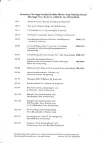
Document - Summary Of Heritage Overlay Schedule Maribyrnong Planning Scheme Places Formerly Within the City Of Sunshine 13th July 2009, Sunshine and District Historical Society Inc, 13th July 2009
... Wimble & Co 13 - 21 Annesley Street Braybrook HO17 3LO Radion Transmission Station 180 Ashley Street Braybrook HO18 Jacks Magazine (Formerly Saltwater River Magazine) 1 Gordon Street Footscray HO45 Former Melbourne Meat Preserving Co Buildings Pipemakers Park (Including Thompson Reserve) Maribyrnong HO 64) Part Of Ordnance Factory Former No 1 Forge (Demolished) HO71 Part Of Ordnance Factory Former Royal Australian Field Artillery Barracks Wests Road Maribyrnong HO72 ETA Factory 254 Ballarat Road Braybrook (Being Demolished) HO83 Inspection Headquarters (Building 72) Ordnance Reserve Maribyrnong HO86 Pilkington ACI 234 Ballarat Road Braybrook HO91 Braybrook Hotel 351 Ballarat Road Braybrook HO92 Bluestone Cistern (Archaeological Site) 8 - 9 Belvedere Close Maribyrnong HO99 Raleigh Castle (Archaeological Site) 14 Belvedere Close Maribyrnong HO100 Raleigh Castle (Archaeological Site) 15/17 & 1 - 18/18 Belvedere Close Maribyrnong HO100 Kurrajong Street Trees (25 Kurrajong Trees) Bloomfield Avenue Maribyrnong HO105 Solomon's Ford (Canning Street Ford) Maribyrnong River Near Burke Street Braybrook HO109 6738 - Summary Of Heritage Overlay Schedule Maribyrnong Planning Scheme Places Formerly Within the City Of Sunshine Page 2.jpg Pepper Trees, Sugar Gums, Kurrajongs and Canary Island Palms Maribyrnong River Plantation off Chifley Drive Maribyrnong HO110 Klipspringer 40 - 54 Cranwell Street Braybrook HO113 Pridham's Peerless Holdings 19 21 Evans Street Braybrook (Deleted from Overlay) HO118 Raleigh Manager's House (Archaeological Site) 1 & 3 Fabian Court Maribyrnong HO119 Raleigh Castle (Archaeological Site) 1 - 8/5 Fabian Court Maribyrnong HO120 Raleigh Manager's House (Archaeological Site) 2 & 4 Grandview Avenue Maribyrnong HO133 Ralph McKay 44 Hampstead Road Maidstone (Demolished) HO134 Pyrotechnic Division OFM 61 - 71 Hampstead Road Maribyrnong (HO135) Maribyrnong Reserve Grandstand off Hortense Street Maribyrnong HO137 Williamson House 182 Mitchell Street Maidstone HO141 Solomon's House (Archaeological Site) Medway Golf Club 57 Omar Street Maidstone Central Drawing Office (Building 71) Ordnance Reserve Maribyrnong (HO151) Pacific Carpets 35 - 65 Paramount Road corner Indwe Street Tottenham Dale Stables and Elm and Pepper Trees Plantation Street and Chifley Drive Maribyrnong HO153) Olex Cales 207 Sunshine Road Tottenham HO162 Whitshire Files 213 Sunshine Road Tottenham HO163 Black Arch Bridge off Sunshine Road Tottenham HO164 Dale House 44 The Esplanade Maribyrnong HO165 Hardiman House and Garden 76 The Esplanade Maribyrnong HO166 Raleigh Mansion (Archaeological Site) City View Reserve 11 City View Drive Maribyrnong...Wimble & Co 13 - 21 Annesley Street Braybrook HO17 3LO Radion Transmission Station 180 Ashley Street Braybrook HO18 Jacks Magazine (Formerly Saltwater River Magazine) 1 Gordon Street Footscray HO45 Former Melbourne Meat Preserving Co Buildings Pipemakers Park (Including Thompson Reserve) Maribyrnong HO 64) Part Of Ordnance Factory Former No 1 Forge (Demolished) HO71 Part Of Ordnance Factory Former Royal Australian Field Artillery Barracks Wests Road Maribyrnong HO72 ETA Factory 254 Ballarat Road Braybrook (Being Demolished) HO83 Inspection Headquarters (Building 72) Ordnance Reserve Maribyrnong HO86 Pilkington ACI 234 Ballarat Road Braybrook HO91 Braybrook Hotel 351 Ballarat Road Braybrook HO92 Bluestone Cistern (Archaeological Site) 8 - 9 Belvedere Close Maribyrnong HO99 Raleigh Castle (Archaeological Site) 14 Belvedere Close Maribyrnong HO100 Raleigh Castle (Archaeological Site) 15/17 & 1 - 18/18 Belvedere Close Maribyrnong HO100 Kurrajong Street Trees (25 Kurrajong Trees) Bloomfield Avenue Maribyrnong HO105 Solomon's Ford (Canning Street Ford) Maribyrnong River Near Burke Street Braybrook HO109 6738 - Summary Of Heritage Overlay Schedule Maribyrnong Planning Scheme Places Formerly Within the City Of Sunshine Page 2.jpg Pepper Trees, Sugar Gums, Kurrajongs and Canary Island Palms Maribyrnong River Plantation off Chifley Drive Maribyrnong HO110 Klipspringer 40 - 54 Cranwell Street Braybrook HO113 Pridham's Peerless Holdings 19 21 Evans Street Braybrook (Deleted from Overlay) HO118 Raleigh Manager's House (Archaeological Site) 1 & 3 Fabian Court Maribyrnong HO119 Raleigh Castle (Archaeological Site) 1 - 8/5 Fabian Court Maribyrnong HO120 Raleigh Manager's House (Archaeological Site) 2 & 4 Grandview Avenue Maribyrnong HO133 Ralph McKay 44 Hampstead Road Maidstone (Demolished) HO134 Pyrotechnic Division OFM 61 - 71 Hampstead Road Maribyrnong (HO135) Maribyrnong Reserve Grandstand off Hortense Street Maribyrnong HO137 Williamson House 182 Mitchell Street Maidstone HO141 Solomon's House (Archaeological Site) Medway Golf Club 57 Omar Street Maidstone Central Drawing Office (Building 71) Ordnance Reserve Maribyrnong (HO151) Pacific Carpets 35 - 65 Paramount Road corner Indwe Street Tottenham Dale Stables and Elm and Pepper Trees Plantation Street and Chifley Drive Maribyrnong HO153) Olex Cales 207 Sunshine Road Tottenham HO162 Whitshire Files 213 Sunshine Road Tottenham HO163 Black Arch Bridge off Sunshine Road Tottenham HO164 Dale House 44 The Esplanade Maribyrnong HO165 Hardiman House and Garden 76 The Esplanade Maribyrnong HO166 Raleigh Mansion (Archaeological Site) City View Reserve 11 City View Drive Maribyrnong A4 Stapled Document Document Summary Of Heritage Overlay Schedule Maribyrnong Planning Scheme Places Formerly Within the City Of Sunshine 13th July 2009 Sunshine and District Historical Society Inc ...These places were formerly within the City of Sunshine prior to the Council mergers of 19946738 - Summary Of Heritage Overlay Schedule Maribyrnong Planning Scheme Places Formerly Within the City Of Sunshine Page 1.jpg Munition Workers' Housing Heritage Area Braybrook HO5 War Service Homes Heritage Maribyrnong HO12 F.T. Wimble & Co 13 - 21 Annesley Street Braybrook HO17 3LO Radion Transmission Station 180 Ashley Street Braybrook HO18 Jacks Magazine (Formerly Saltwater River Magazine) 1 Gordon Street Footscray HO45 Former Melbourne Meat Preserving Co Buildings Pipemakers Park (Including Thompson Reserve) Maribyrnong HO 64) Part Of Ordnance Factory Former No 1 Forge (Demolished) HO71 Part Of Ordnance Factory Former Royal Australian Field Artillery Barracks Wests Road Maribyrnong HO72 ETA Factory 254 Ballarat Road Braybrook (Being Demolished) HO83 Inspection Headquarters (Building 72) Ordnance Reserve Maribyrnong HO86 Pilkington ACI 234 Ballarat Road Braybrook HO91 Braybrook Hotel 351 Ballarat Road Braybrook HO92 Bluestone Cistern (Archaeological Site) 8 - 9 Belvedere Close Maribyrnong HO99 Raleigh Castle (Archaeological Site) 14 Belvedere Close Maribyrnong HO100 Raleigh Castle (Archaeological Site) 15/17 & 1 - 18/18 Belvedere Close Maribyrnong HO100 Kurrajong Street Trees (25 Kurrajong Trees) Bloomfield Avenue Maribyrnong HO105 Solomon's Ford (Canning Street Ford) Maribyrnong River Near Burke Street Braybrook HO109 6738 - Summary Of Heritage Overlay Schedule Maribyrnong Planning Scheme Places Formerly Within the City Of Sunshine Page 2.jpg Pepper Trees, Sugar Gums, Kurrajongs and Canary Island Palms Maribyrnong River Plantation off Chifley Drive Maribyrnong HO110 Klipspringer 40 - 54 Cranwell Street Braybrook HO113 Pridham's Peerless Holdings 19 21 Evans Street Braybrook (Deleted from Overlay) HO118 Raleigh Manager's House (Archaeological Site) 1 & 3 Fabian Court Maribyrnong HO119 Raleigh Castle (Archaeological Site) 1 - 8/5 Fabian Court Maribyrnong HO120 Raleigh Manager's House (Archaeological Site) 2 & 4 Grandview Avenue Maribyrnong HO133 Ralph McKay 44 Hampstead Road Maidstone (Demolished) HO134 Pyrotechnic Division OFM 61 - 71 Hampstead Road Maribyrnong (HO135) Maribyrnong Reserve Grandstand off Hortense Street Maribyrnong HO137 Williamson House 182 Mitchell Street Maidstone HO141 Solomon's House (Archaeological Site) Medway Golf Club 57 Omar Street Maidstone Central Drawing Office (Building 71) Ordnance Reserve Maribyrnong (HO151) Pacific Carpets 35 - 65 Paramount Road corner Indwe Street Tottenham Dale Stables and Elm and Pepper Trees Plantation Street and Chifley Drive Maribyrnong HO153) Olex Cales 207 Sunshine Road Tottenham HO162 Whitshire Files 213 Sunshine Road Tottenham HO163 Black Arch Bridge off Sunshine Road Tottenham HO164 Dale House 44 The Esplanade Maribyrnong HO165 Hardiman House and Garden 76 The Esplanade Maribyrnong HO166 Raleigh Mansion (Archaeological Site) City View Reserve 11 City View Drive Maribyrnong -
 Eltham District Historical Society Inc
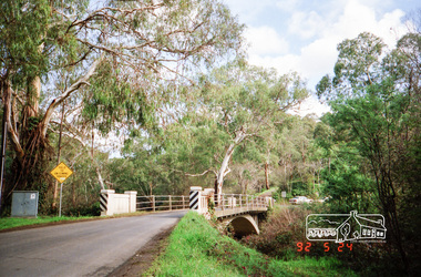
Photograph, Monash Bridge, Arthurs Creek Road, Hurstbridge, Eltham Heritage Tour, 24 May 1992, 24/05/1992
... Canary Island pine, a Canadian cedar and probably a spruce. Radiata pines and a thick bolled peppercorn surround the little cemetery. Continuing along Main Street we notice elm trees planted as a war memorial, then on the left a 1930 timber house, a 1910 store and residence, resplendent with wrought iron trim, a double fronted Hardware Store and cypresses on the back alignment of a new vacant block. On the right side of the street is a less interesting attempt at an 'in character' shop. Further on are more early homes, one tucked away at the rear with two tall palms...Canary Island pine, a Canadian cedar and probably a spruce. Radiata pines and a thick bolled peppercorn surround the little cemetery. Continuing along Main Street we notice elm trees planted as a war memorial, then on the left a 1930 timber house, a 1910 store and residence, resplendent with wrought iron trim, a double fronted Hardware Store and cypresses on the back alignment of a new vacant block. On the right side of the street is a less interesting attempt at an 'in character' shop. Further on are more early homes, one tucked away at the rear with two tall palms ...ELTHAM HERITAGE TOUR The Society excursion on 24th May 1992 was arranged by David Bick, leader of the team carrying out the Shire's heritage study. David selected a number of sites or buildings identified in the study, some of them lesser known components of the Shire's heritage. The tour commenced at the Eltham Shire Office at 10.00 am. Travel was by private car and mini-bus with stops at about twelve locations for commentary by David.It included a short walk in Hurstbridge and lunch at Kinglake. Highlights of the tour included: - 10 am Leave from Shire Offices - 3 Important Trees - A Physical Link to Eltham's First Settlers - Toorak Mansion Gates - A Surviving Farm House - An Intact Circa 1900 Main Street - First Settlers - Gold Miners, and Timber-getters - An Early Hotel - A Pioneering Homestead - Changing Eltham Shire - 20th Century - 4 pm Afternoon Tea and Finish Tour Extract from ELTHAM CULTURAL HERITAGE TOUR (Newsletter No. 85, July 1992, by Bettina Woodburn) "On the Arthurs Creek Road is a bridge designed by Monash, which we admired before walking across the little park with a mud-brick and timber shelter, to the Hurst family graveyard. There are two marked graves, one, Henry who was shot by Burke the bushranger and a cairn has a plaque listing others buried here from 1866 onwards. Burke was captured and tied to the wheel of a dray under the eucalypt near the waterhose/standpipe. Close by the kindergarten, at this place are three trees on the National Trust Register, a Canary Island pine, a Canadian cedar and probably a spruce. Radiata pines and a thick bolled peppercorn surround the little cemetery. Continuing along Main Street we notice elm trees planted as a war memorial, then on the left a 1930 timber house, a 1910 store and residence, resplendent with wrought iron trim, a double fronted Hardware Store and cypresses on the back alignment of a new vacant block. On the right side of the street is a less interesting attempt at an 'in character' shop. Further on are more early homes, one tucked away at the rear with two tall palms by the front steps. Another curiosity is a rounded veranda corner and there are more galvanised iron sheds or garages, before a mud-brick Dentist's Surgery. Beyond the round-a-about is St Peters Church, of mud-brick construction shared by Catholic and Anglican parishioners, overlooking the river flood plain. Leaving Hurstbridge on the Kinglake Road, we ate our picnic lunch beside the communication tower and enjoyed views of Melbourne, Yan Yean Reservoir and the distant Dandenongs beyond the spreading suburbs. Next we drove to the North West boundary of the Shire at Masons Falls Road towards Whittlesea. On the way to the North East Boundary we passed St Peters, a yellow wooden Church with a Tudor Archway; built in the early 1920's in the style of the 1860's. From the Healesville-Kinglake road the rolling hills had European aspects, the hedged fields and chestnut trees. Then it was back down the Hurstbridge Road through 'Aussie' bush of towering gums, with bracken and scrubby understorey, the Kinglake National Park, before more open country with deciduous trees planted in line, and a creek lined with willows."Record of the Society's history and activities and highlighting various aspects of the Heritage Study undertaken by David Bick used to create the future heritage overlay for the Shire of Eltham and later Nillumbik Shire.Roll of 35mm colour negative film, 4 stripsKodak Gold 100 5095shire of eltham historical society, activities, heritage tour, hurstbridge, monash bridge, arthurs creek road -
 Sunshine and District Historical Society Incorporated
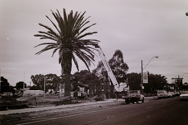
Photograph - Errington Reserve Palm Tree Planting, The Advocate, 1993
... Canary Island tree in the reserve to reflect the 1920's - 1940's civic planting trends. As of the 8th January 2026 this tree is still alive and growing in the reserve. Errington Reserve is one of the few reserves created by a private donation, and one of the earliest examples of a woman shaping public space in the St. Albans district. Main Road East St. Albans Errington Reserve Alice Errington 5658 - Errington Reserve Palm ...In 1910, Alice Errington donated six acres of land to the people of St Albans. The land donated was located on the south side of Boundary Road (Now Main Road East), which was the border between the Shire of Braybrook and the Shire of Keilor, In reality, the community was one, and Alice intended the land provide recreation facilities for both the Shire of Braybrook and the Shire of Keilor residents. In 1929, the reserve trustees decided to vest the land to the Shire of Braybrook Council due to ongoing rate costs, liability for road construction costs and the need for formal municipal management. The memorial wrought iron gates were added later and are one of the few early memorials in St Albans that have a tangible link to the pioneer era of the district. Over the years the reserve has seen various landscaping design changes, and various sporting club rooms and community buildings added. This photograph taken in 1993, captures the planting of a Canary Island tree in the reserve to reflect the 1920's - 1940's civic planting trends. As of the 8th January 2026 this tree is still alive and growing in the reserve. Errington Reserve is one of the few reserves created by a private donation, and one of the earliest examples of a woman shaping public space in the St. Albans district.5658 - Errington Reserve Palm Tree Planting (Sun Adv 203.3) 1993 Photo 02.JPGmain road east, st. albans, errington reserve, alice errington
